PASCO COUNTY, FLORIDA INTEROFFICE MEMORANDUM. REFERENCES: Land Development Code, Planner II
|
|
|
- Brandon Hart
- 5 years ago
- Views:
Transcription
1 PSCO COUNTY, FLORID INTEROFFICE MEMORNDUM TO: Development Review Committee DTE: 5// FILE: PDD-933 FROM: Carol B. Clarke Zoning dministrator ssistant Planning and Development dministrator SUBJECT: Behnke/Legacy MPUD Master Roadway Plan and lternative Standard DRC: 5//, :30 p.m., NPR Recommendation: pproval STFF: Justyna Buszewski REFERENCES: Land Development Code, Planner II Section 5, MPUD Petition No Comm. Dist. The following is presented to the Development Review Committee for consideration. PROJECT DESCRIPTION: Project Name: pplicant s Name: Location: creage: Zoning District: Future Land Use: No. of Dwelling Units: 5,050 Commercial Office Light Industrial/Office Behnke/Legacy MPUD (Master Planned Unit Development) Lane Gander, Managing Director The north side of S.R. 5, approximately miles west of Suncoast Parkway, Sections 3,, 5, and 36, Township 6 South, Range 7 East cres, m.o.l. MPUD Master Planned Unit Development PD (Planned Development), CON (Conservation Lands),83 (based on maximum land-use trade off) 00,000 square feet 80,000 square feet 350,000 square feet BCKGROUND:. On December 8, 007, the Board of County Commissioners (BCC) approved the Legacy MPUD Master Planned Unit Development, Petition No On October 0, 03, the Zoning dministrator approved a Non-substantial Modification to the MPUD. (PDD-933) Page of
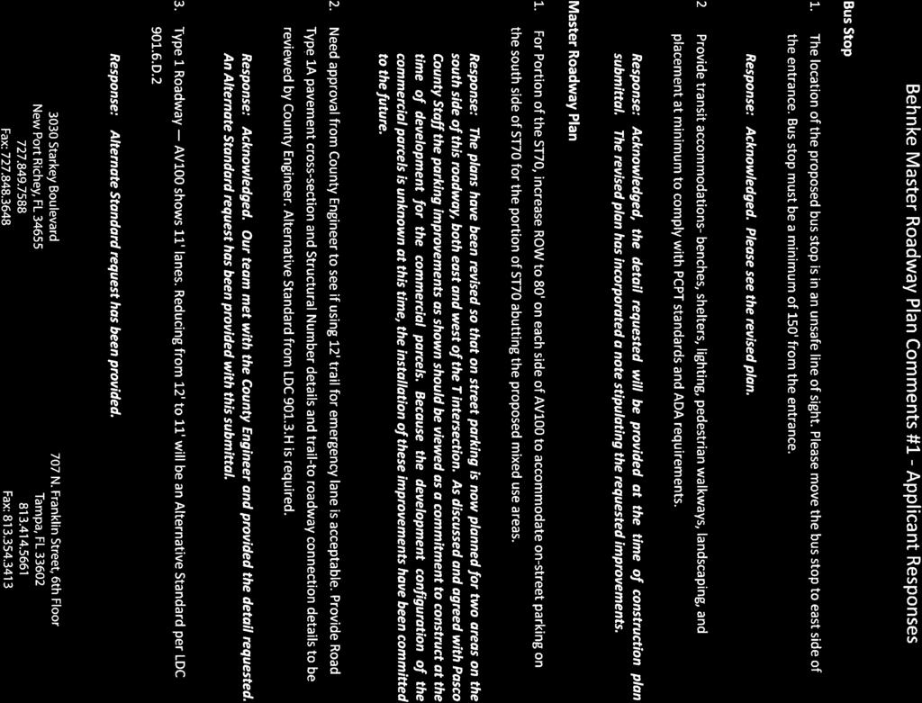
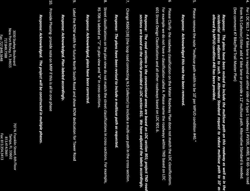
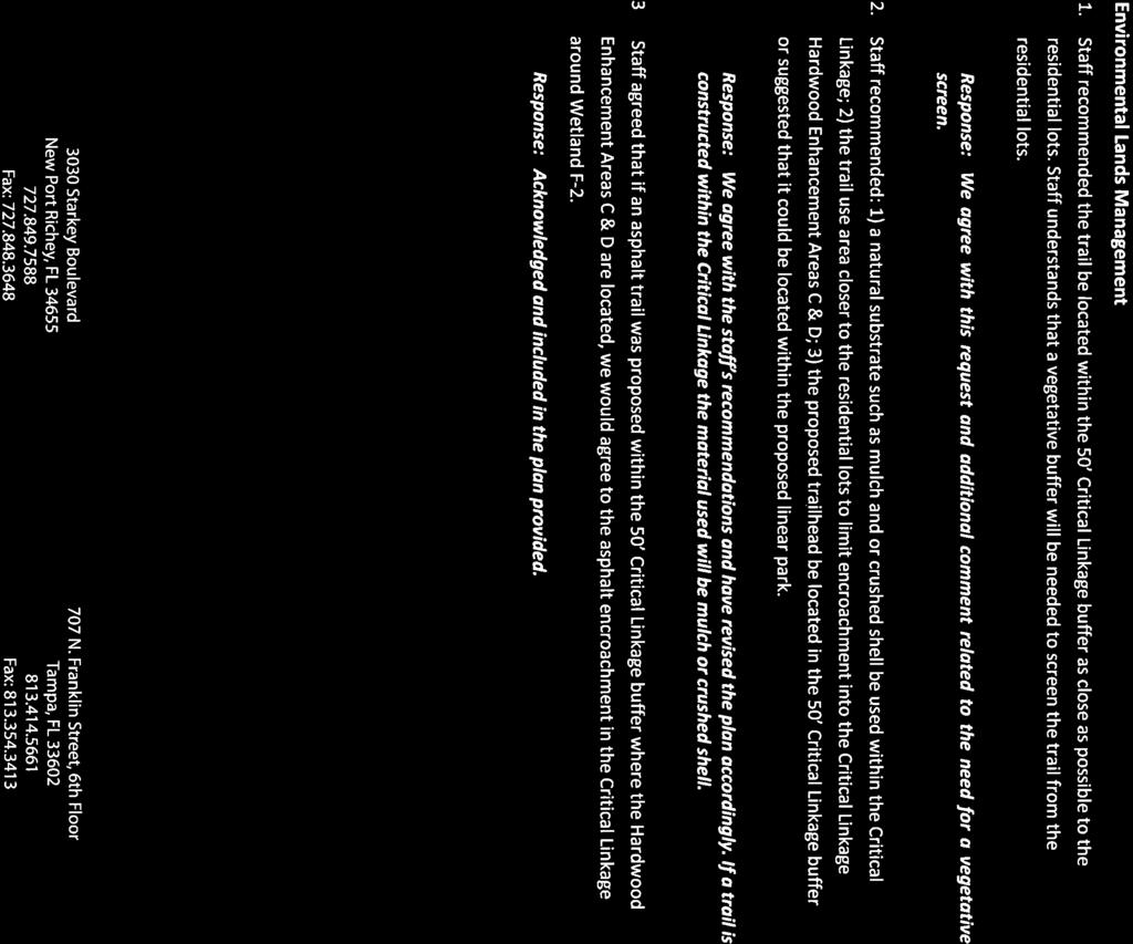
2 DEVELOPER'S REQUEST:. pproval of the Master Roadway Plan for Behnke/Legacy MPUD in conjunction with Condition No. 38; and. n lternative Standard from Land Development Code (LDC) Section 90.3.H, Number and Spacing of Driveways. a. The proposed -foot-wide stabilized grass Emergency ccess section is designed to allow the travel of emergency vehicles over it, and adheres to the LDC, Chapter 900, Section 90.3.H, by providing one single emergency lane. The addition is a third -foot-wide lane as the emergency access, with a two-foot-wide curb is part of the emergency access and a nine-footwide stabilized grass strip. The proposed -foot-wide lane is located adjacent to the southbound lane and will serve the purpose of an emergency access. The roadway is located in the section of the road designated as RS70B on the Master Roadway Plan (MRP) that crosses a wetland. The proposed emergency access lane will provide for an additional ingress/egress into a section of the property exceeding 00 lots which has no other access. third paved lane would encourage drivers to drive faster. Using the stabilized grass area as an emergency lane instead of a paved lane will provide a wider green area buffer between the travel lane and the multiuse path, increasing the safety for the multiuse path users. The stabilized green area emergency lane will increase walkability due to narrower pavement. 3. n lternative Standard from the LDC, Section 90.6.D., Pavement Width FINDINGS OF FCT: a. The proposed request consists of reducing the lane widths from a -footwide travel lane to an -foot-wide travel lane, for a Type roadway. The LDC, Chapter 900, Section 90.6.D.. The request is for a road designated as V shown on the Master Roadway Plan. The proposed roadway has two northbound and two southbound lanes, each having a -foot pavement width, with left and right turn lanes. The -foot right-of -way also contains landscaping, sidewalk, and a multiuse path. This roadway serves as the entrance to a TND type development which has been designed to provide a walkable environment. The request for reducing the lane widths within this section is to extend a safe walking environment through the entrance. The Florida Department of Transportation (FDOT) Manual of Uniform Minimum Standards for Design, Construction and Maintenance for Street and Highways (Florida Greenbook), allows for - foot- lanes for collector streets in Chapter 3, Table MPUD Master Planned Unit Development Rezoning Petition No. 6668, Conditions of pproval No. 38, requires that prior to the first preliminary development plan/preliminary site plan submittal, the Master Developer shall submit a Master (PDD-933) Page of
3 Roadway Plan to the Planning and Development Department for review. pproval of the MRP must be obtained from the DRC prior to the first preliminary plan/preliminary site plan submittal.. The proposed MRP for Behnke/Legacy MPUD is in compliance with Condition of pproval No. 38. The attached MRP includes right-of-way widths, roadway cross sections, number of lanes, intersection geometry, phasing, design speeds, internal access points, and alignment for major County collector and arterial roadways within the MPUD. 3. The MRP demonstrates compliance with the County s collector and arterial design and spacing standards of the LDC, Section 90., Transportation - Corridor Spacing. The lternative Standard from LDC, Section 90.3.H, Number and Spacing of Driveways, has been reviewed and approved by Planning and Development staff and by the County Engineer. The proposed -foot-wide stabilized grass Emergency ccess section is designed to allow the travel of emergency vehicles over it, and adheres to the LDC, Section 90.3.H 5. The lternative Standard from LDC, Section 90.6.D., Pavement Width, has been reviewed and approved by Planning and Development Staff and by the County Engineer. The proposed reduction of the lane widths from a -foot- wide travel lane to an -foot-wide travel lane, for a Type roadway is consistent with the FDOT Florida Greenbook, which allows for -foot-lanes for collector streets. Staff agrees that the proposed alternative -foot-travel lane is more conducive to a walkable environment in a traditional neighborhood type of development. RECOMMENDTION: The Planning and Development Department has reviewed the Master Roadway Plan and lternative Standard and recommends pproval with the following conditions:. The developer acknowledges that no construction is allowed with the approval of this plan.. The applicant/developer acknowledges and agrees that if there is a conflict between these conditions of approval and the MPUD Conditions of pproval, the MPUD Conditions of pproval shall supersede. 3. ll intersection geometry depicted on the MRP is subject to the corresponding MPUD modification and shall be subject to the corresponding MPUD conditions of approval and associated alternative standard. TTCHMENTS:. Master Roadway Plan. lternative Standards 3. Master Roadway Plan Comments No. - pplicant Responses (PDD-933) Page 3 of
4 DEVELOPER'S CKNOWLEDGMENT: The developer/applicant acknowledges that it has read, understood, and accepted the above-listed conditions of approval. Date Signature Print Name Title STTE OF FLORID COUNTY OF The foregoing instrument was acknowledged before me this (date), by (name of corporation acknowledging) a (State or place of incorporation) corporation, on behalf of the corporation. He/she is personally known to me or who has produced (type of identification) as identification. Seal: NOTRY (PDD-933) Page of
5 ST70 FUTURE TOWER ROD ' RIGHT-OF-WY DEDICTION CRITICL LINKGE DRIVEWY DRIVEWY 3 V DRIVEWY 6 V80 S.R. 5 S.R. 5 S.R. 5 ST70 DRIVEWY 3 V EXISTING NEW CONCEPTUL INTERSECTION GEOMETRY S RE BSED ON MPUD REQUIREMENTS. FINL GEOMETRY WILL BE DETERMINED BY FINL ENGINEERED DRWINGS PPROVED BY F.D.O.T. ND PSCO COUNTY. RS60-TR BUFFER (TYP) PHSE C PHSE PHSE B 3 RS70 FUTURE NORTH-SOUTH ROD 3 RIGHT-OF-WY 00' RIGHT-OF-WY B RS60B PHSE ST 60 L L ST60 ST 69 P P SEE GEOMETRY DETIL BOVE PHSE ST70 LN56 ST60 L ST63 L L ST60 RS70B LN56 ST 63 L ST60 PHSE D POSSIBLE FUTURE CONNECTION. LIGNMENT SUBJECT TO CHNGE DRIVEWY SEE GEOMETRY DETIL BOVE TO BE SIGNLIZED IF WRRNTED DRIVEWY RIGHT IN / RIGHT OUT V SHELTER WITH BENCHES ND LIGHTING 80' 00' 80' STTE ROD 5 DRIVEWY 3 SEE GEOMETRY DETIL BOVE POSSIBLE BUS STOP LOCTION TND BOUNDRY PHSE WIDE (MIN.) TO BE SIGNLIZED WHEN WRRNTED DRIVEWY RIGHT IN / RIGHT OUT B V80 BUS STOP DETIL NOT TO SCLE NOTE: CONSTRUCTION PLNS WILL PROVIDE DETILS ND PLCEMENT OF SUCH THINGS S BENCHES, SHELTERS, LIGHTING, PEDESTRIN WLKWYS, LNDSCPING TO MEET P.C.P.T. STNDRDS ND.D.. REQUIREMENTS. MIXED USE 80' ' Travel Lane C L C L ' LEGEND POSSIBLE BUS STOP* RIGHT IN / RIGHT OUT DRIVEWY ON S.R. 5 INTERNL DRIVEWYS S DRIVEWY 5 RIGHT IN / RIGHT OUT DRIVEWY 6 SEE GEOMETRY DETIL BOVE V80 B POSSIBLE FUTURE CONNECTION MIN INTERNL RODWYS RISED RISED B 3 B V NON-TND RODWY CLSSIFICTION BSED ON P.C.L.D.C. 90 TND RODWY CLSSIFICTION BSED ON P.C.L.D.C. 60 RODWY CROSS SECTION PHSE LINE... min. VENUE WITH 80' WIDE RIGHT-OF-WY WITH ' WIDE S (NO PRKING) V80 POSTED SPEED / DESIGN SPEED 30 MPH B ' DOUBLE EGRESS 9 MEDIN ' DOUBLE INGRESS min. P LIMITS OF TND PRKING NOT SHOWN IN CROSS SECTION ST70 (LTERNTIVE)** * THE ULTIMTE LOCTION ND TIME OF CONSTRUCTION OF POSSIBLE BUS STOP HS YET TO BE DETERMINED. ** TO BE PROVIDED T OR BEFORE THE TIME OF CONSTRUCTION FOR PHSE 6 & 7... BEHNKE RNCH MSTER RODWY PLN PSCO COUNTY, FLORID PREPRED FOR: WTER MIN TYPE 'D' V 605 PLENCI CLUB DRIVE ST. UGUSTINE, FLORID 3095 POSTED SPEED / DESIGN SPEED 30 MPH VENUE WITH 00' WIDE RIGHT-OF-WY WITH ' WIDE S (NO PRKING) THINK IT. CHIEVE IT N. F R N K L I N S T R E E T, 6 T H F L O O R, T M P, F L O R I D PHONE: (800) FX: (77) C.. NO.7 JOB NO C NOTES. LL STREETS RE TO BE PUBLIC STREETS ND MINTINED BY THE CDD. LNDSCPING WITHIN THE RIGHT-OF-WY WILL BE MINTINED BY THE CDD ND WILL BE THE PPROPRITE HEIGHT WITHIN THE CLER SIGHT TRINGLE EPN DTE THIS PLN IS CONCEPTUL ND LL CREGES, UNIT QUNTITIES, UNIT TYPES, UNIT SIZES, MENITIES, PTHS, STREET, PRK ND BUILDING TYPES ND LOCTIONS RE PPROXIMTE ND SUBJECT TO CHNGE. LOCTION ND LIGNMENT OF RODWYS ND CCESS POINTS SHOWN RE PPROXIMTE ND SUBJECT TO CHNGE BSED ON FINL ENGINEERING, DESIGN ND PERMITTING REQUIREMENTS. INDIVIDUL RODWY SECTIONS MY BE LTERED WITH PPROPRITE JUSTIFICTION WITHIN THE LLOWBLE PRMETERS OF THE PSCO LND DEVELOPMENT CODE DURING FUTURE SITE CONSTRUCTION PLN PPLICTIONS. LL IDES, DESIGNS, GRPHICS RENDERINGS, DIMENSIONS, PLNS, ND OTHER DEPICTIONS HEREIN RE CONCEPTUL ONLY ND RE SUBJECT TO CHNGE ND THEREFORE RE NOT GURNTEE OF HOW THE ITEMS WILL PPER UPON COMPLETION 5--0 PER COUNTY COMMENTS JH NO. DTE REVISIONS PP'D BY DESIGNED JH CHECKED SMR DRWN Q.C. JH PGE OF
6 ' ' EMERGENCY CCESS ' 6. 9' STBILIZED GRSS 70' ' 7. OFFSET ' ' ' ' 70' 6' (TND OR CONVENTIONL)... VLLEY/ MOUNTBLE RS70B POSTED SPEED / DESIGN SPEED 0 MPH ' 60' MIMI / MOUNTBLE STREET WITH 70' WIDE RIGHT-OF-WY WITH ' WIDE S & EMERGENCY CCESS (NO PRKING)... (TND OR CONVENTIONL) WTER MIN MIXED USE SEE PEDESTRIN & PRK PLN FOR MULTIUSE PTH LOCTION TRNSITION TO RISED DJCENT TO ' RS70 70' Travel Lane C L 9' POSTED SPEED / DESIGN SPEED 0 MPH ' PRKING MIMI/MOUNTBLE STREET WITH 70' WIDE RIGHT-OF-WY WITH ' WIDE S (NO PRKING) LLEY LODED TND (TND OR CONVENTIONL)... WTER MIN 8' LTERNTIVE 8' (SEE PRK/PED PLN) MIMI/MOUNTBLE STREET WITH 60' WIDE RIGHT-OF-WY WITH ' WIDE S (NO PRKING) POSTED SPEED / DESIGN SPEED 0 MPH 60' ' 3... (TND OR CONVENTIONL)... RISED 6. LNDSCPE LTERNTIVE PRKING PRKING LONG MIXED USE 6' ' Travel Lane C L 9' RISED TND STREET WITH 70' WIDE RIGHT-OF-WY WITH ' WIDE S ( PRKING) 60' 3. OFFSET ST70 POSTED SPEED / DESIGN SPEED 5 MPH ' PRKING... LLEY LODED TND LLEY LODED TND WTER MIN... PRKING ' MIMI/MOUNTBLE RS60B POSTED SPEED / DESIGN SPEED 5 MPH B STREET WITH 60' WIDE RIGHT-OF-WY WITH ' WIDE S (NO PRKING) 63' 3 ' PRKING... LLEY LODED TND (TND OR CONVENTIONL) WTER MIN... MIMI/MOUNTBLE ST60 POSTED SPEED / DESIGN SPEED 0 MPH TND STREET WITH 60' WIDE RIGHT-OF-WY RISED WITH ' WIDE S ( PRKING) ' 60' 36' ' LEFT TURN ' RIGHT TURN... (TND OR CONVENTIONL) LLEY LODED TND WTER MIN... WTER MIN. ST63 RISED POSTED SPEED / DESIGN SPEED 0 MPH TND STREET WITH 63' WIDE RIGHT-OF-WY WITH ' WIDE S ( PRKING) PRKING NOTES. LL STREETS RE TO BE PUBLIC STREETS ND MINTINED BY THE CDD. LNDSCPING WITHIN THE RIGHT-OF-WY WILL BE MINTINED BY THE CDD ND WILL BE THE PPROPRITE HEIGHT WITHIN THE CLER SIGHT TRINGLE ' B 69' 3 ST69 ' PRKING RISED POSTED SPEED / DESIGN SPEED 0 MPH B. TND STREET WITH 69' WIDE RIGHT-OF-WY WITH ' WIDE S ( PRKING). OFFSET ' LLEY LODED TND WTER MIN* ' * VLLEY (TYP.) (S NEEDED) ' 56' 0' ' 6' ' * LLEY % GRDE ' RIBBON (TYP.) RISED. LLEY LODED TND * * FORCE MIN, WTER MIN, GRVITY SEWER ND REUSE MIN MY NOT BE REQUIRED. LN56 POSTED SPEED / DESIGN SPEED 0 MPH B TND WITH 56' WIDE RIGHT-OF-WY WITH ' WIDE S (YIELD STREET) L TND LLEY WITH 0' WIDE RIGHT-OF-WY WITH 6' WIDE S (NO PRKING) THIS PLN IS CONCEPTUL ND LL CREGES, UNIT QUNTITIES, UNIT TYPES, UNIT SIZES, MENITIES, PTHS, STREET, PRK ND BUILDING TYPES ND LOCTIONS RE PPROXIMTE ND SUBJECT TO CHNGE. LOCTION ND LIGNMENT OF RODWYS ND CCESS POINTS SHOWN RE PPROXIMTE ND SUBJECT TO CHNGE BSED ON FINL ENGINEERING, DESIGN ND PERMITTING REQUIREMENTS. INDIVIDUL RODWY SECTIONS MY BE LTERED WITH PPROPRITE JUSTIFICTION WITHIN THE LLOWBLE PRMETERS OF THE PSCO LND DEVELOPMENT CODE DURING FUTURE SITE CONSTRUCTION PLN PPLICTIONS. LL IDES, DESIGNS, GRPHICS RENDERINGS, DIMENSIONS, PLNS, ND OTHER DEPICTIONS HEREIN RE CONCEPTUL ONLY ND RE SUBJECT TO CHNGE ND THEREFORE RE NOT GURNTEE OF HOW THE ITEMS WILL PPER UPON COMPLETION -6-0 PER COUNTY COMMENTS... MENITY CENTER WTER MIN NO. BEHNKE RNCH MSTER RODWY PLN PSCO COUNTY, FLORID DTE MIMI/MOUNTBLE RS60-TR POSTED SPEED / DESIGN SPEED 0 MPH PREPRED FOR: 605 PLENCI CLUB DRIVE ST. UGUSTINE, FLORID 3095 REVISIONS STREET WITH 60' WIDE RIGHT-OF-WY T TOWER ROD THINK IT. CHIEVE IT N. F R N K L I N S T R E E T, 6 T H F L O O R, T M P, F L O R I D PHONE: (800) FX: (77) C.. NO.7 PP'D BY JOB NO. EPN DTE DESIGNED JH CHECKED SMR C -0-0 DRWN Q.C. JH 3 PGE OF
7 ' ' EMERGENCY CCESS 80' ' '... MIMI / MOUNTBLE RS70B WITHOUT THE LTERNTE STNDRD (*) N.T.S. ' ' EMERGENCY CCESS ' 6. 9' STBILIZED GRSS 70' ' 7. OFFSET ' L RODWY C '... VLLEY/ MOUNTBLE MIMI / MOUNTBLE RS70B WITH THE LTERNTE STNDRD (*) N.T.S. RS70B RODWY CROSS SECTION B NON-TND RODWY CLSSIFICTION BSED ON P.C.L.D.C. 90 (*) REFER TO THE BEHNKE RNCH MSTER RODWY PLN FOR THE ROD LOCTION BEHNKE RNCH LTERNTE STNDRD EXHIBIT EMERGENCY CCESS EPN DTE JOB NO C THINK IT. CHIEVE IT N. F R N K L I N S T R E E T, 6 T H F L O O R, T M P, F L O R I D PHONE: (800) FX: (77) C.. NO.7 DESIGNED JH CHECKED SMR DRWN Q.C. JH PGE OF
8 0' min. DOUBLE EGRESS 3' MEDIN DOUBLE INGRESS ' min. TYPE 'D' V WITHOUT THE LTERNTE STNDRD (*) N.T.S. min. ' DOUBLE EGRESS 9 MEDIN ' DOUBLE INGRESS min. TYPE 'D' V WITH THE LTERNTE STNDRD (*) N.T.S. V RODWY CROSS SECTION B NON-TND RODWY CLSSIFICTION BSED ON P.C.L.D.C. 90 (*) REFER TO THE BEHNKE RNCH MSTER RODWY PLN FOR THE ROD LOCTION BEHNKE RNCH LTERNTE STNDRD EXHIBIT ' TRVEL S EPN DTE JOB NO C THINK IT. CHIEVE IT N. F R N K L I N S T R E E T, 6 T H F L O O R, T M P, F L O R I D PHONE: (800) FX: (77) C.. NO.7 DESIGNED JH CHECKED SMR DRWN Q.C. JH PGE OF

9

10


11


12
* LANDING ROLLED CURB SIDEWALK RAMP TYPE R (ROLLED SIDES) * LANDING ** RAMP FULL CURB HEIGHT MAY BE REDUCED TO ACCOMMODATE MAXIMUM SIDE FLARE SLOPE
 * LANDING ** RAMP FULL CURB HEIGHT MAY BE REDUCED TO ACCOMMODATE MAXIMUM SIDE FLARE SLOPE") * MXIMUM LNDING IS 2.0% IN ECH DIRECTION OF TRVEL. LNDING MINIMUM DIMENSIONS 5' x 5'. ** MXIMUM RMP CROSS IS 2.0%, RUNNING 5% - 7% (8.3% MXIMUM). "NON-WLKING" RE * LNDING 24" CROSS FULL WIDTH PERMNENT
* MXIMUM LNDING IS 2.0% IN ECH DIRECTION OF TRVEL. LNDING MINIMUM DIMENSIONS 5' x 5'. ** MXIMUM RMP CROSS IS 2.0%, RUNNING 5% - 7% (8.3% MXIMUM). "NON-WLKING" RE * LNDING 24" CROSS FULL WIDTH PERMNENT
Villages of Pasadena Hills Financial Plan UPDATED Spring 2012 DRAFT
 36 37 38 39 40 41 42 43 44 45 46 Appendix B (Unchanged from January 2009 Adoption) 47 Projects Approved Prior to VOPH Comprehensive Plan Amendment Ashley Groves Chapel Creek Chapel Hill Farmington Hills
UNIFORM STANDARD DRAWINGS CLARK COUNTY AREA, NEVADA YEAR 2016 REVISIONS
 , NEVD YER 2016 REVISIONS DWG NO. TITLE ND REVISIONS SUMMRY EFFECTIVE DTE 223.1 Residential Driveway without djacent Sidewalk 7/1/2016 New Drawing to allow flexibility in Roadway Design. 234.1 Typical
APPENDIX C SANITARY SEWER PEAK DESIGN FACTOR
 PPENDIX C SNITRY SEWER PEK DESIGN FCTOR ll gravity sewers will be designed to accommodate the peak flow from the contributing drainage area. The peak flow will be computed using the appropriate peaking
Driveway Design Criteria
 Design Manual Chapter 5 - Roadway Design 5L - Access Management 5L-4 Driveway Design Criteria A. General For efficient and safe operations, access drives and minor public street intersections can be improved
BUREAU OF LOCAL ROADS & STREETS 42-3(12) BICYCLE FACILITIES Jan 2006
 BICYCLE FACILITIES Jan 2006") UREU OF LOCL RODS & STREETS 42-3(2) ICYCLE FCILITIES Jan 2006 MINIMUM CROSS SECTIONS FOR CURED STREETS WITHOUT PRKING (Marked icycle Lanes) Figure 42-3G b. Curbed Streets with Parking. The bicycle lane
UREU OF LOCL RODS & STREETS 42-3(2) ICYCLE FCILITIES Jan 2006 MINIMUM CROSS SECTIONS FOR CURED STREETS WITHOUT PRKING (Marked icycle Lanes) Figure 42-3G b. Curbed Streets with Parking. The bicycle lane
REQUEST FOR COMMENTS
 REQUEST FOR COMMENTS NEW UNIFORM STNDRD DRWING NUMER 217.S2, "RESIDENTIL CUR ND GUTTER R-TYPE"; MODIFICTIONS TO STNDRD DRWING NUMERS 223, 224, 226.S1, ND 227.S1 The Specifications Subcommittee of the Regional
Fleur Drive Reconstruction
 Fleur Drive Reconstruction October 29, 2018 1 Agenda: Fleur Drive Reconstruction Project Scope & Cost Overview Fleur Drive Cross Section Elements - Travel Lane Widths - Sidewalk Widths - Parkway Widths
City of Margate, Florida. Neighborhood Traffic Management Manual
 City of Margate, Florida Neighborhood Traffic Management Manual Table of Contents Page No. I. INTRODUCTION... 1 II. TRAFFIC CALMING REQUEST AND PROCESSING PROCEDURES... 2 1. COMPLETE AND SUBMIT PROJECT
CITY OF WEST LAKE HILLS. Forest View Neighborhood Traffic Calming Study
 CITY OF WEST LAKE HILLS 901 South Mopac Expressway Building V, Suite 220 Austin, Texas 78746 Texas P.E. Firm Registration No. F-929 Klotz Associates Final Report Submittal: March 20, 2015 Revised Final
APPENDIX A: Complete Streets Checklist DRAFT NOVEMBER 2016
 APPENDIX A: Complete Streets Checklist DRAFT NOVEMBER 2016 Complete Streets Checklist MetroPlan Orlando s Complete Streets Checklist is an internal planning tool for staff to further implementation of
Prepared for Lutheran Services Carolinas. Project Number: /07/2017. Trinity Landing. New Hanover County, NC
 Prepared for Lutheran Services Carolinas Project Number: 16273 4/7/217 Trinity Landing New Hanover County, NC Trinity Landing Transportation Impact nalysis Prepared for Lutheran Services Carolinas New
Roadway Classification Design Standards and Policies. Pueblo, Colorado November, 2004
 Roadway Classification Design Standards and Policies Pueblo, Colorado November, 2004 Table of Contents Page Chapter 1. General Provisions 1.1 Jurisdiction 3 1.2 Purpose and Intent 3 1.3 Modification 3
City of Elizabeth City Neighborhood Traffic Calming Policy and Guidelines
 City of Elizabeth City Neighborhood Traffic Calming Policy and Guidelines I. Purpose: The City of Elizabeth City is committed to ensure the overall safety and livability of residential neighborhoods. One
Figure 3B-1. Examples of Two-Lane, Two-Way Marking Applications
 Figure 3B-1. Examples of Two-Lane, Two-Way Marking Applications A - Typical two-lane, two-way marking with passing permitted in both directions B - Typical two-lane, two-way marking with no-passing zones
DRAFT - CITY OF MEDFORD TRANSPORTATION SYSTEM PLAN Roadway Cross-Sections
 Roadway Cross-Sections Medford s roadway cross-section standards apply to new and reconstructed roads. The crosssections take into consideration roadway function and operational characteristics, including
Hidden Oaks Elementary School
 Hidden Oaks Elementary School SCHOOL ROUTE PLAN For HIDDEN OAKS ELEMENTARY SCHOOL LOCATION 13 ORANGE COUNTY Prepared for: ORANGE COUNTY SCHOOL ASSESSMENT PROGRAM ORANGE COUNTY PUBLIC WORKS Traffic Engineering
Traffic Calming Policy
 Article I. Purpose and Goal. The purpose of this policy is to establish criteria and procedures the City will use to evaluate requests for, and if appropriate, implement traffic calming measures. Neighborhood
City of Albert Lea Policy and Procedure Manual 4.10 ALBERT LEA CROSSWALK POLICY
 4.10 ALBERT LEA CROSSWALK POLICY PURPOSE: Pedestrian crosswalks are an integral part of our transportation infrastructure. To be effective and promote safety, marked crosswalks must be installed after
Community Transportation Plan
 Community Transportation Plan Appendix A: Traffic Calming CITY OF DECATUR COMMUNITY TRANSPORTATION PLAN Appendix A: City of Decatur City-wide Residential Traffic Calming Program Process & Procedures The
Pine Hills Road Pedestrian/Bicycle Safety Study Board of County Commissioners Work Session
 Pine Hills Road Pedestrian/Bicycle Safety Study Board of County Commissioners Work Session February 20, 2018 Meeting Agenda Study Overview Existing Conditions Access Management Potential Gateway Features
Neighborhood Traffic Calming Policy & Guidelines
 Policy & Guidelines Town of Lantana 500 Greynolds Circle Lantana, FL 33462-4594 Index Topic Page Introduction 3 Definitions 4 Objectives 5 Policies 5 Process 6 Phases of Traffic Calming Study 7 Rating
City of Turlock Traffic Calming Program
 Table of Contents Introduction... 3 Definitions... 3 Purpose... 3 Goals and Objectives... 3 Policy Statements... 4 Minimum Qualifying Criteria... 6 Traffic Calming Request Process... 7 Step No. 1: Complete
ACHD Board of Commissioners Stacey Yarrington, Planner III Tandem Ridge/ EPP / PP-07-16/ RZ-12-16/ CPA-01-16/ A-07-16
 Development Services Department DATE: December 14, 2016 TO: FROM: SUBJECT: ACHD Board of Commissioners Stacey Yarrington, Planner III Tandem Ridge/ EPP16-0012/ PP-07-16/ Executive Summary: This is an annexation,
Durrance Elementary School
 Durrance Elementary School SCHOOL ROUTE PLAN For DURRANCE ELEMENTARY SCHOOL LOCATION 9 ORANGE COUNTY Prepared for: ORANGE COUNTY SCHOOL ASSESSMENT PROGRAM ORANGE COUNTY PUBLIC WORKS Traffic Engineering
City of Prince Albert Statement of POLICY and PROCEDURE. Department: Public Works Policy No. 66. Section: Transportation Issued: July 14, 2014
 Page: 1 of 8 1 POLICY 1.01 The City shall follow all of the specifications in the Manual of Uniform Traffic Control Devices for Canada, prepared by the National Committee of Uniform Traffic Control, and
TRAFFIC IMPACT STUDY And A TRAFFIC SIGNAL WARRANT ANALYSIS FOR A SENIOR LIVING AND APARTMENT DEVELOPMENT
 TRAFFIC IMPACT STUDY And A TRAFFIC SIGNAL WARRANT ANALYSIS FOR A SENIOR LIVING AND APARTMENT DEVELOPMENT DEERFIELD TOWNSHIP, WARREN COUNTY, OHIO Nantucket Circle and Montgomery Road () Prepared for: ODLE
Bicycle and Pedestrian Facilities Toolbox (Excerpt from Figure 3.1)
") Appendix B Neighborhood Connections Summaries This Appendix is a supplement to the information presented in Chapter 3 Connect People. The Appendix includes a summary or profile for each of the proposed
Appendix B Neighborhood Connections Summaries This Appendix is a supplement to the information presented in Chapter 3 Connect People. The Appendix includes a summary or profile for each of the proposed
Technical Memorandum TRAFFIC IMPACT STUDY. RIDLEY ROAD CONVENIENCE STORE Southampton County, VA. Prepared for: Mr. David Williams.
 Technical Memorandum TRFFIC IMPCT STUDY RIDLEY ROD CONVENIENCE STORE Southampton County, V Prepared for: Mr. David Williams By: Charles Smith, P.E., PTOE EPR Charlottesville, V July 2014 1 TBLE OF CONTENTS
TOWN OF CHAPEL HILL POLICY AND PROCEDURES FOR TRAFFIC CALMING MEASURES
 TOWN OF CHAPEL HILL POLICY AND PROCEDURES FOR TRAFFIC CALMING MEASURES (Adopted by the Town Council on June 30, 2004) (Revised December 6, 2010) (Revised February 8, 2016) POLICY AND PROCEDURES FOR TRAFFIC
Access requests to County streets and roadways are processed through one of the following methods:
 13.1 GENERAL APPLICATION PROCESS Access requests to County streets and roadways are processed through one of the following methods: A. Planned Developments may set general locations for access points.
 NO PARKING ZONE, YELLOW CURB (OPTIONAL) Z 8 20 MIN. 8 Z (SEE SHEET 2) 4" WHITE "X" (TYP.),(OPTIONAL) TYPE I NO PARKING ZONE, YELLOW CURB (OPTIONAL) Z 8 20 20 ALL SPACES 22 MIN., 26 MAX. EACH Z TYPE II
Small Single Family Residential Another project by Copper Canyon Partners, LLC. January 2018
 Small Single Family Residential nother project by Copper Canyon Partners, LLC January 208 Table of Contents Copper Canyon Project Location...3 Illustrative Site Plan...9 Circulation Plan...0 Illustrative
Meadow Woods Elementary School
 Drag and drop pic and stretch/crop to the limits of the blue rectangle (delete this text box) Meadow Woods Elementary School Drag and drop pic and stretch/crop to the limits of the blue rectangle (delete
CITY OF SASKATOON COUNCIL POLICY
 ORIGIN/AUTHORITY Clause 1, Report No. 1-1980 and Clause 4, Report No. 22-1990 of the Works and Utilities Committee; Clause 6, Report No. 17-2004 of the Planning and Operations Committee; and Clause D5,
This Chapter sets forth the minimum design, technical criteria and specifications to be used in the preparation of all roadway plans.
 4.1 GENERAL This Chapter sets forth the minimum design, technical criteria and specifications to be used in the preparation of all roadway plans. These Roadway Standards are for new construction and modification
Orange Center Elementary School
 Drag and drop pic and stretch/crop to the limits of the blue rectangle (delete this text box) Orange Center Elementary School Drag and drop pic and stretch/crop to the limits of the blue rectangle (delete
Figure 1: Vicinity Map of the Study Area
 ARIZONA TEXAS NEW MEXICO OKLAHOMA May 5, 2016 Mr. Anthony Beach, P.E. BSP Engineers 4800 Lakewood Drive, Suite 4 Waco, Texas 76710 Re: Intersection and Access Analysis along Business 190 in Copperas Cove
Application of a Complete Street
 Application of a Complete Street Southbend to Prima Vista Update May 14, 2018 Meeting Agenda Perspective and History Public input received Typical sections being considered Presentation of the 2-lane master
Lake Whitney Elementary School
 Lake Whitney Elementary School SCHOOL ROUTE PLAN For LAKE WHITNEY ELEMENTARY SCHOOL LOCATION 18 ORANGE COUNTY Prepared for: ORANGE COUNTY SCHOOL ASSESSMENT PROGRAM ORANGE COUNTY PUBLIC WORKS Traffic Engineering
TRAFFIC IMPACT ANALYSIS For Bradfield Elementary School In Highland Park, Texas
 TRFFIC IMPCT NLYSIS For Bradfield Elementary School In Highland Park, Texas EXECUTIVE SUMMRY The purpose of conducting this Traffic Impact nalysis (TI) was to evaluate the existing vehicular conditions
SCHOOL ROUTE PLAN. For HUNTER S CREEK ELEMENTARY SCHOOL LOCATION 14 ORANGE COUNTY. Prepared for:
 SCHOOL ROUTE PLAN For HUNTER S CREEK ELEMENTARY SCHOOL LOCATION 14 ORANGE COUNTY Prepared for: ORANGE COUNTY SCHOOL ASSESSMENT PROGRAM ORANGE COUNTY PUBLIC WORKS Traffic Engineering Division 42 South John
HILLSBOROUGH COUNTY PUBLIC WORKS TECHNICAL MANUALS AND SPECIFICATIONS 2 YEAR MANDATORY UPDATES (2017) COMMENTS & RESPONSES COMMENT / JUSTIFICATION
 COMMENTS & RESPONSES COMMENT / JUSTIFICATION") Services Division 1 County Staff 1.1 Recommend adding a paragraph advising the EOR/developer that all streets within and contiguous to a proposed development must be coordinated with other existing or
Services Division 1 County Staff 1.1 Recommend adding a paragraph advising the EOR/developer that all streets within and contiguous to a proposed development must be coordinated with other existing or
City of Vestavia Hills Traffic Calming Policy for Residential Streets
 City of Vestavia Hills Traffic Calming Policy for Residential Streets PURPOSE: The purpose of the Traffic Calming Policy for Residential Streets is to address safety concerns related to vehicular traffic
FORM A PASCO COUNTY ACCESS CONNECTION PERMIT APPLICATION
 FORM 901.3.A PASCO COUNTY ACCESS CONNECTION PERMIT APPLICATION The following information is required from all applicants directly or indirectly accessing any collector or arterial road or as otherwise
State Road 54/56 Tampa Bay s Northern Loop. The Managed Lane Solution Linking I-75 to the Suncoast Parkway
 State Road 54/56 Tampa Bay s Northern Loop The Managed Lane Solution Linking I-75 to the Suncoast Parkway SUNCOAST PARKWAY Both I 75 and the Suncoast Parkway are planning, or in the process of constructing,
CURBSIDE ACTIVITY DESIGN
 5 CURBSIDE ACTIVITY DESIGN This chapter provides design guidance for separated bike lanes adjacent to curbside activities including parking, loading and bus stops. Typical configurations are presented
Geometric Design Tables
 Design Manual Chapter 5 - Roadway Design 5C - Geometric Design Criteria 5C-1 Geometric Design Tables A. General The following sections present two sets of design criteria tables - Preferred Roadway Elements
BETHEL ROAD AND SEDGWICK ROAD CORRIDOR STUDY
 DRAFT PLAN City Council Meeting August 14, 2017 STUDY AREA Sedgwick Corridor State Route 160, principal arterial with Class 3 access management designation, commuter and freight route, connection to SR
Chapter 3 DESIGN SPECIFICATIONS
 Brampton PathWays Planning and Design Guidelines 27 Chapter 3 DESIGN SPECIFICATIONS 3.1 CLASS 1 MULTI-USE PATH Off-road multi-use trails are the backbone of the Brampton PathWays Network. They are typically
Traffic Impact Study WestBranch Residential Development Davidson, NC March 2016
 Traffic Impact Study WestBranch Residential Development Davidson, NC March 216 TRAFFIC IMPACT STUDY FOR THE WestBranch Residential Development LOCATED IN DAVIDSON, NC Prepared For: Lennar Carolinas, LLC
ARLINGTON COUNTY PAVEMENT MARKING SPECIFICATIONS
 DEPARTMENT OF ENVIRONMENTAL SERVICES ARLINGTON COUNTY PAVEMENT MARKING SPECIFICATIONS MAY 2017 Table of Contents 1. General... 2 2. Design Criteria... 3 3. Marking Plan Preparation... 4 Exhibits... 5 MK
Planning Guidance in the 2012 AASHTO Bike Guide
 Planning Guidance in the 2012 AASHTO Bike Guide Presentation by: RJ Eldridge Peter Lagerwey August 22, 2012 WEBINAR 2: PLANNING GUIDANCE IN THE 2012 AASHTO BIKE GUIDE Today s Webinar Significant Updates
Frequently Asked Questions
 Why is this roadway needed? Can't SR 50, University Boulevard and Aloma Avenue be widened instead of building this road? The need for this roadway was identified and determined through the East Orange
Access Management Regulations and Standards
 Access Management Regulations and Standards January 2014 Efficient highway operation Reasonable property access Concept of Access Management The way to manage access to land development while preserving
Traffic Impact Study. Westlake Elementary School Westlake, Ohio. TMS Engineers, Inc. June 5, 2017
 TMS Engineers, Inc. Traffic Impact Study Westlake Elementary School Westlake, Ohio June 5, 2017 Prepared for: Westlake City Schools - Board of Education 27200 Hilliard Boulevard Westlake, OH 44145 TRAFFIC
Project Application. Project Location: Salem Drive (Federal Route 1101)
") Project Application General Information Municipality/Lead Agency: Hoffman Estates 1. Contact Person: Michael Hankey 2. Contact Phone: 847 252-5801 3. Contact Email: mike.hankey@hoffmanestates.org Project
Project Application General Information Municipality/Lead Agency: Hoffman Estates 1. Contact Person: Michael Hankey 2. Contact Phone: 847 252-5801 3. Contact Email: mike.hankey@hoffmanestates.org Project
Long Island Rail Road Expansion Project Floral Park to Hicksville
 Long Island Rail Road Expansion Project Floral Park to Hicksville Final Environmental Impact Statement Appendix 1-D Complete Streets Policy Checklist April 2017 0902ML PIN: Project Location: 18A-4 Floral
Appendix B. Environmental Resource Technical Memorandum. Assessment on Travel Pattern and Access Impacts
 Appendix B Environmental Resource Technical Memorandum Assessment on Travel Pattern and Access Impacts TECHNICAL MEMORANDUM ENVIRONMENTAL RE-EVALUATION FOR UNION STATION TO OAK CLIFF DALLAS STREETCAR To:
AGENDA ITEM 6 D THOMASVILLE ROAD (HERMITAGE BOULEVARD TO LIVE OAK PLANTATION ROAD) ROADWAY SAFETY AUDIT
 ROADWAY SAFETY AUDIT") May 15, 2018 AGENDA ITEM 6 D THOMASVILLE ROAD (HERMITAGE BOULEVARD TO LIVE OAK PLANTATION ROAD) ROADWAY SAFETY AUDIT TYPE OF ITEM: Discussion STATEMENT OF ISSUE The Florida Department of Transportation
May 15, 2018 AGENDA ITEM 6 D THOMASVILLE ROAD (HERMITAGE BOULEVARD TO LIVE OAK PLANTATION ROAD) ROADWAY SAFETY AUDIT TYPE OF ITEM: Discussion STATEMENT OF ISSUE The Florida Department of Transportation
Vehicular turning and path of travel with a proposed curb bulb on the southwest corner of Mount Diablo Boulevard and Dewing Avenue.
 October 3, 2014 James Shively Stantec 100 California Street, Suite 1000, San Francisco CA 94111-4505 Subject: Traffic Study for Proposed Lafayette Chase Bank Dear Mr. Shively: Pursuant to your request,
Chapter 2: Standards for Access, Non-Motorized, and Transit
 Standards for Access, Non-Motorized, and Transit Chapter 2: Standards for Access, Non-Motorized, and Transit The Washtenaw County Access Management Plan was developed based on the analysis of existing
Board of Supervisors February 27, 2017
 : Traffic Analysis Results & Draft Conceptual Plan Board of Supervisors February 27, 2017 Transportation Solutions Building Better Communities Presentation Overview Background Summary of Traffic Analysis
MASTER THOROUGHFARE PLAN
 MASTER THOROUGHFARE PLAN Master Thoroughfare Plan Update November 2015 Prepared for Town of Northlake AVO 30659 11/11/2015 1201 North Bowser Road Richardson, Texas 75081 Firm Registration No. 312 MASTER
THIS PAGE LEFT BLANK INTENTIONALLY
 GA SR 25 Spur at Canal Road Transportation Impact Analysis PREPARED FOR GLYNN COUNTY, GEORGIA 1725 Reynolds Street, Suite 300 Brunswick, Georgia 31520 PREPARED BY 217 Arrowhead Boulevard Suite 26 Jonesboro,
10.0 CURB EXTENSIONS GUIDELINE
 10.0 CURB EXTENSIONS GUIDELINE Road Engineering Design Guidelines Version 1.0 March 2017 City of Toronto, Transportation Services City of Toronto Page 0 Background In early 2014, Transportation Services
3.1 TRAFFIC CALMING PROCESS SUMMARY
 SECTION 3 3.0 TRAFFIC CALMING 3.1 TRAFFIC CALMING PROCESS SUMMARY Traffic calming is a means in which to reduce speeds and minimize vehicular traffic on local neighborhood streets. Citizen involvement
4.11 TRANSPORTATION/CIRCULATION
 4.11 TRANSPORTATION/CIRCULATION This section was developed using information from a Traffic Analysis Report prepared for the project by OEG, Inc. (2010), the Paradiso del Mare Ocean and Inland Estates
Houma-Thibodaux Metropolitan Planning Organization STP<200K Funding Application APPLICATION
 APPLICATION HOUMA-THIBODAUX METROPOLITAN PLANNING ORGANIZATION (HTMPO) FOR SURFACE TRANSPORTATION PROGRAM (STP
INTERSECTION WITH RIGHT TURN TAPER
 (TYP.) TAPER 4" BROKEN INTERSECTION WITH RIGHT TURN TAPER 4" SOLID WHITE 4" BROKEN ARROW & LEGEND MARKINGS (SEE NOTE 2) INTERSECTION WITH RIGHT TURN LANE Notes: 1. Paint intersection tapers greater than
Town of Mooresville, North Carolina Neighborhood Traffic Calming and Control Device Policy
 Town of Mooresville, North Carolina Neighborhood Traffic Calming and Control Device Policy Adopted January 6, 2014 Town of Mooresville Development Services Department TOWN OF MOORESVILLE NEIGHBORHOOD TRAFFIC
Citizens Handbook for Requesting Traffic Calming Devices
 Citizens Handbook for Requesting Traffic Calming Devices January 19, 2015 Table of Contents 1. PURPOSE... - 1-2. DEFINITIONS... - 2-3. GENERAL INFORMATION... - 3-3.1. ELIGIBILITY REQUIREMENTS... - 3-3.2.
Access Management Regulations and Standards for Minor Arterials, Collectors, Local Streets
 Access Management Regulations and Standards for Minor Arterials, Collectors, Local Streets September 2009 Paul Grasewicz Access Management Administrator Concept of Access Management The way to manage access
NEIGHBORHOOD TRAFFIC CALMING POLICY
 NEIGHBORHOOD TRAFFIC CALMING POLICY I. PURPOSE The City of Kent continually strives to strengthen and protect its neighborhoods by improving the quality of life in residential areas. Traffic conditions
INTRODUCTION THOROUGHFARE SYSTEM CLASSIFICATIONS
 INTRODUCTION The thoroughfare plan will assist public officials in the development of a specialized system for efficient and safe movement of vehicular traffic while minimizing potential conflicts with
Community Meeting February 27, 2007 Dorchester Avenue Transportation & Streetscape Improvements Action Plan February 27, 2007
 Community Meeting Tonight s Agenda 6:00 Introductions South Boston/Dot Ave Improvement Study Background 6:15 Consultant Introductions Review of Scope and Schedule Review of Proposed Corridor Wide Guidelines
Marina Loft (DRC 51-R-12)
") Marina Loft (DRC 51-R-12) traffic study prepared for: Cymbal Development OCtober 2012 Traf Tech October 1, 2012 Mr. Asi Cymbal - President Cymbal Development 3470 North Miami Avenue Upper Suite Miami,
Marina Loft (DRC 51-R-12) traffic study prepared for: Cymbal Development OCtober 2012 Traf Tech October 1, 2012 Mr. Asi Cymbal - President Cymbal Development 3470 North Miami Avenue Upper Suite Miami,
September 18, Mr. Matthew Morris Kolter Acquisitions, LLC 6981 Professional Parkway E. Sarasota, Florida Dear Mr.
 JIM C. STUDIALE Director Community Development Department September 18, 2014 Mr. Matthew Morris Kolter Acquisitions, LLC 6981 Professional Parkway E. Sarasota, Florida 34240 RE: Minor Modification of PUD
Multimodal Analysis in the 2010 Highway Capacity Manual
 Multimodal Analysis in the 2010 Highway Capacity Manual It s not just cars anymore! Jamie Parks, AICP HCAT Conference May 9-10, 2011 Multimodal LOS in the 2010 HCM History and background Overview of methods
Staff Report Text Amendment Case #: TA
 Staff Report Text Amendment Case #: TA 2017 03 00005 Attachments: Staff Report, Current Code Planning Commission Public Hearing: Thursday, April 6, 2017 City Council Introduction: Tuesday April 11, 2017
PROPOSAL: Review of Alaska DOT&PF project 68471, Glacier Highway reconstruction and pedestrian improvements from
 PROPOSAL: Review of Alaska DOT&PF project 68471, Glacier Highway reconstruction and pedestrian improvements from Fritz Cove Rd to Seaview Ave, for consistency with locally adopted plans and ordinances.
ORANGE COUNTY PUBLIC WORKS TRAFFIC INVESTIGATIONS
 ORANGE COUNTY PUBLIC WORKS TRAFFIC INVESTIGATIONS STAFF REPORT OF: January 6, 2019 SUPERVISORIAL DISTRICT: 5 SUBJECT: LOCATION: INVESTIGATOR: O Neill Drive at Roanoke Drive; Ladera Ranch; TB 922-E6 Clever
Transportation Policy Manual
 March 4, 2013 EXHIBIT 2 Metropolitan Transportation Planning Organization for the Gainesville Urbanized Area A Comprehensive Guide to Adopted Metropolitan Transportation Planning Organization for the
Updated There is no park access roadway to be constructed points beyond the limit of along full limits of the park's the phase I work. Phase 1. Revise
 The signs will be installed as Temporary signs the color (Orange/White) have been added to the plans. Need to specify color to be used for stripes. Closures that may be in place for extended periods need
Considerations in the Review and Approval of a Driveway in Your Jurisdiction
 Considerations in the Review and Approval of a Driveway in Your Jurisdiction So, are you the person at your agency who reviews and approves new driveways? Or, perhaps you are part of the TEAM of people
Chapter 3 BUS IMPROVEMENT CONCEPTS
 Chapter 3 BUS IMPROVEMENT CONCEPTS The purpose of this chapter is to describe potential bus improvement strategies and potential impacts or implications associated with BRT implementation within the existing
COMPLETE STREETS A STEP FORWARD ITE District 10/FSITE Annual Meeting November 3, 2015
 COMPLETE STREETS A STEP FORWARD 2015 ITE District 10/FSITE Annual Meeting November 3, 2015 About Lakeland Incorporated: 1885 Population: 100,728 Area: Approx. 75 sq. mi Major Employers: Publix, Lakeland
Windy Ridge Elementary School
 Windy Ridge Elementary School SCHOOL ROUTE PLAN For WINDY RIDGE ELEMENTARY SCHOOL LOCATION 54 ORANGE COUNTY Prepared for: ORANGE COUNTY SCHOOL ASSESSMENT PROGRAM ORANGE COUNTY PUBLIC WORKS Traffic Engineering
Access Location, Spacing, Turn Lanes, and Medians
 Design Manual Chapter 5 - Roadway Design 5L - Access Management 5L-3 Access Location, Spacing, Turn Lanes, and Medians This section addresses access location, spacing, turn lane and median needs, including
This chapter describes the proposed circulation system and transportation alternatives associated with
 5.0 Circulation 5.1 OVERVIEW This chapter describes the proposed circulation system and transportation alternatives associated with West Landing, and summarize the information contained in the Existing
Transportation Impact Study for Abington Terrace
 Transportation Impact Study for Abington Terrace Abington Township, Montgomery County, PA Sandy A. Koza, P.E., PTOE PA PE License Number PE059911 Prepared by McMahon Associates, Inc. 425 Commerce Drive,
SECTION TRAFFIC REGULATIONS
 SECTION 01550 TRAFFIC REGULATIONS PART 1 - GENERAL 1.01 OBJECTIVES A. The Contractor shall provide for safe movement of vehicular, bicycle and pedestrian traffic, including persons with disabilities in
Transportation Planning Division
 Transportation Planning Division Presentation Outline Study Tasks Recap of Previous Meetings Data Collected Focus Areas within Study Limits Design Principles Tool Box Recommended Concepts Schedule Moving
Off-road Trails. Guidance
 Off-road Trails Off-road trails are shared use paths located on an independent alignment that provide two-way travel for people walking, bicycling, and other non-motorized users. Trails specifically along
shared-use paths dedicated places for people on foot and on bicycles, separated from vehicles
 G BLB G shared-use paths dedicated places for people on foot and on bicycles, separated from vehicles Figure 1003.1 SHRD-US PTHS are designed for many types of users- recreational cyclists moving at 10+
Access Management Regulations and Standards
 Access Management Regulations and Standards Efficient highway operation Reasonable property access Concept of Access Management The way to manage access to land development while simultaneously preserving
City of Tamarac, Florida Traffic Calming Policy
 City of Tamarac, Florida Traffic Calming Policy Temp. Reso. 12614 Exhibit 1 I. Introduction: The City of Tamarac recognizes that the conditions of residential streets can greatly affect neighborhood livability
54 th Avenue North Complete Streets Concept Plan
 54 th Avenue North Complete Streets Concept Plan June 2018 TABLE OF CONTENTS Introduction and Purpose...1 Existing Conditions...5 Stakeholder and Public Outreach...15 Preferred Options West Segment...19
Pine Hills Road Pedestrian/Bicycle Safety Study Community Meeting #1
 Pine Hills Road Pedestrian/Bicycle Safety Study Community Meeting #1 June 8, 2017 Meeting Agenda Study Overview Community Survey Existing Conditions Access Management Potential Safety Countermeasures Potential
Complete Streets. Designing Streets for Everyone. Sarnia
 Complete Streets Designing Streets for Everyone Sarnia Complete Streets ~ Sarnia ~ 2018 Introduction Our City is made up of a network of streets that we use to go for a walk, cycle to work, drive to the