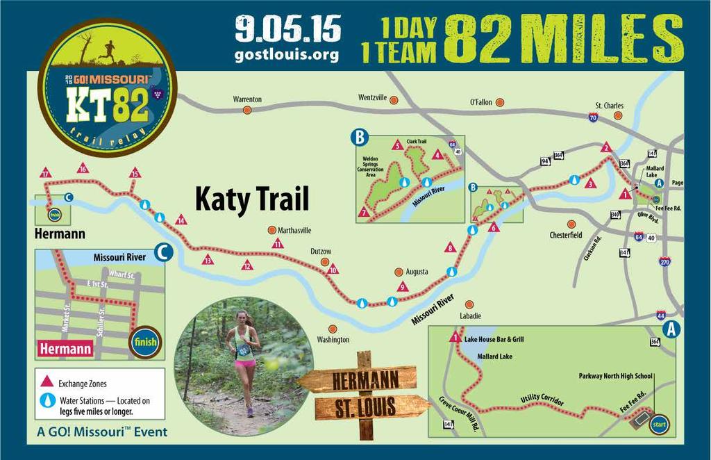
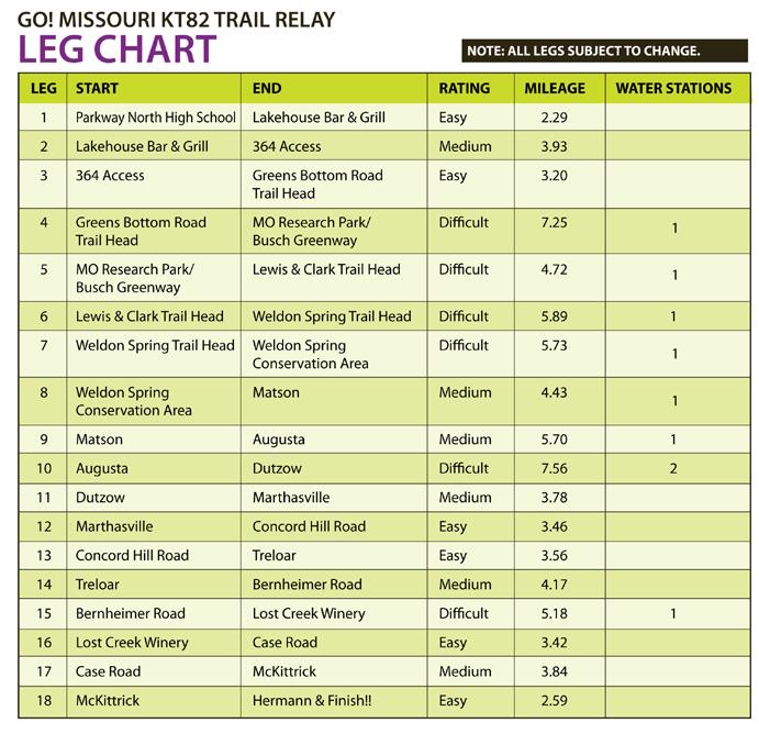
Driving Directions & Exchange Point Information
|
|
|
- Aileen Kennedy
- 5 years ago
- Views:
Transcription


1 Driving Directions & Exchange Point Information race day contacts In case of emergency, dial 911. For urgent KT82 questions, please contact GO! St. Louis staff at or
2 1
3 2

4 OVERVIEW of PARKWAY NORTH HIGH SCHOOL AREA Parkway North High School Fee Fee Road, HOST HOTEL Drury Hotel, Olive Boulevard, APPROACH ROUTES to START 270 to Olive West to Fee Fee Road to Parkway North 141 to Olive East to Fee Fee Road to Parkway North 364 to Bennington Place South to Fee Fee Road West to Parkway North 3

5 PARKWAY NORTH HIGH SCHOOL, Start of the KT82 Trail Relay Parkway North High School Fee Fee Road, Start 4

6 CHECK IN & PARKING Parking Parkway North High School Check in & Support Vehicle Inspection Parking Start REST ROOMS Proceed to Check in & Support Vehicle Inspection Station Ample Parking Available KT82 Start Line on Track 5

7 DRIVING DIRECTIONS, LEG 1. PARKWAY NORTH HIGH SCHOOL to LAKEHOUSE BAR & GRILL START DIRECTIONS Left on Fee Fee Road,.8 miles Right on Olive,.6 miles Right on Creve Coeur Mill Road, 1.5 miles Right in to Lakehouse Bar & Grill Parking Approximate Driving Time = 5 Minutes RUN ROUTE = 2.29 Miles Parkway North Track Cross Fee Fee Road Cross Bookbinder To Exchange 1 6

8 EXCHANGE 1, LAKEHOUSE BAR & GRILL Lakehouse Bar & Grill Support Vehicle Parking 7

9 DRIVING DIRECTIONS, LEG 2. LAKEHOUSE BAR & GRILL to 364 ACCESS 364 ACCESS EXCHANGE 2 DIRECTIONS = Right on Creve Coeur Mill Road, 1.8 mile Left on 141 / Maryland Heights Expressway, 1.1 miles Right on 364 West, 2.5 miles Exit 14 toward S. River Road,.4 miles Right on S. River Road and immediate Right on Hemsath Road,.3 Miles Right in to 364 Access Parking Lot RUN ROUTE = 3.93 Miles Leave Lakehouse exchange Left on Katy Trail connector Cross 364 Bridge To Exchange 2 Approximate driving time = 9 minutes 8

10 EXCHANGE 2, 364 ACCESS Support Vehicle Parking 9

11 DRIVING DIRECTIONS, LEG ACCESS to GREENS BOTTOM ROAD TRAIL HEAD 364 ACCESS X GREENS BOTTOM ROAD TRAIL HEAD EXCHANGE 3 DIRECTIONS = Right on S. River Road,.1 miles Left on S. River Road / Arena Parkway, 2.2 miles S. River Road becomes Upper Bottom Road Left on Jungs Station Road,.6 miles CAUTION=TRAIL CROSSING!!! RUN ROUTE = 3.20 MILES Right hand turn on to Katy Trail Greens Bottom Road Crosses Trail To Exchange 3 Jungs Station Road becomes Greens Bottom Road Continue on Greens Bottom Road, 1.3 miles Left in to Greens Bottom Road Trail Head for Exchange 3 Parking Approximate Travel Time = 8 minutes 10

12 EXCHANGE 3, GREENS BOTTOM ROAD Rest Rooms Support Vehicle Parking 11

13 Duckett 12

14 EXCHANGE 4, MISSOURI RESEARCH PARK / BUSCH GREENWAY Overflow SV Parking Support Vehicle Parking MEDICAL STATION 1 13

15 LEG 5, DRIVING DIRECTIONS. MISSOURI RESEARCH PARK / BUSCH GREENWAY to WELDON SPRING CONSERVATION AREA / LEWIS & CLARK TRAIL HEAD DIRECTIONS = Exit parking,.5 miles Right on Research Park Drive, 1.1 miles Left on 94 West, Miles Right Left at into sign Department for Weldon Spring of Energy Conservation parking Area / Lewis & Clark Trail Head Parking Approximate Driving Time = 9 minutes RUN ROUTE = 4.72 MILES Missouri Research Park trail Right on to Katy Trail Water Station at Mile 1.99 Right in to Weldon Spring Conservation Area Uphill and single track to Lewis & Clark Trail Head 14

16 EXCHANGE 5 OVERVIEW Parking Exchange 5 15

17 EXCHANGE 5 PARKING Support Vehicle Parking Pedestrian Crossing Exchange 5 Park in Support Vehicle Parking area. Cross Highway 94 on foot and proceed to Exchange 5 16

18 EXCHANGE 5, WELDON SPRING CONSERVATION AREA / LEWIS & CLARK TRAIL HEAD 17

19 LEG 6, DRIVING DIRECTIONS. WELDON SPRING CONSERVATION AREA / LEWIS & CLARK TRAIL HEAD to WELDON SPRING TRAIL HEAD DIRECTIONS = Left on 94 West, 2.7 miles Left to Weldon Spring Trail Head,.2 miles CAUTION!! TRAIL CROSSING!! Left in to Parking Approximate Driving Time = 6 minutes RUN ROUTE = 5.89 MILES Single Track & Downhill on the Clark Trail Right turn on to Katy Trail Water Station at Mile 3.28 To Exchange 6 18

20 EXCHANGE 6, WELDON SPRING TRAIL HEAD Rest Rooms Support Vehicle Parking MEDICAL STATION 2 19

21 LEG 7, DRIVING DIRECTIONS. WELDON SPRING TRAIL HEAD to WELDON SPRING CONSERVATION AREA DIRECTIONS = Right to exit parking CAUTION!! TRAIL CROSSING!! Continue for.2 Miles Left on to West 94,.7 miles CAUTION!! RUNNERS CROSSING ROAD!! Right in to Parking Approximate Driving Time = 4 minutes RUN ROUTE = 5.73 MILES Depart Exchange 6 Right on Hamburg Trail Water Station at 3.17 Miles Left on to Lost Valley Trail Connector Left on to Lost Valley Trail Follow Signs / Caution Tape to Exchange 7 20

22 EXCHANGE 7, WELDON SPRING CONSERVATION AREA Support Vehicle Parking EXCHANGE RULES = Support Vehicles approach exchange via Westbound Highway 94 Use Great Caution as Runners are running close to cones and also crossing Highway 94 Support Vehicles exit with right turn on to Westbound Highway 94 21

23 LEG 8, DRIVING DIRECTIONS. WELDON SPRING CONSERVATION AREA to MATSON X DIRECTIONS = Right on 94 West, 3.7 Miles (through Defiance) CAUTION!! TRAIL CROSSING!! Continue on 94 West,.9 miles Right on Matson Hill Road CAUTION!! TRAIL CROSSING!! Immediate Right in to Parking Approximate Driving Time = 8 minutes RUN ROUTE = 4.43 MILES Depart Exchange 7 Cross Highway 94 Right on to Hamburg Trail Right on Katy Trail Water Station at 2.53 Miles To Exchange 8 22

24 EXCHANGE 8, MATSON Support Vehicle Parking Rest Room EXCHANGE RULES = Support Vehicles approach via Westbound Highway 94 and a Right turn on Matson Hill Road Support Vehicles must exit parking with a Right on Matson Hill Road to Exchange 9 23

25 LEG 9, DRIVING DIRECTIONS. MATSON to AUGUSTA X DIRECTIONS = Right on Matson Hill Road, 1.2 Miles Left on Duke Road, 3.7 miles Bear Left on to Schluersburg Road,.9 miles Right on to 94 West,.7 miles Left on Church Road,.4 miles Right on Hackmann Road,.1 miles Left on Lower Street,.2 miles RUN ROUTE = 5.70 MILES Depart Exchange 8 Highway 94 Crosses Trail Water Station at Mile 2.19 To Exchange 9 Right on Main Street,.1 miles Left on Public Street Right or Left in to Parking Approximate Driving Time = 21 minutes 24

26 EXCHANGE 9, AUGUSTA Support Vehicle Parking Rest Rooms 25

27 LEG 10, DRIVING DIRECTIONS. AUGUSTA to DUTZOW DIRECTIONS = North on Public Street Left on Main Street,.1 miles Right on Jackson Street,.7 miles Left on to 94 West, 7.3 miles Left turn to stay on 94 West,.3 miles Right in to Parking Approximate Driving Time = 14 minutes RUN ROUTE = 7.56 MILES Depart Exchange 9 Water Station at Mile 2.20 Water Station at Mile 4.07 Highway 94 Crossing Exchange 10 26

28 EXCHANGE 10, DUTZOW Rest Rooms Support Vehicle Parking EXCHANGE RULES = Support Vehicles approach via Westbound 94 Support Vehicles Exit via Eastbound 94 27
, 2 miles Bluff Becomes Loop Road Continue Straight at Stop Sign to Boone Monument Road,.9 miles Left on Highway D, 1.")
29 LEG 11, DRIVING DIRECTIONS. DUTZOW to MARTHASVILLE DIRECTIONS = Left on 94 East,.2 miles Left on Bluff Road (at First Bank), 2 miles Bluff Becomes Loop Road Continue Straight at Stop Sign to Boone Monument Road,.9 miles Left on Highway D, 1.1 miles Highway D becomes Main Street RUN ROUTE = 3.78 MILES Depart Exchange 10 Boone Monument Road Crosses Trail 1 Street / Highway D Crosses Trail To Exchange 11 Left on 1 Street,.1 miles Right on Depot Street and Immediate left in to Parking Approximate Driving Time = 11 minutes 28

30 EXCHANGE 11, MARTHASVILLE Fuel Support Vehicle Rest Parking Rooms MEDICAL STATION 3 EXCHANGE RULES = Support Vehicles Approach via Southbound Highway D Support Vehicles Exit via a Left on to Depot Street FUEL = Fuel is available adjacent to Exchange 11 or on Highway 19 North of Marthasville 29

31 LEG 12, DRIVING DIRECTIONS. MARTHASVILLE to CONCORD HILL ROAD DIRECTIONS = Left on Depot Street,.2 miles Right on 5th Street,.1 miles Left on West South Street,.1 miles Left on to Highway 47,.2 miles RUN ROUTE = 3.46 MILES Depart Exchange 11 To Exchange 12 Right on 94 West, 3.2 miles Right on Concord Hill Road CAUTION!! TRAIL CROSSING!! Straight to parking Approximate Driving Time = 7 minutes 30

32 EXCHANGE 12, CONCORD HILL ROAD To Exchange 13 Support Vehicle Parking Support Vehicle Parking EXCHANGE RULES = Support Vehicles approach from 94 West to Concord Hill Road Support Vehicles MUST depart via Concord Hill Road North Support Vehicles should park facing exit on Concord Hill Road 31

33 LEG 13, DRIVING DIRECTIONS. CONCORD HILL ROAD to TRELOAR DIRECTIONS = Exit via Concord Hill Road North, 3.7 miles Concord Hill Road becomes Mill Road Left on Highway N, 1.3 miles Left on Koch Creek Road,.1 miles RUN ROUTE = 3.56 MILES Depart Exchange 12 Koch Creek Road Crosses Trail To Exchange 13 Right on Market Street and Left to Parking Approximate Driving Time = 13 minutes 32

34 EXCHANGE 13, TRELOAR Support Vehicle Parking Rest Room EXCHANGE RULES = Support Vehicles approach via Highway N 33
,.2 Miles CAUTION!! TRAIL CROSSING!! Continue on Bernheimer Road,.6 miles Approximate Driving Time = 8 Minutes RUN ROUTE = 4.")
35 LEG 14, DRIVING DIRECTIONS. TRELOAR to BERNHEIMER ROAD DIRECTIONS = Right on Market Street Right on Koch Creek Road,.1 Miles CAUTION!! TRAIL CROSSING!! Right on 94, 2.9 Miles CAUTION!! TRAIL CROSSING!! Continue on 94,.2 Miles Left on Bernheimer Road (at Quarry Sign),.2 Miles CAUTION!! TRAIL CROSSING!! Continue on Bernheimer Road,.6 miles Approximate Driving Time = 8 Minutes RUN ROUTE = 4.17 MILES Leave Exchange 13 Highway 94 crosses trail Bernheimer Road crosses trail Exchange 14 34

36 EXCHANGE 14, BERNHEIMER ROAD X X EXCHANGE RULES = Support Vehicles approach exchange point via Bernheimer Road Westbound. Support Vehicles exit by continuing West on Bernheimer toward Exchange 15 35

37 LEG 15, DRIVING DIRECTIONS. BERNHEIMER ROAD to LOST CREEK VINEYARD DIRECTIONS = Continue on Bernheimer Road CAUTION!! TRAIL CROSSING!! Continue on Bernheimer Road, 2.2 miles Right to continue on Bernheimer Road Left on 94, 3.9 miles Left on Gore Road at Lost Creek Vineyard sign,.3 miles RUN ROUTE = 5.18 MILES Depart exchange 14 Water Station at Mile 2.80 Right turn on Gore Road Exchange 15 Left in to Lost Creek Vineyard Parking Approximate Driving Time = 13 minutes 36

38 EXCHANGE 15, LOST CREEK VINEYARD Support Vehicle Parking Lost Creek Vineyard Support Vehicle Parking EXCHANGE RULES = Support Vehicles approach via Gore Road, enter Lost Creek Vineyard only at Enter sign 37

39 LEG 16, DRIVING DIRECTIONS. LOST CREEK VINEYARD to CASE ROAD DIRECTIONS = Right on Gore Road,.2 miles Left on West 94, 3.5 miles Right on Case Road,.1 miles Approximate Driving Time = 6 minutes RUN ROUTE = 3.42 MILES Leave exchange 15 Right turn on Katy Trail Highway 94 Crosses Trail To Exchange 16 38

40 EXCHANGE 16, CASE ROAD EXCHANGE RULES = Support Vehicles approach via Highway 94 Westbound and turn on to Case Road To exit, Support Vehicles continue Westbound on Case Road toward Exchange 17 39

41 LEG 17, DRIVING DIRECTIONS. CASE ROAD to McKITTRICK X X DIRECTIONS = Continue on Case Road, 1.8 miles Bear Left to remain on Case Road,.6 miles CAUTION!! TRAIL CROSSING!! Continue on Case Road,.1 miles Right on 94, 2.1 miles Right on McKittrick Road,.4 miles RUN ROUTE = 3.84 MILES Leave Exchange 16 Case Road Crossing McKittrick Road Crosses Trail To Exchange 17 CAUTION!! TRAIL CROSSING!! Left on Sterline Street,.1 miles Left in to Parking Approximate Driving Time = 12 minutes 40

42 EXCHANGE 17, McKITTRICK Support Vehicle Parking Rest Room EXCHANGE RULES = Support Vehicles approach via Sterline Street Support Vehicles MUST exit via Left turn out of Trail Head on to Sterline Street 41

43 LEG 18, DRIVING DIRECTIONS. McKITTRICK to HERMANN & FINISH DIRECTIONS = Left on Sterline Street Left on Main Street,.3 miles Left on Highway 19, 2.3 miles CAUTION!! RUNNERS on RIGHT SHOULDER!! Cross Bridge in to Hermann Left on 3rd, 4th or 5th Street,.2 miles Park & Join your finishing runner on Gutenberg Street for TEAM FINISH! Approximate Driving Time = 9 minutes RUN ROUTE = 2.59 Miles Leave Exchange 17 Under Highway 19 then Left Turn to Highway 19 Shoulder Cross Missouri River Left on 2nd Street Right on Gutenberg Street FINISH!! 42

44 LEG 18, HERMANN & FINISH FINISH Amphitheater MEDICAL STATION 4 Support vehicles approach Finish via Highway 19 / Market Street. Left turn on to 3rd, 4th or 5th to find parking Teams are encouraged to join Leg 18 runner on Gutenberg for a TEAM FINISH!!!! 43
45 KT82 Official Sponsor
2016 VEHICLE SUPPORT GUIDE
 2016 VEHICLE SUPPORT GUIDE DRIVING DIRECTIONS & ECHANGE POINT INFORMATION RACE DAY CONTACT In case of emergency, dial 911. For urgent KT82 questions, please contact GO! St. Louis staff at 314-477-9427
2017 VEHICLE SUPPORT GUIDE
 2017 VEHICLE SUPPORT GUIDE DRIVING DIRECTIONS & EXCHANGE POINT INFORMATION RACE DAY CONTACT In case of emergency, dial 911. For urgent KT82 questions, please contact GO! St. Louis staff at 314-477-9427
PARTICIPANT RACE GUIDE
 PARTICIPANT RACE GUIDE JUNE 3, 20 The GO! Missouri TM KT82 participant guide is the exclusive property of GO! St. Louis and may not be copied, duplicated or edited in any manner without the written permission
Rock Road Transit. Northwest Plaza. Charles Rock Rd. Shopping Center Woodson & St. Center
 35 Rock Road - Monday thru Friday EASTBOUND Effective: November 26, 2018 & Valley Industries 5:01A 5:07A 5:17A 5:28A 5:23A 5:30A 5:40A 5:51A 5:47A 5:54A 6:04A 6:16A 5:35A 5:41A 5:51A 5:58A 6:10A 6:17A
PART #1 ALTON, IL TO MACHENS, MO
 The TransAm Eastern Express - Westbound Map Set #18A Alton, IL to Augusta, MO (via Clark Bridge) 52.0 Miles / Cumulative Climbing: 780 PART #1 ALTON, IL TO MACHENS, MO CYCLING NARRATIVE: 0.0 Leaving Alton
Institute for Real Estate Management Chapter (IREM) 77 VDOT Northern Virginia Megaprojects September 13, 2017
 77 VDOT Northern Virginia Megaprojects September 13, 2017") Institute for Real Estate Management Chapter (IREM) 77 VDOT Northern Virginia Megaprojects September 13, 2017 Susan Shaw, P.E., Megaprojects Director Virginia Department of Transportation Northern Virginia
Institute for Real Estate Management Chapter (IREM) 77 VDOT Northern Virginia Megaprojects September 13, 2017 Susan Shaw, P.E., Megaprojects Director Virginia Department of Transportation Northern Virginia
About The Big Bend Open Road Race U.S 285 Course Notes
 2018 About The Big Bend Open Road Race U.S 285 Course Notes Course notes for 2018, Ft. Stockton to Sanderson and return. * Please note that these course notes are based on the 2017 race. You will notice
EXHIBIT B-1 PROJECT DESCRIPTION. Phase 1 of the Preferred Alternative
 EXHIBIT B-1 PROJECT DESCRIPTION Phase 1 of the Preferred Alternative The Transform 66 Public-Private Partnership (P3) Project (the Project ) means the Phase 1 of the Preferred Alternative components of
Leg Map & Elevation Profile. Finish Address: 1913 Highway 402 Huger, SC
 Palmetto70 Relay - Leg #1 Distance: 2.80 Miles Start: Witherbee Ranger Station Rating: Easy Finish: Huger Rec Area GPS Coordinates for Finish: Lat: 33.135 Lon: -79.811 Finish Address: 1913 Highway 402
Durrance Elementary School
 Durrance Elementary School SCHOOL ROUTE PLAN For DURRANCE ELEMENTARY SCHOOL LOCATION 9 ORANGE COUNTY Prepared for: ORANGE COUNTY SCHOOL ASSESSMENT PROGRAM ORANGE COUNTY PUBLIC WORKS Traffic Engineering
APPENDIX D COST SUMMARY TABLES
 APPENDIX D COST SUMMARY TABLES Section 1 Between Route 50 and Evergreen Mills Road 3850 linear feet of one 12 foot wide additional lane in southbound direction of Rte 606; from north side of Rte 50 to
2017 Relay Team Handbook
 2017 Relay Team Handbook Race Date: April 23, 2017 (Updated 4/05/17) PRESENTED BY Welcome to the Mt. Si Relay 2017 This booklet contains important information for the 34th Annual Mt. Si Relay, April 23,
TRAFFIC ALERT FOR FEBRUARY 26 to MARCH 2, 2018 Highway Work Zones in the Staunton District
 RELEASE: IMMEDIATE February 23, 2018 CONTACT: Sandy Myers 540-332-9201 (office) STA18-039 540-292-2500 (cell) Sandy.Myers@VDOT.virginia.gov Ken Slack 540-332-9264 (office) 540-414-5670 (cell) Ken.Slack@VDOT.virginia.gov
BRR Leg 25 (4.3 miles, Moderate)
") BRR Leg 25 (4.3 miles, Moderate) Min 2290 Max 2492 Ascent +287 Descent -244 0.0 EZ 24 (Bakersville Fire Dept.) 0.0 Cross bridge 0.0 L Route 226 4.3 Red Hill Baptist Church, on L (EZ 25) Leg Notes: 226
BRR Leg 25 (4.3 miles, Moderate) Min 2290 Max 2492 Ascent +287 Descent -244 0.0 EZ 24 (Bakersville Fire Dept.) 0.0 Cross bridge 0.0 L Route 226 4.3 Red Hill Baptist Church, on L (EZ 25) Leg Notes: 226
Description: Widen I-64 to 6 lanes from I-265 to the KY 53 interchange in Shelby County.
 I-64 KIPDA ID # 350 Project Type: ROADWAY CAPACITY Description: Widen I-64 to 6 lanes from I-265 to the KY 53 interchange in Shelby County. Purpose: Project will improve capacity and address safety concerns.
Important Lane Closures for Jan , 2012
 Jan. 19, 2011 CONTACT: Marcia McAllister T: 703-572-0506 C: 571-730-9117 marcia.mcallister@dullesmetro.com Important Lane Closures for Jan. 22-28, 2012 Bridge Construction along Median of Route 7 Continues,
Swamp Road Residents Study
 Swamp Road Residents Study SRRG Meeting with PennDot and Elected Officials Newtown and Wrightstown, PA April 25, 2008 Newtown Township Section of Swamp Road Limited Public Funds No reconstruction of a
OCEAN TO SOUND RELAY SEPTEMBER 25, 2016 COURSE DESCRIPTION LEG 1
 GENERAL DESCRIPTION: 5.9 MILES--ALL FLAT START: JONES BEACH STATE PARK FIELD #2 FINISH: CEDAR CREEK PARK (SEAFORD) OCEAN TO SOUND RELAY LEG 1 0.0 miles START ON BOARDWALK AT EAST END OF JONES BEACH PARKING
Terwillegar Drive Expressway Draft Concept Plan
 Terwillegar Drive Expressway Draft Concept Plan Anthony Henday Drive to Whitemud Drive November 28 5:00-8:00 p.m. December 1 10:00 a.m. - 3:00 p.m. Let s Talk Today you can: Learn about the new direction
FDOT Treasure Coast Traffic Impact Report
 February 10, 2017 Chuck McGinness, 954 777 4302 chuck.mcginness@dot.state.fl.us FDOT Treasure Coast Traffic Impact Report February 10 through February 17, 2017 TREASURE COAST Construction and maintenance
FDOT Treasure Coast Traffic Impact Report April 7 through April 14, 2017
 April 7, 2017 Chuck McGinness, 954 777 4302 chuck.mcginness@dot.state.fl.us FDOT Treasure Coast Traffic Impact Report April 7 through April 14, 2017 TREASURE COAST Construction and maintenance related
Fish Lake Team Relay Course Information 2016
 Fish Lake Team Relay Course Information 2016 Fish Lake Team Relay Course Information 2016 The Fish Lake Team Relay begins at Fish Lake Lodge on the shores of beautiful Fish Lake located in Sevier County,
2017 Temple to Temple Relay Race Bible
 Brigham Young University-Idaho Student Activities 2017 Temple to Temple Relay Race Bible (As of May 25, 2017) The Temple to Temple Relay is a team running event that starts at the church immediately west
City of Fairfax, Virginia City Council Work Session
 City of Fairfax, Virginia City Council Work Session Agenda Item # City Council Meeting 12a 9/8/2015 TO: FROM: SUBJECT: ISSUE(S): SUMMARY: FISCAL IMPACT: RECOMMENDATION: ALTERNATIVE COURSE OF ACTION: RESPONSIBLE
OTO BIKE/PED PLAN REPORT
 OTO BIKE/PED PLAN REPORT 6/30/2012 Implementation in FY2012 This report outlines the bike/ped accomplishments related to the OTO Bike/Ped Plan. Activities occurring during the 2012 Fiscal Year, July 1,
PUBLIC INFORMATION MEETING
 PUBLIC INFORMATION MEETING Bridge Rehabilitation Project Project Identification Number 5134.45 NY Route 5 Buffalo Skyway I-190 North Ramp, Pearl Street Ramp Wednesday, April 18, 2018 4:00 p.m. to 7:00
Feasibility Study of Pedestrian Crossings Along Route 7, East of Cascades Parkway and West of Dranesville Road. October 3, 2017
 Feasibility Study of Pedestrian Crossings Along Route 7, East of Cascades Parkway and West of Dranesville Road October 3, 2017 Study Area (area within a ¼-mile radius of the study intersections) Route
Fish Lake Team Relay Course Information
 Fish Lake Team Relay Course Information Fish Lake Team Relay Course Information The Fish Lake Team Relay begins at Fish Lake Lodge on the shores of beautiful Fish Lake located in Sevier County, Utah. The
3.5 Preferred Design Description of LRT/Road Layout, Stops and Stations
 3.5 Preferred Design Description of LRT/Road Layout, Stops and Stions The following section includes a detailed description of LRT/ road layout (including special cross-sections), bridge modificions, and
2017 TIR Driver Directions & Instructions Important Notes:
 2017 TIR Driver Directions & Instructions Important Notes: We suggest having this document, the event maps (online or printed out), a GPS device (and its charger), the exchange coordinates, and a regular
Multi-Modal Traffic Analysis. Parisi and Associates
 Mill Valley to Corte Madera Bicycle and Pedestrian Corridor Study Appendix D: Multi-Modal Traffic Analysis Prepared by Parisi and Associates August 2009 Appendix D - Multi-Modal Traffic Analysis Table
Road Construction Summary Report
 Road Construction Summary Report New Location Description Impacts When Est. Completion Date Delay Church St/ROUTE - 952G Eastbound/Westbound ramp to Route 5 Westbound City Ramp will be closed From 6pm
9 th Annual. And Youth Super Sprint. August 27, Proceeds to benefit: FAMILIES OF THE WOUNDED FUND
 9 th Annual And Youth Super Sprint August 27, 2017 Proceeds to benefit: FAMILIES OF THE WOUNDED FUND Sprint Triathlon: $65 per person (Add $10 after August 7); $110 for relay team of 3 persons (Add $10
FDOT Treasure Coast Traffic Impact Report
 January 20, 2017 Chuck McGinness, 954 777 4302 chuck.mcginness@dot.state.fl.us FDOT Treasure Coast Traffic Impact Report January 20 through January 27, 2017 TREASURE COAST Construction and maintenance
USBR 21 KNOXVILLE TO CHATTANOOGA ROUTE MILE TURNS ROADS
 USBR 21 KNOXVILLE TO CHATTANOOGA ROUTE MILE TURNS ROADS 0.0 L SS Hill Rd 0.3 L SL S Gay Street 0.6 R SL E Blount Ave - stay S at SL 2.2 L SL Maryville Pike 2.3 R SS Martin Mill Pike 4.0 L Neubert Springs
FDOT Treasure Coast Traffic Report
 July 6, 2018 Barbara Kelleher, 954 777 4090 Barbara.Kelleher@dot.state.fl.us FDOT Treasure Coast Traffic Report July 6 through July 13, 2018 TREASURE COAST Construction and maintenance related lane closures
MARCH 2005 PERFORMANCES DRIVING DIRECTIONS
 All dancers must arrive (generally) 30 minutes before performance time as noted after each performance location and wait quietly before dancing. Dancers who do not arrive on time for a performance may
Highway 169 Mobility Study Technical Advisory Committee Meeting #9 Meeting Record
 Highway 169 Mobility Study Technical Advisory Committee Meeting #9 Meeting Record Thursday, May 25, 2017 8:30-10:30 a.m. City of Eden Prairie Heritage Rooms I and II Attendees Brad Larsen, MnDOT Angie
High Country Rural Planning Organization (RPO) Municipalities and Counties of Alleghany, Ashe, Avery, Mitchell, Watauga, Wilkes, and Yancey
 Municipalities and Counties of Alleghany, Ashe, Avery, Mitchell, Watauga, Wilkes, and Yancey") High Country Rural Planning Organization (RPO) Municipalities and Counties of Alleghany, Ashe, Avery, Mitchell, Watauga, Wilkes, and Yancey Serving North Carolina s High Country with Continuing, Cooperative,
High Country Rural Planning Organization (RPO) Municipalities and Counties of Alleghany, Ashe, Avery, Mitchell, Watauga, Wilkes, and Yancey Serving North Carolina s High Country with Continuing, Cooperative,
Los Altos Hills Town Council - June 18, 2015 Palo Alto City Council June 22, AGENDA ITEM #2.B Presentation
 Los Altos Hills Town Council - June 18, 2015 Palo Alto City Council June 22, 2015 AGENDA ITEM #2.B Presentation Previous Presentations Los Altos Hills Town Council in May 2014 and February 2015 Palo Alto
FEDEX GROUND PITTSBURGH MARATHON RELAY HANDBOOK
 FEDEX GROUND PITTSBURGH MARATHON RELAY HANDBOOK The FedEx Ground Pittsburgh Marathon Relay course is the same as the DICK S Sporting Goods Pittsburgh Marathon course. The 2-5 person relay offers a distance
Exhibit C 2018 Wasatch Back Ragnar Relay Analysis
 Event Description The 2018 Wasatch Back Ragnar Relay is a 200 mile race, run by teams of 12 runners that starts in Logan, Utah and finishes in Kamas, Utah, June 1-2, 2018. The Wasatch Back Ragnar Relay
Harrah s Station Square Casino
 Transportation Analysis Harrah s Station Square Casino Pittsburgh, Pennsylvania Submitted To: City of Pittsburgh and Pennsylvania Gaming Control Board Prepared By: DKS Associates GAI Consultants December
Iowa Highway 58 Corridor Improvement Study
 1 Iowa Highway 58 Corridor Improvement Study Public Informational Meeting May 6, 2014 2 Welcome and Introductions Randy Lorenzen, City of Cedar Falls Engineer 3 Outline of Presentation Review of Project
2017 Crew Manual Alternate Route Race Day - February 18, 2017
 2017 Crew Manual Alternate Route Race Day - February 18, 2017 Crew Rules Crewing is a privilege not a right at this race. We ask that you follow these simple rules to help keep our race safe and enjoyable
Meeting Schedule 7:00-7:15 Open House 7:15-7:45 Existing Conditions/Short-Term Improvements Study Presentation 7:45-8:00 Q&A Session 8:00-8:10
 Meeting Schedule 7:00-7:15 Open House 7:15-7:45 Existing Conditions/Short-Term Improvements Study Presentation 7:45-8:00 Q&A Session 8:00-8:10 Long-Term Study Presentation 8:10-8:40 Table Discussions 8:40-9:00
Race Weekend Instructions
 Race Weekend Instructions Thank You for registering for the Surfer s Path Marathon, Capitola Half Marathon or Capitola Half Marathon Relay. We re excited to bring you this event that showcases the Santa
VDOT I-66 Inside the Beltway Eastbound Widening Environmental Assessment. Staff Recommendations
 VDOT I-66 Inside the Beltway Eastbound Widening Environmental Assessment Staff Recommendations Department of Environmental Services Transportation January 28, 2017 Timeline of Transform66 June 2012: I-66
AGENDA ITEM 6 D THOMASVILLE ROAD (HERMITAGE BOULEVARD TO LIVE OAK PLANTATION ROAD) ROADWAY SAFETY AUDIT
 ROADWAY SAFETY AUDIT") May 15, 2018 AGENDA ITEM 6 D THOMASVILLE ROAD (HERMITAGE BOULEVARD TO LIVE OAK PLANTATION ROAD) ROADWAY SAFETY AUDIT TYPE OF ITEM: Discussion STATEMENT OF ISSUE The Florida Department of Transportation
May 15, 2018 AGENDA ITEM 6 D THOMASVILLE ROAD (HERMITAGE BOULEVARD TO LIVE OAK PLANTATION ROAD) ROADWAY SAFETY AUDIT TYPE OF ITEM: Discussion STATEMENT OF ISSUE The Florida Department of Transportation
PRIORITIES RESULTS YOUR PRIORITIES FOR BRIDGEPORT 5% 4% 13% RESIDENTIAL CHOICES TRAILS & PARKS
 Community Visioning Open House The Community Visioning Open House was held on January, 31st 2018 at Harrisburg Area Community College (HACC), Lancaster Campus. Approximately 80 people attended this Open
Appendix C. NORTH METRO STATION AREA TRAFFIC IMPACT STATEMENT 88th Avenue Station
 Appendix C NORTH METRO STATION AREA TRAFFIC IMPACT STATEMENT 88th Avenue Station Prepared for: Regional Transportation Department and URS Corporation as part of the North Metro EIS David Evans and Associates,
I-215 / NEWPORT ROAD INTERCHANGE PROJECT PRESS KIT
 I-215 / NEWPORT ROAD INTERCHANGE PROJECT PRESS KIT March I-215 / NEWPORT ROAD INTERCHANGE PROJECT Fact Sheet Project Overview This project will reconstruct the existing interchange located on Interstate
Some streets and highways will be closed to vehicular traffic during the 2015 Road World Championships. While
 Some streets and highways will be closed to vehicular traffic during the 2015 Road World Championships. While some closures last the entire duration of the 2015 Worlds, most will occur daily to accommodate
Access Routes from US 101 to the Richmond San Rafael Bridge
 Access Routes from US 101 to the Richmond San Rafael Bridge TAM Board Meeting January 28, 2016 RSRB Project Elements Eastbound Third Lane: Sir Francis Drake Blvd. to Marine Street 10 ft Barrier Separated
Foothill Expressway Improvements Between El Monte and San Antonio
 Foothill Expressway Improvements Between El Monte and San Antonio June 29, 2017 - Los Altos Community Meeting Introduction Project Background Agenda Visit Stations: Provide Input and Ask Questions Reconvene:
Stakeholder Focus Group Meeting #3 January 9, 2013 Cattlemens, 2000 Taylor Road, Roseville
 PRESENT Stakeholder Focus Group Meeting #3 January 9, 2013 Cattlemens, 2000 Taylor Road, Roseville PROJECT TEAM REPRESENTATIVES Name Organization Celia McAdam Luke McNeel Caird Leo Heuston Judy Matsui
POLICY ADVISORY COMMITTEE
 September 27, 2018 POLICY ADVISORY COMMITTEE ENVIRONMENTAL ANALYSIS PHASE Agenda 1. Welcome and introductions. 2. Overview of project activities and process. 3. Public engagement update. 4. Community Advisory
29 th Annual Army Spring Classic United States Military Academy
 29 th Annual Army Spring Classic United States Military Academy West Point, New York April 13 th and 14 th 2013 Pre-Registration: *Register at Bike Reg.com (Preferred method).* E-Mail: Jennifer.Webster@usma.edu
I-264 CORRIDOR EVALUATION STUDY. September 7, 2016 Eric Stringfield VDOT Planning Director Chris Lawrence AECOM Senior Transportation Engineer
 I-264 CORRIDOR EVALUATION STUDY September 7, 2016 Eric Stringfield VDOT Planning Director Chris Lawrence AECOM Senior Transportation Engineer Study Overview Interchange Locations Study Context Follow-up
Figure 1: East West Connector Alignment Alternatives Concept Drawing
 Page 2 of 9 Figure 1: East West Connector Alignment Alternatives Concept Drawing The Montebello Drive extension will run north south and connect Wilsonville Road to the Boones Ferry Road to Brown Road
Directions to Competition Venues:
 Directions to Competition Venues: VILLANOVA UNIVERSITY LDR/W, Powerlifting, Soccer (Individual Skills, 7v7, 11v11), Volleyball 800 Lancaster Avenue, Villanova, PA, 19085 From the West Take the Pennsylvania
2014/2015 BIKE ROUTE PLAN 83 AVENUE PROTECTED BIKE LANE
 About the Project 2014/2015 BIKE ROUTE PLAN The City of Edmonton is planning a major bike route on the south side of Edmonton. This bike route is one part of a plan to provide citizens with transportation
Banff-Jasper Relay Course Description March 17, 2005
 Banff-Jasper Relay Course Description March 17, 2005 The course description is general, although the distances are reasonably precise. The object is to give teams a sense of the conditions they will meet
DAFFODIL FESTIVAL 2018 STREET PARADE BANDS & LARGE MARCHING UNITS USING BUSES (SU#5)
") DAFFODIL FESTIVAL 2018 STREET PARADE BANDS & LARGE MARCHING UNITS USING BUSES (SU#5) The Parade will start at: 10:15 a.m. in Tacoma 2:30 p.m. in Sumner 12:45 p.m. in Puyallup 5:00 p.m. in Orting MARCHERS:
DAFFODIL FESTIVAL 2018 STREET PARADE BANDS & LARGE MARCHING UNITS USING BUSES (SU#5) The Parade will start at: 10:15 a.m. in Tacoma 2:30 p.m. in Sumner 12:45 p.m. in Puyallup 5:00 p.m. in Orting MARCHERS:
Gravel Bike Guide Haywood County
 Gravel Bike Guide Haywood County Haywood County is an ideal place for bicycling on gravel roads, because 37% or 129,994 acres of Haywood County is federal property, including portions of the Pisgah National
ELK VALLEY ULTRA RACER HANDBOOK PRESENTED BY STAG LEAP RUNNING CO. JULY 29, 2017 FERNIE, BC
 ELK VALLEY ULTRA RACER HANDBOOK JULY 29, 2017 FERNIE, BC PRESENTED BY STAG LEAP RUNNING CO. TABLE OF CONTENTS WELCOME PAGE 3 GETTING READY PAGES 3 4 o Accommodation Discounts o Can t Race? o Change to
Highway 49, Highway 351 and Highway 91 Improvements Feasibility Study Craighead County
 Highway 49, Highway 351 and Highway 91 Improvements Feasibility Study Craighead County Executive Summary March 2015 Highway 49, Highway 351 and Highway 91 Improvements Feasibility Study Craighead County
Vehicular and Pedestrian Access to Herndon Metrorail Station. Robert B. Boxer, Director John Stuart, Clark Nexen October 28, 2015
 Vehicular and Pedestrian Access to Herndon Metrorail Station Robert B. Boxer, Director John Stuart, Clark Nexen Project Location The project is located in the Town of Herndon along Herndon Parkway between
Southwestern RPO Prioritization Local Input Points for Division Needs Funding
 H172327 US 19 Business paved shoulders; include bicycle lanes and sidewalks. Location: extends 0.9 miles from Junaluska Road in Andrews to US 19/74. $ 6,100,000 9.20 H090251-AC R-3622AC NC 294 (southern
Trail and Driving Directions
 Trail and Driving Directions GETTING TO THE START: FROM CADILLAC: Follow M-55 west from US131 for 20.9 miles to the corner of M-37 and M-55 FROM THE INTERSECTION OF M-55 AND M-37: Head west on M-55 2.7
May 10, 2013 Meredith Cruz, (561) Palm Beach County Traffic Report May 10 through May 17, 2013
 Palm Beach County Traffic Report May 10 through May 17, 2013") May 10, 2013 Meredith Cruz, (561) 641-6440 mcruz@corradino.com Palm Beach County Traffic Report May 10 through May 17, 2013 Palm Beach County Palm Beach County traffic will be affected this week by ongoing
May 10, 2013 Meredith Cruz, (561) 641-6440 mcruz@corradino.com Palm Beach County Traffic Report May 10 through May 17, 2013 Palm Beach County Palm Beach County traffic will be affected this week by ongoing
CANMORE ROAD TRIATHLON
 CANMORE ROAD TRIATHLON PARTICIPANT GUIDE SUNDAY, SEPTEMBER 02, 2018 The important race information contained within this document will be crucial for ensuring a safe and memorable race experience for all
FDOT Treasure Coast Traffic Report
 July 13, 2018 Barbara Kelleher, 954 777 4090 Barbara.Kelleher@dot.state.fl.us FDOT Treasure Coast Traffic Report July 13 through July 20, 2018 TREASURE COAST Construction and maintenance related lane closures
FDOT Treasure Coast Traffic Impact Report
 September 29, 2017 Chuck McGinness, 954 777 4302 chuck.mcginness@dot.state.fl.us FDOT Treasure Coast Traffic Impact Report September 29 through October 6, 2017 TREASURE COAST Construction and maintenance
Staunton. Transportation Plan. Transportation Planning Division. Virginia Department of Transportation
 2020 Transportation Plan Developed for the Transportation Planning Division of the Virginia Department of Transportation in cooperation with the U.S. Department of Transportation, Federal Highway Administration
2014/2015 BIKE ROUTE PLAN 83 AVENUE PROTECTED BIKE LANE
 About the Project The City of Edmonton is planning a major bike route on the southside of Edmonton. The Strathcona Bike Route will connect the communities of Strathcona, Garneau and the University area,
King Soopers #116 Thornton, Colorado
 Traffic Impact Study King Soopers #116 Thornton, Colorado Prepared for: Galloway & Company, Inc. 1.0 EXECUTIVE SUMMARY King Soopers #116, a grocery marketplace anchored commercial development, is proposed
Race Booklet.
 Race Booklet www.gorgeousseries.com GORGEOUS RUNNER REWARDS! 5% off a 2 nd relay in 2018 10% off a 3 rd 20% off a 4 th and 30% off your 5 th relay in 2018! Saturday, May 19 Gorgeous Portland Pub Relay
REDEVELOPMENT OPPORTUNITY! FOR SALE
 SALE PRICE: Contact Agent LOT SIZE: 0.31 Acres BUILDING SIZE: 2,830 SF YEAR BUILT: 1906 ZONING: CBD Central Business District CROSS STREETS: 2nd Street South PROPERTY OVERVIEW This offering is for the
Orange County Rail-Highway Grade Crossing Safety Enhancement Program. City of San Juan Capistrano April 17, 2012
 Orange County Rail-Highway Grade Crossing Safety Enhancement Program City of San Juan Capistrano April 17, 2012 Orange County Rail-Highway Grade Crossing Safety Enhancement Program (OCX) 52 crossings 8
Leg #1 (GUNLOCK AND LOADED) Miles
 Miles") Leg #1 (GUNLOCK AND LOADED)- 6.07 Miles Difficulty: Easy to Moderate This is a nice leg for those who like running downhill. It s a beautiful run down the Santa Clara River canyon to the point where the
Leg #1 (GUNLOCK AND LOADED)- 6.07 Miles Difficulty: Easy to Moderate This is a nice leg for those who like running downhill. It s a beautiful run down the Santa Clara River canyon to the point where the
Traffic Impact Study. Roderick Place Columbia Pike Thompson s Station, TN. Transportation Group, LLC Traffic Engineering and Planning
 F i s c h b a c h Transportation Group, LLC Traffic Engineering and Planning Traffic Impact Study Roderick Place Columbia Pike Thompson s Station, TN Prepared March 2016 Ms. Gillian L. Fischbach, P.E.,
Summary: Mercer County Princeton Avenue & Spruce Street Study January 2009
 Summary: Several recent studies have assessed potential development and redevelopment opportunities in the Mercer Crossing area of Trenton, Ewing, and Lawrence. This Princeton Avenue and Spruce Street
Legislative Update. Frederick County Fall Staunton District. Interstate 81 - Exit 300 at Interstate 66 Southbound Acceleration Lane Extension
 Interstate 81 - Exit 300 at Interstate 66 Southbound Acceleration Lane Extension Application ID 1643 Northern Shenandoah Valley Regional Commission (NSVRC) $3,437,423 This project extends the Interstate
To: Visiting Team. From: Craig Biggs, Associate Athletic Director for Operations
 TEAM HOST MANUAL To: Visiting Team From: Craig Biggs, Associate Athletic Director for Operations In an attempt to accommodate you and your team during your stay in Bowling Green, the WKU Team Host Manual
29th Running of the Ouachita Trail 50 Endurance Run April 13, 2019 Race Information
 29th Running of the Ouachita Trail 50 Endurance Run April 13, 2019 Race Information The Basics Location: Starting Time: Packets: Race Detail Maumelle Park, Little Rock, Arkansas, Pavilion # 8 (see map
Giles Run Connector Road
 Giles Run Connector Road Laurel Hill Adaptive Reuse Area to Laurel Crest Drive South County Federation Meeting June 14, 2016 History Connector road included in the Laurel Hill Comprehensive Plan amendment
Welcome to the Sellwood Bridge Project Open House!
 Welcome to the Sellwood Bridge Project Open House! 5:30 7:30 pm Please sign in here Information stations and project staff are located throughout the room. Goals for Tonight s Meeting: Learn how the Preferred
Mad Wolf Winter Relay Feb 25, 2017
 Mad Wolf Winter Relay Feb 25, 2017 All proceeds to benefit Big Sky Ski Education Foundation and the more than 200 kids who participate in ski racing. The Course: New this year! Alpine Leg: The race starts
Hidden Oaks Elementary School
 Hidden Oaks Elementary School SCHOOL ROUTE PLAN For HIDDEN OAKS ELEMENTARY SCHOOL LOCATION 13 ORANGE COUNTY Prepared for: ORANGE COUNTY SCHOOL ASSESSMENT PROGRAM ORANGE COUNTY PUBLIC WORKS Traffic Engineering
Army Spring Classic Stony Point and West Point, NY April 5-6, 2014 Held under USAC Cycling Event Permit
 Army Spring Classic Stony Point and West Point, NY April 5-6, 2014 Held under USAC Cycling Event Permit Schedule of Events Saturday, April 5 Sunday, April 6 Stony Lonesome Hill Climb Cp Buckner Circuit
FDOT Broward County Traffic Impact Report November 24 through December 1, 2017
 FDOT Broward County Traffic Impact Report November 24 through December 1, 2017 FORT LAUDERDALE -- Construction and maintenance-related lane closures on state highways in Broward County are expected during
Queensgate Drive Corridor Traffic Study
 January 2015 Prepared for: City of Richland Prepared by: J-U-B ENGINEERS, Inc. 2810 W. Clearwater Avenue, Suite 201 Kennewick, Washington 99336 Table of Contents Introduction and Background... 1 Existing
Bluffdale South (SR140) Bicycle/Shoulder Lanes Project Type Bicycle
 Bicycle/Shoulder Lanes Project Type Bicycle") Bluffdale 14600 South (SR140) Bicycle/Shoulder Lanes Project Type Bicycle From Pony Express to UPRR Bridge over SR-140 $ 669,700 $ 624,361 To build bicycle/shoulder lanes on SR-140. SR-140 is an official
Bluffdale 14600 South (SR140) Bicycle/Shoulder Lanes Project Type Bicycle From Pony Express to UPRR Bridge over SR-140 $ 669,700 $ 624,361 To build bicycle/shoulder lanes on SR-140. SR-140 is an official
APPENDIX F SUPPLEMENTAL TRAFFIC DATA
 APPENDIX F SUPPLEMENTAL TRAFFIC DATA Environmental and Planning Consultants 440 Park Avenue South 7th Floor New York, NY 10016 tel: 212 696-0670 fax: 212 213-3191 www.akrf.com Draft Memorandum To: Michael
Race Briefing Saturday 21st April 2018
 Race Briefing Saturday 21st April 2018 Thank you for signing up for the Phoenix Park Duathlon Series, sponsored by Mason Hayes & Curran. This race is part of the 2018 Triathlon Ireland Duathlon National
62.21 miles. RVCR 100K Starts In Phoenix, Oregon. 2,595ft Max 1,060ft Min +2,185ft -2,172ft 5.8 % 1 2. Page 1 of 1
 RVCR 100K Starts In Phoenix, Oregon 62.21 miles 2,595ft Max 1,060ft Min +2,185ft -2,172ft 5.8 % 1 2 Rogue Valley Challenge Relay 100K Find this route online at mapmyrun.com/ routes/ view/34000740 RVCR
EXHIBIT B. Bass Lake Rd US 50 to Hollow Oak Rd 2 Lanes with unimproved median and 4 foot paved shoulders. $ %
 Fee Program Project List - 2004 General Plan Cost Estimate 2004 Alternative Route Study West Valley Condition 27 Alternative connection between, Feasibility study. Included in /White Rock Connector. south
El Dorado County / Tahoe Roadwork Schedule
 Today s Date: Friday, August 3, 2012, #12-220 District: District 3 - Marysville, http://www.dot.ca.gov/dist3 Jody Jones, District Director Contact: Deanna Shoopman deanna_shoopman@dot.ca.gov 530. 741.4566
ALLEY 24 TRAFFIC STUDY
 ALLEY 24 TRAFFIC STUDY in City of Frostburg, Maryland January 2013 3566 Teays Valley Road Hurricane, WV Office: (304) 397-5508 www.denniscorporation.com Alley 24 Traffic Study January 2013 Frostburg, Maryland