West Seattle Junction CITY COUNCIL PRESENTATION Seattle, Washington. March 8, 2011
|
|
|
- Lambert Mathews
- 5 years ago
- Views:
Transcription

1 West Seattle Junction CITY COUNCIL PRESENTATION Seattle, Washington March 8, 2011
2
3 Contents Project Description... 2 Site Analysis / Project Timeline... 3 Context Photos... 4 Extent Of Subterranean Vacation... 5 Public Benefit Zones... 6 Public Benefit Summary... 7 Site Plan / First Floor Plan...8 Floor Plans...9 East Mid-Block Pedestrian Walkway West Building Elevations East Building Elevations...13 Landscape Plan Additional Public Sidewalk Area Sidewalk Dimensions Street Furnishing Diagram Overhead Coverage Diagram Art Program Response To Petition Neighborhood Meeting TABLE OF CONTENTS


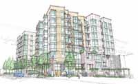
4 ELLIOTT BAY WEST SEATTLE DOWNTOWN PROJECT SITE PROJECT SITE TO FAUNTLEROY DOWNTOWN DUWAMISH WATERWAY Project Description Building height: - East Building: 84-6 plus 10-8 stair/elevator overrun and mechanical penthouses - West Building: 84-6 plus 10-8 stair/elevator overrun and mechanical penthouses Number of stories: - East Building: 7 stories - West Building: 7 stories Number of units: - East Building: 128 units - West Building: 70 units - Total: 198 units Amount of retail: East = 15,330 GSF, West = 10,355 GSF Total Project = 25,688 GSF Parking and service area access: - East and West building passenger vehicle parking access via 42nd Ave - East and West building service and loading areas via alley Number of parking stalls: - Total vehicle stall Required = Total vehicle stall Provided = Total Bike Stalls required/provided = 64 Solid Waste Storage: square feet required within each building, - East Building: 426 square feet provided - West Building: 486 square feet provided PROJECT DESCRIPTION

5 Process Timeline Project Kick-off Meeting Design Review Board: EDG # Design Review Board: EDG # Alley Vacation Petition SUMMER SOLSTICE TRANSIT/BIKE ROUTE PUGET SOUND VIEWS WINTER SOLSTICE WEST SEATTLE JUNCTION CALIFORNIA AVE SW SW ALASKA ST PROJECT SITE NEW CONSTRUCTION UNDERWAY 42ND AVE SW NEW CONSTRUCTION UNDERWAY DOWNTOWN VIEWS MT. RAIN IER VIEWS Alley Vacation Supplement MUP Submittal Design Commission Presentation Design Commission Presentation II Design Commission Presentation III/ Project Approval Design Review Board: Recommendation Meeting # 1 Design Review Board: Recommendation Meeting # 2 Design Review Board: Recommendation Meeting # 3/ Unanimous Approval Neighborhood Meeting # Neighborhood Meeting # RETAIL DISTRICT Neighborhood Meeting # Neighborhood Meeting # Neighborhood Meeting # Re-submit Corrected MUP Drawings Revise MUP Documents per Neighborhood Group s comments Neighborhood Group executes agreement w/ 2700 California Ave., LLC Present Alley Vacation to City Council SITE ANALYSIS / PROJECT TIMELINE

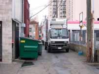
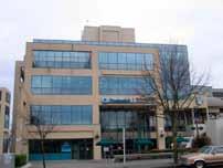
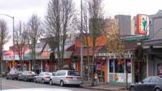
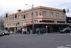
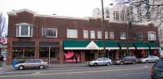
6 CONTEXT PHOTOS
7 2900 sf SW ALASKA STREET 20' Extent of Subterranean Vacation The applicant is requesting a subterranean alley vacation to allow for a continuous below grade parking garage for both buildings with a single garage entry from 42nd Avenue SW. The subterranean vacation does not provide additional development potential for the two building sites. The subterranean vacation is proposed to begin four feet below the existing alley surface to allow existing and future utilities to continue to extend below grade through the alley. Final depth will be based on coordination with SDOT. is approximately 2,900 sf. Alley surface and supporting structure depth 21 CALIFORNIA AVENUE SW 145' 42ND AVENUE SW Garage Level Plan Subterranean Alley Vacation EXTENT OF SUBTERRANEAN VACATION
8 SW ALASKA STREET Public Benefit Zone 1 - Enchancement to pedestrian environment CALIFORNIA AVENUE SW Public Benefit Zone II - Pedestrian through block connections ALLEY ALLEY 42ND AVENUE SW PUBLIC BENEFIT ZONES
9 ZONE I Additional Public Sidewalk Area West East Total Added Area at Street S.F S.F S.F. Retail Entry Area S.F S.F S.F. Residential Entry Area S.F. 120 S.F S.F. Total Area 3, S.F. ZONE II Additional Public Sidewalk Area West East Total Added Area at Alley 165 S.F S.F S.F. Mid-Block Pedestrian Walkway 1889 S.F S.F S.F. Residential Entry 0 S.F. 400 S.F. 400 S.F. Total Area S.F. Street Furnishings Public Benefit Total 4 Benches 13 Bollards 4 Bike Racks 12 Trash/Recycle Bins 10 Decorative Street Lights 10 Total Street Furnishings 46 Covered Area Public Benefit West East Total Overhead Coverage (17 clear min) S.F S.F S.F. Canopies at Sidewalk 979 S.F S.F S.F. Total Covered Area S.F. Street Furnishings Public Benefit Total 4 Benches 5 Bollards 21 Bike Racks 4 Trash/Recycle Bins 7 Tables 22 Decorative Street Lights 7 Total Street Furnishings 66 Covered Area Public Benefit West East Total Overhead Coverage (17 clear min) 72 S.F S.F S.F. Additional Canopies 383 S.F S.F S.F. Total Covered Area S.F. Art Program Total West Building (21 art pieces) 46 S.F. Art Program Total East Building (8 art pieces) 24 S.F. West Building (6 art pieces) 5 S.F. Total Public Art 70 S.F. East Building 0 S.F. Total Public Art 5 S.F. Public Retail Parking Benefit TOTAL Retail Parking Required 11 Stalls Added Public Retail Parking 62 Stalls TOTAL PUBLIC RETAIL PARKING 73 Stalls PUBLIC BENEFIT SUMMARY
10 Retail ' ' ' ' Residential VACATED ALLEY 2900 S.F. Amenity ' FF B.O.H ' FF ' FF Vertical Transportation Alley/Parking ' ' EXISTING ALLEY ' ' ' SITE PLAN / FIRST FLOOR PLAN (FOR REFERENCE) COPYRIGHT 2011 WEBER THOMPSON
11 Residential Amenity B.O.H. Vertical Transportation Alley/Parking UPPER LEVEL SETBACK LEVEL P-1 Upper Level Setbacks LEVEL 3-6 TYPICAL UPPER LEVEL SETBACK LEVEL 2 LEVEL FLOOR PLANS (FOR REFERENCE) COPYRIGHT 2011 WEBER THOMPSON


12 Residential amenity space entry Feature landscape element centered on mid-block pedsetrian walkway Alley looking at mid-block walkway Plaza space available for public use Landscape planting Pedestrian walkway paving Steel frames with special lighting to mark precinct Masonry framed entry to maintain rythym of retail bays and mark entry to mid-block pedestrian walkaway EAST MID-BLOCK PEDESTRIAN WALKWAY (FOR REFERENCE)

")
13 Reduced landscape planting between ramps and walkway Plaza at retail floor level Plaza at sidewalk elevation Harbor Properties plaza and landscaping Increased planter size at live/work units Harbor properties trellis Harbor properties ramp landings extend into landscaping EAST MID-BLOCK PEDESTRIAN WALKWAY (FOR REFERENCE)
 SOUTH ELEVATION (THROUGH")
 NORTH")

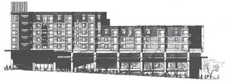
14 WEST ELEVATION (CALIFORNIA AVE. SW) SOUTH ELEVATION (THROUGH BLOCK CONNECTION) EAST ELEVATION (ALLEY) NORTH ELEVATION (SW ALASKA STREET) WEST BUILDING ELEVATIONS (FOR REFERENCE)

 EAST")
 NORTH ELEVATION")

15 WEST ELEVATION (ALLEY) SOUTH ELEVATION (THROUGH BLOCK CONNECTION) EAST ELEVATION (42ND AVE. SW) NORTH ELEVATION (SW ALASKA STREET) EAST BUILDING ELEVATIONS (FOR REFERENCE)
 03.08.")
16 LANDSCAPE PLAN (FOR REFERENCE)
17 (PAGE LEFT INENTIONALLY BLANK)


18 ZONE I Additional Public Sidewalk Area West East Total Added Area at Street S.F S.F S.F. ADDED BENEFIT SUB-TOTAL 1201 S.F. B SW ALASKA STREET C D Retail Entry Area S.F S.F S.F. Residential Entry Area S.F. 120 S.F S.F S.F. 496 S.F S.F. ENTRY AREA SUB-TOTAL S.F. Existing Sidewalks 3250 S.F S.F S.F. 605 S.F S.F. Dedicated Alley 5200 S.F. ZONE II Existing Public Right of Way Sub Total 13,950 S.F. OVERALL TOTAL 17, S.F. 20% Increase in Public Area over existing condition Additional Public Sidewalk Area West East Total Added Area at Alley 165 S.F S.F S.F. Mid-Block Pedestrian Walkway 1889 S.F S.F S.F. ADDED BENEFIT SUB-TOTAL S.F. Residential Entry Area 0 S.F. 400 S.F. 400 S.F. ENTRY AREA SUB TOTAL 400 S.F. Existing Sidewalks 3250 S.F S.F S.F. Dedicated Alley Total Area 5200 S.F S.F. OVERALL TOTAL 19, S.F. 28% Increase in Public Area over existing condition S.F. 200 S.F. CALIFORNIA AVENUE SW 1,889 S.F. A S.F S.F. ALLEY ALLEY 400 S.F S.F. E 42ND AVENUE SW S.F S.F. F 120 S.F ,825 S.F West mid-block pedestrian walkway Mid-block pedestrian walkway at 42nd Avenue ADDITIONAL PUBLIC SIDEWALK AREA
19 A. CALIFORNIA AVE. SW B. SW ALASKA STREET C. SW ALASKA ST. D. SW ALASKA STREET B. 42ND AVENUE SW F. 42ND AVENUE SW SIDEWALK DIMENSIONS

 4 Bollards")


20 SW ALASKA STREET CALIFORNIA AVENUE SW ALLEY 42ND AVENUE SW ZONE I QUANTITY CALCULATION 4' Benches TOTAL 13 ZONE II QUANTITY CALCULATION 4' Benches TOTAL 5 Bollards (Illuminated) 4 Bollards (Illuminated) 21 Bike Racks 12 Bike Racks 4 Trash/Recycle Bins 10 Trash/Recycle Bins 7 Decorative Street Lights TOTAL FURNISHINGS 7 46 Tables Decorative Street Lights TOTAL FURNISHINGS STREET FURNISHING DIAGRAM
 833.25 S.")

 383 S.F. 132.5 S.F. 515.5 S.F. Total Covered Area 1381.")
21 443 S.F. SW ALASKA STREET 769 S.F. 153 S.F. CALIFORNIA AVENUE SW 171 S.F. ALLEY 485 S.F. 42ND AVENUE SW 212 S.F. ZONE I Covered Area Public Benefit West East Total Overhead Coverage (17 clear min) S.F S.F S.F. Canopies at Sidewalk 979 S.F S.F S.F. Total Covered Area S.F. ZONE II Covered Area Public Benefit West East Total Overhead Coverage (17 clear min) 72 S.F S.F S.F. Additional Canopies (10 clear min) 383 S.F S.F S.F. Total Covered Area S.F. 377 S.F. 321 S.F. OVERHEAD COVERAGE DIAGRAM
22 SW ALASKA STREET ZONE I EAST BUILDING 1 Sculpture 3 S.F. 3 Sculpture 3 S.F Sculpture 3 S.F. 5 Sculpture 3 S.F. 6 Sculpture 3 S.F. 7 Sculpture 3 S.F. 8 Sculpture 3 S.F. TOTAL (8 Pieces) 24 S.F. WEST BUILDING CALIFORNIA AVENUE SW WEST EAST 42ND AVENUE SW 7 Glass Art 1 S.F. 7 8 Glass Art 1 S.F Glass Art 1 S.F. 10 Glass Art 1 S.F. 11 Glass Art 1 S.F. 12 Sculpture 4 S.F. 13 Sculpture 4 S.F. 14 Sculpture 4 S.F. 15 Sculpture 4 S.F. 16 Sculpture 4 S.F. 17 Sculpture 4 S.F. 18 Sculpture 4 S.F. 19 Sculpture 4 S.F. 20 Sculpture 4 S.F. 21 Sculpture 4 S.F. TOTAL (21 Pieces) 46 S.F. As the design process proceeds, 4700 California Ave., LLC will collaborate with the West Seattle Neighborhood Group to Develop and Public Art Program for the Building. The current design has incorporated 11 locations for small glass art installations and eighteen locations for larger sculptural panel installations (three to four square feet each). It is envisioned that the sculptural panels, designed by local artist, will in some way portray historic elements of the West Seattle neighborhood. ZONE II WEST BUILDING 1 Glass Art 1 S.F. 3 Glass Art 1 S.F. 4 Glass Art 1 S.F. 5 Glass Art 1 S.F. 6 Glass Art 1 S.F. TOTAL (6 Pieces) 5 S.F. WEST SEATTLE JUNCTION ART PROGRAM

23 In September of 2008 DPD/SDOT received a petition from a consortium of neighborhood groups and local merchants expressing concern that the alley between 42nd Avenue SW and California would be closed for the duration of construction. The petition was as follows: The above petition had several hundred signatures attached. In response to the Merchant s concerns, 4700 California Ave., LLC developed a strategy to keep the alley open during construction by providing a detour to 42nd Street during the below grade portion of the construction (See page 22) California Ave., LLC met with each of the Merchants who s store border the alley. Unanimously, every Merchant confirmed that the attached plan fully resolved the concerns voiced in the petition and withdrew their objections. RESPONSE TO PETITION
24 SW ALASKA STREET SW ALASKA STREET EXCAVATION Both sites including the alley vacation will be excavated and constructed up to the existing alley grade to the extent indicated. Alley to re-open to alley traffic on top of constructed structure. Fence at top of slope cut site. Slope cut site this area. Existing curb cut to be used for temporary alley access to 42nd Avenue SW. EXCAVATION Alley to re-open to alley traffic on top of constructed structure. CALIFORNIA AVENUE SW ACCESS 42ND AVENUE SW Existing 4700 California Ave., LLC property parking lot paving to be used for temporary alley access to 42nd Avenue SW. CALIFORNIA AVENUE SW ACCESS 42ND AVENUE SW SW EDMUNDS STREET SW EDMUNDS STREET RESPONSE TO PETITION
25 After the project was reviewed and unanimously approved by the Southwest Design Review Board, representatives from the West Seattle neighborhood contacted the City of Seattle and 4700 California Ave., LLC to request that 4700 California Ave., LLC enter into a facilitated, collaborative process to resolve a series of issues they felt had not been address during the Design Review process California Ave., LLC agreed to the request and participated in a series of meetings with the group covering a wide variety of issues. The process was facilitated by Gary Johnson, DPD. The following are the members of the neighborhood group: Susan Melrose Erica Karlovits Rene Commons Abdy Farid Heather Leaman Michael Godfried Rhonda Laumann West Seattle Junction Association Resident Resident Resident West Seattle Board of Directors Resident Resident After meeting with the group on five occasions and providing solutions to the groups concerns, the group agreed that significant progress had been made and executed the following agreement. All changes were approved the project s planner, Michael Dorcy and the Master Use Permit Documents were revised and re-submitted. NEIGHBORHOOD MEETING
26 Letter of Agreement Re: DPD projects # and # Charles Conner and 4700 California Ave LLC ( Applicant ) is proposing to construct two buildings on the south side of SW Alaska Street between California Avenue SW and 42nd Avenue SW. The west building is filed under DPD project # The east building is filed under project # The buildings will lie on either side of an alley. The proposal includes a request for a partial subterranean vacation of the alley to allow subsurface parking garages in each building to connect, resulting in a single access point for both garages on 42nd SW. This project required a request for a partial subterranean alley vacation request, which necessitated a review of the project by the Design Commission. The project was subject to the City s Design Review process and was reviewed by the Southwest Design Review Board. The DRB approved the project subject to the proponent addressing six outstanding issues to the satisfaction of DPD s land use planner for the project, Michael Dorcy. Several community members disputed the thoroughness and fairness of the DRB consideration of this significant project. As a way to explore potential changes to the project proposal that would address community concerns, both parties agreed to enter into a facilitated discussion process with representatives of some members, but not all, in the West Seattle Junction area. There are additional community members who had similar concerns, who were not included in this process, at the request of the facilitator. The City of Seattle Mayor s office selected Gary Johnson from the City of Seattle Department of Planning and Development to serve as the facilitator California Ave LLC was represented by venture partners Charlie Conner, President Conner Homes and Gary Young, Sr. Vice President, Polygon Northwest. Community members who attended the meetings and had input in the process were the following: Susan Melrose- West Seattle Junction Association; Heather Leaman - West Seattle Junction Association Board of Directors; Michael Godfried, Erica Karlovits, Rene Commons, Abdy Farid, and Rhonda Laumann- area residents. Project architect,jim Westcott from Weber Thompson participated throughout the process. 9. Applicant will contribute $5,000 towards development of Junction Plaza Park upon construction permit issuance. In signing this agreement, Applicant agrees to implement each element contained in the completed MUP and referenced drawings. Applicant also agrees that, if all or part of the project is sold, the commitments agreed to herein shall become conditions of sale and the requirements transferto the new owner. The agreements must transfer as conditions of sale to any and all future owners. The only community members bound by this agreement are those members whose names and signatures appear below. The below listed signatories agree that they will not appeal the DPD Director s Decision, so long as all conditions and this agreement are incorporated as requirements in the Director s Decision, as expressed in the Master Use Permit (MUP) decision. The signatories below will not oppose the project s partial subterranean alley vacation petition, contingent upon implementation of the construction plan, which leaves the alley operational throughout every phase of construction, when the alley vacation is considered by the City Council. This agreement will become part of the DPD MUP decision and incorporated into the MUP submission as a permanent document on record for projects no and , and subject to approval by the Seattle City Council, the Alley Vacation Conditions. If any changes are made to the MUP, such changes may invalidate this agreement. The community members listed below shall be advised of any changes to the MUP made by any party. notification is sufficient notification. The current MUP application reflects the changes agreed to by the parties. In addition the Applicant commits to the following: 1. To re-engage the community and solicit neighborhood participation in the design of cornices, sills, canopies, soldier courses, art, lighting and other details at the construction document phase. 2. Include an art panel program with historical representations in the north ground plane facade of both buildings. 3. Incorporate dark bronzed window framing at retail level. 4. Endeavor to reduce the planting strip on California 5 to 4 increasing sidewalk width to 8 6, subject to SDOT approval. 5. Install special pavement detail providing texture and way finding elements throughout the midblock passage. 6. Carry brick elements from West building to the north fagade offhe Eastbuilding. Preferably a light gray color rather than the red brick color of the West building. 7. Work with Harbor Properties to explore opportunities to integrate east building plaza with the mural project plaza including signage, pavers and other design elements. Install a way finding sign at plaza entrance that denotes the connection to California Avenue. Complete Plaza design details as part of construction documents. 8. The set of streetscape amenities including benches and pedestrian lighting proposed for the West building will be carried to the East Building. Landscaping on SW Alaska Street will be designed to integrate with the Junction Plaza Park across the street. NEIGHBORHOOD MEETING
West Seattle Junction City Council Transportation Committee Presentation Seattle, Washington April 26, 2011
 West Seattle Junction City Council Transportation Committee Presentation Seattle, Washington April 26, 2011 Contents Project Description... 2 Site Analysis / Project Timeline... 3 Context Photos... 4 Extent
UDC Street Cross Sections
 UDC Street Cross Sections Local Street - Downtown Local Street Mountable Curb Local Street Vertical Curb Alley Major Arterial Minor Arterial Residential Lane Residential Collector Residential Collector
WHITE STREET/ ENGLISH PLAZA STREETSCAPE IMPROVEMENT PROJECT
 WHITE STREET/ ENGLISH PLAZA STREETSCAPE IMPROVEMENT PROJECT 1 Project Goals 1 Improved Safety: Lighting, Multi-Modal Circulation, Emergency Access, Tripping Hazards; Stormwater 4 Environmental Performance:
PUBLIC REALM MASTER PLAN
 WESTSHORE BUSINESS DISTRICT PUBLIC REALM MASTER PLAN MASTER PLAN COMMITTEE MEETING MARCH 20, 2013 WESTSHORE BUSINESS DISTRCT PUBLIC REALM MASTER PLAN MACRO-SCALE CONCEPT: A PUBLIC REALM FRAMEWORK DEFINED
Streetscape: Core Shopping District
 Streetscape: Core Shopping District DRAFT DRAFT DRAFT May 00 Core Shopping District: Phase Blue Island s Core Shopping District is located along Western Avenue, between Grove and Union Streets. Streetscape
1.3 Pedestrian Environments
 SECTION 1: COMMERCIAL DEVELOPMENT 1.3 Pedestrian Environments Design Principle The quality of the pedestrian environment often defines the overall success of a commercial project. Attention to the development
City of Seattle Edward B. Murray, Mayor
 City of Seattle Edward B. Murray, Mayor Department of Transportation Scott Kubly, Director Eastlake Community Council 117 E Louisa St. #1 Seattle, WA 98102-3278 January 28, 2016 RE: Roosevelt to Downtown
RECOMMENDED MOTION: I MOVE TO PASS SECOND READING AND ADOPT ORDINANCE 556, TO REMOVE NE 173RD STREET FROM THE DESIGNATED PEDESTRIAN-ORIENTED STREETS.
 CITY OF WOODINVILLE, WA REPORT TO THE CITY COUNCIL 17301 133rd Avenue NE, Woodinville, WA 98072 wvvw.ci.woodinville.wa.us To: Honorable City Council Date: 02/05/2013 From: Richard A. Leahy, City Manager
S T A T I O N A R E A P L A N
 The Circulation and Access Plan describes vehicle, pedestrian, and transit improvements recommended within the Concept Plan. In order to create and sustain a vibrant business district that provides pedestrian-friendly
Guthriesville Village Manual of Written & Graphic Design Guidelines
 Exhibit B Revisions: May 23, June 21, July 20, September 20, & October 9, 2012 Updated: December 13, 2012; June 27, 2013; February 7, 2014 Outline of Contents: 1. Purpose and Applicability 2. Overall Form
Bicycle and Pedestrian Advisory Committee (BPAC) November 21, 2013
 November 21, 2013") Bicycle and Pedestrian Advisory Committee (BPAC) November 21, 2013 OVERALL LAND USE CONCEPT Overall Broadway Valdez District: 95.5 acres (35.1 acres right-of ways + 60.4 acres developable land) Plan Subareas:
Bicycle and Pedestrian Advisory Committee (BPAC) November 21, 2013 OVERALL LAND USE CONCEPT Overall Broadway Valdez District: 95.5 acres (35.1 acres right-of ways + 60.4 acres developable land) Plan Subareas:
Option W: N. Washington Street Project
 Option W: N. Washington Street Project Location: one block of North Washington Street, between West Broad Street and Park Avenue Description: upgrades to existing lighting new brick sidewalk to replace
FOCUS AREA 1 - Alberta Avenue Pocket Park 3 (121 Ave and 92 St)
") FOCUS AREA 1 - Alberta Avenue Pocket Park 3 (121 Ave and 92 St) New benches Plant evergreen trees Widen existing sidewalk from 1.5m to 1.8m Marked crosswalk 1.8m wide sidewalk Add pedestrian oriented lights
FOCUS AREA 1 - Alberta Avenue Pocket Park 3 (121 Ave and 92 St) New benches Plant evergreen trees Widen existing sidewalk from 1.5m to 1.8m Marked crosswalk 1.8m wide sidewalk Add pedestrian oriented lights
Derby Street. Project Updates. Salem, Massachusetts
 Derby Street Project Updates Salem, Massachusetts September 13, 2017 Project Limits Derby Street Project Objectives 1. Improve complete streets elements on Derby Street 2. Improve sidewalks on finger streets
Construction Staging Area Vaughan Road
 REPORT FOR ACTION Construction Staging Area - 109 Vaughan Road Date: May 25, 2017 To: Toronto and East York Community Council From: Acting Director, Transportation Services, Toronto and East York District
Arapahoe Square Zoning + Design Standards & Guidelines Task Force Meeting 9 January 27, 2016
 Arapahoe Square Zoning + Design Standards & Guidelines Task Force Meeting 9 January 27, 2016 Agenda 3:00 Opening/Welcome 3:15 Touch Base on Schedule and Milestones Moving Forward 3:20 Review the Overall
Sidewalk Cafe City of St. Petersburg City Code Chapter 16, Land Development Regulations
 Section 16.50.370 Sidewalk Café Sections: 16.50.370.1 Generally 16.50.370.2 Declarations 16.50.370.3 Definitions 16.50.370.4 Permit Required 16.50.370.5 Application, Permit and Fee 16.50.370.6 Liability
Comments on KXLY DRB Submittal from Southgate Neighborhood Council
 Final revision January 21, 2017 Introduction - Narrative and Summary (Page 3) Paragraph 3 states that Future-phase buildings are not part of this application. We understand that the final submittal clarifies
PEDESTRIAN CIRCULATION & STREETSCAPE DESIGN
 CHAPTER 4 Chapter 4 Pedestrian Circulation & Trails PEDESTRIAN CIRCULATION & STREETSCAPE DESIGN In recent years, the City has constructed new sidewalks and enhanced existing ones in the downtown with brick
5 CIRCULATION AND STREET DESIGN
 5 CIRCULATION AND STREET DESIGN This chapter describes circulation and streetscape improvements proposed for the Northwest Chico Specific Plan Area. It includes detailed design specifications for existing
ACTION TRANSMITTAL No
 Transportation Advisory Board of the Metropolitan Council of the Twin Cities DATE: August 25, 2016 TO: FROM: ACTION TRANSMITTAL No. 2016-47 Technical Advisory Committee TAC Funding and Programming Committee
Fulton Market Streetscape
 Fulton Market Streetscape Ogden Avenue to Halsted Street Public Meeting Recommended Improvements December 10th, 2014 Meeting Purpose and Goals Present Existing Conditions Community Input and Charrette
Incentive Zoning. Zoning Ordinance Advisory Committee June 21, Pam Thompson, Senior Planner, Sustainable Development and Construction
 Incentive Zoning Zoning Ordinance Advisory Committee June 21, 2018 Pam Thompson, Senior Planner, Sustainable Development and Construction Presentation Overview Stakeholder questions Updated charts Design
RIVERSIDE, Newton MA BH NORMANDY RIVERSIDE LLC. Riverside Station. A green, transit-oriented community
 Riverside Station A green, transit-oriented community October 6, 2011 TONIGHT S AGENDA: 1. Project Update (5 min.) 2. Master Plan Update (10 min.) 3.Traffic Plan Update (10 min.) Questions & Answers MASTER
To: Planning Commission Date: September 19, 2012 From: By: Subject:
 To: Planning Commission Date: September 19, 2012 From: By: Subject: City of Woodinville, WA Report to the planning commission 17301 133 rd Avenue NE, Woodinville, WA 98072 www.ci.woodinville.wa.us Richard
TRAVEL PLAN: CENTRAL EUROPEAN UNIVERSITY CAMPUS REDEVELOPMENT PROJECT TRAVEL PLAN. Central European University Campus Redevelopment Project.
 TRAVEL PLAN Central European University Campus Redevelopment Project Page 1 Table of Contents Introduction... 3 Background... 7 Building Users... 7 Transportation in Community Consultation... 7 Summary
Ann Arbor Downtown Street Plan
 1 Ann Arbor Downtown Street Plan Public Workshop #1 We know that. 2 Public right-of-way (streets, sidewalks, and alleys) make up 30% of the total District area of downtown. Streets need to provide mobility
Victoria Park Master Plan
 Victoria Park Master Plan Phase I Presented By: ARCHITECTURAL ALLIANCE & HUGHES HUGHES INC. History of Victoria Park Phase I Purpose Inventory of Existing Conditions Identification of Options by Type (for
3.1 TRAFFIC CALMING PROCESS SUMMARY
 SECTION 3 3.0 TRAFFIC CALMING 3.1 TRAFFIC CALMING PROCESS SUMMARY Traffic calming is a means in which to reduce speeds and minimize vehicular traffic on local neighborhood streets. Citizen involvement
Obey Creek PEDESTRIAN CIRCULATION EAST WEST PARTNERS PEDESTRIAN CIRCULATION CREEK SIDE LANE SLIP STREET SCOTT MURRAY MAIN STREETS EAST/WEST
 THE VILLAGE AT PEDESTRIAN CIRCULATION MAIN STREETS NORTH/SOUTH MAIN STREETS EAST/WEST SLIP STREET CREEK SIDE LANE PEDESTRIAN CIRCULATION DESCRIPTION: Circulation through the downtown of is organized by
MARTIN LUTHER KING JR. WAY
 OCTOBER 2011 40 Vision and Goals The Martin Luther King, Jr. Way Illustrative Master Plan that follows has been developed through a process of community involvement. It expresses a long term vision for
NEIGHBOURHOOD TRAFFIC COMMITTEE POLICY AND PROCEDURE
 The City of Vaughan 2141 Major Mackenzie Drive Vaughan, Ontario Canada L6A 1T1 Tel (905) 832-2281 NEIGHBOURHOOD TRAFFIC COMMITTEE POLICY AND PROCEDURE REVISED JUNE 2010 APPLICABILITY The Neighbourhood
Americans with Disabilities Act Transition Plan for Public Right-of-Way Improvements
 Americans with Disabilities Act Transition Plan for Public Right-of-Way Improvements Prepared by: Public Works Department Engineering Division October 2015 Table of Contents Section I Introduction.. 3
Ocean Park Boulevard Green Street Project Alternatives & Trade Offs
 Planning Commission March 4, 2009 Ocean Park Boulevard Green Street Project Alternatives & Trade Offs Purpose of Tonight s Meeting Review concept plans and options Provide input on alternatives and trade-offs
ADA on Construction. Guidance for Section C Plan Preparers
 ADA on Construction Guidance for Section C Plan Preparers Some impacts cannot be avoided and those impacts apply to residents, businesses, motorists, and pedestrians alike. However, good planning can minimize
Why invest in the 1 Street S.W. Corridor?
 Why invest in the 1 Street S.W. Corridor? This project is an investment in the Beltline Community and Calgary s economy. It is anticipated that The City s investment along this corridor will help with
Accommodating Pedestrians in the Work Zone
 Accommodating Pedestrians in the Work Zone Guidance for Section C Plan Preparers Some impacts cannot be avoided and those impacts apply to residents, businesses, motorists, and pedestrians alike. However,
CONNECTIVITY PLAN. Adopted December 5, 2017 City of Virginia Beach
 CONNECTIVITY PLAN Adopted December 5, 2017 City of Virginia Beach CONTENTS 1.0 Background & Purpose... 2 2.0 Existing Inventory & Analysis... 3 ViBe District Existing Walking Conditions... 4 3.0 ViBe District
Agenda. Overview PRINCE GEORGE S PLAZA METRO AREA PEDESTRIAN PLAN
 PRINCE GEORGE S PLAZA METRO AREA PEDESTRIAN PLAN May 28, 2008 Agenda Welcome and introductions Project overview and issue identification Planning context and strengths Design challenges and initial recommendations
7/23/2017 VIA . Michael Hanebutt City of Sacramento Community Development Department 300 Richards Boulevard, 3 rd Floor Sacramento, CA 95811
 7/23/2017 VIA EMAIL Michael Hanebutt City of Sacramento Community Development Department 300 Richards Boulevard, 3 rd Floor Sacramento, CA 95811 RE: 65 th Street Apartments (DR17-220) Dear Mr. Hanebutt:
Chapter BICYCLE PARKING REQUIREMENTS
 The following are proposed text changes to Chapter 17.117. Additions to the chapter are underlined; deletions are in strikeout. Chapter 17.117 BICYCLE PARKING REQUIREMENTS Sections: Article I. - General
Broad Street Bicycle Boulevard Design Guidelines
 Broad Street Bicycle Boulevard Design Guidelines Building from the strategies introduced in the 2013 Bicycle Transportation Plan and community input received thus far, City Transportation Staff have identified
CURBSIDE ACTIVITY DESIGN
 5 CURBSIDE ACTIVITY DESIGN This chapter provides design guidance for separated bike lanes adjacent to curbside activities including parking, loading and bus stops. Typical configurations are presented
Environment and Public Works Committee Presentation
 Mixed Use Centers Complete Streets Guidelines Project Environment and Public Works Committee Presentation December 10, 2008 Project Objectives: Conduct an inter-departmental and agency process to study
Ocean Park Boulevard Green Street Project Community Workshop
 Ocean Park Boulevard Green Street Project Community Workshop 2.2.10 Project Objectives Community Priority: reclaim OPB for public open space. Build upon LUCE principles; neighborhood enhancement, connectivity,
ROUTE 81 CORRIDOR STUDY DESIGN CONCEPTS
 RT 81 Corridor Study CLINTON ROUTE 81 CORRIDOR STUDY DESIGN CONCEPTS View north on High Street, with potential improvements to the streetscape Draft Recommendations November 8 th, 2018 TOWN OF CLINTON
3.1 TRAFFIC CALMING PROCESS SUMMARY
 SECTION 3 3.0 TRAFFIC CALMING 3.1 TRAFFIC CALMING PROCESS SUMMARY Traffic calming is a means in which to reduce speeds and minimize vehicular traffic on local neighborhood streets. Citizen involvement
City of Darlington Beautification Report
 City of Darlington Beautification Report Approved by the City of Darlington Beautification Board February 2016 The New Downtown Darlington has seen many changes during the past decade with the rehabilitation
STATE OF VERMONT ENVIRONMENTAL COURT } } } } } Decision and Order
 STATE OF VERMONT ENVIRONMENTAL COURT In re: Appeal of Ted S. Gladstone and Kathleen Hoisington Docket No. 190-10-99 Vtec Decision and Order Appellants appealed from a decision of the Planning Commission
Figure 4-10: Pedestrian Improvements Types of Potential Station Area Improvements - Place-Making Improvements
 INCORPORATE FEATURE PAVIN IN CROSSWALK AND INTERSECTION FIELDS Identifies high-priority pedestrian areas and create a station identity through colorful and interesting patterns ADD CURB EXTENSIONS Extending
Aurora Urban Street Standards For Transit Oriented Developments and Urban Centers
 Aurora Urban Street Standards For Transit Oriented Developments and Urban Centers I. Purpose These standards will be applied to create a safe, comfortable, pleasant and pedestrian-friendly multi-modal
TRANSPORTATION STANDARDS
 INTRODUCTION LOCAL STREETS ON-STREET PARKING SIDEWALKS STREET LIGHTING STREET FURNISHINGS TRAFFIC CALMING STREET TREES MEDIAN PLANTING BOULEVARD LOCATIONS VILLAGE CENTER STREET LOCATIONS RESIDENTIAL STREET
WHEREAS delivery trucks also pass through the Narrows, into the northern parking lot, to loading docks in the back of the building.
 CEDAR-ISLES-DEAN NEIGHBORHOOD ASSOCIATION ( CIDNA ) RESOLUTION OPPOSING A DRUG STORE DRIVE THRU, AND COMMENDING DORAN COMPANIES FOR PROPOSING MITIGATING AMENITIES INCLUDING NEW LANDSCAPING AND A DEDICATED
complete streets design and construction standards public primer City of Edmonton
 complete streets design and construction standards public primer City of Edmonton introduction Complete Streets are streets for everyone: people who walk, wheel, bike, take transit, or drive. They are
This chapter describes the proposed circulation system and transportation alternatives associated with
 5.0 Circulation 5.1 OVERVIEW This chapter describes the proposed circulation system and transportation alternatives associated with West Landing, and summarize the information contained in the Existing
UPTOWN REGIONAL BIKE CORRIDORS PROJECT SAN DIEGO ASSOCIATION OF GOVERNMENTS
 UPTOWN REGIONAL BIKE CORRIDORS PROJECT SAN DIEGO ASSOCIATION OF GOVERNMENTS SUMMARY REPORT: COMMUNITY UPDATE MEETING February 6, 2014 6 8:30 p.m. Roosevelt Middle School Library 3366 Park Blvd, San Diego
Community Meeting February 27, 2007 Dorchester Avenue Transportation & Streetscape Improvements Action Plan February 27, 2007
 Community Meeting Tonight s Agenda 6:00 Introductions South Boston/Dot Ave Improvement Study Background 6:15 Consultant Introductions Review of Scope and Schedule Review of Proposed Corridor Wide Guidelines
BROOKLAND Multi-Modal Transportation & Streetscape Study* NE Washington, DC
 BROOKLAND Multi-Modal Transportation & Streetscape Study* NE Washington, DC The study s goal is to create a multi-modal transportation and streetscape design plan to increase transportation efficiency,
2014/2015 BIKE ROUTE PLAN 83 AVENUE PROTECTED BIKE LANE
 About the Project The City of Edmonton is planning a major bike route on the southside of Edmonton. The Strathcona Bike Route will connect the communities of Strathcona, Garneau and the University area,
Three Springs Design Guidelines Fencing and Wall Standards
 Three Springs Design Guidelines Fencing and Wall Standards Original Adopted: June 12, 2006 Minor Amendment: December 2012 Minor Amendment: March 23, 2017 TABLE OF CONTENTS: FENCING AND WALLS 1.0 INTRODUCTION
PRINCE GEORGE S PLAZA METRO AREA PEDESTRIAN PLAN
 PRINCE GEORGE S PLAZA METRO AREA PEDESTRIAN PLAN May 28, 2008 Agenda Welcome and introductions Project overview and issue identification Planning context and strengths Design challenges and initial recommendations
Feasibility Study. Expo-Downtown Bicycle Connector
 Feasibility Study Expo-Downtown Bicycle Connector May 2017 Table of Contents Introduction... 2 Project Goals... 2 Study Scope... 2 Community Engagement... 3 Project Description... 6 Considerations... 6
Exhibit 1 PLANNING COMMISSION AGENDA ITEM
 Exhibit 1 PLANNING COMMISSION AGENDA ITEM Project Name: Grand Junction Circulation Plan Grand Junction Complete Streets Policy Applicant: City of Grand Junction Representative: David Thornton Address:
Appendix B - Street Sections
 Appendix B - Street Sections 6TH STREET CORRIDOR PLAN STREET SECTIONS The street sections in Appendix B include recommended improvements to streets for North Glenwood. They include existing conditions
STREETSCAPE / URBAN DESIGN ELEMENTS
 CITY OF CHEYENNE STREETSCAPE / URBAN DESIGN ELEMENTS DEFINITIONS TABLE OF CONTENTS Introduction How To Use This Guide...1 Design Elements Sidewalks...2 Street Corners and Curb Extension...4 Trees and Landscape
APPENDIX A: Complete Streets Checklist DRAFT NOVEMBER 2016
 APPENDIX A: Complete Streets Checklist DRAFT NOVEMBER 2016 Complete Streets Checklist MetroPlan Orlando s Complete Streets Checklist is an internal planning tool for staff to further implementation of
Omaha s Complete Streets Policy
 Omaha s Complete Streets Policy (Adopted August 2015) VISION To create great places and enhance our quality of life, the City of Omaha will provide safe, accessible streets for all users. Complete Streets
STREETSCAPE CONCEPTS
 STREETSCAPE S CARGO WAY CARGO WAY CYCLE TRACK Streetscape Concepts JENNINGS ST Illustrative Plan EVANS AVE PG&E BAY TRAIL HERON S HEAD PARK The recommended improvements build off the planned improvements
PROJECT SUMMARY ALBERTA STREETSCAPE PROJECT
 ALBERTA STREETSCAPE PROJECT Revitalizing a Street Rebuilding a Community Realizing a Dream PROJECT SUMMARY December 2001 Project Background In 1998 and 1999, the Alberta Street community was engaged in
A CHANGING CITY. of Edmonton, it is essential that it reflects the long-term vision of the City.
 A CHANGING CITY By the year 2040, Edmonton will be home to more than 1 million people. To accommodate growth and support a healthy and compact city, we need a new approach to development/redevelopment
Design of Stanley Park S-Curve
 ADMINISTRATIVE REPORT Date: May 4, 2001 TO: FROM: Author/Local: F. Klotzbach/7118 RTS NO. 01644 CC File No. Standing Committee on Transportation and Traffic General Manager of Engineering Services, in
2200 FIFTH STREET CONTINUED PRELIMINARY DESIGN REVIEW
 D E S I G N R E V I E W C O M M I T T E E S t a f f R e p o r t CONTINUED PRELIMINARY DESIGN REVIEW For Committee Discussion/ Majority Recommendation MARCH 16, 2017 Design Review #DRCP2016-0006 of the
Geary Bus Rapid Transit Project
 Geary Bus Rapid Transit Project Urban Forestry Council Planning and Funding Committee Meeting September 13, 2016 SAN FRANCISCO COUNTY TRANSPORTATION AUTHORITY SAN FRANCISCO MUNICIPAL TRANSPORTATON AGENCY
Observations and Ideas: Toomer s Corner Streetscape Improvements
 Observations and Ideas: Toomer s Corner Streetscape Improvements AUBURN DOWNTOWN MASTER PLAN planning downtown s future August 26, 2013 Observations: Vertical Clutter at Corners 6 3 7 5 9 2 8 4 1 Excess
MAG Town of Cave Creek Bike Study Task 6 Executive Summary and Regional Significance Report
 Page 1 MAG Town of Cave Creek Bike Study Task 6 Executive Summary and Regional Significance Report August 1, 2012 MAG Project #481 Page 2 Task 6 Executive Summary and Regional Significance Report Introduction
Update on the Downtown Street Event Closure Recommendations. Briefing to City Council March 26, 2008
 Update on the Downtown Street Event Closure Recommendations Briefing to City Council March 26, 2008 Background Information June 5, 2008 Austin City Council unanimously adopted Ordinance No. 20090605-045
 COMPLETE STREETS CHECKLIST City of Philadelphia The City of Philadelphia's Complete Streets policies are designed ensure that city streets are safe, comfortable and convenient for people of all ages and
PIONEER SQUARE ACTIVE STREETS
 Walking Audit April 0, 0 DRAFT Observations & Recommendations Early one Tuesday morning in February, more than 0 people, representing residents, business, property owners and city departments, gathered
AGENDA REPORT. Issue: Discussion of potential improvements on Barnwell Road at Niblick Drive
 AGENDA REPORT To: From: By: Honorable Mayor and City Council Members Warren Hutmacher, City Manager Tom Black, Public Works Director Date: March 23, 2016 Agenda: March 28, 2016 WORK SESSION AGENDA: Barnwell
ALBERTA AVENUE WHAT WE HEARD REPORT BUILDING GREAT NEIGHBOURHOODS
 ALBERTA AVENUE WHAT WE HEARD REPORT BUILDING GREAT NEIGHBOURHOODS FEBRUARY 2019 EXECUTIVE SUMMARY Starting in 2019, Alberta Avenue will see the replacement and enhancement of its aging collector and local
WORKSHOP 2 SUMMARY OVERVIEW GENERAL COMMENTS. Walking and Biking. Greening & Stormwater. Transportation & Parking. Lighting, Art and Identity
 WORKSHOP 2 SUMMARY OVERVIEW On May 9, 2016, 55 people came to the second public meeting for the Lower Haight Public Realm Plan. Roughly 34 of attendees were neighborhood residents. The open house was a
Capital Improvement Project Application: Bike Racks, Bus Stop Shelters, Sidewalks in Kings Canyon/Ventura Corridor Page 1 of 10
 Bike Racks, Bus Stop Shelters, Sidewalks in Kings Canyon/Ventura Corridor Page 1 of 10 Project Summary 1. Project Title: Bike Racks, Bus Stop Shelters, Sidewalks in Kings Canyon/Ventura Corridor 2. Project
ATTACHMENT 4 - TDM Checklist. TDM Checklist Overview
 ATTACHMENT 4 - TDM Checklist TDM Checklist Overview The proposed checklist rates developments on the degree to which they are TDM and transit supportive. Points are assigned based on the level of transit
Comments EXECUTIVE SUMMARY
 Comments 1. Under any Alternatives, MCDOT should provide better at-grade pedestrian crossing of Georgia Avenue and Forest Glen Road, including improved crosswalks with wider medians and adequate signal
Town of Mooresville, North Carolina Neighborhood Traffic Calming and Control Device Policy
 Town of Mooresville, North Carolina Neighborhood Traffic Calming and Control Device Policy Adopted January 6, 2014 Town of Mooresville Development Services Department TOWN OF MOORESVILLE NEIGHBORHOOD TRAFFIC
Citizens Handbook for Requesting Traffic Calming Devices
 Citizens Handbook for Requesting Traffic Calming Devices January 19, 2015 Table of Contents 1. PURPOSE... - 1-2. DEFINITIONS... - 2-3. GENERAL INFORMATION... - 3-3.1. ELIGIBILITY REQUIREMENTS... - 3-3.2.
Item No. 14 Town of Atherton
 Item No. 14 Town of Atherton CITY COUNCIL STAFF REPORT CONSENT AGENDA TO: THROUGH: FROM: HONORABLE MAYOR AND CITY COUNCIL GEORGE RODERICKS, CITY MANAGER MICHAEL KASHIWAGI, COMMUNITY SERVICES DIRECTOR MARTY
Orinda Bicycle, Trails and Walkways Master Plan
 Orinda Bicycle, Trails and Walkways Master Plan Public Meeting October 15, 2008 Presented by: Ian Moore, Alta Lauren Ledbetter, Alta Bruce Wolff, Alta Introductions City of Orinda Monica Pacheco, Assistant
PEDESTRIAN ACTION PLAN
 ATTACHMENT 2 CITY OF SANTA MONICA PEDESTRIAN ACTION PLAN CITY OF SANTA MONICA PEDESTRIAN ACTION PLAN This page intentionally left blank EXECUTIVE SUMMARY CHAPTER 1 EXECUTIVE SUMMARY Setting the Stage
CITY OF KASSON TRANSPORTATION ALTERNATIVES KASSON SAFE ROUTES TO SCHOOL
 ve ha 8t G B A Mantorville Ave N 240th Ave 16th St NE 11th Ave NE K-M HIGH SCHOOL SUNRISE TRAIL TO MANTORVILLE MNTH 57 SUNSET TRAIL TO MANTORVILLE NE PARK 16TH ST NE TRAIL K-M ELEMENTARY SCHOOL K-M MIDDLE
Brooklyn Boulevard (County Road 152) Reconstruction Project Phase I. OPEN HOUSE June 20, 2017
 Reconstruction Project Phase I. OPEN HOUSE June 20, 2017") Brooklyn Boulevard (County Road 152) Reconstruction Project Phase I OPEN HOUSE June 20, 2017 Brooklyn Boulevard (County Road 152) Phase I Project Partners Project Lead Other Project Partners include Brooklyn
Brooklyn Boulevard (County Road 152) Reconstruction Project Phase I OPEN HOUSE June 20, 2017 Brooklyn Boulevard (County Road 152) Phase I Project Partners Project Lead Other Project Partners include Brooklyn
TRAFFIC CALMING TOOLBOX. For the residents of the City of Decatur, Georgia
 TRAFFIC CALMING TOOLBOX For the residents of the City of Decatur, Georgia 2 City of Decatur Traffic Calming Toolbox Public Works Department 2635 Talley Street Decatur, GA 30030 404.377.5571 3 Welcome to
studio 646 ARCHITECTURE, LLC
 ZONING DATA AND EXPLANATION FOR THE SPECIAL PERMIT APPLICATION: The present zoning for this project is R-2. The proposal includes eight residential townhome units accommodated within two buildings, with
County of Greenville South Carolina. Traffic Calming Program Neighborhood Traffic Education Program and Speed Hump Program
 County of Greenville South Carolina Traffic Calming Program Neighborhood Traffic Education Program and Speed Hump Program (rev) August 2008 I. PURPOSE The potential negative impacts from vehicular traffic
5. Automobile Circulation, Wayfinding and Signage
 5. Automobile Circulation, Wayfinding and Signage Policy: The City Center should have a balanced, safe, and interconnected circulation system that provides expanded travel opportunities for transit, pedestrian,
Bikeway action plan. Bicycle Friendly Community Workshop March 5, 2007 Rochester, MN
 Bikeway action plan Summary The was held on March 5, 2007 at the Rochester Mayo Civic Center. The workshop was hosted by Rochester-Olmsted County Planning Department in collaboration with the League of
NEIGHBORHOOD TRAFFIC CALMING PROGRAM. Policy and Procedure. Roswell Department of Transportation (770)
") NEIGHBORHOOD TRAFFIC CALMING PROGRAM Policy and Procedure Roswell Department of Transportation (770) 594 6420 Approved by M&CC on December 19, 2011 Table of Contents 1. Application and Intent 2. Program
NEIGHBORHOOD TRAFFIC CALMING PROGRAM Policy and Procedure Roswell Department of Transportation (770) 594 6420 Approved by M&CC on December 19, 2011 Table of Contents 1. Application and Intent 2. Program
Prepared By: Town of Waxhaw Traffic Calming Policy
 Policy For Resolutions for Town Meetings Prepared By: Town Manager Michael McLaurin Director Greg Mahar CPD Waxhaw N.C. Community Planning &Development Administrative Department Department: Date Approved
DRAFT. Lecompton. Table of Contents. Background
 Lecompton Table of Contents Existing Infrastructure 98 Funding 100 Policy and Program Recommendations 102 Infrastructure Recommendations 104 Conclusion 109 Douglas County Lecompton Background Located at
Martha Coello, Fairfax County DOT Jeffrey Hermann, Fairfax County DOT Abi Lerner, VDOT. May 19, 2014
 Traforming Tyso From An Auto Oriented Activity Center Into a Multi-Modal Center Martha Coello, Fairfax County DOT Jeffrey Hermann, Fairfax County DOT Abi Lerner, VDOT May 19, 2014 2 11 miles to Dulles