American Association of State Highway and Transportation Officials
|
|
|
- Samuel Hood
- 5 years ago
- Views:
Transcription
 Route U.S. 98 Alternate Route the Establishment of a U.S. (I) Route * the Establishment of a U.")
 Route ** the Recognition of a By-Pass Route on U.")


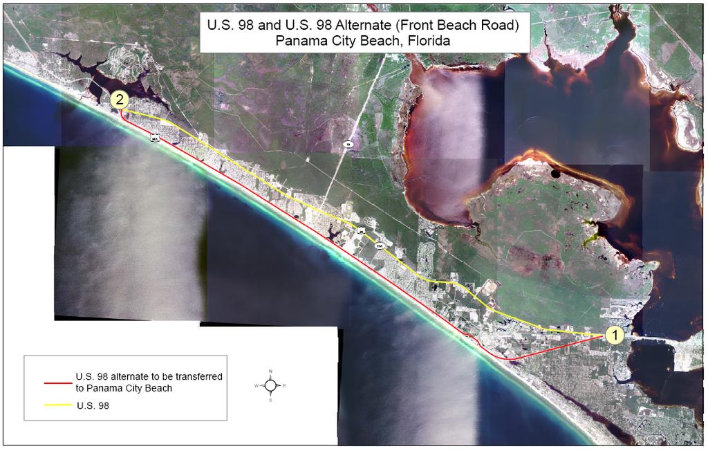
1 American Association of State Highway and Transportation Officials An Application from the State Highway or Transportation Department of FLORIDA for the Elimination of a U.S. (I) Route U.S. 98 Alternate Route the Establishment of a U.S. (I) Route * the Establishment of a U.S. Bike Route the Relocation of a U.S. (I) Route * the Relocation of a U.S. Bike Route the Extension of a U.S. (I) Route the Establishment of a U.S. Alternate Route the Establishment of a Temporary U.S. Route ** the Recognition of a Business Route on U.S. (I) Route ** the Recognition of a By-Pass Route on U.S. Route Between West apex with U.S. 98 and East apex with U.S. 98 The following states or states are involved: Florida 1 Date submitted: * Attach map on page 3. Obtain Signatures, page 4. Other sections not applicable. ** A local vicinity map needed on page 3. On page 6 a short statement to the effect that September 25, there are no deficiencies on proposed routing, if true, will suffice. If there are deficiencies, they should be indicated in accordance with page 5 instructions. SUBMIT SIX COPIES
2 The purpose of the United States (U.S.) Numbered Highway System is to facilitate travel on the main interstate highways, over the shortest routes and the best available roads. A route should form continuity of available facilities through two or more states that accommodate the most important and heaviest motor traffic flow in the area. The routes comprising the National System of Interstate and Defense Highways will be marked with its own distinctive route marker shield and will have a numbering system that is separate and apart from the U.S. Numbered Highway System. For the convenience of the motorist, there must be continuity and a uniform pattern of marking and numbering these Interstate routes without regard to state lines. The U.S. Numbered System was established in 1926 and the Interstate Numbered System was established in Both have reached the period of review, revision, and consolidation. They now need perfecting rather than expansion. Therefore, any proposed alteration in the established systems should be extremely meritorious and thoroughly, though concisely, explained in order that the Special Committee on U.S. Route Numbering and the Standing Committee on Highways of the Association may give prompt and proper consideration to each and every request made by a member department. Explanation and Reasons for the Request: (Keep concise and pertinent.) This action will remove an unneeded route from the U.S. numbered system and facilitate the jurisdiction transfer of this facility from the State Highway System to the city street system of Panama City Beach, Florida. The City of Panama City Beach, Florida, has authorized the Mayor (by City Commission Resolution #06-69) to enter into an agreement with the Florida Department of Transportation for the transfer of jurisdiction and maintenance of a portion of U.S. 98 Alternate through Panama City Beach to the city street system from the State Highway System. Public support for this was given at the City Council Meeting held on September 14, This facility will be transferred to the city street system conditioned on approval of this U.S. 98 Alternate Route elimination. Date facility available to traffic Currently in operation Does the petition propose a new routing over a portion of an existing U.S. Route? NO If so, where? Does the petition propose a new routing over a portion of an existing Interstate Route? NO If so, where? 2
3 3
4
5 Instructions for Preparation of Page 6 Column 1: Control Points and Mileage. Top of column is one terminus of road. Indicate control points by identical number as shown on map on page 3. Show mileage between control points in miles and tenths. Column 2: Pavement Type. Code High type, heavy duty H Intermediate type I Low type, dustless L (show in red) Not paved N (show in red) Column 3: Pavement Condition Code Excellent E Good G Fair F (show in red) Poor P (show in red) NOTE: In columns 2 and 3, where pavements types and conditions change, the location of the change shall be indicated by a short horizontal line at the proper place opposite the mileage log and the proper code letter (shown above) shall be entered in the respective column between the locations so indicated. Column 4: Columns 5 & 6 Columns 7 & 8 Column 9: Column 10: Column 11 Traffic. Indicate average daily traffic volumes in this column. Points of changes in these data to be indicated by short horizontal lines opposite the appropriate mileage point on the mileage log. Any existing main line rail crossing that is not separated shall be indicated at the appropriate mileage point by RXR - black if signalized - red if not protected by signals. Pavement Width and Shoulder Width. These columns to be completed by comparing standards of highway involved with applicable AASHTO standards. Entries that fall to the right of the tolerance lines (dashed) should be shaded in red. If there are no deficiencies indicate by use of the word NONE. Major Structures. Show in these columns those structures that do not meet AASHTO standards. Show by horizontal line sufficiently long to indicate percentage of deficiency. Portion on right of tolerance line shall be shown in red. Indicate length of structure in feet immediately under the line. Any sub-standard highway underpass structure shall be shown opposite the appropriate mileage point by the designation LP with the vertical clearance in feet following and shown in red. If there are no deficiencies indicate by the use of the word NONE. Vertical Sight Distance. Items to be shown in this column as a horizontal line, the length of which will indicate the deficiency as determined in accordance with comparisons with comparable AASHTO standards. Portions of the line past the tolerance line shall be shown in red. Horizontal Curvature. Curves in excess of AASHTO applicable standards to be shown in this column by a short horizontal line with degree of curve shown immediately above the line. To be shown in red. Percent Grades. Show by horizontal lines opposite proper mileage point on mileage log. Show percent of grade above the line and length of grade in feet immediately below. To be shown in red. 5
6 Mileage Control Points and Mileage Pavement Type Pavement Condition Traffic ADT Pavement Width Percent Percent Percent Percent Comparison to Applicable AASHTO Design Standards Shoulder Width Major Structures Roadway Width H - Loading Vertical Sight Distance Percent Show When In Excess of Standard Horizontal Curvature Degree Percent Grade Length Route begins St. Andrews Bay Leaves US Route ends Phillips Inlet Rejoins US 98 Attach additional sheet here if necessary 6
7 UNITED STATES HIGHWAY NUMBER 98 Point Accumulated To Point Mileage in State Type Intersection Mileage State Remarks Florida Regular West Palm Beach 0 0 Route begins, Jct. U.S. 1 West Palm Beach 1 1 Crosses I-95 Jct. W. West Palm 8 9 Joins U.S. 441 Beach Okeechobee Leaves U.S. 441 Jct. S. Sebring Joins U.S. 27 Sebring Avon Park Jct. S.W. Frostproof Jct. W. Frostproof Leaves U.S. 27 Fort Meade Joins U.S. 17 Bartow Leaves U.S. 17 Lakeland Crosses U.S. 92 Jct. N. Lakeland Crosses I-4 S. of Dade City Joins U.S. 301 S. Dade City U.S. 98 Bus. begins and leaves Business S. Dade City 0 0 Route begins, leaves U.S. 98 N. Dade City 1 1 Route ends, rejoins U.S. 98 Regular N. Dade City U.S. 98 Bus. rejoins and ends N. of Dade City Leaves U.S. 301 Jct. E. Brooksville Crosses I-75 Brooksville Crosses U.S. 41 Jct. S. Homosassa Joins U.S. 19 Springs Homosassa Springs Crystal River Chiefland Joins U.S. 27 Alt.; U.S. 129 joins and ends Old Town Cross City Jct. S. Perry U.S. 221 joins and ends Perry Leaves U.S. 19; crosses U.S. 27; U.S. 27 Alt. Begins Medart Joins U.S. 319 Jct. S. Medart Leaves U.S. 319 Jct. E. Carrabelle Joins U.S. 319 Apalachicola U.S. 319 ends Port St. Joe N. of Highland View Begin new alignment S. of St. Joe Beach End new alignment Parker U.S. 98 Bus. begins and leaves Business Parker 0 0 Route begins, leaves U.S. 98 Panama City 6 6 U.S. 231 joins and ends Panama City 3 9 Route ends, rejoins U.S. 98 Regular Panama City Crosses U.S. 231 Panama City U.S. 98 Bus. rejoins and Ends 142 Corrections in RED
8 Point Accumulated To Point Mileage in State Type Intersection Mileage State Remarks St. Andrews Bay U.S. 98 Alt. begins and leaves Alternate St. Andrews Bay 0 0 Route begins, leaves U.S. 98 Phillips Inlet Route ends, rejoins U.S. 98 Regular Phillips Inlet U.S. 98 Alt. rejoins and ends Jct. E. Santa Rosa U.S. 331 joins and ends Beach Pensacola U.S. 98 Bus. begins and leaves; joins U.S. 90 Business Pensacola 0 0 Route begins, leaves U.S. 98 Pensacola 1 1 I-110 joins and ends Pensacola 1 2 Route ends, rejoins U.S. 98 Regular Pensacola U.S. 29 joins and ends, crosses I-110 Pensacola Leaves U.S. 90 Pensacola U.S. 98 Bus. rejoins and ends State Line Corrections in RED
American Association of State Highway and Transportation Officials An Application from the State Highway or Transportation Department of
 American Association of State Highway and Transportation Officials An Application from the State Highway or Transportation Department of for: Elimination of a U.S. (Interstate) Route Establishment of a
Updated August 1, 2016
 Updated August 1, 2016 American Association of State Highway and Transportation Officials An Application from the State Highway or Transportation Department of North Carolina for: Elimination of a U.S.
American Association of State Highway and Transportation Officials An Application from the State Highway or Transportation Department of
 American Association of State Highway and Transportation Officials An Application from the State Highway or Transportation Department of for: Elimination of a U.S. (Interstate) Route Establishment of a
Updated June 12, 2017
 Updated June 12, 2017 American Association of State Highway and Transportation Officials An Application from the State Highway or Transportation Department of for: Elimination of a U.S. (Interstate) Route
Updated August 1, 2016
 5 Updated August 1, 2016 American Association of State Highway and Transportation Officials An Application from the State Highway or Transportation Department of Alabama for: Elimination of a U.S. (Interstate)
AASHTO Use Only Establishment of a U.S. (Interstate) Route IH 69 Action taken by SCOH: Extension of a U.S. (Interstate)Route
 Route IH 69 Action taken by SCOH: Extension of a U.S. (Interstate)Route") American Association of State Highway and Transportation Officials An Application from the State Highway or Transportation Department of Texas for: Elimination of a U.S. (Interstate) Route AASHTO Use Only
American Association of State Highway and Transportation Officials An Application from the State Highway or Transportation Department of Texas for: Elimination of a U.S. (Interstate) Route AASHTO Use Only
Application to AASHTO to recognize six suggested relocations of U.S. Bicycle Route 1 in the Northern Virginia District.
 September 7 th, 2007 Application to AASHTO to recognize six suggested relocations of U.S. Bicycle Route 1 in the Northern Virginia District. Acting District Administrator Mr. Morteza Salehi has endorsed
 U.S. 63 & U.S. 63 BUS US Route Number State Type Intersection Point to Point Accumulated Remarks 63 Arkansas Regular Mammoth Springs 0 0 Missouri State Line 63 Arkansas Regular Hardy 16 16 Crosses U.S.
American Association of State Highway and Transportation Officials. Virginia. for
 American Association of State Highway and Transportation Officials An Application from the State Highway or Transportation Department of Elimination of a U.S. (Interstate) Route Establishment of a U.S.
AASHTO is in receipt of the following member department interstate application.
 June 4, 2015 Mr. Greg adeau Deputy Administrator Federal ighway Administration 1200 ew Jersey Ave., S Washington, DC 20590 Dear Mr. adeau: AAST is in receipt of the following member department interstate
Geometric Design Tables
 Design Manual Chapter 5 - Roadway Design 5C - Geometric Design Criteria 5C-1 Geometric Design Tables A. General The following sections present two sets of design criteria tables - Preferred Roadway Elements
Act 47 Exception Application Process (Permitting Bicycle Travel on Freeways)
") Act 47 Exception Application Process (Permitting Bicycle Travel on Freeways) Attached is a revised application process to permit Pedalcycle travel on the shoulders of freeways within the Commonwealth.
Act 47 Exception Application Process (Permitting Bicycle Travel on Freeways) Attached is a revised application process to permit Pedalcycle travel on the shoulders of freeways within the Commonwealth.
City of Roseville Section 13 Design Standards. _Bikeways January 2016 SECTION 13 BIKEWAYS
 SECTION 13 BIKEWAYS 13-1 GENERAL The City of Roseville bikeway standards are designed to insure that transportation and recreational bikeways are constructed in a manner that would provide a safe and comfortable
3-13 UFC - GENERAL PROVISIONS AND GEOMETRIC DESIGN FOR ROADS, STREETS, WALKS, AND OPEN
 maintenance, and erosion. Stability is required to maintain the integrity of the pavement structure, and a slope stability analysis should be conducted for cuts and fills greater than 15 feet. For lower
Designing with the Railroad
 Designing with the Railroad 23 CFR 646.214 (b)(2) requires that crossings be evaluated when they are within limits or near terminus of Federally Funded project. Some rough numbers for planning: Active
Long Island Rail Road Expansion Project Floral Park to Hicksville
 Long Island Rail Road Expansion Project Floral Park to Hicksville Final Environmental Impact Statement Appendix 1-D Complete Streets Policy Checklist April 2017 0902ML PIN: Project Location: 18A-4 Floral
October 2004 REVISIONS (2) SUPERELEVATION DEVELOPMENT 11.3(2)
 SUPERELEVATION DEVELOPMENT 11.3(2)") October 2004 REVISIONS (2) Chapter 11 HORIZONTAL ALIGNMENT SUPERELEVATION DEVELOPMENT 11.3(2) Chapter 12 VERTICAL ALIGNMENT VERTICAL CURVES PASSING SIGHT DISTANCE 12.5(2) VERTICAL CURVES STOPPING SIGHT
October 2004 REVISIONS (2) Chapter 11 HORIZONTAL ALIGNMENT SUPERELEVATION DEVELOPMENT 11.3(2) Chapter 12 VERTICAL ALIGNMENT VERTICAL CURVES PASSING SIGHT DISTANCE 12.5(2) VERTICAL CURVES STOPPING SIGHT
PERFORMANCE ACTIVITY 405 LIMB MANAGEMENT
 PERFORMANCE ACTIVITY 405 LIMB MANAGEMENT 405 LIMB MANAGEMENT ACTIVITY DESCRIPTION Cut and/or remove and/or grind tree limbs from the right-of-way. TRAFFIC CONTROL Utilize intermittent mobile operations
Off-road Trails. Guidance
 Off-road Trails Off-road trails are shared use paths located on an independent alignment that provide two-way travel for people walking, bicycling, and other non-motorized users. Trails specifically along
South Carolina Department of Transportation. Engineering Directive
 South Carolina Department of Transportation Engineering Directive Directive Number: ED-22 Effective: December 16, 2009 Subject: References: Purpose: This Directive Applies to: Considerations for Bicycle
Palm Beach MPO Complete Streets Policy
 Palm Beach MPO Complete Streets Policy Citizens Advisory Committee March 2, 2016 www.palmbeachmpo.org 2300 North Jog Road 4 th Floor West Palm Beach, FL 33411 561-684-4170 What are Complete Streets? Complete
SCHOOL CROSSING PROTECTION CRITERIA
 CITY OF MADISON TRAFFIC ENGINEERING SCHOOL CROSSING PROTECTION CRITERIA AUGUST 1990 Adopted as Policy on August 31, 1976, by Common Council by Amended Resolution #29,540 Amended on September 14, 1976,
Levels, and Road Uses
 Tahoe Unsurfaced Roads Workshop UC Cooperative Extension / SAF / TRPA / LWQCB / CGS / USFS Road Standards, Maintenance Levels, and Road Uses Gordon R. Keller, PE, GE Geotechnical Engineer grkeller@fs.fed.us
CHAPTER 16 PEDESTRIAN FACILITIES DESIGN AND TECHNICAL CRITERIA TABLE OF CONTENTS
 CHAPTER 16 PEDESTRIAN FACILITIES DESIGN AND TECHNICAL CRITERIA TABLE OF CONTENTS Section Title Page 16.1 General... 16-1 16.1.1 AASHTO Reference... 16-1 16.1.2 ADA Requirements... 16-1 16.2 Sidewalks...
GEOMETRIC DESIGN STANDARDS FOR NEW RESIDENTIAL SUBDIVISION STREETS TABLE 1A CG-6 CURB AND GUTTER SECTION
 TABLE 1A CG-6 CURB AND GUTTER SECTION HORIZONTAL AND VERTICAL CONTROLS CURB AND GUTTER ROADWAYS MAXIMUM 3:1 CUT OR FILL SLOPE CURVE DATA MIN. SIGHT DISTANCE PROJECTED TRAFFIC VOLUME (ADT) MIN. DESIGN SPEED
Design Criteria. Design Criteria
 F Design Criteria Design Criteria Ministry of Transportation Ministère des Transports DESIGN CRITERIA Page: 1 of 13 WORK PROJECT NO. N/A GO Bloomington Station TYPE OF PROJECT LOCATION Bloomington Road
Sponsored by the Office of Traffic and Safety of the Iowa Department of Transportation NOVEMBER 2001 CTRE
 PAVED SHOULDERS ON PRIMARY HIGHWAYS IN IOWA: AN ANALYSIS OF SHOULDER SURFACING CRITERIA, COSTS, AND BENEFITS EXECUTIVE SUMMARY Sponsored by the Office of Traffic and Safety of the Iowa Department of Transportation
WYDOT DESIGN GUIDES. Guide for. NHS Arterial (Non-Interstate)
") WYDOT DESIGN GUIDES Guide for NHS Arterial (Non-Interstate) 2014 GUIDE FOR NATIONAL HIGHWAY SYSTEM (NHS) HIGHWAYS (NHS ARTERIALS, Non-Interstate) PRESERVATION REHABILITATION RECONSTRUCTION INTRODUCTION
WYDOT DESIGN GUIDES Guide for NHS Arterial (Non-Interstate) 2014 GUIDE FOR NATIONAL HIGHWAY SYSTEM (NHS) HIGHWAYS (NHS ARTERIALS, Non-Interstate) PRESERVATION REHABILITATION RECONSTRUCTION INTRODUCTION
TRAFFIC CONTROLS FOR BICYCLE FACILITIES
 Part 9. TRAFFIC CONTROLS FOR BICYCLE FACILITIES TABLE OF CONTENTS Chapter 9A. GENERAL Page Section 9A.1 Requirements for Bicyclist Traffic Control Devices............................. 9A-1 9A.2 Scope.................................................................
SCHOOL CROSSING PROTECTION CRITERIA
 CITY OF MADISON TRAFFIC ENGINEERING SCHOOL CROSSING PROTECTION CRITERIA January 2016 Adopted as Policy on August 31, 1976, by Common Council by Amended Resolution #29,540 Amended on September 14, 1976,
Montclair s Complete Streets Experience
 Presented by: Hon. Jerry Fried, Mayor Montclair Township About Montclair Six square miles Six commuter rail stations Four local bus routes (NJ Transit) Two private commuter bus routes Five business districts
Roadway Design Manual
 Roadway Design Manual Revised December 2013 2013 by Texas Department of Transportation (512) 302-2453 all rights reserved Manual Notice 2013-1 From: Manual: Mark A. Marek, P.E Roadway Design Manual Effective
American Railway Engineering and Maintenance of Way Association Letter Ballot. Draft
 American Railway Engineering and Maintenance of Way Association Letter Ballot 1. Committee and Subcommittee: Committee 5 Track Subcommittee 9 Road Crossings 2. Letter Ballot Number: 05-17-16 3. Assignment:
(This page left intentionally blank)
") (This page left intentionally blank) 2011 Edition- Revision 2 Page 813 CHAPTER 9A. GENERAL Section 9A.01 Requirements for Bicyclist Traffic Control Devices 01 General information and definitions concerning
(This page left intentionally blank) 2011 Edition- Revision 2 Page 813 CHAPTER 9A. GENERAL Section 9A.01 Requirements for Bicyclist Traffic Control Devices 01 General information and definitions concerning
Who is Toole Design Group?
 2018 AASHTO Bike Guide Status Update NCHRP 15 60 Amalia Leighton Cody, PE, AICP & Kenneth Loen, PE Washington APWA October 4, 2018 Who is Toole Design Group? TDG is a full service engineering, planning
WYDOT DESIGN GUIDES. Guide for. Non-NHS State Highways
 WYDOT DESIGN GUIDES Guide for Non-NHS State Highways 2014 GUIDE FOR Non-NATIONAL HIGHWAY SYSTEM (Non-NHS) STATE HIGHWAYS PRESERVATION REHABILITATION RECONSTRUCTION INTRODUCTION This Guide is directed to
2004 Traffic and Safety Notes. Cross Reference between the Old Note Number and the New Note Number
 Michigan Department of Transportation 2004 Traffic and Safety Notes Cross Reference between the Old Note Number and the New Note Number OLD NEW Number Number Title (Prior to 2004) 1.1.1 101-Series General
Progress Report on the Design and Planning of an Infrastructure Improvement Project for the Sunnyside TIF District (Phase II)
") Presentation to the CNRC Board of Directors Regular Meeting March 11, 2015 1 Agenda Preferred Alternate Refinement for University Avenue, 3rd Street, and Beverly Avenue Intersection Improvements validate
Presentation to the CNRC Board of Directors Regular Meeting March 11, 2015 1 Agenda Preferred Alternate Refinement for University Avenue, 3rd Street, and Beverly Avenue Intersection Improvements validate
Alberta Infrastructure HIGHWAY GEOMETRIC DESIGN GUIDE AUGUST 1999
 Alberta Infrastructure HIGHWAY GEOMETRIC DESIGN GUIDE AUGUST 1999,1'(; A ACCELERATION Data on acceleration from stop D-29 Effects of grade D-35 Intersections D-97, D-99 Lanes D-97, F-5, F-7, F-15, F-21,
A plan for improved motor vehicle access on Railroad Avenue in Provincetown
 A plan for improved motor vehicle access on Railroad Avenue in Provincetown February 2011 A plan for improved motor vehicle access on Railroad Avenue in Provincetown INTRODUCTION AND PROBLEM IDENTIFICATION
1609 E. FRANKLIN STREET HOTEL TRAFFIC IMPACT STUDY EXECUTIVE SUMMARY
 1609 E. FRANKLIN STREET HOTEL TRAFFIC IMPACT STUDY EXECUTIVE SUMMARY Prepared for: The Town of Chapel Hill Public Works Department Traffic Engineering Division Prepared by: HNTB North Carolina, PC 343
Developed by: The American Traffic Safety Services Association (ATSSA) 15 Riverside Parkway, Suite 100 Fredericksburg, VA
 15 Riverside Parkway, Suite 100 Fredericksburg, VA") Addendum Developed by: The American Traffic Safety Services Association (ATSSA) 15 Riverside Parkway, Suite 100 Fredericksburg, VA 22406-1022 800-272-8772 This material is based upon work supported by
Addendum Developed by: The American Traffic Safety Services Association (ATSSA) 15 Riverside Parkway, Suite 100 Fredericksburg, VA 22406-1022 800-272-8772 This material is based upon work supported by
The Engineering Approach to Traffic Safety
 The Engineering Approach to Traffic Safety D o nald S. B erry Director, Traffic and Transportation Division National Safety Council Chicago, Illinois As traffic volume continues to grow, it is essential
Malvern Borough Local Traffic Calming
 Malvern Borough Local Traffic Calming Purpose: To address speeding and high volume cut-through traffic on Malvern Borough owned residential streets. Traffic Calming Measures: Traffic Calming Measures (TCM)
FINAL REPORT OKLAHOMA RAILROAD GRADE CROSSING SAFETY TASK FORCE
 FINAL REPORT of OKLAHOMA RAILROAD GRADE CROSSING SAFETY TASK FORCE May 21,1998 BOB ANTHONY Commissioner OKLAHOMA DENISE A. BODE Commissioner Corporation Commission _O_K_LA_H_o_PM_'O_~_:_~:_y_5~_:_:_:_-:_:_O:_M_A
Traffic Accident Data Processing
 Traffic Accident Data Processing D o n a l d F. P e t t y Engineer of Traffic Research and Surveys Indiana State Highway Commission The following is a portion of the Highway Safety Program Standards developed
CHAPTER 6H. TYPICAL APPLICATIONS
 2006 Edition Page 6H-1 CHAPTER 6H. TYPICAL APPLICATIONS Section 6H.01 Typical Applications Support: Whenever the acronym TTC is used in this Chapter, it refers to temporary traffic control. Standard: The
CURBSIDE ACTIVITY DESIGN
 5 CURBSIDE ACTIVITY DESIGN This chapter provides design guidance for separated bike lanes adjacent to curbside activities including parking, loading and bus stops. Typical configurations are presented
5. RUNNINGWAY GUIDELINES
 5. RUNNINGWAY GUIDELINES These guidelines should be considered collectively when making runningway decisions. A runningway is the linear component of the transit system that forms the right-of-way reserved
Including Revision 1 dated May 2012 and Revision 2 dated May 2012
 Including Revision 1 dated May 2012 and Revision 2 dated May 2012 Page 634 2009 Edition Notes for Figure 6H-1 Typical pplication 1 Work eyond the Shoulder 1. If the work space is in the median of a divided
Complete Streets for Louisiana
 Complete Streets for Louisiana Louisiana Transportation Conference 2011 Ellen W. Soll, AICP Planner Burk-Kleinpeter, Inc esoll@bkiusa.com 504.486.5901 x143 What is a Complete Street? What are Complete
PERFORMANCE ACTIVITY 306 DRAINAGE PIPE WORK DESCRIPTION 4
 PERFORMANCE ACTIVITY 306 DRAINAGE PIPE WORK DESCRIPTION 1 WORK DESCRIPTION 2 WORK DESCRIPTION 3 WORK DESCRIPTION 4 Repair Install Remove Clean 306 DRAINAGE PIPE ACTIVITY DESCRIPTION Install, repair, clean,
Access Management in the Vicinity of Intersections
 Access Management in the Vicinity of Intersections FHWA-SA-10-002 Technical Summary Photo: Ralph Bentley (used with permission) 0 Access Management is: The design, implementation and management of entry
TRAFFIC SIGNAL WARRANT STUDY
 TRAFFIC SIGNAL WARRANT STUDY 5 th STREET & ENCHANTED PINES DRIVE JANUARY 2013 TRAFFIC OPERATIONS ENGINEERING SERVICES/PUBLIC WORKS DEPARTMENT TABLE OF CONTENTS INTERSECTION LOCATION MAP ii INTRODUCTION
Chapter V TRAFFIC CONTROLS. Tewodros N.
 Chapter V TRAFFIC CONTROLS www.tnigatu.wordpress.com tedynihe@gmail.com Lecture Overview Traffic markings Longitudinal markings Transverse markings Object markers and delineator Traffic signs Regulatory
Section 9A.07 Meaning of Standard, Guidance, Option, and Support
 2012 Edition Page 895 PART 9. TRAFFIC CONTROLS FOR BICYCLE FACILITIES CHAPTER 9A. GENERAL Section 9A.01 Requirements for Bicyclist Traffic Control Devices 01 General information and definitions concerning
DESIGN MEMORANDUM WITH DESIGN EXCEPTIONS SP SP
 DRAFT NOT FINAL (Note: document was not finalized due to an eastbound stopping site distance design issue that requires more detailed bridge and roadway design considerations. This discussion starts on
APPENDIX A: Complete Streets Checklist DRAFT NOVEMBER 2016
 APPENDIX A: Complete Streets Checklist DRAFT NOVEMBER 2016 Complete Streets Checklist MetroPlan Orlando s Complete Streets Checklist is an internal planning tool for staff to further implementation of
FOR HISTORICAL REFERENCE ONLY
 To: From: Subject: Electronic Distribution Recipients MINNESOTA DEPARTMENT OF TRANSPORTATION Engineering Services Division Technical Memorandum No. 12-14-B-03 December 18, 2012 Jon M. Chiglo, P.E. Division
Roadway Design Manual
 Roadway Design Manual Manual Notice Archive by Texas Department of Transportation (512) 302-2453 all rights reserved Manual Notice 2009-1 From: Manual: Mark A. Marek, P.E Roadway Design Manual Effective
INDEX. Geometric Design Guide for Canadian Roads INDEX
 Acceleration lane, see Lanes, Acceleration Access, 8.1 Access Management and Functional Classification 8.2 Access Management by Design Classification 8.3 Access Configuration 8.4 Building Set-Back Guidelines
Shared Use Path Design
 12B-2 Design Manual Chapter 12 - Sidewalks and Bicycle Facilities 12B - Bicycle Facilities Shared Use Path Design A. Accessible Shared Use Path Design 1. General: Applicable portions from the following
700 Multi-Modal Considerations
 700 Multi-Modal Considerations Table of Contents 701 Railroads... 7-1 701.1 Background... 7-1 701.2 Crossing At-Grade... 7-1 701.2.1 General... 7-1 701.2.2 Railroad Parallel to Highway... 7-1 701.3 Lateral
Off-Road Facilities Part 1: Shared Use Path Design
 Off-Road Facilities Part 1: Shared Use Path Design Presentation by: Eric Mongelli, P.E. Tom Huber October 9, 2012 FOLLOW THE CONVERSATION ON TWITTER Toole Design Group is live tweeting this webinar @tooledesign
Gordon Proctor Director Policy on Accommodating Bicycle and Pedestrian Travel on ODOT Owned or Maintained Facilities
 Approved: Policy: 20-004(P) Responsible Office: Planning Gordon Proctor Director Policy on Accommodating Bicycle and Pedestrian Travel on ODOT Owned or Maintained Facilities I. POLICY STATEMENT: This policy
Duwamish Way-finding and CTR Report
 V. North Tukwila When the North Tukwila Manufacturing and Industrial Center was designated in 1992 as part of the region s land use and transportation plan, the plan called for the area to set a light-rail
Attached for your reference please find project updates on ongoing VDOT construction projects in Southampton County.
 SOUTHAMPTON COUNTY BOARD OF SUPERVISORS Regular Session i July 25, 2016 6. HIGHWAY MATTERS A. PLAN PROJECT UPDATES Attached for your reference please find project updates on ongoing VDOT construction projects
Memorandum. Exhibit 60 SSDP To: Jenny Bailey, Senior Planner. From: Bill Schultheiss, P.E. (WA. P.E. #46108) Date: June 20, 2017
 Date: June 20, 2017") Memorandum To: Jenny Bailey, Senior Planner From: Bill Schultheiss, P.E. (WA. P.E. #46108) Date: June 20, 2017 Re: East Lake Sammamish Trail, Segment 2B Review King County has asked Toole Design Group
Memorandum To: Jenny Bailey, Senior Planner From: Bill Schultheiss, P.E. (WA. P.E. #46108) Date: June 20, 2017 Re: East Lake Sammamish Trail, Segment 2B Review King County has asked Toole Design Group
CHAPTER 6H. TYPICAL APPLICATIONS
 Section 6H.01 Typical Applications Support: CHAPTER 6H. TYPICAL APPLICATIONS Chapter 6G contains discussions of typical temporary traffic control activities. Chapter 6H presents typical applications for
APPENDIX G: INTERSECTION NEEDS AT OKEECHOBEE BOULEVARD
 APPENDIX G: INTERSECTION NEEDS AT OKEECHOBEE BOULEVARD INTERSECTION NEEDS AT SR 7 and OKEECHOBEE BOULEVARD SR 7 Extension Project Development and Environment (PD&E) Study From Okeechobee Boulevard (SR
CHAPTER 3 SIGNS, SIGNALS AND PAVEMENT MARKINGS. Responsible Driving (Red book) NOTES & STUDY GUIDE
 NOTES & STUDY GUIDE") CHAPTER 3 SIGNS, SIGNALS AND PAVEMENT MARKINGS Responsible Driving (Red book) NOTES & STUDY GUIDE Regulatory Signs Warning Signs International Signs Guide Signs Types of Road Signs Sub category (construction
CHAPTER 3 SIGNS, SIGNALS AND PAVEMENT MARKINGS Responsible Driving (Red book) NOTES & STUDY GUIDE Regulatory Signs Warning Signs International Signs Guide Signs Types of Road Signs Sub category (construction
Route 47 (North Main Street) Reconstruction
 Reconstruction") TOWN OF SUNDERLAND Route 47 (North Main Street) Reconstruction Presented by Lou Rabito, P.E. Presented to Town of Sunderland June 11, 2018 Project Overview MassDOT Project No. 607245 Resurfacing and Related
TOWN OF SUNDERLAND Route 47 (North Main Street) Reconstruction Presented by Lou Rabito, P.E. Presented to Town of Sunderland June 11, 2018 Project Overview MassDOT Project No. 607245 Resurfacing and Related
Overview. Illinois Bike Summit IDOT Complete Streets Policy Presentation. What is a Complete Street? And why build them? And why build them?
 Overview Illinois Bike Summit IDOT Complete Streets Policy Presentation Aren Kriks, P.E. District One Bicycle Coordinator and Bureau of Programming Project Engineer History of Complete Streets IDOT Policy
TABLE OF CONTENTS. General... A. New Construction/Reconstruction (4R)...B. Resurfacing, Restoration and Rehabilitation (3R)...C
...B. Resurfacing, Restoration and Rehabilitation (3R)...C") - LOCAL AGENCY PROJECTS TABLE OF CONTENTS Section General... A New Construction/Reconstruction (4R)...B Resurfacing, Restoration and Rehabilitation (3R)...C Preventive Maintenance (PM)... D Design Exception...E
- LOCAL AGENCY PROJECTS TABLE OF CONTENTS Section General... A New Construction/Reconstruction (4R)...B Resurfacing, Restoration and Rehabilitation (3R)...C Preventive Maintenance (PM)... D Design Exception...E
On Road Bikeways Part 1: Bicycle Lane Design
 On Road Bikeways Part 1: Bicycle Lane Design Presentation by: Nick Jackson Bill Schultheiss, P.E. September 04, 2012 FOLLOW THE CONVERSATION ON TWITTER Toole Design Group is live tweeting this webinar
Access Management Standards
 Access Management Standards Section 1: Application of Access Standards This chapter describes the Department's access management standards for access connections on the county roadway system. The standards
CE576: Highway Design and Traffic Safety
 CE576: Highway Design and Traffic Safety Predicting Crash Frequency for Two-Lane Rural Highway Segments Cross Sectional Elements Ahmed Abdel-Rahim, Ph.D., P.E. Civil Engineering Department University of
What Engineering Can Do for You! Low Cost Countermeasures for Transportation Safety
 What Engineering Can Do for You! Low Cost Countermeasures for Transportation Safety Adam Larsen Safety Engineer Federal Highway Administration 360-619-7751 Adam.Larsen@DOT.GOV Adam Larsen TTP Safety Engineer
Engineering Countermeasures for Transportation Safety. Adam Larsen Safety Engineer Federal Highway Administration
 Engineering Countermeasures for Transportation Safety Adam Larsen Safety Engineer Federal Highway Administration 360-619-7751 Adam.Larsen@DOT.GOV Countermeasure Selection Resources Manual for Selecting
TOWN OF PAYSON TRAFFIC CALMING MANUAL
 TOWN OF PAYSON TRAFFIC CALMING MANUAL APPROVED BY THE PAYSON TOWN COUNCIL SEPTEMBER 6, 2007 TOWN OF PAYSON TRAFFIC CALMING POLICY 1.0 Introduction Traffic Calming involves retrofitting physical devices
Road Safety Evaluation ation A process to investigate traffic safety on tribal, county, or city roadways Roadway may be selected for evaluation if the
 Road Safety Evaluation Shoalwater Bay Roads WSDOT Highways & Local Programs Road Safety Evaluation ation A process to investigate traffic safety on tribal, county, or city roadways Roadway may be selected
REGIONAL BICYCLE AND PEDESTRIAN DESIGN GUIDELINES
 REGIONAL BICYCLE AND PEDESTRIAN DESIGN GUIDELINES November 16, 2011 Deb Humphreys North Central Texas Council of Governments Bicycle and Pedestrian Advisory Committee Snapshot of the Guide 1. Introduction
Monroe County Department of Transportation Vertical Curve Safety Study
 Monroe County, New York PREPARED FOR: Monroe County Department of Transportation 50 West Main Street Suite 6100 Rochester, NY 14614 PREPARED BY: 255 East Avenue Rochester, New York 14604 project # 434934
Design of Stanley Park S-Curve
 ADMINISTRATIVE REPORT Date: May 4, 2001 TO: FROM: Author/Local: F. Klotzbach/7118 RTS NO. 01644 CC File No. Standing Committee on Transportation and Traffic General Manager of Engineering Services, in
JONESBORO HIGHWAY 63 HIGHWAY 18 CONNECTOR STUDY
 JONESBORO HIGHWAY 63 HIGHWAY 18 CONNECTOR STUDY Craighead County May 2007 JONESBORO HIGHWAY 63 HIGHWAY 18 CONNECTOR STUDY Craighead County May 2007 Prepared by Planning and Research Division Arkansas State
American Association of State Highway and Transportation Officials
 American Assciatin f State Highway and Transprtatin Officials Please save and send as a wrd file. Yu can attach a map in PDF r JPG with the applicatin t usrutes@aasht.rg (M.Vitale) An Applicatin frm the
City of Margate, Florida. Neighborhood Traffic Management Manual
 City of Margate, Florida Neighborhood Traffic Management Manual Table of Contents Page No. I. INTRODUCTION... 1 II. TRAFFIC CALMING REQUEST AND PROCESSING PROCEDURES... 2 1. COMPLETE AND SUBMIT PROJECT
IH 20 RANGER HILL PUBLIC MEETING
 IH 20 RANGER HILL PUBLIC MEETING AUGUST 25, 2015 IH 20, Eastland County, TX CSJ 0007-06-084 IH 20 from 3.5 mi. East of LP 254 to SH 16 (Ranger Hill) August 25, 2015 Agenda Introductions Purpose of the
guide signs or groups of signs. General provisions are given in Sections 2A.07, 2A.08, and 2A.10. Standard:
 Page 186 2011 Edition CHAPTER 2D. GUIDE SIGNS CONVENTIONAL ROADS Section 2D.01 Scope of Conventional Road Guide Sign Standards 01 The provisions of this Chapter shall apply to any road or street other
Non-Motorized Overpass at SR 5/US1
 Non-Motorized Overpass at SR 5/US1 And SR 97/SW th Street (Bird Road) Executive Summary March 9, 17 Prepared By: MARLIN Engineering Inc 17 NW th Avenue, Ste. 1 Plantation, FL 33313 P: 35.77.7575 www.marlinengineering.com
2012 by the American Association of State Highway and Transportation Officials. All rights reserved. Duplication is a violation of applicable law.
 Table of Contents Chapter 1: Introduction... 1-1 1.1 Design Imperative... 1-1 1.2 Purpose... 1-1 1.3 Scope... 1-2 1.4 Definitions... 1-2 Chapter 2: Bicycle Planning... 2-1 2.1 Background... 2-1 2.2 Why
To position power poles a safe distance from the road to minimise the likelihood of being accidentally hit by vehicles.
 Policy Statement Subject Placement of Rigid Distribution Poles Along Roads With Speed Limits Exceeding 70KM/H Approved by Robert Rogerson Signature & Date Distribution Standards and Policy Manager Authorised
MEMORANDUM. Discussion of the planned crosswalk improvement on Mount Vernon Road near Stratham Drive
 MEMORANDUM To: From: Mayor and City Council Michael Smith, Public Works Director Date: August 24, 2015 Subject: Discussion of the Mount Vernon Road Crosswalk Improvement ITEM DESCRIPTION Discussion of
CHAPTER 1 STANDARD PRACTICES
 CHAPTER 1 STANDARD PRACTICES OBJECTIVES 1) Functions and Limitations 2) Standardization of Application 3) Materials 4) Colors 5) Widths and Patterns of Longitudinal Pavement Marking Lines 6) General Principles
NEIGHBORHOOD TRAFFIC CALMING PROGRAM. Policy and Procedure. Roswell Department of Transportation (770)
") NEIGHBORHOOD TRAFFIC CALMING PROGRAM Policy and Procedure Roswell Department of Transportation (770) 594 6420 Approved by M&CC on December 19, 2011 Table of Contents 1. Application and Intent 2. Program
NEIGHBORHOOD TRAFFIC CALMING PROGRAM Policy and Procedure Roswell Department of Transportation (770) 594 6420 Approved by M&CC on December 19, 2011 Table of Contents 1. Application and Intent 2. Program
Traffic Control Inspection Checklist Segment:
 Traffic Control Inspection Checklist Segment: Simon Contractors Simon Contractors Originator: Description Reviewed by: Initials Date Distribution: Traffic Quality Manager, Site Assistant Traffic Manager
INDOT Complete Streets Guideline & Policy
 INDOT Complete Streets Guideline & Policy INTRODUCTION The Complete Streets guidelines build upon multiple efforts and promote a multimodal transportation system that is integrated and sustains land use
County of Spartanburg South Carolina
 County of Spartanburg South Carolina Traffic Calming Program June 2012 (Revised/Program on Hold) PURPOSE The potential negative impacts from vehicular traffic on residential roads have been a longstanding
Shenango Valley MPO. State Transportation Commission 2015 Twelve Year Program Development
 State Transportation Commission 2015 Twelve Year Program Development Regional results of the survey and public feedback from August thru November 2013 Shenango Valley MPO Version 01-2014 Mobility Concerns
PUBLIC,UTILITIES COMMSSION OF THE
 GENERAL ORDER NO. 88-8 (Supersedes General Order No. 88-A) PUBLIC,UTILITIES COMMSSION OF THE.. STATE OF CALIFORNIA RULES FOR ALTERING PUBLIC HIGHWAY-RAIL CROSSINGS ADOPTED January 8,2004. EFFECTIVE February