NASNI. With all the ships in port, the population of NASNI is nearly 35,000 active duty military, military reserves, and civilian personnel.
|
|
|
- Barbara Mitchell
- 5 years ago
- Views:
Transcription
 1.")
1 Naval Base Coronado Naval Base Coronado (NBC) is a hub for US naval activity and provides a shore-based platform for helicopters, aircraft carriers, SEAL Teams, and other ashore and afloat commands. NBC provides access to a comprehensive quantity of ground, sea, air, and undersea operational and training space. NBC is comprised of eight Navy installations (Table 1) 1. These eight separate installations encompass more than 57,000 acres and make NBC the largest command in the southwest. Table 1. List of Installations Comprising Naval Base Coronado Naval Base Coronado Installations: Naval Air Station North Island Coronado (NASNI)* Naval Amphibious Base Coronado (NAB)* Fleet Readiness Center Southwest at North Island* Naval Outlying Landing Field, Imperial Beach (NOLF)* Naval Auxiliary Landing Field San Clemente Island (NALF SCI) Silver Strand Training Complex-South Coronado (SSTC-South)* Camp Michael Monsoor Mountain Warfare Training Center La Posta Camp Morena La Posta Remote Training Site Warner Springs (RTSWS) *Installation included in this profile NBC supports more than 30,000 military and civilian personnel who utilize three airfields, three ports, multiple training ranges, and more than 1,400 buildings. NBC accommodates 23 squadrons, two aircraft carriers, four SEAL teams, Coastal Riverine squadrons, and other air, surface, and subsurface commands. For this Report, Naval Air Station North Island Coronado (NASNI), Naval Amphibious Base Coronado (NAB), Silver Strand Training Complex-South Coronado (SSTC), and Naval Outlying Landing Field, Imperial Beach (NOLF) will be the only associated installations analyzed (Figure 1). 1

2 NASNI NASNI Overview NASNI is a naval air station located on the northern end of Coronado Island (Figure 2). To the east, the installation is bordered by the Pacific Ocean, and to the west and north, it is bordered by the San Diego Bay. To the south, the installation borders the residential areas of the City of Coronado. The installation is host to 23 aviation squadrons and 80 tenant commands and activities. The installation has its own police and fire departments and military security stations. It has its own commissary, Navy Exchange, and housing units. There are several large factory-like buildings on base that comprise the Naval Aviation Depot, which is the largest aerospace employer in San Diego and employs approximately 3,300 civilians. NASNI has over 230 aircraft stationed on its airfield and is homeport to two aircraft carriers. Additionally, the base is home to the Navy's only Deep Submergence Rescue Vehicles. With all the ships in port, the population of NASNI is nearly 35,000 active duty military, military reserves, and civilian personnel. Existing Connectivity Freeway/Roadway Network Interstate 5 (I-5) and State Route 75 (SR 75) are the two major freeways military personnel can use to access NASNI via transit, driving, carpooling, and vanpooling (Figure 3). I-5 connects with SR-75 at the San Diego-Coronado Bay Bridge in the City of San Diego and at Palm Avenue in Imperial Beach. SR-75 passes through the City of Coronado as Orange Avenue and extends the length of the Silver Strand, turning into Palm Avenue in Imperial Beach. SR 75 is 13 miles long and is the only road into and out of Coronado Island. There are no carpool lanes along SR 75 or the portions of I-5 that join to SR 75. There are several Park & Ride lots along I-5 where commuters can meet to carpool, vanpool, or access transit services (see Appendix A). 2
.")
3 Parking There are several parking areas and one electric vehicle station on the installation. Transit MTS Route 901 provides a stop on base at the NASNI Transit Center, located near the Main Gate of NASNI (Figure 3). This route has stops in Downtown San Diego, the City of Coronado (including along the Silver Strand), the City of Imperial Beach, and the community of Otay Mesa. Military personnel can use MTS Route 901 to connect to MTS Route 904, which travels along Orange Avenue and portions of the Silver Strand to connect people from Coronado City Hall to the Coronado Ferry Landing. MTS Route 901 can also be used to connect to bus routes in Downtown San Diego, Imperial Beach, or Otay Mesa. The City of Coronado subsidizes fares, increased frequencies, and extended hours for MTS Route 904 during the summer. Coronado Ferry The Coronado Ferry is a 15-minute ride across the San Diego Bay between Downtown San Diego and the City of Coronado 2 (Figure 3). It has three stops in total the Broadway Pier, Convention Center, and the Coronado Ferry Landing. Commuters ride free during early commuter hours between 5:40 a.m. - 8:50 a.m. and receive a return ticket to use that afternoon. People are allowed to bring their bikes on board the ferry. Active Transportation Within the City of Coronado, there are bike facilities along 1 st Street, 6 th Street, and Glorietta Boulevard as well as the Bayshore Bikeway along the Silver Strand. The Bayshore Bikeway is a regional corridor that, once completed, will extend 24 miles around San Diego Bay 6. Approximately 16 miles of bike paths (separated from vehicle traffic) have been built and the remaining bikeway consists of on-street sections designated with either bike 3

4 lanes or bike routes (sharrows). The Bayshore Bikeway connects the City of Imperial Beach to the City of Coronado via a bike path along the Silver Strand. Bike facilities connect the Coronado Ferry Landing to NASNI. The Main Gate and Gate 2 are the only gates in close proximity to bike facilities. Internal Shuttle NASNI has an internal bus shuttle that connects central locations on base to the NASNI Transit Center, where personnel can transfer to MTS Route It provides internal service between the Main Gate, carrier piers, air terminal, hangars, Fleet Readiness Center, and Navy Exchange. The shuttle operates on a continuous loop weekdays from 5:30 a.m.to7 a.m. and 2:30 p.m. to 4 p.m. All military and civilian personnel can use the base shuttle. Mobility Program SANDAG is collaborating with Waze Carpool, the United States Navy and the US Marine Corps to offer the Military Carpool Incentive Pilot. Through this pilot, Waze Carpool will offer free rides to new and existing carpoolers (riders only) at each identified military base for a one-month period. Waze Carpool works by connecting users through an app. Based on the user s route and destination, other users will be matched to their carpool route. The intent is to ease congestion to and from the military base and to provide mobility options for service members. SANDAG and Waze plan to outreach through social media, military websites, and presentations at the base to educate service members and raise awareness. The existing connectivity of NASNI is summarized in Table 2. 4
 housing, and public-private venture housing on and off-base.")
5 Military Personnel Commuting Patterns of NASNI The Navy provides on and off-base government housing options for military and civilian employees. Government housing options include temporary lodging, family housing, unaccompanied ( bachelor ) housing, and public-private venture housing on and off-base. There are over XXX temporary lodging and bachelor units on NASNI that can accommodate up to XXX military and civilian employees. This housing option can be used to support military personnel who are either transitioning to the San Diego region or are on business or personal travel. There are also over XXX family housing units on NASNI. Aircraft carriers and ships also serve as a living option for sailors. Each vessel has an onboard living capacity of XXX sailors. NASNI has up to XXX carriers and ships docked at its piers for up to XXX months. The rest of the military and civilian personnel live in one of the 20 off-base Navy affiliated housing areas (see Appendix B) or in housing options provided within the region or in neighboring counties. A majority of commuters to any of the installations of NBC reside in the City of San Diego (Table 2). After San Diego, the City of Chula Vista is the highest followed by the City of Coronado. The primary commute mode for employees to NBC is driving alone due to their work schedule 6. About 86% of military personnel drive alone for a portion of their trip or their entire trip (Figure 4). There are 58 registered icommute vanpools that commute to NBC 7. 12% of military personnel for NBC travel a portion of their trip or their entire trip by vanpool. Very few commuters bike, walk, or take transit to work. I-5SR-75 are major routes for NBC commuters. These routes experience heavy congestion particularly in the peak morning and afternoon hours. SR-75 experiences heavy congestion partially from long delays at major intersections with Orange Avenue, and partially from the volume of commute traffic. SR-75 connects the Cities of Imperial Beach and Coronado along the Silver Strand and provides connection to the NBC facilities in Coronado and Imperial Beach. Gate Access NASNI has three access gates (Gate 1, Gate 2, and Gate 5). Gate 1 (Main Gate) The Gate 1, also known as the Main Gate, is on the south side of NASNI. Vehicles enter the Main Gate via Stockdale Boulevard, which is an extension of Coronado s 3 rd Street (Figure 5). There are five inbound lanes that are used for general passenger car inspections and a separate inspection facility for trucks entering NASNI 9. Vehicles exit Main Gate from McCain Road, which has three outbound lanes and turns into Coronado s 4 th Street at Alameda Boulevard. There is also a separate pedestrian entrance located on 4 th Street, which is used primarily by transit riders. Pedestrians and people biking are not allowed to enter on 3 rd Street. The gate is open 24/7 daily 8. The Main Gate is the closest gate to the visitor center and NBC Headquarters. The Main Gate also provides access to commercial, recreational, and clinic facilities on base. The gate is adjacent to the NASNI Transit Center, providing access to MTS 5

6 Route 921. From the Main Gate, military personnel can use the internal road network of NASNI to access other important on-base locations such as training facilities and the NASNI Air Terminal. Pedestrian entrance and exit facilities at the Main Gate are available, but not easy to access due to the lack of wayfinding signs. The pedestrian access at the Main Gate is located along McCain Blvd/4 th Street. There are signs that inform pedestrians that pedestrians are prohibited on 3 rd Street and that they need to enter using 4 th Street. However, there are no signs to guide them to the pedestrian facilities for the Main Gate. During the morning peak period, traffic queues onto 3 rd Street and during extreme conditions can queue all the way to SR 75 and onto I-5 (see Appendix C). Although, there are five inbound lanes open, there are times when some lanes are queued back to the intersection of Alameda Boulevard and 3 rd Street while other lanes have relatively small queues. 3 rd street has free flow while traffic on Alameda Boulevard is stop controlled. During the morning peak, vehicles trying to continue south on Alameda Boulevard can have a difficult time finding a gap in 3 rd Street traffic to cross 3 rd Street. During the afternoon peak period, the traffic exiting the base onto 4 th Street exceeds the lane capacity creating delays and queues. Queues are regular along 4 th Street between NASNI and the San Diego Coronado Bay Bridge (see Appendix C). Exiting traffic queues from Orange Avenue and 4 th Street onto the base along McCain Boulevard. Gate 2 Gate 2 is on the south side of NASNI. Gate 2 has two inbound lanes and two outbound lanes (Figure 6). Vehicles enter and exit Gate 2 via Quary Road, which is an extension of Coronado s 1 st Street. The gate is open 24/7 8 and can be accessed by vehicles and pedestrians. There is also a pedestrian entrance located on the north side of the gate. 6

7 Gate 2 provides direct access to the Commissary NEX (military grocery store), Navy Exchange, and other commercial/industrial land uses. From Gate 2, military personnel can use the internal road network of NASNI to access on-base locations such as training buildings, administrative buildings, and military resources. Pedestrians are allowed to enter at Gate 2, but it is not clearly dictated where they need to enter. There are no sidewalks on one side of 2 nd Street leading up to Gate 2, and the sidewalks on the other side terminate before reaching the gate. During the morning peak, one of the outbound lanes temporarily becomes a third inbound lane to alleviate traffic queues at Gate 2. Traffic along Alameda Boulevard has a free movement and traffic along 1st Street/Quay Road is stop controlled. During the morning peak, all westbound traffic from 1st Street entering Gate 2 has to stop at the intersection and wait for gaps in the free flow traffic entering the gate from northbound Alameda Boulevard. This causes traffic to back up from the gate to the intersection of 1 st Street and E Avenue. In addition, when traffic queues for the Main Gate start backing up beyond military property, people start detouring to get to Gate 2 and often do so by turning down residential streets and alleys. The City posted signs to restrict these movements during the peak periods, but they are not always effective in preventing vehicles from making the maneuvers. During the afternoon peak period, queues for vehicles exiting the base regularly back up from the intersection of Orange Avenue and 1 st Street to the gatehouse. Adjacent streets are also affected by military personnel leaving Coronado in the afternoon. Gate 5 Gate 5 is located on the southwest side of NASNI (Figure 7). Gate 5 has one inbound lane and one outbound lane. There is a truck storage and inspection area located on the south side of the facility which is used for special deliveries. Vehicles enter and exit Gate 5 via Sherman Road, which has access provided from a driveway located at the termination of Coronado s Ocean Boulevard. The gate is open 24/7 8 and can be accessed by vehicles, trucks, pedestrians, and people biking. 7
8 Gate 5 provides direct access to Sea N Air Golf Course, navy on-base housing, and the NASNI Air Terminal. From Gate 5, military personnel can use the internal road network of the base to access other on-base resources such as training, administrative, and commercial facilities. travel along the Silver Strand and into Imperial Beach to access other freight corridors such as the I-5. Access to I-5 is critical for the flow of goods to and from NASNI. During the morning peak, there is a high traffic volume entering NASNI through Gate 5. In order to accommodate the incoming vehicles, Gate 5 turns the outbound lane to a second inbound lane, making the gate have no outbound lanes. Thus, during the morning peak, the gate becomes an entrance only. If a vehicle is headed outbound or is denied entry and has to exit, the guards have to clear the inbound vehicles out of the outbound lane while the vehicle waits to exit. During the afternoon hours, vehicles exiting NASNI through Gate 5 get delayed at the intersection of Ocean Boulevard and Ocean Drive either waiting for a gap in traffic to make a left turn or waiting for pedestrians to cross. In addition, there is general confusion at the culde-sac with vehicles queued waiting to enter, vehicles exiting freely, vehicles turning around at the end of the road, and vehicles parking. Goods Movement of NASNI I-5 and SR 75 serve as major freight and goods movement corridors for NASNI and the region. Goods transported to the facility and between the facility and other bases use these corridors. In addition, goods arrive from ships docked at the piers. Trucks are used to move the material from the ships to their final destinations. Goods arriving and leaving the facility are directed to use the Main Gate and Gate 5. Due to the high volumes of vehicles, SR 75 continues to see high levels of traffic congestion and several intersections operate at a low level of service, especially during peak hours. This congestion not only causes poor access to NASNI, but also impedes trucks trying to access I- 5 and leave Coronado Island. Jet fuel and explosives are restricted from being transported across the San Diego Coronado Bay Bridge. Trucks transporting these types of goods must 8
9 Summary of NASNI Challenges Traffic and Congestion Vehicular traffic to NASNI trickles into the local street network, increasing the necessary maintenance needs by the City. Long queues to enter and exit installation at gates Poor traffic flow at the intersections of 3 rd Street and Alameda Avenue, and 4 th Street and Alameda Avenue. Resident complaints about traffic noise in early mornings (5 to 6 a.m.) when military and civilian personnel commute to NASNI to avoid morning peak traffic. Finding ways to calm traffic on 3 rd Street and 4 th Street difficult while maintaining traffic throughput. Congestion on I-5 affecting access to SR 75 during morning and afternoon peak hours. Other Funding for more security guards to be stationed at gates is constrained. Goods such as jet fuel and explosives must travel along Silver Strand Boulevard as they are not allowed on the San Diego-Coronado Bridge. Transit Local bus routes stuck in traffic congestion during peak times since they do not have priority on local streets, which causes buses to be behind schedule and in turn makes potential riders feel transit is not reliable. Low ridership on MTS Route 901 and NASNI internal bus shuttle. Mobility Majority of military and civilian personal are not within a bikeable distance from the facility. Military and civilian personnel live eastwards in region due to better school districts and cheaper housing opportunities. No shuttle between NASNI and the barracks on Naval Base San Diego 32 nd Street Facility even though a portion of NASNI personnel live there and commute to NASNI. Lack of safe bike facilities to and from installation. Lack of efficient internal circulation options on base. Helmet required on base for people riding bikes, which may deter people from biking. 9


10 NAB NAB Overview NAB is located in the City of Coronado, south of the main residential and commercial portions of the City (Figure 2). To the east and south, the installation is bordered by the San Diego Bay. To the west, the installation is bordered by the Pacific Ocean. The amphibious base includes 5,500 yards of Pacific Ocean and bayside beachfront for training 1. NAB is approximately 1,000 acres in size and is composed of the Main Base, training beaches, California Least Tern preserve, enlisted family housing, and state park. SR-75 separates NAB into ocean and bayside areas. Existing Connectivity The existing connectivity of NAB is similar to NASNI with the following exceptions: Freeway/Roadway Network Silver Strand Boulevard is the only major corridor adjacent to NAB that military personnel can use to leave the facility to access the cities of Coronado and Imperial Beach and other major arterials and freeways (Figure 9). Transit MTS Route 901 is the only bus route that provides transit service to and from NAB (Figure 9). This route has a stop outside of Gate 7 and Gate 11 along Silver Strand Boulevard. Active Transportation Bayshore Bikeway runs along the east side of Silver Strand Boulevard adjacent to the bayside area of NAB (Figure 9). In addition, people biking can use the internal roadway network to get to their desired destinations on the facility. Helmets are required for people biking on base. 10

11 Internal Shuttle There is no internal shuttle on NAB to help military personnel get between the ocean and bayside areas. There also is no shuttle between NAB and NASNI even though there are some trips between installations due to work tasks or military personnel living on one installation and working at the other. A summary of the existing connectivity for NAB and its adjacent jurisdictions is available in Table 4. Military Personnel Commuting Patterns of NAB As mentioned previously, the Navy provides on and off-base government housing options for military and civilian employees. There are about 381 temporary lodging and bachelor units on NAB that can accommodate up to 2,560 military and civilian employees 4. There also are 43 family housing units on NAB 4. The rest of the military and civilian personnel live in one of the 20 off-base Navy affiliated housing areas (see Appendix B) or in housing options provided within the region or neighboring counties. Commuting patterns were accessed from a commuter survey conducted for NBC as a whole and is discussed within the NASNI profile (Table 2 and Figure 4). Gate Access NAB has two access gates (Bayside Gate and Oceanside Gate). Gate 7 (Bayside Gate) Gate 7 (Bayside Gate) is located along Guadalcanal Road on the side of the base near the San Diego Bay (Figure 10). Vehicles enter and exit on Guadalcanal Road from the intersection with Strand Way. Strand Way is a short two-lane roadway that connects with Silver Strand Boulevard (State Route 75) on both ends with signalized intersections. The Bayside Gate provides one inbound lane and two outbound lanes. There is an additional exit for military personnel at the north end of Strand Way at Tarawa Road (Gate 1), which is only open in the afternoon peak. The Bayside Gate is open 24/7 8 and can be accessed 11
12 by vehicles and pedestrians. The Bayside Gate provides a separate truck entrance and inspection area off Tulagi Road from its intersection with Strand Way (Gate 4). The Bayside Gate is in close proximity to temporary lodging facilities and several parking lots. Using the facility s internal roadway network allows military personnel to access the piers, Navy Exchange, on-base barracks, swimming pool complex, training facilities, and on base commercial/industrial buildings. The Bayside Gate experiences heavy congestion during morning commute hours as military personnel enter NAB (see Appendix C). Vehicles entering NAB via the Bayside Gate queue along both directions of Strand Way and along the southbound direction of Silver Strand Boulevard. Strand Way and Silver Strand Boulevard sees moderate traffic during afternoon commute hours. Boulevard into the base. This traffic congestion spills into the internal roadway network of NAB. In general, Tawara Road, the road leading to the gate for people entering or exiting NAB is very congested during the morning and afternoon peak periods. It also can be dangerous for roadway users due to the entering and exiting of the four driveways along Tawara Road. Oceanside Gate also has inadequate pedestrian and bike facilities. There are several driveways that cross the pedestrian path-of-travel along Tawara Road. There also are no crosswalks to cross Tawara Road at any point before or after the gate and no indication of where people biking should enter. Gate 11 (Oceanside Gate) Gate 11 (Oceanside Gate) is located along Tawara Blvd near the intersection of Silver Strand Blvd and Tawara Blvd (Figure 10). The Oceanside Gate provides two inbound lanes and two outbound lanes. The gate is open 24/7 8 and can be accessed by vehicles, pedestrians, and people biking. The Oceanside Gate provides entrance to the ocean area of NAB, west of Silver Strand Blvd, which includes Naval Sea Systems Command Headquarters, retail buildings, parking lots, training facilities, and other Navy related land uses. During the morning peak period, queues primarily remain on Navy property but occasionally extend onto Silver Strand Boulevard and block the bus stop and pedestrian crosswalk at the intersection (See Appendix C). Queues extend beyond the roadway capacity leading to the Oceanside Gate and spill onto Silver Strand Boulevard. Most the queues are from the north for vehicles making a southbound right turn. On occasion, the queue for the northbound left turn pocket on Silver Strand Boulevard exceeds its capacity. During the afternoon queues, vehicles exiting the base queue beyond the length of Tarawa Road. Queues extend from the signalized intersection of Tarawa Road and Silver Strand 12
13 Summary of Challenges Coordination Lack of Coronado integration into the Regional Plan to provide alternative to single occupancy vehicle Relinquishment from Caltrans required for City to implement traffic calming along SR-75 Conflicting objectives between jurisdiction and base Military personnel need additional security clearance to be transportation network company (TNC) drivers Helmet required for people biking and cannot use bikeshare off base Not all parking close to final destinations on base Internal Circulation Low ridership on internal shuttle that runs in the morning and afternoon hours Lack of adequate internal transit options Traffic & Congestion Congestion on I-5 impeding on people accessing SR 75 Heavy back up on SR-75 and congestion on access streets Traffic along access streets to/from SR-75 experience heavy congestion Congestion on local streets generated by military and civilian employees commuting to and traveling in between installations of NBC (e.g. Naval Air Station North Island, Naval Amphibious Base Coronado, NOFL) Congested commute travels affecting staff retention as long delays in commute not an incentive to stay working at NBC Mobility No first or last-mile connections in place Long commute distance does not make biking a reasonable option Large amount of NBC workforce cannot afford to live near base and prefer to live in non-urban areas due to ability to own cars, land, and house Sailors constrained by work hours and enjoy the flexibility of having a car to get around Not many viable transit options from north San Diego cities (e.g. Escondido and other cities along I-15) 13

14 SSTC SSTC Overview Silver Strand Training Complex (SSTC) is located along the southern end of the City of Coronado, north of the City of Imperial Beach, and west of SR 75 (Figure 2). The Pacific Ocean and the San Diego Bay border the facility on its west and east side. SSTC is over 500 acres in size and provides a training environment for the Navy, Marines, and the military s special forces to train for waterborne approaches and critical urban warfare. The Navy has plans to expand its Special Warfare Command facilities at SSTC. The expansion, referred to as Naval Base Coronado Coastal Campus, includes over 20 projects and over one million square feet. The expansion will take approximately ten years to complete and over 3,000 military personnel from the Special Warfare Command at the current NAB location will be moved gradually to the Coastal Campus at SSTC. Existing Connectivity Freeway/Roadway Network I-5 and SR 75 are the two major freeways military personnel use to access SSTC (Figure 11). Military personnel travelling on I-5 can take the Palm Avenue exit and head west towards SSTC. Palm Avenue is the beginning portion of SR 75. SR 75 and Palm Avenue become two separate facilities as people head westbound and pass 9 th Street. SR 75 continues into the City of Coronado while Palm Avenue continues westbound. Palm Avenue is a major corridor for military personnel to reach the facility s gate. I-5 and SR 75 are major corridors used for transit, driving, carpool, and vanpool. However, there are no carpool lanes along SR 75 or the portions of the I-5 that join to SR 75. There are several Park and Ride lots along I-5 where commuters can meet to carpool, vanpool, or access transit services (see Appendix A). 14

15 Transit The MTS Blue Line Trolley stops at the Palm Avenue Trolley Station, which is over two miles from the base s gate (Figure 11). MTS Routes 933 and 934 both have a stop that is less than a half-mile from SSTC. MTS Routes 933 and 934 loop around Imperial Beach, travelling along Palm Avenue and Imperial Beach Boulevard. These routes connect to the Iris Avenue Transit Center where there are multiple buses personnel can use to reach other locations in the region. Active Transportation Several bike facilities in the surrounding community help connect SSTC to destinations and other transportation options such as MTS Bus routes and the Blue Line Trolley. (Figure 11). The Bayshore Bikeway provides a bike path (separated from vehicle travel) along Silver Strand Boulevard. Other north-south bike facilities are available on Seacoast Drive, 7 th Street, Connecticut Street, and 13 th Street. Military personnel can use these facilities to travel north of the base into the City of Coronado or south into the City of Imperial Beach. There are also west-east bike facilities along portions of Palm Avenue, portions of Elm Avenue and Imperial Beach Boulevard. Mobility Program As mentioned previously, SANDAG is collaborating with Waze Carpool, the United States Navy and the US Marine Corps to offer the Military Carpool Incentive Pilot. A summary of the existing connectivity for NAB and its adjacent jurisdictions is available in Table 5. 15
.")
16 Military Personnel Commuting Patterns of SSTC Commuting patterns were accessed from a commuter survey conducted for NBC as a whole and is discussed within the NASNI profile (Table 2 and Figure 4). Gate Access SSTC has only one gate to enter and exit. Front Gate The Front Gate is located on the southside of SSTC along Hooper Boulevard, north of Palm Avenue (Figure 12). The gate has one inbound lane and one outbound lane. The gate provides access to training facilities on base. Upon exiting the gate, military personnel enter the City of Imperial Beach. The area of Imperial Beach adjacent to the gate is primarily residential with pockets of commercial and institutional land uses. The area also has been identified as an existing / planned smart growth opportunity area (see Appendix D). The roads leading to the gate experience moderate to heavy congestion during peak commute hours (see Appendix C). Seacoast Drive, Palm Avenue, and other local streets leading to the gate experience minimal traffic delays during the morning peak, but heavier congestion during the afternoon peak hours as military personnel leave the base. 16
17 Summary of Challenges Coordination Lack of City of Coronado integration into the Regional Plan to provide alternative to single occupancy vehicle Conflicting objectives between jurisdiction and base Traffic & Congestion Congestion on I-5 impeding access to SR 75 Heavy back up on SR-75 and congestion on access streets Commute Options No first or last-mile connections in place Other City of Coronado acts as pass-through between NBC and other cities throughout the region. They are required to maintain the streets and respond to increased congestion, but do not get any CAP GHG credit for improvements/investments associated with the roadway network. 17

18 NOLF NOLF Overview Naval Outlying Landing Field Imperial Beach (NOLF) is located in the City of Imperial Beach, near the U.S.-Mexico border (Figure 2). NOLF is surrounded by the Tijuana River Wildlife Refuge to the west, Tijuana River Valley to the south, the City of San Diego to the east, and the City of Imperial Beach to the north. The Tijuana River Wildlife Refuge and Tijuana River Valley are natural preserves and mostly open land. The City of Imperial Beach and the City of San Diego surrounding NOLF are primarily densely populated residential areas with some commercial and industry space. NOLF is about 1,204 acres with 270 acres leased for agricultural purposes and 284 acres for wildlife refuge 11. The airfield provides training for the Pacific Fleet helicopter squadrons based at NASNI 11. It provides a venue within which the Navy helicopter squadrons can train intensely without interfering with the fixed wing and other helicopter air operations that are part of NASNI s daily activities. In recent years, there have been more than 200,000 takeoffs and landings at NOLF each year. Approximately 900 personnel work on the base, and about 850 of them are civilian employees. Existing Connectivity Freeway/Roadway Network SR 75 is a major corridor north of the base that connects to I-5 east of the base. SR 75 connects the cities of Imperial Beach and Coronado and Downtown San Diego. There are several Park and Ride lots along I-5 where commuters can meet to carpool, vanpool, or access transit services (see Appendix A). 18
19 Satellite Boulevard and Iris Avenue connect NOLF to areas in the east. 13 th Street is an arterial connecting the City of Imperial Beach to the base. Transit The Blue Line Trolley stops at Iris Avenue Station, which is over two miles from the base s gate. MTS Routes 933 and 934 create a loop around the City of Imperial Beach and the portions of the City of San Diego to the east of 13 th Street. These routes connect the surrounding residential neighborhoods to NOLF base. There are several stops along Iris Avenue, Satellite Boulevard, and 13 th Street that bring passengers close to the base s entrance. MTS Route 901 brings passengers from the cities of Imperial Beach and Coronado, and Downtown San Diego to stops within a couple blocks of the base gate. Active Transportation There are bike facilities along Seacoast Drive, 7 th Street, 13 th Street, and Saturn Boulevard that help connect NOLF to areas of Imperial Beach. There are also bike facilities running on west-east streets such as Imperial Beach Boulevard and portions of Palm Avenue. Mobility Program As mentioned previously, SANDAG is collaborating with Waze Carpool, the United States Navy and the US Marine Corps to offer the Military Carpool Incentive Pilot. A summary of the existing connectivity for NAB and its adjacent jurisdictions is available in Table 6. Military Personnel Commuting Patterns Commuting patterns were accessed from a commuter survey conducted for NBC as a whole and is discussed within the NASNI profile (Table 2 and Figure 4). 19

20 Gate Access NOLF has one access gate (Gate 12). Gate 12 Gate 12 is located on the north side of NOLF near the intersection of 13 th Street and Iris Avenue (Figure 14). The gate has two inbound and one outbound lanes. There also is a separate truck entrance and inspection area. The gate provides access to vehicles, trucks, and pedestrians. The gate provides access to several parking lots, the Imperial Beach Commissary, Imperial Beach Main Navy Exchange, and various other commercial and industrial land uses within the base. Upon leaving the gate, military personnel have access to residential housing and open space parks with some education, commercial, and office buildings. Traffic is generally very heavy on pay days (usually the 1st and the 15th of the month). The major retail center at NOLF attracts active and retired military personnel and their families that live in the area during these days. During the morning peak, the pedestrian gate is closed, requiring pedestrians to use the vehicle travel lane to get their credentials checked to enter NOLF. After the morning peak, the pedestrian gate re-opens. Bus stops are located near the gate, but no crosswalks are provided to cross 13th Street or Iris Avenue. The gate experiences minor to medium congestion traveling west along 13 th Street, traveling east on Iris Avenue / Satellite Boulevard and east on Grove Avenue / Halo Street during morning peak commute hours. I-5 and SR-75 experience no congestion at the morning commute hours (see Appendix C). During the afternoon peak hours, the gate experiences more significant congestion along 13 th Avenue and Grove Avenue / Halo Street. SR-75 experiences heavy traffic in the east direction in the afternoon. 20
21 Goods Movement of NOLF I-5 and SR 75 serve as major freight and goods movement corridors for NOLF and the region. Goods transported to the facility and between the facility and other bases use these corridors. Goods arriving and leaving the facility are directed to use the separate truck lane at Gate 12. However, it has been observed that the truck entrance is often closed and trucks need to wait for a guard to open it up. This delay sometimes interferes with movement at the intersection. SR 75 experiences significant traffic congestion and several intersections operate at a low level of service, especially during peak hours. This congestion not only causes poor access to NOLF, but also impedes trucks trying to access the other installations of NBC. Trucks transporting jet fuels and explosives travel along the SR 75 in Imperial Beach to access other freight corridors such as I-5. Challenges Regional Connectivity Imperial Beach is primarily a commuter town Imperial Beach is a vehicle dependent community since there are limited employment opportunities The military s housing credits are not for the cities next to the base The city takes on maintenance costs without benefits Issues balancing people walking and biking with cars on SR-75 under Caltrans standards Traffic and movement of goods occurs between NOLF and NAB/NASNI since some inflatables and large equipment are stored at NOLF SR-75 needs signal upgrades and re-timing MTS Bus routes in Imperial Beach have the highest ridership Coastal Campus adds a 25% increase in traffic Future Transportation Changes Lane reallocation on 13 th and Palm has already been done According to sea level rise, SR-75 could potentially be underwater soon Navy is planning to grow 17,000-20,000 new military personnel which will cause challenges in road capacity Other Volumes at back gate to Coastal Campus needs to be maintained (or lessened) Navy has jurisdiction to remove signal arms without a permit if necessary for mission readiness 21

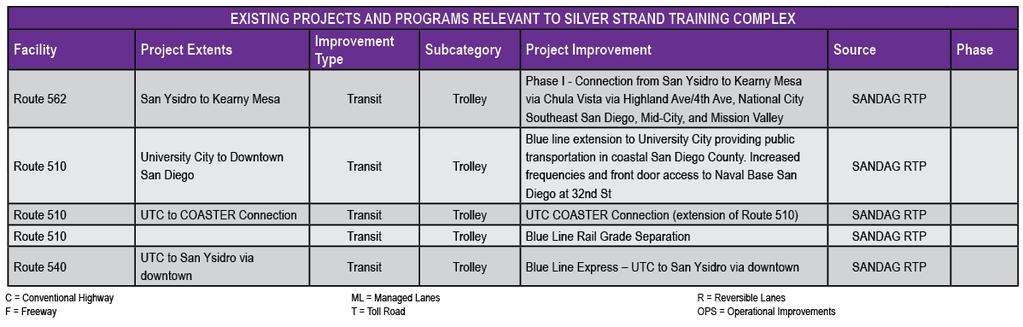
22 Relevant Projects & Programs for NBC 22

23 23

24 24

25 25
26 26

27 27
28 28

29 29

30 30
Naval Base Coronado. Figure 1. Naval Base Coronado location in the region
 Naval Base Coronado Naval Base Coronado (NBC) is a hub for US naval activity and provides a shore-based platform for helicopters, aircraft carriers, SEAL Teams, and other ashore and afloat commands. NBC
Naval Base San Diego. NBSD 32 nd Street Facility. Base Overview. Figure 1. Naval Base San Diego location in the region
 Naval Base San Diego Naval Base San Diego (NBSD) is comprised of the following campuses: 32nd Street Facility Naval Base (known as NBSD), Broadway Complex in Downtown San Diego, and the Naval Medical Center
Circulation in Elk Grove includes: Motor vehicles, including cars and trucks
 Circulation, as it is used in this General Plan, refers to the many ways people and goods move from place to place in Elk Grove and the region. Circulation in Elk Grove includes: Motor vehicles, including
Mission Bay Loop (MBL) Public Meeting
 Public Meeting") Mission Bay Loop (MBL) Public Meeting La Scuola Internazionale di San Francisco, November 18, 2014 Frequently Asked Questions 1. When would construction have to start before the SFMTA loses TIGER funds?
Mission Bay Loop (MBL) Public Meeting La Scuola Internazionale di San Francisco, November 18, 2014 Frequently Asked Questions 1. When would construction have to start before the SFMTA loses TIGER funds?
2018 Transportation Survey October 17, Prepared by:
 Transportation Survey October 17, Prepared by: Overview Methodology Systemwide results Strengths/Weaknesses by mode Importance of possible improvements Conclusions Methodology 500 Chittenden County residents
Providence Downtown Transit Connector STAKEHOLDER MEETING #2. Stakeholder Meeting #1 October 24, 2016
 Providence Downtown Transit Connector STAKEHOLDER MEETING #2 Stakeholder Meeting #1 October 24, 2016 February 2017 1 AGENDA 1 DTC Goals and Expectations 2 Street Design Concepts 3 Potential Benefits and
Solana Beach Comprehensive Active Transportation Strategy (CATS)
") Solana Beach Comprehensive Active Transportation Strategy (CATS) 3.0 Goals & Policies The Solana Beach CATS goals and objectives outlined below were largely drawn from the Solana Beach Circulation Element
Solana Beach Comprehensive Active Transportation Strategy (CATS) 3.0 Goals & Policies The Solana Beach CATS goals and objectives outlined below were largely drawn from the Solana Beach Circulation Element
MCTC 2018 RTP SCS and Madera County RIFP Multi-Modal Project Eval Criteria GV13.xlsx
 MCTC 8 RTP SCS and Madera County RIFP Multi-Modal Project Eval Criteria GV.xlsx Madera County Transportation Commission Regional Transportation Plan / Sustainable Communities Strategy Multi-Modal Project
Key objectives of the survey were to gain a better understanding of:
 3 COMMUNITY INPUT Community input is an essential part of corridor studies. For the SR 87 corridor study, VTA staff conducted an extensive online survey of people living and commuting along the corridor.
Downtown BRT Corridor Alternatives Review: 1 st, 2 nd, 3 rd and 4 th Avenue. Bus Rapid and Conventional Transit Planning and Design Services
 Downtown BRT Corridor Alternatives Review: 1 st, 2 nd, 3 rd and 4 th Avenue Bus Rapid and Conventional Transit Planning and Design Services City of Saskatoon February 2018 Project Team HDR Corporation
WELCOME. Stakeholder Involvement Group Meeting #2 Round Lake Public Works October 24, 2018
 WELCOME Stakeholder Involvement Group Meeting #2 Round Lake Public Works October 24, 2018 MEETING AGENDA 1. Welcome and Introductions 2. Study Progress Update 3. Problem Statement 4. Technical Analysis
Highway 217 Corridor Study. Phase I Overview Report
 Highway 217 Corridor Study Phase I Overview Report November 3, 24 BACKGROUND AND OVERVIEW Study purpose The Highway 217 Corridor Study is developing multi-modal transportation solutions for traffic problems
Santa Clara I-280 CORRIDOR STUDY
 Santa Clara I-280 CORRIDOR STUDY OCTOBER 2017 PREPARED BY: 1.1 Background The I-280 Corridor Study within Santa Clara County is a high-level highway planning study led by the Santa Clara VTA, in partnership
VIVA RETIREMENT COMMUNITIES OAKVILLE TRAFFIC IMPACT STUDY
 VIVA RETIREMENT COMMUNITIES OAKVILLE TRAFFIC IMPACT STUDY VIVA RETIREMENT COMMUNITIES OAKVILLE TRAFFIC IMPACT STUDY DECEMBER 2012 READ, VOORHEES & ASSOCIATES TORONTO, ONTARIO Read, Voorhees & Associates
Purpose and Need. Chapter Introduction. 2.2 Project Purpose and Need Project Purpose Project Need
 Chapter 2 Purpose and Need 2.1 Introduction The El Camino Real Bus Rapid Transit (BRT) Project (Project) would make transit and other transportation improvements along a 17.6-mile segment of the El Camino
Typical Rush Hour Commute. PennyforTransportation.com
 Typical Rush Hour Commute In the News Overview of the Plan Collaborative plan with projects in every community Prioritizing connectivity and congestion relief Dedicated transportation-specific funding;
CHAPTER 3. Transportation and Circulation
 CHAPTER 3 Transportation and Circulation 3.0 TRANSPORTATION AND CIRCULATION This chapter evaluates traffic circulation, transit, parking, pedestrian, bicycle, and rail operational conditions in the Project
Board-Approved Funding Awards for Cycle 4 Active Transportation Grant Program Projects (in Order of Project Rankings) Approved on
 Approved on") CAPITAL Large Category Projects Board-Approved Funding Awards for Cycle 4 Active Transportation Grant Program Projects (in Order of Project Rankings) Approved on 07-27-18 1 La Mesa University Ave Pedestrian
CAPITAL Large Category Projects Board-Approved Funding Awards for Cycle 4 Active Transportation Grant Program Projects (in Order of Project Rankings) Approved on 07-27-18 1 La Mesa University Ave Pedestrian
1 st and 2 nd Street Couplet FAQ s
 1 st and 2 nd Street Couplet FAQ s Q. Will the proposed roundabout at Flume/2nd/1 st Streets affect access to businesses nearby?... 2 Q. What if the project isn t received well by the community after construction?...
Transportation Element
 The paradox of transportation in the late 20 th Century is that while it became possible to travel to the moon, it also became impossible, in many cases, to walk across the street. Joell Vanderwagen Vision:
TRAFFIC IMPACT ANALYSIS
 TRAFFIC IMPACT ANALYSIS FOR THE CHAMPAIGN UNIT#4 SCHOOL DISTRICT PROPOSED HIGH SCHOOL (SPALDING PARK SITE) IN THE CITY OF CHAMPAIGN Final Report Champaign Urbana Urbanized Area Transportation Study 6/24/2014
EXECUTIVE SUMMARY... vii 1 STUDY OVERVIEW Study Scope Study Area Study Objectives
 Contents EXECUTIVE SUMMARY... vii 1 STUDY OVERVIEW... 1-1 1.1 Study Scope... 1-1 1.2 Study Area... 1-1 1.3 Study Objectives... 1-3 2 EXISTING CONDITIONS... 2-1 2.1 Existing Freeway Conditions... 2-4 2.1.1
Northbound San Jose Avenue & I-280 Off-Ramp Road Diet Pilot Project
 Project Overview Fed by a two-lane Interstate-280 (I-280) off-ramp, high vehicular volumes and speeds are longstanding issues along San Jose Avenue. Residents in the surrounding neighborhoods have expressed
North Coast Corridor:
 North Coast Corridor: Connecting People, Transportation & Environment Legislative Hearing: 11.8.10 1 North Coast Corridor Region s Lifeline A Regional Strategy Mobility, Economy & Environment North Coast
Appendix T-2: Transportation Facilities Inventory
 Appendix T-2: Transportation Facilities Inventory Roads, Highways and Bridges The Georgia Department of Transportation (GDOT) maintains centerline mile measures for all counties in Georgia based on functional
January Project No
 January 13 2015 Project No. 5070.05 Neil Connelly, Director University of Victoria, Campus Planning and Sustainability PO Box 1700 STN CSC Victoria, BC V8P 5C2 Dear Neil: Re: UVic 2014 Traffic Final Report
List of Attachments. Location Map... Site Plan... City of Lake Elsinore Circulation Element... City of Lake Elsinore Roadway Cross-Sections...
 List of Attachments Exhibits Location Map... Site Plan... City of Lake Elsinore Circulation Element... City of Lake Elsinore Roadway Cross-Sections... Existing Lane Geometry and Traffic Controls... Existing
SOLANA BEACH BICYCLE TRANSPORTATION PLAN SECOND ADDENDUM
 SOLANA BEACH BICYCLE TRANSPORTATION PLAN SECOND ADDENDUM Prepared by the City of Solana Beach January 2005 Introduction In June of 1993, the Solana Beach City Council adopted a Bikeway Master Plan as directed
LSC TRANSPORTATION CONSULTANTS, INC. 516 North Tejon Street Colorado Springs, CO (719) FAX (719)
 FAX (719)") LSC TRANSPORTATION CONSULTANTS, INC. 516 North Tejon Street Colorado Springs, CO 80903 (719) 633-2868 FAX (719) 633-5430 E-mail: lsc@lsccs.com May 15, 2009 Mr. Davis Farrar Western Slope Consulting, LLC
LSC TRANSPORTATION CONSULTANTS, INC. 516 North Tejon Street Colorado Springs, CO 80903 (719) 633-2868 FAX (719) 633-5430 E-mail: lsc@lsccs.com May 15, 2009 Mr. Davis Farrar Western Slope Consulting, LLC
4 MOBILITY PLAN. Mobility Plan Objectives. Mobility Context. 1. Integrate with Local and Regional Transit Improvements
 Harbor Mixed Use CHAPTER Transit Corridor 4: Mobility Plan 4 MOBILITY PLAN Mobility Plan Objectives The Harbor Corridor Plan seeks to expand and improve the ways that people move along and through the
Berkeley Strategic Transportation Plan A-76
 Berkeley Strategic Transportation Plan A-76 Appendices 1. A Team Effort 2. Where We ve Been A-11 Berkeley Strategic Transportation Plan Alameda County Transportation Plan Alameda County will be served
Focused Traffic Analysis for the 200 Nellen Avenue Project
 March 13, 2017 Mr. Phil Boyle Town of Corte Madera 300 Tamalpais Drive Corte Madera, CA 94976-0159 Focused Traffic Analysis for the 200 Nellen Avenue Project Dear Mr. Boyle; W-Trans has completed a focused
CONNECTING PEOPLE TO PLACES
 CONNECTING PEOPLE TO PLACES 82 EAST BENCH MASTER PLAN 07 Introduction The East Bench transportation system is a collection of slow moving, treelined residential streets and major arteries that are the
C C C
 C-012-001 Thank you for your support for the creation of new public space and nonmotorized access between downtown and the waterfront through the Overlook Walk, the East-West Connections, and the Promenade.
ROADSOADS CONGESTION HAMPTON SYSTEMYSTEM MANAGEMENT. Part II Roadway Congestion Analysis Mitigation Strategies and Evaluation
 HAMPTON ROADSOADS CONGESTION MANAGEMENT SYSTEMYSTEM Part II Roadway Congestion Analysis Mitigation Strategies and Evaluation Presented by: Dwight Farmer, PE Deputy Executive Director, Transportation April
Memorandum. Sunday, July 13, Saturday, July 19, 2014
 Memorandum To: David Lowin, Brooklyn Bridge Park Corporation From: Daniel Schack, AICP, PTP Date: Re: Brooklyn Bridge Park Pier 5/6 Loop Road Traffic Study Project No: 14-01-2407 At the request of Brooklyn
Chapter 2: Standards for Access, Non-Motorized, and Transit
 Standards for Access, Non-Motorized, and Transit Chapter 2: Standards for Access, Non-Motorized, and Transit The Washtenaw County Access Management Plan was developed based on the analysis of existing
APPENDIX E: Transportation Technical Report
 New Jersey Pennsylvania Lackawanna Cut-Off Passenger Rail Service Reston Project Environmental Assessment APPENDIX E: Transportation Technical Report E.1 Introduction As part of the overall environmental
95 th Street Corridor Transportation Plan. Steering Committee Meeting
 95 th Street Corridor Transportation Plan Steering Committee Meeting August 11, 2014 PROJECT OBJECTIVES Develop a Transportation and Economic Plan for the 95 th Street Corridor Improve public transit efficiency
TRAFFIC MANAGEMENT PLAN
 292 84 140440 TRAFFIC MANAGEMENT PLAN The purpose of the Traffic Management Plan (TMP) is to have established procedures for traffic flow and circulation around the elementary school related to student
APPENDIX G: INTERSECTION NEEDS AT OKEECHOBEE BOULEVARD
 APPENDIX G: INTERSECTION NEEDS AT OKEECHOBEE BOULEVARD INTERSECTION NEEDS AT SR 7 and OKEECHOBEE BOULEVARD SR 7 Extension Project Development and Environment (PD&E) Study From Okeechobee Boulevard (SR
Hidden Oaks Elementary School
 Hidden Oaks Elementary School SCHOOL ROUTE PLAN For HIDDEN OAKS ELEMENTARY SCHOOL LOCATION 13 ORANGE COUNTY Prepared for: ORANGE COUNTY SCHOOL ASSESSMENT PROGRAM ORANGE COUNTY PUBLIC WORKS Traffic Engineering
PEDESTRIAN ACTION PLAN
 ATTACHMENT 2 CITY OF SANTA MONICA PEDESTRIAN ACTION PLAN CITY OF SANTA MONICA PEDESTRIAN ACTION PLAN This page intentionally left blank EXECUTIVE SUMMARY CHAPTER 1 EXECUTIVE SUMMARY Setting the Stage
INFRASTRUCTURE: Using the Grid to Create a more Self-Sustaining Downtown. Studio Spring 2013
 EMERGENT FUTURES The San Diego Section of the American Society of Civil Engineers (ASCE) released a new report, the 2012 San Diego County Infrastructure Report Card. Since the last San Diego Report Card
Employment 8,881 17,975 9,094. Households 18,990 31,936 12,946
 This section describes the future transportation environment of the UW Tacoma campus and surrounding area. A description of the future conditions on campus in terms of the street system, traffic and intersection
11,000. P.M. Peak Hour Vehicles/Hour 10,000 9,000 8,000. Year
 CONGESTION RELIEF TASK FORCE The problem today With traffic levels hampering downtown circulation, and long delays in west Salem, policy makers are evaluating potential transportation infrastructure, programs,
CITY OF COCOA BEACH 2025 COMPREHENSIVE PLAN. Section VIII Mobility Element Goals, Objectives, and Policies
 CITY OF COCOA BEACH 2025 COMPREHENSIVE PLAN Section VIII Mobility Element Goals, Objectives, and Policies Adopted August 6, 2015 by Ordinance No. 1591 VIII MOBILITY ELEMENT Table of Contents Page Number
CPC Parking Lot Riverside Drive. Transportation Rationale
 CPC Parking Lot Transportation Rationale Prepared By: NOVATECH Suite 200, 240 Michael Cowpland Drive Ottawa, Ontario K2M 1P6 September 2015 Novatech File: 114093 Ref: R-2015-153 Table of Contents 1.0 INTRODUCTION...
Table #6 VISION CHARACTERISTICS
 Table #6 VISION White Flint is a place to live, work, play, shop, and walk with sufficient density to encourage quality redevelopment. Vibrant streets and consistent streetscapes are important. CHARACTERISTICS
North Shore Transportation Improvement Strategy
 North Shore Transportation Improvement Strategy Preliminary, Near-term Recommendation 2016 April Transportation Improvement Strategy (TIS) Comprehensive and Analytical A multi-modal transportation strategy
TRANSPORTATION TRAINING TOPICS. April 6, 2010
 TRANSPORTATION TRAINING TOPICS April 6, 2010 Roles of Transportation Providers Context and Policy Makers Division of Transportation and Traffic Other City Operations Other Transportation Operators CMA
Waterford Lakes Small Area Study
 Waterford Lakes Small Area Study Existing Traffic Conditions PREPARED FOR: ORANGE COUNTY PUBLIC WORKS DEPARTMENT TRAFFIC ENGINEERING DIVISION ORLANDO, FLORIDA PREPARED WITH: INWOOD CONSULTING ENGINEERS
Lake Whitney Elementary School
 Lake Whitney Elementary School SCHOOL ROUTE PLAN For LAKE WHITNEY ELEMENTARY SCHOOL LOCATION 18 ORANGE COUNTY Prepared for: ORANGE COUNTY SCHOOL ASSESSMENT PROGRAM ORANGE COUNTY PUBLIC WORKS Traffic Engineering
I-105 Corridor Sustainability Study (CSS)
") I-105 Corridor Sustainability Study (CSS) Metro Streets and Freeways Subcommittee March 21, 2019 Gary Hamrick Cambridge Systematics, Inc. I-105 CSS Project History & Background Funded by Caltrans Sustainable
I-105 Corridor Sustainability Study (CSS) Metro Streets and Freeways Subcommittee March 21, 2019 Gary Hamrick Cambridge Systematics, Inc. I-105 CSS Project History & Background Funded by Caltrans Sustainable
WELCOME Public Information Centre
 WELCOME Public Information Centre Fernforest Drive Brampton Soccer Centre Community Room #2 Tuesday January 19, 2016 6:30 p.m.to 9:00 p.m. Please sign in Neighbourhood Traffic Calming Guide Background
o n - m o t o r i z e d transportation is an overlooked element that can greatly enhance the overall quality of life for the community s residents.
 N o n - m o t o r i z e d transportation is an overlooked element that can greatly enhance the overall quality of life for the community s residents. 84 Transportation CHAPTER 11 INTRODUCTION Transportation
REDWOOD CITY STREETCAR - ALTERNATIVES ANALYSIS
 REDWOOD CITY STREETCAR - ALTERNATIVES ANALYSIS The purpose of this document is to ennumerate the analysis of alternatives for a streetcar along the Broadway Corriodor of Redwood City. The six alternatives
Classification Criteria
 SCHEDULE D TO RECOMMENDED OFFICIAL PLAN AMENDMENT NO. 40 SCHEDULE C-4 Road Criteria Criteria Traffic Service Objective Land Service/Access Typical Daily Traffic Volume Flow characteristics Travel Speed
Where We Live and Work Today
 San Diego Forward: The 2019-2050 Regional Plan Network Concepts Transportation Committee Item 4 October 19, 2018 Where We Live and Work Today 2018 2 2019 Regional Plan Transportation Committee Item 4 October
Appendix C. NORTH METRO STATION AREA TRAFFIC IMPACT STATEMENT 88th Avenue Station
 Appendix C NORTH METRO STATION AREA TRAFFIC IMPACT STATEMENT 88th Avenue Station Prepared for: Regional Transportation Department and URS Corporation as part of the North Metro EIS David Evans and Associates,
Existing Transportation System
 < Open for Additional Text Transportation System Existing Transportation System This section describes vehicular transportation associated with Children s. transportation are described in a separate section
Tunnel Reconstruction South 5 th Street Association October 16, 2018
 Tunnel Reconstruction South 5 th Street Association October 16, 2018 Reconstructing the Tunnel 2 Service During Tunnel Reconstruction April 2019 through July 2020 3 Projected Cross River Travel Paths of
Bicycle Facilities Planning
 Bicycle Facilities Planning Overview Types of Cyclists Purpose for Riding Types of Facilities Bike Lanes Bicycle Boulevards Cycle Tracks Intersections Signals Signing and Marking Discussion Types of Bicyclists
Magnolia Place. Traffic Impact Analysis. Prepared for: City of San Mateo. Prepared by: Hexagon Transportation Consultants, Inc.
 Magnolia Place Traffic Impact Analysis Prepared for: City of San Mateo Prepared by: Hexagon Transportation Consultants, Inc. Updated January 4, 2010 Table of Contents 1. Introduction...1 2. Existing Conditions...6
Traffic Study North Shore School District 112
 Traffic Study North Shore School District 112 Proposed Expansion of Northwood Junior High School Prepared By: May 1, 2015 1. Introduction Kenig, Lindgren, O Hara, Aboona, Inc. (KLOA, Inc.) has been retained
AGENDA ITEM G-2 Public Works
 AGENDA ITEM G-2 Public Works STAFF REPORT City Council Meeting Date: 12/6/2016 Staff Report Number: 16-214-CC Regular Business: Approve the Oak Grove University Crane Bike Improvement Concept Plan, authorize
Speed Limits Study and Proposal. Public Input Session: 8/14/13
 Speed Limits Study and Proposal Public Input Session: 8/14/13 Why is Decatur a unique place for this project? First Community Transportation Plan in the nation with a Health Impact Assessment. Strong sense
TECHNICAL MEMORANDUM. Introduction
 TECHNICAL MEMORANDUM To: From: John M. Welsh Chris Furlong AHC, Inc. Andrew T. Smith, P.E. Edward Y. Papazian, P.E. Kimley-Horn and Associates, Inc. Date: July 6, 2017 Subject: 200 9 th reet South Redevelopment
City of Wayzata Comprehensive Plan 2030 Transportation Chapter: Appendix A
 A1. Functional Classification Table A-1 illustrates the Metropolitan Council s detailed criteria established for the functional classification of roadways within the Twin Cities Metropolitan Area. Table
Existing Transportation System
 < Please Open Page for Additional Text Transportation System Existing Transportation System This section describes vehicular transportation associated with Children s. Pedestrian and other nonmotorized
3.0 PROJECT DESCRIPTION
 The following section of the Draft EIR contains a description of the proposed Elk Grove Boulevard/SR 99 Interchange Modification project, consistent with the requirements of CEQA Guidelines Section 15124.
TRANSPORTATION & MOBILITY
 TRANSPORTATION & MOBILITY ROADWAY SYSTEM There are approximately 40 miles of roadways in Manitou Springs. For planning purposes, roadways are typically assigned a functional classification which defines
State Highway 44/State Street High Capacity Corridor
 Background State Highway 44/State Street runs from I-84 in Canyon County through parts of the cities of Middleton, Star, Eagle, and Garden City to downtown Boise. It is a commuter route from several communities
Chapter 4 Transportation Strategies to Support Growth
 City of Brantford Chapter 4 Transportation Strategies to Support Growth TABLE OF CONTENTS 4.1 DESIGNING A TRANSPORTATION STRATEGY... 1 4.2 STRATEGIES TO INCREASE SUPPLY... 2 4.2.1 Optimizing the Existing
See Figure 38, Existing Nonmotorized Connections.
 Nonmotorized Connections Existing Nonmotorized Connections Pedestrian, vehicle and bike traffic access and movements are confined primarily to Penny Drive on campus. Due to the steep slope along the length
City of Davenport CitiBus Public Transportation Study. April 2015
 City of Davenport CitiBus Public Transportation Study April 2015 Overview Project Background Key Findings CitiBus Service Allocation Policy Discussion 2 Project Background 3 About CitiBus Operates 17 routes
MOBILITY WORKSHOP. Joint City Council and Transportation Commission May 5, 2014
 MOBILITY WORKSHOP Joint City Council and Transportation Commission May 5, 2014 Review of General Plan M-1 Develop world-class transit system M-3 Maintain/enhance pedestrian-oriented City M-4 Create comprehensive
Bay to Bay Boulevard Complete Streets Project
 Bay to Bay Boulevard Complete Streets Project Dale Mabry Highway to Bayshore Boulevard February 08, 2018 Photo Source: Tampa Bay Times Alessandra Da Pra Meeting Format Introduction Resurfacing Information
Transportation 6. A. Transit Center Circulation and Access. 1. Transit Center Circulation
 Transportation 6 This chapter describes the transportation system in and around the Hillsdale Station Area, with a focus on the Transit Center at the relocated Hillsdale Caltrain Station. The transportation
Mission Street Medical Office Development
 reet Medical Office Development Traffic Impact Analysis Prepared for: Palo Alto Medical Foundation February 23, 2012 Hexagon Office: 7888 Wren Avenue, Suite B121 Gilroy, CA 95020 Hexagon Job Number: 11RD11
June 3, Attention: David Hogan City of San Mateo 330 W. 2oth Avenue San Mateo, CA 94403
 June 3, 2015 Attention: David Hogan City of San Mateo 330 W. 2oth Avenue San Mateo, CA 94403 Regarding: PA # 15-030, Bridgepointe Shopping Center 2202 Bridgepointe Parkway, APN 035-466-10 Dear David: Enclosed
Draft North Industrial Area-Wide Traffic Plan
 Summary of North Industrial and Hudson Bay Industrial Recommended Improvements Table 1. Summary of s Item Location 1 2 3 4 5 6 7 8 9 10 11 12 Millar Ave north of 51st St Super 8 Motel back lane 400 Block
HIGHBURY AVENUE/HAMILTON ROAD INTERSECTION IMPROVEMENTS PUBLIC INFORMATION CENTRE 1 MAY 14, 2015
 HIGHBURY AVENUE/HAMILTON ROAD INTERSECTION IMPROVEMENTS Municipal Class Environmental Assessment PUBLIC INFORMATION CENTRE 1 MAY 14, 2015 ACCESSIBILITY Under the Accessibility Standards 2015 for Customer
SECTION 1 - TRAFFIC PLANNING
 SECTION 1 - TRAFFIC PLANNING 1.1 TRAFFIC OPERATIONS 1.1.1 Roadway Functional Classification The Multnomah County Comprehensive Framework Plan s Policy 34: Trafficways and the Functional Classification
Eliminate on-street parking where it will allow for a dedicated bus only lane %
 Traffic Dashboard Priorities Survey Responses Introduction 1) Are you familiar with bus rapid transit (BRT)? a. No, BRT is new to me. 597 23.5% b. I ve heard of BRT, but I don t know much about it. 1,136
HENDERSON DEVELOPMENT 213, 217, 221, 221 ½, 223 HENDERSON AVENUE and 65 TEMPLETON STREET OTTAWA, ONTARIO TRANSPORTATION OVERVIEW.
 HENDERSON DEVELOPMENT 213, 217, 221, 221 ½, 223 HENDERSON AVENUE and 65 TEMPLETON STREET OTTAWA, ONTARIO TRANSPORTATION OVERVIEW Prepared for: 2294170 Ontario Inc. February 2, 2017 117-652 Report_1.doc
El Paso County 2040 Major Transportation Corridors Plan
 El Paso County 2040 Major Transportation Corridors Plan Connect-our-County Online Transportation User Survey Preliminary Results June 24, 2010 Years of Residence 2. How many years have you LIVED HERE?
Strategies to keep people and goods moving in and through Seattle
 Strategies to keep people and goods moving in and through Seattle The Seattle Squeeze and the #Realign99 Closure 2018-2024 Commute Seattle Employer Department Open of Transportation House December 7, 2018
TABLE OF CONTENTS TABLE OF CONTENTS... I APPENDICES... III LIST OF EXHIBITS... V LIST OF TABLES... VII LIST OF ABBREVIATED TERMS...
 TABLE OF CONTENTS TABLE OF CONTENTS... I APPENDICES... III LIST OF EXHIBITS... V LIST OF TABLES... VII LIST OF ABBREVIATED TERMS... IX 1 INTRODUCTION... 1 1.1 Project Overview... 1 1.2 Analysis Scenarios...
BEAR CREEK PARK AND RIDE
 BEAR CREEK PARK AND RIDE 7760 178th Pl NE, Redmond, WA 98052 700 Average weekday transit boardings 283 Parking spaces Owned by King County Metro Served by Sound Transit and King County Metro Bear Creek
Bicycle Master Plan Goals, Strategies, and Policies
 Bicycle Master Plan Goals, Strategies, and Policies Mobilizing 5 This chapter outlines the overarching goals, action statements, and action items Long Beach will take in order to achieve its vision of
2.0 Existing Conditions
 20 2.0 Existing Conditions 2.1 Land Use, Future Growth Patterns, Physical Barriers Geographic Overview Sutter County s land use pattern is characterized by extensive agricultural areas, significant natural
New Seward and 36 th Avenue Intersection Conceptual Design
 University of Alaska Anchorage New Seward and 36 th Avenue Intersection Conceptual Design Prepared By: Zaid S. Hussein Dana Menendez Galen Jones Civil Engineering Department Prof. Osama Abaza CE A404 Highway
Bridge Street Corridor Study Report
 Bridge Street Corridor Study Report Prepared for: Prepared by: BRIDGE STREET CORRIDOR STUDY REPORT PREPARED FOR: CITY OF ARROYO GRANDE COMMUNITY DEVELOPMENT DEPARTMENT 300 EAST BRANCH STREET ARROYO GRANDE,
EUCLID AVENUE PARKING STUDY CITY OF SYRACUSE, ONONDAGA COUNTY, NEW YORK
 EUCLID AVENUE PARKING STUDY CITY OF SYRACUSE, ONONDAGA COUNTY, NEW YORK CITY OF SYRACUSE DEPARTMENT OF PUBLIC WORKS 1200 CANAL STREET EXTENSION SYRACUSE, NEW YORK 13210 DRAFT REPORT DATE: November 13,
EXECUTIVE SUMMARY OF CALEDON TRANSPORTATION NEEDS STUDY
 EXECUTIVE SUMMARY OF CALEDON TRANSPORTATION NEEDS STUDY The Caledon Transportation Needs Study has been undertaken as a joint project by the Town of Caledon and the Region of Peel to determine the existing
MEMORANDUM. Sutter Street Bicycle Lanes, Stockton, CA SF
 MEMORANDUM Date: To: From: Subject: PURPOSE Anthony J. Lopes, Siegfried Engineering Christine Carey & Matthew Ridgway, Fehr & Peers Sutter Street Bicycle Lanes, Stockton, CA SF09-0468 The City of Stockton
BUILDING THE CASE FOR TRAVEL OPTIONS IN WASHING TON COUNTY. Image: Steve Morgan. Image: Steve Morgan
 BUILDING THE CASE FOR TRAVEL OPTIONS IN WASHING TON COUNTY Image: Steve Morgan Image: Steve Morgan Image: TriMet Image: TriMet WHAT ARE TRAVEL OPTIONS PROGRAMS? Travel options programs encourage residents,
Chapter 5 Future Transportation
 Chapter 5 Future Transportation The Future Land Use Plan identifies the desired land use designations. The land uses desired for Crozet depend, in large part, on the success of the transportation system,
Caltrans Sloat Boulevard Pedestrian Safety Project Response to Community Questions, Comments & Concerns
 Caltrans Sloat Boulevard Pedestrian Safety Project Response to Community Questions, Comments & Concerns Revised: May 10, 2016 The California Department of Transportation (Caltrans) is planning various