Action Plan and Summary for Roads to Gravel
|
|
|
- Peter Rice
- 6 years ago
- Views:
Transcription


1 Impact of Energy Sector and Heavy Commercial Development Action Plan and Summary for Roads to Gravel Research Report RR Prepared for Texas Department of Transportation Maintenance Division Prepared by L. G. Passmore August 2013
2
3 TABLE OF CONTENTS Page LIST OF FIGURES... II LIST OF TABLES... II HEAVY COMMERCIAL IMPACTS... 1 I: ACCESS INCREASE TRAFFIC VOLUMES... 1 II: MONITOR / MAINTAIN / PAVED... 1 III: LOAD POST... 2 IV: CONVERT TO GRAVEL... 2 V: MONITOR / MAINTAIN / GRAVEL... 2 FACTS... 3 FOUR YEAR PLAN... 3 SUPPLEMENTAL INFORMATION... 4 I: SELECTION CRITERIA (FOR CONVERSION TO GRAVEL SURFACE):... 4 II: CURRENT ROADWAYS SELECTED FOR POTENTIAL CONVERSION TO GRAVEL:... 4 APPENDIX A - PMIS CONDITION SCORES, PMIS COMPARISON, IMAGES, MAINTENANCE EXPENDITURES, FIGURES, CURRENT IMAGES... A-1 FM A-2 FM A-6 FM A-10 FM A-14 FM A-18 FM A-20 FM A-23 FM A-27 FM A-30 FM A-33 FM A-37 I 37 E FR... A-41 I 37 W FR... A-45 APPENDIX B - UNPAVED ROADWAY SIGNING GUIDANCE... B-1 MEMORANDUM... B-2 RR i
4 LIST OF FIGURES Figure 1. Maintenance Expenditures/Mile/Year... 1 Page LIST OF TABLES Table 1. Current Roadways Selected for Potential Conversion Page RR ii

5 HEAVY COMMERCIAL IMPACTS Access - Increase Traffic Load Post Monitor / Maintain / Paved Convert Monitor / Maintain / Gravel I: ACCESS INCREASE TRAFFIC VOLUMES PROBLEM: The roadways are seeing a drastic increase in traffic volumes and percent trucks. SOLUTION: Evaluate the cause of the problem and determine if the root cause, increased truck volumes, can be mitigated to reduce the impacts. ACTION: New procedures on granting commercial driveway access have been implemented. II: MONITOR / MAINTAIN / PAVED PROBLEM: Data from candidate roadway segments indicates an increase in maintenance cost at a rate of $8,500 / mile / year, over the last two years, to maintain a paved road segment. These roadways were designed/built 15+ years ago and are experiencing truck volumes they were not designed for. Figure 1. Maintenance Expenditures/Mile/Year RR
6 SOLUTION: Evaluate the roadway. Perform a pavement distress evaluation to obtain a current condition score and obtain accurate traffic data. ACTION: Based on a risk analysis in the field, conduct maintenance on the roadway segment to address safety concerns. III: LOAD POST PROBLEM: The pavement distress evaluation and traffic data indicates a very low condition score and % trucks > 20%. SOLUTION: Determine if any further evaluation is needed and examine the limits of the roadway segments seeing the impacts. ACTION: Place load posting restrictions. IV: CONVERT TO GRAVEL PROBLEM: The roadway segment has deteriorated to a level that safety has become a major concern. SOLUTION: Evaluation is made to determine scope and limits of converting a roadway segment from paved to gravel. Field inspections of potential roadway conversions indicate that approximately 3 of raw material will need to be added to obtain desired travel way width. ACTION: Begin conversion to widen gravel road segments with internal forces, reduce posted speed, and increase safety. V: MONITOR / MAINTAIN / GRAVEL PROBLEM: The roadway segment does not meet the traditional drivers expectations for an on-system facility. SOLUTION: Conduct maintenance on the gravel segment at a cost to the agency of $10,000/mile/year based on estimating one day per month of blading operations. ACTION: Leave this gravel roadway in operation and track operational aspects. RR
7 FACTS Cost to maintain a debilitating paved road (per actual MMIS data) Cost to maintain a gravel road (Est: blading, TMA, light duty truck, water truck) Cost to convert a paved road to gravel (Est: 3 material on 28 rdwy, road grader work) Cost to build a paved energy sector road (28 rdwy, 2-CST) $33,500/mile/year $10,000/mile/year $40,000/mile $400,000/mile FOUR YEAR PLAN Year 1: Convert to gravel ($40,000/mile) + Maintain ($10,000/mile) Year 2: Maintain ($10,000/mile) Year 3: Maintain ($10,000/mile) Year 4: Maintain ($10,000/mile) + additional base ($20,000/mile) RR
8 SUPPLEMENTAL INFORMATION I: SELECTION CRITERIA (FOR CONVERSION TO GRAVEL SURFACE): Level of safety is unacceptable. Roadway condition is beyond a level that traditional maintenance operations can keep in acceptable condition. Roadway is experiencing significant increase in truck volumes. Functional class 6 ineligible for construction funds. Roadway has little to no connectivity. Residential density is low. II: CURRENT ROADWAYS SELECTED FOR POTENTIAL CONVERSION TO GRAVEL: Table 1. Current Roadways Selected for Potential Conversion. Safety Action Plan District County Roadway Limits MI CRP Live Oak IH 37 frontage From FM 99 South 3 miles to end of roads maintenance LRD Dimmit FM 1916 From FM 190 to End of Roadway Immediate La Salle LRD (spot repairs 1 mile) FM 469 From IH 35 West to FM Soon LRD Dimmit FM 3252 From FM 186 to End of Roadway LRD Dimmit FM 2688 From US 83 to End of Roadway LRD Dimmit FM 1019 From FM 468 to End of Roadway LRD Dimmit FM 1558 From FM 1019 to End of Roadway LRD Dimmit FM 1867 SH 85 South to End Of Roadway LRD Dimmit FM 186 From FM 3252 to End of Roadway LRD La Salle FM 3408 From IH 35 to End of Roadway LRD Zavala FM1668 From FM 393 to End of Roadway ODA Reeves & Culberson FM 2119 RM The total lane miles proposed to convert immediately is 4.0 miles in the Laredo District (3 miles for FM 1916 and 1 mile for FM 469). The total lane miles proposed to convert immediately is 6.0 miles in the Corpus Christi District (6 miles of frontage road on IH 37). The remaining roadway segments are in a condition to allow conversion as safety concerns increase. Other roadways, not identified on this list, could easily meet the defined selection criteria in the near future. As commercial activity shifts to different regions, different roadways will experience the stress of increased truck loading and damage will occur. The impacts to roadways from these increased commercial activities have been rapidly expanding. RR
9 TxDOT is prepared to adjust to these conditions, re-examine roadway conditions, and reprioritize accordingly. Safety is of utmost importance and will continue to guide our decision making process. RR
10 APPENDIX A - PMIS CONDITION SCORES, PMIS COMPARISON, IMAGES, MAINTENANCE EXPENDITURES, FIGURES, CURRENT IMAGES RR Page A-1
11 FM 186 District: Laredo County: Dimmit Roadway: FM 186 Physical Limits: FM 3252 to End of Roadway Reference Markers: to Length: Data Year: Maintenance Expenditures per Mile ($Thousands): Average PMIS Condition Score: PMIS Condition Decrease: Average PMIS Decrease/Year: -6.0 RR Page A-2

12 RR Page A-3
13 Maintenance Expenditures/Mile/Year Maintenance Expenditures ($Thousands/Mile/Year) Cost/Mile/Year (Weighted Average for Selected Roads) Cost/Mile/Year (FM 186) Year RR Page A-4

14 FM 186 Images -Current RR Page A-5
15 FM 469 District: Laredo County: LaSalle Roadway: FM 469 Physical Limits: IH 35 W to FM 468 Reference Markers: to Length: PMIS Year: Maintenance Expenditures per Mile Average PMIS Condition Score: PMIS Condition Decrease: Average PMIS Decrease/Year: 12.7 RR Page A-6


16 RR Page A-7
17 Maintenance Expenditures ($Thousands/Mile/Year) Maintenance Expenditures/Mile/Year Year Cost/Mile/Year (Weighted Average for Selected Roads) Cost/Mile/Year (FM 469) RR Page A-8


18 FM 469 Images- Current FM 469 LA SALLE COUNTY RR Page A-9
19 FM 1019 District: Laredo County: Dimmit Roadway: FM 1019 Physical Limits: FM 468 to End of Roadway Reference Markers: to Length: PMIS Scores Year: Maintenance Expenditures per Mile ($Thousands): Average PMIS Condition Score: PMIS Condition Decrease: Average PMIS Decrease/Year: 9.7 RR Page A-10

20 RR Page A-11
21 Maintenance Expenditures ($Thousands/Mile/Year) Maintenance Expenditures/Mile/Year Year Cost/Mile/Year (Weighted Average for Selected Roads) Cost/Mile/Year (FM 1019) RR Page A-12


22 FM 1019 Images Current RR Page A-13
23 FM 1558 District: Laredo County: Dimmit Roadway: FM 1558 Physical Limits: FM 1019 to End of Roadway Reference Markers: to Length: Data Year: Maintenance Expenditures per Mile Average PMIS Condition Score: PMIS Condition Decrease: Average PMIS Decrease/Year: 21.4 RR Page A-14


24 RR Page A-15
25 Maintenance Expenditures/Mile/Year Maintenance Expenditures ($Thousands/Mile/Year) Year Cost/Mile/Year (Weighted Average for Selected Roads) Cost/Mile/Year (FM 1558) RR Page A-16

26 FM 1558 Images Current Note: FM 1558 only has edge problems, as seen in this image, at certain driveways. Edge problems on FM 1558 were very minimal away from driveways. RR Page A-17
27 FM 1668 District: Laredo County: Zavala Roadway: FM 1668 Physical Limits: FM 393 to End of Roadway Reference Markers: to Length: PMIS Year: Maintenance Expenditures per Mile Average PMIS Condition Score: PMIS Condition Decrease: Average PMIS Decrease/Year: -3.9 No images available on proview to date. System might still be having issues. Maintenance Expenditures ($Thousands/Mile/Year) Maintenance Expenditures/Mile/Year Year Cost/Mile/Year (Weighted Average for Selected Roads) Cost/Mile/Year (FM 1668) RR Page A-18


28 FM 1668 Images- Current RR Page A-19

29 FM 1867 District: Laredo County: Dimmit Roadway: FM 1867 Physical Limits: SH 85 to South to End of Roadway Reference Markers: to Length: 2.9 PMIS Year: Maintenance Expenditures per Mile Average PMIS Condition Score: PMIS Condition Decrease: Average PMIS Decrease/Year: 6.0 Only 1 year of observations was available RR Page A-20
30 Maintenance Expenditures ($Thousands/Mile/Year) Maintenance Expenditures/Mile/Year Year Cost/Mile/Year (Weighted Average for Selected Roads) Cost/Mile/Year (FM 1867) RR Page A-21

31 FM 1867 Images- Current RR Page A-22
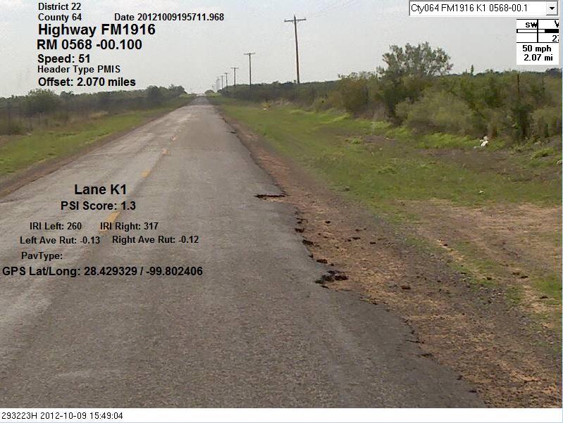
32 FM 1916 District: Laredo County: Dimmit Roadway: FM 1916 Physical Limits: FM 190 to End of Roadway Reference Markers: to Length: PMIS Year: Maintenance Expenditures per Mile Average PMIS Condition Score: PMIS Condition Decrease: Average PMIS Decrease/Year: 13.1 RR Page A-23

33 RR Page A-24
34 Maintenance Expenditures ($Thousands/Mile/Year) Maintenance Expenditures/Mile/Year Year Cost/Mile/Year (Weighted Average for Selected Roads) Cost/Mile/Year (FM 1916) RR Page A-25

35 FM 1916 Images- Current RR Page A-26
36 FM 2119 District: Odessa County: Reeves and Roadway: FM 2119 Physical Limits: to Reference Markers: to Length: PMIS Year: Maintenance Expenditures per Mile Average PMIS Condition Score: PMIS Condition Decrease: Average PMIS Decrease/Year: -3.3 RR Page A-27

37 RR Page A-28
38 Maintenance Expenditures ($Thousands/Mile/Year) Maintenance Expenditures/Mile/Year Year Cost/Mile/Year (Weighted Average for Selected Roads) Cost/Mile/Year (FM 2119) No Current Images for this Roadway RR Page A-29
39 FM 2688 District: Laredo County: Dimmit Roadway: FM 2688 Physical Limits: US 83 to End of Roadway Reference Markers: PMIS 0 Scores to Length: Year: Maintenance Expenditures per Mile ($Thousands): Average PMIS Condition Score: PMIS Condition Decrease: Average PMIS Decrease/Year: RR Page A-30

40 RR Page A-31
41 Maintenance Expenditures ($Thousands/Mile/Year) Maintenance Expenditures/Mile/Year Cost/Mile/Year (Weighted Average for Selected Roads) Cost/Mile/Year (FM 2268) Year No Current Pictures Available for FM 2688 RR Page A-32
42 FM 3252 District: Laredo County: Dimmit Roadway: FM 3252 Physical Limits: FM 186 to End of Roadway Reference Markers: to Length: PMIS Year: Maintenance Expenditures per Mile Average PMIS Condition Score: PMIS Condition Decrease: Average PMIS Decrease/Year: 9.9 RR Page A-33

43 RR Page A-34
44 Maintenance Expenditures ($Thousands/Mile/Year) Maintenance Expenditures/Mile/Year Year Cost/Mile/Year (Weighted Average for Selected Roads) Cost/Mile/Year (FM 3252) RR Page A-35

45 FM 3252 Images- Current RR Page A-36
46 FM 3408 District: Laredo County: La Salle Roadway: FM 3408 Physical Limits: IH 35 to End of Roadway Reference Markers: to Length: PMIS Year: Maintenance Expenditures per Mile Average PMIS Condition Score: PMIS Condition Decrease: Average PMIS Decrease/Year: 12.7 RR Page A-37

47 RR Page A-38
48 Maintenance Expenditures ($Thousands/Mile/Year) Maintenance Expenditures/Mile/Year Year Cost/Mile/Year (Weighted Average for Selected Roads) Cost/Mile/Year (FM 3408) RR Page A-39


49 FM 3408 Images- Current RR Page A-40
50 I 37 E FR District: Corpus County: Live Oak Roadway: I 37 E. FR. Physical Limits: FM 99 to South to End of Reference Markers: to Length: PMIS Scores Year: Maintenance Expenditures per Mile ($Thousands): Average PMIS Condition Score: PMIS Condition Decrease: Average PMIS Decrease/Year: 25.7 RR Page A-41
51 RR Page A-42
52 Maintenance Expenditures ($Thousands/Mile/Year) Maintenance Expenditures/Mile/Year Year Cost/Mile/Year (Weighted Average for Selected Roads) Cost/Mile/Year (I 37 Frontage Roads) RR Page A-43

53 IH-37 FR. E.Images -Current RR Page A-44
54 I 37 W FR District: Corpus County: Live Oak Roadway: I 37 W. FR. Physical Limits: FM 99 to South to End of Reference Markers: to Length: PMIS Scores Year: Maintenance Expenditures per Mile ($Thousands): Average PMIS Condition Score: PMIS Condition Decrease: Average PMIS Decrease/Year: 12.6 RR Page A-45

55 RR Page A-46
56 Maintenance Expenditures ($Thousands/Mile/Year) Maintenance Expenditures/Mile/Year Year Cost/Mile/Year (Weighted Average for Selected Roads) Cost/Mile/Year (I 37 Frontage Roads) RR Page A-47

57 I-37 FR. W. Images Current RR Page A-48
58
59 APPENDIX B - UNPAVED ROADWAY SIGNING GUIDANCE RR Page B-1
60 MEMORANDUM TO: FROM: SUBJECT: District Engineers Toribio Garza, Jr., P.E. Carol T. Rawson, P.E. Signage of Low Volume FM/RM Highways with Pavement Deterioration Caused by Energy Development Energy development in Texas has had significant impact on the state's highway network. While roadways of higher functional classes are typically designed to accommodate heavy traffic, the traffic associated with energy development has been severely impacting rural low volume roadways such as FM and RM highways, causing major damage to the pavement, shoulders, curbs, and traffic signs. Many districts are struggling to maintain the severely damaged roadways. In some cases, low volume FM and RM highways are deteriorating to an unpaved condition and major maintenance is being delayed until energy-related activities subside. Questions are being raised as to how to sign these roadways and how speed limits are affected. The Texas Transportation Code, , does not provide for different prima facie speed limits for gravel/unpaved state highways or state highways with gravel/unpaved sections. However, if the maximum reasonable and safe speed of the roadway is now lower than the statutory speed limit because of its deteriorated condition, we recommend the installation of "Rough Road" signs (W8-8) with an advisory speed plaque (W13-1P). If the centerline is no longer visible on the roadway and cannot be retraced because of the roadway condition, "No Center Stripe" signs (W8-12) with the "Next XX Miles" plaque (W7-3aP) should also be installed. If you have questions, please contact Toribio at (512) or Carol at (512) cc: John A. Barton, P.E., Deputy Executive Director District Maintenance Engineers District Traffic Engineers RR Page B-2
ENERGY SECTOR ROADWAY REPAIR PROJECT. August 15, 2013 Industry Workshop
 ENERGY SECTOR ROADWAY REPAIR PROJECT August 15, 2013 Industry Workshop Safety Moment Sign-in Sheet Exit Locations Gathering Point Directions from Emergency Responders Signal to re-enter the Building or
TEXAS DEPARTMENT OF TRANSPORTATION. Condition of Texas Pavements
 TEXAS DEPARTMENT OF TRANSPORTATION Condition of Texas Pavements PMIS Annual Report FY 2007-2010 Condition of Texas Pavements Pavement Management Information System (PMIS) Annual Report FY 2007-2010 Prepared
ENERGY SECTOR COORDINATION
 ENERGY SECTOR COORDINATION Darin Kosmak, Deputy Director TxDOT Rail Division November 4, 2013 Energy Sector Considerations Existing FM roads not built to handle truck traffic resulting from: Oil & natural
ENGINEERING DRIVER SAFETY INTO PAVEMENT PRESERVATION
 ENGINEERING DRIVER SAFETY INTO PAVEMENT PRESERVATION 2015 TxDOT Short Course Miguel Arellano, P.E. Austin District Pavement Engineer October 13, 2015 Table of Contents 1 Goals: Overall Reduction in Crashes
RURAL HIGHWAY SHOULDERS THAT ACCOMMODATE BICYCLE AND PEDESTRIAN USE (TxDOT Project ) June 7, Presented by: Karen Dixon, Ph.D., P.E.
 June 7, Presented by: Karen Dixon, Ph.D., P.E.") RURAL HIGHWAY SHOULDERS THAT ACCOMMODATE BICYCLE AND PEDESTRIAN USE (TxDOT Project 0-6840) June 7, 2016 Presented by: Karen Dixon, Ph.D., P.E., TTI Team: Kay Fitzpatrick, Raul Avelar, & Subasish Das Project
RURAL HIGHWAY SHOULDERS THAT ACCOMMODATE BICYCLE AND PEDESTRIAN USE (TxDOT Project 0-6840) June 7, 2016 Presented by: Karen Dixon, Ph.D., P.E., TTI Team: Kay Fitzpatrick, Raul Avelar, & Subasish Das Project
South Carolina Department of Transportation. Engineering Directive
 South Carolina Department of Transportation Engineering Directive Directive Number: ED-22 Effective: December 16, 2009 Subject: References: Purpose: This Directive Applies to: Considerations for Bicycle
Pavement Markings (1 of 3)
") Pavement Markings (1 of 3) DESCRIPTION AND DEFINITION Disadvantages Relatively high cost (over typical Crash reduction as yet unknown painted edge line) No tactile effect The STOP AHEAD pavement marking
Pavement Markings (1 of 3) DESCRIPTION AND DEFINITION Disadvantages Relatively high cost (over typical Crash reduction as yet unknown painted edge line) No tactile effect The STOP AHEAD pavement marking
I-20 ODESSA-MIDLAND CORRIDOR STUDY. Public Meeting for Schematic Design
 I-20 ODESSA-MIDLAND CORRIDOR STUDY Public Meeting for Schematic Design The environmental review, consultation, and other actions required by applicable Federal environmental laws for this project are being,
TEXAS DEPARTMENT OF TRANSPORTATION. Condition of Texas Pavements
 TEXAS DEPARTMENT OF TRANSPORTATION Condition of Texas Pavements PMIS Annual Report FY 2008-2011 Condition of Texas Pavements Pavement Management Information System (PMIS) Annual Report FY 2008-2011 Prepared
FY STIP. Austin District. November Quarterly Revisions HIGHWAY STATEWIDE TRANSPORTATION IMPROVEMENT PROGRAM
 FY 2011-2014 STIP STATEWIDE TRANSPORTATION IMPROVEMENT PROGRAM HIGHWAY Austin District November Quarterly Revisions November 2011 FY 2011-2014 Transportation Improvement Program Amendments October 10,
County of Greenville South Carolina. Traffic Calming Program Neighborhood Traffic Education Program and Speed Hump Program
 County of Greenville South Carolina Traffic Calming Program Neighborhood Traffic Education Program and Speed Hump Program (rev) August 2008 I. PURPOSE The potential negative impacts from vehicular traffic
Roadway Design Manual
 Roadway Design Manual Manual Notice Archive by Texas Department of Transportation (512) 302-2453 all rights reserved Manual Notice 2009-1 From: Manual: Mark A. Marek, P.E Roadway Design Manual Effective
Development of Guidelines for Bicycle Use of Controlled Access Facilities in Virginia
 Development of Guidelines for Bicycle Use of Controlled Access Facilities in Virginia VDOT Statewide Bicycle and Pedestrian Advisory Committee Fall Working Group Meeting October 30, 2013 Young-Jun Kweon,
County of Spartanburg South Carolina
 County of Spartanburg South Carolina Traffic Calming Program June 2012 (Revised/Program on Hold) PURPOSE The potential negative impacts from vehicular traffic on residential roads have been a longstanding
APPENDIX L: COST ESTIMATING TOOLS
 APPENDIX L: COST ESTIMATING TOOLS Rural Arterial From LRE MOT * Mobilization * Subtotal Scope Contingency (25%) Total PE Design (15%) CEI (15%) Total Project ** New (2-Lane Roadway) with 5' Paved Shoulders
RAISED MEDIAN EFFECTIVENESS
 RAISED MEDIAN EFFECTIVENESS William E. Frawley, AICP Texas A&M Transportation Institute Access Management Overview Set of Tools to Help Improve Safety and Protect Public Investments in Roadways Balances
This Chapter sets forth the minimum design, technical criteria and specifications to be used in the preparation of all roadway plans.
 4.1 GENERAL This Chapter sets forth the minimum design, technical criteria and specifications to be used in the preparation of all roadway plans. These Roadway Standards are for new construction and modification
Guidelines for Integrating Safety and Cost-Effectiveness into Resurfacing, Restoration, and Rehabilitation Projects
 Guidelines for Integrating Safety and Cost-Effectiveness into Resurfacing, Restoration, and Rehabilitation Projects NCHRP Project 15-50 July 2017 1 Research Objective Develop guidelines for safe and cost-effective
Secondary Road Program
 Secondary Road Program Joint Legislative Transportation Oversight Committee October 5, 2012 1 Secondary Roads Program The Big Picture The Secondary Road System Needs and Project Types Paved and Unpaved
AASHTO Use Only Establishment of a U.S. (Interstate) Route IH 69 Action taken by SCOH: Extension of a U.S. (Interstate)Route
 Route IH 69 Action taken by SCOH: Extension of a U.S. (Interstate)Route") American Association of State Highway and Transportation Officials An Application from the State Highway or Transportation Department of Texas for: Elimination of a U.S. (Interstate) Route AASHTO Use Only
American Association of State Highway and Transportation Officials An Application from the State Highway or Transportation Department of Texas for: Elimination of a U.S. (Interstate) Route AASHTO Use Only
10.0 CURB EXTENSIONS GUIDELINE
 10.0 CURB EXTENSIONS GUIDELINE Road Engineering Design Guidelines Version 1.0 March 2017 City of Toronto, Transportation Services City of Toronto Page 0 Background In early 2014, Transportation Services
Access Management in the Vicinity of Intersections
 Access Management in the Vicinity of Intersections FHWA-SA-10-002 Technical Summary Photo: Ralph Bentley (used with permission) 0 Access Management is: The design, implementation and management of entry
TRAFFIC CONTROL DEVICES FOR LOW VOLUME ROADS
 PART 5. TRAFFIC CONTROL DEVICES FOR LOW VOLUME ROADS TABLE OF CONTENTS Chapter 5A. GENERAL Page Section 5A.1 Function............................................................... 5A-1 5A.2 Application............................................................
Driveway Design Criteria
 Design Manual Chapter 5 - Roadway Design 5L - Access Management 5L-4 Driveway Design Criteria A. General For efficient and safe operations, access drives and minor public street intersections can be improved
CITY OF WEST LAKE HILLS. Forest View Neighborhood Traffic Calming Study
 CITY OF WEST LAKE HILLS 901 South Mopac Expressway Building V, Suite 220 Austin, Texas 78746 Texas P.E. Firm Registration No. F-929 Klotz Associates Final Report Submittal: March 20, 2015 Revised Final
SELECTED ROADWAY CAPACITY ANALYSIS
 CHAPTERFOUR SELECTED ROADWAY CAPACITY ANALYSIS 4.1 SELECTED ROADWAY CAPACITY ANALYSIS Introduction Capacity analysis was performed on six selected roadways within the Dearborn County study area using the
Chapter 3 DESIGN SPECIFICATIONS
 Brampton PathWays Planning and Design Guidelines 27 Chapter 3 DESIGN SPECIFICATIONS 3.1 CLASS 1 MULTI-USE PATH Off-road multi-use trails are the backbone of the Brampton PathWays Network. They are typically
SPECIAL SPECIFICATION 7581 Performance Based Vegetation Management
 2004 Specifications CSJ 6216-60-001 SPECIAL SPECIFICATION 7581 Performance Based Vegetation Management 1. Description. This item will govern for complete vegetation management of highway rightof-way, including
WYDOT DESIGN GUIDES. Guide for. Non-NHS State Highways
 WYDOT DESIGN GUIDES Guide for Non-NHS State Highways 2014 GUIDE FOR Non-NATIONAL HIGHWAY SYSTEM (Non-NHS) STATE HIGHWAYS PRESERVATION REHABILITATION RECONSTRUCTION INTRODUCTION This Guide is directed to
Traffic Impact Memorandum. May 22, 2018
 BISHOP PROFESSIONAL DEVELOPMENT BUILDING Proposed Land-use Change & Parking Modification 3601 SW 31st Street Topeka, Kansas 66614 CFS Project No. 185077 Traffic Impact Memorandum May 22, 2018 Prepared
IH 20 RANGER HILL PUBLIC MEETING
 IH 20 RANGER HILL PUBLIC MEETING AUGUST 25, 2015 IH 20, Eastland County, TX CSJ 0007-06-084 IH 20 from 3.5 mi. East of LP 254 to SH 16 (Ranger Hill) August 25, 2015 Agenda Introductions Purpose of the
Act 47 Exception Application Process (Permitting Bicycle Travel on Freeways)
") Act 47 Exception Application Process (Permitting Bicycle Travel on Freeways) Attached is a revised application process to permit Pedalcycle travel on the shoulders of freeways within the Commonwealth.
Act 47 Exception Application Process (Permitting Bicycle Travel on Freeways) Attached is a revised application process to permit Pedalcycle travel on the shoulders of freeways within the Commonwealth.
Appendix B. Environmental Resource Technical Memorandum. Assessment on Travel Pattern and Access Impacts
 Appendix B Environmental Resource Technical Memorandum Assessment on Travel Pattern and Access Impacts TECHNICAL MEMORANDUM ENVIRONMENTAL RE-EVALUATION FOR UNION STATION TO OAK CLIFF DALLAS STREETCAR To:
Beyond the Highway. Tale of the Trails. Tom Beekman, P.E. Northwest Regional Planning Chief Department of Transportation
 Beyond the Highway Tale of the Trails Tom Beekman, P.E. Northwest Regional Planning Chief Department of Transportation Beyond the Highway October 11, 2016 Stevens Point, WI Wisconsin DOT and Trails TOPICS
Phone: Fax: Project Reference No. (to be filled out by MassHighway):
:") Massachusetts Highway Department District 3 Project Need Form (PNF) This form is intended to provide preliminary information about the proposed project. It is not expected that all information that is
Massachusetts Highway Department District 3 Project Need Form (PNF) This form is intended to provide preliminary information about the proposed project. It is not expected that all information that is
Monroe County Department of Transportation Vertical Curve Safety Study
 Monroe County, New York PREPARED FOR: Monroe County Department of Transportation 50 West Main Street Suite 6100 Rochester, NY 14614 PREPARED BY: 255 East Avenue Rochester, New York 14604 project # 434934
THE FUTURE OF THE TxDOT ROADWAY DESIGN MANUAL
 THE FUTURE OF THE TXDOT ROADWAY DESIGN MANUAL Kenneth Mora, P.E. (Design Division) 10/10/2017 Table of contents 1 2 Reduction in FHWA design controlling criteria Innovative Intersection Guidance 3-7 8-42
MASTER THOROUGHFARE PLAN
 MASTER THOROUGHFARE PLAN Master Thoroughfare Plan Update November 2015 Prepared for Town of Northlake AVO 30659 11/11/2015 1201 North Bowser Road Richardson, Texas 75081 Firm Registration No. 312 MASTER
(This page left intentionally blank)
") (This page left intentionally blank) 2011 Edition - Revision 1 Page 553 Section 5A.01 Function CHAPTER 5A. GENERAL 01 A low-volume road shall be defined for this Part of the Manual as follows: A. A low-volume
(This page left intentionally blank) 2011 Edition - Revision 1 Page 553 Section 5A.01 Function CHAPTER 5A. GENERAL 01 A low-volume road shall be defined for this Part of the Manual as follows: A. A low-volume
HIGHWAY 11 CORRIDOR STUDY
 HIGHWAY 11 CORRIDOR STUDY Executive Summary August 2016 Roseau County?æA@?çA@ Warroad Lake of the Woods Roseau Roosevelt Badger?ÄA@ Greenbush Legend N Hwy 11 Study Area Figure 1: Corridor Study Limits
GWINNETT COUNTY DEPARTMENT OF TRANSPORTATION
 GWINNETT COUNTY DEPARTMENT OF TRANSPORTATION 1 of 7 June 20, 2007 GENERAL: The following guidelines shall be used in the determination of the requirement for left turn lanes for development projects and
Multimodal Through Corridors and Placemaking Corridors
 68 Multimodal Through Corridors and Placemaking Corridors Corridors have different functions in a region. Some corridors are used to get smoothly and rapidly through a region or to get quickly to major
City of Wayzata Comprehensive Plan 2030 Transportation Chapter: Appendix A
 A1. Functional Classification Table A-1 illustrates the Metropolitan Council s detailed criteria established for the functional classification of roadways within the Twin Cities Metropolitan Area. Table
MAG Town of Cave Creek Bike Study Task 6 Executive Summary and Regional Significance Report
 Page 1 MAG Town of Cave Creek Bike Study Task 6 Executive Summary and Regional Significance Report August 1, 2012 MAG Project #481 Page 2 Task 6 Executive Summary and Regional Significance Report Introduction
MUNICIPALITY OF ANCHORAGE Traffic Department MEMORANDUM
 MUNICIPALITY OF ANCHORAGE DATE: MEMORANDUM TO: FROM: SUBJECT: Anchorage Contractors, Builders, Designers, and Land Owners Robert E. Kniefel, P.E., Municipal Traffic Engineer Municipal Driveway Standards
Programmatic Categorical Exclusion Update Question & Answers
 Office of Environmental Stewardship 395 John Ireland Blvd St. Paul, MN 55155 Programmatic Categorical Exclusion Update Question & Answers Date: October 2017 OPTIONAL District/Division Nam This FAQ document
Kentucky s Surface Transportation System
 Kentucky s Surface Transportation System ROAD AND BRIDGE CONDITIONS, TRAFFIC SAFETY, TRAVEL TRENDS, AND NEEDS MARCH 2018 PREPARED BY WWW.TRIPNET.ORG Founded in 1971, TRIP of Washington, DC, is a nonprofit
DUPAGE COUNTY ON-ROAD BICYCLE CONNECTION GUIDELINES
 DUPAGE COUNTY ON-ROAD BICYCLE CONNECTION GUIDELINES (DRAFT) Prepared For: DuPage County Division of Transportation Jack T. Knuepfer Administration Building 421 North County Farm Road Wheaton, Illinois
El Paso County 2040 Major Transportation Corridors Plan
 El Paso County 2040 Major Transportation Corridors Plan Connect-our-County Online Transportation User Survey Preliminary Results June 24, 2010 Years of Residence 2. How many years have you LIVED HERE?
On Road Bikeways Part 1: Bicycle Lane Design
 On Road Bikeways Part 1: Bicycle Lane Design Presentation by: Nick Jackson Bill Schultheiss, P.E. September 04, 2012 FOLLOW THE CONVERSATION ON TWITTER Toole Design Group is live tweeting this webinar
CW20-1D 48" X 48" (Flags- See note 1) G " X 24" (See note 2)
 G X 24 (See note 2)") CK: DW: CK: x for mph or less mph devices may be omitted if the work area is a minimum of from the nearest traveled way. (See notes 4 & 5) x for mph or less Work Space mph x for mph or less mph (See notes
CK: DW: CK: x for mph or less mph devices may be omitted if the work area is a minimum of from the nearest traveled way. (See notes 4 & 5) x for mph or less Work Space mph x for mph or less mph (See notes
Transportation Policy Manual
 March 4, 2013 EXHIBIT 2 Metropolitan Transportation Planning Organization for the Gainesville Urbanized Area A Comprehensive Guide to Adopted Metropolitan Transportation Planning Organization for the
Appendix T CCMP TRAIL TRAFFIC & TRANSPORTATION DESIGN STANDARD
 Appendix T CCMP 3.3.4 TRAIL TRAFFIC & TRANSPORTATION DESIGN STANDARD 3.3.4 Trail Traffic and Transportation Design Multi-use trails have certain design standards, which vary depending on the agency that
Safety Impacts: Presentation Overview
 Safety Impacts: Presentation Overview The #1 Theme How Access Management Improves Safety Conflict Points The Science of Access Management By Treatment Studies Themes for Texas Access Management Improve
Access Management Standards
 Access Management Standards Section 1: Application of Access Standards This chapter describes the Department's access management standards for access connections on the county roadway system. The standards
Designing for Pedestrians: An Engineering Symposium. Rutgers University March 21, 2013
 Designing for Pedestrians: An Engineering Symposium Rutgers University March 21, 2013 The Problem 2 Pedestrian Fatalities Pedestrian Fatalities by Year in US (1994-2010) 6000 5000 4000 3000 2000 1000 0
Chapter 2: Standards for Access, Non-Motorized, and Transit
 Standards for Access, Non-Motorized, and Transit Chapter 2: Standards for Access, Non-Motorized, and Transit The Washtenaw County Access Management Plan was developed based on the analysis of existing
TRAFFIC STUDY GUIDELINES Clarksville Street Department
 TRAFFIC STUDY GUIDELINES Clarksville Street Department 9/1/2009 Introduction Traffic studies are used to help the city determine potential impacts to the operation of the surrounding roadway network. Two
FOREST SERVICE HANDBOOK NATIONAL HEADQUARTERS (WO) WASHINGTON, DC
 WASHINGTON, DC") Page 1 of 14 FOREST SERVICE HANDBOOK NATIONAL HEADQUARTERS (WO) WASHINGTON, DC FSH 7709.55 - TRAVEL PLANNING HANDBOOK Amendment No.: 7709.55-2009-3 Effective Date: January 8, 2009 Duration: This amendment
Page 1 of 14 FOREST SERVICE HANDBOOK NATIONAL HEADQUARTERS (WO) WASHINGTON, DC FSH 7709.55 - TRAVEL PLANNING HANDBOOK Amendment No.: 7709.55-2009-3 Effective Date: January 8, 2009 Duration: This amendment
Congestion Mitigation at IH 27 and U.S. Hwy 70 in Plainview, TX
 2010 Congestion Mitigation at IH 27 and U.S. Hwy 70 in Plainview, TX Hongchao Liu, Hao Xu, and Rhett Dollins Multidisciplinary Research in Transportation Texas Tech University Mulidisciplinary Research
WEST AVENUE AND NEW ROAD TRAFFIC STUDY PART III WEST AVENUE CLOSURE ALTERNATIVES ANALYSIS
 WEST AVENUE AND NEW ROAD TRAFFIC STUDY PART III WEST AVENUE CLOSURE ALTERNATIVES ANALYSIS CITY OF LINWOOD ATLANTIC COUNTY, NEW JERSEY March 30, 2006 PREPARED FOR: City of Linwood 400 Poplar Avenue Linwood,
Transportation Code, establishes prima facie reasonable and prudent speed limits for various categories of public roads, streets and highways.
 TEXAS TRANSPORTATION COMMISSION V ARlO US Counties MINUTE ORDER Page 1 of 1 VARIOUS Districts Transportation Code, 545.352 establishes prima facie reasonable and prudent speed limits for various categories
FM 471 PROJECT. OPEN HOUSE FM 471 (Culebra Road) from SH 211 to Old FM 471 Medina and Bexar Counties. FM 471 Project
 from SH 211 to Old FM 471 Medina and Bexar Counties. FM 471 Project") FM 471 PROJECT OPEN HOUSE FM 471 (Culebra Road) from SH 211 to Old FM 471 Medina and Bexar Counties January 24, 2018 Project Location 2 Proposed Improvements Improvements include: Expansion of FM 471 from
FM 471 PROJECT OPEN HOUSE FM 471 (Culebra Road) from SH 211 to Old FM 471 Medina and Bexar Counties January 24, 2018 Project Location 2 Proposed Improvements Improvements include: Expansion of FM 471 from
Chapter 4 On-Road Bikeways
 Chapter 4: 4-1.0 Introduction On-Road Bikeways This chapter provides guidelines to help select and design safe on-road bikeways. On-road bikeways include bicycle lanes, shared lanes, shoulders, and wide
Acknowledgements. Mr. David Nicol 3/23/2012. Daniel Camacho, P.E. Highway Engineer Federal Highway Administration Puerto Rico Division
 Daniel Camacho, P.E. Highway Engineer Federal Highway Administration Puerto Rico Division Acknowledgements Mr. David Nicol Director, FHWA Office of Safety FHWA Office of Safety http://safety.fhwa.dot.gov/provencountermeasures/
Roadway Classification Review
 District of North Vancouver 355 West Queens Road North Vancouver British Columbia V7N 4N5 Roadway Classification Review District of North Vancouver January 2013 District of North Vancouver Roadway Classification
Military Road Safety Improvements
 Military Road Safety Improvements 26 th Road North to 31 st Street North SUMMARY OF DATA REVIEW AND PRELIMINARY RECOMMENDATIONS Prepared for: Department of Environmental Services Traffic Engineering and
PART 5. TRAFFIC CONTROL DEVICES FOR LOW-VOLUME ROADS TABLE OF CONTENTS
 2005 Edition Page TC5-1 PART 5. TRAFFIC CONTROL DEVICES FOR LOW-VOLUME ROADS TABLE OF CONTENTS CHAPTER 5A. Section 5A.01 Section 5A.02 Section 5A.03 Section 5A.04 CHAPTER 5B. GENERAL Page Function...5A-1
DESIGN MEMORANDUM WITH DESIGN EXCEPTIONS SP SP
 DRAFT NOT FINAL (Note: document was not finalized due to an eastbound stopping site distance design issue that requires more detailed bridge and roadway design considerations. This discussion starts on
WELCOME Public Information Centre
 WELCOME Public Information Centre Fernforest Drive Brampton Soccer Centre Community Room #2 Tuesday January 19, 2016 6:30 p.m.to 9:00 p.m. Please sign in Neighbourhood Traffic Calming Guide Background
2.0 LANE WIDTHS GUIDELINE
 2.0 LANE WIDTHS GUIDELINE Road Engineering Design Guidelines Version 2.0.1 May 2018 City of Toronto, Transportation Services City of Toronto Page 0 Background In early 2014, Transportation Services initiated
Intersection Traffic Control Feasibility Study
 Intersection Traffic Control Feasibility Study CSAH 9 at CSAH 60 (185th Avenue) Prepared For: Dakota County Transportation Department Western Service Center 14955 Galaxie Avenue, 3rd Floor Apple Valley,
River Road - Proposed Road Safety Enhancement Measures
 City of Richmond Report to Committee To: From: Re: Public Works and Transportation Committee Victor Wei, P. Eng. Director, Transportation Date: June 6, 2017 River Road - Proposed Road Safety Enhancement
TRAFFIC IMPACT STUDY And A TRAFFIC SIGNAL WARRANT ANALYSIS FOR A SENIOR LIVING AND APARTMENT DEVELOPMENT
 TRAFFIC IMPACT STUDY And A TRAFFIC SIGNAL WARRANT ANALYSIS FOR A SENIOR LIVING AND APARTMENT DEVELOPMENT DEERFIELD TOWNSHIP, WARREN COUNTY, OHIO Nantucket Circle and Montgomery Road () Prepared for: ODLE
M-58 HIGHWAY ACCESS MANAGEMENT STUDY Mullen Road to Bel-Ray Boulevard. Prepared for CITY OF BELTON. May 2016
 M-58 HIGHWAY ACCESS MANAGEMENT STUDY Prepared for CITY OF BELTON By May 2016 Introduction Missouri State Highway 58 (M-58 Highway) is a major commercial corridor in the City of Belton. As development has
Off-road Trails. Guidance
 Off-road Trails Off-road trails are shared use paths located on an independent alignment that provide two-way travel for people walking, bicycling, and other non-motorized users. Trails specifically along
FM 1092/Murphy Road Access Management Study Pulic Meeting #1. Wednesday, August 31, :00 p.m. 8:00 p.m.
 FM 1092/Murphy Road Access Management Study Pulic Meeting #1 Wednesday, August 31, 2011 6:00 p.m. 8:00 p.m. Introductions Agency Partners H-GAC Missouri City TxDOT Introductions Consulting Team In Association
Transportation Advisory Board
 C I T Y O F WEATHERFORD Transportation Advisory Board AGENDA REPORT Meeting Date: October 15,2015 Staff Contact: Manny Palacios Jr. Phone: E-mail: 817-598-4296 mpalacios@weatherfordtx.gov SUBJECT: Discuss
ACHD Board of Commissioners Stacey Yarrington, Planner III Tandem Ridge/ EPP / PP-07-16/ RZ-12-16/ CPA-01-16/ A-07-16
 Development Services Department DATE: December 14, 2016 TO: FROM: SUBJECT: ACHD Board of Commissioners Stacey Yarrington, Planner III Tandem Ridge/ EPP16-0012/ PP-07-16/ Executive Summary: This is an annexation,
City of Vallejo Traffic Calming Toolbox
 City of Vallejo Traffic Calming Toolbox June 1, 2013 Final Table of Contents Introduction... 1 Non-Physical Devices... 3 High-Visibility Crosswalk... 3 In Pavement Lighted Crosswalk... 4 Rapid Flashing
Chapter 5 DATA COLLECTION FOR TRANSPORTATION SAFETY STUDIES
 Chapter 5 DATA COLLECTION FOR TRANSPORTATION SAFETY STUDIES 5.1 PURPOSE (1) The purpose of the Traffic Safety Studies chapter is to provide guidance on the data collection requirements for conducting a
Houma-Thibodaux Metropolitan Planning Organization STP<200K Funding Application APPLICATION
 APPLICATION HOUMA-THIBODAUX METROPOLITAN PLANNING ORGANIZATION (HTMPO) FOR SURFACE TRANSPORTATION PROGRAM (STP
YAVAPAI COUNTY PUBLIC WORKS
 YAVAPAI COUNTY PUBLIC WORKS PROVIDES ENGINEERING, ROADWAY MAINTENANCE, SOLID WASTE, AIRPORTS AND EMERGENCY MANAGEMENT SERVICES FLOOD CONTROL DISTRICT, SPECIAL DISTRICTS (EXCEPT ROAD IMPROVEMENT DISTRICTS)
Road Diets: Reconfiguring Streets for Multi-Modal Travel
 Road Diets: Reconfiguring Streets for Multi-Modal Travel Tom Grant, P.E., PTOE What is a Road Diet? Reconfiguration of travel lanes to benefit all roadway users (i.e., Complete Street) Reclaiming the space
WYDOT DESIGN GUIDES. Guide for. NHS Arterial (Non-Interstate)
") WYDOT DESIGN GUIDES Guide for NHS Arterial (Non-Interstate) 2014 GUIDE FOR NATIONAL HIGHWAY SYSTEM (NHS) HIGHWAYS (NHS ARTERIALS, Non-Interstate) PRESERVATION REHABILITATION RECONSTRUCTION INTRODUCTION
WYDOT DESIGN GUIDES Guide for NHS Arterial (Non-Interstate) 2014 GUIDE FOR NATIONAL HIGHWAY SYSTEM (NHS) HIGHWAYS (NHS ARTERIALS, Non-Interstate) PRESERVATION REHABILITATION RECONSTRUCTION INTRODUCTION
Corpus Christi Metropolitan Transportation Plan Fiscal Year Introduction:
 Introduction: The Safe, Accountable, Flexible, Efficient Transportation Equity Act: A Legacy for Users (SAFETEA-LU) has continued the efforts started through the Intermodal Surface Transportation Efficiency
Florida s Intersection Safety Implementation Plan (ISIP)
") Florida Department of TRANSPORTATION Florida s Intersection Safety Implementation Plan (ISIP) Alan El-Urfali, PE State Traffic Engineering and Operations Office March 28, 2017 Intersection Safety Implementation
Florida Department of TRANSPORTATION Florida s Intersection Safety Implementation Plan (ISIP) Alan El-Urfali, PE State Traffic Engineering and Operations Office March 28, 2017 Intersection Safety Implementation
TEXAS TRAFFIC SAFETY TASK FORCE. Jeff Moseley Texas Transportation Commission
 TEXAS TRAFFIC SAFETY TASK FORCE Jeff Moseley Texas Transportation Commission June 7, 2016 Fatalities and fatal crashes 2010 2015 4,000 3,500 3,417 3,407 3,536 3,533 3,000 3,061 3,067 2,782 2,803 3,037
Roadway Classification Design Standards and Policies. Pueblo, Colorado November, 2004
 Roadway Classification Design Standards and Policies Pueblo, Colorado November, 2004 Table of Contents Page Chapter 1. General Provisions 1.1 Jurisdiction 3 1.2 Purpose and Intent 3 1.3 Modification 3
Welcome to the Public Meeting. Red Hill Business Park South Transportation Master Plan Addendum. December 4, :00 p.m. to 8:00 p.m.
 Welcome Welcome to the Transportation Master Plan Addendum December 4, 2012 6:00 p.m. to 8:00 p.m. Please sign-in Background PIC#1 Public Information Centre #1 (PIC#1) was held on June 25, 2012. Feedback
I-35 COMAL COUNTY OPERATIONAL IMPROVEMENTS
 I- COMAL COUNTY OPERATIONAL IMPROVEMENTS OPEN HOUSE The environmental review, consultation, and other actions required by applicable Federal environmental laws for this project are being, or have been,
Frequently Asked Questions
 Frequently Asked Questions Business US 190 in Copperas Cove From Avenue D to Constitution Drive What is access management? A. Access Management is a growing effort by government agencies to improve how
Glenn Avenue Corridor Traffic Operational Evaluation
 Glenn Avenue Corridor Traffic Operational Evaluation PREPARED FOR: THE CITY OF AUBURN PREPARED BY: DECEMBER 2007 Glenn Avenue Corridor Study--Auburn, Alabama TABLE OF CONTENTS Introduction... 1 Background
West Dimond Blvd Upgrade Jodhpur Street to Sand Lake Road
 West Dimond Blvd Jodhpur St to Sand Lake CSS Transportation Project Summary Municipality of Anchorage Project # 05 005 Project Manager: John Smith, P.E. (MOA PM&E) Project Administrator: Julie Makela,
FINAL DESIGN TRAFFIC TECHNICAL MEMORANDUM
 FINAL DESIGN TRAFFIC TECHNICAL MEMORANDUM July 2014 FINAL (SR 43) Project Development and Environment Study From State Road 60 (Adamo Drive) to I-4 (SR 400) Hillsborough County, Florida Work Program Item
Attachment No. 13. National Committee on Uniform Traffic Control Devices RWSTC RECOMMENDATION FOLLOWING SPONSOR COMMENTS
 1 2 3 4 Attachment No. 13 5 6 7 8 9 10 11 12 13 14 15 16 17 18 19 20 21 22 23 24 25 26 27 28 29 30 31 32 33 34 35 36 37 38 39 40 41 42 43 RWSTC agenda item IV. 2 June 2011 National Committee on Uniform
Improving Cyclist Safety at the Dundas Street West and Sterling Road Intersection
 STAFF REPORT ACTION REQUIRED Improving Cyclist Safety at the Dundas Street West and Sterling Road Intersection Date: August 17, 2012 To: From: Wards: Reference Number: Public Works and Infrastructure Committee
Route 47 (North Main Street) Reconstruction
 Reconstruction") TOWN OF SUNDERLAND Route 47 (North Main Street) Reconstruction Presented by Lou Rabito, P.E. Presented to Town of Sunderland June 11, 2018 Project Overview MassDOT Project No. 607245 Resurfacing and Related
TOWN OF SUNDERLAND Route 47 (North Main Street) Reconstruction Presented by Lou Rabito, P.E. Presented to Town of Sunderland June 11, 2018 Project Overview MassDOT Project No. 607245 Resurfacing and Related
Designing and Benchmarking Mine Roads for Safe and Efficient Haulage. Roger Thompson Alex Visser
 Designing and Benchmarking Mine Roads for Safe and Efficient Haulage Roger Thompson Alex Visser Departments of Mining and Civil & Bio-systems Engineering University of Pretoria, South Africa Aim of Presentation
Bicyclist Safety Action Plan (BSAP) 2018 Update. Presentation by Michael Sanders February 28, 2018
 2018 Update. Presentation by Michael Sanders February 28, 2018") Bicyclist Safety Action Plan (BSAP) 2018 Update Presentation by Michael Sanders February 28, 2018 1 BSAP Update Objectives Evaluate effectiveness of 2012 BSAP to reduce frequency of bicyclist crashes Analyze
Bicyclist Safety Action Plan (BSAP) 2018 Update Presentation by Michael Sanders February 28, 2018 1 BSAP Update Objectives Evaluate effectiveness of 2012 BSAP to reduce frequency of bicyclist crashes Analyze