City of Springboro Bicycle & Pedestrian Plan
|
|
|
- Briana Lester
- 5 years ago
- Views:
Transcription


1 City of Springboro Bicycle & Pedestrian Plan Public Visioning Workshop Documentation of Input August 24, 2012 List of Figures Public Input A Public Visioning Workshop was held on August 7, 2012 from 6:00 PM to 8:00 PM for the City of Springboro Bicycle & Pedestrian Plan. Thirty-five people were counted in attendance and Thirty-one people signed in. During the public workshop, participants were given the opportunity to give input through a variety of individual and group exercises. The workshop began with an overview of best practices and web survey results and then a role playing exercise was conducted to get people to look at non-motorized transportation from the perspective of someone else. Following the role playing exercise there were a number of different exercises that focused on project goals and objectives, corridor improvements, neighborhood connector routes and regional trail connections. The following pages document the input that was collected during the workshop. 1. Goals and Objectives Exercise 2. Priority Corridor Evaluation Exercise 3. Neighborhood Connector Routes and Pathways Exercise 4. Regional Trail Connections Exercise 5. Comment Cards

2 Goals and Objectives Exercise Each participant was given a Draft Goals and Objectives Input worksheet and was asked review and note if they agreed, agreed but with modifications or disagreed with the goals and objectives. Participants were also encouraged to include any additions, modification or strong objections they had regarding any of the draft goals and objective. Documented below is a list of all of the responses. 1
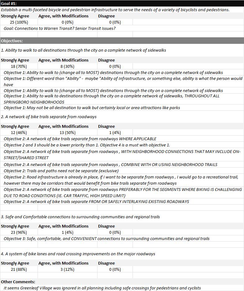
3 2
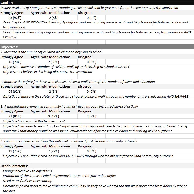
4 3
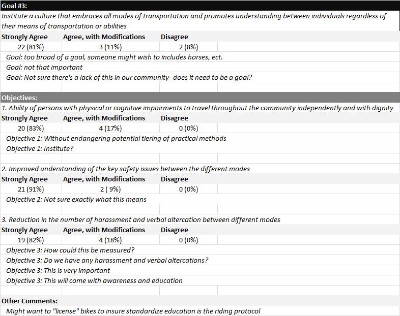
5 4

6 Priority Corridor s Evaluation Exercise Based on feedback from the web survey priority corridors were identified. Those corridors and are shown on the map below. 5

7 As a group, participants were asked to discuss the potential improvements for each of the corridors and then individually select the improvements that they would like to see along each corridor. The following matrix documents the number of votes for the desired facility improvement in each corridor There was a comment to add a shared lane marking to SR 741/S. Main Street in the Historic District and to Lower Springboro Road and W Mill Street west of SR 741. Overall, the majority of respondents would like to see sidewalks and bike lanes on many of these corridors with mid-block crossing improvements. A parallel neighborhood connector route was desired on SR 741 through downtown, Lytle-Five Points Road and W Mill St/Lower Springboro Road. 6

8 Neighborhood Connectors and Pathways Map Exercise As a group, participants were asked to think about the neighborhood connector routes and pathways that they currently use or would like to use to get to destinations in Springboro. Participants were asked to evaluate the provided potential routes, pathways and road crossings and note directly on the large map any changes or concerns they had with the routes. The following maps document the input. The following map identifies potential recommendations that the participants AGREED with. Agree With: 1. Like the proposed road crossing improvement at 741 and McCray needed (x 2) 2. Like the proposed sidewalks on Lytle-Five Points (x 2) 7
9 3. Like the potential pathway through the South Tech Business Park between Pennyroyal Road and Austin Road (x 2) 4. Like the proposed pathway at the northeast parcel of Clearcreek-Franklin Road at SR 73 (x 2) 5. Like to proposed path through Springboro Business Park connecting Clearcreek Park to Pioneer (x 2) 6. Like all the proposed road crossings on Lytle-Five Points (x 2) 7. Like the neighborhood connections on future roadways identified in Settlers Walk, maybe build temporary gravel paths here (x 2) 8. Like the conceptual pathway through Agricultural land south of Gardner Park (x 2) 9. Like the proposed bike route on East St in the Downtown 10. Like proposed sidewalk on north side of SR 73 between Clearcreek-Franklin Road and Springwood Dr 11. Like regional bike route on Lower Springboro Road to the East 12. The proposed bike lane on Yankee Rd would be helpful 13. Like the proposed road crossing improvement at 741 and Parker Drive 14. Like the proposed Bike Lane on Pennyroyal Road 15. Like the path along the Clear Creek under I-75 to the Great Miami River Trail 16. Like the potential pathway connection through the school campus connecting to the Heatherwoode Subdivision 8
10 The following map identifies potential recommendations that the participants DISAGREED with. Disagree With: 1. Do not like the regional bike route on Pennyroyal Road to the Great Miami River Trail, use Wood to Crain instead 2. Traffic does not warrant bike lane on Sharts Road or Pioneer Blvd 3. No not like the proposed bike lane and sidewalk on Shartz Rd 9
11 The following map identifies SUGGESTIONS from the participants. Suggestions: 1. Suggested connection trail connection between Victory Lane and W Factory (x 2) 2. Suggested pathway on Miamisburg Springboro Road to go all the way to Great Miami River Trail 3. Suggested trail along creek through E. Milo Beck Park connecting to the school campus 4. Suggested trail along the creek that runs north/south on the west side of Suggested off road trail through Sycamore Hills Country Club 6. Suggested crossing improvement at Factory Road and Myers Creek Lane 10
12 7. Suggested pathway between Westminster Way and Village Park Blvd to avoid Pennyroyal Road and to get to the parks 8. Suggested separated path between Factory Road and Clearcreek Park along the north side of Lower Springboro Road 9. Suggested path along the creek through the Heatherwoode Golf Course 10. Suggested path along the south boundary of town connecting schools to Red Lion-Five Points Road 11. Suggested bike path into E Milo Beck Park 12. Suggested connection between Clearsprings Drive and Stone Brook Ct 13. Suggested bike route on W Factory Rd 14. Suggested Bike Lane on Red-Lion Point Road from Lower Springboro to Reed Rd 11
13 The following map identifies OTHER COMMENTS from the participants. Other Comments: 1. At Village Park Shopping Center there is land for trails included in approved plat 2. There is a signal at northern entrance to the school campus 3. Need a way for neighborhoods on the Northeast side of town near Lytle-Five Points and Yankee Rd to get to the Marketplace and Downtown 4. Need signage along Lower Springboro Road to the East 5. Improve connections to Five Points Elementary 6. Prefer the neighborhood route on Westminster Way and Queensgate Road to Pennyroyal Road 7. Crains Run is not a bad road to ride on 8. Sidewalk does not exist on south side of Lytle-Five Points Road just to the west of Yankee Rd 12

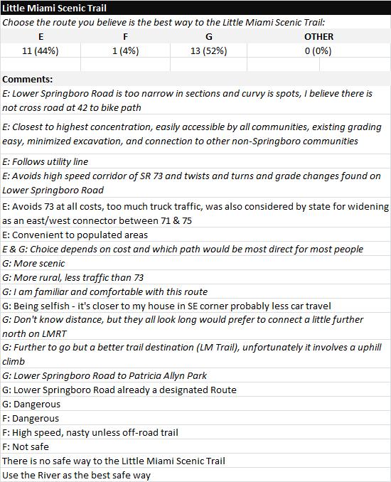
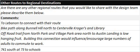
14 Regional Trail Connections Exercise The Regional Trail Connections Map displays some of the more obvious connection to the near-by regional trails. Participants were asked to determine which route they though was the most appropriate way to get to the near-by regional trails and identify some of the current issues with those routes. Regional Trail Connection Alternatives The responses are documented below. 13
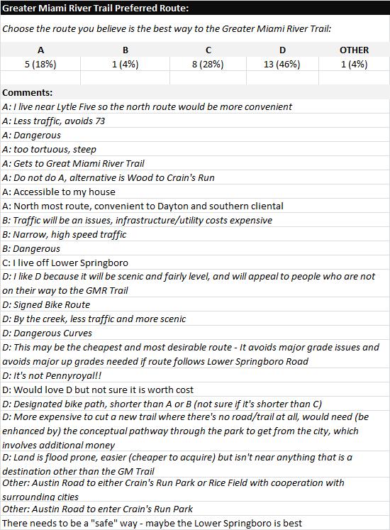
15 14
16 15
17 16

18 Comment Cards Participants were given the opportunity to share any additional information regarding the project on comment cards. The comments are posted below. 17
City Birmingham Multi-Modal Transportation Plan Visioning Workshop Results Meeting
 City Birmingham Multi-Modal Transportation Plan Visioning Workshop Results Meeting Monday, January 28, 2013 7:30 PM, City Hall Norman Cox, PLA, ASLA. Ann Arbor, Michigan. www.greenwaycollab.com Community
MASTER BICYCLE AND PEDESTRIAN PLAN
 VILLAGE OF NORTHBROOK MASTER BICYCLE AND PEDESTRIAN PLAN DRAFT PLAN OPEN HOUSE May 2, 2018 AGENDA 1. Community Engagement 2. Vision and Goals 3. General Structure of Plan 4. Recommendations Overview 5.
City of Birmingham Draft Multi-modal Transportation Plan
 City of Birmingham Draft Multi-modal Transportation Plan City Commission Public Hearing Monday, November 25, 2013 7:30 pm Norman Cox, PLA, ASLA The Greenway Collaborative, Inc. Ann Arbor, Michigan The
GIS Based Non-Motorized Transportation Planning APA Ohio Statewide Planning Conference. GIS Assisted Non-Motorized Transportation Planning
 The Purpose of GIS Assisted Network GIS Assisted Non-Motorized Transportation 2011 APA Ohio Statewide Conference Friday, 10:45 AM to Noon Focus on near-term projects wwwgreenwaycollabcom The purpose of
Bicycle and Pedestrian Facilities Toolbox (Excerpt from Figure 3.1)
") Appendix B Neighborhood Connections Summaries This Appendix is a supplement to the information presented in Chapter 3 Connect People. The Appendix includes a summary or profile for each of the proposed
Appendix B Neighborhood Connections Summaries This Appendix is a supplement to the information presented in Chapter 3 Connect People. The Appendix includes a summary or profile for each of the proposed
City of Novi Non-Motorized Master Plan 2011 Executive Summary
 City of Novi Non-Motorized Master Plan 2011 Executive Summary Prepared by: February 28, 2011 Why Plan? Encouraging healthy, active lifestyles through pathway and sidewalk connectivity has been a focus
KEARNY MESA COMMUNITY PLAN UPDATE
 KEARNY MESA COMMUNITY PLAN UPDATE January 18, 2018 SUBCOMMITTEE MEETING Mobility Concepts and Urban Design Presentation Outline Mobility Concepts: Multimodal Planning Toolbox Presentation and Activities
Elon Bicycle, Pedestrian and Lighting Plan. Pedestrian Rail Crossings Study
 Elon Bicycle, Pedestrian and Lighting Plan Pedestrian Rail Crossings Study Project Overview The Town of Elon, Elon University and the Twin Lakes Retirement Community began a comprehensive bicycle, pedestrian
TABLE OF CONTENTS. Executive Summary
 Executive Summary Background... ES-1 Pedestrian Network... ES-2 Bikeway Network... ES-2 Collision History... ES-2 Public Input... ES-4 Conclusions and Recommendations... ES-4 1. Introduction and Setting
Beach Cities Living Streets Design Manual and Aviation Boulevard Multimodal Corridor Plan
 Beach Cities Living Streets Design Manual and Aviation Boulevard Multimodal Corridor Plan AGENDA 1 Introductions & Project Scope 2 Public Outreach Recap 3 Living Streets Design Manual 4 Aviation Boulevard
CHAPTER 3: Vision Statement and Goals
 Davidson Walks & Rolls: Active Transportation Master Plan CHAPTER 3 Contents: Overview Vision Statement Measurable Goals Public Outreach CHAPTER 3: Vision Statement and Goals Overview The vision statement
East Burke Transportation, Safety and Capacity Improvements
 East Burke Transportation, Safety and Capacity Improvements The purpose of this project is to increase mobility and improve safety for pedestrians, cyclists, and motor vehicles along VT Route 114 in the
MAG Town of Cave Creek Bike Study Task 6 Executive Summary and Regional Significance Report
 Page 1 MAG Town of Cave Creek Bike Study Task 6 Executive Summary and Regional Significance Report August 1, 2012 MAG Project #481 Page 2 Task 6 Executive Summary and Regional Significance Report Introduction
COMMENT CARD SUMMARY
 NORTH PARK MID-CITY REGIONAL BIKE CORRIDORS PROJECT SAN DIEGO ASSOCIATION OF GOVERNMENTS COMMUNITY ADVISORY GROUP MEETING 1 January 30, 2013 6:00 p.m. 8:30 p.m. City Heights Wellness Center 4440 Wightman
TOWN OF WILLIAMSTON, SC BICYCLE AND PEDESTRIAN MASTER PLAN TOWN OF WILLIAMSTON, SC BICYCLE AND PEDESTRIAN MASTER PLAN
 TOWN OF WILLIAMSTON, SC BICYCLE AND PEDESTRIAN MASTER PLAN Americans Want Choices 55% of Americans would rather drive less & walk more. Transit use is growing faster than population or highway travel.
WalkShop. Highland Creek Village
 On June 5, 2014, 15 people participated in a for the Transportation Master Plan. The purpose of the was to receive feedback from a diverse range of local stakeholders and document existing transportation
Chapter 5 Future Transportation
 Chapter 5 Future Transportation The Future Land Use Plan identifies the desired land use designations. The land uses desired for Crozet depend, in large part, on the success of the transportation system,
Appendix A. Knoxville TPO Greenway Signage Guidelines. Appendix A: Knoxville TPO Greenway Signage Guidelines Knox to Oak Ridge Greenway Master Plan
 Appendix A Knoxville TPO Greenway Signage Guidelines 75 Overview: Adequate signing and marking are essential on shared-use paths, especially to alert bicyclists to potential conflicts and to convey regulatory
2014/2015 BIKE ROUTE PLAN 83 AVENUE PROTECTED BIKE LANE
 About the Project 2014/2015 BIKE ROUTE PLAN The City of Edmonton is planning a major bike route on the south side of Edmonton. This bike route is one part of a plan to provide citizens with transportation
El Paso County 2040 Major Transportation Corridors Plan
 El Paso County 2040 Major Transportation Corridors Plan Connect-our-County Online Transportation User Survey Preliminary Results June 24, 2010 Years of Residence 2. How many years have you LIVED HERE?
2016 Neighborhood Street Fund Application
 2016 Neighborhood Street Fund Application 2016-109 #146 COMPLETE Collector: Web Link 1 (Web Link) Started: Sunday, April 17, 2016 2:29:58 PM Last Modified: Sunday, April 17, 2016 2:36:28 PM Time Spent:
Austin Avenue Bridges Project. Public Meeting Summary
 Austin Avenue Bridges Project Public Meeting Summary June 29, 2016 Red Table Safety and Connectivity Notes: 1. Would like to see forensic report evaluations 2. What is the lifespan? 3. Extend safety considerations
2014/2015 BIKE ROUTE PLAN 83 AVENUE PROTECTED BIKE LANE
 About the Project The City of Edmonton is planning a major bike route on the southside of Edmonton. The Strathcona Bike Route will connect the communities of Strathcona, Garneau and the University area,
Chapter 13 ORANGE COVE
 Chapter 13 ORANGE COVE This chapter describes the current status and future plans for biking and walking in the City of Orange Cove. RELATIONSHIP TO CITY PLANS AND POLICIES The Orange Cove General Plan
Emergency Response Support Signage on Multi-Use Trails Plan
 DRAFT ( ) Emergency Response Support Signage on Multi-Use Trails Plan Prepared for: SATS Multi-Use Trails Jurisdictions Committee Table of Contents Introduction... 3 Mileage Markers... 4 Rest Stop Identifiers...
A Matter of Fairness: ROCOG s Environmental Justice Protocol. What is Mobility Limitation?
 No Person Left Behind What is Mobility Limitation? What is the Access Limitation? Environmental Justice population should be provided adequate mobility & access to meet their needs; Identify acceptable
Complete Streets for Eastham Prioritization Plan Eastham Library JUNE 13, 2018
 Complete Streets for Eastham Prioritization Plan Eastham Library JUNE 13, 2018 Bridge Street Bridge, Eastham What is a Complete Street? Complete Streets Defined: A Complete Street is one that provides
2.0 Existing Conditions
 20 2.0 Existing Conditions 2.1 Land Use, Future Growth Patterns, Physical Barriers Geographic Overview Sutter County s land use pattern is characterized by extensive agricultural areas, significant natural
Plant City Walk-Bike Plan
 Plant City Walk-Bike Plan Plant City Commute Mode Share 2.2% 1.4% 2.9% Drove alone 10.2% Carpooled Public transportation (0.1%) Walked Used a Bike (0.4%) 82.9% Taxicab, motorcycle, or other means Worked
Watertown Complete Streets Prioritization Plan. Public Meeting #1 December 14, 2017
 Watertown Complete Streets Prioritization Plan Public Meeting #1 December 14, 2017 Goals for Public Meeting Overview of MassDOT Complete Streets Funding Program Educate the community on Complete Streets
Safe Streets. City of Lake Forest Park. March 21, 2017
 Safe Streets City of Lake Forest Park March 21, 2017 1 01 WELCOME 2 Agenda WELCOME WHAT IS THIS PROJECT? CONTEXT DRAFT CITYWIDE PROJECTS EXERCISE INTRODUCTION 3 02 WHAT IS THIS PROJECT? 4 WHAT IS THIS
AGENDA REPORT. Issue: Discussion of potential improvements on Barnwell Road at Niblick Drive
 AGENDA REPORT To: From: By: Honorable Mayor and City Council Members Warren Hutmacher, City Manager Tom Black, Public Works Director Date: March 23, 2016 Agenda: March 28, 2016 WORK SESSION AGENDA: Barnwell
PRIORITIES RESULTS YOUR PRIORITIES FOR BRIDGEPORT 5% 4% 13% RESIDENTIAL CHOICES TRAILS & PARKS
 Community Visioning Open House The Community Visioning Open House was held on January, 31st 2018 at Harrisburg Area Community College (HACC), Lancaster Campus. Approximately 80 people attended this Open
Montford Drive Parking & Circulation Study
 Montford Drive Parking & Circulation Study Parking & Circulation Study Follow up to the Area Plan based on what we heard Purpose 1 2 3 4 To look closer and evaluate parking and network related issues (including
WELCOME. Stakeholder Involvement Group Meeting #2 Round Lake Public Works October 24, 2018
 WELCOME Stakeholder Involvement Group Meeting #2 Round Lake Public Works October 24, 2018 MEETING AGENDA 1. Welcome and Introductions 2. Study Progress Update 3. Problem Statement 4. Technical Analysis
Tuesday, September 25 th Mount Holly Municipal Complex 400 East Central Avenue 5:30pm to 7:30pm. Activity Stations o Where do you Live?
 Meeting Information Overview The public workshop for the Mount Holly Comprehensive Bicycle Plan occurred on September 25, 2018. The drop-in workshop allowed attendees to participate in a series of interactive
Thank you for attending
 Improving mobility safety comfort WELCOME Thank you for attending The purpose of this meeting is to: Learn about the project Prioritize potential walking and biking improvements on Snelling Ave Gather
City of Charlottesville Bicycle and Pedestrian Master Plan Update
 City of Charlottesville Bicycle and Pedestrian Master Plan Update September 17, 2014 I. Welcome and meeting overview II. Project status update III. Network overview IV. Break-out groups Pedestrian Network
RiNo Railroad Crossing Connectivity Analysis. Stakeholder Workshop June 29, 2017
 RiNo Railroad Crossing Connectivity Analysis Stakeholder Workshop June 29, 2017 Ideas and Considerations Presented at Stakeholder Workshop Primary Focus: 38 th Street (between Walnut & Wynkoop) 1 Basic
University of Victoria Campus Cycling Plan Terms of Reference. 1.0 Project Description
 University of Victoria Campus Cycling Plan Terms of Reference 1.0 Project Description The Campus Cycling Plan, a first for the University, will provide a comprehensive and coordinated approach to support
SR-203 Sidewalks and Town-Wide Mobility Improvements. Town Council Presentation September 7, 2016
 SR-203 Sidewalks and Town-Wide Mobility Improvements Town Council Presentation September 7, 2016 SR-203 Sidewalks and Town- Wide Mobility Improvements SR-203 Sidewalks and Appurtenances Town-Wide Mobility
GIS Based Data Collection / Network Planning On a City Scale. Healthy Communities Active Transportation Workshop, Cleveland, Ohio May 10, 2011
 The Purpose of GIS Based Network Planning GIS Based Data Collection / Network Planning Healthy Communities Active Transportation Conference Tuesday, May 10, 2011 10:00 AM Norman Cox, LLA, ASLA. Ann Arbor,
Hamilton Transportation Master Plan Public Consultation. Public Information Centre One Summary
 Hamilton Transportation Master Plan Public Consultation Public Information Centre One Summary Table of Contents Introduction 1 Purpose 2 What Was Presented 2 Who Came to the Meeting 2 The Breakout Sessions
The Leadville Bikeway Design Recommendations DRAFT January 2018
 The Leadville Bikeway Design Recommendations DRAFT January 2018 Overview The Leadville Bikeway project aims to create a bikeway that is compatible with and adds value to the neighborhood and surrounding
10A. DATE: October 5, Pedestrian and Bicycle Advisory Committee. Kevin Colin, Deputy Planning Manager Curt Bates, City Engineer
 10A DATE: October 5, 2016 TO: PREPARED BY: SUBJECT: Pedestrian and Bicycle Advisory Committee Kevin Colin, Deputy Planning Manager Curt Bates, City Engineer Discussion and Provide Comments, Associated
Lake to Lake LAKE YORK. CYCLING ROUTE and WALKING TRAIL FEASIBILITY and DESIGN STUDY LAKE. CITY of REGION ONTARIO SIMCOE TORONTO
 LAKE SIMCOE Lake to Lake CYCLING ROUTE and WALKING TRAIL FEASIBILITY and DESIGN STUDY YORK REGION Overview Report JUNE 2013 CITY of TORONTO LAKE ONTARIO Table of Contents Study background 2 Study Background............................
Bicycle-Pedestrian Master Plan: Chapters 3 and 4 Distribution
 Bicycle-Pedestrian Master Plan: Chapters 3 and 4 Distribution Finksburg Planning and Citizens Council March 22, 2018 Overview Progress Citizen Outreach Vision Chapter 3 - Existing Conditions Chapter 4
Urbana Pedestrian Master Plan
 Urbana Pedestrian Master Plan Recommendations Gabe Lewis, Transportation Planner Champaign County Regional Planning Commission November 15, 2018 Public Meeting #2 Public Input Round #1 Thank You! 10 public
TRANSPORTATION COMMISSION Agenda Staff Report
 TRANSPORTATION COMMISSION Agenda Staff Report Agenda Item No. 5.a DATE: JULY 31, 2014 TO: FROM: SUBJECT: TRANSPORTATION COMMISSION COMMUNITY DEVELOPMENT DEPARTMENT - PLANNING DRAFT OLYMPIC CORRIDOR PREFERRED
Make Lincoln Highway an economically vibrant corridor that is safe, efficient, and beautiful for local residents and visitors.
 Lincoln Highway Streetscape Plan Stakeholder Workshop #2 Handout Contents Introduction and Project Vision Planning Principles Specific Recommendations including a Proposed Typical Roadway Section Renderings
50 Avenue S.W. Corridor Study Glenmore Aquatic Centre Drop-In Event
 Project overview The City of Calgary is conducting a transportation corridor study of 5 Avenue S.W., between Crowchild Trail and 4A Street S.W. In 29, it was reclassified as a Parkway under the Calgary
What are the Qualities that make Newark a Bicycle Friendly Community? What are aspects that make Newark less Bicycle Friendly?
 What are the Qualities that make Newark a Bicycle Friendly Community? Many stores are within biking distance (1) Lots of bike lanes and new trail Existing bike routes (2) Designated bike lanes on Del ave.
Board of Supervisors February 27, 2017
 : Traffic Analysis Results & Draft Conceptual Plan Board of Supervisors February 27, 2017 Transportation Solutions Building Better Communities Presentation Overview Background Summary of Traffic Analysis
West Dimond Blvd Upgrade Jodhpur Street to Sand Lake Road
 West Dimond Blvd Jodhpur St to Sand Lake CSS Transportation Project Summary Municipality of Anchorage Project # 05 005 Project Manager: John Smith, P.E. (MOA PM&E) Project Administrator: Julie Makela,
Regional Trails Corridor Assessment
 Regional Trails Corridor Assessment Project Goals Complete the regional trails network in the River to Sea TPO Planning Area and advance the Florida Greenways and Trails System Plan by developing/finalizing
MASTER BICYCLE AND PEDESTRIAN PLAN
 WELCOME! PLEASE FEEL FREE TO REVIEW THE EXHIBITS THE PRESENTATION WILL BEGIN AT 6:00 PM VILLAGE OF NORTHBROOK MASTER BICYCLE AND PEDESTRIAN PLAN DRAFT EXISTING CONDITIONS REPORT AND PUBLIC MEETING WELCOME!
Getting Your SRTS Project Funded. Ryan Snyder
 Getting Your SRTS Project Funded Ryan Snyder Steps in Submitting a Successful Application 1. Stakeholder outreach: create a SRTS coalition 2. Develop a comprehensive plan and program with all 5 Es 3. Conceive
Best Southwest Transportation Committee. North Central Texas Council of Governments Transportation Department
 Best Southwest Transportation Committee North Central Texas Council of Governments Transportation Department The The Regional Regional Veloweb Veloweb Review Review NCTCOG Bicycle and Pedestrian Program
STONY PLAIN ROAD STREETSCAPE
 Jasper Place Revitalization Strategy: Vision The people involved in the Jasper Place Revitalization Strategy envision: Goal 1: Feeling safe in our community Create a community where feeling safe is common--where
HARRISON STREET/OAKLAND AVENUE COMMUNITY TRANSPORTATION PLAN
 HARRISON STREET/OAKLAND AVENUE Community Workshop #4: Draft Plan Review December 3, 2009 D E S I G N, C O M M U N I T Y & E N V I R O N M E N T INTRODUCTIONS Key Project Staff: Alisa Shen, Project Manager,
CITY OF ELKO BICYCLE AND PATHWAY PLAN
 CITY OF ELKO BICYCLE AND PATHWAY PLAN INTRODUCTION: The City of Elko is intended to provide the basic framework for the development of a functional bicycle and pathway system for the community with connections
CONNECTING PEOPLE TO PLACES
 CONNECTING PEOPLE TO PLACES 82 EAST BENCH MASTER PLAN 07 Introduction The East Bench transportation system is a collection of slow moving, treelined residential streets and major arteries that are the
Hennepin County Bicycle and Pedestrian Planning
 Hennepin County Bicycle and Pedestrian Planning 1 Value of bicycle and sidewalk systems Safety Livability Mobility Health Personal Finances Economic Sustainability Clean Air Recreation Parking and congestion
Public Workshop #2. September 14, 2016
 Public Workshop #2 September 14, 2016 Agenda Welcome Project Overview Where We Have Been Alternatives for State Street Land Use Street Design Next Steps 2 Project Overview Create a Vibrant State Street
Sandwich Pedestrian/Bicycle Planning
 Sandwich Pedestrian/Bicycle Planning Improved Pedestrian and Bicycle Connections with the Cape Cod Canal Multi-use Path February 2014 Table of Contents Introduction... 1 Background... 1 Study Goals...
Bar Harbor Route 3 Gateway Project Advisory Committee September 21, 1-3 PM Atlantic Oakes Hotel Minutes
 Bar Harbor Route 3 Gateway Project Advisory Committee September 21, 1-3 PM Atlantic Oakes Hotel Minutes Attending: Dick Cough, Edith Milbury, James Blanchard, Chris Fogg, Paul MacQuinn Millard Billings,
Monroe Street Reconstruction Business Focus Group Notes July 18, 2016, HotelRED
 Monroe Street Reconstruction Business Focus Group Notes July 18, 2016, HotelRED Total participants: 31 Focus Group Conversation #1: During this exercise, participants talked in small table groups in response
Lee s Summit Road Improvement Study Public Open House June 7, 2007 Summary of Comment Card Responses
 Lee s Summit Road Improvement Study Public Open House June 7, 2007 Summary of Comment Card Responses Introduction At the Lee s Summit Road Improvement Study Public Open House held Thursday, June 7, 2007
Eliminate on-street parking where it will allow for a dedicated bus only lane %
 Traffic Dashboard Priorities Survey Responses Introduction 1) Are you familiar with bus rapid transit (BRT)? a. No, BRT is new to me. 597 23.5% b. I ve heard of BRT, but I don t know much about it. 1,136
Corpus Christi Metropolitan Transportation Plan Fiscal Year Introduction:
 Introduction: The Safe, Accountable, Flexible, Efficient Transportation Equity Act: A Legacy for Users (SAFETEA-LU) has continued the efforts started through the Intermodal Surface Transportation Efficiency
Construction Specifications Manual
 Isle of Wight County Pedestrian and Bicycle Master Plan Construction Specifications Manual Adopted August 20, 2009 Introduction The Isle of Wight County Pedestrian and Bicycle Facilities Master Plan was
Fairview and Main Local Streets Improvement Plan
 PIM#2 Summary Report Meeting Format Date & Time: Location: Address: Prepared By: Community Open House August 11, 2016 5:30 p.m. 7:30 p.m. Red Lion Hotel 1800 W. Fairview Avenue, Boise Stephanie Borders,
Franklin Boulevard Traffic Calming Study. Public Meeting #1 October 11, 2017
 Franklin Boulevard Traffic Calming Study Public Meeting #1 October 11, 2017 Agenda Welcome and Introductions Project Overview Potential Improvements Map Exercise Report Out NOACA Technical Assistance (TA)
Commerce Street Complete Street Project from Good Latimer Expressway to Exposition Avenue
 Commerce Street Complete Street Project from Good Latimer Expressway to Exposition Avenue T A N Y A B R O O K S A S S I S T A N T D I R E C T O R M O B I L I T Y P L A N N I N G M O B I L I T Y A N D S
Overview: Phase 3 Draft Development and Circulation Plans, White Bear Station
 Overview: Phase 3 Draft Development and Circulation Plans, White Bear Station This overview explains how to get more involved and provides information on the Phase 3 draft circulation and development plans
Ulster County Non-motorized Transportation Plan
 Ulster County Non-motorized Transportation Plan NTAC Meeting NOTES Ulster County Community College Date 08.29.07 Time: 1:00 p.m. - 3:00 p.m. Agenda Welcome /Intro Project Status Report o Project is on
Public Feedback Comments Appendix G. Appendix G. Public Feedback Comments. Virginia Beach Bikeways and Trails Plan 2011 Page G-1
 Public Feedback Comments Virginia Beach Bikeways and Trails Plan 2011 Page G-1 This is a complete collection to date of responses to the feedback survey which was used at public open houses in December
Laurier Segregated Bike Lane Pilot Project July 2013 update
 Laurier Segregated Bike Lane Pilot Project July 2013 update Presentation Overview Background Pilot Monitoring Results Mitigation Recommendations Next Steps Laurier 2 Background Laurier Avenue Segregated
Feasibility Study. Expo-Downtown Bicycle Connector
 Feasibility Study Expo-Downtown Bicycle Connector May 2017 Table of Contents Introduction... 2 Project Goals... 2 Study Scope... 2 Community Engagement... 3 Project Description... 6 Considerations... 6
US 41 COMPLETE STREETS CORRIDOR PLANNING STUDY from University Parkway to Whitfield Avenue
 41 US 41 COMPLETE STREETS CORRIDOR PLANNING STUDY from University Parkway to Whitfield Avenue EXECUTIVE SUMMARY DRAFT FEBRUARY 2019 Project Overview The US 41 Complete Streets Corridor Planning Study,
Downtown Naples Mobility and Connectivity Study. Naples City Council Presentation January 2017
 Downtown Naples Mobility and Connectivity Study Naples City Council Presentation January 2017 Agenda 1. Introduction 2. Scope Review 3. Project Schedule 4. Existing Conditions 5. Public Charrette 6. Mobility
Proposed Bridge Street East Bicycle Lanes Public Open House Thursday, April 27, 2017
 WELCOME Proposed Bridge Street East Bicycle Lanes Public Open House Thursday, April 27, 2017 Purpose of the Open House The purpose of this Open House is to gain public input on the bicycle lanes proposed
TRAFFIC IMPACT STUDY CRITERIA
 Chapter 6 - TRAFFIC IMPACT STUDY CRITERIA 6.1 GENERAL PROVISIONS 6.1.1. Purpose: The purpose of this document is to outline a standard format for preparing a traffic impact study in the City of Steamboat
SAFE ROUTES TO SCHOOL (SR2S)
") SAFE ROUTES TO SCHOOL (SR2S) In partnership with Burbank Unified School District (BUSD) & City of Burbank George Washington Elementary School Thomas Jefferson Elementary School John Muir Middle School
SAFE ROUTES TO SCHOOL (SR2S) In partnership with Burbank Unified School District (BUSD) & City of Burbank George Washington Elementary School Thomas Jefferson Elementary School John Muir Middle School
A Plan for The Beautiful Way NOVEMBER 16, 2009
 COMMUNITY VISION WORKSHOP NOVEMBER 16, 2009 AGENDA INTRODUCTION COMMUNITY INPUT REVIEW AND SURVEY RESULTS VISIONING IMAGERY SMALL GROUP VISIONING SESSION NEXT STEPS CLOSE SCHEDULE COMMUNITY SURVEY 198
Table #6 VISION CHARACTERISTICS
 Table #6 VISION White Flint is a place to live, work, play, shop, and walk with sufficient density to encourage quality redevelopment. Vibrant streets and consistent streetscapes are important. CHARACTERISTICS
PRINCE GEORGE S PLAZA METRO AREA PEDESTRIAN PLAN
 PRINCE GEORGE S PLAZA METRO AREA PEDESTRIAN PLAN May 28, 2008 Agenda Welcome and introductions Project overview and issue identification Planning context and strengths Design challenges and initial recommendations
City of Davis East Covell Corridor Plan
 Community Open House #2 January 22, 2014 6:00 8:00 p.m. Veterans Memorial Center, Club Room City of Davis Introduction The (ECCP) is a taking a comprehensive look at the existing transportation systems
Prince George s County plans, policies, and projects
 Prince George s County plans, policies, and projects Over 250 projects for trails, bikeways, designated bike lanes and sidewalk construction Trail projects that improve access to Metro Sidewalk and trail
BIKE PLAN CONTENTS GATEWAY
 CONTENTS Acknowledgments...vii Great Rivers Greenway District Board of Directors... vii Great Rivers Greenway District Staff... vii Project Consultants... vii Committees... viii Citizens Advisory Committee
Community Task Force March 14, 2018
 Community Task Force March 14, 2018 Welcome and Introductions Project Partners Regional Transportation District (RTD) City of Aurora Colorado Department of Transportation (CDOT) Denver Regional Council
EXECUTIVE SUMMARY... vii 1 STUDY OVERVIEW Study Scope Study Area Study Objectives
 Contents EXECUTIVE SUMMARY... vii 1 STUDY OVERVIEW... 1-1 1.1 Study Scope... 1-1 1.2 Study Area... 1-1 1.3 Study Objectives... 1-3 2 EXISTING CONDITIONS... 2-1 2.1 Existing Freeway Conditions... 2-4 2.1.1
Executive Summary Route 30 Corridor Master Plan
 Route Corridor Master Plan Project Overview The Route Corridor Master Plan is a coordinated multimodal transportation and land use plan for the entire stretch of Route through East Whiteland Township,
S A F E R O U T E S T O S C H O O L H E R M A N TOW N S C H O O L S A N D P R O C TO R S C H O O L S P L A N A P P R OVA L S
 S A F E R O U T E S T O S C H O O L H E R M A N TOW N S C H O O L S A N D P R O C TO R S C H O O L S P L A N A P P R OVA L S WHAT IS SAFE ROUTES TO SCHOOL? In 1969, nearly 50% of children walked or rode
Portland International Airport Bicycle and Pedestrian Plan (October 2003) Staff Acknowledgements
 Staff Acknowledgements") Portland International Airport Bicycle and Pedestrian Plan (October 2003) Staff Acknowledgements Scott King, Senior Aviation Planner Jason Gately, Senior Aviation Planner Preston Beck, Associate Planner
Portland International Airport Bicycle and Pedestrian Plan (October 2003) Staff Acknowledgements Scott King, Senior Aviation Planner Jason Gately, Senior Aviation Planner Preston Beck, Associate Planner
MONTGOMERY COUNTY COUNCIL MEMORANDUM
 MONTGOMERY COUNTY COUNCIL R O C K V I L L E, M A R Y L A N D HANS RIEMER COUNCILMEMBER AT-LARGE MEMORANDUM To: T&E Committee From: Councilmember Hans Riemer Date: March 1, 2016 Re: Funding a Protected
SAFE ROUTES TO SCHOOL
 SAFE ROUTES TO SCHOOL Forest Ridge Elementary School Existing Conditions and ACTION PLAN > Oak Creek - Franklin Joint School District Table of Contents CONTEXT Enrollment Boundaries
Meade Street Bridge Design Alternative Study
 Meade Street Bridge Design Alternative Study Preferred Alternative Presentation Stakeholder Meeting #3 June 23, 2011 Presented by: Dan Biggs, RLA Meeting Agenda Purpose: 1. Review Meeting #2 Feedback 2.
School Travel Survey for District Superintendents/Board Chairs
 School Travel Survey for District Superintendents/Board Chairs 1. How do most of the elementary and middle school students in your district get to school in the morning? (Please select only one box) by
Northside Livable Centers Study
 Northside Livable Centers Study Advisory Committee Meeting #2 Preferred Conceptual Plan March 2, 2010 AGENDA FOR ADVISORY COMMUNITY WORKSHOP #1 Project Overview and Timeline Planning Area Overview Workshop