Regional Trails Corridor Assessment
|
|
|
- Godfrey Preston
- 5 years ago
- Views:
Transcription

1 Regional Trails Corridor Assessment

2 Project Goals Complete the regional trails network in the River to Sea TPO Planning Area and advance the Florida Greenways and Trails System Plan by developing/finalizing alignments and connections Understand/inventory where there are existing trail gaps and determine the feasibility of alignments Complete assessments and develop conceptual plans and cost estimates for all gap segments in order to compete for funding

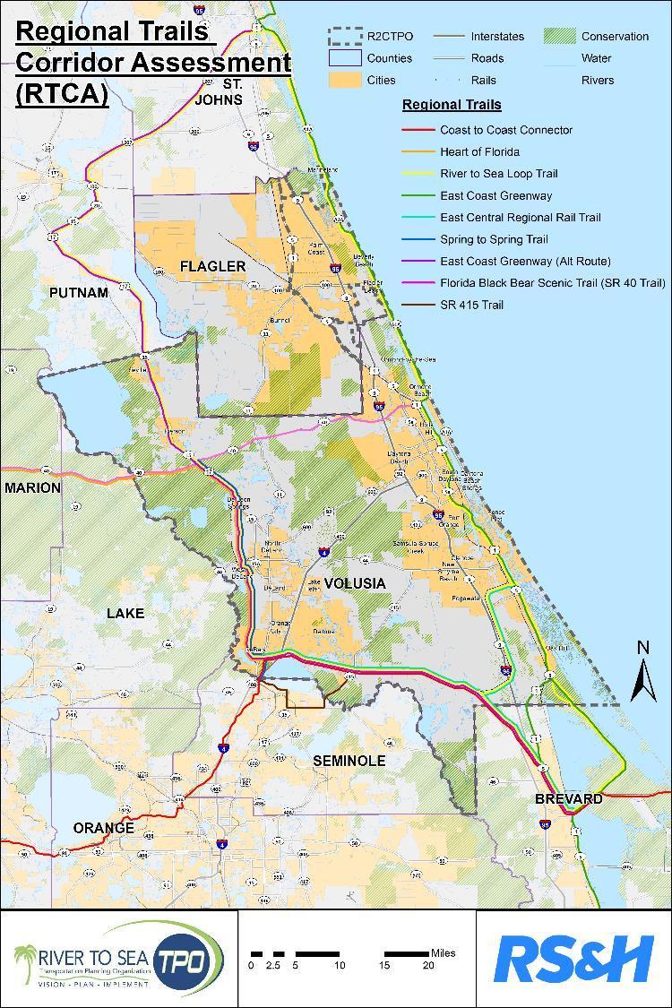
3 Regional Trails for RTCA
4 Regional Trail Widths Guidelines FDOT Plans Preparation Manual, 2012 (Design Guidance for Shared Use Paths) Widths Excerpts from National and State Trail Guidelines and Manuals FDOT Manual on Uniform Traffic Control Devices (MUTCD) (known as the Florida Greenbook) 2011 (Shared Use Path) FHWA, Manual on Uniform Traffic Control Devices Source: Best Practices Design Guide American Association of State Highway and Transportation Officials (AASHTO), Guide for the Development of Bicycle Facilities, th edition (Shared Use Paths) Typically, widths range from feet The minimum width for a twodirectional shared use path is 10 feet. The minimum recommended width for a paved two-way path is 10 feet. In many cases, it is desirable to increase the minimum width to 12 feet. In limited cases, 8 feet may be acceptable. The tread of a shared-use path should be at least 10 ft. wide. A minimum of 8 ft may be used on shareduse paths that will have limited use. On shared-use paths with heavy volumes of users, tread width should be increased to a range from 12 to 14 ft. The minimum paved width for a two-directional shared use path is 10 ft Typically, widths range from 10 to 14 ft. A path width of 8 ft may be used for a short distance Eleven (11) foot pathways are needed to enable a bicyclist to pass another path user going the same direction.
5 Project Methodology Overview Data Collection Stakeholder Meeting #1 Small Group Workshops Field Reviews Stakeholder Meeting #2 Concept / Cost Development and Documentation
6 Project Milestones September 29, 2014 Introduced Study and Obtained Input 23 Participants November 19-20, 2014 Eight (8) field review meetings Visited Potential Trail Gap Locations March 2015 Final Report/ GIS Map Completed Data Collection Stakeholder Meeting #1 Small Group Workshops Field Reviews Stakeholder Meeting #2 Concept / Cost Development and Documentation Aug-Nov 2014 October 29-30, 2014 Detailed Review of Trail Segments Four (4) Interactive Workshops December 17, 2014 Presented Draft Study Findings 26 Participants April 2015 Final Report Adopted by River to Sea TPO


7 Inventory of Regional Trails Existing Trails Planned / Programmed Trails Gaps and Proposed Alignments

8 Existing Regional Trails


9 Planned/Programmed Trails Work Programs TIP State and Local Projects Studies


10 Gaps and Proposed Alignments Resolutions Master Plans Regional Corridor Alignments Field Review Stakeholder Input

11 Connectors / Potential Trails of Regional Significance Connector Trails Existing Connectors Existing Connector Recommended Connectors Recommended by Stakeholders Trail Recommended by Stakeholders Multi-use Path / Sidewalk

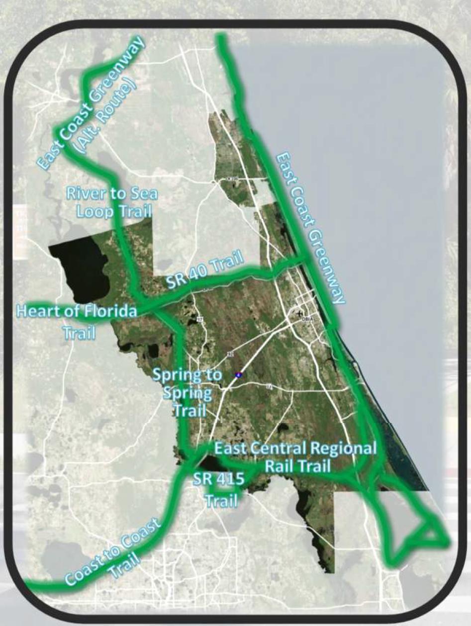
12 RCTA Inventory Results
13 Trail Gap Matrix (1 of 2) Trail Gap Segment ID A B C D E F Jurisdiction City of Flagler Beach City of Ormond Beach City of Daytona Beach City of South Daytona City of Edgewater Volusia County (West of DeLand) Road Name(s) Regional Trail(s) Segment Start Segment End Length (miles) A1A ECG, R2C N. 9 th Street S 26 th Street 2.9 A1A ECG, R2C Standish Drive Beach Street Carmen Drive and Reed Canal Road W. Park Ave, Mango Tree Dr., 16 th St., Hibiscus Dr., Roberts Road W. Minnesota Ave, S. Grand Ave, S. Beresford ECG, R2C ECG, R2C ECG, R2C S2S, R2C, ECG-A, HoF Marina Point Drive Ridge Boulevard at Carmen Drive East Central Regional Rail Trail (ECRRT) terminus at Dale Street W. Beresford Rd to terminus of Alexander Dr. East Grenada Boulevard Bellevue Avenue Reed Canal Road at US Roberts Road 4.5 Beresford Park 2.9 Recommended Next Steps Conduct feasibility study subsequent to completion of City s parking study Conduct feasibility study for bike lanes along Halifax Drive and Standish Drive Complete concept design for gap Complete concept design for gap Complete feasibility study of southbound ECCRT connection through Edgewater Complete concept design for gap * ECG = East Coast Greenway (and Alternate); R2C = River To Sea; HoF = Heart of Florida; S2S = Spring to Spring; ECRRT = East Central Regional Rail Trail
14 Trail Gap Matrix (2 of 2) Trail Gap Segment ID G H Jurisdiction Volusia County (West of DeLand) Volusia County (DeLeon Springs) Road Name(s) Grand Avenue US 17 / Baxter Street Regional Trail(s) S2S, R2C, ECG-A, HoF S2S, R2C, ECG-A, HoF Segment Start Segment End Length (miles) Lemon Street King Street 1.7 McGinnis Elementary School I Volusia County SR 17 R2C, ECG-A SR 40 J Volusia County (West of Ormond Beach) SR 40 Florida Black Bear Scenic Trail Baxter Street at Grand Avenue Putnam County Line Cone Road Airport Road 2.2 Recommended Next Steps Subsequent to County s construction of five foot bike lanes and five foot sidewalks in both directions, continue to monitor community support for potential construction of a regional trail with a standard width Complete feasibility study for crossings at Baxter Street and US 17 and trail connecting from McGinnis Elementary School to Grand Ave Complete concept design for gap Complete concept design for gap * ECG = East Coast Greenway (and Alternate); R2C = River To Sea; HoF = Heart of Florida; S2S = Spring to Spring; ECRRT = East Central Regional Rail Trail


15 Project Deliverables GIS / KMZ files General Concept Plans and Cost Estimates for Trail Gaps Final Report Study Area Overview Statewide and Local Guidance Methodology Trail Gaps and Recommendations Identification of Challenges and Opportunities

16 Post RTCA Developments 2015: SUN Trail Network created by the Florida Legislature 2016: St. Johns River to Sea Loop Trail designated as the #1 regional trail system in Florida
17 Project Contact Stephan C. Harris Transportation Planner-Project Manager Phone: , extension Thank you for your time.
2016 TELL THE TPO SURVEY
 RIVER TO SEA TRANSPORTATION PLANNING ORGANIZATION 2016 TELL THE TPO SURVEY CAMPAIGN SUMMARY August 2016 Introduction The River to Sea Transportation Planning Organization (TPO) conducted its second Tell
PROJECT OVERVIEW & WORK COMPLETED
 CR/SR A1A PEDESTRIAN SAFETY & MOBILITY STUDY RIVER TO SEA TRANSPORTATION PLANNING ORGANIZATION TPO Board Meeting April 27, 2016 PROJECT OVERVIEW & WORK COMPLETED 1 Project Overview Study Limits Bethune
Florida Department of Transportation District Four. I-95 at 6 th Avenue Interchange Improvements FDOT PM - Fernando Morales, PE
 1 Florida Department of Transportation District Four I-95 at 6 th Avenue Interchange Improvements FDOT PM - Fernando Morales, PE Presentation Outline Overview of Planning and Programming I-95 Interchange
Amelia Island Trails (AIT) Progress and Proposed 5-YR Plan JANUARY 16, 2018
 Progress and Proposed 5-YR Plan JANUARY 16, 2018") Amelia Island Trails (AIT) Progress and Proposed 5-YR Plan JANUARY 16, 2018 PHIL SCANLAN FRIENDS OF AIT, INC. CEO WHY AM I HERE? 1. We have made good progress on A.I. Trails. 2. We CAN T meet our Goal
Amelia Island Trails (AIT) Progress and Proposed 5-YR Plan JANUARY 16, 2018 PHIL SCANLAN FRIENDS OF AIT, INC. CEO WHY AM I HERE? 1. We have made good progress on A.I. Trails. 2. We CAN T meet our Goal
CITY OF COCOA BEACH 2025 COMPREHENSIVE PLAN. Section VIII Mobility Element Goals, Objectives, and Policies
 CITY OF COCOA BEACH 2025 COMPREHENSIVE PLAN Section VIII Mobility Element Goals, Objectives, and Policies Adopted August 6, 2015 by Ordinance No. 1591 VIII MOBILITY ELEMENT Table of Contents Page Number
LANE ELIMINATION PROJECTS
 PRESENTATION OUTLINE Lane Elimination Considerations Districts 4 & 7 Draft Lane Elimination Processes FDOT Lane Elimination Guidelines Example Projects D4 Case Study: SR A1A (Ft. Lauderdale) D7 Case Study:
Presentation Outline. PD&E Study Process Project Overview Proposed Alternatives & Evaluation Schedule Contact Information
 Volusia Transportation Planning Organization CAC / TCC Project Update Tuesday, May 21, 2013 1 Presentation Outline PD&E Study Process Project Overview Proposed Alternatives & Evaluation Schedule Contact
State Bicycle and Pedestrian Advisory Committee Meeting. March 27, 2013 John Bolecek Statewide Bicycle and Pedestrian Planner
 State Bicycle and Pedestrian Advisory Committee Meeting March 27, 2013 John Bolecek Statewide Bicycle and Pedestrian Planner BPAC Meeting Agenda 1. Welcome and Introductions 2. Committee Structure 3. Status
APPENDIX A: Complete Streets Checklist DRAFT NOVEMBER 2016
 APPENDIX A: Complete Streets Checklist DRAFT NOVEMBER 2016 Complete Streets Checklist MetroPlan Orlando s Complete Streets Checklist is an internal planning tool for staff to further implementation of
Board of Supervisors February 27, 2017
 : Traffic Analysis Results & Draft Conceptual Plan Board of Supervisors February 27, 2017 Transportation Solutions Building Better Communities Presentation Overview Background Summary of Traffic Analysis
Emergency Response Support Signage on Multi-Use Trails Plan
 DRAFT ( ) Emergency Response Support Signage on Multi-Use Trails Plan Prepared for: SATS Multi-Use Trails Jurisdictions Committee Table of Contents Introduction... 3 Mileage Markers... 4 Rest Stop Identifiers...
SR 693 (Pasadena Avenue) Corridor Study from Shore Drive South to 66 th Street
 Corridor Study from Shore Drive South to 66 th Street") Welcome and Introduction Sign-in and comment sheets Restrooms and exits Meeting agenda and timeline Meeting goals / expectations Provide input to guide study recommendations Actively participate throughout
Welcome and Introduction Sign-in and comment sheets Restrooms and exits Meeting agenda and timeline Meeting goals / expectations Provide input to guide study recommendations Actively participate throughout
SR/CR A1A PEDESTRIAN SAFETY & MOBILITY STUDY RIVER TO SEA TRANSPORTATION PLANNING ORGANIZATION
 SR/CR A1A PEDESTRIAN SAFETY & MOBILITY STUDY RIVER TO SEA TRANSPORTATION PLANNING ORGANIZATION 2016 Florida Section ITE Annual Summer Meeting June 24, 2016 Today s Presenters Lois Bollenback Executive
City of Richmond Bicycle Master Plan
 City of Richmond Bicycle Master Plan October 2011 Prepared by Fehr & Peers In association with Eisen Letunic City of Richmond Bicycle Master Plan October 2011 Prepared by Fehr & Peers In association with
Stakeholder Update. Agenda. Project update Needs Identification Strategy Proposed needs Safety Collectors/Arterials Greenways Local roads
 1 Stakeholder Update May 21, 2018 2 Agenda Project update Needs Identification Strategy Proposed needs Safety Collectors/Arterials Greenways Local roads Proposed Evaluation Criteria Next Steps 1 Project/Schedule
St. Johns River-to-Sea Loop. St Johns River-to-Sea Loop Alliance SJR2C.Org
 St. Johns River-to-Sea Loop St Johns River-to-Sea Loop Alliance SJR2C.Org About the SJR2C - The Loop 270 mile multi-use trail Biking Walking Running Outer Corners St. Augustine Debary Titusville Palatka
Construction Specifications Manual
 Isle of Wight County Pedestrian and Bicycle Master Plan Construction Specifications Manual Adopted August 20, 2009 Introduction The Isle of Wight County Pedestrian and Bicycle Facilities Master Plan was
TABLE OF CONTENTS. Executive Summary
 Executive Summary Background... ES-1 Pedestrian Network... ES-2 Bikeway Network... ES-2 Collision History... ES-2 Public Input... ES-4 Conclusions and Recommendations... ES-4 1. Introduction and Setting
MAKE YOUR PLACE IN CHANNELSIDE
 MAKE YOUR PLACE IN CHANNELSIDE INTRODUCTION PROJECT LIMITS Channelside Drive from Cumberland Ave to Kennedy Boulevard EXISTING CONDITIONS EXISTING CONDITIONS CHANNELSIDE DRIVE FROM E. CUMBERLAND AVENUE
Final Sidewalk Feasibility Study
 Garfield Drive From Anastasia Drive to Elizabeth Place City of South Daytona July 23, 2009 Final Sidewalk Feasibility Study Prepared for: Prepared by: Final Sidewalk Feasibility Study Garfield Drive 2
BIKE PLAN CONTENTS GATEWAY
 CONTENTS Acknowledgments...vii Great Rivers Greenway District Board of Directors... vii Great Rivers Greenway District Staff... vii Project Consultants... vii Committees... viii Citizens Advisory Committee
Appendix C. Bicycle Route Signage
 Appendix C Bicycle Route Signage This page intentionally left blank. APPENDIX C - BICYCLE ROUTE AND WAYFINDING SIGNAGE Bicycle route signs are wayfinding signs that guide bicyclists along preferred, designated
» Draft Recommendations» Discussion» Next Steps. Plan for Walking and Biking
 SAC Meeting Plan #3 for September Walking and 12, Biking 2018 » Draft Recommendations» Discussion» Next Steps Plan for Walking and Biking » Stakeholder and Public Outreach» Background data collection and
City of Saline. Complete Streets Ordinance
 City of Saline Complete Streets Ordinance September 13 and 20, 2010 CARLISLE/WORTMAN ASSOCIATES What Are Complete Streets? Complete streets are designed to serve everyonemotorists as well as pedestrians
Santa Ana Creating Community Together
 City of Santa Ana Creating Community Together Circulation & Housing Element Update Open House Thursday, May 9, 2013 1 General Plan Circulation Element Update Open House #3 2 What is a Circulation Element?
City of Wilsonville 5 th Street to Kinsman Road Extension Project
 City of Wilsonville 5 th Street to Kinsman Road Walking Tour & Neighborhood Workshop Summary Report Public Outreach Overview On July 18 th, 2017, the City of Wilsonville hosted a neighborhood walking tour
R2CTPO 2040 LRTP Draft Project List as Approved by the TPO Board (June 24, 2015) Strategic Intermodal System (SIS) Projects
 Strategic Intermodal System (SIS) Projects") Printed 6/9/15 Project I-4 - widen to 1 lanes (Managed Use Lanes) Part of the I-4 Beyond the Ultimate project SR 47 - widen from 4 to 6 lanes (including ramps) Saxon Blvd - ramp and roadway improvements
Printed 6/9/15 Project I-4 - widen to 1 lanes (Managed Use Lanes) Part of the I-4 Beyond the Ultimate project SR 47 - widen from 4 to 6 lanes (including ramps) Saxon Blvd - ramp and roadway improvements
Connecting cyclists to work. Syracuse Metropolitan Transportation Council
 Connecting cyclists to work Syracuse Metropolitan Transportation Council Overview Prepared at request: NYS Department of Transportation (NYSDOT) Project Achievements Target group Purpose Process Recommendations
Road Diets FDOT Process
 Florida Department of TRANSPORTATION Road Diets FDOT Process Humberto Castillero, PE, PTOE Roadway Design Office Purpose of Guide Develop a statewide lane elimination review process Balance state & local
MASTER BICYCLE AND PEDESTRIAN PLAN
 WELCOME! PLEASE FEEL FREE TO REVIEW THE EXHIBITS THE PRESENTATION WILL BEGIN AT 6:00 PM VILLAGE OF NORTHBROOK MASTER BICYCLE AND PEDESTRIAN PLAN DRAFT EXISTING CONDITIONS REPORT AND PUBLIC MEETING WELCOME!
It would be an active transportation link to the Metroparks and downtown for Lakewood and the West side of Cleveland.
 Lake Ave, Lakewood 2018-2019 West Shoreway Lakefront Path 2017 Lake Ave, Cleveland Clifton Blvd Extension 2017 Neighborhood street bike boulevards Proposed Lake Connector Existing Bike Trails Trails -
Duwamish Way-finding and CTR Report
 V. North Tukwila When the North Tukwila Manufacturing and Industrial Center was designated in 1992 as part of the region s land use and transportation plan, the plan called for the area to set a light-rail
FLORIDA DEPARTMENT OF TRANSPORTATION DISTRICT 7 DISTRICT WIDE BICYCLE/PEDESTRIAN ACCESS TO TRANSIT SAFETY ASSESSMENT AND IMPROVEMENT PLAN
 FLORIDA DEPARTMENT OF TRANSPORTATION DISTRICT 7 DISTRICT WIDE BICYCLE/PEDESTRIAN ACCESS TO TRANSIT SAFETY ASSESSMENT AND IMPROVEMENT PLAN TRANSIT SAFETY ASSESSMENT SR 55/US 19 AT 80 TH AVE N DRAFT JUNE
Beach Cities Living Streets Design Manual and Aviation Boulevard Multimodal Corridor Plan
 Beach Cities Living Streets Design Manual and Aviation Boulevard Multimodal Corridor Plan AGENDA 1 Introductions & Project Scope 2 Public Outreach Recap 3 Living Streets Design Manual 4 Aviation Boulevard
PROGRAMMED PHASE FISCAL YEAR, FDOT FM NO. SIS FUNDS 2014 PRIORITY 2015 PRIORITY PROJECT NAME ULTIMATE IMPLEMENTATION DESCRIPTION PROPOSED PHASE
 Red denotes new funding in FDOT WP since last year. SPACE COAST TRANSPORTATION PLANNING ORGANIZATION (SCTPO) DRAFT 2016 TRANSPORTATION PROJECT PRIORITIES FY 2017-FY 2021 A(1). STRATEGIC INTERMODAL SYSTEM
Methodology for Linking Greenways and Trails with Public Transportation in Florida
 Methodology for Linking Greenways and Trails with Public Transportation in Florida Sara Hendricks, Senior Research Associate Center for Urban Transportation Research, University of South Florida CUTR Webcast,
TOWN OF PORTLAND, CONNECTICUT COMPLETE STREETS POLICY
 TOWN OF PORTLAND, CONNECTICUT COMPLETE STREETS POLICY I. VISION, GOALS & PRINCIPLES VISION To improve the streets of Portland making them safer and more accessible for all users including pedestrians,
TxDOT Bicycle Tourism Trails Study Update. April 2017 BAC Meeting April 10, 2017
 AGENDA ITEM 6 TxDOT Bicycle Tourism Trails Study Update April 2017 BAC Meeting April 10, 2017 Agenda Approval of interim products o Present study vision statement, goals, and study objectives o Present
Castro Valley Municipal Advisory Council March 19, 2018
 Castro Valley Municipal Advisory Council March 19, 2018 1 Background 2 Draft Bicycle Vision and Pedestrian Networks 3 Next Steps 4 Updates Agenda 2 PROJECT AREA: Unincorporated Areas of Alameda County
Application to AASHTO to recognize six suggested relocations of U.S. Bicycle Route 1 in the Northern Virginia District.
 September 7 th, 2007 Application to AASHTO to recognize six suggested relocations of U.S. Bicycle Route 1 in the Northern Virginia District. Acting District Administrator Mr. Morteza Salehi has endorsed
Chapter 3.6 Elementary School Z. Volusia County MPO. March Page 13.0
 Chapter 3.6 Elementary School Z DeLand, FL Volusia County MPO March 2008 Page 13.0 Volusia County MPO Bicycle and Pedestrian School Safety Review Study Introduction Elementary School Z is a planned elementary
Bikeway Plan for the Roanoke Valley Area MPO Update ACKWOWLEDGEMENTS
 ACKWOWLEDGEMENTS This report was prepared by the Roanoke Valley-Alleghany Regional Commission (RVARC), which is the lead staff agency for the Roanoke Valley Area Metropolitan Planning Organization (MPO)
Bicycle Pedestrian Master Plan Pre Bid Meeting Portsmouth, NH August 15, 2013
 Bicycle Pedestrian Master Plan Pre Bid Meeting Portsmouth, NH August 15, 2013 2005 Master Plan GOAL: Provide for safe and convenient bicycle and pedestrian circulation throughout the City. Develop a city
PURPOSE AND POLICY GUIDANCE
 1 PURPOSE AND POLICY GUIDANCE The VTA Bicycle Technical Guidelines (BTG) present standards and guidance for planning, designing, operating, retrofitting and maintaining roadways and bikeways. They are
ACTION TRANSMITTAL No
 Transportation Advisory Board of the Metropolitan Council of the Twin Cities ACTION TRANSMITTAL No. 2016-15 DATE: January 14, 2016 TO: TAC Planning Committee PREPARED BY: Steven Elmer (651) 602-1756 SUBJECT:
List of Tables. Appendix
 Complete Streets Program Table of Contents Introduction... 1 Review of Plans and Policies... 2 Public Involvement and Project Prioritization... 3 Project Prioritization Matrix... 5 Complete Streets Components...
City of Charlottesville Bicycle and Pedestrian Master Plan Update
 City of Charlottesville Bicycle and Pedestrian Master Plan Update September 17, 2014 I. Welcome and meeting overview II. Project status update III. Network overview IV. Break-out groups Pedestrian Network
Downtown Naples Mobility and Connectivity Study. Naples City Council Presentation January 2017
 Downtown Naples Mobility and Connectivity Study Naples City Council Presentation January 2017 Agenda 1. Introduction 2. Scope Review 3. Project Schedule 4. Existing Conditions 5. Public Charrette 6. Mobility
New Castle County Bicycle Plan. Heather Dunigan ext
 New Castle County Bicycle Plan Heather Dunigan hdunigan@wilmapco.org 302-737-6205 ext 118 www.wilmapco.org/bikencc www.facebook.com/bikencc April 2018 Statewide Bicycle Policy Plan Purpose Build upon past
THE CORPORATION OF THE DISTRICT OF CENTRAL SAANICH. COMMITTEES - 7:00 PM Monday, April 27, 2015 Council Chambers AGENDA
 THE CORPORATION OF THE DISTRICT OF CENTRAL SAANICH COMMITTEES - 7:00 PM Monday, April 27, 2015 Council Chambers AGENDA 1. CALL TO ORDER 2. ADOPTION OF AGENDA 3. ADOPTION OF MINUTES 4. PRESENTATIONS AND
US Bicycle Route 1 Summary Report: Selection of Preferred Route
 US Bicycle Route 1 Summary Report: Selection of Preferred Route Background US Bicycle Route 1 (USBR 1) in Virginia was designated by the American Association of State Highway and Transportation Officials
Bicycle and Pedestrian Safety Review Study Implementation Report
 Bicycle and Pedestrian Safety Review Study Implementation Report Indian River Elementary school Edgewater, Florida March 2007 Hoke Design, Inc. Indian River Elementary School March 07 Hoke Design 1 Bicycle
The 2012 AASHTO Bike Guide: An Overview
 The 2012 AASHTO Bike Guide: An Overview Presentation by: Jennifer Toole, AICP, ASLA Peter Lagerwey August 10, 2012 {Enter Module Name on Master Slide} WEBINAR #1: OVERVIEW OF 2012 AASHTO BIKE GUIDE Today
RZC Appendix 8A Marymoor Subarea Street Requirements
 RZC Appendix 8A Marymoor Subarea Street Requirements For additional design details for Marymoor Subarea infrastructure, refer to the 2017 Marymoor Subarea Infrastructure Planning Report. STREET REQUIREMENTS
LOUISIANA COMPLETE STREETS POLICY. Ellen W. Soll, AICP Principal Soll Planning
 LOUISIANA COMPLETE STREETS POLICY Ellen W. Soll, AICP Principal Soll Planning How is the LOUISIANA COMPLETE STREETS POLICY a success story in context sensitivity? Louisiana s Policy Related state legislation
Thank you for this opportunity to discuss with you how we can work together to make our streets more complete.
 Thank you for this opportunity to discuss with you how we can work together to make our streets more complete. 1 2 3 Thank you for this opportunity to discuss with you how we can work together to make
Florida DOT Case Study
 Florida DOT Case Study 1 Background In 2013, MetroPlan Orlando became one of the first planning agencies in the world to use Strava Metro data to make better decisions about where to improve bicycle and
REGIONAL BICYCLE AND PEDESTRIAN DESIGN GUIDELINES
 REGIONAL BICYCLE AND PEDESTRIAN DESIGN GUIDELINES November 16, 2011 Deb Humphreys North Central Texas Council of Governments Bicycle and Pedestrian Advisory Committee Snapshot of the Guide 1. Introduction
Durrance Elementary School
 Durrance Elementary School SCHOOL ROUTE PLAN For DURRANCE ELEMENTARY SCHOOL LOCATION 9 ORANGE COUNTY Prepared for: ORANGE COUNTY SCHOOL ASSESSMENT PROGRAM ORANGE COUNTY PUBLIC WORKS Traffic Engineering
Complete Streets Workshop Follow-up. April 27, 2011 Rockledge City Hall
 Complete Streets Workshop Follow-up April 27, 2011 Rockledge City Hall Agenda Complete Streets draft briefing presentation and sample policy language Share your Complete Streets projects and post workshop
Sandwich Pedestrian/Bicycle Planning
 Sandwich Pedestrian/Bicycle Planning Improved Pedestrian and Bicycle Connections with the Cape Cod Canal Multi-use Path February 2014 Table of Contents Introduction... 1 Background... 1 Study Goals...
Malabar Road (SR 514) PD&E. Town of Malabar Briefing (July 17, 2017)
 PD&E. Town of Malabar Briefing (July 17, 2017)") Malabar Road (SR 514) PD&E Town of Malabar Briefing (July 17, 2017) 1 Agenda Project limits and briefing focus PD&E process and project status Public and agency project comments Review Recommended Alternatives:
Malabar Road (SR 514) PD&E Town of Malabar Briefing (July 17, 2017) 1 Agenda Project limits and briefing focus PD&E process and project status Public and agency project comments Review Recommended Alternatives:
Complete Streets Training. Georgia Municipal Association June 27, 2016
 Complete Streets Training Georgia Municipal Association June 27, 2016 Overview What are CS? GDOT s Policy Case Study 2 What are Complete Streets? According to the National Complete Streets Coalition, complete
NJDOT Complete Streets Checklist
 Background The New Jersey Department of Transportation s Complete Streets Policy promotes a comprehensive, integrated, connected multi-modal network by providing connections to bicycling and walking trip
INTRODUCTION. Specifically, the objectives are to:
 INTRODUCTION The River to Sea Transportation Planning Organization (TPO) conducts the Tell the TPO Transportation Trends Survey to better understand the transportation preferences and priorities for the
City of Springboro Bicycle & Pedestrian Plan
 City of Springboro Bicycle & Pedestrian Plan Public Visioning Workshop Documentation of Input August 24, 2012 List of Figures Public Input A Public Visioning Workshop was held on August 7, 2012 from 6:00
SR 9/I-95 Interchange at 45 th Street PD&E Study Palm Beach County, Florida FPID No.: FAP No.: ETDM No.
 SR 9/I-95 Interchange at PD&E Study Palm Beach County, Florida FPID No.: 436519-1-22-01 FAP No.: 0951-682-1 ETDM No.: 14225 Palm Beach County MPO October 19, 2017 SR 9/I-95 Interchange at PD&E Study Presentation
Table of Contents Introduction. 2 Purpose of the Plan...2 The Benefits of Walking and Bicycling...3 Vision and Goals of the Plan...
 BICYCLE AND This plan was created through a grant from the Healthy Communities Program with the cooperation of the City of Cynthiana, Cynthiana Main Street, Cynthiana-Harrison County-Berry Joint Planning
DRAFT FY 2017-FY 2021 FLORIDA-ALABAMA NON-SIS PROJECT PRIORITIES PROPOSED CHANGES BY ESCAMBIA AND SANTA ROSA COUNTIES
 DRAFT FY 2017-FY 2021 FLORIDA-ALABAMA NON-SIS PROJECT PRIORITIES PROPOSED CHANGES BY ESCAMBIA AND SANTA ROSA COUNTIES Table 2: Non-Strategic Intermodal System (Non-SIS) Project Priorities FDOT Item- Phases
State Bicycle and Pedestrian Advisory Committee Meeting Spring Meeting. April 22nd, 2015 John Bolecek Statewide Bicycle and Pedestrian Planner
 State Bicycle and Pedestrian Advisory Committee Meeting Spring Meeting April 22nd, 2015 John Bolecek Statewide Bicycle and Pedestrian Planner April 2015 BPAC Meeting Overview Agenda 1. Welcome and Introductions
Bicycle and Pedestrian Facilities Toolbox (Excerpt from Figure 3.1)
") Appendix B Neighborhood Connections Summaries This Appendix is a supplement to the information presented in Chapter 3 Connect People. The Appendix includes a summary or profile for each of the proposed
Appendix B Neighborhood Connections Summaries This Appendix is a supplement to the information presented in Chapter 3 Connect People. The Appendix includes a summary or profile for each of the proposed
Portland International Airport Bicycle and Pedestrian Plan (October 2003) Staff Acknowledgements
 Staff Acknowledgements") Portland International Airport Bicycle and Pedestrian Plan (October 2003) Staff Acknowledgements Scott King, Senior Aviation Planner Jason Gately, Senior Aviation Planner Preston Beck, Associate Planner
Portland International Airport Bicycle and Pedestrian Plan (October 2003) Staff Acknowledgements Scott King, Senior Aviation Planner Jason Gately, Senior Aviation Planner Preston Beck, Associate Planner
MASTER BICYCLE AND PEDESTRIAN PLAN
 VILLAGE OF NORTHBROOK MASTER BICYCLE AND PEDESTRIAN PLAN DRAFT PLAN OPEN HOUSE May 2, 2018 AGENDA 1. Community Engagement 2. Vision and Goals 3. General Structure of Plan 4. Recommendations Overview 5.
Trail Feasibility. 1. Introduction FINAL. October What s inside?
 VOLUSIA COUNTY MPO CITY OF PORT ORANGE FINAL Trail Feasibility October 2006 What s inside? 1 Introduction 2 Project Purpose & Scope 3 Physical Inventory & Assessment of Right-of- Way 4 Trail Concept Plan
Pedestrian, Bicycle and Traffic Calming Strategic Implementation Plan. January 18, 2011
 Pedestrian, Bicycle and Traffic Calming Strategic Implementation Plan January 18, 2011 Tonight s Agenda Receive update on project Provide feedback on two policy issues Complete Streets Policy Project Prioritization
Off-Road Facilities Part 1: Shared Use Path Design
 Off-Road Facilities Part 1: Shared Use Path Design Presentation by: Eric Mongelli, P.E. Tom Huber October 9, 2012 FOLLOW THE CONVERSATION ON TWITTER Toole Design Group is live tweeting this webinar @tooledesign
Pennsylvania Avenue (CR 484) Design Alternatives Study
 Design Alternatives Study") MEMORANDUM Pennsylvania Avenue (CR 484) Design Alternatives Study Prepared for: APRIL 2016 Prepared By TABLE OF CONTENTS Project Background... 2 Previous Concept... 2 Existing Conditions... 4 New Alternatives...
MEMORANDUM Pennsylvania Avenue (CR 484) Design Alternatives Study Prepared for: APRIL 2016 Prepared By TABLE OF CONTENTS Project Background... 2 Previous Concept... 2 Existing Conditions... 4 New Alternatives...
General Plan Circulation Element Update Scoping Meeting April 16, 2014 Santa Ana Senior Center, 424 W. 3rd Street, Santa Ana, CA 92701
 General Plan Circulation Element Update Scoping Meeting April 16, 2014 Santa Ana Senior Center, 424 W. 3rd Street, Santa Ana, CA 92701 Meeting Agenda 1. Purpose of Scoping Meeting 2. Project Overview 3.
BAY COUNTY BICYCLE/PEDESTRIAN PLAN AMENDMENT REPORT
 BAY COUNTY BICYCLE/PEDESTRIAN PLAN AMENDMENT REPORT Prepared for Bay County Transportation Planning Organization and The Florida Department of Transportation, District Three Prepared by West Florida Regional
Complete Streets implementation in Chicagoland
 Complete Streets implementation in Chicagoland presented by Active Transportation Alliance Chicago Metropolitan Agency for Planning National Complete Streets Coalition 1 Speakers: Paul Lippens, AICP Senior
Chapter VISION, MISSION, AND GOALS AND OBJECTIVES. Vision. Mission. Goals and Objectives CONNECTING COMMUNITIES ACROSS THE ST.
 VISION, MISSION, AND GOALS AND OBJECTIVES Chapter 3 The Plan s vision, mission, and goals and objectives were developed through a series of interactive exercises with the Citizens Advisory Committee (CAC)
Appendix A. Knoxville TPO Greenway Signage Guidelines. Appendix A: Knoxville TPO Greenway Signage Guidelines Knox to Oak Ridge Greenway Master Plan
 Appendix A Knoxville TPO Greenway Signage Guidelines 75 Overview: Adequate signing and marking are essential on shared-use paths, especially to alert bicyclists to potential conflicts and to convey regulatory
CITY OF DELRAY BEACH. Overview Map. Commuter Mode of Choice QUICK FACTS. 47 Median Age. 65,804 Residents. 29.1% Traditionally Underserved
 CITY OF $51,829 Median Income 291% Traditionally Underserved 438% Growth from 2010 859% HS/GED 345% Bachelors 27,041 Households 620% Labor Force Lake Okeechobee Delray Beach Palm Beach County Commuter
7.0 FREEWAYS CONGESTION HOT SPOT PROBLEM & IMPROVEMENT PROJECT ANALYSIS & DEFINITION
 7.0 FREEWAYS CONGESTION HOT SPOT PROBLEM & IMPROVEMENT PROJECT ANALYSIS & DEFINITION 7.1 INTRODUCTION & METHODOLOGY FEASIBILITY REPORT Congestion hot spot problem locations have been assessed using the
The Florida Bicycle and Pedestrian Partnership Council
 The Florida Bicycle and Pedestrian Partnership Council Input to the Update of the Florida Transportation Plan March 2015 This document presents input from the Florida Bicycle and Pedestrian Advisory Council
INDOT Complete Streets Guideline & Policy
 INDOT Complete Streets Guideline & Policy INTRODUCTION The Complete Streets guidelines build upon multiple efforts and promote a multimodal transportation system that is integrated and sustains land use
Goodlettsville Bicycle and Pedestrian Plan Executive Summary
 Goodlettsville Bicycle and Pedestrian Plan July 2010 In Cooperation with the Nashville Area Metropolitan Planning Executive Organization Summary Introduction Progressive and forward thinking communities
Bicycle and Pedestrian Chapter TPP Update Overview. TAB September 20, 2017
 Bicycle and Pedestrian Chapter TPP Update Overview TAB September 20, 2017 Bicycling & Walking in the Twin Cities Where are we now? The Bike-Pedestrian system Current trends New developments Where are we
Evolving Roadway Design Policies for Walking and Bicycling
 Evolving Roadway Design Policies for Walking and Bicycling The 2016 Michigan Transportation Planning Conference Kalamazoo, MI July 13, 2016 Title 23 of the Code of Federal Regulations Title 23 was originally
Safety Emphasis Areas & Safety Project Development Florida Department of Transportation District Seven Tampa Bay
 Safety Emphasis Areas & Safety Project Development Florida Department of Transportation District Seven Tampa Bay Stephen L. Benson, AICP, CNU-A FDOT District Seven Safety Office Presentation Overview Safety
5. Pedestrian System. Accomplishments Over the Past Five Years
 5. Pedestrian System Accomplishments Over the Past Five Years The Alamo Area Metropolitan Planning Organization (MPO) and its partner agencies recognize the importance of improving pedestrian mobility.
Financial Project ID No(s).: and ETDM No(s).: and 14181
.: and ETDM No(s).: and 14181") Palm Beach Metropolitan Planning Organization (MPO) Presentation I-95 at Boynton Beach Boulevard Interchange and I-95 at Gateway Boulevard Interchange Project Development and Environment Study Palm Beach
Palm Beach Metropolitan Planning Organization (MPO) Presentation I-95 at Boynton Beach Boulevard Interchange and I-95 at Gateway Boulevard Interchange Project Development and Environment Study Palm Beach
HARRISON STREET/OAKLAND AVENUE COMMUNITY TRANSPORTATION PLAN
 HARRISON STREET/OAKLAND AVENUE Community Workshop #4: Draft Plan Review December 3, 2009 D E S I G N, C O M M U N I T Y & E N V I R O N M E N T INTRODUCTIONS Key Project Staff: Alisa Shen, Project Manager,
2017 LIST OF PRIORITY PROJECTS
 River to Sea Transportation Planning Organization 2017 LIST OF PRIORITY PROJECTS STRATEGIC INTERMODAL SYSTEM (SIS) PROJECTS... 2 REGIONALLY SIGNIFICANT, NON-SIS ROADWAY PROJECTS... 3 TRAFFIC OPERATIONS,
What Is a Complete Street?
 Session 5 Charleen Zimmer, AICP, Zan Associates May 5-7, 2010 What Is a Complete Street? May 2010 5-1 Not a Complete Street More of a Complete Street May 2010 5-2 Benefits of Complete Streets Safety for
Congress Avenue. Palm Beach MPO Subcommittee Meetings December 2017
 1 Congress Avenue Palm Beach MPO Subcommittee Meetings December 2017 2 Agenda Study Purpose Study Process Multimodal Alternatives Development Next Steps *ACTION ITEM: CONFIRM ALTERNATIVES TO MOVE INTO
Carbondale to Murphysboro Bike Route JACKSON COUNTY
 Carbondale to Murphysboro Bike Route JACKSON COUNTY March, 2017 PREPARED BY: Southern Illinois Metropolitan Organization Table of Contents Introduction... 1 A. Project Purpose and Study Area... 1 B. Previous
Complete Streets for Louisiana
 Complete Streets for Louisiana Louisiana Transportation Conference 2011 Ellen W. Soll, AICP Planner Burk-Kleinpeter, Inc esoll@bkiusa.com 504.486.5901 x143 What is a Complete Street? What are Complete
US 41 COMPLETE STREETS CORRIDOR PLANNING STUDY from University Parkway to Whitfield Avenue
 41 US 41 COMPLETE STREETS CORRIDOR PLANNING STUDY from University Parkway to Whitfield Avenue EXECUTIVE SUMMARY DRAFT FEBRUARY 2019 Project Overview The US 41 Complete Streets Corridor Planning Study,
ACTION TRANSMITTAL No
 Transportation Advisory Board of the Metropolitan Council of the Twin Cities ACTION TRANSMITTAL No. 2016-15 DATE: January 14, 2016 TO: FROM: TAC TAC Planning PREPARED BY: Steven Elmer (651) 602-1756 SUBJECT: