Added Introduction: Comparing highway design and stream design
|
|
|
- Letitia Small
- 5 years ago
- Views:
Transcription
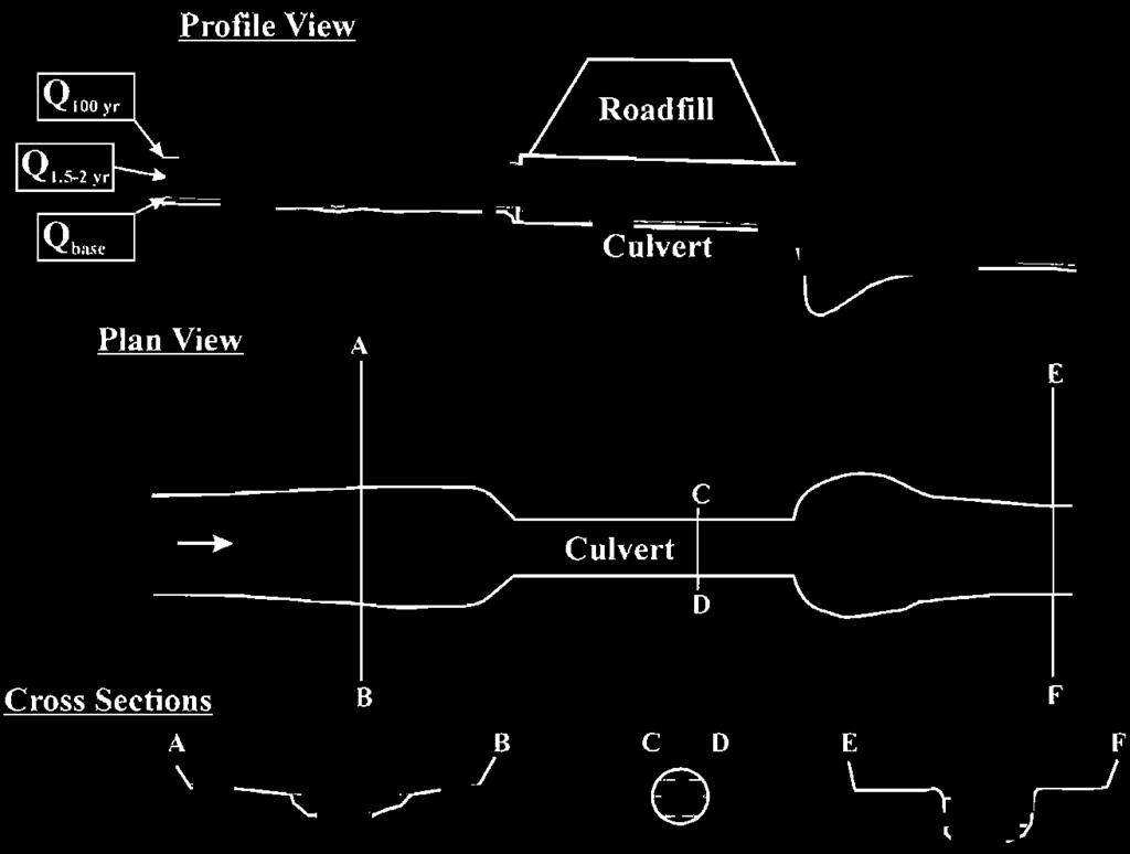
1 Added Introduction: Comparing highway design and stream design Highway width is sized for the traffic, the width expanding as volume and speed increase. The ROW width is also designed to handle the speed and travel distance of vehicles careening off the pavement and allowing room for a safe stop. Natural stream channels also have a characteristic bankfull width and a floodprone width that contains the floodplain. The floodplain allows the channel and its valley to handle the flow of water and sediment during floods where the velocity slows and sediment is then deposited on its floodplain. It s also the place fish go during floods to escape the high channel velocities. In a very real sense, both highways and streams have an entrenchment ratio (or confinement ratio) where the width containing fast flowing material is bordered by a region where flow is slowed and material is stopped. Friends of the St. Joe Association - October 14, 2011
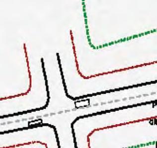
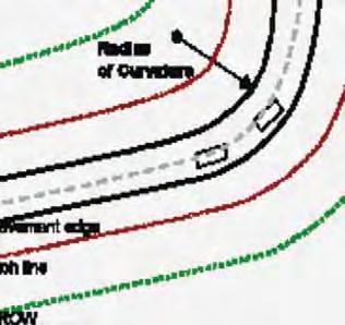
2 The cross section of a highway prism is virtually the same as an upside down stream
3 The highway confinement ratio = ROW Prism Width Stream entrenchment ratio = Floodprone Bankfull width
4 We wouldn t think of doing this on a highway because it would endanger the drivers and their passengers.


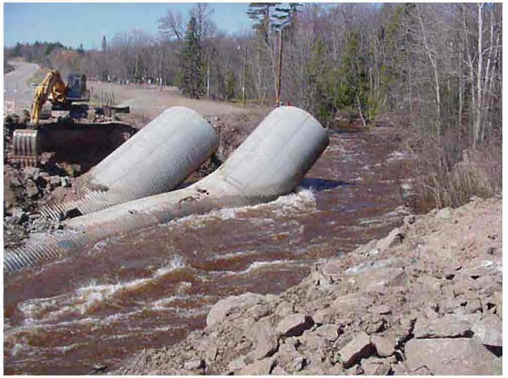
5 However we do it on a regular basis when under-sizing culverts and this endangers both big and little fish
6 The Read the River - - -Mesboac Terrace Stream Floodplain approach to culvert design Terrace Using Stream Geomorphology and Biology Road Integrity, Safety, and Maintenance Not the least expensive culvert, the least expensive life cycle (for roads & fish) Developed by: Dr. Sandy Verry


 stream sinuosity) Consider Headcuts and Cut-Offs Dr.")
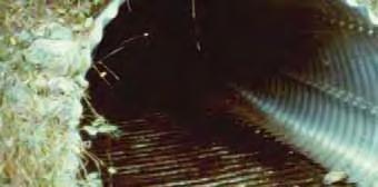
7 Sizing & Placement of Stream Culverts The Stream Will Tell You! Match Culvert Width to Bankfull Stream Width Extend Culvert Length through side slope toe Set Bury Culvert Slope same as Stream Slope Culvert 1/6 th Bankfull Stream Width Offset Multiple Culverts (floodplain ~ splits lower buried one) Align Culvert with Stream (higher one (or ~ dig 1 ft. with higher) stream sinuosity) Consider Headcuts and Cut-Offs Dr. Sandy Verry Chief Research Hydrologist Forest Service
8

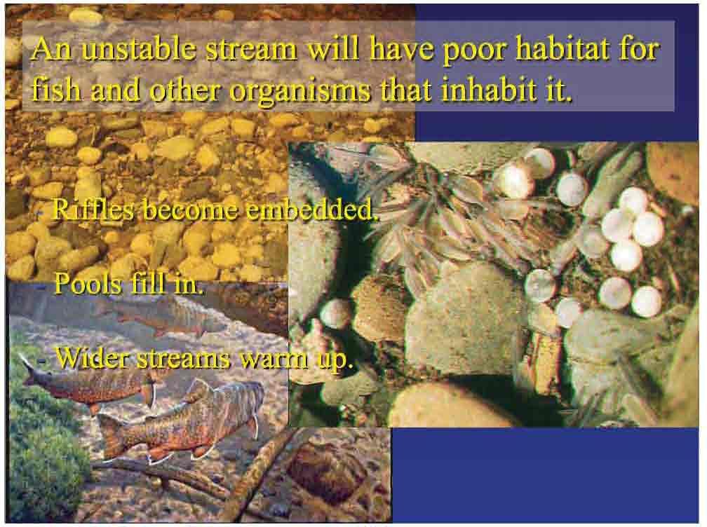
9 Why is stream stability important?
10 The Read The River Mesboac method can handle most culvert design needs But we all know each specific culvert site needs adjustment to achieve a long-term, functional installation Both the professional stream geomorphology approach using Mesboac and professional engineering hydraulic programs can ensure meeting both road and fish criteria Use culvert and channel flow programs as needed, e.g. HEC-RAS, Culvert Master, Flow Master ( FishXing, WinXSPro from Stream Team ( FishPass (Alaska DOTPF, C. E. Behlke, Fairbanks )
11 Historical Perspective on Culvert Design Hydraulic design approach Minimum size for a given design storm (initial culvert cost) Overtopping (protecting the road prism) Storage (using the road & flat valleys to store floodwater temporarily) Lack of cross-discipline communication Even so, centered on adult trout or salmon New stream geomorphology & stream biology knowledge
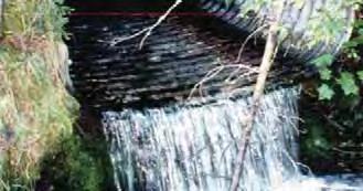
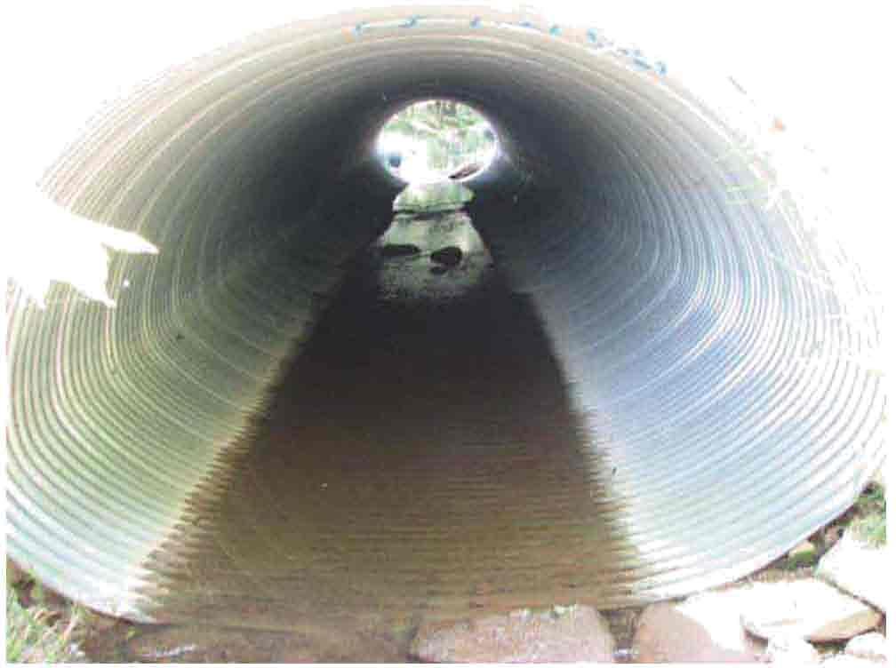
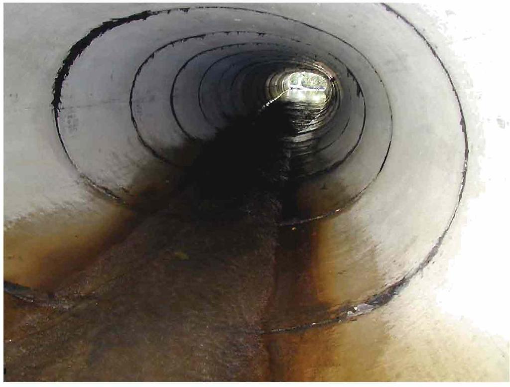
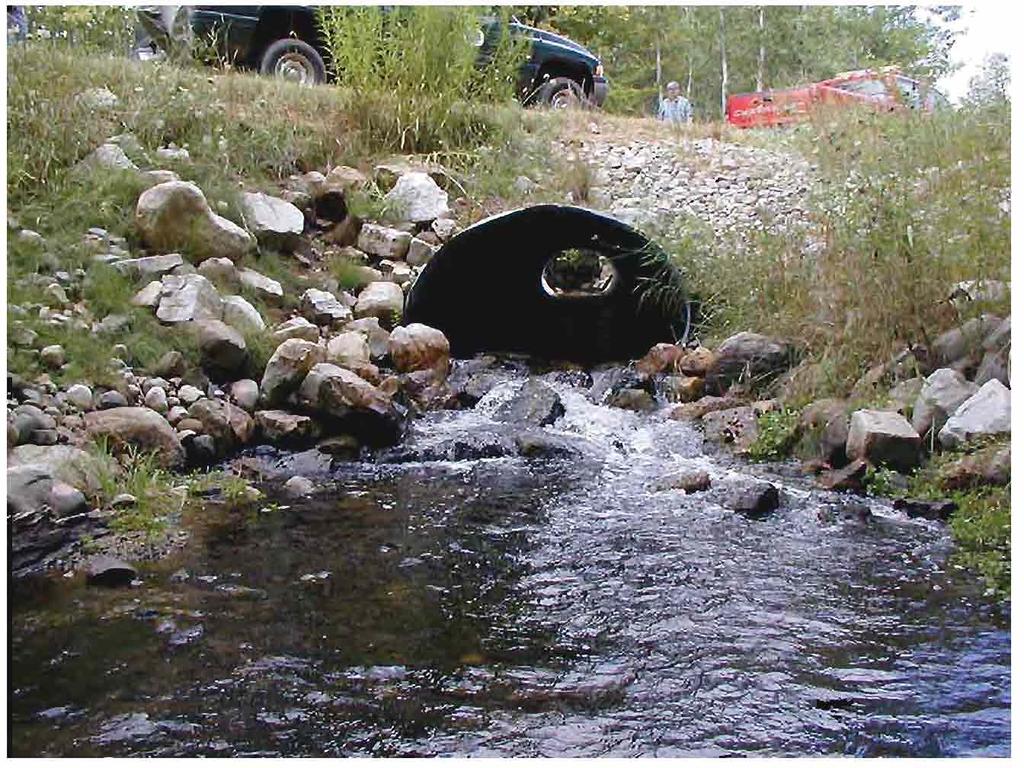
12 Narrow culverts: Enhance erosion of channel sides Cause backwater conditions upstream increasing inlet head and thus exit velocities Scour the outlet pool Saturate the road fill leading to excessive flex during spring snowmelt or snow on rain events Can lead to culvert piping along the outside of the culvert and then road failure Can lead to unnecessary overtopping and road failure Road failure at one site can trigger a domino effect on downstream crossings Wide culverts lessen debris or bedload blockage Wide culverts minimize channel aggradation upstream
13
14
15
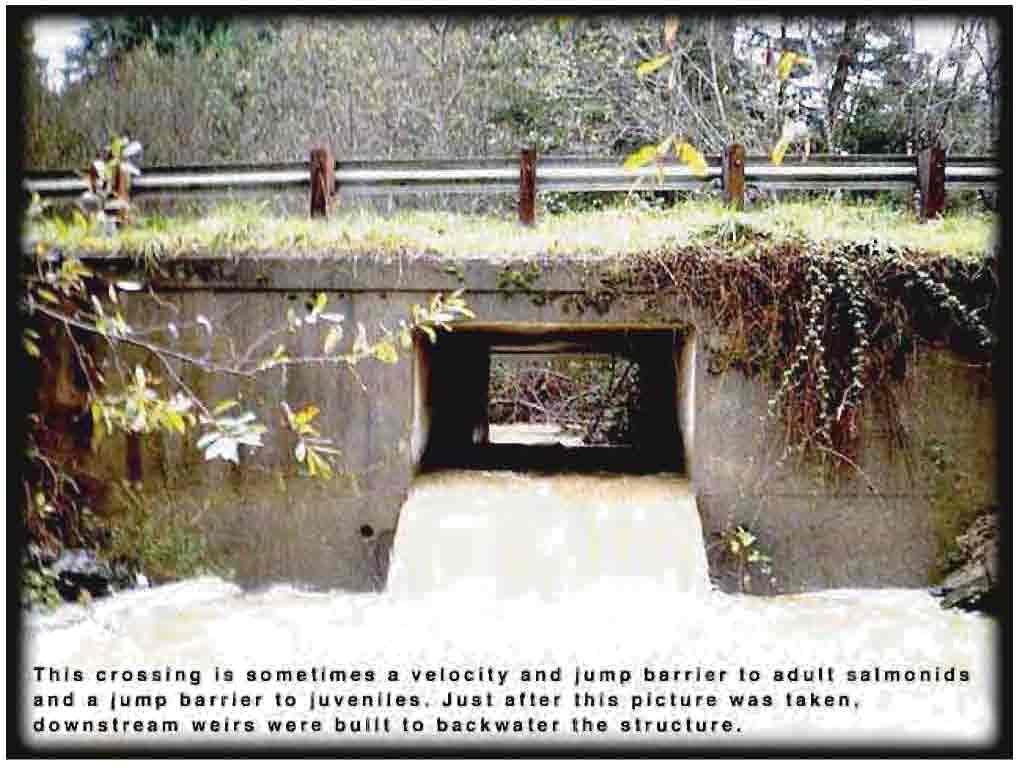
16 Fundamental Stream and Culvert Interactions Fish and other aquatic organisms live and travel primarily along the channel margins. This is the environment under which they evolved and developed their swimming capabilities: 0-3 feet/sec When culverts less than the bankfull width restrict flow at a road prism, exit velocities from the culvert easily reach 5 feet/sec I have measured some up to 11 1/2 feet/sec
17 Mesboac Match the Width Stream shape (size) derives from natural watershed process that physically shape the channel to a characteristic width and depth The channel, so shaped, will carry the water, sediment, and debris of the watershed under similar conditions of climate and land use and remain stable in its sinuosity, w/d ratio, cross section area, and pool/riffle structure
18 Stream width is determined by: The Bankfull Discharge (flow) Texture of the material in the stream bottom and the stream banks Clays and peats tend to have narrow width/depth ratios (< 12,) Sands and gravels tend to have wider width/depth ratios (>12) Regardless of the w/d ratio match culvert width to bankfull stream width
19 Fundamental Stream Channel Interactions The highest stream velocities occur in the channel away from the sides and bottom The irregular sides and bottom with rocks, woody debris, vegetation, etc. have lower velocities of 0-3 feet/sec Average stream velocities at the bankfull stage are 3 6 feet/sec Generally 3 ft/sec when channel slopes are less than 1%. The average velocity goes up as channel slope increases above 1%
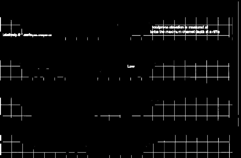
20 Max.Channel Depth Indices of Flow for the Eastern United States Recurr. Interval d/dmax bkf Q/Q bkf / /2 2 Bankfull (1.5) 1 1 Ave. Flow 1/4 0.2 Est. from Leopold, Luna B A view of the river. Harvard Univ. Press. Cambridge, Ma 298p.
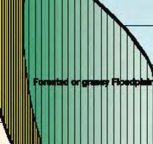
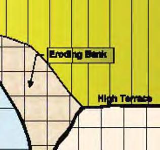
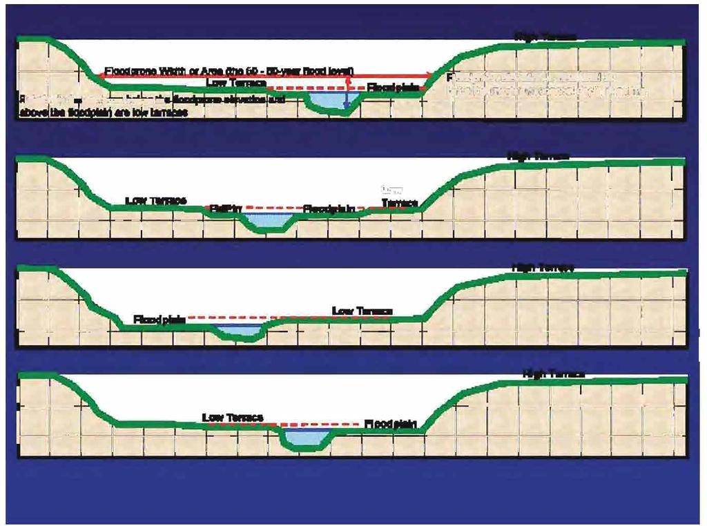
21

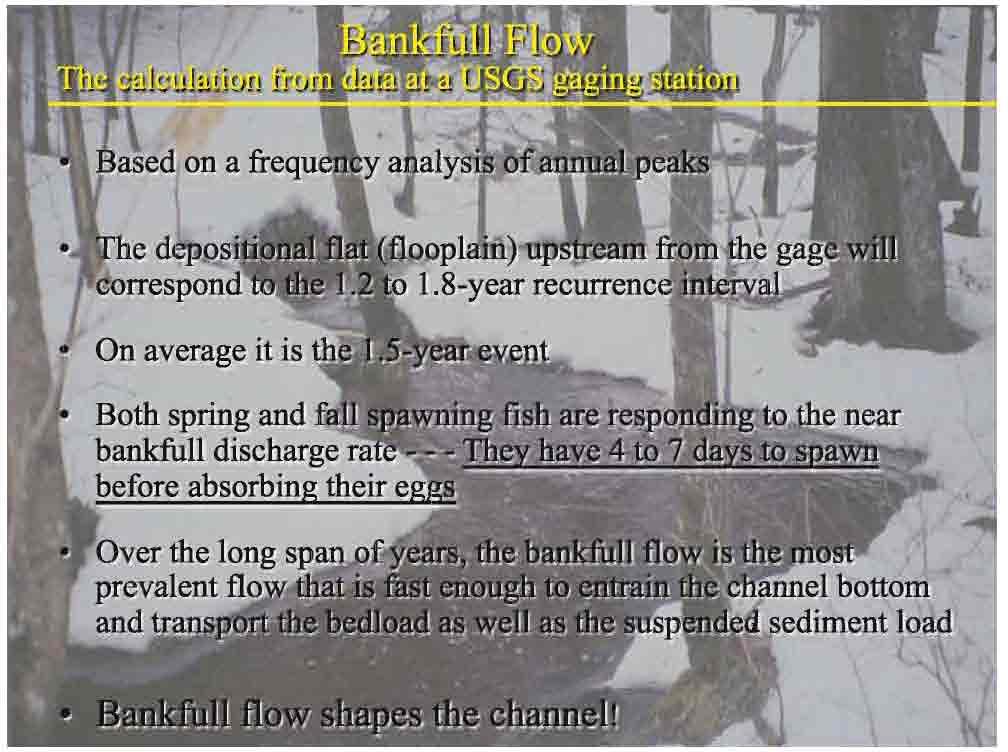
22 The most effective sediment discharge, over time, occurs, at the bankfull flow rate or approx. the 1.5-year recurrence interval At the bankfull flow, the stream bottom picks up and moves, then redistributes its self in the same pool & riffle patterns existing prior to the bankfull discharge. Very large cobble & boulders excepted


23 Circulation cells, fully developed during bankfull discharge, shape the channel!

24 Bankfull
25
26
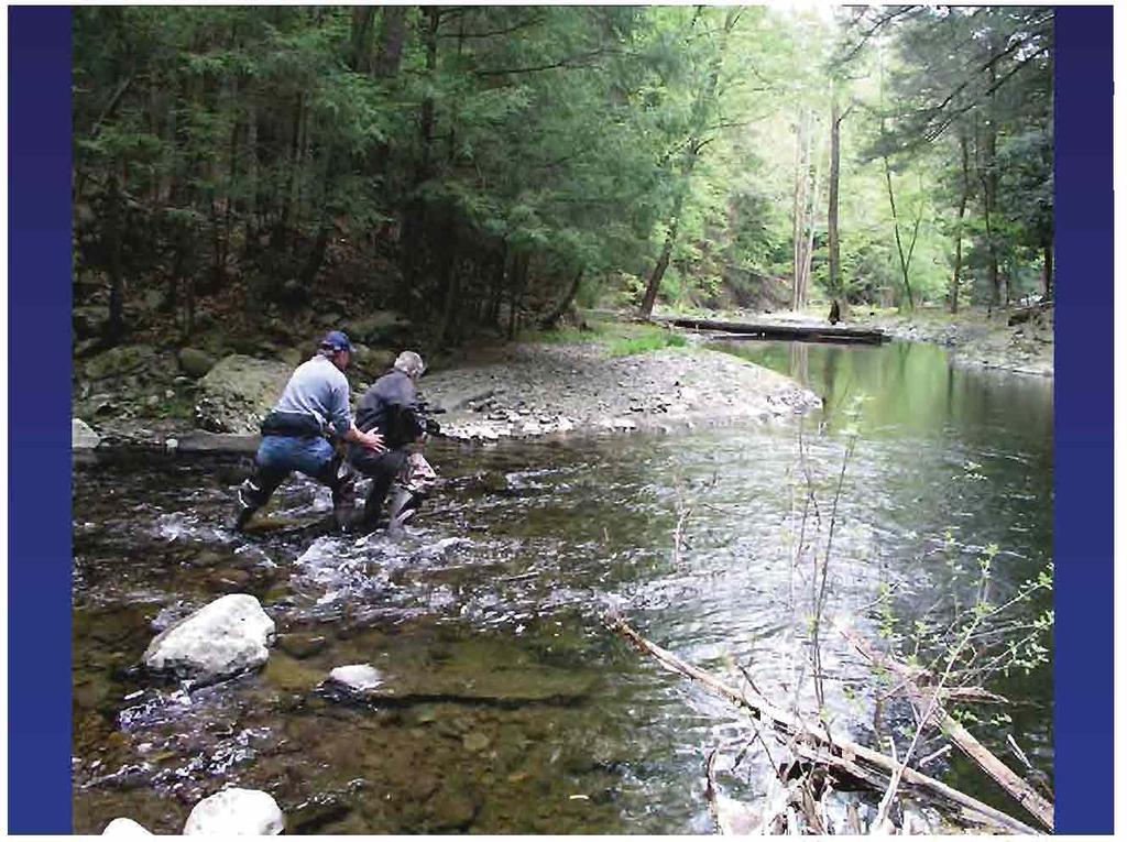
27
28 Mesboac Culvert Design Match Bankfull width
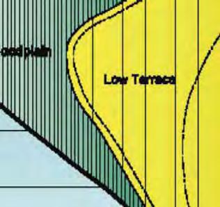
29 Measure Bankfull Width at the Narrowest Point on the channel Measure at the floodplain elevation regardless of where the water level is Terrace Floodplain
30 Avoid Width Measurements at the road on existing sites Widening due to aggradation Widening due to scour Measure at the narrowest point on the channel away from the existing crossing
31 Bankfull Width
32 Mesboac Culvert Design Match Extend Culvert to side Bankfull slope toe width
33 Mesboac Culvert Design Match Extend Culvert to side Bankfull slope toe width Set on Channel Slope

 is the single reason")


34 Failure to set culverts on the same slope as the stream (and bury them 1/6 th width BKF ) is the single reason that many culverts do not allow for fish passage! Slope can be measured as: Slope along the bank (wider variation, than thalweg) Slope of the water surface (big errors at low flow or in flooded channels, good at moderate to bankfull flows) Slope of the thalweg (this, by far, is the best one)
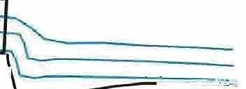
35 Measure a longitudinal profile to allow the precise placement of culverts. Also do several channel cross sections along the way. Precision Setting riffle At each point 1. Bankfull 2. Water surface 3. Thalweg True North Backsight Benchmark riffle riffle riffle is the key to a fully functional culvert installation Setting the elevation of the culvert invert upstream & downstream assures success! riffle riffle Measure Bankfull elevation, water surface elevation, and major thalweg topographic breaks (riffle top, riffle bottom, pool bottom), at each station, on the longitudinal profile
36 1997 LITTLE POKEGAMA CREEK PLOT 7 LONGITUDINAL ELEVATION-FT slope = Bankfull elevation Slope = for 47 to 360 Water Surface elevation 994 Thalweg elevation THALWEG DISTANCE-FT
37 Mesboac Culvert Design Match 0 3 Extend Culvert to side Bankfull slope toe width Set on Channel Slope 6 Bury 1/6 th of Bankfull stream width Road Surface 2 ft min. 1/6 th width bkf
38 Mesboac Bury the Culvert Bed inside culvert is about 1/6th the bankfull stream width This is based on the scour depth of streams, so it doesn t need to exceed 2 feet max Let the bankfull discharge that lifts the stream bottom carry both the water and the sediment through the culvert, mimicking the hydraulics of the channel


39 1997 LITTLE POKEGAMA CREEK PLOT 7 LONGITUDINAL Subtract burying depth from these elevations to find the elevation of the inverts ELEVATION-FT Bankfull elevation Slope = Water Surface elevation 994 Thalweg elevation THALWEG DISTANCE-FT 1. A line connecting the thalweg riffle points from above and below the crossing site is the most accurate estimate of stream bottom

40 Mesboac Culvert Design Match 0 3 Extend Culvert to side Bankfull slope toe width Set on Channel Slope 6 Bury 1/6 th of Bankfull stream width Road Surface Offset Culvert Multiples 1/6 th width bkf 2 ft min. 7 inch min., Plan on a foot if your not too close to the road surface

41 When using multiples, use the fewest and largest multiples possible

42 Undersized culverts (say one of these) will flow at 7 to 12 ft per second during spawning, bankfull flows Culverts that match stream width, flow at 3 ft per second during spawning, bankfull flows Fish swim at 3 to 5 feet per second


43 Culvert width is only 1/3 rd of Channel Width Combined Culvert Width Matches Channel Width
44 Match Mesboac Culvert Design Extend Culvert Bankfull width through the side slope toe Set Culvert same as Channel Slope Bury 1/6 th of Bankfull stream width Align with channel Solid material
45 Read the River Alignment First Choice: Align culvert with the channel Upland Shallow Peat Over Sand
46 First Choice: Align culvert with the channel But: Avoid pointing the culvert at a Terrace slope 5 ft Shallow Peat Over Sand Try to keep the culvert and the immediate channel, 10 to 15 feet away from the terrace slope Upland Read the River Alignment
47 Match Mesboac Culvert Design Extend Culvert Bankfull width through the side slope toe Set Culvert same as Channel Slope Bury 1/6 th of bankfull stream width Align with channel Consider headcut Solid material
48 Reduced length = Increased slope = Increase in energy = Potential for head-cut
49 No culvert Improperly set culvert Aggradation Culvert replaced properly Scour pool Note gradient increase Stream Thalweg Stream Slope Culvert

50 Rate of Channel Adjustment Siegel Ck, LNF 1998 Siegel Ck, LNF 1998

51 Channel Responses To An Undersized Culvert
52 Read The River Bankfull-Method Mesboac Channel Velocity: Manning Equation: V = 1.5/n R 2/3 S 1/2 V = Velocity in feet per second R = Hydraulic Radius = Xsec Area/Wetted Perimeter S = Energy Slope ~ Thalweg Riffle Slope n = Manning s n for a roughness factor (0.030, 0.035, up to 0.05) Channel Discharge: Discharge = V ( XsecArea) (Calculate the Bankfull Q) Check your headwater levels with a culvert program at various flow events. Bankfull Discharge x 3 = Q25 Bankfull Discharge x 4 = Q50
53 Read The River, Bankfull Mesboac Method Use HEC-RAS, Flowmaster or WinXSPro to estimate channel discharge Use Culvertmaster or FishXing to estimate culvert exit velocity * These will give you not only the variables on the previous slide, but water height at the inlet and outlet of the culvert * Check for agreement with Mesboa criteria, and check data if they disagree by more than 20%


54 The difficulty lies not in the new ideas, but in escaping from the old ones. John Maynard Keyes 1936

55
56

57

58 DEQ 12, Tributary to Davis Creek at Townline Road.

59 DEQ 12, Tributary to Davis Creek at Townline Road looking upstream.

60 DEQ 13, UnNamed Tributary to Dennis Creek looking downstream.

61 DEQ 14, Dennis Creek at Fountain Road looking downstream.

62 DEQ 14, Dennis Creek at Fountain Road looking downstream.

63 DEQ 14, Dennis Creek at Fountain Road looking upstream.

64 DEQ 14, Dennis Creek at Fountain Road just upstream of culvert failure.

65 DEQ 23, Black Creek at Johnson Road looking west.

66 DEQ 23, Black Creek at Johnson Road looking upstream.
67

68 DEQ 1, Gurney Creek looking south.

69 DEQ 1, Gurney Creek looking at culverts washed out in Lake Michigan.

70 DEQ 4, Olson Creek looking west toward culvert.

71 DEQ 4, Olson Creek looking downstream.

72 DEQ 5, Olson Creek looking downstream.

73 DEQ 5, Olson Creek looking upstream.

74 DEQ 18, UnNamed Tributary to Middle Bayou looking upstream.

75 Culvert on Angling Road looking downstream to DEQ 18, UnNamed Tributary to Middle Bayou fish passage blockage with rock riffle.

76 DEQ 22, Looking south across UnNamed Tributary to Middle Bayou at Lincoln Road.

77 DEQ 22, UnNamed Tributary to Middle Bayou looking downstream.
78
79
80
81
82


83 Smith Creek Blandin Paper Co. So. of Grand Rapids MN Perched, 12 ft.-wide wooden box culvert replaced with 18 ft. Bottomless Arch Culvert
84
85
86 Blowouts tend to occur in deep valleys with a low valley width/depth ratio when the road fill approaches and exceeds 10 feet? ~ 75-yr level? Floodplain culvert same size as stream culvert. Set same as floodplain slope Stream culvert sized To bankfull width. Set same as thalweg riffle slope


87 New Bridge and Flood Relief Culverts on the Dark River St. Louis County, MN DNR, And Superior Nat. Forest
88
89 Economics? The initial cost of designing for fish passage is higher, because the culvert is bigger. However,.. Failure risks are reduced Structural life is optimized Maintenance levels are reduced, and... Replacement frequency declines Creating opportunities for work at other sites
90 Reality Check Having the least expensive crossing alternative and still maintaining fish passage, stream function, maximized structural life, and minimum maintenance cost is unrealistic Integrating culverts, streams, and fish passage is a win-win scenario that leads to more viable fish populations, healthier streams, and engineering maintenance budgets that can focus resources elsewhere Do it for the big picture, for the long haul, first With a little luck, you won t need to come back!
91
92

93 Denomie Creek, Baraga County outlet.

94 Pekkala Creek through culvert looking downstream.

95 UnNamed trib to Dickerson Creek, Ionia County through culvert looking downstream.

96 Quaker Brook, Barry County channel relocation and inlet of culvert.

97 Quaker Brook looking upstream from stream relocation to natural channel.
98
99

100 Quaker Brook through culvert looking downstream.

101 McBride Drain, Shiawassee County outlet.

102 McBride Drain, Shiawasee County inlet.

103 Sweet & S Mine Drain looking upstream through culvert.

104 Evans Creek, Lenawee County looking downstream through culvert.

105 Indian Creek, Monroe County inlet.

106 McIntyre Drain, Washtenaw County inlet.

107 Arner Creek, Manistee County outlet.

108 Second Creek, Manistee County outlet.

109 Larson Creek, Marquette County inlet.

110 Gomanche Creek, Baraga County inlet.
Joe Rathbun Michigan DEQ Water Resources Division Nonpoint Source Unit * Thanks to The Nature Conservancy
 Joe Rathbun Michigan DEQ Water Resources Division Nonpoint Source Unit rathbunj@mi.gov * Thanks to The Nature Conservancy Road-stream intersections = 67,511 Culverts = 60,700 Bridges = 6,811 Perched Piping
Culvert Design for Low and High Gradient Streams in the Midwest. Dale Higgins, Hydrologist Chequamegon-Nicolet National Forest
 Culvert Design for Low and High Gradient Streams in the Midwest Dale Higgins, Hydrologist Chequamegon-Nicolet National Forest Overview Culvert Design Considerations Hydraulic Terms Culvert Impacts Low
Aquatic Organism Passage at Road-Stream Crossings CHUCK KEEPORTS FOREST HYDROLOGIST ALLEGHENY NATIONAL FOREST WARREN, PENNSYLVANIA
 Aquatic Organism Passage at Road-Stream Crossings CHUCK KEEPORTS FOREST HYDROLOGIST ALLEGHENY NATIONAL FOREST WARREN, PENNSYLVANIA TOPICS COVERED Aquatic Organism Passage (AOP) Benefits of AOP Crossings
Understanding the Impacts of Culvert Performance on Stream Health
 Understanding the Impacts of Culvert Performance on Stream Health Kristin Thomas Aquatic Ecologist Michigan Trout Unlimited Transportation and the Environment Conference 12/5/2018 Importance of adequately
HEC 26 Aquatic Organism Passage Design Manual Evolution & Application
 HEC 26 Aquatic Organism Passage Design Manual Evolution & Application Sven Leon, P.E., Hydraulics Engineer Federal Highway Administration 2015 Alaska Fish Passage Meeting October 13 14, 2015 VTRC, Juneau,
Presented by Fred Halterman, URS Jennie Agerton, URS
 Presented by Fred Halterman, URS Jennie Agerton, URS What is Eco Friendly Culvert Design? Culvert design that: Maintains connectivity for aquatic organism migration Maintains connectivity for gene flow
Assessment of Baseline Geomorphic Features at. Proposed Stream Crossings On The Proposed County Road 595. Marquette County, Michigan
 Assessment of Baseline Geomorphic Features at Proposed Stream Crossings On The Proposed County Road 595 Marquette County, Michigan Prepared for: Kennecott Eagle Minerals Company Marquette, Michigan Prepared
Stream Assessment. Date. Data Collected by. Location. Name of Stream and River Basin. Stream Order. Streambank Materials. Streambank Vegetation
 Stream Assessment Date Data Collected by Location Name of Stream and River Basin Stream Order Streambank Materials Streambank Vegetation Floodplain Soils Floodplain Vegetation Valley Type Valley Constraints
Geomorphic Stream Classification A Classification of Natural Rivers, Rosgen, D.L.
 Geomorphic Stream Classification A Classification of Natural Rivers, Rosgen, D.L. Why is Stream Classification Physical stream channel evolution Essential? Similar stream types manifest similar patterns
CALIFORNIA SALMONID STREAM HABITAT RESTORATION MANUAL APPENDIX IX-A CULVERT CRITERIA FOR FISH PASSAGE INTRODUCTION
 APPENDIX IX-A STATE OF CALIFORNIA RESOURCES AGENCY DEPARTMENT OF FISH AND GAME CULVERT CRITERIA FOR FISH PASSAGE For habitat protection, ecological connectivity should be a goal of stream-road crossing
(Revised February,2005) CULVERTS, BRIDGES, AND FORDS
 CULVERTS, BRIDGES, AND FORDS") GUIDE TO STREAM CROSSINGS (Revised February,2005) CULVERTS, BRIDGES, AND FORDS Culverts, bridges, and fords are all methods used to cross-streams. Culverts are the most common stream crossing structure.
GUIDE TO STREAM CROSSINGS (Revised February,2005) CULVERTS, BRIDGES, AND FORDS Culverts, bridges, and fords are all methods used to cross-streams. Culverts are the most common stream crossing structure.
Fish Friendly Crossings- Examples from Nash Stream
 Fish Friendly Crossings- Examples from Nash Stream Maggie Machinist- North Regional Forester, Division of Forests and Lands. Nash Stream Nash Stream Forest is 40,000 acres, owned and managed by NH Division
Massachusetts Stream Crossing Case Studies
 Massachusetts Stream Crossing Case Studies Amy Singler Associate Director, River Restoration Program Carrie Banks River Continuity Coordinator Case Studies: Public Benefits: Movement of goods and people
Simulating Streams Through Culverts in Mat-Su, Alaska
 Simulating Streams Through Culverts in Mat-Su, Alaska Project Managers Bill Rice, P.E., USFWS Hydrologist Mary Price, USFWS Fishery Biologist The Team Approach US Fish and Wildlife Service Bill Rice, P.E.,
OFFICE OF STRUCTURES MANUAL FOR HYDROLOGIC AND HYDRAULIC DESIGN CHAPTER 13 CULVERTS APRIL 2011
 OFFICE OF STRUCTURES MANUAL FOR HYDROLOGIC AND HYDRAULIC DESIGN CHAPTER 13 CULVERTS APRIL 2011 APRIL 2011 Chapter 13 Culverts Table of Contents Foreword.3 13.1 Introduction.. 4 13.2 Policy 6 13.3 Passage
Fish Passage Assessment of Private Stream Crossings on Lower Stonybrook Creek
 Fish Passage Assessment of Private Stream Crossings on Lower Stonybrook Creek Prepared by: Michael Love & Associates In cooperation with: Center for Ecosystem Management and Restoration Funded by: Coastal
Culvert Design An Overview of the NYS Highway Design Manual Chapter 8
 Seventeenth Statewide Conference on Local Bridges Culvert Design An Overview of the NYS Highway Design Manual Chapter 8 Tuesday, October 25, 2011 Training Session: Culvert Design, Analysis - talk 2 Presented
Water surface slope extending up to 20 channel widths up and downstream of crossing.
 Site Evaluations Site Information Site Location: Mt ood NF, Forest Road 7 Year Installed: Pre-987 Lat/Long: 8 W Watershed rea (mi ): N Stream Slope (ft/ft) : Channel Type: Step-pool ankfull Width (ft):
Rehabilitation of Grimes Creek, a Stream Impacted in the Past by Bucket-lined Dredge Gold Mining, Boise River Drainage, July 2008 to August 2011.
 Rehabilitation of Grimes Creek, a Stream Impacted in the Past by Bucket-lined Dredge Gold Mining, Boise River Drainage, July 2008 to August 2011. Pam Harrington TU,1020 W. Main Street Suite 440, Boise,
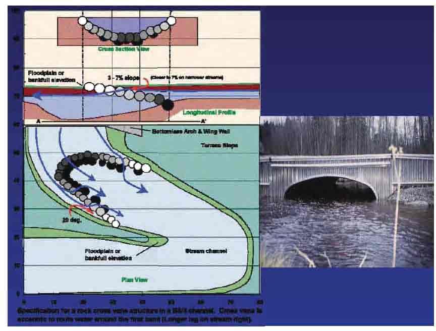
Cross-Vane Plan View FIN-UP Habitat Consultants, Inc. 220 Illinois Avenue Manitou Springs, CO (719) P.
 P.") STREAM CHANNEL STRUCTURE DRAWINGS ISIONS W (Channel Width) (Varies) Thalweg & Flow Direction Individually Placed Footer Rocks 5' to 6' by 2' thick (Min. 2 rows of footer rocks placed tightly together with
STREAM CHANNEL STRUCTURE DRAWINGS ISIONS W (Channel Width) (Varies) Thalweg & Flow Direction Individually Placed Footer Rocks 5' to 6' by 2' thick (Min. 2 rows of footer rocks placed tightly together with
Habitat Conditions, Design Strategies,
 Habitat Conditions, Design Strategies, Coho on Cedar Ck. five years after analog-based stream restoration work. and Stream Classification In river work, computer modeling is an insidious procedure in which
RESTORING THE CONNECTION BETWEEN CREEK AND LAKE: FRESH WATER ESTUARINE CREATION IN MISSISSAUGA
 RESTORING THE CONNECTION BETWEEN CREEK AND LAKE: FRESH WATER ESTUARINE CREATION IN MISSISSAUGA Jeff Doucette, Kenneth Dion and Sally-Beth Betts 6 th International Conference on Natural Channel Systems
Five Counties Salmonid Conservation Program - Fish Passage Design Workshop. February 2013
 Program - Aquatic Organisms and Stream Crossings Ecological Connectivity A watershed is a network of channels that drain a common boundary. Channel characteristics formed by interaction of precipitation,
FINAL REPORT. Yonkers Creek Migration Barrier Removal Project Wonderstump Road Del Norte County. Submitted By:
 FINAL REPORT Yonkers Creek Migration Barrier Removal Project Wonderstump Road Del Norte County Submitted By: Del Norte County Community Development Department Yonkers Creek Migration Barrier Removal Project
Incorporating Geomorphic Processes and Sediment Dynamics into Salmonid Habitat Restoration Design
 Salmonid Restoration Federation 35 th Annual Salmonid Restoration Conference Davis, CA Incorporating Geomorphic Processes and Sediment Dynamics into Salmonid Habitat Restoration Design Concurrent Session:
APPENDIX J HYDROLOGY AND WATER QUALITY
 APPENDIX J HYDROLOGY AND WATER QUALITY J-1 Technical Report on Airport Drainage, Northern Sector Airport and Ordinance Creek Watershed / Preliminary Creek Constructed Natural Channel Culvert J-2 Preliminary
SELBY CREEK SILVERADO TRAIL CULVERT FISH PASSAGE ASSESSMENT
 SELBY CREEK SILVERADO TRAIL CULVERT FISH PASSAGE ASSESSMENT NAPA COUNTY, CALIFORNIA PREPARED BY NAPA COUNTY RESOURCE CONSERVATION DISTRICT 1303 JEFFERSON ST. SUITE 500B NAPA, CALIFORNIA 94559 WWW.NAPARCD.ORG
Management of headwater streams in the White Mountain National Forest
 Management of headwater streams in the White Mountain National Forest White Mountain National Forest Weeks Act of 1911 authorized the federal government to purchase lands east of the Mississippi River
Indiana LTAP Road Scholar Core Course #10 Culvert Drainage. Presented by Thomas T. Burke, Jr., PhD, PE Christopher B. Burke Engineering, Ltd.
 Indiana LTAP Road Scholar Core Course #10 Culvert Drainage Presented by Thomas T. Burke, Jr., PhD, PE Christopher B. Burke Engineering, Ltd. Objectives Review culvert shapes, end sections, and materials
Climate Change Adaptation and Stream Restoration. Jack Williams;
 Climate Change Adaptation and Stream Restoration Jack Williams; jwilliams@tu.org 1 Goals for this presentation Develop strategies for adapting streams to climate impacts by Thinking like a watershed Understanding
Hydraulic Modeling of Stream Enhancement Methods
 Hydraulic Modeling of Stream Enhancement Methods Matthew J. Curry John J. Levitsky Abstract Development within watersheds increases the amounts of runoff causing stream erosion and degradation of stream
BC Ministry of Forests. March Fish Stream Crossing Guidebook. Forest Practices Code of British Columbia.
 FRST 557 Lecture 7c Bridges and Culverts: Water Velocity and Discharge Lesson Background and Overview: The previous two lessons presented methods for estimating water volume flow at a particular site and
Stream Crossings I: Engineering and Design Approaches to Provide Fish Passage at Culvert Slipline Projects in Connecticut
 University of Massachusetts - Amherst ScholarWorks@UMass Amherst International Conference on Engineering and Ecohydrology for Fish Passage International Conference on Engineering and Ecohydrology for Fish
APPENDIX C ESTIMATING SCOUR IN BOTTOMLESS ARCH CULVERTS
 OFFICE OF STRUCTURES MANUAL FOR HYDROLOGIC AND HYDRAULIC DESIGN CHAPTER 11, EVALUATING SCOUR AT BRIDGES APPENDIX C ESTIMATING SCOUR IN BOTTOMLESS ARCH CULVERTS APRIL 2011 APPENDIX C ESTIMATING SCOUR IN
Minnesota Department of Natural Resources Division of Fish and Wildlife Section of Fisheries. Stream Survey Report. Luxemburg Creek.
 Minnesota F-29-R(P)-24 Area 315 Study 3 March 2016 Minnesota Department of Natural Resources Division of Fish and Wildlife Section of Fisheries Stream Survey Report Luxemburg Creek 2015 Mark Pelham Sauk
Summary of HEC 18, Evaluating Scour at Bridges FHWA NHI Should really follow HEC 18, but this summary will get you the main points.
 Summary of HEC 18, Evaluating Scour at Bridges FHWA NHI 01-001 Should really follow HEC 18, but this summary will get you the main points. 1: Determine scour analysis variables 2: Analyze long-term bed
HY-8 Version 7.2 Build Date January 17, Federal Highway Administration.
 HY-8 Version 7.2 Build Date January 17, 2012 Federal Highway Administration http://www.fhwa.dot.gov/engineering/hydraulics/software/hy8/index.cfm SIMPLE Simple to use Use for simple culverts and bridges
APPENDIX C VEGETATED EMERGENCY SPILLWAY. VERSION 1.0 March 1, 2011
 APPENDIX C VEGETATED EMERGENCY SPILLWAY VERSION 1.0 March 1, 2011 [NOTE: Could use a better photo more clearly showing the emergency spillway in the context of the dam.] SECTION C-1: DESCRIPTION OF PRACTICE
Packwood Hydroelectric Project Barrier Analysis December 12, 2006
 Packwood Hydroelectric Project Barrier Analysis December 12, 2006 Study Area Natural barriers to upstream fish passage on Lake Creek at RM 1.03 and RM 1.95 Snyder Creek culvert under the Project tailrace
SUMMARY OF MOVEMENT AND HABITAT USED BY TAGGED BROOK TROUT IN THE MAIN BRANCH AND NORTH BRANCH AU SABLE RIVER DURING SUMMER Data Submitted to:
 SUMMARY OF MOVEMENT AND HABITAT USED BY TAGGED BROOK TROUT IN THE MAIN BRANCH AND NORTH BRANCH AU SABLE RIVER DURING SUMMER 2014 Data Submitted to: Anglers of the Au Sable Submitted by: Dr. Mark R. Luttenton
TREATING RIVERS RIGHT & EXAMPLES OF BEST USE OF WOOD IN RESTORATION
 TREATING RIVERS RIGHT & EXAMPLES OF BEST USE OF WOOD IN RESTORATION James Mac Cartney, TU River Restoration Specialist John Braico, MD, NY Council Resource Mgr Grassroots Trustee 1 Great Trout Streams
USING A LABYRINTH WEIR TO INCREASE HYDRAULIC CAPACITY. Dustin Mortensen, P.E. 1 Jake Eckersley, P.E. 1
 USING A LABYRINTH WEIR TO INCREASE HYDRAULIC CAPACITY Dustin Mortensen, P.E. 1 Jake Eckersley, P.E. 1 Plum Creek Floodwater Retarding Structure No. 6 is located in an area of Kyle, Texas, that is currently
Hydrologic, Hydraulic and Geomorphic Technical Memorandum
 Appendix A Hydrologic, Hydraulic and Geomorphic Technical Memorandum 01054/8410233/14/Rohner_Alt_Analysis_Report Rohner Creek Flood Control, Habitat and Seismic Improvement Project Alternatives Analysis
Washington State Fish Passage Barrier Removal Projects. Casey Kramer, PE WSDOT State Hydraulics Engineer
 Washington State Fish Passage Barrier Removal Projects Casey Kramer, PE WSDOT State Hydraulics Engineer 2014 National Hydraulic Engineering Conference Iowa City, IA August 20 th, 2014 WSDOT Fish Passage
APPENDIX B HYDRAULIC DESIGN DATA FOR CULVERTS
 TM 5-820-4/AFM 88-5, Chap 4 APPENDIX B HYDRAULIC DESIGN DATA FOR CULVERTS B-1. General. a. This appendix presents diagrams, charts, coefficients and related information useful in design of culverts. The
Plan B Dam Breach Assessment
 Plan B Dam Breach Assessment Introduction In support of the Local Sponsor permit applications to the states of Minnesota and North Dakota, a dam breach analysis for the Plan B alignment of the Fargo-Moorhead
Rock Ramp Design Guidelines. David Mooney MS Chris Holmquist-Johnson MS Drew Baird Ph.D. P.E. Kent Collins P.E.
 Rock Ramp Design Guidelines David Mooney MS Chris Holmquist-Johnson MS Drew Baird Ph.D. P.E. Kent Collins P.E. Rock Ramp Design Guidelines OUTLINE Local and System Interactions with Rock Ramps Ramp Geometry
Great Lakes Stream Crossing Inventory Instructions
 Great Lakes Stream Crossing Inventory Instructions This document is a guide to completing the Stream Crossing Data Sheet (2/28/11 version). Careful attention to this guidance will ensure consistent crossing
TOP:001.3 U.S. Fish and Wildlife Service TECHNICAL OPERATING PROCEDURE
 TOP:001.3 March 12, 2015 U.S. Fish and Wildlife Service Marquette Biological Station 3090 Wright Street Marquette, Michigan 49855 U.S.A. and U.S. Fish and Wildlife Service Ludington Biological Station
General Information for Culvert Design
 Design Manual Chapter 2 - Stormwater 2E - Culvert Design 2E-1 General Information for Culvert Design A. Introduction A culvert is a conduit under an embankment that transports stormwater from one side
Fish Habitat Restoration and Monitoring in Southeast Washington. Andy Hill Eco Logical Research, Inc.
 Fish Habitat Restoration and Monitoring in Southeast Washington Andy Hill Eco Logical Research, Inc. Fish Habitat Restoration and Monitoring in Southeast Washington Talk overview: Restoration projects
Modeling of Long Culverts and Stormdrains A Comparison of Different Methods
 Modeling of Long Culverts and Stormdrains A Comparison of Different Methods Shrinivas Kaulgud, P.E., CFM Cheryl Hannan, P.E., CFM, LEED AP October 12, 2017 Presentation Outline Introduction Case Studies
Minnesota Department of Natural Resources Division of Fish and Wildlife Section of Fisheries. Stream Survey Report. Three Mile Creek 2011
 Minnesota Department of Natural Resources Division of Fish and Wildlife Section of Fisheries Stream Survey Report Three Mile Creek 2011 By Joseph D. Stewig Montrose Area Fisheries Office TABLE OF CONTENTS
CHAPTER 4 SPALDING COUNTY, GEORGIA 4.0 CULVERT DESIGN
 SPALDING COUNTY, GEORGIA CHAPTER 4 4.0 CULVERT DESIGN... 4-1 4.1 INTRODUCTION... 4-1 4.2 SYMBOLS AND DEFINITIONS... 4-1 4.3 ENGINEERING DESIGN CRITERIA... 4-2 4.3.1 FREQUENCY FLOOD... 4-2 4.3.2 VELOCITY
Discussion on the Selection of the Recommended Fish Passage Design Discharge
 Discussion on the Selection of the Recommended Fish Passage Design Discharge Introduction The provision of fish passage is a requirement for most proposed culvert and bridge installations in Alberta, depending
Quantifying Performance of Stream Simulation Culverts in the Chehalis Basin, WA
 Quantifying Performance of Stream Simulation Culverts in the Chehalis Basin, WA AUTHORS: Joe Richards, Environmental Science Associates Jane Atha, Washington Department of Fish & Wildlife Colin Thorne,
CHAPTER 5 CULVERT DESIGN
 CHAPTER 5 CULVERT DESIGN HYDRAULICS OF CULVERTS There are two major types of culvert flow: 1) flow with inlet control, and 2) flow with outlet control. For each type, different factors and formulas are
Design Report for Janes Creek Roughened Channel
 August 12, 2005 Design Report for Janes Creek Roughened Channel Table of Contents Project Description...1 Overview of Report...1 Background...2 Design Flows...3 Roughened Channel Design...6 Fish Passage
STREAM CROSSING INVENTORY AND BARRIER RANKING GUIDELINES
 STREAM CROSSING INVENTORY AND BARRIER RANKING GUIDELINES Fax: 218-739-7601 E-mail: amanda.hillman@state.mn.us Amanda Hillman, Restoration Coordinator Minnesota Department of Natural Resources Division
DRAFT. Stonybrook Creek Watershed
 DRAFT Stonybrook Creek Watershed A Strategic Plan for Eliminating Barriers to Steelhead Migration June 4, 2010 Prepared by: PO Box 4477, Arcata, CA 95518 mlove@h2odesigns.com / (707) 476 8938 Prepared
Storm Damage Floating Culverts & Other Inlet Issues
 Storm Damage Floating Culverts & Other Inlet Issues Mark Bailey, PE - Hydraulic Manager, INDOT Dale Sedler, PE - Sr. Hydraulic Engineer, INDOT Road School 2016 What causes a culvert to float? 1. Accumulation
PROJECT TO INSTALL LARGE WOOD HABITAT STRUCTURES IN THE CARMEL RIVER USING CALIFORNIA DEPARTMENT OF FISH AND GAME GRANT FUNDS
 PROJECT TO INSTALL LARGE WOOD HABITAT STRUCTURES IN THE CARMEL RIVER USING CALIFORNIA DEPARTMENT OF FISH AND GAME GRANT FUNDS The Monterey Peninsula Water Management District (MPWMD), in cooperation with
Sediment Basin 7E-12. Design Manual Chapter 7 - Erosion and Sediment Control 7E - Design Information for ESC Measures BENEFITS.
 7E-12 Design Manual Chapter 7 - Erosion and Sediment Control 7E - Design Information for ESC Measures Sediment Basin BENEFITS Flow Control Erosion Control Sediment Control Runoff Reduction Flow Diversion
JAP Additional Information Sheet
 JAP Additional Information Sheet Block 15: Purpose and Need The USACE purpose of the project is to provide a safe and reliable whitewater park for the recreational public in a city park, which will provide
Michigan Department of Natural Resources Status of the Fishery Resource Report Page 1
 Michigan Department of Natural Resources 2008-59 Status of the Fishery Resource Report Page 1 Bowens Manistee County, (T24N R16W Sec. 11, 12, 13, 14, 15, 24, and 30). Last surveyed 2008 Mark A. Tonello
Cornwell brook Cornwell Manor
 Cornwell brook Cornwell Manor An Advisory Visit by the Wild Trout Trust February 2014 1 1. Introduction This report is the output of a Wild Trout Trust visit to a tributary of the Cornwell Brook at Cornwell
STREAM SURVEY File form No..
 scanned for KRIS THE RESOURCES AGENCY OF CALIFORNIA California Department of Fish and Game STREAM SURVEY File form No.. Date: September 4, 1969. NAME: North Fork Schooner Gulch Creek COUNTY: Mendocino.
Technical Report Culvert A Hydraulic Analysis
 DATE: November 3, 2011 Technical Report Culvert A Hydraulic Analysis TO: FROM: RE: Jim Reiser, P.E. Project Manager Parsons Brinckerhoff, Inc. Kurt Killian, P.E., CFM Parsons Brinckerhoff, Inc. Design
MCCAW REACH RESTORATION
 Final Report MCCAW REACH FISH RESTORATION PHASE B Jack McCaw Inland Empire Action Coalition http://www.wwccd.net/ Phone: 509-956-3777 Hours: 8:00-4:30 Walla Walla County Conservation District Snake River
STRUCTURE S-65 PURPOSE SPILLWAY OPERATION
 STRUCTURE S-65 This structure is a reinforced concrete, gated spillway with discharge controlled by three cable operated, vertical lift gates, and a reinforced concrete lock structure with two pairs of
Big Spring Creek Habitat Enhancement and Fishery Management Plans
 Big Spring Creek Habitat Enhancement and Fishery Management Plans November 5, 2012 Big Spring Events and Activities Center Newville, PA Charlie McGarrell Regional Habitat Biologist Pennsylvania Fish and
Tips for Using & Printing Spreadsheets
 Key to Spreadsheets Spreadsheet # Type Description/Purpose a Development & Construction in Waterways b Debits Development & Construction in Other Aquatic Areas c Indirect Impacts to Waterways from Development
Steelhead Society of BC. Thompson River Watershed Restoration and Enhancement Project #4 Nicola River Bank Stabilization and Enhancement Project
 Steelhead Society of BC Presents: Thompson River Watershed Restoration and Enhancement Project #4 Nicola River Bank Stabilization and Enhancement Project Application for Funding December 2013 1.0 BACKGROUND
Total Suspended Solids, Stable Flow, and Wet Weather Event Monitoring in the Bass River Watershed. December The Cadmus Group, Inc.
 Total Suspended Solids, Stable Flow, and Wet Weather Event Monitoring in the Bass River Watershed December 2004 The Cadmus Group, Inc. Grand Valley State University Annis Water Resources Institute Submitted
Lecture 10 : Sewer Appurtenances
 1 P age Module 8 : Sewer Appurtenances Lecture 10 : Sewer Appurtenances 2 P age The structures, which are constructed at suitable intervals along the sewerage system to help its efficient operation and
Chapter 11. Culverts and Bridges Design Checklist for Culvert Design
 Yes No N/A Design Requirements I. GENERAL DESIGN GUIDELINES Chapter 11. Culverts and Bridges A. Culvert design is in accordance with the Culverts chapter of Volume 2 of the UDFCD Manual for additional
Chadbourne Dam Repair and Fish Barrier
 Chadbourne Dam Repair and Fish Barrier Final Report for the Western Native Trout Initiative Prepared by: Carol Endicott Yellowstone Cutthroat Trout Conservation Biologist Montana Fish, Wildlife & Parks
OFFICE OF STRUCTURES MANUAL FOR HYDROLOGIC AND HYDRAULIC DESIGN CHAPTER 11 APPENDIX B TIDEROUT 2 USERS MANUAL
 OFFICE OF STRUCTURES MANUAL FOR HYDROLOGIC AND HYDRAULIC DESIGN CHAPTER 11 APPENDIX B TIDEROUT 2 USERS MANUAL APRIL 2011 APRIL 2011 Page 1 Preface TIDEROUT 2, Build 1.22 dated June 29, 2006 is the current
Low Gradient Velocity Control Short Term Steep Gradient Channel Lining Medium-Long Term Outlet Control Soil Treatment Permanent [1]
![Low Gradient Velocity Control Short Term Steep Gradient Channel Lining Medium-Long Term Outlet Control Soil Treatment Permanent [1]](/thumbs/80/80811988.jpg "Low Gradient Velocity Control Short Term Steep Gradient Channel Lining Medium-Long Term Outlet Control Soil Treatment Permanent [1]") Check Dams DRAINAGE CONTROL TECHNIQUE Low Gradient Velocity Control Short Term Steep Gradient Channel Lining Medium-Long Term Outlet Control Soil Treatment Permanent [1] [1] Though not generally considered
Check Dams DRAINAGE CONTROL TECHNIQUE Low Gradient Velocity Control Short Term Steep Gradient Channel Lining Medium-Long Term Outlet Control Soil Treatment Permanent [1] [1] Though not generally considered
Report prepared for: Prepared by: January 2002 BEAK Ref
 AQUATIC ENVIRONMENTAL STUDY KANATA WEST CONCEPT PLAN Report prepared for: ROBINSON CONSULTANTS Prepared by: BEAK INTERNATIONAL INCORPORATED 14 Abacus Road Brampton, Ontario L6T 5B7 January 2002 BEAK Ref.
WMS 8.4 Tutorial Hydraulics and Floodplain Modeling HY-8 Modeling Wizard Learn how to model a culvert using HY-8 and WMS
 v. 8.4 WMS 8.4 Tutorial Hydraulics and Floodplain Modeling HY-8 Modeling Wizard Learn how to model a culvert using HY-8 and WMS Objectives Define a conceptual schematic of the roadway, invert, and downstream
FISH PASSAGE ALTERNATIVES ANALYSIS ON PENNYPACK CREEK AT VERREE ROAD DAM AND ROOSEVELT BOULEVARD DAM PHILADELPHIA, PENNSYLVANIA
 FISH PASSAGE ALTERNATIVES ANALYSIS ON PENNYPACK CREEK AT VERREE ROAD DAM AND ROOSEVELT BOULEVARD DAM PHILADELPHIA, PENNSYLVANIA Prepared for: One Parkway, 10 th Floor 1515 Arch Street Philadelphia, PA
Mid-Columbia Fisheries Enhancement Group Annual Report Fiscal Year 06: July 1, 2005 June 30, 2006
 Mid-Columbia Fisheries Enhancement Group Annual Report Fiscal Year 06: July 1, 2005 June 30, 2006 Mission Statement The mission of the Mid-Columbia Fisheries Enhancement Group is to restore self-sustaining
FISHERIES BLUE MOUNTAINS ADAPTATION PARTNERSHIP
 FISHERIES A warming climate, by itself, substantially affects the hydrology of watersheds in the Blue Mountains. Among the key hydrologic changes projected under all scenarios for the 2040s and beyond
Interim Guidance Fish Presence Absence
 Interim Guidance Fish Presence Absence Source: Forest Practices Act Guidance for Division 635 of the forest practices act dealing with stream classification when no fish surveys have been done (referenced
Fish Passage at Road Crossings Assessment Boise National Forest FY 2004
 Culvert Inventory Summary 2004 - Boise National Forest Fish Passage at Road Crossings Assessment Boise National Forest FY 2004 Feather River at Road #135 Crossing By Michael S. Kellett, Fishery Biologist
Vermont. Vermont Fish & Wildlife Department 1 National Life Drive Montpelier, VT
 Vermont Stream Crossing Vermont Fish & Wildlife Department 1 National Life Drive Montpelier, VT 05620-3702 802-828-1000 www.vtfishandwildlife.com Handbook Introduction Vermonters have always strongly connected
Fish Migration Barrier Severity and Steelhead Habitat Quality in the Malibu Creek Watershed
 Fish Migration Barrier Severity and Steelhead Habitat Quality in the Malibu Creek Watershed Produced for California State Coastal Conservancy and California Department of Parks and Recreation By: Heal
Creation of Fish and Wildlife Habitat on the Closed Salmon Harbour Mine in Minto, NB
 Creation of Fish and Wildlife Habitat on the Closed Salmon Harbour Mine in Minto, NB M. Coleman 1, R. Rutherford 2, RA Currie 3 1 NB Power 2 Thaumas Environmental Consultants Ltd 3 RA Currie Ltd. Location
Fish Passage Assessment Report Mare Brook Culverts
 Fish Passage Assessment Report Mare Brook Culverts Fish Passage Assessment Component of Mare Brook Watershed Assessment and Community Engagement Project Prepared for: FB Environmental Associates 97A Exchange
Suitable Applications Check dams may be appropriate in the following situations: To promote sedimentation behind the dam.
 Categories EC Erosion Control SE Sediment Control TC Tracking Control WE Wind Erosion Control Non-Stormwater NS Management Control Waste Management and WM Materials Pollution Control Legend: Primary Category
Eastern Brook Trout Joint Venture Annual Report The Nature Conservancy 2013
 Eastern Brook Trout Joint Venture Annual Report The Nature Conservancy 2013 2013 Annual Performance Report Enhancing Connectivity in the Ash-Black Rock Sub-basin of the West Branch Narraguagus River. Project
Delaware Basin Stream Management Program
 Delaware Basin Stream Management Program A partnership between NYCDEP and Delaware County Soil & Water Conservation District 2015 Update Delaware Basin - Topics 2015 Project Updates Restoration Projects
LONGITUDINAL FIELD METHODOLOGY FOR THE ASSESSMENT OF TMDL SEDIMENT AND HABITAT IMPAIRMENTS
 LONGITUDINAL FIELD METHODOLOGY FOR THE ASSESSMENT OF TMDL SEDIMENT AND HABITAT IMPAIRMENTS Montana Department of Environmental Quality 1520 East Sixth Avenue Helena, Montana 59620 June 2007 TABLE OF CONTENTS
MEMO. Schedule 'B' Class Environmental Assessment and Preliminary Design Lakeview Boulevard Improvements Culvert Assessment.
 MEMO Schedule 'B' Class Environmental Assessment and Preliminary Design Lakeview Boulevard Improvements Culvert Assessment February 15, 2017 As per the preferred Lakeview Boulevard alignment provided by
Salmon Run G.C. Hole 3: Tributary & Wetland Restoration
 Salmon Run G.C. Hole 3: Tributary & Wetland Restoration Preliminary Project Design December 23, 2014 Prepared By: Curry Soil and Water Conservation District & Swanson Ecological Services, LLC Project Location:
Consigned to the deep: requiem or recovery of VR2W receivers in a freshwater river gorge after a 1:2-3 3 year ARI flood
 Consigned to the deep: requiem or recovery of VR2W receivers in a freshwater river gorge after a 1:2-3 3 year ARI flood 1 Ivars Reinfelds, 2,3 Chris Walsh and 1 Tim Haeusler 1 Department of Water and Energy,
Total Suspended Solids, Stable Flow, and Wet Weather Event Monitoring in the Unnamed Tributary to the Grand River Watershed.
 Total Suspended Solids, Stable Flow, and Wet Weather Event Monitoring in the Unnamed Tributary to the Grand River Watershed December 2004 The Cadmus Group, Inc. Grand Valley State University Annis Water
Illinois State Water Survey
 Illinois State Water Survey HYDROLOGY DIVISION SWS Contract Report 508 COMPARISON OF 1987 AND 1989 BED PROFILE SURVEYS OF THE LOWER CACHE RIVER by Richard Allgire Office of Sediment and Wetland Studies
Components of a Barrage
 Components of a Barrage Definition The only difference between a weir and a barrage is of gates, that is the flow in barrage is regulated by gates and that in weirs, by its crest height. Barrages are costlier