Quantifying Performance of Stream Simulation Culverts in the Chehalis Basin, WA
|
|
|
- Pamela Heath
- 5 years ago
- Views:
Transcription


1 Quantifying Performance of Stream Simulation Culverts in the Chehalis Basin, WA AUTHORS: Joe Richards, Environmental Science Associates Jane Atha, Washington Department of Fish & Wildlife Colin Thorne, Environmental Science Associates Steve Winter, Natural Systems Design River Restoration Northwest 17 th Annual Stream Restoration Symposium February 5 9, 2018

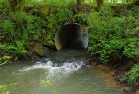
2 Stream Simulation in a Changing Environment Channel Approximating Structures Providing Multiple Species Passage Changing Watershed characteristics Zoning Implications Climate Change Changing Site Characteristics Bank Full Width is dynamic Continuity of flow and sediment Are Stream Simulation Culverts Resilient? Kane Drive, Gresham OR,
3 Methodology Collaborative Culvert performance metrics Chehalis Basin study sites 2D hydrodynamic modeling (Riverflow 2D) 2D mobile bed modeling (Nays2DH) Culvert performance evaluation tool 3
4 The Chehalis River Basin 7,000 km 2 watershed 8 major sub basins 2,700 culvert passage barriers Focus of watershed, flood and species issues Source: USFS National Map Data 4
5 Site Selection Criteria Stream slope Long Profile Skew angle Entrenchment ratio Flood prone width Downstream control Morphological condition < 2% Continuous < 15 o < 3 < 3 x BFW No backwater effect Dynamic stability 5


6 Chehalis Basin Study Site Locations Boyer Road Big Creek Taylor Creek Comfort Creek Lost Creek 6

7 Study Site Characteristics Study Site name Drainage Area (SM) Bankfull width (ft) Upstream D50 (mm) Culvert D50 (mm) Mean precip (in/yr) Q2* (cfs) Q100* (cfs) Big Creek Comfort Creek Boyer Road Taylor Creek Lost Creek * Bankfull discharge (Q 2 ), and 100 year flood discharge (Q 100 ) determined using USGS Stream Stats 7

8 Climate Change Study Site name 2059 % Change in Q bankfull 2099 % Change in Q bankfull 2059 % Change in Q % Change in Q 100 Big Creek Comfort Creek Boyer Road Taylor Creek Lost Creek University of Washington Climate Impacts Group Estimates 8
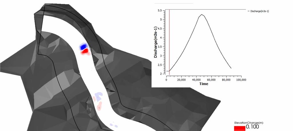
9 Unsteady Hydrology 9
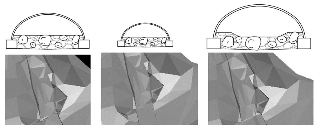
10 Geometries Used for Riverflow 2D Scenario Culvert 0.8BFW with Plane Bed Existing Conditions with Plane Bed BFW with trapezoidal channel 1.2BFW +2 with trapezoidal channel 1.5 BFW with trapezoidal channel No Road fill plane bed Existing Hydrology Big Creek Comfort Creek Boyer Road Taylor Creek Lost Creek Future Hydrology Big Creek Comfort Creek Boyer Road Taylor Creek Lost Creek 10

11 Initial Riverflow 2D Results Shear is a surrogate for sediment transport Culvert width is critical: Too narrow bed shear excessive Too wide energy loss; bed shear insufficient Introduction of substantial benches: Improves continuity of flow, and Appears to improve sediment continuity 11
 software Nays2DH version 2.")
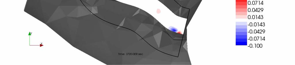
12 Mobile Bed Sediment Transport Model 2D sediment and bed morphology model Comfort Creek site only Q10 24 hr hydrograph: Existing Climate change International River Interface Cooperative (iric) software Nays2DH version 2.3 solver 12
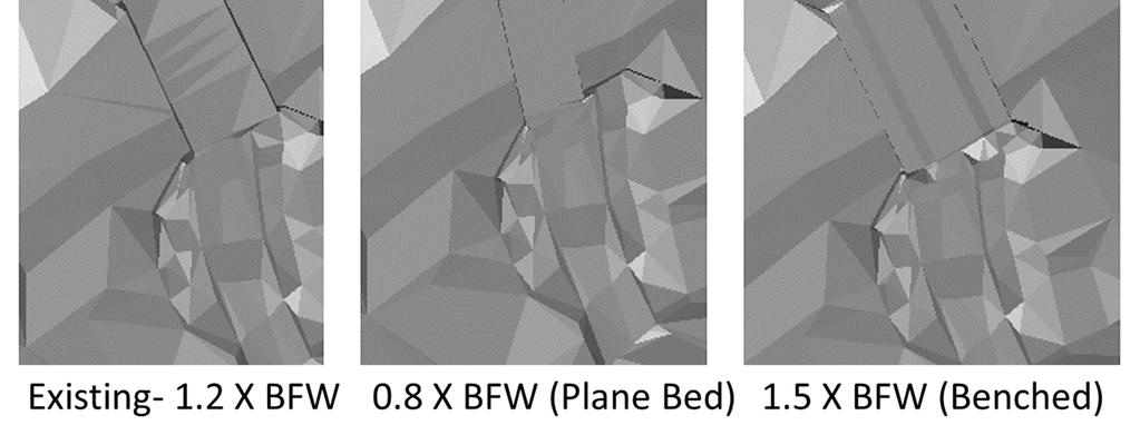
13 Geometries for Nays2DH 13

14 Bed Changes Blue = Scour Red = Deposition Video URL Video URL 0.8 BFW 1.5BFW 14
15 15


16 Climate Change Velocity, mean diameter of the bed and scour increases were tolerable 16

17 Bedload vs. Discharge 17
18 Culvert Performance Metrics Input parameters No. Stream Simulation Metric Stream Value Culvert 1 Average Velocity 2 Headroom 3 Bankfull Width 4 Long stream continuity V stream WSE stream V culvert BFW stream BFW culvert BedElev culvert BedElev stream CrownElev culvert Value 5 Bed Character 6 Bed Mobility Sediment Conectivity and 7 Continuity D50 stream stream Qcrit stream ( Q s / Q) stream D50 culvert culvert Qcrit culvert ( Q s / Q) culvert W culvert 8 Channel Scour (All culverts) BedElev culvert FloorElev culvert FootElev culvert 9 Lateral Dynamics (Long culverts) N wall 18

19 Data Sources Cross section locations: Stream upstream of the culvert Midline of the culvert Input from field data collection and both 2D modeling efforts 19

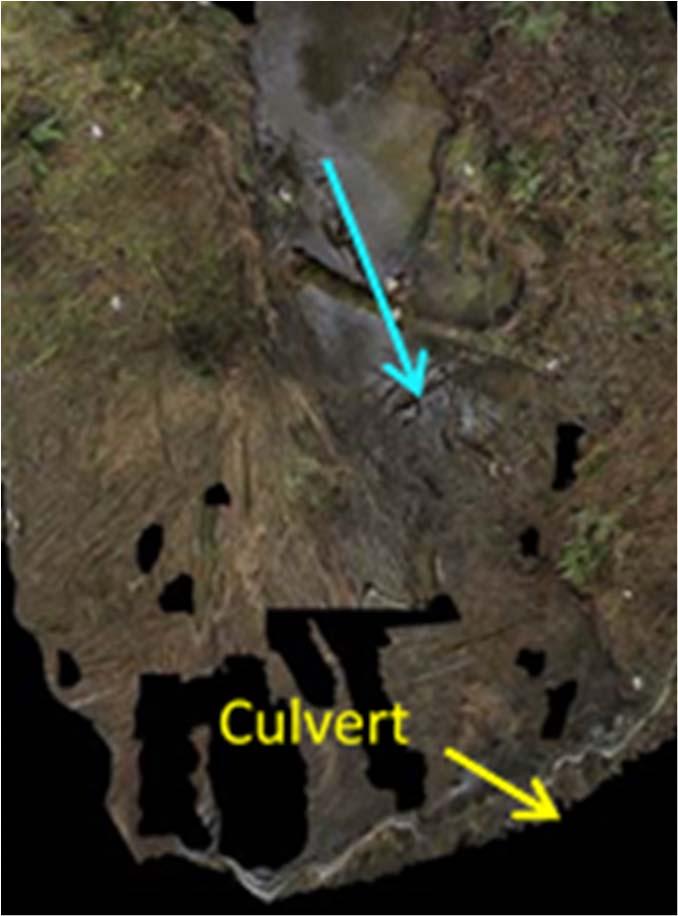
20 Performance Evaluation Tool COMFORT CREEK 1.5 X BFW WITH BENCH FLOW = Q10 HYDROGRAPH MODEL = NAYS2DH 20
21 Conclusions and Recommendations Bankfull benches improve stream simulation performance Culvert width = BFW + stable bench width Skew effect needs further investigation Continue WDFW data collection Develop empirical relationships between performance metrics Utilize performance tool to ensure stream simulation compliance 21
22 Contributors Washington Department of Fish & Wildlife Jane Atha, PhD, Project Manager, Field Data Collection and Conference Presenter (Chapter 2) Kevin Lautz, PE, Field Data Collection and Conference Participant Pad Smith, PE, Field Data Collection and Conference Participant Channing Syms, PE, Conference Participant Timothy Quinn, Conference Participant Environmental Science Associates Colin Thorne, PhD, Conference Presenter, Performance Metrics (Chapters 1, 5, and 6) Joe Richards, PE, Project Manager, Conference Presenter Ryan Bartleheimer, PE, Conference Participant Mason Lacy, EIT, 2D Morphodynamic Modeling Sediment Transport (Chapter 4) Elizabeth Gutierrez, EIT, Reduce Complexity Tool Programming Natural Systems Design Steve Winter, PWS, River Flow 2D Modeling, Conference Presenter (Chapter 3) Garvey Dooley, River Flow 2D Modeling 22


23 Thank You. Questions? Washington Department of Fish & Wildlife 1111 Washington St. SE Olympia, WA Environmental Science Associates 819 SE Morrison, Suite 310 Portland, OR Natural Systems Design 1900 N. Northlake Way, Suite 211 Seattle, WA
Culvert Design for Low and High Gradient Streams in the Midwest. Dale Higgins, Hydrologist Chequamegon-Nicolet National Forest
 Culvert Design for Low and High Gradient Streams in the Midwest Dale Higgins, Hydrologist Chequamegon-Nicolet National Forest Overview Culvert Design Considerations Hydraulic Terms Culvert Impacts Low
Washington State Fish Passage Barrier Removal Projects. Casey Kramer, PE WSDOT State Hydraulics Engineer
 Washington State Fish Passage Barrier Removal Projects Casey Kramer, PE WSDOT State Hydraulics Engineer 2014 National Hydraulic Engineering Conference Iowa City, IA August 20 th, 2014 WSDOT Fish Passage
HEC 26 Aquatic Organism Passage Design Manual Evolution & Application
 HEC 26 Aquatic Organism Passage Design Manual Evolution & Application Sven Leon, P.E., Hydraulics Engineer Federal Highway Administration 2015 Alaska Fish Passage Meeting October 13 14, 2015 VTRC, Juneau,
Joe Rathbun Michigan DEQ Water Resources Division Nonpoint Source Unit * Thanks to The Nature Conservancy
 Joe Rathbun Michigan DEQ Water Resources Division Nonpoint Source Unit rathbunj@mi.gov * Thanks to The Nature Conservancy Road-stream intersections = 67,511 Culverts = 60,700 Bridges = 6,811 Perched Piping
Simulating Streams Through Culverts in Mat-Su, Alaska
 Simulating Streams Through Culverts in Mat-Su, Alaska Project Managers Bill Rice, P.E., USFWS Hydrologist Mary Price, USFWS Fishery Biologist The Team Approach US Fish and Wildlife Service Bill Rice, P.E.,
Hydrologic, Hydraulic and Geomorphic Technical Memorandum
 Appendix A Hydrologic, Hydraulic and Geomorphic Technical Memorandum 01054/8410233/14/Rohner_Alt_Analysis_Report Rohner Creek Flood Control, Habitat and Seismic Improvement Project Alternatives Analysis
CALIFORNIA SALMONID STREAM HABITAT RESTORATION MANUAL APPENDIX IX-A CULVERT CRITERIA FOR FISH PASSAGE INTRODUCTION
 APPENDIX IX-A STATE OF CALIFORNIA RESOURCES AGENCY DEPARTMENT OF FISH AND GAME CULVERT CRITERIA FOR FISH PASSAGE For habitat protection, ecological connectivity should be a goal of stream-road crossing
Exercise (3): Open Channel Flow Rapidly Varied Flow
: Open Channel Flow Rapidly Varied Flow") Exercise (3): Open Channel Flow Rapidly Varied Flow 1) A hydraulic jump exists in a trapezoidal channel having a bed width of 7 m and side slope of 1:1. The flowing discharge is 25 m 3 /sec. Construct
Exercise (3): Open Channel Flow Rapidly Varied Flow 1) A hydraulic jump exists in a trapezoidal channel having a bed width of 7 m and side slope of 1:1. The flowing discharge is 25 m 3 /sec. Construct
Habitat Conditions, Design Strategies,
 Habitat Conditions, Design Strategies, Coho on Cedar Ck. five years after analog-based stream restoration work. and Stream Classification In river work, computer modeling is an insidious procedure in which
OFFICE OF STRUCTURES MANUAL FOR HYDROLOGIC AND HYDRAULIC DESIGN CHAPTER 11 APPENDIX B TIDEROUT 2 USERS MANUAL
 OFFICE OF STRUCTURES MANUAL FOR HYDROLOGIC AND HYDRAULIC DESIGN CHAPTER 11 APPENDIX B TIDEROUT 2 USERS MANUAL APRIL 2011 APRIL 2011 Page 1 Preface TIDEROUT 2, Build 1.22 dated June 29, 2006 is the current
Indiana LTAP Road Scholar Core Course #10 Culvert Drainage. Presented by Thomas T. Burke, Jr., PhD, PE Christopher B. Burke Engineering, Ltd.
 Indiana LTAP Road Scholar Core Course #10 Culvert Drainage Presented by Thomas T. Burke, Jr., PhD, PE Christopher B. Burke Engineering, Ltd. Objectives Review culvert shapes, end sections, and materials
Assessment of Baseline Geomorphic Features at. Proposed Stream Crossings On The Proposed County Road 595. Marquette County, Michigan
 Assessment of Baseline Geomorphic Features at Proposed Stream Crossings On The Proposed County Road 595 Marquette County, Michigan Prepared for: Kennecott Eagle Minerals Company Marquette, Michigan Prepared
Minnesota Department of Natural Resources Division of Fish and Wildlife Section of Fisheries. Stream Survey Report. Three Mile Creek 2011
 Minnesota Department of Natural Resources Division of Fish and Wildlife Section of Fisheries Stream Survey Report Three Mile Creek 2011 By Joseph D. Stewig Montrose Area Fisheries Office TABLE OF CONTENTS
Understanding the Impacts of Culvert Performance on Stream Health
 Understanding the Impacts of Culvert Performance on Stream Health Kristin Thomas Aquatic Ecologist Michigan Trout Unlimited Transportation and the Environment Conference 12/5/2018 Importance of adequately
Aquatic Organism Passage at Road-Stream Crossings CHUCK KEEPORTS FOREST HYDROLOGIST ALLEGHENY NATIONAL FOREST WARREN, PENNSYLVANIA
 Aquatic Organism Passage at Road-Stream Crossings CHUCK KEEPORTS FOREST HYDROLOGIST ALLEGHENY NATIONAL FOREST WARREN, PENNSYLVANIA TOPICS COVERED Aquatic Organism Passage (AOP) Benefits of AOP Crossings
Fish Passage Assessment of Private Stream Crossings on Lower Stonybrook Creek
 Fish Passage Assessment of Private Stream Crossings on Lower Stonybrook Creek Prepared by: Michael Love & Associates In cooperation with: Center for Ecosystem Management and Restoration Funded by: Coastal
Plan B Dam Breach Assessment
 Plan B Dam Breach Assessment Introduction In support of the Local Sponsor permit applications to the states of Minnesota and North Dakota, a dam breach analysis for the Plan B alignment of the Fargo-Moorhead
Discussion on the Selection of the Recommended Fish Passage Design Discharge
 Discussion on the Selection of the Recommended Fish Passage Design Discharge Introduction The provision of fish passage is a requirement for most proposed culvert and bridge installations in Alberta, depending
Presented by Fred Halterman, URS Jennie Agerton, URS
 Presented by Fred Halterman, URS Jennie Agerton, URS What is Eco Friendly Culvert Design? Culvert design that: Maintains connectivity for aquatic organism migration Maintains connectivity for gene flow
Fish Passage Culvert Assessment for Cahilty Creek Watershed FIA Project #
 Fish Passage Culvert Assessment for Cahilty Creek Watershed FIA Project # 4602004 Prepared for Weyerhaeuser Company Ltd. Jason Ladyman R.P.F. 1550 Mission Flats Road PO Box 40 Kamloops BC V2C 5K3 Prepared
WMS 8.4 Tutorial Hydraulics and Floodplain Modeling HY-8 Modeling Wizard Learn how to model a culvert using HY-8 and WMS
 v. 8.4 WMS 8.4 Tutorial Hydraulics and Floodplain Modeling HY-8 Modeling Wizard Learn how to model a culvert using HY-8 and WMS Objectives Define a conceptual schematic of the roadway, invert, and downstream
TREATING RIVERS RIGHT & EXAMPLES OF BEST USE OF WOOD IN RESTORATION
 TREATING RIVERS RIGHT & EXAMPLES OF BEST USE OF WOOD IN RESTORATION James Mac Cartney, TU River Restoration Specialist John Braico, MD, NY Council Resource Mgr Grassroots Trustee 1 Great Trout Streams
Design Report for Janes Creek Roughened Channel
 August 12, 2005 Design Report for Janes Creek Roughened Channel Table of Contents Project Description...1 Overview of Report...1 Background...2 Design Flows...3 Roughened Channel Design...6 Fish Passage
Rock Ramp Design Guidelines. David Mooney MS Chris Holmquist-Johnson MS Drew Baird Ph.D. P.E. Kent Collins P.E.
 Rock Ramp Design Guidelines David Mooney MS Chris Holmquist-Johnson MS Drew Baird Ph.D. P.E. Kent Collins P.E. Rock Ramp Design Guidelines OUTLINE Local and System Interactions with Rock Ramps Ramp Geometry
CALCASIEU SALINITY STRUCTURES. HYDRODYNAMIC MODELING (To Support Design of Salinity Barriers)
") CALCASIEU SALINITY STRUCTURES HYDRODYNAMIC MODELING (To Support Design of Salinity Barriers) Presentation Overview 1 2 3 4 5 Project Overview and CEA Circulation Modeling Vessel Hydrodynamics Modeling
CALCASIEU SALINITY STRUCTURES HYDRODYNAMIC MODELING (To Support Design of Salinity Barriers) Presentation Overview 1 2 3 4 5 Project Overview and CEA Circulation Modeling Vessel Hydrodynamics Modeling
Incorporating Geomorphic Processes and Sediment Dynamics into Salmonid Habitat Restoration Design
 Salmonid Restoration Federation 35 th Annual Salmonid Restoration Conference Davis, CA Incorporating Geomorphic Processes and Sediment Dynamics into Salmonid Habitat Restoration Design Concurrent Session:
APPENDIX J HYDROLOGY AND WATER QUALITY
 APPENDIX J HYDROLOGY AND WATER QUALITY J-1 Technical Report on Airport Drainage, Northern Sector Airport and Ordinance Creek Watershed / Preliminary Creek Constructed Natural Channel Culvert J-2 Preliminary
Illinois State Water Survey
 Illinois State Water Survey HYDROLOGY DIVISION SWS Contract Report 508 COMPARISON OF 1987 AND 1989 BED PROFILE SURVEYS OF THE LOWER CACHE RIVER by Richard Allgire Office of Sediment and Wetland Studies
USING A LABYRINTH WEIR TO INCREASE HYDRAULIC CAPACITY. Dustin Mortensen, P.E. 1 Jake Eckersley, P.E. 1
 USING A LABYRINTH WEIR TO INCREASE HYDRAULIC CAPACITY Dustin Mortensen, P.E. 1 Jake Eckersley, P.E. 1 Plum Creek Floodwater Retarding Structure No. 6 is located in an area of Kyle, Texas, that is currently
Minnesota Department of Natural Resources Division of Fish and Wildlife Section of Fisheries. Stream Survey Report. Luxemburg Creek.
 Minnesota F-29-R(P)-24 Area 315 Study 3 March 2016 Minnesota Department of Natural Resources Division of Fish and Wildlife Section of Fisheries Stream Survey Report Luxemburg Creek 2015 Mark Pelham Sauk
Stream Assessment. Date. Data Collected by. Location. Name of Stream and River Basin. Stream Order. Streambank Materials. Streambank Vegetation
 Stream Assessment Date Data Collected by Location Name of Stream and River Basin Stream Order Streambank Materials Streambank Vegetation Floodplain Soils Floodplain Vegetation Valley Type Valley Constraints
Management of headwater streams in the White Mountain National Forest
 Management of headwater streams in the White Mountain National Forest White Mountain National Forest Weeks Act of 1911 authorized the federal government to purchase lands east of the Mississippi River
SELBY CREEK SILVERADO TRAIL CULVERT FISH PASSAGE ASSESSMENT
 SELBY CREEK SILVERADO TRAIL CULVERT FISH PASSAGE ASSESSMENT NAPA COUNTY, CALIFORNIA PREPARED BY NAPA COUNTY RESOURCE CONSERVATION DISTRICT 1303 JEFFERSON ST. SUITE 500B NAPA, CALIFORNIA 94559 WWW.NAPARCD.ORG
PENNDRAIN.rep. HEC-RAS Version May 2005 U.S. Army Corp of Engineers Hydrologic Engineering Center 609 Second Street Davis, California
 HEC-RAS Version 3.1.3 May 2005 U.S. Army Corp of Engineers Hydrologic Engineering Center 609 Second Street Davis, California X X XXXXXX XXXX XXXX XX XXXX X X X X X X X X X X X X X X X X X X X XXXXXXX XXXX
FINAL REPORT. Yonkers Creek Migration Barrier Removal Project Wonderstump Road Del Norte County. Submitted By:
 FINAL REPORT Yonkers Creek Migration Barrier Removal Project Wonderstump Road Del Norte County Submitted By: Del Norte County Community Development Department Yonkers Creek Migration Barrier Removal Project
Packwood Hydroelectric Project Barrier Analysis December 12, 2006
 Packwood Hydroelectric Project Barrier Analysis December 12, 2006 Study Area Natural barriers to upstream fish passage on Lake Creek at RM 1.03 and RM 1.95 Snyder Creek culvert under the Project tailrace
Rehabilitation of Grimes Creek, a Stream Impacted in the Past by Bucket-lined Dredge Gold Mining, Boise River Drainage, July 2008 to August 2011.
 Rehabilitation of Grimes Creek, a Stream Impacted in the Past by Bucket-lined Dredge Gold Mining, Boise River Drainage, July 2008 to August 2011. Pam Harrington TU,1020 W. Main Street Suite 440, Boise,
APPENDIX A STRUCTURE DESCRIPTIONS AND RATING CURVES
 3 4 5 6 7 8 9 0 3 APPENDIX A STRUCTURE DESCRIPTIONS AND RATING CURVES Kissimmee River Vol December 005 Version Draft 4 3 4 5 6 7 8 9 0 3 4 5 6 7 8 9 0 3 4 5 6 7 8 9 30 3 3 33 34 35 36 37 38 39 40 4 4 43
Fish Passage Design Aids Wildlife Crossing in Washington State State of the Practice
 Fish Passage Design Aids Wildlife Crossing in Washington State State of the Practice 0 Submission date: November, 0 Word Count:, Jon Peterson, corresponding author (0-0-, peterjn@wsdot.wa.gov) Fish Passage
HY-8 Version 7.2 Build Date January 17, Federal Highway Administration.
 HY-8 Version 7.2 Build Date January 17, 2012 Federal Highway Administration http://www.fhwa.dot.gov/engineering/hydraulics/software/hy8/index.cfm SIMPLE Simple to use Use for simple culverts and bridges
Chadbourne Dam Repair and Fish Barrier
 Chadbourne Dam Repair and Fish Barrier Final Report for the Western Native Trout Initiative Prepared by: Carol Endicott Yellowstone Cutthroat Trout Conservation Biologist Montana Fish, Wildlife & Parks
Eastern Brook Trout Joint Venture Annual Report The Nature Conservancy 2013
 Eastern Brook Trout Joint Venture Annual Report The Nature Conservancy 2013 2013 Annual Performance Report Enhancing Connectivity in the Ash-Black Rock Sub-basin of the West Branch Narraguagus River. Project
CHAPTER 4 SPALDING COUNTY, GEORGIA 4.0 CULVERT DESIGN
 SPALDING COUNTY, GEORGIA CHAPTER 4 4.0 CULVERT DESIGN... 4-1 4.1 INTRODUCTION... 4-1 4.2 SYMBOLS AND DEFINITIONS... 4-1 4.3 ENGINEERING DESIGN CRITERIA... 4-2 4.3.1 FREQUENCY FLOOD... 4-2 4.3.2 VELOCITY
Lake Merwin and Swift Creek Reservoir Tributaries. Bull Trout Limiting Factors Analysis
 Lake Merwin and Swift Creek Reservoir Tributaries Bull Trout Limiting Factors Analysis Study Objectives Answer Key? s Do other tributaries to Swift Creek Reservoir and Lake Merwin not known to support
LITTLE LAGOON & LITTLE LAGOON PASS: RESEARCH UPDATES & DIRECTIONS
 LITTLE LAGOON & LITTLE LAGOON PASS: RESEARCH UPDATES & DIRECTIONS Bret M. Webb, PhD, PE, DCE Professor Department of Civil, Coastal, and Environmental Engineering October 19, 2017 LLPS Meeting Acknowledgments
Trout Unlimited Comments on the Scope of Environmental Impact Statement for the Constitution Pipeline Project, Docket No. PF12-9
 October 9, 2012 Kimberly D. Bose, Secretary Federal Energy Regulatory Commission 888 First Street, NE, Room 1A Washington, DC 20426 RE: Trout Unlimited Comments on the Scope of Environmental Impact Statement
MEMO. Schedule 'B' Class Environmental Assessment and Preliminary Design Lakeview Boulevard Improvements Culvert Assessment.
 MEMO Schedule 'B' Class Environmental Assessment and Preliminary Design Lakeview Boulevard Improvements Culvert Assessment February 15, 2017 As per the preferred Lakeview Boulevard alignment provided by
Chapter 11. Culverts and Bridges Design Checklist for Culvert Design
 Yes No N/A Design Requirements I. GENERAL DESIGN GUIDELINES Chapter 11. Culverts and Bridges A. Culvert design is in accordance with the Culverts chapter of Volume 2 of the UDFCD Manual for additional
Unsteady Wave-Driven Circulation Cells Relevant to Rip Currents and Coastal Engineering
 Unsteady Wave-Driven Circulation Cells Relevant to Rip Currents and Coastal Engineering Andrew Kennedy Dept of Civil and Coastal Engineering 365 Weil Hall University of Florida Gainesville, FL 32611 phone:
Massachusetts Stream Crossing Case Studies
 Massachusetts Stream Crossing Case Studies Amy Singler Associate Director, River Restoration Program Carrie Banks River Continuity Coordinator Case Studies: Public Benefits: Movement of goods and people
OFFICE OF STRUCTURES MANUAL FOR HYDROLOGIC AND HYDRAULIC DESIGN CHAPTER 13 CULVERTS APRIL 2011
 OFFICE OF STRUCTURES MANUAL FOR HYDROLOGIC AND HYDRAULIC DESIGN CHAPTER 13 CULVERTS APRIL 2011 APRIL 2011 Chapter 13 Culverts Table of Contents Foreword.3 13.1 Introduction.. 4 13.2 Policy 6 13.3 Passage
Mid-Columbia Fisheries Enhancement Group Annual Report Fiscal Year 06: July 1, 2005 June 30, 2006
 Mid-Columbia Fisheries Enhancement Group Annual Report Fiscal Year 06: July 1, 2005 June 30, 2006 Mission Statement The mission of the Mid-Columbia Fisheries Enhancement Group is to restore self-sustaining
Geomorphic Stream Classification A Classification of Natural Rivers, Rosgen, D.L.
 Geomorphic Stream Classification A Classification of Natural Rivers, Rosgen, D.L. Why is Stream Classification Physical stream channel evolution Essential? Similar stream types manifest similar patterns
Technical Report Culvert A Hydraulic Analysis
 DATE: November 3, 2011 Technical Report Culvert A Hydraulic Analysis TO: FROM: RE: Jim Reiser, P.E. Project Manager Parsons Brinckerhoff, Inc. Kurt Killian, P.E., CFM Parsons Brinckerhoff, Inc. Design
DRAFT. Stonybrook Creek Watershed
 DRAFT Stonybrook Creek Watershed A Strategic Plan for Eliminating Barriers to Steelhead Migration June 4, 2010 Prepared by: PO Box 4477, Arcata, CA 95518 mlove@h2odesigns.com / (707) 476 8938 Prepared
Fish Friendly Crossings- Examples from Nash Stream
 Fish Friendly Crossings- Examples from Nash Stream Maggie Machinist- North Regional Forester, Division of Forests and Lands. Nash Stream Nash Stream Forest is 40,000 acres, owned and managed by NH Division
SUBMERGED VENTURI FLUME. Tom Gill 1 Robert Einhellig 2 ABSTRACT
 SUBMERGED VENTURI FLUME Tom Gill 1 Robert Einhellig 2 ABSTRACT Improvement in canal operating efficiency begins with establishing the ability to measure flow at key points in the delivery system. The lack
Minnesota Department of Natural Resources Division of Fish and Wildlife Section of Fisheries. Stream Survey Report. Cold Spring Creek.
 Minnesota F-29-R(P)-24 Area 315 Study 3 March 2015 Minnesota Department of Natural Resources Division of Fish and Wildlife Section of Fisheries Stream Survey Report Cold Spring Creek 2014 Mark Pelham Montrose
Summary of HEC 18, Evaluating Scour at Bridges FHWA NHI Should really follow HEC 18, but this summary will get you the main points.
 Summary of HEC 18, Evaluating Scour at Bridges FHWA NHI 01-001 Should really follow HEC 18, but this summary will get you the main points. 1: Determine scour analysis variables 2: Analyze long-term bed
Water surface slope extending up to 20 channel widths up and downstream of crossing.
 Site Evaluations Site Information Site Location: Mt ood NF, Forest Road 7 Year Installed: Pre-987 Lat/Long: 8 W Watershed rea (mi ): N Stream Slope (ft/ft) : Channel Type: Step-pool ankfull Width (ft):
Experimental Investigation on Changes of Water Surface Profile with Gaussian Shaped Bottom and Side Roughness
 Experimental Investigation on Changes of Water Surface Profile with Gaussian Shaped Bottom and Side Md. Rafiue Islam a, Shariful Islam b*, Md. Abdul Qaiyum Talukder c, S. M. Rezwan Hossain d Abstract Bed
NUMERICAL AND PHYSICAL MODELING
 POINTE DU BOIS GENERATING STATION SPILLWAY REPLACEMENT PROJECT NUMERICAL AND PHYSICAL MODELING Kara Hurtig, Northwest Hydraulic Consultants, North Vancouver, BC, Canada David S. Brown, KGS Group, Winnipeg,
Five Counties Salmonid Conservation Program - Fish Passage Design Workshop. February 2013
 Program - Aquatic Organisms and Stream Crossings Ecological Connectivity A watershed is a network of channels that drain a common boundary. Channel characteristics formed by interaction of precipitation,
DEADWOOD CREEK FISH PASSAGE IMPROVEMENT PROJECT
 DEADWOOD CREEK FISH PASSAGE IMPROVEMENT PROJECT Coho Salmon in Deadwood Creek Project Area - November 2, 2004 FINAL REPORT National Fish and Wildlife Foundation Project #2002-0368-014 CA Department of
Colusa Basin Drain Watershed Fish Stranding Tour Concept Paper Mike Hendrick and Brycen Swart NMFS
 Colusa Basin Drain Watershed Fish Stranding Tour Concept Paper Mike Hendrick and Brycen Swart NMFS On May 31, 2013 representatives from CDFW, USFWS, and NMFS went on a field tour to look at locations in
Fish Passage at Road Crossings Assessment Boise National Forest FY 2004
 Culvert Inventory Summary 2004 - Boise National Forest Fish Passage at Road Crossings Assessment Boise National Forest FY 2004 Feather River at Road #135 Crossing By Michael S. Kellett, Fishery Biologist
APPENDIX C VEGETATED EMERGENCY SPILLWAY. VERSION 1.0 March 1, 2011
 APPENDIX C VEGETATED EMERGENCY SPILLWAY VERSION 1.0 March 1, 2011 [NOTE: Could use a better photo more clearly showing the emergency spillway in the context of the dam.] SECTION C-1: DESCRIPTION OF PRACTICE
Ellis Y. Byeon, PE Bryan VanderGheynst, PE 1
 Ellis Y. Byeon, PE Bryan VanderGheynst, PE 1 Background Information: City of Trenton, Mercer County Assunpink Creek, Pond Run and Delaware River Lower 2.5 miles of the Assunpink Creek Lower 0.6 miles of
SECTION 2 HYDROLOGY AND FLOW REGIMES
 SECTION 2 HYDROLOGY AND FLOW REGIMES In this section historical streamflow data from permanent USGS gaging stations will be presented and discussed to document long-term flow regime trends within the Cache-Bayou
Modeling of Long Culverts and Stormdrains A Comparison of Different Methods
 Modeling of Long Culverts and Stormdrains A Comparison of Different Methods Shrinivas Kaulgud, P.E., CFM Cheryl Hannan, P.E., CFM, LEED AP October 12, 2017 Presentation Outline Introduction Case Studies
BC Ministry of Forests. March Fish Stream Crossing Guidebook. Forest Practices Code of British Columbia.
 FRST 557 Lecture 7c Bridges and Culverts: Water Velocity and Discharge Lesson Background and Overview: The previous two lessons presented methods for estimating water volume flow at a particular site and
APPENDIX C. Fluvial and Tidal Hydraulics Report
 APPENDIX C Fluvial and Tidal Hydraulics Report BUENA VISTA LAGOON ENHANCEMENT PROJECT FLUVIAL AND TIDAL HYDRAULICS ANALYSES Prepared for: SANDAG 401 B Street, Suite 800 San Diego, California 92101 Contact:
MCCAW REACH RESTORATION
 Final Report MCCAW REACH FISH RESTORATION PHASE B Jack McCaw Inland Empire Action Coalition http://www.wwccd.net/ Phone: 509-956-3777 Hours: 8:00-4:30 Walla Walla County Conservation District Snake River
Fish Habitat Restoration and Monitoring in Southeast Washington. Andy Hill Eco Logical Research, Inc.
 Fish Habitat Restoration and Monitoring in Southeast Washington Andy Hill Eco Logical Research, Inc. Fish Habitat Restoration and Monitoring in Southeast Washington Talk overview: Restoration projects
Stevens Creek Corridor
 O F F I C E O F T H E D I R E C T O R O F P U B L I C W O R K S Stevens Creek Corridor Creek Restoration Project Volume Three Project Update: Creek Photos, Before & After BY GAIL SEEDS - PROJECT MANAGER,
Proposed Reclassification of Muskrat Creek, North Platte River Basin in Goshen County, Wyoming
 Proposed Reclassification of Muskrat Creek, North Platte River Basin in Goshen County, Wyoming October 25, 2010 Waterbody: Muskrat Creek - Mainstem of Muskrat Creek from its headwaters downstream to its
A THESIS M.S. CIVIL ENGINEERING UNIVERSITY OF ALASKA ANCHORAGE ALEXANDRA WEST JEFFERIES, P.E.
 Assessing Fish Passage Success in Culvert Structures with the Development of a Two-Dimensional Algorithm Considering Physical Capabilities of Juvenile Salmonids ALEXANDRA WEST JEFFERIES, P.E. A THESIS
Suitable Applications Check dams may be appropriate in the following situations: To promote sedimentation behind the dam.
 Categories EC Erosion Control SE Sediment Control TC Tracking Control WE Wind Erosion Control Non-Stormwater NS Management Control Waste Management and WM Materials Pollution Control Legend: Primary Category
Redd Dewatering and Juvenile Salmonid Stranding in the Lower Feather River,
 Redd Dewatering and Juvenile Salmonid Stranding in the Lower Feather River, 2005-2006 Interim Report for NOAA Fisheries Prepared by: California Department of Water Resources Division of Environmental Services
P.O. Box 65 Hancock, Michigan USA fax
 This PDF file is a digital version of a chapter in the 2005 GWS Conference Proceedings. Please cite as follows: Harmon, David, ed. 2006. People, Places, and Parks: Proceedings of the 2005 George Wright
Tips for Using & Printing Spreadsheets
 Key to Spreadsheets Spreadsheet # Type Description/Purpose a Development & Construction in Waterways b Debits Development & Construction in Other Aquatic Areas c Indirect Impacts to Waterways from Development
Annex E Bridge Pier Protection Plan
 Annex E Bridge Pier Protection Plan Table E1 Bridge Types and Locations Table E2 Flow Conditions For River Sections Figure E1 Bridge Abutment Protection Figure E2 Bridge Pier Protection Figure E3 Central
CHAPTER 5 CULVERT DESIGN
 CHAPTER 5 CULVERT DESIGN HYDRAULICS OF CULVERTS There are two major types of culvert flow: 1) flow with inlet control, and 2) flow with outlet control. For each type, different factors and formulas are
Culvert Design An Overview of the NYS Highway Design Manual Chapter 8
 Seventeenth Statewide Conference on Local Bridges Culvert Design An Overview of the NYS Highway Design Manual Chapter 8 Tuesday, October 25, 2011 Training Session: Culvert Design, Analysis - talk 2 Presented
Interim Guidance Fish Presence Absence
 Interim Guidance Fish Presence Absence Source: Forest Practices Act Guidance for Division 635 of the forest practices act dealing with stream classification when no fish surveys have been done (referenced
Mountain Columbia Province
 Rolling Provincial Review: Implementation 2001-2003 Province 229 Columbia Basin Fish & Wildlife Authority Province FY 2001-2003 Spending Summaries NPCC Recommendations and BPA Spending by Project Category,
Modeling changes to the historic Lower Columbia River Estuary using Delft3D. Drew Mahedy Lumas Helaire Stefan Talke David Jay May 30, 2014
 Modeling changes to the historic Lower Columbia River Estuary using Delft3D Drew Mahedy Lumas Helaire Stefan Talke David Jay May 30, 2014 Comparison: Historic and Modern LCRE US Coastal Survey, 1868 Historic
Tidal River Management (TRM)-An Innovative Scientific Approach for Sustainable Sediment Management
-An Innovative Scientific Approach for Sustainable Sediment Management") Paper ID: WRE-029 954 International Conference on Recent Innovation in Civil Engineering for Sustainable Development () Department of Civil Engineering DUET - Gazipur, Bangladesh Tidal River Management
Paper ID: WRE-029 954 International Conference on Recent Innovation in Civil Engineering for Sustainable Development () Department of Civil Engineering DUET - Gazipur, Bangladesh Tidal River Management
St. Johns River Water Supply Impact Study (WSIS)
") St. Johns River Water Supply Impact Study (WSIS) Michael G. Cullum, P.E. Chief, Bureau of Engineering & Hydro Science St. Johns River Water Management District The Water Supply Impact study is the most
St. Johns River Water Supply Impact Study (WSIS) Michael G. Cullum, P.E. Chief, Bureau of Engineering & Hydro Science St. Johns River Water Management District The Water Supply Impact study is the most
TROUT CREEK WATERSHED (Second Year of Snowline Data)
") Extent of Snow Cover During the 2002 Spring Freshet For the TROUT CREEK WATERSHED (Second Year of Snowline Data) (Penticton Forest District) 1.0 INTRODUCTION The extent of snow cover over a watershed basin
Extent of Snow Cover During the 2002 Spring Freshet For the TROUT CREEK WATERSHED (Second Year of Snowline Data) (Penticton Forest District) 1.0 INTRODUCTION The extent of snow cover over a watershed basin
4.4 ASSESSMENT OF POTENTIAL ANADROMOUS FISH HABITAT UPSTREAM OF MERWIN DAM (AQU 4)
") 4.4 ASSESSMENT OF POTENTIAL ANADROMOUS FISH HABITAT UPSTREAM OF MERWIN DAM (AQU 4) 4.4.1 Study Objectives The objectives of this study are to: (1) delineate the stream segments in the upper North Fork
4.4 ASSESSMENT OF POTENTIAL ANADROMOUS FISH HABITAT UPSTREAM OF MERWIN DAM (AQU 4) 4.4.1 Study Objectives The objectives of this study are to: (1) delineate the stream segments in the upper North Fork
Minnesota Department of Natural Resources Division of Fish and Wildlife Section of Fisheries. Fairhaven Creek 2000
 Minnesota F-29-R(P)-17 Area 340 Study 3 April 2001 Minnesota Department of Natural Resources Division of Fish and Wildlife Section of Fisheries Stream Survey Report Fairhaven Creek 2000 By Eric R. Altena
Bob Battalio, PE Chief Engineer, ESA September 8, 2016
 RELATING FUTURE COASTAL CONDITIONS TO EXISTING FEMA FLOOD HAZARD MAPS Technical Methods Manual Bob Battalio, PE Chief Engineer, ESA September 8, 2016 FMA 2016 Sacramento, California DWR-OST-SIO PILOTING
MEMORANDUM. TNC Fisher Slough Final Design and Permitting Subject: DRAFT Technical Memorandum: Levee Emergency Spillway Design
 MEMORANUM TNC Fisher Slough Final esign and Permitting Subject: RAFT Technical Memorandum: Levee Emergency Spillway esign To: From: Internal Memorandum For Record Yen Hsu Chen (Tetra Tech) avid Cline (Tetra
Scott Dam Spillway Comparing Physical Model Study Results
 Scott Dam Spillway Comparing Physical Model Study Results Darren Hinton, P.E., Ph.D., Seattle Laboratory Manager, Northwest Hydraulic Consultants, USA Brian Hughes, M.A.Sc., P.E., Principal, Northwest
FISHERIES BLUE MOUNTAINS ADAPTATION PARTNERSHIP
 FISHERIES A warming climate, by itself, substantially affects the hydrology of watersheds in the Blue Mountains. Among the key hydrologic changes projected under all scenarios for the 2040s and beyond
FISH PASSAGE IMPROVEMENT in California s Watersheds. Assessments & Recommendations by the Fish Passage Forum
 FISH PASSAGE IMPROVEMENT in California s Watersheds Assessments & Recommendations by the Fish Passage Forum FISH PASSAGE IMPROVEMENT in California s Watersheds The mission of the Fish Passage Forum is
Emergent Sandbar Habitat Program Middle Missouri River
 Emergent Sandbar Habitat Program Middle Missouri River Jeremiah Szynskie, P.E. Hydrologic Engineering Branch Introduction Main Stem System Dam Closures Fort Peck 1937 Fort Randall 1952 Garrison - 1953
Cross-Vane Plan View FIN-UP Habitat Consultants, Inc. 220 Illinois Avenue Manitou Springs, CO (719) P.
 P.") STREAM CHANNEL STRUCTURE DRAWINGS ISIONS W (Channel Width) (Varies) Thalweg & Flow Direction Individually Placed Footer Rocks 5' to 6' by 2' thick (Min. 2 rows of footer rocks placed tightly together with
STREAM CHANNEL STRUCTURE DRAWINGS ISIONS W (Channel Width) (Varies) Thalweg & Flow Direction Individually Placed Footer Rocks 5' to 6' by 2' thick (Min. 2 rows of footer rocks placed tightly together with
Follow this and additional works at:
 University of Massachusetts Amherst ScholarWorks@UMass Amherst International Conference on Engineering and Ecohydrology for Fish Passage International Conference on Engineering and Ecohydrology for Fish