The warm days of summer are long gone and once again Windsor Lake is frozen, just as it has been every winter for decades.
|
|
|
- Lydia Johnston
- 5 years ago
- Views:
Transcription
1
2
3
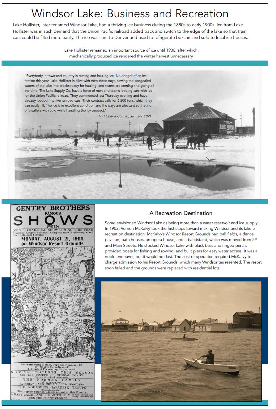
4 Paths to the Present Windsor s Ice Harvest The warm days of summer are long gone and once again Windsor Lake is frozen, just as it has been every winter for decades. The reservoir s water enabled local farmers to irrigate their fields during the summer, but surprisingly once the harvest was over and winter set in, the lake did not cease to contribute to the commerce of the town. In a time when mechanical refrigeration was nonexistent, ice was a precious commodity. Windsor Lake, known as Lake Hollister until 1907, became the site of a plentiful ice business in the early 1880s. By 1886, over 2,000 tons of ice from Lake Hollister was sent to Denver and used to refrigerate railcars for the Union Pacific Railroad. According to the Fort Collins Courier in January 1891; Everybody in town and country is cutting and hauling ice. No danger of an ice famine this year. Lake Hollister is alive with men these days, sawing the congealed waters of the lake into blocks ready for hauling, and teams are coming and going all the time. The Lake Supply Co. have a force of men and teams loading cars with ice for the Union Pacific railroad. They commenced last Thursday evening and have already loaded fifty-five railroad cars. Their contract calls for 6,200 tons, which they can easily fill. The ice is in excellent condition and the days are pleasant so that no one suffers with cold while handling the icy product. Lake Hollister remained an important source of ice until 1900, after which mechanically produced ice rendered the winter harvest unnecessary. Caitlin Heusser is the Museum Curator for the Town of Windsor. Photograph Caption: Ice Harvest on Lake Hollister, circa 1890 Town of Windsor Museum Permanent Collection
5 Town of Windsor Museum Written by Caitlin Heusser, Museum Curator Windsor Lake Windsor Lake has been a central feature of the Windsor community for over 125 years. The lake has been so much more than a water reservoir; it has played an important role in the identity, recreation, and commerce of Windsor. Long before the establishment of Windsor, Windsor Lake was little more than a soggy depressed swath of land used by grazing buffalo as a wallow. With the last buffalo gone from the area in 1864, early pioneers saw the potential for the area and began to change the landscape for farming, irrigation, and homesteading. Edward Hollister, an original Union Colony member, arrived in 1870, to begin homesteading in what would later become Windsor. At the northern most edge of Hollister s property the naturally depressed area held the promise of a water reservoir for the Lake Supply Ditch Company. With funding from local area farmers, the wallow was expanded to become the company s principle water reservoir in the early 1880s. The reservoir became known as Hollister Lake and as the demand for water increased over time with the establishment of farms, the size of Hollister Lake was expanded. Hollister Lake had a thriving ice business during the 1880s to early 1900s. Ice from Windsor Lake was in such demand that the Union Pacific railroad added track and switch to the edge of the lake for train cars to be more easily filled. The ice was sent to Denver and used to refrigerate boxcars and sold to local ice houses. January 1891, the Fort Collins Courier wrote, Everybody in town and country is cutting and hauling ice. No danger of an ice famine this year. Lake Hollister is alive with men these days, sawing the congealed waters of the lake into blocks ready for hauling, and teams are coming and going all the time. The Lake Supply Co. have a force of men and teams loading cars with ice for the Union Pacific railroad. They commenced last Thursday evening and have already loaded fifty-five railroad cars. Their contract calls for 6,200 tons, which they can easily fill. The ice is in excellent condition and the days are pleasant so that no one suffers with cold while handling the icy product. In 1907, the Lake Supply Ditch Company reorganized as the Kern Reservoir and Ditch Company, at this point the lake become officially known as Kern Reservoir, named after local agriculture tycoon Lewis Kern.
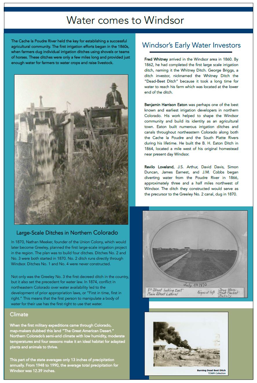
6 Some envisioned the lake as being more than a water reservoir and ice supply. In 1903, Vernon McKalvy took the first steps towards making Windsor and its lake a recreation destination. McKalvy s Windsor Resort Grounds had ball fields, a dance pavilion, bath houses, an opera house, and bandstand which was moved from 5 th and Main Streets. He stocked Windsor Lake with Black bass and Ringed perch, provided boats for fishing and rowing, and built piers for easy water access. It was an adventitious endeavor, but it would not last. The cost of operation required McKalvy to charge admission to his Resort Grounds which many Windsorites resented. The resort soon failed and the grounds were replaced with residential lots. In the years to come Kern s contribution to the area diminished from memory and lake began to be called Windsor Lake. By the 1960s confirmation of the lake s name was established by the United States Geological Survey naming the body of water Windsor Lake. Through the years, Windsor Lake has been dredged and expanded. It has continued to be a source of water for farms and a place of recreation for Windsor residents. From ice harvesting and ice skating during the winter at the turn of century, to boating, fishing, swimming, and sunbathing in the summer, Windsor Lake has been, and continues to be, a central feature of the Windsor community.
7 Paths to the Present Windsor: a recreation paradise of the past It is spring and with the warm weather we find ourselves itching to get outside and recreate. Things were not much different in the past for Windsorites. By 1882, Windsor was a destination for outdoorsman from Denver. Windsor Lake had a plentiful supply of fish for anglers and hunters had ample opportunities to hunt waterfowl. Recreation was taken to a whole new level with the construction of Windsor Park Grounds in Vernon McKelvey, developer and owner of the Grounds, purchased a fleet of small boats for Windsor Lake which could be rented for 25 cents per hour. He stocked the lake with black bass, yellow perch and ringed perch to entice visitors. In addition, a large sports facility was constructed on the eastside shore of the lake and included various ball fields, a bandstand, dance pavilion, and bathhouses. On May 23, 1903, a field meet for northern Colorado high schoolers was held at the complex with great success. The event was intended to be an annual occurrence, but was sparsely attended in the second year and was discontinued in the third year. Windsor Park Grounds failed within a few years due to lack of an income source. Windsor residents did not want to pay to watch and participate in sporting events that they could do at no cost elsewhere, and McKelvey could not entice out-of-town visitors to attend. The land was later platted for residential homes. The area became known as the Park Addition, and homes were built on what were once ball and track fields. Caitlin Heusser is the Museum Curator for the Town of Windsor. Photograph Caption: Boats on Windsor Lake, bandstand visible on the shore in background. Town of Windsor Museum Permanent Collection
8 Climate When the first military expeditions came through Colorado, map-makers dubbed this land The Great American Desert. Northern Colorado s semi-arid climate with low humidity, moderate temperatures and four seasons make it an ideal habitat for adapted plants and animals to thrive. This part of the state averages only 13 inches of precipitation annually. From 1948 to 1990, the average total precipitation for Windsor alone was inches. Water The Cache la Poudre River held the key for establishing a successful agricultural community. The first irrigation efforts began in the 1860s, when farmers dug individual irrigation ditches using shovels or teams of horses. These ditches were only a few miles long and provided just enough water for farmers to water crops and raise livestock. Water comes to Windsor In 1870, Nathan Meeker, founder of the Union Colony which would later become Greeley, planned the first large-scale irrigation project in the region, planning to build four ditches. No. 2 and No. 3 were both started in No. 2 ditch runs directly through Windsor. Ditches No. 1 and No. 4 were never constructed. Not only was the Greeley No. 3 the first decreed ditch in the country, but it also set the precedent for water law. In 1874, conflict in Northeastern Colorado over water availability led to the development of prior appropriate laws, or First in time, first in right. This means that the first person to manipulate a body of water for their use has the first right to use that water. In the 1880s, several years of plentiful rainfall blessed northeastern Colorado with an abnormally wet climate that attracted many potential farmers. Yet by the early 1890s, the arid climate returned leaving many early settlers feeling fooled. Farming could not continue without irrigation, and droughts led to experiments with dry farming which involved conserving moisture in the soil and growing droughtresistant crops such as winter wheat and forage sorghum. The drought of the 1920s and 1930s pushed Colorado State University to develop a device that would more accurately measure water flow. The Great Depression spurred the Colorado-Big Thompson Project which brought water over the mountains from the Western slope. Dry Farming Weld County became one of the best dry farming regions in Colorado and farmers raised corn, melons, squash, onions, cabbage, potatoes, beets, peas and beans. Potatoes and wheat were among the earliest and
9 most successful cash crops grown in Windsor prior to the sugar beet. By 1882, an irrigation system had been developed that provided water to local farms allowing farmers to grow a wider variety of crops. Ranching Stock raising was also an important aspect of northeastern Colorado s agricultural system. Livestock such as sheep and cattle were shipped from Windsor on a daily basis. Benjamin Eaton ( ) Benjamin Harrison Eaton was perhaps one of the best known and earliest irrigation developers in Northern Colorado. His work helped shape the Windsor community and build its identity as an agricultural town. Eaton worked along both the Cache La Poudre and the South Platte Rivers during his lifetime to harness the water, and capitalize on its resources. He built the B. H. Eaton Ditch in 1864 about a mile west of his original homestead near present day Windsor. As a public leader, Eaton was elected the fourth governor of the Colorado Territorial Legislature in 1884, and passed some of Colorado s first water rights laws. Eaton incorporated the Windsor Reservoir and Canal Company in May of 1890, and is also credited with having worked on the High Line Canal, and the Larimer and Weld Canal. Fred Whitney arrived in the late summer of 1860, and was the first to settle in what would later become Windsor. Within two years, Whitney completed the first large scale irrigation ditch naming it the Whitney (Dead-Beat) Ditch. According to Roy Ray, the Whitney Ditch was one of the best ditches along the river, and was the first irrigation ditch built in the Windsor vicinity. George Briggs nicknamed the Whitney Ditch the Dead-Beat Ditch because it took a long time for water to reach his farm which was located at the lower end of the ditch. Lake Supply Ditch Company The Lake Supply Ditch Company was influential in growing not only Lake Hollister as a water storage reservoir, but also in the establishment of Windsor as a town. The company was started by local farmers C.M. McKelvey and L.S. Springer who funded and constructed Lake Hollister making it one of the earliest water reservoirs in Northern Colorado. Together with Edward Hollister, a Union Colony farmer and land owner, they platted the Town of Windsor and worked to draw businesses to the area.
10 Windsor Lake Windsor Lake has been a central feature of the Windsor community for over 125 years. The lake has been so much more than a water reservoir; it has played an important role in the identity, recreation, and commerce of Windsor. Long before the establishment of Windsor, Windsor Lake was little more than a soggy depressed swath of land used by grazing buffalo as a wallow. With the last buffalo gone from the area in 1864, early pioneers saw the potential for the area and began to change the landscape for farming, irrigation, and homesteading. Edward Hollister, an original Union Colony member, arrived in 1870, to begin homesteading in what would later become Windsor. At the northern most edge of Hollister s property the naturally depressed area held the promise of a water reservoir for the Lake Supply Ditch Company. With funding from local area farmers, the wallow was expanded to become the company s principle water reservoir in the early 1880s. The reservoir became known as Hollister Lake and as the demand for water increased over time with the establishment of farms, the size of Hollister Lake was expanded. Hollister Lake had a thriving ice business during the 1880s to early 1900s. Ice from Windsor Lake was in such demand that the Union Pacific railroad added track and switch to the edge of the lake for train cars to be more easily filled. The ice was sent to Denver and used to refrigerate boxcars and sold to local ice houses. January 1891, the Fort Collins Courier wrote, Everybody in town and country is cutting and hauling ice. No danger of an ice famine this year. Lake Hollister is alive with men these days, sawing the congealed waters of the lake into blocks ready for hauling, and teams are coming and going all the time. The Lake Supply Co. have a force of men and teams loading cars with ice for the Union Pacific railroad. They commenced last Thursday evening and have already loaded fifty-five railroad cars. Their contract calls for 6,200 tons, which they can easily fill. The ice is in excellent condition and the days are pleasant so that no one suffers with cold while handling the icy product. In 1907, the Lake Supply Ditch Company reorganized as the Kern Reservoir and Ditch Company, at this point the lake become officially known as Kern Reservoir, named after local agriculture tycoon Lewis Kern. Some envisioned the lake as being more than a water reservoir and ice supply. In 1903, Vernon McKalvy took the first steps towards making Windsor and its lake a recreation destination.
11 McKalvy s Windsor Resort Grounds had ball fields, a dance pavilion, bath houses, an opera house, and bandstand which was moved from 5 th and Main Streets. He stocked Windsor Lake with Black bass and Ringed perch, provided boats for fishing and rowing, and built piers for easy water access. It was an adventitious endeavor, but it would not last. The cost of operation required McKalvy to charge admission to his Resort Grounds which many Windsorites resented. The resort soon failed and the grounds were replaced with residential lots. In the years to come Kern s contribution to the area diminished from memory and lake began to be called Windsor Lake. By the 1960s confirmation of the lake s name was established by the United States Geological Survey naming the body of water Windsor Lake. Through the years, Windsor Lake has been dredged and expanded. It has continued to be a source of water for farms and a place of recreation for Windsor residents. From ice harvesting and ice skating during the winter at the turn of century, to boating, fishing, swimming, and sunbathing in the summer, Windsor Lake has been, and continues to be, a central feature of the Windsor community. Agriculture/Farming: The lands of northeastern Colorado are naturally dry, receiving only 9-11 inches of rainfall a year. In the early days of settlement, farmers had to use new methods of cultivation in the arid climate. Experiments with dry farming involved conserving moisture in the soil and growing drought-resistant crops such as winter wheat used in yeast breads, and sorghum grass for animal feed. Windsor had an irrigation system by 1882 that utilized water from Windsor Lake and the Cache la Poudre River. By the turn of the century, agriculture in Colorado accounted for more jobs than mining. Agricultural growth encouraged industrial growth as factories were needed to process meat and grain. These entrepreneurial efforts required a local railroad for profitable business operations.
12 Agriculture flourished in the Windsor area at the beginning of the 20 th century. An unusually wet season, improvements to the irrigation systems, and a rapidly growing population led to a third of the plains being purchased and plowed for agriculture. When the weather conditions changed, environmental challenges became catalysts for improvements. Why Irrigation? The success of Colorado agriculture is directly linked to our ability to attain water from an unforgiving environment. Northern Colorado only became an agricultural success because of irrigation. Irrigation is necessary in semi-arid climates for agriculture and farming, as regular rainfall cannot be counted on.
Albany County, Wyoming
 Albany County, Wyoming Western Land Sales 123 South 12th Street Thermopolis, WY 82443 www.westernland.net Roy Ready 307-234-2211 J.R. Kvenild 307-259-5000 China Wall Ranch Albany County, WY LOCATION &
North Park Ranch for Sale North Park Ranch for Sale. Double M Ranch Jackson County, CO
 Double M Ranch Jackson County, CO Professionally Developed Trout Fishery and Recreational Ranch Over 2 miles of trophy fishing on the Michigan River One hour from Steamboat Springs Resort Recreational
Americans Move West. Chapter 18 page 582
 Americans Move West Chapter 18 page 582 Miners, Ranchers, and Railroads Chapter 18 Section 1 Page 586 Mining Boom Miners, ranchers, and farmers remade the landscape of the West as they adapted to their
Post- Civil War Western Migrations and the Western Frontier
 Post- Civil War Western Migrations and the Western Frontier America After the Civil War: 1870-1900 Ranching, Mining, & Farming Industrialization & Urbanization Reconstruction & Rise of Jim Crow Segregation
The Ahamacave or Mohave The Mohave continue to live in their river valley homelands The Mohave eat many different types of food dammed
 The Ahamacave or Mohave The information below is taken from The Ahamacave (commonly pronounced as Mohave) Traveling Suitcase exhibit for Museum Education Outreach, Grade Levels 3-4, 5-6 Teacher Manual,
Early History, Prehistory
 History of Management of Large Mammals in North America What experience and history teach us is this that nations and governments have never learned anything from history, or acted upon any of the lessons
Economics of Spice Pepper Production in Oklahoma 1
 Economics of Spice Pepper Production in Oklahoma 1 Raymond Joe Schatzer and Anita M. Kinsella Department of Agricultural Economics James E. Motes and Brian A. Kahn Department of Horticulture and Landscape
Weather, Supply and the Turkish Flour Miller - The Outlook for World Wheat Prices 2018/19
 Weather, Supply and the Turkish Flour Miller - The Outlook for World Wheat Prices 2018/19 v Daniel W Basse President AgResource Chicago, IL January 2016 Daniel W Basse Daniel Basse Daniel President W Basse
MIDDLE FORK RANCH FAIRPLAY, COLORADO PARK COUNTY PRESENTED BY
 MIDDLE FORK RANCH FAIRPLAY, COLORADO PARK COUNTY PRESENTED BY 1 06 OVERVIEW 08 LOCATION 11 FEATURES 13 ATTRACTIONS 14 RANCH HISTORY 17 WILDLIFE 2 3 N MIDDLE FORK RANCH FAIRPLAY, COLORADO 3,338 ACRES PARK
THE NATIVE AMERICANS
 THE NATIVE AMERICANS Native American Diversity By the year 1500, Native Americans had divided into hundreds of cultural groups who perhaps spoke up to 2,000 different languages. Each group adapted to its
South Willow Creek Pasture Musselshell County Roundup, Montana
 South Willow Creek Pasture Musselshell County Roundup, Montana Jeff Klaus Listing Agent 406-855-1081 cell montwyowest@gmail.com PO Box 578 Laurel, MT 59044 Phone: (406) 855-1081 Website: montwyowest.com
HOLT MOUNTAIN RANCH GLENWOOD, NEW MEXICO 74.4 (15.7 IRRIGATED) DEEDED ACRES 15,722 USFS ACRES
 DEEDED ACRES 15,722 USFS ACRES") HOLT MOUNTAIN RANCH GLENWOOD, NEW MEXICO 74.4 (15.7 IRRIGATED) DEEDED ACRES 15,722 USFS ACRES Offered Exclusively By Chas S. Middleton and Son, LLC www.chassmiddleton.com 1507 13th Street Lubbock, Texas
HOLT MOUNTAIN RANCH GLENWOOD, NEW MEXICO 74.4 (15.7 IRRIGATED) DEEDED ACRES 15,722 USFS ACRES Offered Exclusively By Chas S. Middleton and Son, LLC www.chassmiddleton.com 1507 13th Street Lubbock, Texas
The geography of Mapungubwe
 The geography of Mapungubwe Grade 6, Term 1 Social Science: History Lesson Topic: The geography of Mapungubwe Lesson 2 of 8 CAPS reference: page 42 Total time: 1 hour Aims Engage higher order thinking
How did the Cattle Industry Develop Part 2 Solution 3 Set up Ranches on The Plains The Open Range System John Iliff and the beginnings of ranching on
 How did the Cattle Industry Develop Part 2 Solution 3 Set up Ranches on The Plains The Open Range System John Iliff and the beginnings of ranching on the Plains In 1861 John Iliff bought a herd of cattle
FINAL ENVIRONMENTAL IMPACT STATEMENT ON RESIDENT CANADA GOOSE MANAGEMENT Questions and Answers
 FINAL ENVIRONMENTAL IMPACT STATEMENT ON RESIDENT CANADA GOOSE MANAGEMENT Questions and Answers The following document answers some common questions about the issue of overabundant resident Canada goose
Cloverdale Ranch 1, /- Acres Fannin County, Texas $3,997,116 ($2,695/acre) Office: (214)
 Office: (214)") 1,483.16+/- Acres Fannin County, Texas $3,997,116 ($2,695/acre) Office: (214) 361-9191 Fannin County, Texas 1483.16 +/- Acres LOCATION: Historic Cloverdale Ranch is located in northwest Fannin County with
1,483.16+/- Acres Fannin County, Texas $3,997,116 ($2,695/acre) Office: (214) 361-9191 Fannin County, Texas 1483.16 +/- Acres LOCATION: Historic Cloverdale Ranch is located in northwest Fannin County with
Creating America (Survey)
") Creating America (Survey) Chapter 19: Growth in the West, 1860-1900 Section 1: Miners, Ranchers, and Cowhands Main Idea: Miners, ranchers, and cowhands settled in the West seeking economic opportunities.
Creating America (Survey) Chapter 19: Growth in the West, 1860-1900 Section 1: Miners, Ranchers, and Cowhands Main Idea: Miners, ranchers, and cowhands settled in the West seeking economic opportunities.
Kingston is a critical component of maritime commerce in the Hudson River Valley and the state of New York because
 Thesis-Lauren Project Logo-LaurenLauren Place-Lauren Brief History of Kingston -Allie Natural Ice Industry-Allie Rondout Creek: Lighthouses -Maryellen Rondout Creek: Industries -Maryellen Fishing-Maryellen
Ranchers create ponds, wetlands in Owyhee County in partnership with U.S. Fish and Wildlife Service
 Ranchers create ponds, wetlands in Owyhee County in partnership with U.S. Fish and Wildlife Service By Steve Stuebner In the arid West, water is key to the survival of everything. That's why early-day
Growth in the West
 Growth in the West 1860-1900 The Great Plains The Great Plains had few trees, but its grasslands were home to more than 300,000 Native Americans in the mid-1800 s. Most followed the buffalo herds that
(Short Listing) SUN RIVER RANCH, VAUGHN, MONTANA
 SUN RIVER RANCH, VAUGHN, MONTANA") (Short Listing) SUN RIVER RANCH, VAUGHN, MONTANA The Sun River Ranch is, without question a premiere property situated in the scenic Sun River Valley among the mature Cottonwood trees along the Sun River
(Short Listing) SUN RIVER RANCH, VAUGHN, MONTANA The Sun River Ranch is, without question a premiere property situated in the scenic Sun River Valley among the mature Cottonwood trees along the Sun River
Toward an Outlook for California Agriculture Relevant to GHG Emissions Mitigation. April 30, Daniel A. Sumner
 Toward an Outlook for California Agriculture Relevant to GHG Emissions Mitigation April 30, 2013 Daniel A. Sumner University of California Agricultural Issues Center and UC Davis, Agricultural and Resource
List of Sites & Activities
 List of Sites & Activities Pg. 1 Live Eagle Nest Cam Pg. 2 Fort Vasquez Pg. 3 Missile Site Park Pg. 4 Denver Zoo Pg. 5 Greeley Independence Stampede Pg. 6 Colorado Model Railroad Museum Pg. 7 Wild Animal
Ely, Nevada Highway Commercial Office/Warehouse/Industrial Property
 Ely, Nevada Highway Commercial Office/Warehouse/Industrial Property 6,000 + SF Office/Warehouse has 2 half baths, office, and roll up doors on the east and west walls 5.81 acre parcel fronts Highway 93
California Agriculture and Global Challenges: Resources Prices and Prospects 2012 California Ag Summit January 27, 2012
 California Agriculture and Global Challenges: Resources Prices and Prospects 2012 California Ag Summit uary 27, 2012 Daniel A. Sumner University of California Agricultural Issues Center Outline and Main
GREAT PLAINS MOUNTAINS AND BASINS NORTH CENTRAL PLAINS COASTAL PLAINS
 GREAT PLAINS MOUNTAINS AND BASINS NORTH CENTRAL PLAINS COASTAL PLAINS MOUNTAINS AND BASINS Landform- different features on the surface of the earth Desert-A dry, often sandy region with little rainfall,
18,000 +/- ACRE KNOX COUNTY, TEXAS RANCH BENJAMIN, TEXAS
 18,000 +/- ACRE KNOX COUNTY, TEXAS RANCH BENJAMIN, TEXAS LOCATION: Approximately 90 miles southwest of Wichita Falls. The southern ranch boundary adjoins the City of Benjamin. The western ranch boundary
Circle W Ranch SPRAY, OREGON. Hunting Ranching Fly Fishing Conservation
 Circle W Ranch SPRAY, OREGON Hunting Ranching Fly Fishing Conservation Circle W Ranch SPRAY, OREGON CIntroduction The Circle W Ranch is located in North Central Oregon. The North border of the ranch runs
Lake Chapman North Narrative
 Lake Chapman North Narrative The Marshes Jack and Bonnie Marsh relocated to Lake Chapman in the late 1970's from the Carrollwood area. They moved particularly for the lake property with the aim to give
The week of October, 6 th Serving People, Managing Wildlife
 The week of October, 6 th 2014 Wildlife Division Serving People, Managing Wildlife! Resident only Pheasant season runs October 11 th October 13 th.! Regular Pheasant season starts October 18 th and runs
Utah Studies. Utah s Native Americans
 Bellringer: D10 Describe what a wiki-up is: P.S. Don t forget about your research project, on an aspect of the Desert Gatherers! This is due T1D11, along with a short presentation. Utah Studies Utah s
Important Flashcard. just click to get the definitions! Chief Joseph
 Important Flashcard just click to get the definitions! Chief Joseph Leader of the Nez Perce tribe who resisted the government in relocating his tribe on a reservation Dawes Act 1887 act which divided Indian
Narrows West. Lots For Sale Overview
 Lots For Sale Overview Spring/Summer Sales Book 2017 My family has been living at the Lake Manitoba Narrows for approximately 100 years. One of my grandfathers settled on the west shore of the Narrows
Weather of the Promised Land
 Biblical Geography Basics NT110 LESSON 10 of 10 Jack Beck, Ph.D. Experience: Author and faculty member at Jerusalem University College in Israel Introduction There s geography in my Bible. Remember, we
PThe 16,000 acre Pettyjohn Ranch is located on the west side of Tehama County twenty miles from Red Bluff, CA on Interstate
 PThe 16,000 acre Pettyjohn Ranch is located on the west side of Tehama County twenty miles from Red Bluff, CA on Interstate 5. It is surrounded by privately owned land and can be reached all year by paved
SUN RIVER RANCH Vaughn, Montana
 SUN RIVER RANCH Vaughn, Montana CLICK HERE FOR A PRINTER-FRIENDLY PDF LOCATION: The Sun River Ranch is located seven miles west of Vaughn, Montana, off Highway 89 in the Sun River Valley. Great Falls,
Deer and Deer Management in Central New York: Local Residents Interests and Concerns
 Deer and Deer Management in Central New York: Local Residents Interests and Concerns NYS Department of Environmental Conservation Division of Fish, Wildlife & Marine Resources and the Human Dimensions
Commodity Market Outlook: Corn, Forage, Wheat & Cattle
 Commodity Market Outlook: Corn, Forage, Wheat & Cattle Stephen R. Koontz Professor & extension economist Department of Agricultural & Resource Economics Colorado State University Stephen.Koontz@ColoState.Edu
Page 1 of 10
 Routt County, Colorado Properties For Sale: Trout Creek Lodge -1075 Deeded Acres List Price / per acre: $5,200,000 $4,837 Trout Creek Lodge and Ranch is the gem of the Trout Creek Valley, located along
January, same manner that stirring a fire hastens its burning.
 January, 1932 9 Checking Gully Erosion on Golf Courses By R. E. Uhland Superintendent, Soil Erosion Experiment Station, Bethany, Mo. No one will deny that good greens and fairways are essential to a good
NEVADA DEPARTMENT OF WILDLIFE STATEWIDE FISHERIES MANAGEMENT
 NEVADA DEPARTMENT OF WILDLIFE STATEWIDE FISHERIES MANAGEMENT FEDERAL AID JOB PROGRESS REPORTS F-20-50 2014 BILK CREEK RESERVOIR WESTERN REGION 1 NEVADA DEPARTMENT OF WILDLIFE, FISHERIES DIVISION JOB PROGRESS
Quagga Mussel Update Lake Powell
 Utah Wildlife News August 14, 2008 Mark Hadley, Editor In this issue: Quagga mussel update Dove hunt preview Catching fish when it s hot Special upland game hunts Quagga Mussel Update Lake Powell Biologist
GREAT PLAINS MOUNTAINS AND BASINS NORTH CENTRAL PLAINS COASTAL PLAINS
 GREAT PLAINS MOUNTAINS AND BASINS NORTH CENTRAL PLAINS COASTAL PLAINS MOUNTAINS AND BASINS Landform- different features on the surface of the earth Desert-A dry, often sandy region with little rainfall,
MCREYNOLDS HOMESTEAD. Bozeman, MT $3.9M 520 Acres. (406)
") MCREYNOLDS HOMESTEAD Bozeman, MT $3.9M 520 Acres (406) 589-4160 MCREYNOLDS HOMESTEAD County: Gallatin Location: Bozeman, MT Price: $3.9M The Old Place parcel of the McReynolds Ranch was home to the family
MCREYNOLDS HOMESTEAD Bozeman, MT $3.9M 520 Acres (406) 589-4160 MCREYNOLDS HOMESTEAD County: Gallatin Location: Bozeman, MT Price: $3.9M The Old Place parcel of the McReynolds Ranch was home to the family
PAYETTE RIVERVIEW PIVOTS
 Two productive center-pivot hay fields overlooking the beautiful Payette River, Horseshoe Bend, Idaho EXECUTIVE SUMMARY The Payette Riverview Pivots are two, productive hay fields irrigated by Zimmatic
FARMER-EXPO. Debrecen, August 2015
 FARMER-EXPO Debrecen, 19-22 August 2015 Debrecen is the second largest city in Hungary, and the traditional economic and cultural centre of its region. It s location - close to the eastern border - makes
Agriculture and the Economy: A View from the Chicago Fed
 Agriculture and the Economy: A View from the Chicago Fed March 3, 2016 Riverside, Iowa David Oppedahl Senior Business Economist 312-322-6122 david.oppedahl@chi.frb.org Federal Reserve System Twelve District
Hooray for Barnegat Bay!
 Hooray for Barnegat Bay! Subject Areas: Science, Social Studies Setting: Classroom Duration: One class period Skills: critical thinking, discussing, listing, comparing, listening, interviewing Vocabulary:
Maggie s. Activity Pack! The Nomad s Home. Daybreak on the Steppe. The Land of Nomads
 Maggie s Activity Pack! Name Date The Nomad s Home Daybreak on the Steppe The hot sun rises on the vast, dry grasslands of Central Asia. It lights up the bright orange-colored door of a Mongolian herder
AMERICAN HISTORY CHAPTER 8 SETTLING OF THE WEST
 AMERICAN HISTORY CHAPTER 8 SETTLING OF THE WEST BOARD QUESTIONS 1) WHAT IS PLACER MINING? 2) WHAT IS QUARTZ MINING? 3) WHAT WAS THE COMSTOCK LODE? 4) WHAT COLORADO TOWN BECAME A LEGENDARY BOOMTOWN? 5)
Arkansas River Hunting Ranch 1,500 Acres Pueblo County, Colorado $3,000,000
 Arkansas River Hunting Ranch 1,500 Acres Pueblo County, Colorado $3,000,000 Presented By: Farm, Ranch & Recreational Real Estate Arkansas River Hunting Ranch 1,500 Acres Pueblo County, Colorado $3,000,000
Debrecen has its own airport so you can check and hu to get information. flights.
 Debrecen is the second largest city in Hungary and is the intellectual, economical, educational and cultural centre of the rthern-plain Region. The second biggest university of the country can be found
Nolan Doesken. Colorado Climate Center.
 Nolan Doesken Colorado Climate Center Presented to: Colorado Conservation Tillage Association, Greeley, CO, February 1-2, 1 2005 http://ccc.atmos.colostate.edu Prepared by Odie Bliss 1 Key Features of
Hunt ID:5094-CO-S-C ElkMDeerAntelope-AI2GCR-R1N-LV2INME-Great Semi-guided
 .. Hunt ID:5094-CO-S-C-2000-003-ElkMDeerAntelope-AI2GCR-R1N-LV2INME-Great Semi-guided Welcome to where the hills meet the plains, where antelope are everywhere, even during antelope season. Where the mule
SELBY RANCH CALIFORNIA, YUBA COUNTY, BROWNS VALLEY. Recreational Haven in Northern California with Excellent Fishing and Hunting
 SELBY RANCH CALIFORNIA, YUBA COUNTY, BROWNS VALLEY Recreational Haven in Northern California with Excellent Fishing and Hunting This beautiful 1,812-acre ranch is located in the Gold Country Foothills
Pigs Gun Club INTERMOUNTAIN REALTY GROUP. A Family Hunting Haven
 Pigs Gun Club A Family Hunting Haven Sanpete County, Utah 554 Acres $1,448,000 INTERMOUNTAIN REALTY GROUP 4543 S Holladay Blvd., Salt Lake City, Utah, 84117 801-277-0800 www.intermountainrealtygroup.com
SOUTH PLATTE RIVER DEER HERD MANAGEMENT PLAN
 SOUTH PLATTE RIVER DEER HERD MANAGEMENT PLAN DATA ANALYSIS UNIT D-44 Game Management Units 91, 92, 94, 96, & 951 March 2009 Marty Stratman Colorado Division of Wildlife Terrestrial Biologist 122 E. Edison
Agricultural Outlook: Rebalancing U.S. Agriculture
 Agricultural Outlook: Rebalancing U.S. Agriculture Michael J. Swanson Ph.D. Agricultural Economist January 2018 2018 Wells Fargo Bank, N.A. All rights reserved. For public use. The U.S. Ag Sector renormalizes!
Image courtesy of NASA/GSFC
 Image courtesy of NASA/GSFC Impact of Weather Extremes and Climate Change on Midwest Agriculture Eugene S. Takle Professor Department of Agronomy Department of Geological and Atmospheric Science Director,
Charolais. Origin-The Charolaise originated in west-central to. Use-They produce excellent quality beef and often are.
 Charolais Origin-The Charolaise originated in west-central to southeastern France. Use-They produce excellent quality beef and often are used to improve herds of other cattle breeds. Charolais tend to
City of Galena 2017 Deer Hunting Survey
 City of Galena 2017 Deer Hunting Survey The City of Galena is collecting information from private property owners about hunting whitetail deer. The survey is intended for owners of agricultural property
Chapter 4: Google Earth Exercise
 Chapter 4: Google Earth Exercise Exercise 1 Visualizing the Three Gorges Dam Hydroelectric Project The Three Gorges Dam was the largest infrastructure project in China since the Great Wall. Completed in
ARIKAREE DEER HERD MANAGEMENT PLAN
 ARIKAREE DEER HERD MANAGEMENT PLAN DATA ANALYSIS UNIT D-55 Game Management Units 101 & 102 January 2006 Marty Stratman Colorado Division of Wildlife Terrestrial Biologist 122 E. Edison St. Brush, CO 80723
Reservoir Ranch Dillon, Montana
 Reservoir Ranch Dillon, Montana Clifton M. Berglee, D.V.M. (Listing Broker) 406-860-7319 cell cberglee@montwyowest.com Phone: (406) 628-2341 (office) Website: montwyowest.com P.O. Box 578, Laurel, Montana
Profiles IN CONSERVATION. Keeping in Harmony with Family Legacy Delaware landowner develops diversion crops for deer
 United States Department of Agriculture Profiles IN CONSERVATION Keeping in Harmony with Family Legacy Delaware landowner develops diversion crops for deer By Glenn Rosenholm Technically speaking, a forest
BULL PIT RANCH GLENBURN, CALIF.
 BULL PIT RANCH GLENBURN, CALIF. OFFERED BY SHASTA LAND SERVICES INC. BILL QUINN LAWRENCE RANCH LOCATION: The Bull Pit Ranch is located on the Upper Fall River off of Island Road. The ranch is in Fall River
Alberta Conservation Association 2016/17 Project Summary Report. Primary ACA staff on project: Stefanie Fenson, Jeff Forsyth and Jon Van Dijk
 Alberta Conservation Association 2016/17 Project Summary Report Project Name: Recreational Opportunity Enhancement Land Management Program Manager: Darren Dorge Project Leader: Stefanie Fenson Primary
colorado.edu/business/brd
 colorado.edu/business/brd Big Changes, Unknown Impacts Southwest Business Forum Place cover image here Richard Wobbekind Senior Economist and Associate Dean for Business and Government Relations January
miller ranch Borden/DawsonCounties,TX 15,920.5Acres,MoreorLes
 miller ranch Borden/DawsonCounties,TX 15,920.5Acres,MoreorLes 150713thStreet Lubbock,Texas79401 Phone(806)763-5331 Fax(806)763-1340 Web-www.chasmiddleton.com E-Mail-sam_middleton@chasmiddleton.com We are
SKINNER MEADOWS RANCH
 SKINNER MEADOWS RANCH JACKSON, MONTANA $3,999,000 I 885+/- ACRES LISTING AGENT: KEITH HANDLOS 10 WEST REEDER STREET DILLON, MT 59725 P: 406.683.2234 M:406.925.1814 KHANDLOS@BEAVERHEADHOMEANDRANCH.COM EXECUTIVE
DMU 452 Northern Multi-County Deer Management Unit
 DMU 452 Northern Multi-County Deer Management Unit Area Description The Core TB Zone Deer Management Unit is in the Northern Lower Peninsula Region (NLP) and covers portions of Alcona, Alpena, Montmorency,
Cowboys, Cattle Drives, and Kansas. Seventh M-20
 Cowboys, Cattle Drives, and Kansas Read Kansas! Seventh M-20 Overview In this lesson students will learn the reasons for the cattle drives in post-civil War Kansas. Students will read a series of historic
People, of course, are the most important.
 Abe Balzer founded Balzer, Inc. in Mountain Lake, Minnesota during the late 1940 s. Being a farmer himself, he intimately understood the needs and challenges of farmers. He had an engineering mind and
f Agricultural S c i e n c SMALL EARTH DAMS LLOYD N. BROWN ^ CALIFORNIA AGRICULTURAL CIRCULAR 467 \ Experiment Station Extension Service
 f Agricultural S c i e n c SMALL EARTH DAMS LLOYD N. BROWN ^ CALIFORNIA AGRICULTURAL \ Experiment Station Extension Service CIRCULAR 467 Crest of dam Dry face slope 2 to 1 Downstream toe About 10,000 small
California Agriculture 2001: Trends and Issues
 California Agriculture 2001: Trends and Issues Daniel A. Sumner Professor, Department of Agricultural and Resource Economics, UC Davis Director, University of California Agricultural Issues Center The
Profiles Of Survey Maps 45/D7 and 45/D10
 Profiles Of Survey Maps 45/D7 and 45/D10 PROFILE OF SURVEY MAP 45 D/7DESCRIPTION of the Area covered by Survey Sheet No. 45 D/7 (Gujarat and Rajasthan) District : Banas Kantha and Sirohi Location: Latitude
NORTH TABLELANDS DEER HERD MANAGEMENT PLAN
 NORTH TABLELANDS DEER HERD MANAGEMENT PLAN DATA ANALYSIS UNIT D-5 Game Management Units 87, 88, 89, 90, & 95 November 2007 Marty Stratman Colorado Division of Wildlife Terrestrial Biologist 122 E. Edison
American Indian Heritage Month
 American Indian Heritage Month Both Governor Gary Herbert and President Barack Obama have issued declarations announcing November to be observed as American Indian Heritage Month. American Indian Heritage
Quemahoning Reservoir
 Pennsylvania Fish & Boat Commission Biologist Report Quemahoning Reservoir Somerset County May 2011 Trap Net, Gill Net and Electrofishing Survey Quemahoning Reservoir is an 899 acre impoundment located
Carpenter Real Estate Presents:
 Carpenter Real Estate Presents: The El Paseo de San Antonio Ranch is your opportunity to own one of the finest and most renowned cattle ranches in the Highlands and Davis Mountains of Texas. The ranch
Franklin County Ranch Hunting, Fishing, Recreation, Cattle Hardwoods, Lakes, Ponds, Waterfowl Habitat, Pastures
 Franklin County Ranch Hunting, Fishing, Recreation, Cattle Hardwoods, Lakes, Ponds, Waterfowl Habitat, Pastures +/- 4,335 Contiguous Acres Janet G. Helm Ranch Broker P.O. Box 399 Van Horn, TX 79855 915-828-3532
Taming the Wild Aurochs
 Taming the Wild Aurochs Objective Students will read about and research the domestication of animals. Students will create a timeline of the domestication of animals. Background All domesticated animals
SCIENTIFIC ADVISER. In support of shooting on Welsh public land
 SCIENTIFIC ADVISER In support of shooting on Welsh public land Well-being of Future Generations Act Among the requirements of this Act 1 are the expectations that public bodies need to account for the
BRENT N. LONNER, Montana Fish, Wildlife & Parks, Fish & Wildlife Division, PO Box 488, Fairfield, MT 59436, USA
 History of Bighorn Sheep in the Sun River Area, Montana BRENT N. LONNER, Montana Fish, Wildlife & Parks, Fish & Wildlife Division, PO Box 488, Fairfield, MT 59436, USA Abstract: The Sun River bighorn sheep
Ranches Of Colorado By John Fielder, James Meadow
 Ranches Of Colorado By John Fielder, James Meadow Contemporary Ranches of Texas - Page 106 - Google Books Result - most significant ranches in the world. Descendants of the founder still control the ranch
YOUNG FARM & SPORTING CLUB A Premium Recreational Investment Property & Hunting Paradise
 YOUNG FARM & SPORTING CLUB A Premium Recreational Investment Property & Hunting Paradise 1,350.0 (+/-) total acres Lonoke County, Arkansas Acreage documented by Lonoke County Ownership Final acreage to
Geography and the Early Settlement of China
 Chapter 19 Geography and the Early Settlement of China How did geograptiy affect life in ancient China? Chapter 19 Geography and the Early Settlement of China How did geograptiy affect life in ancient
MCDERMITT, NEVADA OREGON-NEVADA BORDER
 ZIMMERMAN RANCH MCDERMITT, NEVADA OREGON-NEVADA BORDER The Zimmerman Ranch is located approximately 15 air miles directly west of the community of McDermitt, Nevada. The ranch straddles the Nevada Oregon
Perry 300 Hunting & Lodge
 Perry 300 Hunting & Lodge Perry, FL Taylor County All Offers Considered! Main Lodge Abundant White Tail Deer Cattle Ranching Outdoor Recreation Corporate Retreat Timber Income Parcel ID Numbers: 31-06-09-09245-500
FOR SALE th Avenue Greeley, CO
 FOR SALE 1221 9th Avenue Greeley, CO FOR SALE 1221 9th Avenue Greeley, CO OPERATING BED AND BREAKFAST IN CENTRAL GREELEY PROPERTY TYPE OFFICE/SPECIAL USE AVAILABLE 7,289 SF PRICE $995,000 FEATURES: Successful,
Bigger, Better, Faster: The Changing Nation
 Bigger, Better, Faster: The Changing Nation Railroad building grew from 35,000 miles in 1865 to nearly 200,000 miles by 1897. People began to settle west. Fourteen new states were created. Cowboys and
ARkAnsAs tennessee Primary Partner: Primary Partner: Habitat Work: Habitat Work:
 Eastern Elk initiative david STEPhENSON Elk in the East On foggy mornings when the chill of fall is in the air, distant elk bugles ring sparsely through the hills and valleys of the East. Each one tells
Page 1. USDA s Mandatory Farm Programs CBO s January 2019 Baseline
 USDA s Mandatory Farm Programs CBO s January 2019 Baseline Page 1 The federal Commodity Credit Corporation (CCC) accounts for a significant portion of mandatory federal spending for agriculture through
Modern US History Ch. 18, Section 2 Wars for the West
 Modern US History Ch. 18, Section 2 Wars for the West Settlers Encounter the Plains Indians As settlers moved into the Great Plains the US government sent agents to negotiate treaties with the Plains Indians
Francis Ranch. The Historic. Laramie County one the finest ranches in southeastern Wyoming.
 The Historic Francis Ranch Laramie A working cow-calf or County, yearling operation located Wyoming the southwestern portion of Laramie County one the finest ranches in southeastern Wyoming. Experienced
Large Feral Herbivore (LFH) Management Plan
 Management Plan") Large Feral Herbivore (LFH) Management Plan 2014-2019 Table of Contents 1 Introduction... 3 2 Background... Error! Bookmark not defined. 3 Mission Statement... 3 4 Sub-Regions... 6 4.1 Nullarbor... 6 4.2
Large Feral Herbivore (LFH) Management Plan 2014-2019 Table of Contents 1 Introduction... 3 2 Background... Error! Bookmark not defined. 3 Mission Statement... 3 4 Sub-Regions... 6 4.1 Nullarbor... 6 4.2
US287 Asset Inventory Fort Collins. Figure 5-1 Fort Collins Bridges and Traffic Signals
 Chapter 5: City of Fort Collins US287 through Fort Collins is known as College Avenue, runs for approximately 9.25 miles, and bisects the City north to south. Within the City, US287 is a principal arterial.
Chapter 25 Section 1. Section 3. Objectives
 Objectives Explain the development of the New South. Understand the impact on Native Americans as settlers moved to the West. Identify who moved to the West and their reasons for doing so. Terms and People
NEVADA DEPARTMENT OF WILDLIFE STATEWIDE FISHERIES MANAGEMENT
 NEVADA DEPARTMENT OF WILDLIFE STATEWIDE FISHERIES MANAGEMENT FEDERAL AID JOB PROGRESS REPORTS F-20-48 2012 RYE PATCH RESERVOIR WESTERN REGION NEVADA DEPARTMENT OF WILDLIFE, FISHERIES DIVISION JOB PROGRESS
Native Americans? Who are the. The Bering Strait. Activities Pack 8/7/2015
 Native Americans Activities Pack Who are the Native Americans? They likely came to North America across the Bering Strait when hunting animals. Can you tell where you live on the map? The Bering Strait