COURSE MEASUREMENT SUMMARY SHEET
|
|
|
- Pearl Davis
- 5 years ago
- Views:
Transcription
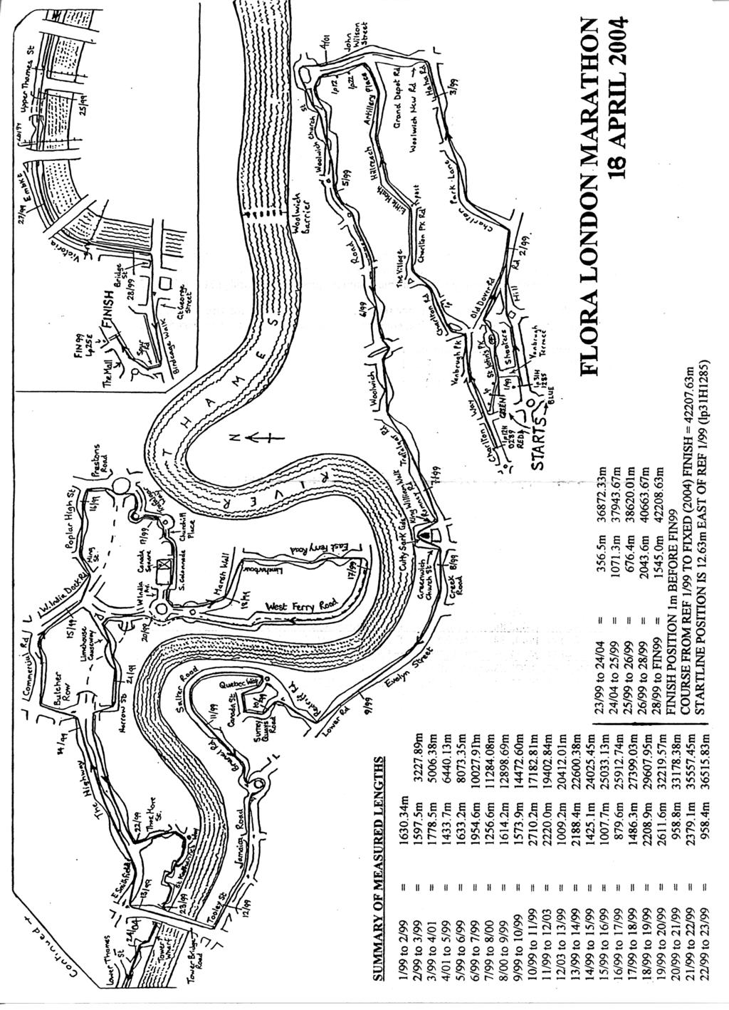
1 CERT NO. 04/ COURSE MEASUREMENT SUMMARY SHEET EVENT THE FLORA LONDON MARATHON LOCATION: LONDON DATE: 18 APRIL 2004 Promoting Organisation: LONDON MARATHON LTD. Name & Address of David Bedford race director 115 Southwark Street London SE1 0FY Tel: Distance: not less than 42,195m Measured by: Pete Riegel & Hugh Jones Dates: & (taping) (Red/Green start additions) , (amendments) Measurement method: Jones counter mounted on bicycle wheel Elevation, if not same, of: START 40.5m FINISH 6.8m Distance, in a straight line, between start & finish: m Description of the Course i) Terrain: mainly flat, but 32m drop in fifth km ii) Race surface tarmac city streets, 400m cobbled section at km iii) Course configuration: point-to-point, incl. complete lap from km Measurement Details i) Section of road available: entire width of road or carriageway (see map) ii) Line to be taken at turns: shortest route (in direction indicated at roundabouts) SIGNED:. DATE:
2 FLORA LONDON MARATHON BLACKHEATH-WESTMINSTER, UK 18 APRIL 2004 The 1999 base measurement has been amended in several minor ways in this report for the 2004 race. Construction at Canary Wharf and at Westminster tube station has previously altered the route in these two places in the intervening years, and the course has also changed, very recently, at the West Gate of thetower of London at 23 miles. Changed positions of traffic islands has altered the turn into East Smithfield just before halfway. The basic course-length measurement is supplemented by two sets of amendments to yield a 2004 course length. Specifically, from 1999 the route has changed to include: i) going the long way around Rotherhithe roundabout (clockwise) and changed kerblines adds 84.88m ii) changed disposition of traffic islands at end of Tower Bridge Road (subtracts 12.35m) iii) use of the full width of Prestons Road Roundabout subtracts 0.57m vi) a re-aligned roadway between Cartier Circle and Canada Square subtracts 48.10m v) changed configuration at west gate of Tower of London subtracts 17.14m v) staying on the south carriageway of Embankment until the junction with Bridge St. adds 6.72m This report also details the measurement of the separate routes from the Red and Green starts to their respective merge points with the main (Blue, elite field) route, done in 2001, and unchanged since. reading counts distance adjusted dist. (m) location m Shooters Hill Road, lp31h m Shooters Hill Road lp113d1285, after Marlboro La m HaHa Road, lp after Repository Road (LHS) m John Wilson Street, lp9 (RHS, after St Mary s St.) m (This reference now lp9aa0781, +1.1m further TF) m Woolwich Road, sign M23/M24 on central divider m Woolwich Rd, lp4b o/s E Greenwich Fire Station m Romney Road, lp10, after Park Street m Creek Road, between Tel kiosks now removed m (new ref: TF of drain, +1.55m further TF) m Evelyn Street, lp18, after Grinstead Street m Surrey Quays Road, lp0468/36, RHS before Canada Street m Salter Road, pillar box LHS, after bridge over dock RE-MEASURED SECTION [calibration constant = /m.] m Salter Road, pillar box LHS, after bridge over dock m Brunel Road, lp252/11 (RHS, before Rupack St) m apex of divider at end of Jamaica Rd } reverse in mea m apex of divider at end of Jamaica Road } suring direction m Tooley Street, lp171 (RHS) after zebra m Tooley Street, lp171 (RHS) after zebra m end of Tower Bridge east parapet_ RE-MEASURED SECTION [calibration constant = /m] m end of Tower Bridge east parapet m the Highway, lph16 (LHS, past Virginia St) m The Highway, TF wall of Ratcliffe Orchard footpath m The Highway, TF wall of Ratcliffe Orchard footpath m Centre of elec.box o/s Limehouse Police Station m Poplar High Street, lp53/22 RHS before Harrow Lane RE-MEASURED SECTION [calibration constant = /m.] m Poplar High Street, lp53/22 RHS before Harrow Lane m Trafalgar Way, steel groove at start of Bridge m Trafalgar Way, steel groove at start of bridge m divider at end of Churchill Place N before obstruction + 8.8m taped (between paint marks either side of temporary obstruction) m divider at west end of Churchill Place m Marsh Wall, lpmi0142 o/s Britannia Hotel m Marsh Wall, lpmi0142 o/s Britannia Hotel m W Ferry Road, between tel.kiosks o/s fire station
3 m TS of drain at exit from W Ferry Circus m Narrow Street, centre of doors to Papermill Wharf m The Highway, lpe1805 before Thomas More St m End inset brick double yellow line, at gate under Tower Br Taped distance from wooden threshold under Tower Bridge (end inset brick double yellow line) to west gate of Tower OUT (HJ, with 0.3m offset) 49.9m x m m = m BACK (PR, with 0.3m offset) = m - agreed taped length = 356.5m RE-MEASURED SECTION [calibration constant = /m.] m west gate of Tower m TF stoplight, after Southwark Bridge m TF Stoplight, after Southwark Bridge m end divider, under Blackfriars railway bridge m Embankment, start of last gap in divider RE-MEASURED SECTION [calibration constant = /m.] m Embankment, start of last gap in divider m Birdcage Walk, lp62e (RHS, before crossing) m Birdcage Walk, lpg91 (RHS, before Spur Rd) m FIXED FINISH LINE POSITION m The Mall lp25e, LHS after Marlborough Road Distance elapsed at finish line from start reference lp31h1285 = m; therefore start line is located 12.63m east of this lamp-post. List of split mile positions START (0.0m) Shooters Hill Road, 12.63m west of lp31h1285 (LHS) 1 mile ( m) Shooters Hill Road, 8.96m before lp113d1285, after Marlboro La (LHS) 2 miles ( m) HaHa Road, 3.43m after lp after Repository Road (LHS) 3 miles ( m) John Wilson St, 6.80m past lp19aa0781 (14.5m before new u/n lp) 5km (5000m) John Wilson Street, 6.25m past lp9aa0781 (RHS, 5.2m before new lp). 4 miles ( m) Woolwich Rd (LHS), 9.88m past sign M23/M24 on central divider 5 miles ( m) Woolwich Rd (RHS), 14m before lp4b o/s E Greenwich Fire Station 6 miles ( m) Trafalgar Rd (RHS) 12.1m past lp10l1416, o/s The Arches pool 10km (10000m) Romney Road (LHS), 15.28m before lp10, TF Park Row 7 miles ( m) Creek Road, 6.44m before TF side of drain before Copperas St 8miles ( m) Evelyn Street (LHS), 11.30m before lp18, TF Grinstead Street 9 miles ( m) Surrey Quays Rd (RHS), 24.13m after lp0468/36, RHS TS Canada Street 15km (15000m) Quebec Way, 5.08m before lp403/06 (LHS) 10 miles ( m) Salter Road (LHS), 20.12m before TS kerb of Russia Dock Road 11 miles ( m) Brunel Road (RHS), 6.11m before lp252/11, just before Rupack St 12 miles ( m) Tooley St, 78.08m before lp171 (RHS, after zebra) or 16.74m past l308/04 20km (20000m) m before end Tower Bridge E parapet (29m before centre of Bridge) 13 miles ( m) The Highway (N carr.), m before lph16 (LHS), 7.2m past lph10 halfway ( m) The Highway (N carr.), 46.06m past lph16 (LHS) 14 miles ( m) The Highway 56.93m before TF wall, Ratcliffe Orchard (11.7m past lph62) 15 miles ( m) W.India Dock Rd (N carr.), 24.86m after lpw50/23 (RHS, on median) 25km (25000m) Poplar High Street, 20.50m before lp53/22 (RHS) TS Harrow Lane 16 miles ( m) Trafalgar Way, 85.53m before anemometer on pole (RHS) 17 miles ( m) Marsh Wall (RHS), 27.55m before lpmi0142 o/s Britannia Hotel 18 miles ( m) E Ferry Rd (LHS), 16.60m past lpe04/23, or 3m before end of wall (RHS) 30km (30000m) W Ferry Rd, 15.15m before lpw45/53, RHS, o/s Pizza & Kebab takeaway 19 miles ( m) W Ferry Rd, 16.26m before TS kerb Crews St (LHS), 10m before lpw45/36 20 miles ( m) 20.06m before TS of drain at exit from W Ferry Circus 21 miles ( m) The Highway (S carr.) 9.97m before lph62 (RHS) 35km (35000m) The Highway (S carr.) 17.56m before lph45 (94m past Chigwell Hill) 22 miles ( m) The Highway (LHS), 13.03m before lph55 TS Vaughan Way 23 miles ( m) Lower Thames St (LHS), 18.71m before TS kerb of Water Lane 24 miles ( m) 16.80m after end divider, under Blackfriars railway bridge
4 40km (40000m) Victoria Embkt, 122m past Cleopatra s Needle, at new lp before toilets 25 miles ( m) Victoria Embankment (LHS), 22.44m after lp28 (past Nth land Ave, RHS) [and 10.56m before new lp opposite entrance to Embankment Gds South] 800m to go (41395m) Birdcage Walk (RHS), 1.79m before lp62e (RHS, before crossing) 400m to go (41795m) Not marked, but 3.27m before lpg91 on Birdcage Walk, before Spur Road 26 miles ( m) Spur Road, 44.67m past lpg91 on Birdcage Walk FINISH ( m) The Mall, 1m before lp25e (RHS) Movement of splits since 2003 race: 0 25km marks are: 13.22m forward 16 mile mark is: 17.84m back 17 mile 22mile marks are: 17.14m back 23 miles km marks are unchanged RED ROUTE reading counts distance adj. distance location m Red start reference lp12h0289 on Charlton Way m Charlton Road, lp before Furzefield Rd (RHS) m Little Heath, post on traffic is after Cemetery La m John Wilson Steet, lp22 (LHS) before Castile Road m John Wilson Street, lp12 (LHS) after Kingman St m Woolwich Road, sign M23/M24 on central divider* *At this point on the blue route m has elapsed, so the adjustment to the red route should be +2.58m. The Red start is therefore 2.58m west of lamp-post12h0289 on Charlton Way Splits on Red route: 1 mile Charlton Road, 19.53m past un-numbered lp before corner of Furzefield Rd (RHS) 2 miles Little Heath, 1.99m past post on traffic is after Cemetery La, o/s Maryon Wilson Park 3 miles John Wilson Street, 8.56m before lp22 (LHS, before Castile Road) & 2.1m past new lp 5km John Wilson Street, 6.25m before lp12 (LHS, after Kingman St) & 7.03m before new lp GREEN ROUTE reading counts distance adj. distance location m Green start reference middle lamp-post along footpath m Shooters Hill Road lp113d1285, after Marlboro La* * At this point on the Blue route m has elapsed, so the adjustment to the green route should be m. The Green start is therefore 12.86m west of the middle lamp post on the footpath (west of St John s Park).
5 CALIBRATIONS Basic Measurement: On 400m steel-taped calibration course on Charlton Way, Pre-measurement, 03.30, 7C Post-measurement, 08.10, 9C start end reading start end reading Average: (x 2.5, x 1.001) Average (x 2.5, x 1.001) Working Constant: /m Finish Constant: /m Constant for the Day (Average) = /m Amendments of main route: On 500m steel-taped calibration course on Rotten Row cycle path, Hyde Park, Pre-measurement, Post-measurement, start end reading start end reading Average (x 2, x 1.001) Average (x 2, x 1.001) Working Constant /m Finish Constant /m Constant for the Day (Average) /m (All amending measurements completed by 08.00) On 500m steel-taped calibration course on Rotten Row cycle path, Hyde Park, Pre-measurement, Post-measurement, start end reading start end reading Average (x 2, x 1.001) Average (x 2, x 1.001) Working Constant /m Finish Constant /m Constant for the Day (larger) /m Pre-measurement, , Post-measurement, , On 400m steel-taped cal.course on E Ferry Rd On 500m steel-taped cal course on Rotten Row Start end reading start end reading Average (x 1.001,/400) Average (x 1.001/500) Working constant = /m Finish constant = /m Costant for the Day (larger) = /m Measurement of Red and Green routes: On 400m EDM-measured calibration course on Bower Ave, Greenwich Park, Pre-measurement, 08.25, 11C Post-measurement, 09.45, 12C start end reading start end reading Average (x 2.5, x 1.001) Average (x 2.5, x 1.001) Working Constant /m Finish Constant /m Constant for the Day (larger) /m
6 SUMMARY OF MEASURED LENGTHS 1/99 to 2/99 = m 2/99 to 3/99 = m m 3/99 to 4/01 = m m 4/01 to 5/99 = m m 5/99 to 6/99 = m m 6/99 to 7/99 = m m 7/99 to 8/00 = m m 8/00 to 9/99 = m m 9/99 to 10/99 = m m 10/99 to 11/99 = m m 11/99 to 12/03 = m m 12/03 to 13/99 = m m 13/99 to 14/99 = m m 14/99 to 15/99 = m m 15/99 to 16/99 = m m 16/99 to 17/99 = 879.6m m 17/99 to 18/99 = m m 18/99 to 19/99 = m m 19/99 to 20/99 = m m 20/99 to 21/99 = 958.8m m 21/99 to 22/99 = m m 22/99 to 23/99 = 958.4m m 23/99 to 24/04 = 356.5m m 24/04 to 25/99 = m m 25/99 to 26/99 = 676.4m m 26/99 to 28/99 = m m 28/99 to FIN99 = m m FINISH POSITION 1m BEFORE FIN99 COURSE FROM REF 1/99 TO FIXED (2004) FINISH = m STARTLINE POSITION IS 12.63m EAST OF REF 1/99 (lp31h1285)
7
8
SUNDAY 4 MARCH 2018 ROAD CLOSURE INFORMATION
 SUNDAY 4 MARCH 2018 CLOSURE INFORMATION HALF MARATHON & FREE FESTIVAL thebighalf.co.uk/road-closures OfficialBigHalf @OfficialBigHalf @OfficialBigHalf THE BIG HALF IS A BRAND NEW ONE DAY FESTIVAL ON SUNDAY
go team parkinson s! Cheering at the Virgin Money London Marathon Sunday 22 April 2018
 go team parkinson s! Cheering at the Virgin Money London Marathon Sunday 22 April 2018 Virgin Money London Marathon 2018 Parkinson s UK Supporters Guide Thank you for supporting our team in this year s
The Mall caibration Course Taping
 The Mall caibration Course Taping Raw tape results for The Mall Calibration Course David 6 *50m lengths plus 28.645 m 328.645 Hugh 6 *50m lengths plus 28.648 m 328.648 Average 328.6465 m m m Assume David
Map and Directions. Walking to raise funds for North London Hospice #bigfunwalk
 Map and Directions Walking to raise funds for North London Hospice 020 8446 2288 www.bigfunwalk.co.uk #bigfunwalk BFW_MAP_2018.indd 1 22/04/2018 21:32 START The Blue Line is the regular route and the Red
Cycle Superhighway 4 from Tower Bridge to Greenwich
 Cycle Superhighway 4 from Tower Bridge to Greenwich About Sustrans Sustrans is the charity making it easier for people to walk and cycle. We are engineers and educators, experts and advocates. We connect
Age UK Virgin Money London Marathon Guide 2019
 Age UK Virgin Money London Marathon Guide 2019 Contents Page 3 Page 4 Page 4 Page 6 Page 8 Page 11 Marathon Expo Age UK Pasta Party Marathon morning Spectators and cheering points Cheering point maps Post-race
ULTIMATE SPECTATORS GUIDE TO THE LONDON MARATHON
 ULTIMATE SPECTATORS GUIDE TO THE LONDON MARATHON We recommend you purchase a Travelcard to travel around London on the day as this will allow access to Rail, Tube and Bus at no extra charge. Zones 1-2
Tiberias Marathon Measurement. Stephen Jackson November
 Tiberias Marathon Measurement Stephen Jackson 14-16 November 2002 sjackson@bigpond.net.au Overview The Tiberias International Marathon has been run for 25 years and incorporates the Israeli national championships.
Hit The Road 2018 Frog and Toad
 Hit The Road 2018 Frog and Toad Meet at Mile End Park. See joining instructions for more details. Sign in so that we know you are there. Chat with friends who you haven t seen since last year and OFF WE
Teenage Cancer Trust s Ultimate Spectators Guide to the London Marathon!
 Teenage Cancer Trust s Ultimate Spectators Guide to the London Marathon! We recommend you purchase a Travelcard to travel around London on the day as this will allow access to Rail, Tube and Bus at no
Cycle Superhighway CS4 Tower Bridge to Greenwich. 7 November
 Cycle Superhighway CS4 Tower Bridge to Greenwich 7 November 2017 https://consultations.tfl.gov.uk/roads/cs4/ This consultation response is on behalf of the London Cycling Campaign, the capital s leading
Cliveden Cross Country Sunday 7 January 2018, 9.00am Under UK Athletics Rules SEAA Race Permit
 Cliveden Cross Country Sunday 7 January 2018, 9.00am Under UK Athletics Rules SEAA Race Permit 2018 31623 Welcome to another post-christmas test of endurance and fitness at Cliveden presented by kind permission
The Mendip Way. Route Directions and Maps Wells to Frome
 The Mendip Way Route Directions and Maps Wells to Frome Website: www.mendiphillsaonb.org.uk Email: mendip@mendiphillsaonb.org.uk Facebook & Twitter: @MendipHillsAONB Phone: 01761462338 1 Wells to Shepton
Signs. signs, signals and road markings. in this chapter
 3 signs, signals and road markings in this chapter Signs regulatory signs school, playground and crosswalk signs lane use signs turn control signs parking signs reserved lane signs warning signs object
The Year Of Mercy Pilgrimage Sts Peter and Paul s Church, Bulimba To The Cathedral of St Stephen
 The Year Of Mercy Pilgrimage Sts Peter and Paul s Church, Bulimba To The Cathedral of St Stephen Dist Route Photos Photos 0.0km St Peter and Paul s Church, 235 Riding Rd & Cnr Main Ave, Balmoral. http://www.bulimbacatholic.com/
VIRGIN MONEY LONDON MARATHON CHEER STATION GUIDE SUNDAY 22 APRIL 2018
 VIRGIN MONEY LONDON MARATHON CHEER STATION GUIDE SUNDAY 22 APRIL 2018 OUR RUNNING CHAMPIONS Having support on the day makes such a huge difference and we simply cannot do it without you and your family
Age UK Virgin Money London Marathon Guide 2018
 Age UK Virgin Money London Marathon Guide 2018 Age UK is a charitable company limited by guarantee and registered in England and Wales (registered charity number 1128267 and registered company number 6825798).
Figure 3B-1. Examples of Two-Lane, Two-Way Marking Applications
 Figure 3B-1. Examples of Two-Lane, Two-Way Marking Applications A - Typical two-lane, two-way marking with passing permitted in both directions B - Typical two-lane, two-way marking with no-passing zones
LONDON BUSES - ROUTE DESCRIPTION
 LONDON BUSES - ROUTE DESCRIPTION Printed On: 17 June 2013 09:32:47 ROUTE 177: Thamesmead, Town Centre - Peckham Bus Station Date of Structural Change: 6 September 2012. Date of Service Change: 1 June 2013.
Ready, Set, Go. Period under security lockdown 25th June 10th September 27th July 12th August 20th August 9th September
 Ready, Set, Go Pallet Track Guide to Logistics During London 2012 Period under security lockdown 25th June 10th September 27th July 12th August 20th August 9th September CONTENTS Introduction 1 Olympic
CHECKLIST 2: PRELIMINARY DESIGN STAGE AUDIT
 CHECKLIST 2: PRELIMINARY DESIGN STAGE AUDIT 2.1 General topics 2.1.1 Changes since previous audit Do the conditions for which the scheme was originally designed still apply? (for example, no changes to
ROAD CLOSURE INFORMATION
 PRL MEDIA GUIDE 2015 GETTING AROUND ROAD CLOSURE INFORMATION To ensure the safety of participants and spectators at the Prudential RideLondon cycling festival, there will be early morning road closures
I was collected from my hotel at 1400 by the Course Manager, Edwin Attard.
 7 tth European Veterans Athletic Non-Stadia Championships Mallta 28/29 Apriill 2001 Course Measurement Report For the 2500 m Lap used for the 20 Km Women s Wallk & the 30 Km Men s Wallk By Miichaell Sandford
The Hundred Parishes
 The Hundred Parishes Walks from railway stations number 9 6.4 miles (10kms) from Bishop s Stortford to Stansted Mountfitchet Start: Bishop s Stortford station (Grid Reference TL492209) (ample parking and
Schedule. Monday 2 nd April. Sign On: Race Start: Team Car Parking. Post Race: Race results: Prize Presentation:
 STAGE 4 ROADBOOK KERRY GROUP RÁS MUMHAN 2018 Schedule Monday 2 nd April. Sign On: Sign-On in Killorglin Sports & Leisure Centre from 8:30 a.m. to 9:30a.m. Race Start: Riders will depart the Killorglin
Road Markings. Lecture Notes in Transportation Systems Engineering. Prof. Tom V. Mathew
 Road Markings Lecture Notes in Transportation Systems Engineering Prof. Tom V. Mathew 1 Overview The essential purpose of road markings is to guide and control traffic on a highway. They supplement the
10 SHERFORD Town Code
 Key Fixes (Ref: Masterplan Book, section 4a. Land Use Budget and Key Fixes ) The Town Plan designs and allocates buildings, streets and spaces as accurately as possible in the understandable absence of
Shepherdswell - Dover
 Shepherdswell - Dover The North Downs Way > Shepherdswell to Dover Introduction This part of the path is slightly different in character from most other parts of the path since it spends much of the time
Chapter 4 Cyclo-cross
 Chapter 4 Cyclo-cross 110 4. Cyclo-cross Racing 4A. Course and obstacles 4A1. The course shall be held over varying terrain including roads, country or forest paths, and open terrain alternating in such
Presented By: Jim Roth, P.E. Signing Engineer Office of Traffic Engineering Ohio Department of Transportation 1980 West Broad Street Columbus, Ohio
 1 Presented By: Jim Roth, P.E. Signing Engineer Office of Traffic Engineering Ohio Department of Transportation 1980 West Broad Street Columbus, Ohio 43223 (614) 752-0438 Fax: (614) 644-8199 jim.roth@dot.state.oh.us
Report from Embassy Visit to Copenhagen May David Arditti
 Report from Embassy Visit to Copenhagen May 2013 David Arditti Standard CPH cycle track, one-way 1.5 2m wide, 5cm above carriageway, 5cm below footway Basic one-way cycle track protected by car parking
Route: Skewsby Foulrice Stearsby
 Route: Skewsby Foulrice Stearsby Distance: 7 miles Map: Explorer: 300 Howardian Hills & Malton Start (OS ref): SE625710 Park in the village of Skewsby. Walk east out of the village to the T-Junction and
Walk 3 - Woodbridge and Melton A Walk Round Waldringfield by Sue and Jim Stacey. Woodbridge. shopping centre, cafes, toilets etc. tide mill.
 Walk 3 - Woodbridge and Melton A Walk Round Waldringfield by Sue and Jim Stacey. road with roundabout church railway with station walk route showing description direction track, wide path, bridlepath footpath
Introduction Methodology Study area and data collection Results and recommendation Conclusion References
 Introduction Methodology Study area and data collection Results and recommendation Conclusion References It is formal procedure for assessing accident potential and safety performance in the provision
MAPS & WALK NOTES. DAY 2: Greenwich Wharf to Woolwich Wharf
 MAPS & WALK NOTES DAY 2: Greenwich Wharf to Woolwich Wharf Total Distance: 15.5km Time: Approximately 5 hours 30 mins five Sections Walk Notes in Section Name Length Time 2:1 Greenwich Wharf to Northwood
CYCLING TIME TRIALS The national governing body for CYCLING time trials
 CYCLING TIME TRIALS The national governing body for CYCLING time trials www.ctt.org.uk SOUTH DISTRICT COUNCIL COURSE DETAILS FOR START SHEETS & RISK ASSESSMENT INDEX Guidance Notes for Event Promoters
Multilane Roundabouts
 Multilane Roundabouts Supplement to Synchro 7 Studio Users Guide Discussion SimTraffic 7 has been updated to better model multilane roundabouts. With the new logic it is possible to model a two-lane arterial
2016 Hertfordshire Triathlon Spring Sunday 28 th August
 Dear Race Entrant, Race Details This is your race information pack for the Hertfordshire Triathlon Spring and the Hertfordshire Triathlon Club Champs. ActiveTrainingWorld would like to thank Moveology,
Muizenberg Accessibility: Removing barriers to public spaces.
 Muizenberg Accessibility: Removing barriers to public spaces. Refer to SANS 10400-S:2011 Edition 3 of the building code. Note: Facilities that are not in accordance with the requirements of this part of
This will bring you out onto Trafalgar Square. Trafalgar Square is normally buzzing with activity.on your right is the National Gallery, and outside
 A Walk past sites of Central London, starting from Charring Cross and ending at London Bridge Station Take the train from Tonbridge to Charring Cross. This will take about 40 mins. As you exit the station
Derby Cycling Group, c/o 126, Station road, Mickleover, Derby, DE3 9FN. Date: 20 th November, 2018.
 Your Ref: Derby City Council Air Quality - Preferred Option Nov 2018 Derby Cycling Group, c/o 126, Station road, Mickleover, Derby, DE3 9FN Date: 20 th November, 2018. 1. Introduction: 1.1. Derby Cycling
2015 Hertfordshire Triathlon Summer Sunday 30 th August
 Dear Race Entrant, Race Details This is your race information pack for the Hertfordshire Triathlon Summer and the Hetfordshire Triathlon Club Champs. ActiveTrainingWorld would like to thank Triathlon Zone,
Intersection Safety 6/7/2015 INTERSECTIONS. Five basic elements should be considered in intersection design. Intersection Safety (continued)
") Intersection Safety S. M. SOHEL MAHMUD Assistant Professor Accident Research Institute (ARI), Bangladesh University of Engineering and Technology (BUET) Dhaka-1000, Bangladesh 1 Outline of the Presentation
Intersection Safety S. M. SOHEL MAHMUD Assistant Professor Accident Research Institute (ARI), Bangladesh University of Engineering and Technology (BUET) Dhaka-1000, Bangladesh 1 Outline of the Presentation
Chapter 4 Route Window C3 Hyde Park and Park Lane shafts. Transport for London
 Chapter 4 Route Window C3 Hyde Park and Park Lane shafts Transport for London HYDE PARK AND PARK LANE SHAFTS 4 Route Window C3 Hyde Park and Park Lane shafts Introduction 4.1 In this route window, which
Key operating rules relating to all Brisbane Ranks
 Brisbane Rank Sites Key operating rules relating to all Brisbane Ranks Only ride on BCC/private landholder approved routes of travel Riding in shared use zones In pedestrian zones where riding is permitted:
LOCAL CIRCUIT EM1: EAST MALLING & BARMING HEATH. N 2m ROADS: Significant roads PATHS: Starting direction Barming Longsole Mission Church
 Ditton Church Scott Close LOCAL CIRCUIT EM1: EAST MALLING & BARMING HEATH 6 Community Centre F Open fields (see 'Introductory Notes') 1m 88 Direction label (as in the walk notes) East Malling Church -
Commonwealth Heads of Government Meeting: London 2018
 Commonwealth Heads of Government Meeting: London 2018 Resident and Business Factsheet Location: The Royal Parks, the Commonwealth Village and the QEII Centre Impact dates: Saturday 14 to Sunday 22 April
Wheelchair Basketball
 Maps 0 UK competition venues Wheelchair Basketball M Competition venue Training venue Hotel Enfield Airport Core Route etwork (PR) Venue Route etwork (PR) Routes to venues Barnet M Weymouth and Portland
SLOUGH Stage 3 Road Safety Audit of A4 London Road, M4 J5 to Sutton Lane
 SLOUGH Stage 3 Road Safety Audit of A4 London Road, M4 J5 to Sutton Lane Exception Report Client Officer Rudo Beremauro Date 20 January 2015 RSA /Project Sponsor s Contents Section 3 Project Sponsor's
How To Read Road Signs - Roundabouts
 How To Read Road Signs - Roundabouts Table of Contents Introduction... 2 Roundabouts... 3 The roundabout is the main road... 3 The terminology used... 4 Left... 4 Ahead... 5 Right... 5 The possible exceptions...
LONDON BUSES - ROUTE DESCRIPTION
 LONDON BUSES - ROUTE DESCRIPTION Printed On: 27 May 2016 14:35:29 ROUTE 159: Streatham Station - Marble Arch (24 hour service) Date of Structural Change: 12 December 2015. Date of Service Change: 12 December
THE PONTON PLOD - 27 MILE ROUTE
 THE PONTON PLOD - 27 MILE ROUTE Emergency Phone Number 07771 813514 Abbreviations: BW Bridleway X Cross immd immediately FP Footpath TL Turn left L Left thro through KG Kissing Gate TR Turn right R Right
SECTION 12 ROAD MARKINGS AND DELINEATION
 SECTION 12 ROAD MARKINGS AND DELINEATION (Blank Page) MANUAL OF TRAFFIC SIGNS AND MARKINGS - Part III: Motorways and Expressways 12-1 12.1 GENERAL 12.1.1 INTRODUCTION The markings and delineation details
CURRENT ORIGINAL REFERENCE SECTIONS. (Typical Section) (Typical Section) The Parade Island Bay : Concept Option Summary Sheets.
 (Typical Section) The Parade Island Bay : Concept Option Summary Sheets.") ORIGINAL (Typical Section) CURRENT (Typical Section) 3,900 3,000 2,000 1,500 3,100 1,600 3,100 1,500 2,000 2,500 3,900 3,000 1,800 600 2,000 3,000 3,000 2,000 600 1,800 2,500 Existing Planting Traffic
ORIGINAL (Typical Section) CURRENT (Typical Section) 3,900 3,000 2,000 1,500 3,100 1,600 3,100 1,500 2,000 2,500 3,900 3,000 1,800 600 2,000 3,000 3,000 2,000 600 1,800 2,500 Existing Planting Traffic
Weatherman Walking. Approximate distance: 5.5 miles For this walk we ve included OS grid references should you wish to use them. Start.
 Approximate distance: 5.5 miles For this walk we ve included OS grid references should you wish to use them. 4 1 Start End 3 2 N W E S Reproduced by permission of Ordnance Survey on behalf of HMSO. Crown
London Winter Walk 14 th January 2018 EVENT INFORMATION.
 London Winter Walk 14 th January 2018 EVENT INFORMATION The 2018 London Winter Walk is nearly here and we hope that you are looking forward to getting on your warm weather gear and kick starting your New
Schedule: Saturday 15 th April. Sign On: Team Car Parking. Post Race: Race results:
 STAGE 2 ROADBOOK KERRY GROUP RÁS MUMHAN 2017 Schedule: Saturday 15 th April. Sign On: Saturday 15 th April. Sign-On in St. Michael s Secondary School, Listowel from 9:30a.m. to 10:30a.m. Please note that
Dorkinians FC Lads & Dads, Mums & Lasses Sponsored Triathlon 2015
 Dorkinians FC Lads & Dads, Mums & Lasses Sponsored Triathlon 2015 The Triathlon will comprise of 3 disciplines; Swimming, Cycling & Running. Heats will begin at 20 minute interval, beginning at 12:30,
* BLACK TRIANGLES Correct Answer. * RED TRIANGLES Red / blue circles. * BLUE RECTANGLES Explanation
 1 YOU MUST OBEY SIGNS GIVING ORDERS. THESE SIGNS ARE MOSTLY IN * BLACK TRIANGLES Correct Answer * RED TRIANGLES Red / blue circles. * BLUE RECTANGLES Explanation * RED / BLUE CIRCLES Traffic signs can
Marcus Jones, TRL. Presented by Name Here Job Title - Date
 Segregation Insert the title and of priority your at presentation junctions: a here discussion Marcus Jones, TRL Presented by Name Here Job Title - Date Background: TfL cycle facility trials Infrastructure
TRAFFIC CALMING TOOLBOX. For the residents of the City of Decatur, Georgia
 TRAFFIC CALMING TOOLBOX For the residents of the City of Decatur, Georgia 2 City of Decatur Traffic Calming Toolbox Public Works Department 2635 Talley Street Decatur, GA 30030 404.377.5571 3 Welcome to
The countdown begins.
 The countdown begins. We can t believe how quickly the time has gone and how close we are getting to event day! We are so proud of all of you for all your hard work in both fundraising and training. Thank
Policy Statement. Objective. Context. References and Supporting Documentation
 Policy Statement Subject Placement of Distribution Poles Along Roads With Speed Limits Not Exceeding 70km/h Approved by Robert Rogerson Signature & Date Distribution Standards and Policy Manager Authorised
RISK ASSESSMENT FORM
 RISK ASSESSMENT FORM PLEASE NOTE: Only typed versions are now accepted, please do not submit hand written documents. EVENT NAME: Jekyll & Hyde Park Duathlon EVENT DATE: 30 October 2016 No. of day memberships
Lymington Triathlon 30 TH August 2015
 Lymington Triathlon 30 TH August 2015 Race Start Time from 7am Lymington Sea Water Baths, Bath Road, Lymington SO41 3SE Directions From The South East / London: From M3 continue onto M27 Westbound. Exit
Route: 15H Contract Reference: QX49901
 7. Service Specification Route: 15H Contract Reference: QX49901 This Service Specification forms section 7 of the ITT and should be read in conjunction with the ITT document, Version 1 dated 29 September
09:00-10:00 Elite Bike Course Familiarization Escorted by Traffic on the route 10:00-11:00 Elite Swim Familiarization V&A Waterfront
 2 2014 ATHLETES GUIDE ITU WORLD TRAITHLON SERIES KEY DATES DATE TIME ACTIVITY VENUE THURSDAY 24 APRIL 18:00-19:00 Elite Athletes briefing The Cape Sun Hotel Strand Street 3 rd Floor, VOC Room Thursday
Regulatory traffic signs
 Section 21: Regulatory traffic signs This section includes the signs that show a road regulation is in place. These must be obeyed. Regulatory signs show the course a driver must follow and an action they
VELINDRE VALLEYS WALK FOR STEFFAN
 VELINDRE VALLEYS WALK FOR STEFFAN IMPORTANT INFORMATION FOR WALKERS AND MARSHALS 1 Table of Contents Key Contact Numbers:... 3 Timetable and locations... 4 T-shirts... 4 Important Advice for Walkers...
PLEASE READ THE RACE INSTRUCTIONS
 RACE INFORMATION Event Date: 21 st September 2014 Venue: Ancholme Leisure Centre, Brigg, North Lincolnshire Start Time: 8:00am Race Registration: Saturday 20 th Sept 5.00pm 6.00 pm Sunday 21 st Sept 6:30am
Hever Castle Triathlon Adult Training Day at the time of publication this information is subject to confirmation.
 Hever Castle Triathlon Adult Training Day at the time of publication this information is subject to confirmation. Thetrilife.com as coaching partner to Castle Triathlon Series is delighted to be hosting
Roundabouts vs. All- Way Stop-Controlled Intersections
 Roundabouts vs. All- Way Stop-Controlled Intersections THE CHALLENGE Let students be the vehicle and learn how to navigate through various intersection types to compare/contrast the vehicle flow capacity
T10:2012 Site Category 1a) T10:2012 Site Category 1b) Railway Level Crossing Approach Traffic Signal Approach Event Code F Event Code E
 T10:2012 Site Category 1b) Railway Level Crossing Approach Traffic Signal Approach Event Code F Event Code E") T10:2012 Site Category 1a) Railway Level Crossing Approach Event Code F T10:2012 Site Category 1b) Traffic Signal Approach Event Code E Traffic signals Crosswalk T10:2012 Site Category 1c) Pedestrian Crossing
T10:2012 Site Category 1a) Railway Level Crossing Approach Event Code F T10:2012 Site Category 1b) Traffic Signal Approach Event Code E Traffic signals Crosswalk T10:2012 Site Category 1c) Pedestrian Crossing
Bedfordshire County Council Cycle Parking Guidance Annex 1 Development standards Annex 2 Parking dimensions and layouts
 Bedfordshire County Council Cycle Parking Guidance Annex 1 Development standards Annex 2 Parking dimensions and layouts Page 1 of 10 August 2006 Annex 1 Development standards Developers should supply the
AGENDA REPORT. Issue: Discussion of potential improvements on Barnwell Road at Niblick Drive
 AGENDA REPORT To: From: By: Honorable Mayor and City Council Members Warren Hutmacher, City Manager Tom Black, Public Works Director Date: March 23, 2016 Agenda: March 28, 2016 WORK SESSION AGENDA: Barnwell
Saturday 3 November 2018 City Race Euro Tour Offerton Sprint. The Important Stuff - If you don t read anything else, read this!
 Saturday 3 November 2018 City Race Euro Tour Offerton Sprint The Important Stuff - If you don t read anything else, read this! Do NOT cross the boundaries or enter or attempt to cross terrain areas shown
Welcome and Purpose of Meeting
 Welcome and Purpose of Meeting Waterfront Trail Connection Lake Shore Cycling Improvements There is a gap in the Waterfront trail along Lake Shore Blvd West between Norris and First St We are looking at
Submission on Clontarf to City Centre Cycle Route with signatures of 1,493 people
 Submission on Clontarf to City Centre Cycle Route with signatures of 1,493 people Route should use a fully segregated two-way cycle path Contact details Cian Ginty - editor, IrishCycle.com - cian.ginty@gmail.com
PLEASE READ THE RACE INSTRUCTIONS
 RACE INFORMATION Event Date: 30th September Venue: Ancholme Leisure Centre, Brigg, North Lincolnshire Start Time: 8:00am Race Registration: Saturday 29rd Sept 5.00pm 6.00 pm Sunday 24th Sept 6:00am 7:00am
Road Markings. Lecture Notes in Transportation Systems Engineering. Prof. Tom V. Mathew. 1 Overview 1. 2 Classification 2
 Road Markings Lecture Notes in Transportation Systems Engineering Prof. Tom V. Mathew Contents 1 Overview 1 2 Classification 2 3 Longitudinal markings 2 3.1 Center line.....................................
Update to DOTD Roundabout Design Policy
 Update to DOTD Roundabout Design Policy Roundabout In Louisiana Louisiana has 18 roundabouts in operation and 53 proposed History EDSM s or Engineering Directives and Standards set DOTD policies, procedures,
Appendix B Option 1 Design, Plans and Estimates
 19 Appendix B Option 1 Design, Plans and Estimates Opus International Consultants Ltd Design Details All options where designed using NZTA MOTSAM part 2, NCC Land development manual 2010 and Cycling
PROLOGUE Stage 1 & 2 July 2017 CRITERIUM
 UPDATE PROLOGUE Stage 1 & 2 1 July 2017 CRITERIUM 1 Round 2 Warwick 1 st July Stage One: Prologue Program The prologue is intended to be a short, hard, and fast race against the clock. Starting at one
The marathon is a long-distance
 Measuring marathon courses accurately Application by Pieter de Jager, Athletics South Africa Defining and measuring a marathon route is a complicated undertaking and it's vital to get it right. If a world
Spatial Methods for Road Course Measurement
 Page 1 of 10 CurtinSearch Curtin Site Index Contact Details Links LASCAN Spatial Sciences WA Centre for Geodesy COURSE MEASUREMENT This page is a summary of results of some of the research we have recently
DESIGN CODE. Enterprise West Harlow London Road North Design Code 21
 DESIGN CODE Enterprise West Essex @ Harlow London Road North Design Code 21 4 MAXIMUM BUILDING HEIGHTS 4.1 Table 4A sets out maximum building height standards for each character area within the LDO boundary.
London to Southend-on-Sea Trek map
 FIGHT FOR EVERY HEARTBEAT London to Southend-on-Sea Trek map Route stats: 100 km (62 miles) with metres of climbing Start: Fulham Palace 9:00am Half Way / Start for 50km: CEME Centre 9.00pm Finish: Southend-on-sea
RIVER CROSSINGS: EAST OF SILVERTOWN CROSSINGS
 TRANSPORT FOR LONDON RIVER CROSSINGS: EAST OF SILVERTOWN CROSSINGS SUPPORTING TECHNICAL DOCUMENTATION TRAFFIC IMPACT REPORT Neil Georgeson July 2014 This report examines the traffic impacts that potential
Cycle Tendring. Great Bicycle rides around the Harwich, Manningtree and Mistley area
 Great Bicycle rides around the Harwich, Manningtree and Mistley area Why not discover and explore the beauty of the Tendring Peninsula by bike? There s nothing like following the beautiful coastline or
Parking. Signing. Appendix C Typical detail drawings. London Cycling Design Standards
 Appendix C Typical detail drawings London Cycling Design Standards All drawings are prefixed CCE/ General A1 Cycle Symbol Diagram 1057 165 A3 Raised entry treatment on side roads 166 A4 Raised table at
Document Version Index:
 VALCOUSTICS CANADA LTD. File: 117-0082-100 5209 Stonehaven Drive/Burlington Railway Vibration Document Version Index: Version Date Description of Changes 1.0 May 25, 2017 Final - Issued to Client 30 Wertheim
Road Safety Facilities Implemented in Japan
 Road Safety Facilities Implemented in Japan 1 Road Safety Facilities 1.Guard Fence 2.Road Lighting 3.Other Road Safety Facilities 2 Road Safety Facilities 1.Guard Fence 2.Road Lighting 3.Other Road Safety
A Walk from Our Lady of Victories Church, Bowen Hills to The Cathedral of Saint Stephen
 A Walk from Our Lady of Victories Church, Bowen Hills to The Cathedral of Saint Stephen 1 0.0km 30m 185m 270m From the Start to Breakfast Creek Rd is 8 minutes This pilgrimage walk should take the average
Updated There is no park access points beyond the limit of the phase I work. roadway to be constructed Viewport has been along full limits of the park
 The signs will be installed as Temporary signs the color (Orange/White) have been added to the plans. Need to specify color to be used for stripes. Closures that may be in place for extended periods need
ELITE ATHLETES AND PARATRIATHLETE EVENT GUIDE. 31 May-01 June /04/14
 ELITE ATHLETES AND PARATRIATHLETE EVENT GUIDE 31 May-01 June 2014 17/04/14 TABLE OF CONTENTS 1 GENERAL INFORMATION 1.1 Key Dates 3 1.2 Key Contacts 4 1.3 Event Organiser 4 1.4 Host National Federation
CITY OF EXETER REGATTA EST Notice to Competitors
 CITY OF EXETER REGATTA EST 1864 Notice to Competitors 2017 Umpires Senior L Willmington Start A Champion, N Mansell, M Stentiford, S Worley Mid course A Worley, H Bastone Finish R Mallett, R Willows The
Bicycle Calibration Data Sheet
 Bicycle Calibration Data Sheet Date of Measurement Name of Measurer April 19, 2015 Carlo Graciano 1. Ride the calibration course 4 times, recording data as follows: Ride Start Count Finish Count Difference
BACCHER CERTIFICATES / CONTENTS CERTIFICATES / STATUS CONTENTS. l TRAFFIC ACCOMMODATION. ROAD SERVICES (PTY) LTD Your Vision Our Reality!
 LTD Your Vision Our Reality!") CERTIFICATES / CONTENTS CERTIFICATES / STATUS CONTENTS CONTENTS / CERTIFICATION BACKGROUND 2 3 ROAD SIGNS 4 REGULATORY SIGNS WARNING SIGNS 6 9 INFORMATION SIGNS GUIDANCE SIGNS TOURISM SIGNS ROUTE MARKERS
CERTIFICATES / CONTENTS CERTIFICATES / STATUS CONTENTS CONTENTS / CERTIFICATION BACKGROUND 2 3 ROAD SIGNS 4 REGULATORY SIGNS WARNING SIGNS 6 9 INFORMATION SIGNS GUIDANCE SIGNS TOURISM SIGNS ROUTE MARKERS
ROAD TRAFFIC CODE PENALTIES NOTE; Not all penalty provisions are recorded here. If not listed please refer to RTC.
 REG 9 ROAD TRAFFIC CODE PENALTIES NOTE; Not all penalty provisions are recorded here. If not listed please refer to RTC. Max penalties (regs 230 21) 1 st offence -Subsequent offence Max penalties (all
(HIGHWAY GEOMETRIC DESIGN -1)
") LECTURE HOUR-19 TE-1(10CV56) UNIT-3 (HIGHWAY GEOMETRIC DESIGN -1) Width of carriage way: Width of the carriage way or the width of the pavement depends on the width of the traffic lane and number of lanes.
LECTURE HOUR-19 TE-1(10CV56) UNIT-3 (HIGHWAY GEOMETRIC DESIGN -1) Width of carriage way: Width of the carriage way or the width of the pavement depends on the width of the traffic lane and number of lanes.