etnies Skatepark of Lake Forest
|
|
|
- Lizbeth Ethel Crawford
- 5 years ago
- Views:
Transcription


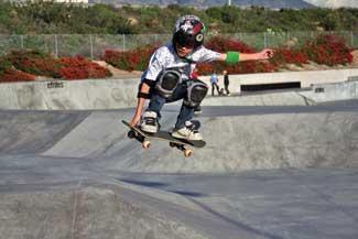
1 etnies Skatepark of Lake Forest Stephen Kelly, Editor Photo by Guy Nelson Lake Forest, Calif., pop. 78,000, packs 6,274 people per square mile into this most densely populated city in south Orange County. Incorporated in Dec. 1991, the city has expanded to encompass the communities of Foothill Ranch and Portola Hills. The Lake in the city name is really two artificial lakes around which are built custom homes and condos. The forest part is what is left over of 400 acres of eucalyptus trees planted in the 1900s by a landowner for a lumber operation. Historic photo Sat. Dec. 13, 2003, grand opening of the free public etnies Skatepark, Lake Forest, Calif., south Orange County. The city spearheaded the park. SITE Design Group of Solana Beach, Calif. designed the skate surfaces, California Skateparks of Ontario, Calif. constructed it and the Rabben/Herman Design Office of Newport

2 Beach provided the landscape architecture. The major financial sponsor of the skate park, etnies, manufactures skateboard shoes and clothing. Photo courtesy of Rabben/Herman Design Office The Birth of a Skate Park Based on citywide recreation surveys by Lake Forest, residents indicated a skate park was the top recreation priority. Just about everywhere you go in Southern California you ll see kids on skateboards, often on the sidewalks, or at office parks or just about any hard surface. These spaces often prohibit skateboarding, and so it s important they have a place to go, to practice their skills, have fun and just hang out. To design and construct the skate park, the city created a public-private partnership with etnies, a manufacturer of skateboard shoes and clothing that had recently relocated to Lake Forest. The city leadership and etnies saw the project as an ideal opportunity to fulfill this popular recreation need. A DG path runs from the boulevard through the buffer slope and climbs the hill past the amphitheater and to the skate park entry. Photo by Guy Nelson The Site The space, a remnant, is nestled between an elevated toll road, Serrano Creek and an equestrian/hiking trail. The site is also bordered by the busy thoroughfare of Lake Forest Boulevard.


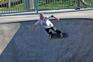
3 The skate park offers a large street area (stairs, ramps, flat bars, handrails, banks, ledges, rolls, flow bowls, T- bowl and peanut pool (shallower, less steep bowl). The majority of skateboarders ride the street stuff, which is a plus for those who ride the bowls. LASN watched an elder, perhaps early 40s, skating a bowl. It s fast, furious and physical and he soon came up the lip for a rest. Photo by Guy Nelson


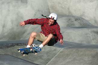
4 Aim For etnies the intent was a signature, quality skating surface that would also be a venue for national skating events the company would sponsor. The city of Lake Forest, of course, wanted this effort to reflect the pride it has in the community. The city was thrilled to bring this amenity to local residents and the broader Orange County community. The day LASN visited the park, we spoke with an elder skateboarder, perhaps 19 or 20, who was down from Los Angeles for the day with a few friends. That LA teens would make a two plus hour round-trip to etnies indicates the skate park is recognized as something special. Although the skate park is just off busy Lake Forest Boulevard, people cannot see the skaters from the street because of the site grading elevations. The roadside sloped planting buffer are bands of phormium ( Jack Spratt ), red fescue and some Manzanita shrubs. The existing eucalyptus street trees ( Red Iron Bark ) are continued at the

5 bottom of the slope. Photo by Guy Nelson The city was as concerned over the design of the surrounding landscape as they were of the concrete undulations. An added element in the mix was the city held an easement over a portion of the adjacent regional equestrian/hiking trail and maintenance access to Serrano Creek. From busy Lake Forest Blvd. the five 24-foot-tall light columns create an unmistakable identity for the skate park. The light columns, fabricated from 30-inch diameter perforated pipe, have interior illumination via two 400-watt uplights, projecting bright light sparkles. Edge-lit plastic caps the columns for a glowing effect. Pphoto courtesy of Rabben/Herman Design Office Role of the Landscape Architect The landscape architecture firm of Rabben/Herman Design Office of Newport Beach got the assignment as the lead consultant for the project, responsible for managing the team of architects, skate park designers and civil engineers. The landscape architects developed the master plan for the park and overall concept for integrating the skating surfaces and the exterior park into a unified design. The landscape architects also prepared the bidding documents for the site grading, hardscape, planting design, irrigation and signage. To assure a successful design and implementation, the landscape architects also led the public meetings and negotiations with Friends of the Serrano Creek, Orange County Harbor Beaches and Parks and the Orange County Drainage District.


6 Photo by Guy Nelson The landscape architecture design for the man-made park elements is inspired by the fluid back-and-forth motions of the experienced skate boarder on a flow course. The overlapping corrugated metal shade trellises and roof of the restroom/office building reflect this movement. The arc of the structures curves from right to left and then right again, terminating in the walls of the amphitheater. Photo courtesy of Rabben/Herman Design Office With etnies focused on the skate park elements, the SITE Design Group of Solana Beach, Calif. put its expertise to work to design the skate terrain and California Skateparks of Ontario, Calif. brought its experience to constructing the bowls and free-flow skating terrains. The challenges for the landscape architects was to integrate landscaping with hardscape elements, create an entry, fit in parking, design a drop off area, position seating areas for large skate board competition/events and make a landscape transition from the park proper to the trail area. The landscape architects had to build a focused identity for the park to reflect the enthusiasm and spirit of youthful athleticism in its materials and look.

7 Corrugated and galvanized metals, and Corten steel, were two of the primary materials. The Corten steel panels are punched and sandwiched with red acrylic plastic. The panels glow during sunsets and are backlit at night. The panels act as screen walls at the entrance to the restroom facility and in the perimeter fence surrounding the skate park. Photo by Guy Nelson Special Considerations The landscape architects find the overall design blurred the lines between the skating surface and the surrounding park. The skating surface features three distinct but integrated areas: the bowls, the flow course and the street course. The forms of the bowl course flow outward to the amphitheater while the geometry of the street course affects the walks, grading and overlooks adjacent to it. The design of the park incorporates traditional materials including corrugated metal pipe, Corten steel, red acrylic panels and metal mesh in unusual ways to create a unique look. A series of design decisions were introduced to discourage skaters from using areas other than the intended skating surfaces. The plaza hardscape is imprinted asphalt surfaces in a variety of patterns, including elevated, knobby circles and etched linings. This area is a 360 loop for parents to drop off skaters. A center section, which blocks vehicles with perimeter bollards, has pavers, slightly spaced. And wouldn t you know it, despite these rough, nonskate wheel-friendly plaza surfacings, when LASN was on site taking a closer look at the plaza hardscape, a skateboarder bumped over the pavers to talk with us.
8

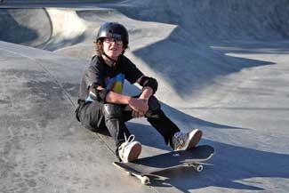
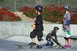
9 LASN dropped by etnies on a weekday afternoon just after school to catch the action. Pre-teens, teenagers and a few less spry skateboarders showed off for LASN photographer/graphic artist Guy Nelson. Photos by Guy Nelson The paths throughout the park are decomposed granite walkways, another inconvenient surface for skateboards. For the same reason the concrete seat walls are set in turf. It s not hard to visualize skateboarders grinding on the seat walls. Fortunately, there s plenty of grinding edges in the skate courses and bowls.


10 The close proximity of a regional equestrian/hiking trail gives those in the surrounding Lake Forest neighborhood pedestrian access to the skate park. The trail also affords maintenance access to the retention basin, relocated to the edge of the channel and separated from the skate park by a six-foot tall berm. Native oaks and sycamores are plentiful along the trail. Sage, octopus agave, island snapdragon, coyote bush, Calif. poppy, blue bedder and coffeeberry are just some of the shrubs. above, right: Equal emphasis was given to the landscape and amenities outside the skating area. Honey locust and Calif. sycamore trees, picnic tables, bike racks and benches form a little niche adjacent to the drop-off area. Photos courtesy of Rabben/Herman Design Office The equestrian/hiking trail was integrated into the design but visually separated from the more active recreational by a berm and native plantings. Grades alignments, widths and location of trees were coordinated with the drainage district to allow maintenance equipment access for the Serrano Creek channel. The design intent here was visually separating the trail from the more intensive uses of the skate park, but with a natural appearance, rather than an engineered one.


11 The plaza is a roundabout dropoff for parents, mostly in SUVs. The hardscape combines imprinted asphalt surfaces

12 in a variety of patterns, including elevated, knobby circles to mimic skate wheels, concrete and pavers. The knobs and etching are meant to discourage skateboard use. The day LASN was there, a skateboarder bumped over the central pavers to speak with us. The custom corrugated metal pipe columns with light bases are giant agave planters, perhaps inspired by Guilliver s voyage to Brobdingnag. Bollards protect the center area and also line the sidewalk. Photos by Guy Nelson You get a great view of the bowl areas from the amphitheater, whether sitting on the grass (Marathon Ile, a seed mix) or lounging on the seat walls. The bay laurels are in bloom on the hill. Skate park designer SITE Design Group, Solana Beach, Calif. Skate park builder California Skateparks, Ontario, Calif. Landscape Architecture Rabben/Herman Design Office, Newport Beach, Calif. Principals William Rabben, Daniel Herman, Tom Skinfill
PUBLIC REALM MASTER PLAN
 WESTSHORE BUSINESS DISTRICT PUBLIC REALM MASTER PLAN MASTER PLAN COMMITTEE MEETING MARCH 20, 2013 WESTSHORE BUSINESS DISTRCT PUBLIC REALM MASTER PLAN MACRO-SCALE CONCEPT: A PUBLIC REALM FRAMEWORK DEFINED
FOCUS AREA 1 - Alberta Avenue Pocket Park 3 (121 Ave and 92 St)
") FOCUS AREA 1 - Alberta Avenue Pocket Park 3 (121 Ave and 92 St) New benches Plant evergreen trees Widen existing sidewalk from 1.5m to 1.8m Marked crosswalk 1.8m wide sidewalk Add pedestrian oriented lights
FOCUS AREA 1 - Alberta Avenue Pocket Park 3 (121 Ave and 92 St) New benches Plant evergreen trees Widen existing sidewalk from 1.5m to 1.8m Marked crosswalk 1.8m wide sidewalk Add pedestrian oriented lights
Bicycle and Pedestrian Advisory Committee (BPAC) November 21, 2013
 November 21, 2013") Bicycle and Pedestrian Advisory Committee (BPAC) November 21, 2013 OVERALL LAND USE CONCEPT Overall Broadway Valdez District: 95.5 acres (35.1 acres right-of ways + 60.4 acres developable land) Plan Subareas:
Bicycle and Pedestrian Advisory Committee (BPAC) November 21, 2013 OVERALL LAND USE CONCEPT Overall Broadway Valdez District: 95.5 acres (35.1 acres right-of ways + 60.4 acres developable land) Plan Subareas:
Three Springs Design Guidelines Fencing and Wall Standards
 Three Springs Design Guidelines Fencing and Wall Standards Original Adopted: June 12, 2006 Minor Amendment: December 2012 Minor Amendment: March 23, 2017 TABLE OF CONTENTS: FENCING AND WALLS 1.0 INTRODUCTION
Streetscape: Core Shopping District
 Streetscape: Core Shopping District DRAFT DRAFT DRAFT May 00 Core Shopping District: Phase Blue Island s Core Shopping District is located along Western Avenue, between Grove and Union Streets. Streetscape
1.3 Pedestrian Environments
 SECTION 1: COMMERCIAL DEVELOPMENT 1.3 Pedestrian Environments Design Principle The quality of the pedestrian environment often defines the overall success of a commercial project. Attention to the development
Observations and Ideas: Toomer s Corner Streetscape Improvements
 Observations and Ideas: Toomer s Corner Streetscape Improvements AUBURN DOWNTOWN MASTER PLAN planning downtown s future August 26, 2013 Observations: Vertical Clutter at Corners 6 3 7 5 9 2 8 4 1 Excess
Guthriesville Village Manual of Written & Graphic Design Guidelines
 Exhibit B Revisions: May 23, June 21, July 20, September 20, & October 9, 2012 Updated: December 13, 2012; June 27, 2013; February 7, 2014 Outline of Contents: 1. Purpose and Applicability 2. Overall Form
Obey Creek PEDESTRIAN CIRCULATION EAST WEST PARTNERS PEDESTRIAN CIRCULATION CREEK SIDE LANE SLIP STREET SCOTT MURRAY MAIN STREETS EAST/WEST
 THE VILLAGE AT PEDESTRIAN CIRCULATION MAIN STREETS NORTH/SOUTH MAIN STREETS EAST/WEST SLIP STREET CREEK SIDE LANE PEDESTRIAN CIRCULATION DESCRIPTION: Circulation through the downtown of is organized by
MAG Town of Cave Creek Bike Study Task 6 Executive Summary and Regional Significance Report
 Page 1 MAG Town of Cave Creek Bike Study Task 6 Executive Summary and Regional Significance Report August 1, 2012 MAG Project #481 Page 2 Task 6 Executive Summary and Regional Significance Report Introduction
COPE PARK MASTER PLAN
 COPE PARK MASTER PLAN CBJ Parks & Recreation Department is in the process of creating a Master Plan for the Cope Park Area. New restrooms are designated to be constructed in the park in the next year.
Introduction Parks Open Space Standards Recreation & Open Space Land Use Design Principles
 Chapter Seven: Parks, Recreation, & Open Space Chapter Seven: Parks, Recreation, & Open Space Introduction Parks Open Space Standards Recreation & Open Space Land Use Design Principles September 2008 Page
Trail Feasibility. 1. Introduction FINAL. October What s inside?
 VOLUSIA COUNTY MPO CITY OF PORT ORANGE FINAL Trail Feasibility October 2006 What s inside? 1 Introduction 2 Project Purpose & Scope 3 Physical Inventory & Assessment of Right-of- Way 4 Trail Concept Plan
5 CIRCULATION AND STREET DESIGN
 5 CIRCULATION AND STREET DESIGN This chapter describes circulation and streetscape improvements proposed for the Northwest Chico Specific Plan Area. It includes detailed design specifications for existing
2009 NRPA Expo. 10 Things. All Successful Skateparks Have In Common
 2009 NRPA Expo 10 Things All Successful Skateparks Have In Common skateboardiasc.org skatepark.org tonyhawkfoundation.org Who We Are Volunteer Owned, Operated Sexy Executive Director Hundreds of Contributors
Non-required Fences Update
 Non-required Fences Update Quality of Life & Environment Committee January 11, 2016 Presented by the Department of Sustainable Development and Construction Purpose Follow up on the May 26, 2015, August
STREETSCAPE CONCEPTS
 STREETSCAPE S CARGO WAY CARGO WAY CYCLE TRACK Streetscape Concepts JENNINGS ST Illustrative Plan EVANS AVE PG&E BAY TRAIL HERON S HEAD PARK The recommended improvements build off the planned improvements
Emerson Circle Entrance
 Emerson Circle Entrance It is not clear that there is a park in this location without a sign. Access from Emerson Circle: The present sloped granite curb does not provide access immediately at the park
NW SKATEPARK OPEN HOUSE
 1 NW SKATE OPEN HOUSE WELCOME TO OPEN HOUSE #1 MERCER SKATE RELOCATION New Westminster Secondary School (NWSS) is being redeveloped and the existing Mercer Stadium skatepark needs to be relocated. As per
Blackfalds Downtown. Architectural Guidelines: Streetscape
 Blackfalds Downtown Architectural Guidelines: Streetscape Streetscape INTRODUCTION A variety of street furniture has been chosen for locations within the Town of Blackfalds Downtown and highway commercial
Clarkson Walkability Audit: Results and Recommendations Summary
 Clarkson Walkability Audit: Results and Recommendations Summary The following document was prepared by the Region of Peel and includes a summary of comments made by participants during our breakout discussion
Figure 4-10: Pedestrian Improvements Types of Potential Station Area Improvements - Place-Making Improvements
 INCORPORATE FEATURE PAVIN IN CROSSWALK AND INTERSECTION FIELDS Identifies high-priority pedestrian areas and create a station identity through colorful and interesting patterns ADD CURB EXTENSIONS Extending
DRAFT. Malibu Bluffs Park Skate Park Facility Site Assessment. Prepared For: The City of Malibu Parks and Recreation Department
 Malibu Bluffs Park Skate Park Facility Site Assessment Prepared For: The City of Malibu Parks and Recreation Department Prepared on February 28, 2013 By: 1 INTRODUCTION AND PROJECT BACKGROUND For more
6925 & 6965 LUSK BOULEVARD CLASS A LAB AND OFFICE SPACE
 6925 & 6965 LUSK BOULEVARD CLASS A LAB AND OFFICE SPACE UTC TORREY PINES 5 ACCESS TO MOUNTAIN AND ROAD BIKING TRAILS 805 WATERIDGE CIRCLE LUSK BOULEVARD 6965 6925 COME ON IN CAFE TELESIS COURT WATERIDGE
TRANSPORTATION STANDARDS
 INTRODUCTION LOCAL STREETS ON-STREET PARKING SIDEWALKS STREET LIGHTING STREET FURNISHINGS TRAFFIC CALMING STREET TREES MEDIAN PLANTING BOULEVARD LOCATIONS VILLAGE CENTER STREET LOCATIONS RESIDENTIAL STREET
Complete Streets. Designing Streets for Everyone. Sarnia
 Complete Streets Designing Streets for Everyone Sarnia Complete Streets ~ Sarnia ~ 2018 Introduction Our City is made up of a network of streets that we use to go for a walk, cycle to work, drive to the
Ocean Park Boulevard Green Street Project Alternatives & Trade Offs
 Planning Commission March 4, 2009 Ocean Park Boulevard Green Street Project Alternatives & Trade Offs Purpose of Tonight s Meeting Review concept plans and options Provide input on alternatives and trade-offs
MEDIAN DESIGN example median A
 MEDIAN DESIGN example median A MLK Blvd Design Workshop #3 September 21, 2010 Participants voted on each idea, gave comments about specific ideas or general comments about all ideas. Comments and suggestions
10A. DATE: October 5, Pedestrian and Bicycle Advisory Committee. Kevin Colin, Deputy Planning Manager Curt Bates, City Engineer
 10A DATE: October 5, 2016 TO: PREPARED BY: SUBJECT: Pedestrian and Bicycle Advisory Committee Kevin Colin, Deputy Planning Manager Curt Bates, City Engineer Discussion and Provide Comments, Associated
Incentive Zoning. Zoning Ordinance Advisory Committee June 21, Pam Thompson, Senior Planner, Sustainable Development and Construction
 Incentive Zoning Zoning Ordinance Advisory Committee June 21, 2018 Pam Thompson, Senior Planner, Sustainable Development and Construction Presentation Overview Stakeholder questions Updated charts Design
Appendix B - Street Sections
 Appendix B - Street Sections 6TH STREET CORRIDOR PLAN STREET SECTIONS The street sections in Appendix B include recommended improvements to streets for North Glenwood. They include existing conditions
Design of Stanley Park S-Curve
 ADMINISTRATIVE REPORT Date: May 4, 2001 TO: FROM: Author/Local: F. Klotzbach/7118 RTS NO. 01644 CC File No. Standing Committee on Transportation and Traffic General Manager of Engineering Services, in
ROUTE 81 CORRIDOR STUDY DESIGN CONCEPTS
 RT 81 Corridor Study CLINTON ROUTE 81 CORRIDOR STUDY DESIGN CONCEPTS View north on High Street, with potential improvements to the streetscape Draft Recommendations November 8 th, 2018 TOWN OF CLINTON
Chapter 4 TOOLBOX AND SAMPLE BIKE BOULEVARD LAYOUT
 Chapter 4 TOOLBOX AND SAMPLE BIKE BOULEVARD LAYOUT OVERVIEW This chapter describes a cohesive set of strategies to create a bicycle boulevard, namely to make streets safer and more efficient for bicycle
RENOVATION MASTER PLAN
 RENOVATION MASTER PLAN For: Field Club of Omaha Omaha, Nebraska DATE: JUNE 20,, 2018 P r e p a r e d b y : 3250 BRINKERHOFF ROAD KANSAS CITY, KANSAS 66115 PHONE: 913.621.5214 FAX: 913.621.0760 EXECUTIVE
WHAT IS YOUR MAIN CONNECTION TO THE SKATE PARK ACTIVITY PLAN?
 WHAT IS YOUR MAIN CONNECTION TO THE? Place one of your dots in a circle below I m a skater I m a parent I m a neighbor of a skatepark I own a skate-related business I m a BMX rider I m a scooter or in-line
4.0 STREETSCAPE ELEMENTS
 .0 Table 3 lists streetscape elements and their maintenance requirements. The figures that follow the table illustrate the streetscape elements. With respect to maintenance, if an element is required as
Chapter 3 DESIGN SPECIFICATIONS
 Brampton PathWays Planning and Design Guidelines 27 Chapter 3 DESIGN SPECIFICATIONS 3.1 CLASS 1 MULTI-USE PATH Off-road multi-use trails are the backbone of the Brampton PathWays Network. They are typically
14 TH STREET TRANSPORTATION & STREETSCAPE DESIGN STUDY PLAN B PLAN B TRANSPORTATION & STREETSCAPE RECOMMENDATIONS
 14 TH STREET TRANSPORTATION & STREETSCAPE DESIGN STUDY PLAN B PLAN B TRANSPORTATION & STREETSCAPE RECOMMENDATIONS 141 Symbols Recommendations - Southern End of 14th Street Study Area Streetscape Each icon
McLaren Park. Disc Golf Meeting. April 20, 2010
 McLaren Park Disc Golf Meeting April 20, 2010 Welcome! Introductions Ground Rules Review Questions and Topics to Cover Background Presentation by the San Francisco Disc Golf Club Questions and Answers
UPDATE ARLINGTON COUNTY. Bicycle Parking Standards
 2018 UPDATE ARLINGTON COUNTY Bicycle Parking Standards INTRODUCTION This guide is designed to give developers, architects, property managers, construction professionals, and County staff, the knowledge
Village of Cuba St. Francis of Assisi Park Improvement Plan Community Input Report
 Village of Cuba St. Francis of Assisi Park Improvement Plan Community Input Report Presented to the Village of Cuba November 28, 2012 by Healthy Kids, Healthy Cuba and Step into Cuba At the request of
KEARNY MESA COMMUNITY PLAN UPDATE
 KEARNY MESA COMMUNITY PLAN UPDATE January 18, 2018 SUBCOMMITTEE MEETING Mobility Concepts and Urban Design Presentation Outline Mobility Concepts: Multimodal Planning Toolbox Presentation and Activities
Community Meeting February 27, 2007 Dorchester Avenue Transportation & Streetscape Improvements Action Plan February 27, 2007
 Community Meeting Tonight s Agenda 6:00 Introductions South Boston/Dot Ave Improvement Study Background 6:15 Consultant Introductions Review of Scope and Schedule Review of Proposed Corridor Wide Guidelines
Support Infrastructure
 GUIDANCE NOTE 06 Support Infrastructure 96 COMMUNITY CRICKET FACILITY GUIDELINES VERSION SEPTEMBER 2015 SECTION 2 Guidance Note 06 Support Infrastructure INTRODUCTION Outside of the main playing, training
City of Margate, Florida. Neighborhood Traffic Management Manual
 City of Margate, Florida Neighborhood Traffic Management Manual Table of Contents Page No. I. INTRODUCTION... 1 II. TRAFFIC CALMING REQUEST AND PROCESSING PROCEDURES... 2 1. COMPLETE AND SUBMIT PROJECT
4.7 Landscape Provisions.
 4.7. A. Intent. Landscaping of required Yards and required Bufferyards is an essential element of the design of a site with respect to promoting the public health, safety, comfort, convenience and general
Baseball and Books. Master of Architecture. Jacob Tuzzo
 Baseball and Books Jacob Tuzzo Thesis submitted to the faculty of Virginia Polytechnic Institute and State University in partial fulfillment of the requirements of the degree of Master of Architecture
Table #6 VISION CHARACTERISTICS
 Table #6 VISION White Flint is a place to live, work, play, shop, and walk with sufficient density to encourage quality redevelopment. Vibrant streets and consistent streetscapes are important. CHARACTERISTICS
Chapter 11. Culverts and Bridges Design Checklist for Culvert Design
 Yes No N/A Design Requirements I. GENERAL DESIGN GUIDELINES Chapter 11. Culverts and Bridges A. Culvert design is in accordance with the Culverts chapter of Volume 2 of the UDFCD Manual for additional
Main Building and raft building viewed from the south side of the Oklahoma River. The white water Main Building anchors the development.
 Client: OKCMAPS Office Completion: April 2016 Scope: Main Building: 16,326 SF Raft Storage Building: 2,041 SF Kayak Storage Building: 1,348 SF Rotary Point Pavilion: 1,387 SF Cost: $45.2 M Awards: RIVERSPORT
RIVERSIDE SKATE PARK Located at 109th Street in Riverside Park Borough of Manhattan
 RIVERSIDE SKATE PARK Located at 109th Street in Riverside Park Borough of Manhattan Community Board 7 July 5, 2016 Parks Capital Design W Architecture & Landscape Architecture California Skateparks HERY
Montgomery County Life Sciences Center Loop Trail
 Montgomery County Life Sciences Center Loop Trail Advisory Committee Meeting #1 February 10, 2015 Agenda 1. Project Background 2. Existing Conditions Analysis 3. Examples from Elsewhere 4. Discussion Project
San Bernardino County Non-Motorized Transportation Plan - Chapter 5
 City of Upland Population 76,106 City Overview The City of Upland was incorporated on May 15, 1906, after previously being named North Ontario. The City was originally established as an irrigation colony
PROJECT KEY TYPICAL SECTION 1 =60
 6 WASHINGTON BLVD - BETWEEN NE 1ST ST AND NE 3RD ST Washington Boulevard is a low volume, low speed one-way road, signed for no street between NE 1st Street and NE 2nd Street, and closed to traffic between
SERVICE AREA DATA THEMES
 SERVICE AREA DATA THEMES SUMMARY: The CAC was randomly broken up into 6 working groups. Each group reviewed the service area data packet and identified key themes that should be addressed in the upcoming
Review of Guidelines for Cycleway Safety Fencing
 Review of Guidelines for Cycleway 1.0 PURPOSE 1.1 This document is meant to provide a review of available reference documents for determining appropriate fencing requirements for cycleway paths and shared
To: Planning Commission Date: September 19, 2012 From: By: Subject:
 To: Planning Commission Date: September 19, 2012 From: By: Subject: City of Woodinville, WA Report to the planning commission 17301 133 rd Avenue NE, Woodinville, WA 98072 www.ci.woodinville.wa.us Richard
A. Arlington County Master Transportation Plan Pedestrian Element B. Arlington County Horizontal Standards H-3.1 Driveway Entrances
 GENERAL 1. Description This standard identifies minimum requirements that shall be met for all accessible ramps in the design and construction of elements for Arlington County Horizontal Design Standards.
Section 5: Bike and Pedestrian
 Section 5: Bike and Pedestrian Existing Conditions: One defining feature of Glynn County appreciated by both residents and visitors is the extensive sidewalk and bike path system. The City of Brunswick,
City of Roseville Section 13 Design Standards. _Bikeways January 2016 SECTION 13 BIKEWAYS
 SECTION 13 BIKEWAYS 13-1 GENERAL The City of Roseville bikeway standards are designed to insure that transportation and recreational bikeways are constructed in a manner that would provide a safe and comfortable
Georgetown Skate Park & Action Sports Needs Assessment Project Background
 Project Background Purpose of Study: The purpose of this study is to confirm needs for new action sports opportunities in Georgetown, and develop prioritized implementation strategy. A focus of this project
Arts Center Rail Station Accessibility Assessment
 Arts Center Rail Station Accessibility Assessment Joel Anders, Arnaud Huguet, and Alex Poznanski 25 July 2012 Table of Contents EXECUTIVE SUMMARY... 1 MISSION STATEMENT... 2 OVERVIEW... 2 CROSSWALKS AND
4. Action Plan & Projects
 4. Action Plan & Projects 45 46 ACTION PLAN AND PROJECTS The Action Plan organizes the list of transportation projects described in the Mobility Framework Plan section into short-term (0-5 years) and long-term
Healthy Built Environments Cowlitz-Wahkiakum County, Washington
 Healthy Built Environments Cowlitz-Wahkiakum County, Washington Bringing Back Active Transportation and Health Presented By Dan Burden, Blue Zones, LLC Livability/Health and the role of Place, Walkability
7/23/2017 VIA . Michael Hanebutt City of Sacramento Community Development Department 300 Richards Boulevard, 3 rd Floor Sacramento, CA 95811
 7/23/2017 VIA EMAIL Michael Hanebutt City of Sacramento Community Development Department 300 Richards Boulevard, 3 rd Floor Sacramento, CA 95811 RE: 65 th Street Apartments (DR17-220) Dear Mr. Hanebutt:
DRAFT. System Components. Greenway Trails. Introduction. Trail Types. Zebulon Greenway Master Plan
 5 System Components Wakefield Street Photo Simulation showing Sharrows Introduction The Master Plan identifies various system components that, together, create a comprehensive greenway system. These components
*A Certificate of Survey for the property may be on file at City Hall if the house was built after 1984.
 Swimming Pools ** Permits are required for pools having a water surface area exceeding 100 square feet ** Permits are required for pools having a water surface area exceeding 100 square feet (11-3-3/8
1. In Reach 3, Perry, Knox, Lowell, and Hooker have crossings identified. What are these?
 Round 3 Integration Plan Integration Plan Public Meeting Denver Urban Waterways Study Meeting Date: Location: Hosted by: Attendees: August 30 2016, 5:30-7:30pm Barnum Recreation Center City and County
David Hung, Associate Planner City of Sacramento Community Development Department 300 Richards Boulevard, 3 rd Floor Sacramento, CA
 June 13, 2016 VIA EMAIL David Hung, Associate Planner City of Sacramento Community Development Department 300 Richards Boulevard, 3 rd Floor Sacramento, CA 959811 RE: Fire Station 14 (DR16-128) Dear Mr.
5. Automobile Circulation, Wayfinding and Signage
 5. Automobile Circulation, Wayfinding and Signage Policy: The City Center should have a balanced, safe, and interconnected circulation system that provides expanded travel opportunities for transit, pedestrian,
S T A T I O N A R E A P L A N
 The Circulation and Access Plan describes vehicle, pedestrian, and transit improvements recommended within the Concept Plan. In order to create and sustain a vibrant business district that provides pedestrian-friendly
Vision: Traditional hamlet with an attractive business/pedestrian friendly main street connected to adjacent walkable neighborhoods
 N D. Focus Area II Vision: Traditional hamlet with an attractive business/pedestrian friendly main street connected to adjacent walkable neighborhoods Transit Road Focus Area II is located in the Hamlet
Schutte Park Master Plan February 14, 2017
 Schutte Park Master Plan February 14, 2017 Overview The Schutte Park Master Plan is a product of the City of Dover Recreation Needs Assessment. This primary planning document for all of the city parks
Chapter 3.9 Timbercrest Elementary School. Volusia County MPO. November 2008
 Chapter 3.9 Timbercrest Elementary School Deltona, FL Volusia County MPO November 2008 Volusia County MPO School Bicycle and Pedestrian Review Study, Phase 3B School Summary Timbercrest Elementary School
Tonight is for you. Learn everything you can. Share all your ideas.
 Strathcona Neighbourhood Renewal Draft Concept Design Tonight is for you. Learn everything you can. Share all your ideas. What is Neighbourhood Renewal? Creating a design with you for your neighbourhood.
WHITE STREET/ ENGLISH PLAZA STREETSCAPE IMPROVEMENT PROJECT
 WHITE STREET/ ENGLISH PLAZA STREETSCAPE IMPROVEMENT PROJECT 1 Project Goals 1 Improved Safety: Lighting, Multi-Modal Circulation, Emergency Access, Tripping Hazards; Stormwater 4 Environmental Performance:
Section 7 Complete Green Street Guidelines DRAFT
 Section 7 Complete Green Street Guidelines DRAFT 1 Section: 7.0 COMPLETE GREEN STREET GUIDELINES These guidelines serve as options to mitigate the environmental impact of a project as well as guide the
10/30/2012 VIA
 10/30/2012 VIA EMAIL David Hung, Associate Planner Community Development Department, Current Planning Division City of Sacramento 300 Richards Blvd., 3 rd Floor Sacramento, CA 95811 RE: The Cannery On-Site
RLRC COMMUNITIES EAST GRAND FORKS AREA CHARACTER THE RED LAKE RIVER & THE RED RIVER OF THE NORTH CONFLUENCE EAGLE POINT BOAT LAUNCH DESIGN
 AREA CHARACTER THE RED LAKE RIVER & THE RED RIVER OF THE NORTH CONFLUENCE EAGLE POINT BOAT LAUNCH DESIGN DESIGN DETAILS 135 AREA CHARACTER East Grand Forks a city of 7,501 people is located across the
CHAPTER 6 Focus Areas Circle of Palms Passage Plaza Improvements
 1 before 1 after: Downtown Elements bring human scale, comfort, and a social character to the Plaza. CHAPTER 6 Focus Areas Circle of Palms Passage Plaza Improvements 179 1 Focus Area: Paseo de San Antonio
This chapter describes the proposed circulation system and transportation alternatives associated with
 5.0 Circulation 5.1 OVERVIEW This chapter describes the proposed circulation system and transportation alternatives associated with West Landing, and summarize the information contained in the Existing
PEDESTRIAN CIRCULATION & STREETSCAPE DESIGN
 CHAPTER 4 Chapter 4 Pedestrian Circulation & Trails PEDESTRIAN CIRCULATION & STREETSCAPE DESIGN In recent years, the City has constructed new sidewalks and enhanced existing ones in the downtown with brick
BOLAND DRIVE PATH PROJECT. Martin Le Jack Reilly Paul Rodriguez Allison Rotella Maria Wilson
 BOLAND DRIVE PATH PROJECT Martin Le Jack Reilly Paul Rodriguez Allison Rotella Maria Wilson INTRODUCTION TO PROJECT The purpose: to construct a multi-purpose path, which will connect two existing bike
Microscale Audit of Pedestrian Streetscapes (MAPS), Mini Version
, Mini Version") Microscale Audit of Pedestrian Streetscapes (MAPS), Mini Version Training Manual & Picture Guide Developed by: Carrie Geremia Kelli Cain Revised February 11, 2014 Tool and protocol developed by: James
Microscale Audit of Pedestrian Streetscapes (MAPS), Mini Version Training Manual & Picture Guide Developed by: Carrie Geremia Kelli Cain Revised February 11, 2014 Tool and protocol developed by: James
Active Transportation Rail to River Corridor. Community Meeting - Segment A
 Active Transportation Rail to River Corridor Community Meeting - Segment A June 29, 2017 Tonight s Agenda > Open House (30 min) > Welcome / Project Overview > Presentation of 30% Design Refinements > Next
TRANSPORTATION ALTERNATIVES PROGRAM: SELECTED PROJECTS AND FUNDING ALLOCATIONS
 ITEM #9: TRANSPORTATION ALTERNATIVES PROGRAM: SELECTED PROJECTS AND FUNDING ALLOCATIONS The Transportation Alternatives Program (TAP) created by MAP-21 requires that 50% of the program funds received by
Portage Bay Park Design Commission Review 4: 90% Design Development January 5, 2017
 to be updated to reflect base bid condition Portage Bay Park Design Commission Review 4: 90% Design Development January 5, 2017 Previous Site Plan POTENTIAL PARK CONNECTION & MID-BLOCK CROSSING BOAT STREET
MARTIN LUTHER KING JR. WAY
 OCTOBER 2011 40 Vision and Goals The Martin Luther King, Jr. Way Illustrative Master Plan that follows has been developed through a process of community involvement. It expresses a long term vision for
PROCEDURE FOR ACCOMMODATING PEDESTRIANS IN WORK ZONES FOR CONSTRUCTION AND MAINTENANCE
 PROCEDURE FOR ACCOMMODATING PEDESTRIANS IN WORK ZONES FOR CONSTRUCTION AND MAINTENANCE A.1 STANDARD Measures shall be taken to accommodate pedestrian traffic through and/or around Work Zones for Construction
Right-of-Way Standards
 City of Ketchum P.O. Box 2315 480 East Ave. N. Ketchum, ID 83340 Right-of-Way Standards Effective July 2015 Introduction A public right-of-way is defined as improved or unimproved public property dedicated
The University of Alabama Pedestrian System Plan
 The University of Alabama Pedestrian System Plan 1 Introduction The University of Alabama Campus Master Plan was developed with a comprehensive open space, accessibility, and circulation system in mind,
INTEGRATED ACCESSIBILITY STANDARDS REGULATION. Training Module for the Design of Public Spaces Standard
 INTEGRATED ACCESSIBILITY STANDARDS REGULATION Training Module for the Design of Public Spaces Standard DISCLAIMER This training resource provides an overview of Part IV.1 of the Integrated Accessibility
Mayor s Bicycle Advisory Council. Wednesday, December 13 th, 2017
 Mayor s Bicycle Advisory Council Wednesday, December 13 th, 2017 Bicyclist Fatalities, Year to Date (January 1 November 30, 2017) - MBAC Briefing Bicyclist Fatality Statistics Year to date total, 2017
Right-of-Way Standards
 City of Ketchum P.O. Box 2315 480 East Ave. N. Ketchum, ID 83340 Right-of-Way Standards Effective July 2015 Introduction A public right-of-way is defined as improved or unimproved public property dedicated
Street Paving and Sidewalk Policy
 City Commission Policy 600 Street Paving and Sidewalk Policy DEPARTMENT: Public Works DATE ADOPTED: June 7, 1995 DATE OF LAST REVISION: December 10, 2014 Policy No. 600.01 AUTHORITY: PASS City of Tallahassee-Leon
C A M P U S W I D E G U I D E L I N E S S T R E E T F U R N I T U R E
 C A M P U S W I D E G U I D E L I N E S Benches Light Fixtures Manufacturer: Model: Finish/Color: Special Features: White Oak Bench Local Craftsperson: Kirkpatrick Woodworks Jim Kirkpatrick 3315-C Highway
01. VICINITY OF GREENBRAE POC: EXISTING CONDITIONS
 01. VICINITY OF GREENBRAE POC: EXISTING CONDITIONS Existing Bus Stop Existing US101 On-ramp Existing POC Old Redwood Highway Rich Street City ROW Environmental Study Limit Industrial Way NO DESIGNATED
Option W: N. Washington Street Project
 Option W: N. Washington Street Project Location: one block of North Washington Street, between West Broad Street and Park Avenue Description: upgrades to existing lighting new brick sidewalk to replace
TO: FROM: SUBJECT: RECOMMENDATION REPORT SUMMARY BOARD AUTHORITY
 February 8, 2018 TO: Park Board Chair and Commissioners FROM: General Manager Vancouver Board of Parks and Recreation SUBJECT: Douglas Park Playground Replacement - Construction Contract RECOMMENDATION