Time Series Analysis of Cedar Bayou
|
|
|
- Vivien Joseph
- 5 years ago
- Views:
Transcription

1 Time Series Analysis of Cedar Bayou Mukesh Subedee James Gibeaut, Diana Del Angel Coastal & Marine Geospa<al Lab Harte Research Ins<tute for Gulf of Mexico Studies John C. Stennis Space Center, MS NGI Student Summit August 1 st, 2013
2 Mukesh Subedee 2 nd year Masters Student, GIS for Development and Environment (GISDE), Clark University MS Computer Science, University of Nebraska- Lincoln Research Interest: GIS and spa<al analysis Remote Sensing Web mapping

3 Dr. James Gibeaut Endowed Chair for Geospa<al Sciences, Harte Research Ins<tute for Gulf of Mexico Studies (HRI), Texas A&M University- Corpus Chris< Director, Coastal & Marine Geospa<al Lab, HRI Associate Professor of Geology, Texas A&M University- Corpus Chris< Exper<se: Coastal Morphodynamics GIS Modeling Effects of Sea level Rise

4 Project Overview Cedar Bayou a natural unstable pass that connects the Gulf of Mexico and Mesquite Bay Passage for migratory organisms Connec<on to Vinson Slough Back- island is rela<vely stable but beach zone is remarkably changed Status: open and closed regularly
5 Research Objec<ve Coast and Harbor Engineering (2005) approach: Dredge a straight Cedar Bayou connec<on to the Gulf, connec<on to Vinson Slough, and reconstruc<on of the submerged ebb shoal with dredged material Will Cedar Bayou stay open? Based on morphologic responses of the pass to past processes What happened in the past? Data Used: Aerial Imagery ( ) River discharge data ( ) Tropical Storm and Hurricane data ( ) Tide data ( ) Wave Hindcast data ( ) LiDAR and Historical Shoreline ( )

6 Tide and Wave Energy Morphology is constantly modified with the complex temporal and spa<al interac<ons of waves, <des, and longshore currents Tide dominated system Wave dominated system


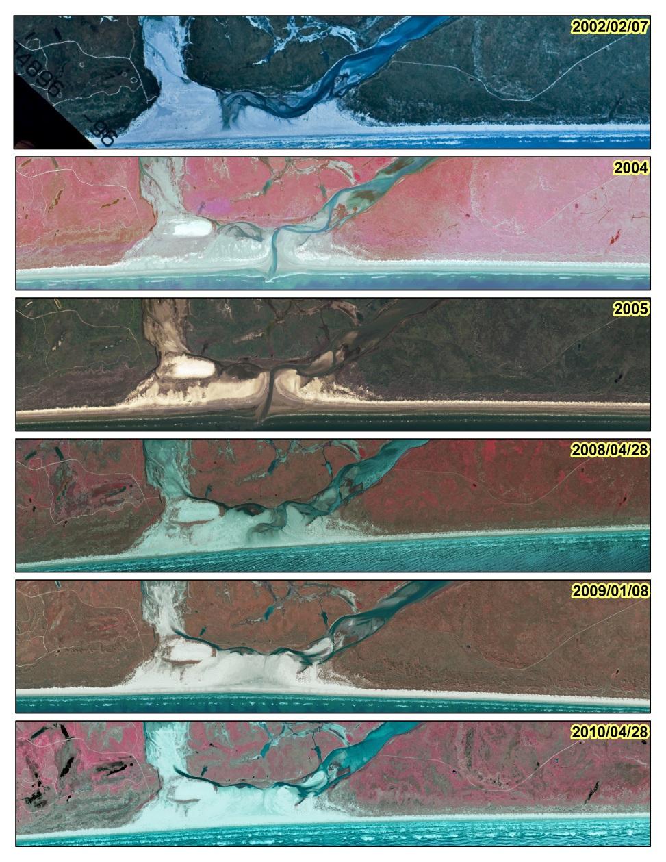
7 Aerial Imagery
8 Throat Width Calcula<on Date Throat Width (meter) Observa=on Significant connec<on between CB and VS, single channel to the Gulf 4/22/ Separate channels from both CB and VS; CB and VS connected 9/1/ Channel move westward with CB and VS merged as a single channel to the Gulf 2/1/ Small channel between CB and VS, channel has further shijed towards VS 11/11/1979 CLOSED Closed by sand berm to prevent pollu<on from Ixtoc I oil spill (June 1979) 2/12/ No more sand berm, very small opening to the Gulf; small connec<on between CB and VS 11/5/ CB and VS s<ll connected but even smaller channel from VS than 1981, the island on the mouth of VS has increased and the pass has moved slightly westward than /6/ Increasing seashore mouth width, slightly wider channel to the Gulf than /6/ Dredged in June 1988 that shijed the pass toward CB and completely closed along VS, very small connec<on between CB and VS 12/10/ Throat width reduces even more with barely connec<on between CB and VS 3/18/ Almost no connec<on between CB and VS 2/7/2002 CLOSED Closed, although 300,000 cu yards dredged in 1995 and hurricane in Narrow channel and low water level, hurricane Claudeke in 2003 could have opened the channel Could be the result of hurricane Emily in 2005 as it looks like high <de event 4/28/2008 CLOSED Drainage channel can be seen 1/8/2009 CLOSED No channel at all 4/28/2010 CLOSED No channel

9 Tropical Storm and Hurricane Wide open to marginally open 1979 Marginally opened Closed Dredged
10 50000 Surface Water Discharge Mission River Daily Discharge Present (H 3 /s) Discharge /01/38 12/02/39 11/01/41 10/02/43 09/01/45 08/02/47 07/02/49 06/02/51 05/02/53 04/02/55 03/02/57 01/31/59 12/31/60 12/01/62 10/31/64 10/01/66 08/31/68 08/01/70 07/01/72 06/01/74 05/01/76 04/01/78 03/01/80 01/30/82 12/31/83 11/30/85 10/31/87 09/30/89 08/31/91 07/31/93 07/01/95 05/31/97 05/01/99 03/31/01 03/01/03 01/29/05 12/30/06 11/29/08 10/30/10 09/29/ Copano Creek Daily Discharge 1970 Present (H 3 /s) Discharge /24/69 3/8/71 7/20/72 12/2/73 4/16/75 8/28/76 1/10/78 5/25/79 10/6/80 2/18/82 7/3/83 11/14/84 3/29/86 8/11/87 12/23/88 5/7/90 9/19/91 1/31/93 6/15/94 10/28/95 3/11/97 7/24/98 12/6/99 4/19/01 9/1/02 1/14/04 5/28/05 10/10/06 2/22/08 7/6/09 11/18/10 4/1/12 8/14/13

11 Tide Effect Hourly observed water level: Maximum: m Minimum: m Datum: MSL
 are likely to pass through the inlets but the shorter- period varia<ons are significantly Range of <de varies over")

12 Tide Effect Gulf of Mexico seafront <de is described by hr semidiurnal and hr diurnal <de, and 13.6 day fortnightly cycle and semi- annual mode of <de. The slower, longer- period varia<ons (fortnightly and semi- annual <des) are likely to pass through the inlets but the shorter- period varia<ons are significantly Range of <de varies over filtered a out. period of 2 weeks Cyclic smoothed annual varia<on, exhibit 2 maxima (Fall & Spring) and 2 minima (Winter & Summer) When range is maximal: hr periodicity When range is minimal: hr periodicity The <de in the Gulf loses most of its energy as it passes through the inlets. S<lling well effect: inlet acts as a small port that connects a large oscilla<ng chamber of water to smaller chamber in co- oscilla<on.


13 Wave Hindcast Average wave height: : m : m No significant difference in wave height over <me
14 Shoreline Change Shoreline Change between 1860 and 2012 Shoreline Movement (m) 120 Landward Movement 0 Cedar Bayou Channel Seaward Movement
15 Conclusion For Cedar Bayou to remain open: Need of sufficient channel flow to remove sediments deposited in the channel by longshore drij From our observa<ons, The s<lling well effect reduces <dal energy when passing through the channel The fresh water discharge into the bay is not able to maintain the opening The occurrence of large hurricanes and dredging ac<vi<es have historically played a major role in the opening/closing of Cedar Bayou However, varia<ons in non- storm <de and wave energy are not strongly related to the opening/closing of Cedar Bayou
16 Conclusion Concerns regarding the project plan: Vinson Slough is only dredged to connect Cedar Bayou channel which would only connect Aransas Bay during high <de The claim that the ebb delta was present cannot be verified Need of jeqes and con<nuous maintenance dredging Environmental impacts
17 Use of Metadata It helps to find data, and also helps to answer many ques<ons about the dataset. Created metadata in progress NCDDC MERMAid: Slow, slow, slow!!
18 Skills Learned and Challenges Skills Learned Data acquisi<on LiDAR data usage on Shoreline Extrac<on Challenges Lack of Metadata Overwhelming amount of data Terrestrial laser scanning Real Time Kinema<c (RTK) data collec<on


19 Looking Back: Value of the An excep<onal opportunity Understanding barrier Island forma<on to other process informa<on Field observa<ons and data collec<on methods Diverse research group Internship
20 References Ward, George H. "Processes and trends of circula<on within the Corpus Chris< Bay na<onal estuary program study area." (1997). Ward, George H. "A <me line of Cedar Bayou." (2010). Shepsis, Vladimir, and Joshua Carter. "Cedar Bayou Inlet dynamics and engineering." Proc. Coastal Sediments 07 (2007). Wilkinson, Bruce H. "Matagorda Island, Texas: the evolu<on of a Gulf Coast barrier complex." Geological Society of America Bulle<n 86, no. 7 (1975): MORTON, ROBERTA, CG GROAT, and ACTING DIRECTOR. "Shoreline Changes on Matagorda Peninsula (Brown Cedar Cut To Pass Cavallo) An Analysis of Historical Changes of the Texas Gulf Shoreline." (1976). White, William, Calnan, Thomas, Tremblay, Thomas, Waldinger, and Rachel "Status and trends of estuarine marshes on barrier islands of the Central and Upper Texas Gulf Coast." 14 th Biennial Coastal Zone Conference (2005). Bermudez, Hugo E., Shepsis, Vladimir, and Carter, Josh. Restora<on of Cedar Bayou and Vinson Slough Phase 1. Coast & Harbor Engineering (2005).
,")

21 Acknowledgements Dr. James Gibeaut, Mentor, Coastal & Marine Geospa<al Lab (CMGL), HRI Diana Del Angel, Costal Geoscien<st, CMGL JoAnn Moody, Internship Coordinator, NOAA- NGI Diversity Internship NOAA- NGI Diversity Internship Program CMGL Crew
22 Thank You!
Reading Material. Inshore oceanography, Anikouchine and Sternberg The World Ocean, Prentice-Hall
 Reading Material Inshore oceanography, Anikouchine and Sternberg The World Ocean, Prentice-Hall BEACH PROCESSES AND COASTAL ENVIRONMENTS COASTAL FEATURES Cross section Map view Terminology for Coastal
Shorelines Earth - Chapter 20 Stan Hatfield Southwestern Illinois College
 Shorelines Earth - Chapter 20 Stan Hatfield Southwestern Illinois College The Shoreline A Dynamic Interface The shoreline is a dynamic interface (common boundary) among air, land, and the ocean. The shoreline
Figure 1. Schematic illustration of the major environments on Mustang Island.
 STOP #1: PACKERY CHANNEL BEACH TO BAY We will start this field guide near the north jetty of Packery Channel and hike across the island to Corpus Christi Bay (fig. 1). The island emerges from the Gulf
Evaluation of Placement Alternatives for Matagorda Ship Channel Bottleneck Removal
 Evaluation of Placement Alternatives for Matagorda Ship Channel Bottleneck Removal James Rosati III Ashley E. Frey CPT Grays Harbor, WA Wood Wood chips Flour Other CMS Shark River Inlet, NJ US Army Corps
Assateague Island National Seashore North End Restoration Project Timeline
 Assateague Island National Seashore North End Restoration Project Timeline Date Event Some information provided in the Project Introduction document. Detailed events are available in a timeline compiled
Texas passes, longshore transport, hurricanes, beach erosion and sea level
 Texas passes, longshore transport, hurricanes, beach erosion and sea level Richard L. Watson, Ph.D. (361) 749-4152 Field work can be strange! 120,000 years of sea level Years each zone exposed above S/L
Oceans and Coasts. Chapter 18
 Oceans and Coasts Chapter 18 Exploring the oceans The ocean floor Sediments thicken and the age of the seafloor increases from ridge to shore The continental shelf off the northeast United States Constituent
Volume and Shoreline Changes along Pinellas County Beaches during Tropical Storm Debby
 Volume and Shoreline Changes along Pinellas County Beaches during Tropical Storm Debby Ping Wang and Tiffany M. Roberts Coastal Research Laboratory University of South Florida July 24, 2012 Introduction
Inlet Management Study for Pass-A-Grille and Bunces Pass, Pinellas County, Florida
 Inlet Management Study for Pass-A-Grille and Bunces Pass, Pinellas County, Florida Final Report Submitted By Ping Wang, Ph.D., Jun Cheng Ph.D., Zachary Westfall, and Mathieu Vallee Coastal Research Laboratory
EVALUATION OF BEACH EROSION UP-DRIFT OF TIDAL INLETS IN SOUTHWEST AND CENTRAL FLORIDA, USA. Mohamed A. Dabees 1 and Brett D.
 EVALUATION OF BEACH EROSION UP-DRIFT OF TIDAL INLETS IN SOUTHWEST AND CENTRAL FLORIDA, USA Mohamed A. Dabees 1 and Brett D. Moore 1 The paper discusses the analysis of up-drift beach erosion near selected
Figure 4, Photo mosaic taken on February 14 about an hour before sunset near low tide.
 The Impact on Great South Bay of the Breach at Old Inlet Charles N. Flagg and Roger Flood School of Marine and Atmospheric Sciences, Stony Brook University Since the last report was issued on January 31
Chapter 10 Lecture Outline. The Restless Oceans
 Chapter 10 Lecture Outline The Restless Oceans Focus Question 10.1 How does the Coriolis effect influence ocean currents? The Ocean s Surface Circulation Ocean currents Masses of water that flow from one
Lecture Outlines PowerPoint. Chapter 15 Earth Science, 12e Tarbuck/Lutgens
 Lecture Outlines PowerPoint Chapter 15 Earth Science, 12e Tarbuck/Lutgens 2009 Pearson Prentice Hall This work is protected by United States copyright laws and is provided solely for the use of instructors
UPPER BEACH REPLENISHMENT PROJECT RELATED
 ASSESSMENT OF SAND VOLUME LOSS at the TOWNSHIP of UPPER BEACH REPLENISHMENT PROJECT RELATED to the LANDFALL OF HURRICANE SANDY - PURSUANT TO NJ-DR 4086 This assessment is in response to Hurricane Sandy
ST. JOSEPH PENINSULA, GULF COUNTY, FLORIDA Beach Re-Nourishment and Environmental Enhancement Project RECOMMENDATIONS
 ST. JOSEPH PENINSULA, GULF COUNTY, FLORIDA Beach Re-Nourishment and Environmental Enhancement Project RECOMMENDATIONS January 23, 2018 543 Harbor Boulevard, Suite 204 Destin, Florida 32541 850.654.1555
BEACH PROCESSES AND COASTAL ENVIRONMENTS
 BEACH PROCESSES AND COASTAL ENVIRONMENTS COASTAL FEATURES Cross section Map view TOPICS: Terminology Waves Beach Morphology Barriers Coastal Migration Tides Tidal Flats and Marshes Sediment Budgets Human
Long Beach Island Holgate Spit Little Egg Inlet Historical Evolution Introduction Longshore Transport Map, Survey and Photo Historic Sequence
 Appendix B Long Beach Island Holgate Spit Little Egg Inlet Historical Evolution Introduction The undeveloped southern end of Long Beach Island (LBI) is referred to as the Holgate spit as it adjoins the
Coastal Environments Oceanographic and Engineering Expertise
 Coastal Environments Oceanographic and Engineering Expertise Coastal Environments La Jolla, CA www.coastalenvironments.com 14 May 2004 CE Ref. No. 04-05 EcoSystems Management Associates, Inc. Carlsbad,
page - Laboratory Exercise #5 Shoreline Processes
 page - Laboratory Exercise #5 Shoreline Processes Section A Shoreline Processes: Overview of Waves The ocean s surface is influenced by three types of motion (waves, tides and surface currents). Shorelines
/50. Physical Geology Shorelines
 Physical Geology Shorelines Multiple Guess: (You know the drill 2 points each) 1. The path of movement of a water particle in a wave at sea is 1. circular 2. horizontal 3. vertical 4. elliptical 5. none
The beach environment dominates
 Beaches of the Texas Gulf Coast By Richard A. Davis, Jr. ABSTRACT The Texas coast is home to some of the best beaches in the world. The microtidal and low-energy, wave-dominated environment lends itself
TITLE: North Carolina s Changing Shorelines. KEYWORDS: erosion - shorelines - mapping - sustainability
 UNC Coastal Studies Institute Teacher Resources 1 TITLE: North Carolina s Changing Shorelines KEYWORDS: erosion - shorelines - mapping - sustainability Changing shorelines impact coastal infrastructure.
Shore - place where ocean meets land Coast - refers to the larger zone affected by the processes that occur at this boundary.
 Waves, Beaches, and Coasts Shore - place where ocean meets land Coast - refers to the larger zone affected by the processes that occur at this boundary. Waves: energy moving through water The height of
CALCASIEU SALINITY STRUCTURES. HYDRODYNAMIC MODELING (To Support Design of Salinity Barriers)
") CALCASIEU SALINITY STRUCTURES HYDRODYNAMIC MODELING (To Support Design of Salinity Barriers) Presentation Overview 1 2 3 4 5 Project Overview and CEA Circulation Modeling Vessel Hydrodynamics Modeling
CALCASIEU SALINITY STRUCTURES HYDRODYNAMIC MODELING (To Support Design of Salinity Barriers) Presentation Overview 1 2 3 4 5 Project Overview and CEA Circulation Modeling Vessel Hydrodynamics Modeling
Restoration of the Nisqually River Delta and increased rearing opportunities for salmonids
 Western Washington University Western CEDAR Salish Sea Ecosystem Conference 2014 Salish Sea Ecosystem Conference (Seattle, Wash.) May 2nd, 8:30 AM - 10:00 AM Restoration of the Nisqually River Delta and
CLAM PASS ANNUAL RESTORATION & MANAGEMENT PLAN TIDAL ANALYSIS ELEMENT REPORT NO. 13
 CLAM PASS ANNUAL RESTORATION & MANAGEMENT PLAN TIDAL ANALYSIS ELEMENT REPORT NO. 13 Submitted to: Pelican Bay Services Division Prepared by: Humiston & Moore Engineers H&M File No. 13-078 November 2012
DUXBURY WAVE MODELING STUDY
 DUXBURY WAVE MODELING STUDY 2008 Status Report Duncan M. FitzGerald Peter S. Rosen Boston University Northeaster University Boston, MA 02215 Boston, MA 02115 Submitted to: DUXBURY BEACH RESERVATION November
An Update of Coastal Erosion in Puerto Rico
 Jack Morelock and Maritza Barreto An Update of Coastal Erosion in Puerto Rico Department of Marine Sciences, University of Puerto Rico at Mayagüez and Geography Department, University of Puerto Rico at
Chapter 20 Lecture. Earth: An Introduction to Physical Geology. Eleventh Edition. Shorelines. Tarbuck and Lutgens Pearson Education, Inc.
 Chapter 20 Lecture Earth: An Introduction to Physical Geology Eleventh Edition Shorelines Tarbuck and Lutgens The Shoreline: A Dynamic Interface The Coastal Zone The shoreline is constantly modified by
Future Condi,ons coastal hazard modeling and mapping
 Future Condi,ons coastal hazard modeling and mapping Presented by Bob Ba:alio, PE Environmental Science Associates, Inc. (ESA) On behalf of the physical processes team (USGS, TerraCosta- Scripps, ESA)
UNDERSTANDING YOUR ESTUARY Level IA- ESTUARY SEARCH
 UNDERSTANDING YOUR ESTUARY Level IA- ESTUARY SEARCH Kakagon/Bad River Sloughs, a Lake Superior estuary located on the Bad River Reservation near Ashland, WI. GOAL Select one Wisconsin estuary to study
Techniques for Measuring and Analyzing Inlet Ebb-Shoal Evolution
 US Army Corps of Engineers Coastal Engineering Technical Note IV-13 Techniques for Measuring and Analyzing Inlet Ebb-Shoal Evolution by Donald K. Stauble PURPOSE: The Coastal Engineering Technical Note
Requirements: You will need to bring your laptop with Google Earth and Jtides loaded and ready to go. See Appendix
 Morphological Classification of Shorelines based on Hydrographic Regime Dr. Lindley Hanson, Dept. Geological Sciences Salem State College (lhanson@salemstate.edu) Key Concepts: hydrographic regime, morphological
4/20/17. #31 - Coastal Erosion. Coastal Erosion - Overview
 Writing Assignment Due Monday by 11:59 pm #31 - Coastal Erosion Beach front property! Great View! Buy now at a great price! See main class web pages for detailed instructions Essays will be submitted in
Coastal management has lagged behind the growth in population leading to problems with pollution
 Fifty percent of the population of the industrialized world lives within 100 km of a coast. Coastal management has lagged behind the growth in population leading to problems with pollution and natural
Tidally influenced environments. By Alex Tkaczyk, Henrique Menezes, and Isaac Foli
 Tidally influenced environments By Alex Tkaczyk, Henrique Menezes, and Isaac Foli Goals and aims Describe the role of tidal influence in depositional environments. - Deltas - Estuaries Provide an overview
APPENDIX A APPENDIX B APPENDIX C APPENDIX D APPENDIX E APPENDIX F APPENDIX G SEDIMENT ANALYSIS APPENDIX A WAVE & SEDIMENT MODELS CRYSTAL BALL ANALYSIS
 APPENDIX A WAVE & SEDIMENT MODELS APPENDIX B SEDIMENT ANALYSIS APPENDIX A WAVE & SEDIMENT MODELS APPENDIX C CRYSTAL BALL ANALYSIS APPENDIX D SBEACH ANALYSIS APPENDIX E GENESIS ANALYSIS APPENDIX F PREFERRED
ASCE Coastal Sediments 2007 ( MORPHOLOGIC RESPONSE TO A NEW INLET, PACKERY CHANNEL, CORPUS CHRISTI, TEXAS
 ASCE Coastal Sediments 2007 (http://www.asce.org/conferences/cs07/) MORPHOLOGIC RESPONSE TO A NEW INLET, PACKERY CHANNEL, CORPUS CHRISTI, TEXAS Deidre D. Williams 1, Nicholas C. Kraus 2, Carl M. Anderson
Jimmy s beach preliminary results
 Jimmy s beach preliminary results LP 668979 Jimmy s Beach Restoration Society 1 Outline 1. Long term: GIS analyses. Aerial photos, charts Shoreline analyses Storm data from MHL/DECC 2. Medium term: morphologic
PLAQUEMINES PARISH BARRIER ISLAND RESTORATION & SUSTAINABILITY. MVD/Gulf Coast Regional Dredging Meeting November 5, 2013
 PLAQUEMINES PARISH BARRIER ISLAND RESTORATION & SUSTAINABILITY MVD/Gulf Coast Regional Dredging Meeting November 5, 2013 OVERVIEW 1. Barrier Island Restoration Projects in Plaquemines Parish 2. Plaquemines
New Jersey Coastal Zone Overview. The New Jersey Beach Profile Network (NJBPN) 3 Dimensional Assessments. Quantifying Shoreline Migration
 3 Dimensional Assessments. Quantifying Shoreline Migration") New Jersey Coastal Zone Overview The New Jersey Beach Profile Network (NJBPN) Objectives Profile Locations Data Collection Analyzing NJBPN Data Examples 3 Dimensional Assessments Methodology Examples Quantifying
New Jersey Coastal Zone Overview The New Jersey Beach Profile Network (NJBPN) Objectives Profile Locations Data Collection Analyzing NJBPN Data Examples 3 Dimensional Assessments Methodology Examples Quantifying
Overview. Beach Features. Coastal Regions. Other Beach Profile Features. CHAPTER 10 The Coast: Beaches and Shoreline Processes.
 Overview CHAPTER 10 The Coast: Beaches and Shoreline Processes Coastal regions constantly change. The beach is a dominant coastal feature. Wave activity continually modifies the beach and coastal areas.
Storm Induced Beach Profile Changes along the Coast of Treasure Island, West-Central Florida, U.S.A.
 University of South Florida Scholar Commons Graduate Theses and Dissertations Graduate School 11-21-2016 Storm Induced Beach Profile Changes along the Coast of Treasure Island, West-Central Florida, U.S.A.
Hurricane Rita Impacts on the Texas Shoreline A Summary Report
 Hurricane Rita Impacts on the Texas Shoreline A Summary Report James Gibeaut, Tiffany Hepner, John Andrews, Roberto Gutierrez, and Becky Smyth Prepared for the Texas General Land Office under GLO Interagency
INFLUENCES OF CHANNEL DREDGING ON FLOW AND SEDIMENTATION PATTERNS AT MICROTIDAL INLETS, WEST-CENTRAL FLORIDA, USA. Tanya M. Beck 1 and Ping Wang 2
 INFLUENCES OF CHANNEL DREDGING ON FLOW AND SEDIMENTATION PATTERNS AT MICROTIDAL INLETS, WEST-CENTRAL FLORIDA, USA Tanya M. Beck 1 and Ping Wang 2 Abstract Four inlets (Johns Pass and Blind Pass; and New
Chapter - Oceans and Coasts
 Chapter - Oceans and Coasts Discussion: What do oceans contribute to the environment of Earth? How do Earth s major systems relate to the oceans? Oceans and Coasts Oceans are important - Thermal regulation
COASTAL ENVIRONMENTS. 454 lecture 12
 COASTAL ENVIRONMENTS Repeated movement of sediment & water constructs a beach profile reflecting the balance between average daily or seasonal wave forces and resistance of landmass to wave action Coasts
STATUS REPORT FOR THE SUBMERGED REEF BALL TM ARTIFICIAL REEF SUBMERGED BREAKWATER BEACH STABILIZATION PROJECT FOR THE GRAND CAYMAN MARRIOTT HOTEL
 August 23 STATUS REPORT FOR THE SUBMERGED REEF BALL TM ARTIFICIAL REEF SUBMERGED BREAKWATER BEACH STABILIZATION PROJECT FOR THE GRAND CAYMAN MARRIOTT HOTEL performed by Lee E. Harris, Ph.D., P.E. Consulting
Dune Monitoring Data Update Summary: 2013
 Dune Monitoring Data Update Summary: 13 Shoreline Studies Program Virginia Institute of Marine Science College of William & Mary Gloucester Point, Virginia September 13 Dune Monitoring Data Update Summary:
Dauphin Island East End Beach and Barrier Island Restoration Project. Beau Buhring South Coast Engineers
 Dauphin Island East End Beach and Barrier Island Restoration Project Beau Buhring South Coast Engineers Funding Funded with qualified outer continental shelf oil and gas revenues by the Coastal Impact
CLAM PASS RESTORATION AND MANAGEMENT PLAN BATHYMETRIC MONITORING REPORT NO. 7 Including Interior Bay Dredge Cuts and Tidal Data
 CLAM PASS RESTORATION AND MANAGEMENT PLAN BATHYMETRIC MONITORING REPORT NO. 7 Including Interior Bay Dredge Cuts and Tidal Data Submitted to: Florida Department of Environmental Protection DEP File No.
Natural Mechanisms of Sediment Bypassing at Tidal Inlets
 Natural Mechanisms of Sediment Bypassing at Tidal Inlets by D. M. FitzGerald, N. C. Kraus, and E. B. Hands PURPOSE: The Coastal and Hydraulics Engineering Technical Note (CHETN) described herein describes
Figure 1 Example feature overview.
 1. Introduction This case focuses on the northeastern region of Onslow Bay, NC, and includes an initial shoreline, regional contour, wave gauges, inlets, dredging, and beach fills. Most of the features
Chapter 12: Coasts (after a brief review of Tides)
") Chapter 12: Coasts (after a brief review of Tides) 1 Questions from previous classes: What happens when a wave meets a current? wave = people walking current = bus If wave goes with the current, the wave
Chapter 12: Coasts (after a brief review of Tides) 1 Questions from previous classes: What happens when a wave meets a current? wave = people walking current = bus If wave goes with the current, the wave
Montessori for Everyone 2013 Types of Coastlines
 Coast The coast is the part of the land that borders the sea. It is subject to constant change, as the result of the waves and deposits carried by water onto the land. Coastline The coastline is where
Seasonal Change in Nearshore and Channel Morphology at Packery Channel, A New Inlet Serving Corpus Christi, Texas
 Journal of Coastal Research SI 59 86-97 West Palm Beach, Florida 2011 Seasonal Change in Nearshore and Channel Morphology at Packery Channel, A New Inlet Serving Corpus Christi, Texas Deidre D. Williams
Concepts & Phenomena
 Concepts & Phenomena in coastal and port sedimentation R. Kamalian Ports and Maritime Organization of Iran and PIANC-Iran 7 9 December 2015 What is the problem? Many harbours have sedimentation problems
Development and Implementation of a Relocatable Coastal and Nearshore Modeling System
 Development and Implementation of a Relocatable Coastal and Nearshore Modeling System James M. Kaihatu Zachry Department of Civil Engineering, Texas A&M University 3136 TAMU College Station, TX 77843-3136
1-32 NOME HARBOR, ALASKA (CWIS NOS , 87755, & 10422) Condition of Improvement 30 September 2009
 Condition of Improvement 30 September 2009") NOME HARBOR 1-32 NOME HARBOR, ALASKA (CWIS NOS. 72742, 87755, & 10422) Condition of Improvement 30 September 2009 AUTHORIZATION: (1) Rivers and Harbors Act, 8 August 1917 (House Doc. 1932, 64th Congress,
NOME HARBOR 1-32 NOME HARBOR, ALASKA (CWIS NOS. 72742, 87755, & 10422) Condition of Improvement 30 September 2009 AUTHORIZATION: (1) Rivers and Harbors Act, 8 August 1917 (House Doc. 1932, 64th Congress,
LAB: WHERE S THE BEACH
 Name: LAB: WHERE S THE BEACH Introduction When you build a sandcastle on the beach, you don't expect it to last forever. You spread out your towel to sunbathe, but you know you can't stay in the same spot
COASTAL SYSTEMS WAVE ENERGY
 WAVE ENERGY The energy of a wave determines its ability to erode and transport material on the coast Wave energy depends on the fetch, the distance the wind has blown the wave Wind strength and wind duration
Ocean Waves. Capillary. Gravity. Wind generated. Tides Tsunamis Seiches
 Ocean Waves Capillary Wind generated Gravity Tides Tsunamis Seiches Capillary waves are driven by the surface tension produced by electrically polarized water molecule San Pedro Lighthouse Waves are alternate
Nearshore Dredged Material Placement Pilot Study at Noyo Harbor, CA
 1 Nearshore Dredged Material Placement Pilot Study at Noyo Harbor, CA Noyo Cove N 2011 National Conference on Beach Preservation Technology 9-11, February 2011 Lihwa Lin, Honghai Li, Mitchell Brown US
A REVIEW OF THE CONDITION OF THE MUNICIPAL BEACHES AS A RESULT OF HURRICANE SANDY IN THE BOROUGH OF STONE HARBOR, CAPE MAY COUNTY, NEW JERSEY
 A REVIEW OF THE CONDITION OF THE MUNICIPAL BEACHES AS A RESULT OF HURRICANE SANDY IN THE BOROUGH OF STONE HARBOR, CAPE MAY COUNTY, NEW JERSEY View along the dune scarp from 103 rd Street on October 31,
MORPHOLOGIC RESPONSE TO A NEW INLET, PACKERY CHANNEL, CORPUS CHRISTI, TEXAS
 Williams, D. D., Kraus, N. C., and Anderson, L. M. 2007. Morphologic Response to a New Inlet, Packery Channel, Corpus Christi, Texas. Proceedings Coastal Sediments 07 Conference, ASCE Press, Reston, VA,
Impact of Dredging the Lower Narrow River on Circulation and Flushing
 Impact of Dredging the Lower Narrow River on Circulation and Flushing Craig Swanson Ph.D. Swanson Environmental Alex Shaw Ocean Engineering, URI Prof. Malcolm L. Spaulding Ocean Engineering, URI 29 January
1-32 NOME HARBOR, ALASKA (CWIS NOS , 87755, 12270, & 10422) Condition of Improvement 30 September 2012
 Condition of Improvement 30 September 2012") NOME HARBOR 1-32 NOME HARBOR, ALASKA (CWIS NOS. 72742, 87755, 12270, & 10422) Condition of Improvement 30 September 2012 AUTHORIZATION: (1) Rivers and Harbors Act, 8 August 1917 (House Doc. 1932, 64th
NOME HARBOR 1-32 NOME HARBOR, ALASKA (CWIS NOS. 72742, 87755, 12270, & 10422) Condition of Improvement 30 September 2012 AUTHORIZATION: (1) Rivers and Harbors Act, 8 August 1917 (House Doc. 1932, 64th
3.3 OCEANOGRAPHY/COASTAL PROCESSES
 3.3 OCEANOGRAPHY/COASTAL PROCESSES Beaches are dynamic and conditions vary based on the onshore/offshore movement of sand both seasonally and annually. Sand also moves alongshore within a generally defined
Utilizing Vessel Based Mobile LiDAR & Bathymetry Survey Techniques for Survey of Four Southern California Breakwaters
 Utilizing Vessel Based Mobile LiDAR & Bathymetry Survey Techniques for Survey of Four Southern California Breakwaters Western Dredging Association: Pacific Chapter September 2012 Insert: Pipe Location
G. Meadows, H. Purcell and L. Meadows University of Michigan
 www.coj.net/departments/fire+and+rescue/emergency+preparedness/rip+current.htm G. Meadows, H. Purcell and L. Meadows Over 80% of all surf related rescues are attributable to Rip Currents According to the
The Continuing Evolution of the New Inlet
 The Continuing Evolution of the New Inlet Charles N. Flagg, Roger Flood and Robert Wilson School of Marine and Atmospheric Sciences, Stony Brook University It is now a year plus since super storm Sandy
Tides. Tides: longest waves. or seas. or ripples
 Tides or ripples or seas Tides: longest waves Tides Definition: The rise and fall of sea level due to the gravitational forces of the Moon and Sun and the rotation of the Earth. Why tides are important?
Examples of estuaries include bays, sounds, salt marshes, mangrove forests, mud flats, swamps, inlets, and sloughs.
 An estuary is a partially enclosed body of water where incoming seawater is mixed with fresh water coming from the land. Examples of estuaries include bays, sounds, salt marshes, mangrove forests, mud
Imagine that you can see a side view of a wave as it approaches a beach. Describe how the wave changes as the wave approaches the beach.
 Geology 101 Name Reading Guide for Ch. 19: Shores and Coastal Processes (p. 612) Waves, Currents, and Tides (p. 614) Waves and Currents (p. 614) Imagine that you can see a side view of a wave as it approaches
Tidal Inlet Protection Strategies (TIPS) Field Guide API TECHNICAL REPORT JANUARY 2016
 Field Guide API TECHNICAL REPORT JANUARY 2016") Tidal Inlet Protection Strategies (TIPS) Field Guide API TECHNICAL REPORT 1153-2 JANUARY 2016 Special Notes API publications necessarily address problems of a general nature. With respect to particular
Tidal Inlet Protection Strategies (TIPS) Field Guide API TECHNICAL REPORT 1153-2 JANUARY 2016 Special Notes API publications necessarily address problems of a general nature. With respect to particular
Severe Beach Erosion at Surfside, Texas Caused by Engineering Modifications to the Coast and Rivers
 Severe Beach Erosion at Surfside, Texas Caused by Engineering Modifications to the Coast and Rivers February, 03 P.O. Box 40 Port Aransas, TX 78373 (361) 749-412 (23) 981-0412 fax 1 EXECUTIVE SUMMARY 1
Figure 262. Location map for the 10 NJBPN profile sites in Atlantic County, NJ 279
 278 Figure 262. Location map for the 10 NJBPN profile sites in Atlantic County, NJ 279 ATLANTIC COUNTY SUMMARY The Atlantic County coastline consists of three barrier islands. The island of Little Beach
Nearshore Morphodynamics. Bars and Nearshore Bathymetry. Sediment packages parallel to shore, that store beach sediment
 Nearshore Morphodynamics http://coastal.er.usgs.gov/bier/images/chandeleur-xbeach-lg.jpg Bars and Nearshore Bathymetry Sediment packages parallel to shore, that store beach sediment Can be up to 50 km
Warm-up # 7 A day 5/17 - B day 5/18 UPDATE YOUR TABLE OF CONTENTS
 Warm-up # 7 A day 5/17 - B day 5/18 UPDATE YOUR TABLE OF CONTENTS Question: List all examples of surface water on Earth. Answer: Rivers and streams, lakes and reservoirs, (ponds) wetlands, estuaries and
Nome Harbor Page 2 of 12
 Nome Harbor Nome Harbor Page 2 of 12 Condition of Improvements 30 December 2015 Nome Harbor, Alaska (CWIS No. 010422, 012270, 072742, 087755) Authorization (1) Rivers and Harbors Act, 8 August 1917 (House
5/8/2018. Estuaries are classified by: > Mode of formation e.g. glaciers, deposition, sea level rise. > Patterns of water circulation
 Prepared by Diana Wheat-LBCC Compare and contrast the various types of estuaries, including their origin, size, shape, and general location on earth. Distinguish and describe the different types of habitats
Coastal and Hydraulics Laboratory
 ERDC/CHL TR-08-4 Long-Term Structural Solution for the Mouth of Colorado River Navigation Channel, Texas Nicholas C. Kraus, Lihwa Lin, Ernest R. Smith, Daniel J. Heilman, and Robert C. Thomas April 2008
DUNE STABILIZATION AND BEACH EROSION
 DUNE STABILIZATION AND BEACH EROSION CAPE HATTERAS NATIONAL SEASHORE NORTH CAROLINA ROBERT DOLAN PAUL GODFREY U. S. DEPARTMENT OF INTERIOR NATIONAL PARK SERVICE OFFICE OF NATURAL SCIENCE WASHINGTON, D.
4/20/17. #30 - Coastlines - General Principles Coastlines - Overview
 Writing Assignment Due one week from today by 11:59 pm See main class web pages for detailed instructions Essays will be submitted in Illinois Compass (instructions later) Pick one: Earthquakes, tsunamis,
Tanya M. Beck. Kelly Legault. Research Physical Scientist Coastal & Hydraulics Lab, ERDC Vicksburg, MS
 Inlet And Adjacent Shoreline Processes at Cascading Time Scales Using the Coastal Modeling System and GenCade Tanya M. Beck Research Physical Scientist Coastal & Hydraulics Lab, ERDC Vicksburg, MS Kelly
LITTLE LAGOON & LITTLE LAGOON PASS: RESEARCH UPDATES & DIRECTIONS
 LITTLE LAGOON & LITTLE LAGOON PASS: RESEARCH UPDATES & DIRECTIONS Bret M. Webb, PhD, PE, DCE Professor Department of Civil, Coastal, and Environmental Engineering October 19, 2017 LLPS Meeting Acknowledgments
Severe Beach Erosion Caused by Permanent Beach Sand Loss Through Rollover Fish Pass Bolivar Peninsula, Texas
 DRAFT DRAFT DRAFT DRAFT DRAFT DRAFT DRAFT DRAFT Severe Beach Erosion Caused by Permanent Beach Sand Loss Through Rollover Fish Pass Bolivar Peninsula, Texas September, 1999 For J. Martin Green and Alan
Barrier Progradation Related to Inlet Spacing and Migration Patterns L.E. Budde and W.J. Cleary
 Journal of Coastal Research SI 39 117-121 ICS 2004 (Proceedings) Brazil ISSN 0749-0208 Barrier Progradation Related to Inlet Spacing and Migration Patterns L.E. Budde and W.J. Cleary MS Candidate, Center
Essentials of Oceanography Eleventh Edition
 Chapter Chapter 1 10 Clickers Lecture Essentials of Oceanography Eleventh Edition The Coast: Beaches and Shoreline Processes Alan P. Trujillo Harold V. Thurman Chapter Overview Coastal regions have distinct
Performance of Upham Beach T-Groin Project and Its Impact to the Downdrift Beach
 Performance of Upham Beach T-Groin Project and Its Impact to the Downdrift Beach Progress Report for the Period of October 2008 to April 2009 Submitted by Ping Wang, Ph.D., and Tiffany M. Roberts Department
Q1. What are the primary causes/contributors to coastal erosion at Westshore and the concept of longshore / littoral drift.
 Q1. What are the primary causes/contributors to coastal erosion at Westshore and the concept of longshore / littoral drift. In order of (timing related) contribution to present problem 1. Beach is too
Coastal Inundation. An Overview for TCDC
 Coastal Inundation An Overview for TCDC Rick Liefting Team Leader Regional Hazards and Environmental Compliance Integrated Catchment Management Waikato Regional Council Photo: Sugar Loaf Wharf, Coromandel.
Puget Sound Nearshore Ecosystem Restoration Project Restore America s Estuaries Conference 2012 Tampa, FL
 Restore America s Estuaries Conference 2012 Tampa, FL presented by: Theresa Mitchell, WA Dept. of Fish & Wildlife Nearshore General Investigation Change Analysis: Comparison of historical and current
This article appeared in a journal published by Elsevier. The attached copy is furnished to the author for internal non-commercial research and
 This article appeared in a journal published by Elsevier. The attached copy is furnished to the author for internal non-commercial research and education use, including for instruction at the authors institution
Appendix G Applied Coastal Pipeline Impact Assessment
 Appendix G Applied Coastal Pipeline Impact Assessment Simulating the Potential Impact of Borrow Site Excavation on Sediment Transport Along the Gulfstream Pipeline, Petit Bois Pass, Alabama Prepared for:
Tombolo Breach at Popham Beach State Park. Phippsburg, Maine
 Maine Geologic Facts and Localities March, 2008 Phippsburg, Maine 43 o 44 11.63 N, 69 o 47 46.20 W Text by Stephen M. Dickson, Department of Agriculture, Conservation & Forestry 1 Photo by David A. Hamel
CHAPTER 134 INTRODUCTION
 CHAPTER 134 NEW JETTIES FOR TUNG-KANG FISHING HARBOR, TAIWAN Chi-Fu Su Manager Engineering Department Taiwan Fisheries Consultants, Inc. Taipei, Taiwan INTRODUCTION Tung-Kang Fishing Harbor, which is about
AN OVERVIEW OF RECENT PROJECTS RELATED TO SAND BUDGETS, SOUTHERN CALIFORNIA BEACHES
 AN OVERVIEW OF RECENT PROJECTS RELATED TO SAND BUDGETS, SAND SUPPLY, COASTAL ARMORING, MANAGEMENT, AND VALUING SOUTHERN CALIFORNIA BEACHES Dr. Kiki Patsch California State University Channel Islands Environmental
The Impact on Great South Bay of the Breach at Old Inlet Charles N. Flagg School of Marine and Atmospheric Sciences, Stony Brook University
 The Impact on Great South Bay of the Breach at Old Inlet Charles N. Flagg School of Marine and Atmospheric Sciences, Stony Brook University The previous report provided a detailed look at the conditions
CHAPTER 281 INFLUENCE OF NEARSHORE HARDBOTTOM ON REGIONAL SEDIMENT TRANSPORT
 CHAPTER 281 INFLUENCE OF NEARSHORE HARDBOTTOM ON REGIONAL SEDIMENT TRANSPORT Paul C.-P. Lin, Ph.D., P.E. 1 and R. Harvey Sasso, P.E. 2 ABSTRACT The influence of nearshore hardbottom on longshore and cross-shore