TRANSIT-ORIENTED DEVELOPMENT POLICY. City Planning and Development Department Kansas City, Missouri
|
|
|
- Shawn Bradford
- 5 years ago
- Views:
Transcription
1 TRANSIT-ORIENTED DEVELOPMENT POLICY City Planning and Development Department Kansas City, Missouri


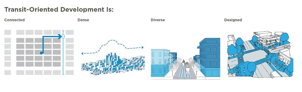
2 TOD Framework Connectivity: Expand transit access, increase mobility options Integrated system of pedestrian, bicycle, and auto facilities Density: Compact development Concentrate jobs, housing, shopping, and services close to transit Diversity: Locate a mix of transit serving uses, services, activities, and destinations conveniently near transit and limiting uses that only serve automobiles. Accommodating a range of ages, incomes, and lifestyle preferences, Connect transit to those who need it, and provide opportunities for those who use it. Design: Enhances the desirability of transit Provide a comfortable and inviting environment
3
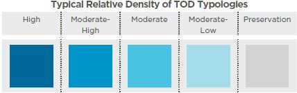
4 Typologies

5 Zoning for a Mix of Uses allow multiple uses in a district. Incentivizing Mixed Use Development incentive policy to focus on TOD locations Requiring Active Ground Floor Uses generate more pedestrian activity Limiting Incompatible Uses Prohibit uses that are not transit supportive Crafting a Housing Plan Establish a housing policy and affordability goals in TOD areas Promoting Housing Variety to accommodate diverse population Diversity Incentivizing Affordable Housing using available incentives in areas where affordable housing is needed. Requiring Affordable Housing in Designated Areas where affordable housing lacking Recognizing Historic Resources incent preservation and reuse Limiting Demolition Permits prevent irreversible or gratuitous demolitions. Recreational and Cultural Amenities Incorporate parks, public art, and other cultural facilities

6 Main Street Overlay Steering Committee Meeting #3 September 20, 2017


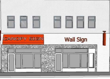
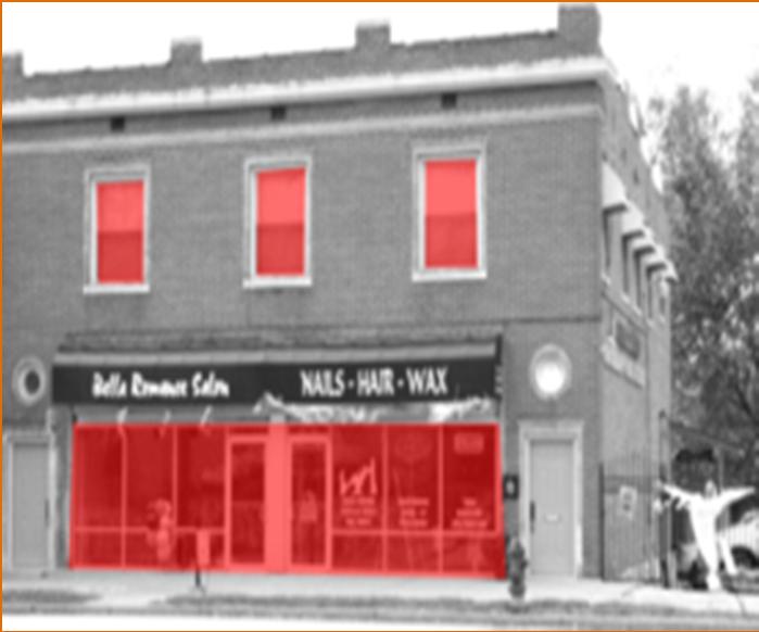
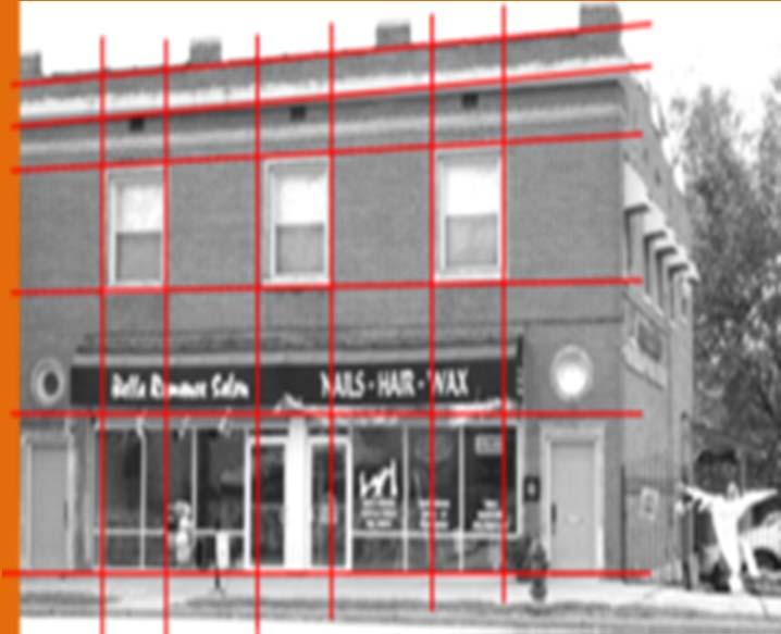
7 DESIGN STANDARDS SETBACKS & FRONTAGE MATERIALS TRANSPARENCY PARKING BUILDING FEATURES SIGNAGE 7

8
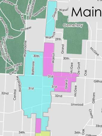
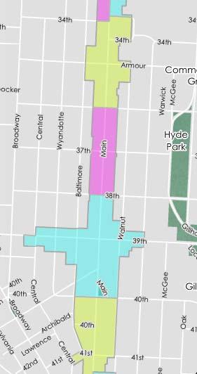
9 DESIGN STANDARDS Lot and Building Standards Transit Nodes Transit nodes are centered around a rapid transit stop. Transit nodes encourage an appropriate mixture of density and uses around rapid transit stops to increase ridership and support transit investments. These nodes are characterized by compact development that facilitates access between rapid transit stops and nearby residential, commercial, civic, recreational, and institutional uses. MINIMUM FLOOR AREA RATIO MINIMUM FRONTAGE MAXIMUM FRONT YARD SETBACK percent 0 feet MAXIMUM STREET-SIDE SETBACK 0 feet MINIMUM REAR YARD SETBACK Abutting nonresidential district: 0 feet Abutting residential: 15 feet for first 3 Stories. The fourth story and above shall be setback an additional 10 feet HEIGHT Minimum: 3 stories Maximum: 15 stories


10 Country Club/Waldo Area Plan What is an Area Plan? Most areas of the City have existing area plans. Previously 46 areas became out of date and layered. Now, 18 areas : 14 Complete 4 Underway


11 Walkability Recommendations Major and Collector Street Sidewalks Major Street Activity Center Collector Street Activity Center Park Construct Sidewalks On Major/Collector Streets In High Need Areas To Better Connect To Activity Centers/Transit No Sidewalks Sidewalks One Side Indicates Activity Center, Park or School Connection Indicates High Need Area


12 Pedestrian Connection Opportunities Major Street Collector Street Potential Pedestrian Connection Areas With Large Block Size Areas with Poor Street Connectivity Areas With Long Block Lengths
TRANSPORTATION FACILITIES AND THEIR IMPACT ON HEALTH
 TRANSPORTATION FACILITIES AND THEIR IMPACT ON HEALTH Health and Transportation Air quality Climate change Safety Physical activity Access to food, medical care, employment Policy Link & Prevention Institute
Planning Regionally With Transit
 Planning Regionally With Transit Nathan Coats Director of Operations CTAA Expo 2015 Tampa Began 1992. Serves eastern Cache County to Preston, ID. Population- 115,000 34 bus fleet, 26 fixed route buses;
CONNECTING PEOPLE TO PLACES
 CONNECTING PEOPLE TO PLACES 82 EAST BENCH MASTER PLAN 07 Introduction The East Bench transportation system is a collection of slow moving, treelined residential streets and major arteries that are the
ATTACHMENT 4 - TDM Checklist. TDM Checklist Overview
 ATTACHMENT 4 - TDM Checklist TDM Checklist Overview The proposed checklist rates developments on the degree to which they are TDM and transit supportive. Points are assigned based on the level of transit
Roanoke Valley TRANSIT VISION PLAN
 Roanoke Valley TRANSIT VISION PLAN Approved September 22, 2016 PART 6: Implementation Strategies and Performance Measures PART 6: Implementation Strategies 2 CONTENTS 1.0 OVERVIEW 4 2.0 TIMELINE 4 3.0
Stakeholder Meeting Handouts. January 2013
 January 2013 Stakeholder Meeting Handouts The Case FOR Parking Minimum Requirements Reduce street congestion around the development site Avoid parking spillover Create orderly development patterns Anticipate
Vision: Traditional hamlet with an attractive business/pedestrian friendly main street connected to adjacent walkable neighborhoods
 N D. Focus Area II Vision: Traditional hamlet with an attractive business/pedestrian friendly main street connected to adjacent walkable neighborhoods Transit Road Focus Area II is located in the Hamlet
Perryville TOD and Greenway Plan
 Perryville TOD and Greenway Plan Greenway Glossary Pathway: A bicycle and pedestrian path separated from motorized vehicular traffic by an open space, barrier or curb. Multi-use paths may be within the
Bicycle and Pedestrian Advisory Committee (BPAC) November 21, 2013
 November 21, 2013") Bicycle and Pedestrian Advisory Committee (BPAC) November 21, 2013 OVERALL LAND USE CONCEPT Overall Broadway Valdez District: 95.5 acres (35.1 acres right-of ways + 60.4 acres developable land) Plan Subareas:
Bicycle and Pedestrian Advisory Committee (BPAC) November 21, 2013 OVERALL LAND USE CONCEPT Overall Broadway Valdez District: 95.5 acres (35.1 acres right-of ways + 60.4 acres developable land) Plan Subareas:
Chapter 7. Transportation. Transportation Road Network Plan Transit Cyclists Pedestrians Multi-Use and Equestrian Trails
 Chapter 7 Transportation Transportation Road Network Plan Transit Cyclists Pedestrians Multi-Use and Equestrian Trails 7.1 TRANSPORTATION BACKGROUND The District of Maple Ridge faces a number of unique
JOINT PARTNERSHIPS: Working Together To Support Light Rail in Santa Monica
 JOINT PARTNERSHIPS: Working Together To Support Light Rail in Santa Monica ITY OF ANTA MONICA RAIL-VOLUTION / OCTOBER 17, 2012 SARAH LEJEUNE, PRINCIPAL PLANNER, STRATEGIC + TRANSPORTATION PLANNING DIVISION
Incentive Zoning. Zoning Ordinance Advisory Committee June 21, Pam Thompson, Senior Planner, Sustainable Development and Construction
 Incentive Zoning Zoning Ordinance Advisory Committee June 21, 2018 Pam Thompson, Senior Planner, Sustainable Development and Construction Presentation Overview Stakeholder questions Updated charts Design
Vision. Goals and Objectives. Walking
 Vision Walking and biking is an accepted and valued part of everyday life in Portsmouth. People of all ages and abilities include walking and biking as part of their daily activities which helps to make
Multimodal Through Corridors and Placemaking Corridors
 68 Multimodal Through Corridors and Placemaking Corridors Corridors have different functions in a region. Some corridors are used to get smoothly and rapidly through a region or to get quickly to major
S U B S T I T U T E O R D I N A N C E. WHEREAS, The City of Chicago has encouraged transit-oriented development since 2013; and
 S U B S T I T U T E O R D I N A N C E WHEREAS, The City of Chicago has encouraged transit-oriented development since 2013; and WHEREAS, Encouraging development around Chicago s transit assets both promotes
Illustrated Principles of Good Planning
 Illustrated Principles of Good Planning The Miami 21 Zoning Code incorporates time-tested planning principles into the zoning regulations of our City. These are principles that make for better neighborhoods,
Corridor Vision Workshop Summary James Madison Elementary February 22,2018
 Corridor Vision Workshop Summary James Madison Elementary February 22,2018 WHY DEVELOP THIS STUDY? Ogden City is planning for better connectivity and access to jobs and housing. Working with area partners,
EXECUTIVE SUMMARY: TRANSIT-ORIENTED DEVELOPMENT IN SMITHS FALLS, ONTARIO; A COMPARISON BETWEEN TWO SITES
 EECUTIVE SUMMARY: TRANSIT-ORIENTED DEVELOPMENT IN SMITHS FALLS, ONTARIO; A COMPARISON BETWEEN TWO SITES Topic and Purpose In 2007, the Mayor of Ottawa s Task Force on Transportation suggested adding a
Age Friendly Communities Idea Exchange
 Englewood: Englewood is a small, comfortable community just south of Denver with a diverse population of 30,255. Englewood's central location in the Denver Metropolitan area and handy access via highways
Cherry Creek Transportation and Land Use Forum September 25, 2013 Meeting Summary
 Cherry Creek Transportation and Land Use Forum September 25, 2013 Meeting Summary I. LEAD-IN TO SMALL GROUP DISCUSSION, POLLING AND STEERING COMMITTEE/TECHNICAL TASK FORCE DISCUSSION The meeting began
Northside Livable Centers Study
 Northside Livable Centers Study Advisory Committee Meeting #2 Preferred Conceptual Plan March 2, 2010 AGENDA FOR ADVISORY COMMUNITY WORKSHOP #1 Project Overview and Timeline Planning Area Overview Workshop
CONTEXT SENSITIVE STREETS STANDARDS COMMITTEE
 CONTEXT SENSITIVE STREETS STANDARDS COMMITTEE February 23, 2015 Prepared by: Denise Chaplick, AICP City Jacksonville Bicycle and Pedestrian Coordinator Source: NCDOT Complete Streets Planning and Design
COMMUNITY WORKSHOP #2 DOWNTOWN CONCORD SPECIFIC PLAN
 COMMUNITY WORKSHOP #2 Timeline 21-month process Tasks 1-3; Basis for the preparation of the plan (Jan. through March) Tasks 4-5; Development and Evaluation of Alternatives. Selection of Preferred Alternative.
summary of issues and opportunities
 1 summary of issues and opportunities EXECUTIVE SUMMARY CHAPTER 2: HISTORY - 3: LAND USE This first chapter is an overview of lessons learned from analysis of the existing conditions on El Camino as well
METRO RTA TRANSIT MASTER PLAN. May 25-26, 2011
 METRO RTA TRANSIT MASTER PLAN May 25-26, 2011 WHAT IS THE TRANSIT MASTER PLAN? A twenty-year plan for METRO RTA What will METRO look like in 2031? 1 TRANSIT TECHNOLOGIES 2 TRANSIT TECHNOLOGIES Transit
Access BART: TOD and Improved Connections. October 29, 2008
 Access BART: TOD and Improved Connections October 29, 2008 1 Access BART Study Goals Evaluate at the system-level land use and access scenarios to optimize ridership Identify station clusters that provide
Brian D. Hare, P.E. Bureau of Design PennDOT PA APA Annual Conference Investing in a Sustainable Future October 5, 2009
 Brian D. Hare, P.E. Bureau of Design PennDOT 2009 PA APA Annual Conference Investing in a Sustainable Future October 5, 2009 1 What is Smart Transportation? Photographer: heyjude. Used through license
Metro Nashville Sidewalk Requirements. Section (Provision of sidewalks) Effective July 1, 2017
 Effective July 1, 2017") Metro Nashville Sidewalk Requirements Section 17.20.120 (Provision of sidewalks) Effective July 1, 2017 Why are sidewalks a critical priority? Lack of requirements from 1950s to 1990s NashvilleNext, nmotion,
Metro Nashville Sidewalk Requirements Section 17.20.120 (Provision of sidewalks) Effective July 1, 2017 Why are sidewalks a critical priority? Lack of requirements from 1950s to 1990s NashvilleNext, nmotion,
The Naples Park Community Plan DRAFT- MARCH 2003
 The Naples Park Community Plan DRAFT- MARCH 2003 prepared by: Dover, Kohl & Partners Town Planning Agnoli, Barber, & Brundage, Inc. Drainage Analysis Hall Planning and Engineering Transportation Planning
The best indicator of an individual s and expanding access to parks and open space.
 Health & Wellness Create a Safe and Healthy Built Environment Artist s rendering, 2014 Health is important to Loveland residents, and stakeholders see the many strong connections between quality of life,
o n - m o t o r i z e d transportation is an overlooked element that can greatly enhance the overall quality of life for the community s residents.
 N o n - m o t o r i z e d transportation is an overlooked element that can greatly enhance the overall quality of life for the community s residents. 84 Transportation CHAPTER 11 INTRODUCTION Transportation
Richmond Connects Visioning Update
 Richmond Connects Visioning Update To date there have been four elements of the visioning process: Vision20 Night at Byrd Theatre on May 3rd Advisory Committee Meeting on May 12 th Public Visioning Workshop
Ann Arbor Downtown Street Plan
 1 Ann Arbor Downtown Street Plan Public Workshop #1 We know that. 2 Public right-of-way (streets, sidewalks, and alleys) make up 30% of the total District area of downtown. Streets need to provide mobility
Overview: Phase 3 Draft Development and Circulation Plans, White Bear Station
 Overview: Phase 3 Draft Development and Circulation Plans, White Bear Station This overview explains how to get more involved and provides information on the Phase 3 draft circulation and development plans
Market Factors and Demand Analysis. World Bank
 Market Factors and Demand Analysis Bank Workshop and Training on Urban Transport Planning and Reform. Baku, April 14-16, 2009 Market Factors The market for Public Transport is affected by a variety of
Arapahoe Square Zoning + Design Standards & Guidelines Task Force Meeting 9 January 27, 2016
 Arapahoe Square Zoning + Design Standards & Guidelines Task Force Meeting 9 January 27, 2016 Agenda 3:00 Opening/Welcome 3:15 Touch Base on Schedule and Milestones Moving Forward 3:20 Review the Overall
ACTIVE TRANSPORTATION
 ACTIVE TRANSPORTATION Mobility 2040 Supported Goals Improve the availability of transportation options for people and goods. Support travel efficiency measures and system enhancements targeted at congestion
Linking Transportation and Health in Nashville & Middle Tennessee
 Linking Transportation and Health in Nashville & Middle Tennessee Fit Nation New Orleans CPPW Mentoring Grant Built Environment Program May 14, 2011 Local Transportation Planning Framework Federal U.S.
Approaches. Livable Neighborhood Design. Examples. Traditional neighborhood development. CE 594 University of Wisconsin- Milwaukee
 Approaches Livable Neighborhood Design CE 594 University of Wisconsin- Milwaukee Traditional neighborhood design (TND), new urbanism, transit friendly design, transit oriented development and walkable
Comments The Plan for Port Whitby
 Comments The Plan for Port Whitby April 24th, 2013 Community Meeting #2 Summary Report Prepared by GLPi April 29th, 2013 1 Introduction The purpose of the Port Whitby Secondary Plan Update, Community Improvement
Table #6 VISION CHARACTERISTICS
 Table #6 VISION White Flint is a place to live, work, play, shop, and walk with sufficient density to encourage quality redevelopment. Vibrant streets and consistent streetscapes are important. CHARACTERISTICS
NEWMARKET UPHAM S CORNER
 SOUTH STATION Planning Initiative NEWMARKET UPHAM S CORNER COLUMBIA ROAD (P) FOUR CORNERS/GENEVA Working Advisory Group (WAG) Meeting #5 TALBOT AVENUE MORTON STREET BLUE HILL AVE/CUMMINS HWY (P) RIVER
What Are The Benefits? How RIDERSHIP + Can Help You. Select RIDERSHIP + Projects
 Ridership + is a suite of regression-based direct ridership forecasting tools that harness station area built environment variables to estimate ridership on a wide variety of transit modes. What Are The
Strategic Plan for Active Mobility Phase I: Bicycle Mobility
 Strategic Plan for Active Mobility Phase I: Bicycle Mobility City of Corpus Christi February 9, 2016 Jeff Pollack, AICP Transportation Planning Director Vision Active Mobility Plan Vision The metropolitan
Chapter VISION, MISSION, AND GOALS AND OBJECTIVES. Vision. Mission. Goals and Objectives CONNECTING COMMUNITIES ACROSS THE ST.
 VISION, MISSION, AND GOALS AND OBJECTIVES Chapter 3 The Plan s vision, mission, and goals and objectives were developed through a series of interactive exercises with the Citizens Advisory Committee (CAC)
Multimodal Transportation Plan
 Multimodal Transportation Plan The Multimodal Transportation Plan will accommodate MILLENIALS ARE DRIVING LESS. WE CANNOT BUILD OUR WAY all modes of transportation by keeping pedestrians, OUT OF CONGESTION.
Presentation Comments and Questions
 Presentation Comments and Questions The community had a number of questions regarding the master plan process and operational issues in and around the MARC rail station areas. The bullet points below are
VI. Market Factors and Deamnd Analysis
 VI. Market Factors and Deamnd Analysis Introduction to Public Transport Planning and Reform VI-1 Market Factors The market for Public Transport is affected by a variety of factors No two cities or even
TECHNICAL MEMORANDUM 3: EXISTING CONDITIONS ANALYSIS FOR THE VILLAGE GREEN MULTIMODAL TRANSPORTATION DISTRICT
 TECHNICAL MEMORANDUM 3: EXISTING CONDITIONS ANALYSIS FOR THE VILLAGE GREEN MULTIMODAL TRANSPORTATION DISTRICT Prepared for: TREASURE COAST REGIONAL PLANNING COUNCIL Prepared by: RENAISSANCE PLANNING GROUP
City of Walnut Creek TELEGRAPH AVENUE BART LINE SELF-GUIDED TOD TOUR 19TH STREET BART STATION
 TELEGRAPH AVENUE City of Walnut Creek BART LINE SELF-GUIDED TOD TOUR 19TH STREET BART STATION Self-Guided TOD Tour With the Walnut Creek BART Station located squarely within its boundaries, the West Downtown
City of Novi Non-Motorized Master Plan 2011 Executive Summary
 City of Novi Non-Motorized Master Plan 2011 Executive Summary Prepared by: February 28, 2011 Why Plan? Encouraging healthy, active lifestyles through pathway and sidewalk connectivity has been a focus
AND GUIDING PRINCIPLES. Boise, Idaho 1997
 USTICK CONCEPT MASTER PLAN AN AND GUIDING PRINCIPLES Boise City Comprehensiv ehensive e Plan Boise, Idaho 1997 GOALS, OBJECTIVES AND POLICIES BOISE CITY ~ NEIGHBORHOOD MASTER PLANS USTICK CONCEPT MASTER
Eliminate on-street parking where it will allow for a dedicated bus only lane %
 Traffic Dashboard Priorities Survey Responses Introduction 1) Are you familiar with bus rapid transit (BRT)? a. No, BRT is new to me. 597 23.5% b. I ve heard of BRT, but I don t know much about it. 1,136
TRANSPORTATION ASSESSMENT
 TRANSPORTATION ASSESSMENT Traffic Modeling The mobility findings analysis for Dallas was based on the methodology of the North Central Texas Council of Government s Regional travel demand model. This model
Vision. cultural identity, income group, neighborhood identity, or mobility level. Rendering by Robin Chiang
 Vision Rendering by Robin Chiang The will result in a street system designed to promote human needs for the use and enjoyment of these public spaces by all. It will prioritize the needs of walking, bicycling,
Goal 3: Foster an environment of partnerships and collaboration to connect our communities and regions to one another.
 Non-Motorized Transportation Plan (NMTP) Draft Vision, Goal and,, Tri-County Regional Planning Commission (TCRPC) Purpose The purpose of the Tri-County Regional Planning Commission (TCRPC) Non-Motorized
162 RESIDENTS ATTENDED 2 DAYS OF WORKSHOPS 15 TABLE DISCUSSIONS WHAT WE HEARD. Oakridge Municipal Town Centre Workshops PLANNING PROGRAM
 OAKRIDGE MTC WORKSHOP 2017 CAMBIE CORRIDOR Phase 3 STEP 3: 3: October June 2017 CAMBIE CORRIDOR PLANNING PROGRAM 2 DAYS OF WORKSHOPS 15 TABLE DISCUSSIONS 162 RESIDENTS ATTENDED WHAT WE HEARD Oakridge Municipal
Regional Transportation Needs Within Southeastern Wisconsin
 Regional Transportation Needs Within Southeastern Wisconsin #118274 May 24, 2006 1 Introduction The Southeastern Wisconsin Regional Planning Commission (SEWRPC) is the official areawide planning agency
Pocatello Regional Transit Master Transit Plan Draft Recommendations
 Pocatello Regional Transit Master Transit Plan Draft Recommendations Presentation Outline 1. 2. 3. 4. What is the Master Transit Plan? An overview of the study Where Are We Today? Key take-aways from existing
Good TOD. July 7, 2016 SPUR
 Good TOD July 7, 2016 SPUR Caltrain TOD Context: Growing Demand For Service Extraordinary Ridership Growth Projected Continued Growth High Speed Rail Service on the Peninsula Increasing Land Use Intensities
6. Traditional Neighborhood Design. Fact Sheet
 6. Traditional Neighborhood Design Fact Sheet What is Traditional Neighborhood Design? Traditional Neighborhood Design (TND) is a planning concept that calls for residential neighborhoods to be designed
Transport Interchange as city centres of activity. Planning approach Case Study Naya Raipur Chhattisgarh, India. Winter University 2015 IRKUTSK
 Transport Interchange as city centres of activity Planning approach Case Study Naya Raipur Chhattisgarh, India Winter University 2015 IRKUTSK Dilip Shekdar Architect and Planner, Consultant Naya Raipur
Existing Pedestrian Conditions. PSAC February 8, 2011
 Existing Pedestrian Conditions PSAC February 8, 2011 Contents 1. Project Background & Goals 2. Pedestrian Activity: Where people walk 3. Pedestrian Safety: The conditions people face Project Background
CITY OF COCOA BEACH 2025 COMPREHENSIVE PLAN. Section VIII Mobility Element Goals, Objectives, and Policies
 CITY OF COCOA BEACH 2025 COMPREHENSIVE PLAN Section VIII Mobility Element Goals, Objectives, and Policies Adopted August 6, 2015 by Ordinance No. 1591 VIII MOBILITY ELEMENT Table of Contents Page Number
Chapter 5 Planning & Zoning
 Paoli Road Improvement Feasibility Study and Public Participation Project Chapter 5 Planning & Zoning Evaluation 5.1 The Vision for Paoli 2 5.1A Great Streets 3 5.1B Improve Paoli s Intersections & Blocks
SETTINGS AND OPPORTUNITIES MOBILITY & ACCESS
 7 mobility & access how do people use el camino what is it like to drive on el camino/to park along el camino what is the pedestrian experience like what is the role of transit along the corridor what
Executive Summary Route 30 Corridor Master Plan
 Route Corridor Master Plan Project Overview The Route Corridor Master Plan is a coordinated multimodal transportation and land use plan for the entire stretch of Route through East Whiteland Township,
Item to be Addressed Checklist Consideration YES NO N/A Required Description Complete Streets Guidelines
 Passaic County Complete Streets Checklist - Concept Development Project Name Item to be Addressed Checklist Consideration YES NO N/A Required Description Complete Streets Guidelines Existing Plans Have
Arlington s Master Transportation Plan
 Arlington s Master Transportation Plan The Master Transportation Plan (MTP) Adopted in eight parts Goals & Policies element and MTP Map adopted in 2007 Bicycle, Pedestrian and Demand and Systems Management
SECTION 1 - TRAFFIC PLANNING
 SECTION 1 - TRAFFIC PLANNING 1.1 TRAFFIC OPERATIONS 1.1.1 Roadway Functional Classification The Multnomah County Comprehensive Framework Plan s Policy 34: Trafficways and the Functional Classification
About the Active Transportation Alliance
 About the Active Transportation Alliance Chicagoland s voice for better biking, walking and transit Founded 1985 7,000 members, ~33 full time staff Serve Chicago metro region 1 More Cars, More Driving
REGIONAL BICYCLE AND PEDESTRIAN DESIGN GUIDELINES
 REGIONAL BICYCLE AND PEDESTRIAN DESIGN GUIDELINES November 16, 2011 Deb Humphreys North Central Texas Council of Governments Bicycle and Pedestrian Advisory Committee Snapshot of the Guide 1. Introduction
Implementing Living Streets. Dena Belzer January 29, 2009
 Implementing Living Streets Dena Belzer January 29, 2009 February 22, 2004 Starting with Some Definitions 1.Living Streets/Complete Streets 2.Corridor Revitalization 3.Shopping Mall Reuse Living/Complete
12/13/2018 VIA
 12/13/2018 VIA EMAIL Daniel Abbes, Assistant Planner City of Sacramento community Development Department 300 Richards Blvd., 3 rd Floor Sacramento, CA 95811 RE: Bruceville Apartments (P18-073) Dear Mr.
Advanced Transit Oriented Developments (ATODs) - Defined
 - Defined") Advanced Transit Oriented Developments (ATODs) - Defined Work previously undertaken at Florida International University (FIU) in the Lehman Center for Transportation Research (LCTR), the School of Architecture
Advanced Transit Oriented Developments (ATODs) - Defined Work previously undertaken at Florida International University (FIU) in the Lehman Center for Transportation Research (LCTR), the School of Architecture
GUIDE TO. Transit Supportive Land Use
 GUIDE TO Transit Supportive Land Use INTRODUCTION Defines transit supportive land use, VIA s Vision for transit in San Antonio, and the purpose and use of these guidelines. BENEFITS OF TRANSIT-SUPPORTIVE
CITY OF BLOOMINGTON COMPLETE STREETS POLICY
 CITY OF BLOOMINGTON COMPLETE STREETS POLICY POLICY OBJECTIVE: The City of Bloomington will enhance safety, mobility, accessibility and convenience for transportation network users of all ages and abilities,
Chapter 2. Bellingham Bicycle Master Plan Chapter 2: Policies and Actions
 Chapter 2 Bellingham Bicycle Master Plan Chapter 2: Policies and Actions Chapter 2: Policies and Actions The Bicycle Master Plan provides a road map for making bicycling in Bellingham a viable transportation
5 CIRCULATION AND STREET DESIGN
 5 CIRCULATION AND STREET DESIGN This chapter describes circulation and streetscape improvements proposed for the Northwest Chico Specific Plan Area. It includes detailed design specifications for existing
5. Pedestrian System. Accomplishments Over the Past Five Years
 5. Pedestrian System Accomplishments Over the Past Five Years The Alamo Area Metropolitan Planning Organization (MPO) and its partner agencies recognize the importance of improving pedestrian mobility.
Anniedale- Tynehead NCP Best Practices in Transportation Planning Summary
 Anniedale- Tynehead NCP Best Practices in Transportation Planning Summary The City of Surrey Anniedale-Tynehead NCP Best Practices Transportation Summary This document provides a summary of the Bunt &
Pathways to a Healthy Decatur
 CHAPTER 1 Pathways to a Healthy Decatur Health is a holistic sense of spiritual, mental, and physical well-being and the absence of illness and disease - a compilation of definitions of health by community
Appendix A-1: Purpose and Need Statement
 Appendix A-1: Purpose and Need Statement PURPOSE AND NEED STATEMENT Western & Ashland Corridors Bus Rapid Transit (BRT) Project Prepared for Chicago Transit Authority 567 West Lake Street Chicago, IL 60661
4 MOBILITY PLAN. Mobility Plan Objectives. Mobility Context. 1. Integrate with Local and Regional Transit Improvements
 Harbor Mixed Use CHAPTER Transit Corridor 4: Mobility Plan 4 MOBILITY PLAN Mobility Plan Objectives The Harbor Corridor Plan seeks to expand and improve the ways that people move along and through the
NOTES FROM JUNIOR COUNCIL ORIENTATION SESSION HELD ON MONDAY, JANUARY 22, 2018, AT 3:30 PM IN COUNCIL CHAMBERS, CITY HALL
 CITY OF KAMLOOPS Junior Council Meeting Agenda March 12, 2018, at 3:30 pm in Council Chambers, 7 Victoria Street West, Kamloops, BC Page 1. APPROVAL OF THE AGENDA 2. MINUTES Attachment Recommendation:
City of Decatur, GA. Speed Limits Study and Proposal
 City of Decatur, GA Speed Limits Study and Proposal Table of Contents SUMMARY 2 HEALTH IMPACTS 5 EXAMPLES 6 ASSESSMENT 7 Current Speed Limits 7 Safe Routes To School 9 Speed Limit Enforcement 11 Accidents
APPENDIX A: Complete Streets Checklist DRAFT NOVEMBER 2016
 APPENDIX A: Complete Streets Checklist DRAFT NOVEMBER 2016 Complete Streets Checklist MetroPlan Orlando s Complete Streets Checklist is an internal planning tool for staff to further implementation of
Shared Court Housing Concept Summary
 January 20, 2006 Shared Court Housing Concept Summary Zoning Code Definition (adopted 12/21/05) Shared Court. A street that is designed to accommodate within the same circulation space access for vehicles,
University of Michigan & Urban Land Institute Real Estate Forum. Mary Beth Graebert Michigan State University
 University of Michigan & Urban Land Institute Real Estate Forum Mary Beth Graebert Michigan State University November 20, 2013 Michigan State University Land Policy Institute Strong focus on research and
95 th Street Corridor Transportation Plan. Steering Committee Meeting
 95 th Street Corridor Transportation Plan Steering Committee Meeting August 11, 2014 PROJECT OBJECTIVES Develop a Transportation and Economic Plan for the 95 th Street Corridor Improve public transit efficiency
Transportation 6. A. Transit Center Circulation and Access. 1. Transit Center Circulation
 Transportation 6 This chapter describes the transportation system in and around the Hillsdale Station Area, with a focus on the Transit Center at the relocated Hillsdale Caltrain Station. The transportation
complete streets design and construction standards public primer City of Edmonton
 complete streets design and construction standards public primer City of Edmonton introduction Complete Streets are streets for everyone: people who walk, wheel, bike, take transit, or drive. They are
Livable Community Principles City of North Las Vegas, Nevada June, 2005 Dan Burden, Glatting Jackson and Walkable Communities, Inc.
 Livable Community Principles City of North Las Vegas, Nevada June, 2005 Dan Burden, Glatting Jackson and Walkable Communities, Inc. What is the Purpose of Cities? 1 Dan has learned to see the world through
Exhibit 1 PLANNING COMMISSION AGENDA ITEM
 Exhibit 1 PLANNING COMMISSION AGENDA ITEM Project Name: Grand Junction Circulation Plan Grand Junction Complete Streets Policy Applicant: City of Grand Junction Representative: David Thornton Address:
Planning Cities for People. A Guide to Prosperous, Low-Carbon Urbanization
 Planning Cities for People A Guide to Prosperous, Low-Carbon Urbanization The world s next generation of cities will need to overcome extreme challenges posed by population growth, congestion, and energy
Designing Healthier Environments to Conquer Disease Epidemics: Successes in NYC and Elsewhere. Karen K. Lee, MD, MHSc
 Designing Healthier Environments to Conquer Disease Epidemics: Successes in NYC and Elsewhere Karen K. Lee, MD, MHSc Can Design Help Address Today s Health Epidemics? THE 19th CENTURY: Infectious Diseases
Bicycle-Pedestrian Master Plan Update
 Bicycle-Pedestrian Master Plan Update Planning & Zoning Commission November 29, 2017 Overview Project Purpose & Scope Project History Plan Vision & Goals Chapter 5: Making Connections-Beyond the Path Next
and Rural Multimodal Networks 2017 ALTA PLANNING + DESIGN
 Small Town and Rural Multimodal Networks 2017 ALTA PLANNING + DESIGN SMALL TOWN AND RURAL MULTIMODAL NETWORKS GUIDE Why a Rural and Small Town Focused Guide? ONE SIZE DOES NOT FIT ALL. The new FHWA-endorsed
15 April CAMPUS MASTER PLAN UPATE F o c us G r o up M o b ility
 15 April 2016 CAMPUS MASTER PLAN UPATE F o c us G r o up M o b ility AGENDA What We Heard Campus Framework & Open Space Network Mobility Approach Supporting the Pedestrian Environment Mobility & Sustainability
TORONTO WALKING STRATEGY
 CITY OF TORONTO t TORONTO WALKING STRATEGY EVERYONE IS A PEDESTRIAN ItitiORONM TORONTO MAYOR DAVID MILLER Toronto's Walking Strategy is a vision for a more liveable, prosperous and sustainable city. It