Intersection Improvement Study Nixon, Green, and Dhu Varren Roads
|
|
|
- Dora Fitzgerald
- 5 years ago
- Views:
Transcription


1 City of Ann Arbor Intersection Improvement Study Nixon, Green, and Dhu Varren Roads `


2
3 i Contents 1 Introduction Study Location Purpose of Study and Scope Background Information Traffic Volumes (Existing and Predicted) Concept Development Preliminary Concepts Operational Analysis Concept Refinement Concept Evaluation Operations Cost Estimates Right-of-way Needs Pedestrian and Cyclist Accommodations Transit Accommodations Safety Influences Environmental Impacts Community Engagement Summary Selection of Preferred Option Recommendation... 23


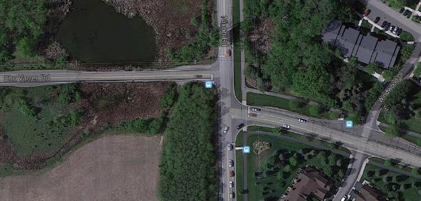
4 1 1 Introduction The City of Ann Arbor (the City) retained (Opus) to perform an intersection improvement study at the intersection of Dhu Varren Road, Green Road, and Nixon Road. The primary goal of this study is to identify an intersection configuration that would improve capacity and operational efficiency in addition to: Improve pedestrian, bicycle, and vehicular safety; Create a pedestrian-friendly environment; Accommodate bicycle traffic; Provide accessibility for the disabled in accordance with applicable ADA requirements; and, Minimize environmental impacts to wetlands and other natural features. 1.1 Study Location The intersection of Dhu Varren Road, Green Road, and Nixon Road is currently an all-way stopcontrolled intersection with offset eastbound-westbound approaches. The intersection configuration is unique requiring drivers to make internal maneuvers to complete their movements through the intersection, particularly for eastbound and westbound through movements. The offset is approximately 50 feet wide which contributes to increased delay and safety concerns. The intersection is located in the north end of Ann Arbor between Plymouth Road and US-23/M-14 in a mostly residential area. An aerial image of the study location is shown in Figure 1. Figure 1: Study Location

 and through lanes in each direction. The TWLTL turns into a left turn lane at the intersection.")
5 2 Dhu Varren Road is a two lane facility approaching from the west, with no turning lanes at the intersection. It has bike lanes in some locations, overhead utility poles, underground utilities, and a posted speed limit of 35 mph. The land to the north and south of Dhu Varren Road is currently undeveloped, and contains several environmental features, i.e., wetlands and landmark bur oak tree. Green Road is a three lane roadway with a two-way-left-turn-lane (TWLTL) and through lanes in each direction. The TWLTL turns into a left turn lane at the intersection. The existing corridor has sidewalks on both sides, bike lanes, bus stops, and a variety of underground services and utilities. There is currently residential development north and south of Green Road, as well as an environmentally sensitive area to the immediate north. Nixon Road is predominantly a two-lane roadway connecting Huron Parkway and Plymouth Road towards the south to rural areas north of the City. It has a sidewalk on the east side, bike lanes on both sides, bus stops, and a mix of above ground and underground utilities. The road has a mix of 30 and 35 mph speed limits in the project area. Three future developments are to be located adjacent to the study intersection, as shown in Figure 2. The figure also helps show the intersection alignment and environmental features discussed above. Figure 2
6 3 1.2 Purpose of Study and Scope The lands in the north-west and south-west quadrants of the intersection are being proposed for residential development. As a result, the current intersection configuration may not be sufficient to accommodate future traffic demands. This, combined with existing public concern regarding the current configuration, has prompted the City of Ann Arbor to retain Opus to undertake an analysis of potential improvement options. As detailed in Section 2 of this report, eight concepts have been considered and analyzed. An operational analysis was conducted for each of the concepts based on projected traffic volumes. This section also identifies the refinement process, where three concepts were chosen to be further analyzed. The two concepts chosen to be further analyzed have been compared in Section 3 with the preferred concept recommended in Section 4. The recommended configuration addresses a variety of factors including road user safety, accommodation of pedestrians and cyclists, accessibility for the disabled, construction cost, and impact on the surrounding wetlands. 1.3 Background Information The study location has been included in many traffic impact studies, including some that are ongoing. On October 9, 2013, the City held a public information meeting to gather information regarding the study intersection. The discussion summary of the meeting in addition to background documents have been reviewed as part of this study. Background documents include, but are not limited to the following: Washtenaw Area Transportation Study provided at City of Ann Arbor Master Plan: Land Use Element (November 5, 2009); Non-motorized Transportation Plan and Review (2007 & 2013); City of Ann Arbor FY Capital Improvements Plan (2011); City of Ann Arbor Green Streets Policy Statement (February 18, 2014); Previously completed traffic impact studies; o Woodbury Club Development (July 9, 2013) o Proposed Nixon Property Condominiums (July 2014) Standard Specifications Book (current website version); Crash data from the Michigan Traffic Crash Facts website; and, Photos and Maps of the study area, including utilities, land use, zoning, and speed limit maps. 1.4 Traffic Volumes (Existing and Predicted) A detailed summary of traffic volume assumptions are provided in Appendix A. The existing traffic volumes, shown in Figure 3, were gathered from the Nixon Property Condominium Traffic Impact Study, which have been approved by the City. These volumes were used to analyze the existing operations of the intersection detailed in Section 2 of this report.
7 4 Turning Movements with Offset Configuration Figure 3: Existing Traffic Volumes To determine projected 2035 traffic volumes, background traffic growth volumes and future generated traffic volumes were added to the existing traffic volumes. Background traffic growth was provided by the Washtenaw Area Transportation Study (WATS). Future generated traffic volumes included seven developments. For the three closest developments (see Figure 2), existing traffic impact studies approved by the City were used to determine the future traffic impacts to the study intersection. For the remainder of the developments, future traffic volumes were generated based on the trip generation rates and directional (inbound and outbound) distributions published in the Trip Generation, 9th Edition, 2012, by the Institute of Transportation Engineers. Information provided by the City about the potential future developments, WATS directional movement assumptions, and traffic impact studies under review, were used to determine the future traffic impacts to the intersection. The projected year 2035 traffic volumes, that include background traffic and future generated traffic, is shown in Figure 4. These volumes were used to analyze future operations for each of the concepts.
8 5 Turning Movements with Aligned Configuration Turning Movements with Offset Configuration Figure 4: Projected Traffic Volumes (2035)
9 6 2 Concept Development 2.1 Preliminary Concepts A variety of concepts were considered ensuring a thorough review leading to the most appropriate solution. In addition to the existing/status quo concepts (Concepts 0-1), seven base concepts (Concepts 2-8) were analyzed operationally. Some of the base concepts consisted of sub-categories that were designed to operate effectively and then analyzed. Below is a list of the different concepts that were analyzed. Section 2.2 summarizes the results of the operational analyses. Concepts: 0. Existing- Existing operations analyzed with 2014 turning movement counts (Figure 3). 1. Status quo Leave as is - Future operations within the existing intersection configuration. 2. Two-way stop control- Conversion to stop control on the east and west approaches only. 3. Aligned all-way stop control- Realignment of Dhu Varren Road and maintaining the all-way stop control 4. Offset signal- Conversion to a signalized intersection and maintaining the offset tee layout for the following two sub-categories: a. Existing lane configuration b. Modified lane configuration 5. Aligned signal- Conversion to a signalized intersection and realigning Dhu Varren Road. 6. One lane roundabout- Conversion to a roundabout and realigning of the east and/or west approaches. 7. Oval roundabout- Conversion to an oval shaped roundabout and maintaining the offset east and west road alignments. 8. One lane roundabout with bypass- Conversion to a one lane roundabout with a right-turn bypass lane on the eastbound approach.
10 7 2.2 Operational Analysis An operational analysis was undertaken for each of the intersection concepts identified in Section 2.1 to determine existing and future performance. Intersection performance was evaluated by calculating the Levels of Service (LOS) as defined in the Highway Capacity Manual 1 and summarized in Table 1. To evaluate the unsignalized/signalized concepts, Synchro plus SimTraffic 8 software was used. Although SimTraffic software can also be used to model roundabouts, the accuracy of the results are not consistent. Therefore, Sidra Intersection 6 was used to evaluate the roundabout concepts. Sidra is an analytical model which has been proven to predict accurate delay for one-lane roundabouts in the U.S. 2 As the results of the Sidra analysis were reported using the HCM 2010 methodology, for consistency, concepts analyzed by SimTraffic (i.e. Concept 5), were also reported using the HCM methodology in Synchro. It is important to note that although the traffic models used to evaluate the unsignalized/signalized concepts and the roundabout concepts are different, they can be used to assess acceptable LOS to meet future demands, and they give an indication of queuing requirements. However, this tool is not the only consideration when comparing various types of intersections. In the next section, other parameters such as safety and cost are considered along with traffic models to help in the preferred decision making process. LOS Brief Description Table 1: LOS Criteria Delay per vehicle (seconds) Unsignalized Intersection or Roundabout Signalized Intersection A Represent excellent operation with B minimal or no delays. >10-15 >10-20 C Typical operating levels when some >15-25 >20-35 D delays occur. >25-35 >35-55 E Congested situations and improvements >35-50 >55-80 F are usually considered at these levels. >50 >80 SimTraffic Simulation is useful for analyzing complex situations, such as this one where the intersection consists of offset legs. Therefore, the delay from SimTraffic Simulation was used to define the LOS for concepts one (1) through five (5) which are summarized in Table 2 to 6. The results consisted of an average of five (5) simulation runs to smooth out the randomness that is inherent in the simulations. The SimTraffic results were also compared to the Synchro HCM 2010 results. In some instances the delay in SimTraffic was slightly longer than the delay identified in the Synchro HCM 2010 results, which 1 HCM 2010 Highway Capacity Manual, Volume 3: Interrupted Flow. Washington, DC: Transportation Research Board of the National Academies, December Flannery, A., L. Elefteriadou, P. Koza, and K. McFadden. Safety, delay and capacity of single-lane roundabouts in the United States. Washington, DC: Transportation Research Board, National Research Council, 1998.
11 8 is apparent in Concept 5. The HCM results for Concept 5 are also detailed in Table 6 and were used for comparison purposes during the concept evaluation. In the City s 2009 Transportation Plan Update, the desired intersection LOS is identified as C or better. However, it has been suggested that the standard be reconsidered as LOS D or better, particularly for urban locations. It was agreed with the City that LOS D or better would be an acceptable LOS for this study intersection. Concept 0. Existing (2014) 1. Status quo Leave as is (2035) Table 2: Calculated Level of Service (Concept 0 & 1) AM Peak PM Peak Delay Delay Approach LOS (s/veh) (s/veh) LOS EB Shared Left/Right 61.3 F 7.7 A WB Designated Left, 32.2 D 23.7 C Designated Right NB Shared Thru/Right 41.2 E F SB Shared Thru/Right F 12.7 B Overall 98.3 F 74.7 F EB Shared Left/Right F 10.2 B WB Designated Left, Designated Right 40.6 E 31.9 D NB Shared Thru/Right F F SB Shared Thru/Right F 13.9 B Overall F F Concept 0: Represents current operations in In developing this model it was necessary to adjust the settings within the model to accurately reflect existing operations. The staggered arrangement of Dhu Varren and Green Roads creates hesitancy and additional delays compared to a conventional fourway stop arrangement. As shown in Table 2, many of the approaches operate at an unacceptable LOS during the AM and PM peak hours. These results depict the current intersection operations during the AM and PM peak hours and are consistent with observations made at the site during a peak period situation. Current intersection operations result in a 98 s/veh (second per vehicle) average delay in the AM peak hour, and a 75 s/veh average delay in the PM peak hour. Concept 1: Represents the existing intersection configuration and operations in year 2035 which takes into account the additional traffic growth expected in the area. As shown in Table 2, all movements experience increased delay, which impacts overall intersection LOS during both the AM and PM peak hours. The results indicated a LOS F with overall intersection average delays of 366 s/veh for the AM peak, and 283 s/veh for the PM peak. As stated in the 2009 Transportation Plan, Any intersection projected to operate worse than LOS D will have mitigation measures recommended. Since the existing intersection configuration and operations would result in undesirable delay in the future, Concepts 2-8 were modeled to identify potential concepts that would provide acceptable operations in the future.
12 9 Concept 2. Two-way stop control (2035) Table 3: Calculated Level of Service (Concept 2) AM Peak PM Peak Delay Delay Approach LOS (s/veh) (s/veh) LOS EB Shared Left/Right F 82.8 F WB Designated Left, Designated Right 52.0 F F NB Shared Thru/Right 5.2 A 16.0 C SB Shared Thru/Right 12.7 B 6.1 A Overall F F Concept 2: Represents a two-way stop controlled intersection within the existing intersection geometry. Having Nixon Road uncontrolled results in acceptable LOS (C or better) on the northbound and southbound approaches. However, the eastbound and westbound approaches experience high levels of delay and unacceptable LOS F. Overall these operations would result in an unacceptable LOS during the AM and PM peak hour. This concept was recently tested with current operations, and resulted in decreased delay. However, the intersection control was reverted back to an all-way stop due to multiple crash occurrences, as noted by the City. Concept 3. Aligned allway stop control (2035) Table 4: Calculated Level of Service (Concept 3) AM Peak PM Peak Delay Delay Approach LOS (s/veh) (s/veh) LOS EB Designated Left, F 12.5 B Shared Thru/Right WB Designated Left, 11.1 B 20.8 C Shared Thru/Right NB Shared 21.2 C F Left/Thru/Right SB Shared F 13.0 B Left/Thru/Right Overall 92.7 F 50.4 F Concept 3: Represents an aligned all-way stop control intersection, with a two-lane cross-section on Nixon Road and a three-lane cross-section on Dhu Varren Road/Green Road which includes a designated left-turn lane. As shown in Table 4, delay decreases compared to the offset all-way stop control intersection modeled in Concept 1. However, operations remain at a LOS F on the eastbound and southbound approaches in the AM peak hour and northbound approach in the PM peak hour. Overall intersection operations would result in 93 s/veh delay during the AM peak hour and 50 s/veh of delay during the PM peak hour.
13 10 Concept 4a. Offset Signal, existing lane configuration (2035) 4b. Offset Signal, modified lane configuration (2035) Table 5: Calculated Level of Service (Concept 4) AM Peak PM Peak Delay Delay Approach LOS (s/veh) (s/veh) LOS EB Shared Left/Right F 31.1 C WB Designated Left, Designated Right 38.8 D F NB Shared Thru/Right F F SB Shared Thru/Right F 51.9 D Overall F F EB Shared Left/Right 73.4 E 63.0 E WB Designated Left, 44.2 D 66.7 E Designated Right NB Designated Left, 40.4 D 53.9 D Shared Thru/Right SB Designated Left, 62.6 E 37.8 D Shared Thru/Right Overall 60.7 E 58.3 E Concept 4a: Represents a signalized offset intersection within the existing intersection geometry. Signal operations consists of a three phase cycle, with eastbound and westbound operating with split phasing. This concept experiences the most delay of the evaluated concepts. The majority of approaches operate at a LOS F with excessive delays. Overall intersection operations would result in 210 s/veh of delay during the AM peak hour and 212 s/veh of delay during the PM peak hour. To improve LOS and reduce the delay of a signalized offset intersection, modifications to the lane configuration and signal timings were considered in Concept 4b. Concept 4b: Represents a signalized offset intersection with a three-lane cross-section on the northbound, southbound and westbound approach. Due to the added left-turn lanes on Nixon Road, the signal operations consisted of a four phase cycle which includes protected left-turn phasing. Compared to Concept 4a, delay decreases, although many of the approaches would still result in an unacceptable LOS E.
14 11 Concept 5. Aligned Signal, permissive left-turn phasing (2035) Table 6: Calculated Level of Service (Concept 5)* AM Peak PM Peak Approach Delay Delay LOS LOS (s/veh) (s/veh) EB Designated Left, Shared Thru/Right 18.1 (22.9) WB Designated Left, 61.0 Shared Thru/Right (24.5) NB Designated Left, 22.8 Shared Thru/Right (18.3) SB Designated Left, 17.1 Shared Thru/Right (18.1) Overall 25.8 (20.5) B (C) E (C) C (B) B (B) C (C) 12.1 (15.7) 14.7 (17.8) 15.4 (14.8) 15.9 (12.0) 15.9 (15.4) B (B) B (B) B (B) B (B) B (B) *SimTraffic Results (HCM Results) Concept 5: Represents an aligned signal configuration, which operates with a two-phase cycle. Lane configuration consists of a three-lane cross-section which includes a designated left-turn lane on all approaches. All approaches would operate with an acceptable LOS (C or better), except the westbound approach during the AM peak hour. This delay is a result of the SimTraffic simulation settings and was reevaluated using the HCM methodology, which shows the westbound approach would operate with a LOS C. Overall intersection operations would result in 26 s/veh of delay during the AM peak hour and 16 s/veh of delay during the PM peak hour. Left-turn phasing was also considered as part of this concept. Including left-turn phasing would improve the LOS for the westbound approach, but increase overall intersection delay. Therefore, further evaluation was conducted using the HCM methodology to determine optimal operations. The HCM results show that all approaches, including left-turn maneuvers, would be expected to operate at a LOS C or better.
15 12 Table 7: Calculated Level of Service (Concept 6 & 7) Concept 6. One Lane Roundabout (2035), and, 7. Oval Roundabout (2035) 3 Approach AM Peak Delay (s/veh) LOS PM Peak Delay (s/veh) EB Shared Left/Thru/Right 84.7 F 9.4 A WB Shared Left/Thru/Right 7.7 A 34.1 D NB Shared Left/Thru/Right 11.9 B 25.9 D SB Shared Left/Thru/Right 24.3 C 10.0 A Overall 38.4 E 22.7 C LOS Concept 6 & 7: Concept 6 represents a circular one-lane roundabout, and Concept 7 represents an oval one-lane roundabout. Both concepts would operate similarly with high delays creating a LOS F on the eastbound approach during the AM peak hour resulting in an unacceptable LOS E for the intersection as a whole. This delay is due to the combination of heavy eastbound through and right-turn maneuvers which conflict with heavy southbound and westbound left maneuvers. Overall intersection operations would result in 38s/veh of delay during the AM peak hour and 23 s/veh of delay during the PM peak hour. During a meeting with the City, a concern was raised regarding the difference of LOS between the eastbound approach during the AM peak hour (LOS F) and the westbound approach during the PM peak hour (LOS D). A thorough review of the roundabout analysis/results was conducted and the following was identified as the reasoning for the difference in LOS: Vehicle volume and vehicle delay are a non-linear function for roundabouts. When we compare the volume to capacity (v/c) ratio, (approach vehicle volume divided by the capacity of the approach) the eastbound approach results in a v/c ratio of during the AM peak hour, where the westbound approach results in a v/c ratio of during the PM peak hour. The PM v/c ratio is approximately 21% less than the AM v/c ratio, where the PM approach volume is approximately 11% less than the AM approach volumes. The eastbound approach has slightly more entering vehicles and conflicting vehicles during the AM peak hour compared to the westbound approach during the PM peak hour. o AM EB Approach- 494 entering (19L, 207T, 268R) 679 conflicting (WBL 122, SBL 156, SBT 401) o PM WB Approach- 439 entering (55L, 191T, 193R) 592 conflicting (EBL 23, NBL 198, NBT 371) Roundabouts operate fairly well within their capacity ratings, however the - LOS quickly declines as vehicle volumes reach the approach capacity. This explains some of the differences between the eastbound and westbound results. 3 Results presented for Concept 7 Oval Roundabout are the same as those shown for Concept 6, since they re expected to operate in a similar manner.
16 13 With this concept there was also some consideration given to the sensitivity of the results, ie. if drivers were more or less confident in the use of roundabouts how would this affect the overall performance. The modelling undertaken was based on the assumption that drivers were confident in the use of roundabouts. This is considered a valid approach given that the City has invested in driver education as part of the installation of other roundabouts in the vicinity. Any sensitivity analysis would consider reduced confidence and therefore result in reduced overall performance. To improve operations on the eastbound approach, a right-turn bypass lane was considered in Concept 8. Concept 8. Roundabout w/ Bypass (2035) Table 8: Calculated Level of Service (Concept 8) AM Peak PM Peak Delay Delay Approach LOS (s/veh) (s/veh) LOS EB Shared Left/Thru, Designated Right 15.5 C 6.3 A WB Shared Left/Thru/Right 7.7 A 34.1 D NB Shared Left/Thru/Right 12.1 B 25.9 D SB Shared Left/Thru/Right 24.3 C 10.0 A Overall 17.0 C 22.1 C Concept 8: Represents a one-lane roundabout with a right-turn bypass lane on the eastbound approach. Compared to Concept 6, adding a right-turn bypass lane on the eastbound approach improves operations to an acceptable LOS C. Adding the bypass lane did not have an impact on the operations for the other approaches. All approaches would experience acceptable LOS (D or better). Overall intersection operations is expected to result in 17 s/veh of delay during the AM peak hour and 22 s/veh of delay during the PM peak hour. 2.3 Concept Refinement Two concepts resulted in an acceptable level of service with an overall intersection rating of LOS C or better. These are highlighted in Table 6 & 8 and are as follows: Concept 5, Aligned signalized intersection Concept 8, One-lane roundabout with bypass Both of these concepts would provide adequate future capacity and were further evaluated to determine the preferred option. The remainder of the concepts did not provide an acceptable level of service and therefore were not further evaluated.


17 14 3 Concept Evaluation The two concepts that would provide adequate future capacity (aligned signal and roundabout with bypass lane) were further analyzed to determine the preferred option. The criteria evaluated in addition to future traffic operations were: cost estimates, right-of-way needs, pedestrian and cyclist accommodations, transit accommodations, safety influences, and environmental impacts. Details of each of the criteria are compared between the two concepts in the sections below. Conceptual drawings are provided in Appendix B and extracts from these drawings are provided in Figure 4. Figure 4: Concept Comparison Signalized Concept Roundabout w/ bypass Concept 3.1 Operations The HCM 2010 methodology results for both concepts were used to equivalently compare operations. The overall intersection results are summarized in Table 9. For both concepts, operations are expected to result in a LOS C during the AM peak hour with the roundabout experiencing slightly less delay. During the PM peak hour, Signalized operations are expected to result in a LOS B with less delay compared to the roundabout operations. Table 9: Summary of Operation Comparison (2035) Signalized Concept Roundabout w/ bypass Concept AM Peak PM Peak AM Peak PM Peak LOS C B C C Delay (s/veh) Max. V/C The overall intersection volume to capacity ratios (v/c) demonstrates that the signalized intersection has more reserve capacity at the design year than the roundabout for both AM and PM peak hours.
18 15 Peak hour operations represent the highest level of vehicle delay during the day, when the intersection experiences the heaviest amount of traffic. During the off peak hours, the roundabout is expected to operate with minimal delay. The signalized intersection would be fully actuated to provide optimal operations minimizing delay during off peak hours. To compare the impact of either concept on the adjacent network, the Bluett Dr/Meade Ct intersection was modelled in Synchro. The delays at Bluett Dr/Meade Ct were determined based on the two concepts being evaluated at the study intersection. Bluett Dr/Meade Ct experienced slightly less delay with the signalized concept compared to the roundabout concept at the study intersection. That is because a signalized intersection has the opportunity to create platoons if timed properly which may increase gaps compared to a roundabout where arrivals/departures are random. Therefore, the signalized concept would provide more gaps at adjacent crossroads. 3.2 Cost Estimates The cost estimates generated included construction cost, design engineering, construction engineering, and operations. It was assumed that there will be no right-of-way costs based on the ability to reach an agreement with the developer of the parcels on the west side of Nixon to swap land. The indicative (+/- 25%) overall construction and engineering costs are estimated to be $0.8 - $1.3M. Based on this indicative estimate the signalized intersection is expected to be $0.2M cheaper. It should also be noted that a large portion of the construction cost would be related to the relocation of the water line under Dhu Varren Road, a cost which applies to both concepts. The City have indicated that roundabout maintenance and operations may cost slightly less than the signalized option. A signalized intersection would require remote communication to provide an adequate level of responsiveness to provide optimum operations and minimize delay. Although the initial construction cost of this is small it has been indicated there will be ongoing maintenance requirements or effort. Operation costs for the signalized concept also consist of fully actuated signals and detection that require regular maintenance. For the roundabout concept, operation costs that will be higher than for a signalized option consist of lighting, landscaping and additional snow maintenance associated with the splitter and refuge islands. The results from the cost estimate analysis indicate that there is little cost difference between the signalized concept and the roundabout. The roundabout concept consists of higher construction costs, while the signalized concept consists of higher operating costs. 3.3 Right-of-way Needs For the roundabout concept, relocation of existing development signage for the parcels on the east side on Nixon may be required. However, no building relocations are needed. It is expected that any impact can be minimized through the detailed design process. Land swap with the developer on the west side of Nixon Rd is a viable option to accommodate the right-of-way needs required to realign Dhu Varren for both concepts. A roundabout would require more right-of-way compared to a signalized intersection, particularly in the southwest quadrant of the intersection.
19 Pedestrian and Cyclist Accommodations An evaluation of pedestrian mobility (including for the mobility-impaired) and bicyclist movements through the intersection was performed. Table 10 compares the results of the evaluation between the two concepts. In either concept, pedestrian mobility would be accommodated by sidewalks provided on both sides of all four approaches. However, there may be continuity issues for Dhu Varren Rd and the west side of Nixon Rd until the proposed developments are completed. Crosswalks would be provided on all four approach roadways in addition to ADA compliant tactile surfaces and ramps at all crosswalk locations. For the roundabout concept, the additional lighting and splitter island refuge is expected to improve pedestrian safety. The posted speed limit would vary between 30 mph and 35 mph as it currently does in the existing condition. The roundabout would require drivers to slow down while circulating the roundabout, and has shorter crossing distance for pedestrians. As stated in the NCHRP Report 672, Roundabouts: An Informational Guide 4, if a pedestrian was struck by a vehicle, the chance of fatality would be eight times less likely at 20 mph, compared to 30 mph. The slower speeds at a roundabout will result in benefits for pedestrians and cyclists but this has already been taken in to account under the vehicle safety category so has not been used as a deciding factor in this assessment and hence double counted here. A study identified in the same report conducted in Britain found that the crash rates at roundabouts are about half the pedestrian crash rates at signalized intersections. Contrary to this, drivers tend to yield to pedestrians more often at signalized intersection because roundabouts require more driver interaction which can potentially increase the risk of fewer drivers yielding to pedestrians. The NCHRP Report 572, Roundabouts in the United States 5, states that 48% of drivers do not yield to pedestrians at a roundabout compared to 15% of drivers that do not yield to pedestrians at a signalized intersection. The bypass lane increases the risk factor at the roundabout, by increasing the conflict points, and providing a free-flow movement onto Nixon Road where speeds can be higher than the circulating speeds. The NCHRP Report 674, Crossing Solutions at Roundabouts and Channelized Turn Lanes for Pedestrians with Vision Disabilities 6, states that single lane roundabouts do not appear to pose crossing difficulties for visually impaired pedestrians beyond those experienced at similar signalized intersections. Although, channelized turn lanes (similar to bypass lanes) were proven to be very challenging for visually impaired pedestrians. Roundabout operations require drivers to interact with pedestrians, and adding a bypass lanes would increase driver workload by diverting their attention to finding gaps in cross-street traffic. Treatments such as raised crosswalks, beacons, and sound-strips could be considered to improve pedestrian safety, particularly for visually impaired pedestrians, crossing the bypass lane. 4 NCHRP Report 672, Roundabouts: An Informational Guide, Second Edition. Washington, DC: Transportation Research Board, National Cooperative Highway Research Program, NCHRP Report 572, Roundabouts in the United States. Washington, DC: Transportation Research Board, National Cooperative Highway Research Program, NCHRP Report 674, Crossing Solutions at Roundabouts and Channelized Turn Lanes for Pedestrians with Vision Disabilities. Washington, DC: Transportation Research Board, National Cooperative Highway Research Program, 2011.
20 17 On-road bike lanes would be provided in either concept on both sides of the road for all four approaches. However, there may be continuity issues along the south side of Green Rd for either concept. For the roundabout concept, bike lanes would be discontinued at the intersection on all four approaches. Shared use paths would be used in all four quadrants between crosswalks to accommodate bicyclists, however there is the alternative to use the vehicle lanes through the roundabout. The bypass lane at the roundabout increases the risk to bicyclists. The NCHRP Report 672, states that at roundabouts where a bypass lane is present, cyclists making through movements or left-turn movements may experience additional merging conflicts. A study identified in the same report conducted in Britain found that the crash rates at roundabouts are more than four times the bicyclist crash rates at signalized intersections. As described above, there are positives and negatives for pedestrians and cyclists in either concept. If the safety concerns with the bypass lane at the roundabout are mitigated, the differences in pedestrian safety would be reduced, although cyclist safety may still be a concern. Table 10: Pedestrian and Cyclist Accommodations Roundabout w/ bypass Signalized Concept Concept Vehicle Speeds* 1 Unadjusted Slower Driver interaction Less More Crossing Distance Three lanes at a time One lane at a time Bicyclists Bypass lane requires negotiation of merge and diverge Pedestrians/ Accessibility Protected Phase Capability Bypass lane can create a challenge for visually impaired pedestrians Potential for reduced crashes for the roundabout but the bypass lane adds risk. Note: * 1 Vehicle speeds have not been included as a significant factor in the overall assessment of pedestrian and cyclist safety as the benefit is included in the assessment for vehicle safety. 3.5 Transit Accommodations Both intersection configurations are designed to accommodate Ann Arbor Area Transportation Authority (AAATA) and Ann Arbor Public Schools buses and other large vehicles. However, existing bus stops may have to be relocated based on future developments and demand.
21 Safety Influences To evaluate safety for both concepts the 2010 Highway Safety Manual (HSM) was used. The HSM introduces a science-based technical approach to incorporating safety into traditional roadway planning and safety analyses. The HSM provides factual information and analytical tools in a useful form to facilitate roadway planning, design, operations, and maintenance decisions based on precise consideration of their safety consequences. An HSM analysis spreadsheet has been developed by Opus and adopted by the Michigan Department of Transportation to more efficiently assess the safety performance of various facility types within the state. Additionally, the national crash modification and calibration factors were updated to reflect state specific conditions, providing a more accurate analysis for Michigan facilities. This tailored analysis tool was used to assess three design alternatives for the Nixon Rd, Green, and Dhu Varren intersection based on projected 2035 traffic volumes. The three alternatives and their analysis results are summarized in Table 11. Table 11: HSM Analysis Results Predicted Average Crash Frequency (Crashes/Year) Alternative Property Damage Fatal & Injury Only (PDO) (FI) Total Aligned Stop Controlled Aligned Signalized Aligned Roundabout The results of the analysis fall in line with the expected performance for each type of intersection control with the signalized and roundabout controlled intersections resulting in less than half of the expected crashes that a stop controlled intersection would experience. Although the roundabout intersection is predicted to experience slightly less crashes than a signalized intersection, the roundabout HSM analysis does not take into consideration the bypass lane and approach grades which may negatively impact safety, and therefore actual crash frequency between the two configurations may be more similar than those predicted by the HSM results. With the installation of new roundabouts, a learning process is generally considered, but in this case this would not be expected to be significant because residents in the area have been educated about roundabout operations in coordination with the roundabout installation at Nixon Rd and Huron Pkwy. Due to slower speeds at roundabouts, fewer fatal and injury crashes are expected based on the HSM results. These slower speeds allow for a roundabout to be used as a gateway to transition between the urban and suburban area of the city. Nixon Road has a crest curve to the south of the intersection which may limit the visibility of the intersection. A signalized intersection would be more conspicuous than a roundabout due to the presence of signal heads mounted above the travel lanes. A roundabout would require more signs to warn drivers of the upcoming intersection configuration. In power outage situations, a roundabout may be preferable due to uninterrupted operations. Where a signalized intersection would require a battery operated backup to provide seamless operations. A battery operated backup is costly, and if not provided, the signalized intersection would temporarily operate as a four way stop.


22 Environmental Impacts When evaluating environmental impacts the following items were taken into consideration: wetlands, a landmark bur oak, lighting, stormwater run-off due to impervious surface, and auto emissions. Both of the concepts will impact the wetlands to the south of Dhu Varren Rd, as shown in Figure 5. It will be necessary to re-establish wetlands elsewhere to compensate for this impact. Both of the concepts have been designed to have little or no impact on the landmark bur oak tree. The signalized concept would include less impervious surface compared to the roundabout and, therefore, create less stormwater runoff. For both options any increase in impervious surface would be mitigated through the design of stormwater facilities for the new intersection. By maintaining better traffic flows, the roundabout concept would likely result in fewer auto emissions due to a reduction in idling and wait times. For both concepts, the increased lighting necessary to safely light the intersection may affect nearby residences. Figure 5: Wetland Impact Comparison Signalized Concept Roundabout w/ bypass Concept
23 20 4 Community Engagement Summary A public meeting was held on Thursday, December 11, 2014 to engage the community in the process and receive feedback on the concept evaluation. The meeting presentation and discussion summary are available on the City s website 7 under planned construction projects. The community feedback helped provide a comprehensive description of the transportation challenges in the area including personal experiences and observations. The following is a list of items taken into further consideration based on comments made by the public: Gap acceptance at adjacent roads intersecting Nixon Rd - The public stated concerns regarding inadequate gaps along Nixon Road. Although the Nixon Road corridor was not part of this study, the gap acceptance model outlined in the Highway Capacity Model was applied to the Bluett Drive and Nixon Road intersection. Volumes that were provided in the Nixon Property Condominium Traffic Impact Study were used for the calculations. Findings indicate that adequate gaps will be available with minor modifications to the intersection, such as adding designated left turn lanes if necessary. The City is considering the broader impacts of the adjacent developments on Nixon Road outside the study area. Transit availability - The public would like to ensure that transit will still be available at the redesigned intersection. The Ann Arbor Area Transportation Authority (AAATA) has expressed that the proposed intersection modifications should not have a significant impact to bus operations. Transit will still be available at the intersection, but may be relocated slightly based on the demand from future developments. Pedestrian and bicyclist safety - Pedestrian and bicyclist safety concerns were stated during the meeting. The recommended intersection configuration will improve pedestrian and bicyclist safety by providing the necessary facilities (e.g., multi-use paths, cross-walks, detectable warning, and pedestrian signals if applicable). Several comments suggested a preferences for signals rather than a roundabout for pedestrians and cyclists. Adequate Level of Service - The public stated concerns related to the proposed concepts operating with the same Level of Service (LOS) as the current conditions, which are viewed as inadequate. Following the meeting the existing model was updated based on observations performed during the peak hours. The existing offset intersection configuration requires more time to clear the intersection and contributes to driver hesitation which increases delay and negatively impacts LOS. The updated LOS which have been verified to accurately reflect the existing conditions are shown in Table Improvements-Project.aspx
24 21 5 Selection of Preferred Option This study has selected two concepts that will significantly improve the safety and capacity of the intersection for all users. The difference between the two options overall is negligible. The City could select either concept as its preferred solution. A summary of the criteria evaluated during the concept comparison detailed in Section 3, is summarized in Table 12 below. Operational Analysis Cost Estimates Table 12: Summary of Concept Comparison Roundabout w/ bypass Signalized Concept Concept Very similar design year performance. Increased impact on adjacent access. Negligible difference. Right-of-way Needs More property needed. Pedestrian and Cyclist Accommodations Transit Accommodations Bypass lane creates potential challenges for visually impaired pedestrians (which can be mitigated through design) and cyclists (which cannot be mitigated). Negligible difference. Vehicle Safety Influences Increased risk of serious crashes. Environmental Impacts More emissions. Although Table 12 indicates a preferred concept under each category the difference in outcome in all cases is slight. Overall, it is the opinion of the study team that the signalized concept is more ideal than the roundabout concept for this particular intersection. The City may have an alternative view if it chooses to prioritize vehicle safety or environmental impacts.
25 Further Considerations for development the Preferred Option The cost estimate for the preferred option is included in Appendix C. It is preliminary only and is expected to have an accuracy of ± 25%. In development of the preferred option there are a number of opportunities that should be considered: Water Main Relocation - If there is an opportunity to retain the water main in its existing location, there is the potential for cost saving in the order of $200,000. Wetland Mitigation A location has not been agreed for wetland mitigation associated with the area that is to be impacted through the realignment of Dhu Varren Road. There is potential for this mitigation to be accommodated by increasing the footprint of the wetland in the northwest corner of the intersection. This should be confirmed through discussion with the adjacent property developer. Existing Soil Conditions No assessment of soil conditions has been undertaken as part of this study. Widening at the intersection and realigning Dhu Varren Road will require earthworks and potentially soil improvements. An allowance has been included within the estimate for soil modification. As for all construction projects, this value has the potential to vary considerably based on what might be discovered through geotechnical investigations, prior to construction or for soil conditions encountered during construction. Condition of Bur Oak Tree - The City has stated that the condition of the bur oak located in the northwest quadrant is under review. If the tree is determined no longer viable, an option may be to remove the tree and expand Nixon Road to the west or about the centerline on both sides, instead of just to the east side as shown in the conceptual drawings in Appendix B. Future proofing In conjunction with the previous item consideration should be given to providing adequate space within the right of way for adding future capacity if necessary. This will be significantly easier for the signal concept and can be incorporated in a separation between the road and the sidewalk. Pedestrian and Transit Facilities The City will need to work with the developer to ensure that all pedestrian facilities, transit stops etc, are consistent with adjacent developments.
26 23 6 Recommendation The current intersection has significant operation and safety concerns and the City has made the right decision in wanting to make improvements. Of the concepts assessed both the aligned signalized intersection and roundabout with bypass lane are feasible alternatives for the study intersection. The difference between the two options overall is negligible. The City could select either option as its preferred solution. However, the aligned signalized intersection has been determined to be the preferred option by the study team. Therefore, it is recommended that the aligned signalized intersection, with left turn lanes on all four approaches, be constructed at the intersection of Nixon Road, Dhu Varren Road and Green Road. The construction of either a signalized intersection or roundabout with a bypass lane at this location will: Significantly improve capacity and operational efficiency The operation of the current intersection is already unacceptable compared to the City standards and the development around the intersection as is planned will exacerbate the existing problems. The proposed improvements are expected to provide adequate capacity for at least the next 20 years; Improve the street environment for all users Intersection improvements will enable the creation of a more friendly environment for pedestrians, bicycle traffic and those using transit, as well as providing accessibility for the disabled in accordance with applicable ADA requirements; Have some environmental impacts that can be mitigated The proposed arrangement will impact on one of the wetlands which will need to be mitigated. The bur oak tree can be retained. Significantly improve road safety for all users The proposed intersection upgrade is expected to reduce the number of crashes by over 50%. The expected cost of the improvements is in the range of $ M.
27 APPENDIX A: Traffic Volume Assumptions A-1 This document sets out the predicted traffic volumes at of October 22, Sections A1 through A4 identify the traffic volumes and assumptions used in the Nixon, Green, Dhu Varren Intersection Study to develop and analyze each of the concepts. A summary of each of the sections is as follows: Section A1 Existing Traffic Volumes- Existing volumes based on recent turning movement counts used to analyze the existing scenario. Section A2 Background Traffic Growth Volumes- Existing volumes projected out to the year 2035 based on background growth rates provided from the Washtenaw Area Transportation Study (WATS). Section A3 Generated Traffic Volumes- Projected volumes for 2035 based on Traffic Impact Studies performed for three potential new developments which are in close vicinity to the intersection (Woodbury Club Apartments, Nixon Farms North Condominium, and Nixon Farms South Condominium). In addition to the trips generated in those Traffic Impact Studies, trips were also generated for four additional properties with proposed or anticipated development (North Sky, Barton Green, Brewer, and Northside Glen) on Pontiac Trail. Section A4 Future Traffic Volumes- Projected 2035 traffic volumes to be utilized in the traffic analysis of the different concept developments. These volumes are the combination of the background traffic growth volumes identified in Section A2 and the generated traffic volumes identified in Section A3.
28 APPENDIX A: Traffic Volume Assumptions A-2 A1 Existing Traffic Volumes The existing traffic volumes for the intersection of Nixon, Green, and Dhu Varren Roads were gathered from the Nixon Property Condominium Traffic Impact Study, PDF pages 83 and 85. The volumes were conducted midweek, during the week of June 2, 2014 and prior to the dismissal of the school year in the City of Ann Arbor (the City). Since the traffic volumes were conducted recently and were taken during the school year, it was determined that the volumes are reliable for use in this study. Figure A1 illustrates the existing turning movements at the study intersections. The AM peak hour took place between 7:45 AM and 8:45 AM, and the PM peak hour took place between 5:00 PM and 6:00 PM. Traffic volumes have been reported for both the existing offset configuration and a possible aligned configuration. The turning movement counts for the offset configuration were based on the aligned turning movement counts which were provided in the traffic impact studies. Turning Movements with Aligned Configuration Turning Movements with Offset Configuration Figure A1: Existing Traffic Volumes
29 APPENDIX A: Traffic Volume Assumptions A-3 A2 Background Traffic Growth Volumes Compounding annual growth rates were provided (September 22 nd 2014) from the Washtenaw Area Transportation Study (WATS) for each leg of the intersection as follows: Dhu Varren W of Nixon: 0.67%, Green E of Nixon: 0.19% Nixon N of Green: 0.66%, Nixon S of Green: 0.37% The background traffic growth volumes are summarized in Table A1 and illustrated in Figure A2. Table A1: Background Traffic Growth NB Nixon WB Green EB Dhu Varren SB Nixon Aligned Configuration R T L R T L R T L R T L 2014 AM Peak PM Peak Growth Rate 0.37% 0.37% 0.37% 0.19% 0.19% 0.19% 0.67% 0.67% 0.67% 0.66% 0.66% 0.66% 2035 AM Peak PM Peak Current Configuration NB Green NB Dhu Varren WB Green EB Dhu Varren SB Dhu Varren SB Green (Offset intersections) R T T L R L R L R T T L 2014 AM Peak PM Peak Growth Rate 0.37% 0.37% 0.37% 0.37% 0.19% 0.19% 0.67% 0.67% 0.66% 0.66% 0.66% 0.66% 2035 AM Peak PM Peak
30 APPENDIX A: Traffic Volume Assumptions A-4 Turning Movements with Aligned Configuration Turning Movements with Offset Configuration Figure A2: Background Traffic Volumes (2035)
 of the future developments have developed traffic impact studies which were used to summarize the traffic impact to the study intersection (see Section A3.1).")
31 APPENDIX A: Traffic Volume Assumptions A-5 A3 Generated Traffic Volumes A total of seven (7) future developments were assessed to include future generated traffic in the projected 2035 traffic volumes. Three (3) of the future developments have developed traffic impact studies which were used to summarize the traffic impact to the study intersection (see Section A3.1). For the remainder of the future developments, trips were estimated based on available information for these properties and the traffic impact to the study intersection was then determined (see Section A3.2). Figure A3 identifies the location of each of the future developments as follows: 1. Woodbury Club Apartments 2. Nixon Farms North Condominium 3. Nixon Farm South Condominium 4. North Sky 5. Barton Green 6. Brewer 7. Northside Glen Developments 1-3, shown in green, have existing traffic impact studies. Developments 4-7, shown in yellow, are developments which were also included in calculating the future generated traffic but for which traffic impact studies are not yet available. Figure A3: Future Developments
32 APPENDIX A: Traffic Volume Assumptions A-6 A3.1 Completed Traffic Impact Studies The City has provided traffic impact study information for three future developments; Woodbury Club Apartments 8, Nixon Farms North Condominium 9, and Nixon Farms South Condominium 2. The information was gathered from the most recent reports available at the time of the assessment. The traffic volumes generated in the traffic impact studies were gathered to determine the total generated traffic volumes from the future developments. Figure A4 shows the trips generated by the Woodbury Club Apartments and Figure A5 shows the trips generated by the combined Nixon Farms North and South Condominiums. Turning Movements with Aligned Configuration Turning Movements with Offset Configuration Figure A4: Woodbury Club Apartments, Generated Traffic Volumes 8 Traffic Impact Study: Woodbury Club Development, Ann Arbor, Michigan. Midwestern Consulting, LLC, July 9, Traffic Impact Study: For the Proposed Nixon Property Condominiums. Traffic Engineering Associates, Inc, July 2014.
33 APPENDIX A: Traffic Volume Assumptions A-7 Turning Movements with Aligned Configuration Turning Movements with Offset Configuration Figure A5: Nixon Farms North & South Condominiums, Generated Traffic Volumes These generated traffic volumes for both developments have been calculated based on the site being fully developed. On this basis, no background growth has been applied. A3.2 Proposed Future Developments A3.2.1 Trip Generation Traffic volumes generated from proposed future developments are based on the trip generation rates and directional (inbound and outbound) distributions published in the Trip Generation, 9th Edition, 2012, by the Institute of Transportation Engineers. Based on the information provided by the City about the potential future developments, generated traffic volumes were calculated. Table A2 summarizes the information used in the trip generation calculations. Table A2: Potential Future Developments Property Acres Zoning Density Most Probable Units North Sky 31 Residential (Single family) Barton Green 32 Residential (Multi-family) 7 du/acre 224 Brewer 60 Residential (unknown) 7 du/acre 420 Northside Glen 4 Commercial - -
34 APPENDIX A: Traffic Volume Assumptions A-8 The following ITE trip generation rates were selected to represent each of the properties: North Sky: Single-Family Detached Housing (Land Use Code 210) Barton Green: Residential Condominium/ Townhouse (Lane Use Code 230) Brewer: Single-Family Detached Housing (Land Use Code 210) The forecast hourly traffic volumes for each property are shown in Table A3. For the Northside Glen property (small 4 acre commercial property), it has been determined that the majority of trips associated with this property would be pass-by trips. Therefore, the trips generated by this property would have a negligible impact to the study intersection. Table A3: Trip Generation Summary TIME PERIOD DESCRIPTION AM Peak Hour (veh/hr) PM Peak Hour (veh/hr) North Sky: 149 Units Inbound Outbound Barton Green: 224 Units Inbound Outbound Brewer: 420 Units Inbound Outbound TOTAL Inbound Outbound The draft traffic impact study for North Sky 10 was provided for verification purposes. The assumptions made in the trip generation analysis aligned with the information in the draft document, with negligible differences in the trip generation. A3.2.2 Trip Distribution The focus of this trip distribution is to determine the impact of the trips generated by the potential future developments, identified in Table A3, on the study intersection of Nixon Road and Dhu Varren Rd/ Green Rd. Trip distribution was based on existing traffic patterns along Pontiac Trail, Dhu Varren Rd, and at turning movements at associated intersections. Traffic patterns were provided by WATS. Table A4 summarizes the proportion of trips generated that impact the study intersection. Figure A6 shows the trips generated by all three potential future developments; North Sky, Barton Green, and Brewer. 10 Memo, Draft Via North Sky Residential Development, Ann Arbor, Michigan. Fleis & VandenBrink Engineering, August 27, 2014.
35 APPENDIX A: Traffic Volume Assumptions A-9 Table A4: Trip Distribution Direction Inbound: Trips routed to the future developments from the study intersection Outbound: Trips routed from the future developments to the study intersection AM Peak Hour Percent of Trips Generated veh/hr Percent of Trips Generated Pm Peak Hour veh/hr 13.9% % % % 20 Total Turning Movements with Aligned Configuration Turning Movements with Offset Configuration Figure A6: Potential Future Developments, Generated Traffic Volumes
36 APPENDIX A: Traffic Volume Assumptions A-10 A4 Future Traffic Volumes The generated traffic volumes shown in Figure A4, Figure A5, and Figure A6 are added to the 2035 Background Traffic Volumes shown in Figure A2 to determine the total future traffic volumes which are shown in Figure A7. Table A5 summarizes the future traffic volumes and the contributions made from different developments to the study intersection. The traffic volumes presented in Figure A7 are the basis for the intersection study. Table A5: Summary of Contributions to Predicted Traffic Volumes (2035) Total AM Peak Total PM Peak Hour (veh/hr) Hour (veh/hr) Existing Traffic Volumes Traffic Growth Woodbury Club Apartments Nixon Farms North Condominium & Nixon Farms South Condominium North Sky, Barton Green, and Brewer Properties Total
37 APPENDIX A: Traffic Volume Assumptions A-11 Turning Movements with Aligned Configuration Turning Movements with Offset Configuration Figure A7: Projected Traffic Volumes (2035)
38 APPENDIX B: Conceptual Drawings B-1 Roundabout with Bypass Lane Concept Aligned Signalized Intersection Concept Conceptual Profile Conceptual Cross Section Details
![150 mm 100 50 10 mm 0 Project Detroit Office Suite 210 27333 Meadowbrook Rd Novi, MI 1-248-539-2222 Original Sheet Size ANSI B [11"x17"] Plot Date 23 Jan 2015 @ 5:16 PM Path](/docs-images/83/88347414/images/39-0.jpg "G:\JOBFILES\900\908_OpusDetroit\C-90801.50 City of Ann Arbor\04_Project Working Files\Drawings\C-90801.50 Circular Roundabout w By-Pass.")
39 150 mm mm 0 Project Detroit Office Suite Meadowbrook Rd Novi, MI Original Sheet Size ANSI B [11"x17"] Plot Date 23 Jan 5:16 PM Path G:\JOBFILES\900\908_OpusDetroit\C City of Ann Arbor\04_Project Working Files\Drawings\C Circular Roundabout w By-Pass.dwg 1 to 50 Drawn Designed Approved Revision Date SLL SLL AC 01/23/2015 NIXON/GREEN/DHU VARREN INTERSECTION IMPROVEMENT STUDY ANN ARBOR MI Sheet ALIGNED ROUNDABOUT CONCEPTUAL PLAN Project No. Scale Drawing No. Sheet. No. Revision C SCALE: 1"=50' C
![150 mm 100 50 10 mm 0 Project Detroit Office Suite 210 27333 Meadowbrook Rd Novi, MI 1-248-539-2222 Original Sheet Size ANSI B [11"x17"] Plot Date 23 Jan 2015 @ 5:19 PM Path](/docs-images/83/88347414/images/40-0.jpg "G:\JOBFILES\900\908_OpusDetroit\C-90801.50 City of Ann Arbor\04_Project Working Files\Drawings\C-90801.50 Aligned Signals (Widening East).")
40 150 mm mm 0 Project Detroit Office Suite Meadowbrook Rd Novi, MI Original Sheet Size ANSI B [11"x17"] Plot Date 23 Jan 5:19 PM Path G:\JOBFILES\900\908_OpusDetroit\C City of Ann Arbor\04_Project Working Files\Drawings\C Aligned Signals (Widening East).dwg 1 to 50 Drawn Designed Approved Revision Date SLL SLL AC 03/11/2014 NIXON/GREEN/DHU VARREN INTERSECTION IMPROVEMENT STUDY ANN ARBOR MI Sheet ALIGNED SIGNALIZED INTERSECTION CONCEPTUAL PLAN Project No. Scale Drawing No. Sheet. No. Revision C SCALE: 1"=50' C
![150 mm 100 50 10 mm 0 Project Detroit Office Suite 210 27333 Meadowbrook Rd Novi, MI 1-248-539-2222 Original Sheet Size ANSI B [11"x17"] Plot Date 23](/docs-images/83/88347414/images/41-0.jpg "Jan 2015 @ 5:18 PM Path G:\JOBFILES\900\908_OpusDetroit\C-90801.50 City of Ann Arbor\04_Project Working Files\Drawings\C-90801.")

41 150 mm mm 0 Project Detroit Office Suite Meadowbrook Rd Novi, MI Original Sheet Size ANSI B [11"x17"] Plot Date 23 Jan 5:18 PM Path G:\JOBFILES\900\908_OpusDetroit\C City of Ann Arbor\04_Project Working Files\Drawings\C Aligned Signals (Widening East).dwg 1 to 100 Drawn Designed Approved Revision Date SLL SLL AC 03/11/2014 NIXON/GREEN/DHU VARREN INTERSECTION IMPROVEMENT STUDY ANN ARBOR MI Sheet ALIGNED SIGNALIZED INTERSECTION CONCEPTUAL PLAN Project No. Scale Drawing No. Sheet. No. Revision C SCALE: 1"=100' C

42 Detroit Office Suite Meadowbrook Rd Novi, MI Drawn Designed Approved Revision Date SLL SLL AC 01/23/2015 Project NIXON/GREEN/DHU VARREN INTERSECTION IMPROVEMENT STUDY ANN ARBOR MI Sheet CONCEPTUAL PROFILES Original Sheet Size ANSI B [11"x17"] Plot Date 22 Jan 1:54 PM Path G:\JOBFILES\900\908_OpusDetroit\C City of Ann Arbor\04_Project Working Files\Drawings\C Circular Roundabout w By-Pass.dwg Model Project No. Scale Drawing No. Sheet. No. C "=100'H 1"=10'V C Revision
Nixon, Green, and Dhu Varren Roads. Intersection Improvement Study
 Nixon, Green, and Dhu Varren Roads Intersection Improvement Study Background Public Discussion October 2013 Over 100 people participated Summary available at project website Intersection Study Started
ALLEY 24 TRAFFIC STUDY
 ALLEY 24 TRAFFIC STUDY in City of Frostburg, Maryland January 2013 3566 Teays Valley Road Hurricane, WV Office: (304) 397-5508 www.denniscorporation.com Alley 24 Traffic Study January 2013 Frostburg, Maryland
PRELIMINARY DRAFT WADDLE ROAD / I-99 INTERCHANGE PROJECT ALTERNATIVE ANALYSIS FINAL TRAFFIC SUMMARY REPORT
 PRELIMINARY DRAFT WADDLE ROAD / I-99 INTERCHANGE PROJECT ALTERNATIVE ANALYSIS FINAL TRAFFIC SUMMARY REPORT Prepared by: In Association with: November 2013 EXECUTIVE SUMMARY Patton Township, in partnership
9 Leeming Drive Redevelopment Ottawa, ON Transportation Brief. Prepared By: Stantec Consulting Ltd.
 9 Leeming Drive Redevelopment Ottawa, ON Transportation Brief Prepared By: Stantec Consulting Ltd. TIA GUIDELINES CHECKLIST Report Context Municipal Address Comment: Section 1.1 Location relative to major
ENHANCED PARKWAY STUDY: PHASE 2 CONTINUOUS FLOW INTERSECTIONS. Final Report
 Preparedby: ENHANCED PARKWAY STUDY: PHASE 2 CONTINUOUS FLOW INTERSECTIONS Final Report Prepared for Maricopa County Department of Transportation Prepared by TABLE OF CONTENTS Page EXECUTIVE SUMMARY ES-1
133 rd Street and 132 nd /Hemlock Street 132 nd Street and Foster Street MINI ROUNDABOUTS. Overland Park, Kansas
 133 rd Street and 132 nd /Hemlock Street 132 nd Street and Foster Street MINI ROUNDABOUTS Overland Park, Kansas September 1, 2017 TABLE OF CONTENTS 1. INTRODUCTION... 1 2. LITERATURE REVIEW... 1 3. CONCEPT
TRAFFIC IMPACT ANALYSIS
 TRAFFIC IMPACT ANALYSIS FOR THE CHAMPAIGN UNIT#4 SCHOOL DISTRICT PROPOSED HIGH SCHOOL (SPALDING PARK SITE) IN THE CITY OF CHAMPAIGN Final Report Champaign Urbana Urbanized Area Transportation Study 6/24/2014
Evaluation of M-99 (Broad Street) Road Diet and Intersection Operational Investigation
 Road Diet and Intersection Operational Investigation") Evaluation of M-99 (Broad Street) Road Diet and Intersection Operational Investigation City of Hillsdale, Hillsdale County, Michigan June 16, 2016 Final Report Prepared for City of Hillsdale 97 North Broad
Evaluation of M-99 (Broad Street) Road Diet and Intersection Operational Investigation City of Hillsdale, Hillsdale County, Michigan June 16, 2016 Final Report Prepared for City of Hillsdale 97 North Broad
Traffic Circulation Study for Neighborhood Southwest of Mockingbird Lane and Airline Road, Highland Park, Texas
 ARIZONA TEXAS NEW MEXICO OKLAHOMA February 13, 2015 Mr. Meran Dadgostar P.E., R.S. Town of Highland Park 4700 Drexel Dr. Highland Park, Texas 75205 Re: Traffic Circulation Study for Neighborhood Southwest
Chapter 4 Traffic Analysis
 Chapter 4 Traffic Analysis PURPOSE The traffic analysis component of the K-68 Corridor Management Plan incorporates information on the existing transportation network, such as traffic volumes and intersection
Complete Street Analysis of a Road Diet: Orange Grove Boulevard, Pasadena, CA
 Complete Street Analysis of a Road Diet: Orange Grove Boulevard, Pasadena, CA Aaron Elias, Bill Cisco Abstract As part of evaluating the feasibility of a road diet on Orange Grove Boulevard in Pasadena,
Summary: Mercer County Princeton Avenue & Spruce Street Study January 2009
 Summary: Several recent studies have assessed potential development and redevelopment opportunities in the Mercer Crossing area of Trenton, Ewing, and Lawrence. This Princeton Avenue and Spruce Street
TRANSPORTATION ANALYSIS REPORT US Route 6 Huron, Erie County, Ohio
 TRANSPORTATION ANALYSIS REPORT US Route 6 Huron, Erie County, Ohio December 12, 2012 Prepared for: The City of Huron 417 Main Huron, OH 44839 Providing Practical Experience Technical Excellence and Client
TRAFFIC SIGNALS OR ROUNDABOUT AT THIS UNUSUAL INTERSECTION?
 TRAFFIC SIGNALS OR ROUNDABOUT AT THIS UNUSUAL INTERSECTION? Presenting Author Phil Weber, P.Eng. GHD Inc. (The Home of Ourston Engineering) 11 Allstate Parkway, Suite 310 Markham, ON L3R 9T8 Phone (905)
Project Report. South Kirkwood Road Traffic Study. Meadows Place, TX October 9, 2015
 Meadows Place, TX October 9, 2015 Contents 1 Introduction... 1 2 Data Collection... 1 3 Existing Roadway Network... 2 4 Traffic Volume Development... 2 5 Warrant Analysis... 3 6 Traffic Control Alternative
THIS PAGE LEFT BLANK INTENTIONALLY
 GA SR 25 Spur at Canal Road Transportation Impact Analysis PREPARED FOR GLYNN COUNTY, GEORGIA 1725 Reynolds Street, Suite 300 Brunswick, Georgia 31520 PREPARED BY 217 Arrowhead Boulevard Suite 26 Jonesboro,
DUNBOW ROAD FUNCTIONAL PLANNING
 DUNBOW ROAD FUNCTIONAL PLANNING Final Report August 3, 216 #31, 316 5th Avenue NE Calgary, AB T2A 6K4 Phone: 43.273.91 Fax: 43.273.344 wattconsultinggroup.com Dunbow Road Functional Planning Final Report
Roundabout Feasibility Memorandum
 Roundabout Feasibility Memorandum To From Gwen Pipkin Bill Howell Date June 18, 2013 Subject Roundabout Feasibility Study SR 29 PD&E Study From Oil Well Road to SR 82 Collier County, FL FPID 417540-1-22-01
Clay Street Realignment Project Traffic Study
 Final Clay Street Realignment Project Traffic Study November 24, 2009 Prepared for: City of Placerville RS07-2466 2990 Lava Ridge Court, Suite 200 Roseville, CA 95661 (916) 773-1900 Fax (916) 773-2015
Simulation Analysis of Intersection Treatments for Cycle Tracks
 Abstract Simulation Analysis of Intersection Treatments for Cycle Tracks The increased use of cycle tracks also known as protected bike lanes has led to investigations of how to accommodate them at intersections.
Walmart (Store # ) 60 th Street North and Marion Road Sioux Falls, South Dakota
 60 th Street North and Marion Road Sioux Falls, South Dakota") Walmart (Store #4865-00) 60 th Street North and Marion Road Sioux Falls, South Dakota Prepared for: Wal-Mart Stores, Inc. Bentonville, Arkansas Prepared by: Kimley-Horn and Associates, Inc. ã2013 Kimley-Horn
Walmart (Store #4865-00) 60 th Street North and Marion Road Sioux Falls, South Dakota Prepared for: Wal-Mart Stores, Inc. Bentonville, Arkansas Prepared by: Kimley-Horn and Associates, Inc. ã2013 Kimley-Horn
MoPac South: Impact on Cesar Chavez Street and the Downtown Network
 MoPac South: Impact on Cesar Chavez Street and the Downtown Network Prepared by: The University of Texas at Austin Center for Transportation Research Prepared for: Central Texas Regional Mobility Authority
Traffic Impact Analysis Chatham County Grocery Chatham County, NC
 Chatham County Grocery Chatham County, NC TABLE OF CONTENTS 1. INTRODUCTION... 1 1.1. Location and Study Area... 1 1.2. Proposed Land Use and Access... 2 1.3. Adjacent Land Uses... 2 1.4. Existing ways...
Traffic Impact Study WestBranch Residential Development Davidson, NC March 2016
 Traffic Impact Study WestBranch Residential Development Davidson, NC March 216 TRAFFIC IMPACT STUDY FOR THE WestBranch Residential Development LOCATED IN DAVIDSON, NC Prepared For: Lennar Carolinas, LLC
Princeton Avenue and Spruce Street Transportation and Site Access Enhancements Project
 Princeton Avenue and Spruce Street Transportation and Site Access Enhancements Project Mercer County Planning Division AECOM Transportation (formerly DMJM Harris) January 29, 2009 Agenda Project Status
Figure 1: Vicinity Map of the Study Area
 ARIZONA TEXAS NEW MEXICO OKLAHOMA May 5, 2016 Mr. Anthony Beach, P.E. BSP Engineers 4800 Lakewood Drive, Suite 4 Waco, Texas 76710 Re: Intersection and Access Analysis along Business 190 in Copperas Cove
Chapter 2: Standards for Access, Non-Motorized, and Transit
 Standards for Access, Non-Motorized, and Transit Chapter 2: Standards for Access, Non-Motorized, and Transit The Washtenaw County Access Management Plan was developed based on the analysis of existing
BETHEL ROAD AND SEDGWICK ROAD CORRIDOR STUDY
 DRAFT PLAN City Council Meeting August 14, 2017 STUDY AREA Sedgwick Corridor State Route 160, principal arterial with Class 3 access management designation, commuter and freight route, connection to SR
Shockoe Bottom Preliminary Traffic and Parking Analysis
 Shockoe Bottom Preliminary Traffic and Parking Analysis Richmond, Virginia August 14, 2013 Prepared For City of Richmond Department of Public Works Prepared By 1001 Boulders Pkwy Suite 300, Richmond, VA
Highway 111 Corridor Study
 Highway 111 Corridor Study June, 2009 LINCOLN CO. HWY 111 CORRIDOR STUDY Draft Study Tea, South Dakota Prepared for City of Tea Sioux Falls Metropolitan Planning Organization Prepared by HDR Engineering,
MEMORANDUM. Our project study area included the following locations:
 MEMORANDUM Date: To: From: Subject: Najib O. Habesch Nick M. Fomenko, PE, PTOE Bushnell Park North Traffic Assessment BETA Project #: 4461 As part of our contract to undertake the design of the Bushnell
Traffic Impact Analysis Walton Acres at Riverwood Athletic Club Clayton, NC
 Traffic Impact Analysis Walton Acres at Riverwood Athletic Club Clayton, NC 1. TABLE OF CONTENTS INTRODUCTION...1 1.1. Site Location and Study Area...1 1.2. Proposed Land Use and Site Access...2 1.3.
Subject: Solberg Avenue / I-229 Grade Separation: Traffic Analysis
 MEMORANDUM Transportation Bill Troe, AICP Jason Carbee, AICP 12120 Shamrock Plaza Suite 300 Omaha, NE 68154 (402) 334-8181 (402) 334-1984 (Fax) To: Project File Date: Subject: Solberg Avenue / I-229 Grade
Capital Region Council of Governments
 March 23, 2018 Capital Region Council of Governments PROJECT CONCEPT REPORT Realignment of Swamp and Northfield Road s approaches to Route 44 (Boston Turnpike) Town of Coventry SUMMARY: The Town of Coventry
Operational Comparison of Transit Signal Priority Strategies
 Operational Comparison of Transit Signal Priority Strategies Revision Submitted on: November, 0 Author: Adriana Rodriguez, E.I Assistant Engineer Parsons Brinckerhoff 0 South Orange Avenue, Suite 00 Orlando,
Transportation Impact Study for Abington Terrace
 Transportation Impact Study for Abington Terrace Abington Township, Montgomery County, PA Sandy A. Koza, P.E., PTOE PA PE License Number PE059911 Prepared by McMahon Associates, Inc. 425 Commerce Drive,
DRAFT. Corridor study. Honeysuckle Road. October Prepared for the City of Dothan, AL. Prepared by Gresham, Smith and Partners
 DRAFT Corridor study Honeysuckle Road October 2017 Prepared for the City of Dothan, AL Prepared by TABLE OF CONTENTS SECTION I... 1 STUDY SUMMARY... 1 INTRODUCTION... 1 CONCLUSIONS... 5 SECTION II... 7
TRAFFIC IMPACT STUDY CRITERIA
 Chapter 6 - TRAFFIC IMPACT STUDY CRITERIA 6.1 GENERAL PROVISIONS 6.1.1. Purpose: The purpose of this document is to outline a standard format for preparing a traffic impact study in the City of Steamboat
Northwest Corridor Project Interchange Modification, Interchange Justification and System Analysis Report Reassessment (Phase I)
") Northwest Corridor Project Interchange Modification, Interchange Justification and System Analysis Report Reassessment (Phase I) Introduction The Georgia Department of Transportation (GDOT) prepared a
Northwest Corridor Project Interchange Modification, Interchange Justification and System Analysis Report Reassessment (Phase I) Introduction The Georgia Department of Transportation (GDOT) prepared a
BLOSSOM AT PICKENS SIGNALIZED INTERSECTION IMPROVEMENT STUDY
 BLOSSOM AT PICKENS SIGNALIZED INTERSECTION IMPROVEMENT STUDY Class Project Report for ECIV 542 Traffic Engineering Submitted by Omor Sharif Muchun Song Narges Kaveshgar Quyen Pham Chih-Yao Lin Submission
Existing Conditions. Date: April 16 th, Dan Holderness; Coralville City Engineer Scott Larson; Coralville Assistant City Engineer
 Date: April 16 th, 2015 To: From: Re: Dan Holderness; Coralville City Engineer Scott Larson; Coralville Assistant City Engineer Darian Nagle-Gamm, Traffic Engineering Planner Highway 6 (2 nd Street) /
Edgemont Village Traffic and Parking Technical Report January 2014
 Edgemont Village Traffic and Parking Technical Report January 2014 In the fall of 2013, the District of North Vancouver engaged consultants to assess existing intersection and parking conditions in Edgemont
NO BUILD TRAFFIC OPERATIONS
 3. 23 NO BUILD TRAFFIC OPERATIONS This section addresses the operations of the transportation system and details how it would be expected to function under year 23 No Build conditions with the projected
Road Conversion Study Plumas Street
 Plumas Street Phase I Submitted to The Regional Transportation Commission of Washoe County Submitted by Zong Tian, Ph.D., P.E. Saeedeh Farivar Haiyuan Li, Ph.D. Center for Advanced Transportation Education
Henderson Avenue Mixed-Use Development
 Zoning Case: Z145-3 Traffic Impact Analysis Henderson Avenue Mixed-Use Development Dallas, TX October 26 th, 216 Kimley-Horn and Associates, Inc. Dallas, Texas Project #644827 Registered Firm F-928 Traffic
PINESTONE TRAFFIC IMPACT STUDY Travelers Rest, South Carolina
 PINESTONE TRAFFIC IMPACT STUDY Travelers Rest, South Carolina Prepared for Longbranch Development Prepared by January 13, 219 ii Table of Contents Subject Page Signature Page... i Table of Contents...
5858 N COLLEGE, LLC N College Avenue Traffic Impact Study
 5858 N COLLEGE, LLC nue Traffic Impact Study August 22, 2016 Contents Traffic Impact Study Page Preparer Qualifications... 1 Introduction... 2 Existing Roadway Conditions... 5 Existing Traffic Conditions...
Public Information Meeting. Orange Camp Road. Dr. Martin Luther King Jr. Beltway to I-4. Presented by: Volusia County August 2, 2018
 Public Information Meeting Orange Camp Road Dr. Martin Luther King Jr. Beltway to I-4 Presented by: Volusia County August 2, 2018 1 Project Goals To improve the operations and safety for Orange Camp Road
Donahue Drive Corridor Traffic Operational Evaluation
 Donahue Drive Corridor Traffic Operational Evaluation PREPARED FOR: THE CITY OF AUBURN PREPARED BY: JANUARY 2007 Donahue Drive Corridor Study--Auburn, Alabama TABLE OF CONTENTS Introduction... 1 Background
3.2.2 Proposed Road Network within Phase 1B Lands
 3.2.2 Proposed Road Network within Phase 1B Lands Figure 3.1 also shows the proposed road network within the Premier Gateway Phase 1B Employment Area lands, which features two collector roads providing
4. ENVIRONMENTAL IMPACT ANALYSIS 9. TRANSPORTATION AND TRAFFIC
 4. ENVIRONMENTAL IMPACT ANALYSIS 9. TRANSPORTATION AND TRAFFIC 4.9.1 INTRODUCTION The following section addresses the Proposed Project s impact on transportation and traffic based on the Traffic Study
EXECUTIVE SUMMARY. Page 1 of 6
 EXECUTIVE SUMMARY The purpose of this report is to identify conformance with the original traffic impact study for the proposed retail development on Lot 5 of Riverdale Retail Filing No. 1 located on the
REDEVELOPMENT TRAFFIC IMPACT STUDY
 REDEVELOPMENT TRAFFIC IMPACT STUDY For Wendy s Parker, Colorado January 215 Prepared for: Sterling Design Associates, LLC 29 W. Littleton Boulevard #3 Littleton, Colorado 812 Prepared by: 1233 Airport
5.0 Roadway System Plan
 Southwest Boise Transportation Study Page 16 5.0 Roadway System Plan The Roadway System Plan outlines roadway improvements in the Initial Study Area. It forecasts future deficiencies on the arterial system,
MEMORANDUM. Charlotte Fleetwood, Transportation Planner
 MEMORANDUM Date: Updated August 22, 2017 To: Organization: Charlotte Fleetwood, Transportation Planner Boston Transportation Department From: Jason DeGray, P.E., PTOE, Regional Director of Engineering
USA Parkway Traffic Operations Analysis, Roundabout Option. Pedro Rodriguez, NDOT; Bryan Gant, Jacobs; Randy Travis, NDOT
 Technical Memorandum TO: Hoang Hong, NDOT DATE: September 21, 2012 FROM: SUBJECT: COPIES: John Karachepone, Jacobs USA Parkway Traffic Operations Analysis, Pedro Rodriguez, NDOT; Bryan Gant, Jacobs; Randy
Date: April 4, Project #: Re: A Street/Binford Street Traffic/Intersection Assessment
 To: Peter Cavanaugh General Electric From: David Bohn, PE Ryan White, PE Date: April 4, 217 Project #: 13421. Re: / Traffic/Intersection Assessment Consistent with the Cooperation Agreement between the
Blair/Williamson Intersection Expressed Needs
 Blair/Williamson Intersection Expressed Needs NORTH Blair Street is a barrier for pedestrians and bicycles Relocate Capitol City Trail crossing from Blair Street and John Nolen Drive intersection to Williamson
Bridge Street Corridor Study Report
 Bridge Street Corridor Study Report Prepared for: Prepared by: BRIDGE STREET CORRIDOR STUDY REPORT PREPARED FOR: CITY OF ARROYO GRANDE COMMUNITY DEVELOPMENT DEPARTMENT 300 EAST BRANCH STREET ARROYO GRANDE,
Traffic Signal Optimization Project (Hosman Road) (Future Coordinated Corridor)
 (Future Coordinated Corridor)") Onondaga County Department of Transportation Traffic Signal Optimization Project (Hosman Road) (Future Coordinated Corridor) Prepared for: Syracuse Metropolitan Transportation Council 126 North Salina
Onondaga County Department of Transportation Traffic Signal Optimization Project (Hosman Road) (Future Coordinated Corridor) Prepared for: Syracuse Metropolitan Transportation Council 126 North Salina
Modern Roundabouts: a guide for application
 Modern Roundabouts: a guide for application Kentucky Community Transportation Innovation Academy 2005 The contents of this booklet reflect the views of the authors who are responsible for the facts and
6060 North Central Expressway Mixed-Use Site Dallas, Texas
 Volume 1 Traffic Impact Analysis 6060 North Central Expressway Mixed-Use Site Dallas, Texas April 30, 2018 Kimley-Horn and Associates, Inc. Dallas, Texas Project #063238300 Registered Firm F-928 Traffic
Balancing Operation & Safety for Motorized and Non-Motorized Traffic
 Balancing Operation & Safety for Motorized and Non-Motorized Traffic Brian Willham, PE, PTOE Iowa Director - MOVITE June 30, 2014 Learning Objectives: When & Why should we measure the performance of complete
US-6 Spanish Fork Fact Finding Study. December 2017
 US-6 Spanish Fork Fact Finding Study December 2017 US-6 Spanish Fork Fact Finding Study Avenue Consultants December 2017 US-6 Spanish Fork Fact Finding Study December 2017 Table of Contents 1 Introduction...
Bistro 6. City of Barrie. Traffic Impact Study for Pratt Hansen Group Inc. Type of Document: Final Report. Project Number: JDE 1748
 City of Barrie Traffic Impact Study for Pratt Hansen Group Inc. Type of Document: Final Report Project Number: JDE 1748 Date Submitted: June 12 th, 2017 06/12/17 John Northcote, P.Eng. Professional License
Waterford Lakes Small Area Study
 Waterford Lakes Small Area Study Existing Traffic Conditions PREPARED FOR: ORANGE COUNTY PUBLIC WORKS DEPARTMENT TRAFFIC ENGINEERING DIVISION ORLANDO, FLORIDA PREPARED WITH: INWOOD CONSULTING ENGINEERS
Cycle Track Design Best Practices Cycle Track Sections
 Design Best Practices Sections It is along street segments where the separation and protection methods of cycle tracks offer more comfort than conventional bicycle lanes, and are more attractive to a wide
Giles Run Connector Road
 Giles Run Connector Road Laurel Hill Adaptive Reuse Area to Laurel Crest Drive South County Federation Meeting June 14, 2016 History Connector road included in the Laurel Hill Comprehensive Plan amendment
Albany Shaker Road Corridor Study Public Meeting # 2
 Albany Shaker Road Corridor Study Public Meeting # 2 Scope / Meeting Purpose This project is a CDTC Linkage Study. The Linkage Program is designed to implement the adopted planning and investment principles
DRAFT Davidson Elementary School Expansion Transportation Impact Analysis
 DRAFT Davidson Elementary School Expansion Transportation Impact Analysis Prepared for: Town of Davidson 216 S. Main Street Davidson, NC 28036 Prepared by: Stantec Consulting Services Inc. 2127 Ayrsley
Intersection Improvement: Sturgeon Road, Silver Avenue and Murray Park Road Roundabout. Welcome. Public Information Session
 Intersection Improvement: 1 Welcome WHY IS AN INTERSECTION IMPROVEMENT NEEDED? 2 Traffic volumes for Sturgeon Road, Silver Avenue and Murray Park Road exceed the capacity of the existing 4-way stop controlled
Low Level Road Improvements Traffic Analysis. Report
 Low Level Road Improvements Traffic Analysis Report June, 22 Table of Contents. INTRODUCTION.... LOW LEVEL ROAD PROJECT....2 STUDY AREA....2. West-End Corridor Improvements... 2.2.2 East-End Corridor Improvements...
TRAFFIC STUDY GUIDELINES Clarksville Street Department
 TRAFFIC STUDY GUIDELINES Clarksville Street Department 9/1/2009 Introduction Traffic studies are used to help the city determine potential impacts to the operation of the surrounding roadway network. Two
M-58 HIGHWAY ACCESS MANAGEMENT STUDY Mullen Road to Bel-Ray Boulevard. Prepared for CITY OF BELTON. May 2016
 M-58 HIGHWAY ACCESS MANAGEMENT STUDY Prepared for CITY OF BELTON By May 2016 Introduction Missouri State Highway 58 (M-58 Highway) is a major commercial corridor in the City of Belton. As development has
Highway 49, Highway 351 and Highway 91 Improvements Feasibility Study Craighead County
 Highway 49, Highway 351 and Highway 91 Improvements Feasibility Study Craighead County Executive Summary March 2015 Highway 49, Highway 351 and Highway 91 Improvements Feasibility Study Craighead County
C C C
 C-012-001 Thank you for your support for the creation of new public space and nonmotorized access between downtown and the waterfront through the Overlook Walk, the East-West Connections, and the Promenade.
Feasibility Study of Pedestrian Crossings Along Route 7, East of Cascades Parkway and West of Dranesville Road. October 3, 2017
 Feasibility Study of Pedestrian Crossings Along Route 7, East of Cascades Parkway and West of Dranesville Road October 3, 2017 Study Area (area within a ¼-mile radius of the study intersections) Route
RED BANK CORRIDOR. Community Partners Committee Meeting Madisonville Recreation Center. May 21,
 RED BANK CORRIDOR Community Partners Committee Meeting Madisonville Recreation Center May 21, 2013 RED BANK CORRIDOR PROJECT Create a balance of mobility and access to better serve local communities, businesses
A Traffic Operations Method for Assessing Automobile and Bicycle Shared Roadways
 A Traffic Operations Method for Assessing Automobile and Bicycle Shared Roadways A Thesis Proposal By James A. Robertson Submitted to the Office of Graduate Studies Texas A&M University in partial fulfillment
MUTCD Part 6G: Type of Temporary Traffic Control Zone Activities
 MUTCD Part 6G: Type of Temporary Traffic Control Zone Activities 6G.01 Typical Applications Each temporary traffic control (TTC) zone is different. Many variables, such as location of work, highway type,
METHODOLOGY. Signalized Intersection Average Control Delay (sec/veh)
") Chapter 5 Traffic Analysis 5.1 SUMMARY US /West 6 th Street assumes a unique role in the Lawrence Douglas County transportation system. This principal arterial street currently conveys commuter traffic
Chapter 5 Traffic Analysis 5.1 SUMMARY US /West 6 th Street assumes a unique role in the Lawrence Douglas County transportation system. This principal arterial street currently conveys commuter traffic
J Street and Folsom Boulevard Lane Conversion Project (T ) Before and After Traffic Evaluation
 Before and After Traffic Evaluation") J Street and Folsom Boulevard Lane Conversion Project (T15125400) Before and After Traffic Evaluation Prepared by Transportation Division June 2014 Executive Summary On February 12, 2013, the City of Sacramento
J Street and Folsom Boulevard Lane Conversion Project (T15125400) Before and After Traffic Evaluation Prepared by Transportation Division June 2014 Executive Summary On February 12, 2013, the City of Sacramento
University Hill Transportation Study Technical Memorandum Alternatives Modeling and Analysis May 2007
 Technical Memorandum May 2007 Syracuse Metropolitan Transportation Council Edwards and Kelcey with Wallace Roberts and Todd Alta Planning and Design CONTENTS SECTION ONE- INTRODUCTION...1 SECTION TWO-
Access Management Regulations and Standards
 Access Management Regulations and Standards Efficient highway operation Reasonable property access Concept of Access Management The way to manage access to land development while simultaneously preserving
Route 7 Corridor Study
 Route 7 Corridor Study Executive Summary Study Area The following report analyzes a segment of the Virginia State Route 7 corridor. The corridor study area, spanning over 5 miles in length, is a multi
STILLWATER AVENUE CORRIDOR STUDY Old Town, Maine
 Draft Study STILLWATER AVENUE CORRIDOR STUDY Old Town, Maine SUBMITTED TO: BANGOR AREA COMPREHENSIVE TRANSPORTATION SYSTEM SUBMITTED BY: I MAY 23, 2017 DRAFT STILLWATER AVENUE STUDY FINAL REPORT Table
VIVA RETIREMENT COMMUNITIES OAKVILLE TRAFFIC IMPACT STUDY
 VIVA RETIREMENT COMMUNITIES OAKVILLE TRAFFIC IMPACT STUDY VIVA RETIREMENT COMMUNITIES OAKVILLE TRAFFIC IMPACT STUDY DECEMBER 2012 READ, VOORHEES & ASSOCIATES TORONTO, ONTARIO Read, Voorhees & Associates
Broad Street Bicycle Boulevard Design Guidelines
 Broad Street Bicycle Boulevard Design Guidelines Building from the strategies introduced in the 2013 Bicycle Transportation Plan and community input received thus far, City Transportation Staff have identified
Appendix B: Forecasting and Traffic Operations Analysis Framework Document
 Existing Conditions Report - Appendix Appendix B: Forecasting and Traffic Operations Analysis Framework Document This document defines the methodology and assumptions that will be used in the traffic forecasting
Traffic Impact Study Little Egypt Road Development Denver, North Carolina June 2017
 Traffic Impact Study Little Egypt Road Development Denver, North arolina June 2017 N. Little Egypt Road DQ\ QDQFLQJ VDOHV RU RWKHU SHUIRUPDQFH EDVHG FULWHULD Proposed Site Driveways Site Driveway 1 TRAFFI
REPORT CONCURRENCE. City Manager. The General Manager concurs with the recommendation of this report.
 COUNCIL REPORT Report No. ENG 08-018 Executive Committee Date: May 0, 018 File No: 5400-1 To: From: Subject: Mayor and Council Purvez Irani, Senior Transportation Engineer Bluejay Street Road Improvements
4.0 TRANSPORTATION SYSTEMS
 Transportation Systems 4.0 TRANSPORTATION SYSTEMS This chapter examines the impacts of the Central Corridor Extension on existing roadways and traffic operations and discusses the transit service, operations,
Appendix B. Environmental Resource Technical Memorandum. Assessment on Travel Pattern and Access Impacts
 Appendix B Environmental Resource Technical Memorandum Assessment on Travel Pattern and Access Impacts TECHNICAL MEMORANDUM ENVIRONMENTAL RE-EVALUATION FOR UNION STATION TO OAK CLIFF DALLAS STREETCAR To:
Los Altos Hills Town Council - June 18, 2015 Palo Alto City Council June 22, AGENDA ITEM #2.B Presentation
 Los Altos Hills Town Council - June 18, 2015 Palo Alto City Council June 22, 2015 AGENDA ITEM #2.B Presentation Previous Presentations Los Altos Hills Town Council in May 2014 and February 2015 Palo Alto
CITY OF OTTAWA ROADWAY MODIFICATION APPROVAL UNDER DELEGATED AUTHORITY
 RMA-2015-ATM-038 CITY OF OTTAWA ROADWAY MODIFICATION APPROVAL UNDER DELEGATED AUTHORITY DATE: April 22, 2015 SUBJECT Approval of Roadway Modifications Recommended through an Area Traffic Management Study
List of Attachments. Location Map... Site Plan... City of Lake Elsinore Circulation Element... City of Lake Elsinore Roadway Cross-Sections...
 List of Attachments Exhibits Location Map... Site Plan... City of Lake Elsinore Circulation Element... City of Lake Elsinore Roadway Cross-Sections... Existing Lane Geometry and Traffic Controls... Existing
James M. Moore, Director of Planning & Building Services, Town of Fairfax. Victory Village Senior Housing Development Traffic Study
 Traffic Study To: From: James M. Moore, Director of Planning & Building Services, Town of Fairfax David Parisi, PE, TE, Parisi Transportation Consulting Date: October 14, 216 Subject: Victory Village Senior
PennDOT ICE Policy An Introduction
 PennDOT ICE Policy An Introduction January 2018 What is Intersection Control Evaluation (ICE)? Purpose: To consistently consider and screen among many proven combinations of geometry and traffic control
CITY OF OAKLAND. 27th Street Bikeway Feasibility and Design. Final Report (v3) March 23, Kimley-Horn and Associates, Inc.
 March 23, Kimley-Horn and Associates, Inc.") CITY OF OAKLAND 27th Street Bikeway Feasibility and Design Final Report (v3) March 23, 2007 PREPARED BY: Kimley-Horn and Associates, Inc. Table of Contents 1. Introduction 3 2. 27 th Street/Bay Place Corridor
CITY OF OAKLAND 27th Street Bikeway Feasibility and Design Final Report (v3) March 23, 2007 PREPARED BY: Kimley-Horn and Associates, Inc. Table of Contents 1. Introduction 3 2. 27 th Street/Bay Place Corridor
Comments EXECUTIVE SUMMARY
 Comments 1. Under any Alternatives, MCDOT should provide better at-grade pedestrian crossing of Georgia Avenue and Forest Glen Road, including improved crosswalks with wider medians and adequate signal