High Risk Rural Road Program Road Safety Audit Report
|
|
|
- June Watts
- 5 years ago
- Views:
Transcription
1
2 High Risk Rural Road Program Road Safety Audit Report Hernando County Audit Date: December 16-17, 2009 Task Work Order No. 16 District-wide Road Safety Audit Study FPN No.: prepared for: Florida Department of Transportation District Seven North McKinley Drive Tampa, FL February 2010
3 INTRODUCTION The Federal High Risk Rural Road Program (HRRP): The Federal Highway Administration reports that approximately 60 percent of highway fatalities nationwide occur on rural roads. The Safe, Accountable, Flexible, Efficient Transportation Equity Act: A Legacy for Users (SAFETEA-LU) established a new set-aside initiative under the Highway Safety Improvement Program (HSIP) known as the High Risk Rural Roads Program. In a two step process, States are required to identify High Risk Rural Roads as a function of fatal and serious injury crash rates and to analyze the highway safety problems which may exist on these roads. Dedicated federal highway safety funds are made available from the HRRR Program, through the Florida Department of Transportation (FDOT), for specific safety countermeasures aimed at correcting or improving the identified hazardous locations or roadway features on qualifying rural roads. Eligible roads include rural major connectors, rural minor connectors, and rural local roads. FDOT Annual Report on the HRRRP Component of the HSIP: In conformance with step one of the prescribed federal HRRRP process, FDOT annually identifies qualifying rural roadways by analyzing available crash report and traffic volume databases to determine fatal and incapacitating injury crash rates for eligible roads statewide. Roadways having a fatal plus incapacitating injury crash rate above the statewide average for two-lane rural roads (both state maintained and local roads) qualify as potential locations for the application of HRRRP funds. Once potential locations are identified, the data must be analyzed in more detail to diagnose safety concerns, identify potential safety countermeasures and make final project selections. FDOT s annual report on the HRRRP component of its HSIP, published in August 2009, identified qualifying local rural road segments in 34 of Florida s 67 counties. In District Seven, qualifying roadways were identified in four counties: Citrus, Hernando, Hillsborough and Pasco. Hernando County HRRRP Roadway Segments: FDOT identified 10 Hernando County roadway segments which exhibited fatal plus incapacitating injury crash rates above the statewide average for two-lane rural roads ( ). These roadway segments are shown in the table below. High Risk Rural Road Program Hernando County Roadway Segments ID No. Roadway Name Begin M.P. End M.P. Segment Length (Mi.) Number of Crashes (Fatal & Serious Injury Crashes) Fatalities Injuries 8-1 CR 595 (Osowaw Blvd.) CR 476 (Lake Lindsey Rd.) CR 476 (Lake Lindsey Rd.) CR 493 (Sunshine Grove Rd.) CR 480 (Croom Rd.) CR 581 (Culbreath Rd.) CR 581 (Culbreath Rd.) CR 572 (Powell Rd.) CR 572 (Powell Rd.) CR 597 (Shoal Line Blvd.) Hernando_HRRRP_Final Page 1 of 45 February 2010
4 Road Safety Audits for District Seven HRRRP Segments: Once qualifying rural roads are identified, available data must be analyzed in more detail to diagnose safety issues, identify potential countermeasures and select improvements which can be implemented to improve the safety of the roadway. Typical highway safety improvements endorsed by FHWA for the HRRRP program include the improvement of highway signage and pavement markings, installation of new traffic control or warning devices, construction of paved shoulders, and elimination of roadside obstacles. To accomplish this second step, the District Seven Safety Office utilized the proven safety technique of conducting Road Safety Audits (RSA s) to identify safety issues and suggest improvements. Since HRRRP funds are limited, District Seven s strategy to optimize safety improvements is to assist the County through the purchase of traffic control devices such as automated dynamic traffic control devices, high visibility warning signs and object markers, and enhanced pavement markings, all of which would be recommended by the RSA teams. County officials are also encouraged to review and evaluate the more significant, longer term safety improvements suggested by the RSA team as those improvements may also be eligible for federal safety funding. Guidance on eligibility and required documentation may be obtained from District Seven s Safety Office. HRRRP RSA Focus and Methodology: Road Safety Audits for Hernando County s HRRRP rural roadway segments were performed using a process similar to the typical Road Safety Audit process employed in District Seven, but more focused and streamlined. RSA s were conducted by personnel from the District s RSA consultant team with participation from County Public Works staff. Crash reports (four years; ) for the segments were provided by FDOT in advance of the study. The consultant reviewed and summarized crash reports in advance of field reviews to identify crash characteristics and crash locations. Not surprisingly, lane departure crashes comprised the majority of the fatal and serious injury crash history. (It should be noted that the crashes which occurred on these segments were relatively few in number and, in some cases, not concentrated at specific locations.) Segments were field reviewed to identify safety issues contributing to the crash experience. The RSA team also evaluated the overall study segment to identify other opportunities to improve safety. Knowledge of the roadway segment and operational history by Hernando County staff proved invaluable during the RSA s. Following the field review, the RSA team discussed the observed safety issues and developed suggestions for appropriate safety countermeasures which could be effective in reducing crashes, with emphasis on those improvements that are eligible for federal funding under the HRRRP component of the Highway Safety Improvement Program (HSIP). The Hernando County HRRRP RSA s were performed on December 16-17, The RSA team was comprised of: John Temple, PE, Cardno TBE (Team Leader) Jack Freeman, PE, Kittelson and Associates (12/16/09 only) Gerald O Dell, Hernando County Public Works, Engineering Department, Traffic Management Larry Johnson, Hernando County Public Works Wayne Ponder, Cardno TBE (12/17/09 only) Hernando_HRRRP_Final Page 2 of 45 February 2010
 is located in southwestern Hernando County and is a two-lane undivided rural east/west collector. Land uses adjacent to the road are vacant and limited residential west of Shoal Line Boulevard.")

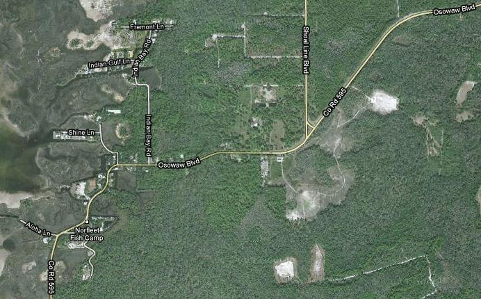
5 Segment 8-1: CR 595 (Osowaw Boulevard) From South of Fiddler Lane to West of Buccaneer Boulevard Segment Description: This segment of CR 595 (MP 0.7 to 2.8) is located in southwestern Hernando County and is a two-lane undivided rural east/west collector. Land uses adjacent to the road are vacant and limited residential west of Shoal Line Boulevard. The speed limit is 55 MPH just west of US 19, reducing incrementally to 20 MPH near the Pasco County Line. Lane widths are generally 12 feet in the eastern portions of the segment and less in the curve areas toward the west and south. Crash History and Background: The crash information as supplied by the District (CDMS data) indicated 14 crashes within this 1.9 mile section with two fatalities. The following tables show the crash distribution by day of week, time of day and yearly trend. The majority of crashes occurred on Saturday; between the hours of 12:00 AM 2:00 AM and 4:00 PM 5:00 PM; with 2008 having the most crashes. Hernando_HRRRP_Final Page 3 of 45 February 2010


6 The following distribution table shows the number of crashes, fatalities and injuries associated with the types of crashes that were recorded for this segment. Crashes are categorized by first harmful event which occurred during the crash. Also shown for each crash type is the number of such crashes which fall into each of the four FDOT Strategic Highway Safety Plan (SHSP) emphasis areas. Crashes involving lane departures occurred most frequently, as might be expected for local rural roads. Additionally, long form crash reports as supplied by the District were also reviewed and a summary table was created. Information such as location, number and type of vehicles and narrative on the crash sequence was some of the data that was tabulated from the crash forms and is shown below. An estimated mile post for the crash locations and an aerial map link of this point was submitted with the CDMS Selection Set file for this roadway segment. The approximate crash locations were mapped on an aerial of the CR 595 segment. This graphic shows the general location of the crashes and is color coded as reported in the crash form: no injury, injury or fatality. This map is included in the Appendix at the end of this document. Issue: Lane Departure Crashes on Horizontal Curves Location: Curves West of Buccaneer Boulevard Five of the 14 recorded crashes on this segment occurred on or near two reverse curves located between Shoal Line Road and Buccaneer Boulevard. All were recoded as lane departure crashes and in most instances the investigating officer estimated the vehicle speed to be in excess of the posted 55 MPH speed limit. Three of the crashes, resulting in two injuries and one fatality, were specifically noted as occurring on the curves. No curve warning signs currently exist on the curves. A cursory ball bank test, performed by the RSA team, indicated the curves may be comfortably driven at the posted 55 MPH speed limit; however, this test was not conclusive. Hernando_HRRRP_Final Page 4 of 45 February 2010


7 Consider the installation of curve warning signs (W1-2) for both approaches on the longer, sharper curve. The RSA team also suggests that a standard ball bank curve speed test be performed to determine if a speed advisory plaque is warranted. Pavement Edge Drop-offs A narrow shoulder pavement has been constructed on the inside of the two reverse curves; however, at the extremities of this shoulder pavement and also in the vicinity of the Shoal Line Boulevard intersection, there are crude, uneven asphalt patches which may present a hazard to vehicles drifting off the travel lanes. Consider the construction of a three to four foot paved shoulder on both sides of CR 595 from Buccaneer Boulevard through the intersection of Shoal Line Boulevard. As a short term measure, consider regrading and repaving or resodding those areas with poor shoulder pavement. Issue: Cluttered, Damaged and Misplaced Signage Location: CR 595 and Shoal Line Boulevard Intersection Background: Shoal Line Boulevard intersects CR 595 in a modified T configuration where southbound Shoal Line Boulevard to southbound CR 595 movements utilize a single, one-way lane which connects to CR 595 at a YIELD condition located about 150 feet south of the main intersection. (See left photo.) Traffic travelling eastbound on CR 595 wishing to go northbound on Shoal Line Boulevard must make a 90-degree left turn at the T-intersection. The predominant movements are between Shoal Line Boulevard and CR 595 to the east. Only one crash was recorded at the intersection and it involved a police chase. The double-arrow warning sign (W12-1) located in triangular grassed island facing southbound Shoal Line Boulevard traffic has been knocked down. Repair or replace damaged sign. Hernando_HRRRP_Final Page 5 of 45 February 2010


8 Description of Safety Issue (Westbound Departure from Intersection): On the north shoulder of westbound CR 595, just after the southbound Shoal Line Boulevard connection, there are four signs located in very close proximity. The first is a REDUCED SPEED AHEAD advising of the upcoming 35 MPH speed limit; the second is a route confirmation marker for CR 595; the third is a truck weight restriction sign for bridges located further to the west/south on CR 595; and the fourth is a bicycle route sign. These signs are all located very close to one another, within a curve, where a driver should be more focused on vehicle guidance tasks rather than navigational tasks. The curve itself has no advance warning signs for the southbound direction. Consider a comprehensive review of signing for the westbound CR 595 approach to and departure from the Shoal Line Boulevard intersection for the purpose of prioritizing and optimizing placement of warning, regulatory and guidance information to be conveyed to the driver. Consideration should be given to relocating the transition from 45 MPH to 35 MPH further to the west; installation of curve warning sign (W1-2) with a supplemental intersecting street name plaque (W16-8P) east of the intersection; installation of a larger truck weight restriction sign (R12-5) east of the Shoal Line Boulevard intersection; and relocation of bicycle route signing well beyond the curve. Description of Safety Issue (Eastbound Approach to Intersection): A single DO NOT ENTER sign is the only deterrent to a eastbound CR 595 motorist turning the wrong way up the one-way travel lane provided for southbound Shoal Line Boulevard traffic. County route signs (M1-6) with arrows (M6-1) for CR 597 (Shoal Line Boulevard) and CR 595 are located on a single assembly in advance of the intersection. The left arrow for CR 597 could be erroneously interpreted by an unfamiliar motorist as directing a turn the wrong way up the one-way southbound lane. These signs and the CR 597 junction sign to the south are faded and have poor visibility. Consider the installation of second DO NOT ENTER sign (R5-1) on the left shoulder of the one-way lane which would face eastbound CR 595 traffic. This would provide greater impact and redundancy. In conjunction with this, consider the installation of a WRONG WAY sign (R5-1a) further up the one-way lane nearer the gore area. To better indicate the proper point at which eastbound lefts should turn onto Shoal Line Boulevard, consider installing a new series of county route signs (M1-6) consisting of an advance CR 597 junction sign (M2-1) south of the curve; a two-panel CR 597 and CR 595 sign (M1-6) supplemented with an advance turn arrow (left arrow with vertical shaft) auxiliary sign (M5-1) for CR 597 a vertical arrow (M6-3) for CR 595 installed just before the one-way Hernando_HRRRP_Final Page 6 of 45 February 2010

 with 20 MPH advisory speed plaques in advance of the curves to properly advise the motorist of the alignment to be expected.")


9 entrance to direct left turns to a further point; and a similar two-panel combination route sign (M1-6) with a left arrow auxiliary sign (M6-1) for CR 597 and a vertical arrow (M6-3) for CR 595 at the T where left turns are made. Location: Curves Between Shine Lane and Aloha Lane Issue: Location of Chevron Signs There is a series of closely-spaced, reverse curves within a three-quarter mile section of CR 595 running southwest from Shine Lane to Aloha Lane. There are winding road warning signs (W1-5) with 20 MPH advisory speed plaques in advance of the curves to properly advise the motorist of the alignment to be expected. Chevron signs have also been installed along the roadway at most curve locations; however, the placement of the chevrons is not optimal and sometime does not effectively provide guidance through the entire curve. Also, foliage presently or will soon obscure some signs, chevrons and object markers. Consider reviewing this series of curves for the purpose of optimizing the location and conspicuity of signs, chevrons and object markers. Trim foliage to right-of-way limits. Add object markers for rigid roadside obstacles close to the travel lanes. Location: Bridge on Curve West of Shine Lane Issue: Pavement Depression at Bridge Approaches on Curve One report for a crash involving a motorcycle recorded the stated cause as a depression in the pavement at the bridge approach, which is on a horizontal curve. The RSA team reviewed the location and found the bridge to be a large box culvert, possibly without an approach slab. There is a depression in the asphalt at both ends of the concrete deck where subsidence has occurred. Although on a low speed curve, such a depression could indeed be a hazard to a motorcycle banked and travelling above the advisory speed of 20 MPH. Hernando_HRRRP_Final Page 7 of 45 February 2010


10 Consider replacement of asphalt approaches to the box culvert. Issue: Improper Height of Guardrail Guardrail along several sections of the roadway within the curves, especially on the approaches to the bridge, has rails which are located too low to the ground. Impact at high speed could result in a vehicle turning over the guardrail instead of being redirected back toward the roadway. Consider adjusting or replacing nonconforming guardrail, utilizing approved end anchorage treatments. Location: Vicinity of Indian Creek Bridge Issue: Unprotected Roadside Canals At several locations along CR 595 there are canals and tidal marsh areas located very close to the travel lanes. No guardrail exists in most places to redirect errant vehicles back onto the roadway. Several long sections of canal resulting from roadway fill excavation are located along a series of curves in the vicinity of Indian Creek. These canals are only feet from the edge of the travel lane. Hernando_HRRRP_Final Page 8 of 45 February 2010


11 Consider the installation of guardrail along canal sections. Where guardrail is impractical, consider the installation of delineator posts at the edge of the mowed shoulder to enhance guidance along these sections. Location: East of Indian Creek Issue: Stone Structure Adjacent to Travel Lane There is a stone structure approximately six feet off the right edge of the travel lane on the outside of a curve just east of the culvert at Indian Creek. The structure most likely monuments a property corner, but poses a hazard to passing traffic. There are no markings to identify the structure as a roadside hazard. Consider installation of an object marker (OM3-R) in front of the stone structure. Location: Curve North of Fiddler Lane Issue: Large Rocks Adjacent to Travel Lane Large rocks have been placed very close to the roadway, presumably by the adjacent property owner, to discourage vehicles for driving or parking on the grassed property. Although the roadway winds considerably in this area and the speed limit is only 20 MPH, the rocks pose a hazard and could damage a vehicle if struck. Consider investigating the right-of-way limits in this area and prevail upon the property owner to move the rocks to beyond the right-of-way line. If no right-of-way is available, consider a more uniform type of barrier such as slotted curbing. Hernando_HRRRP_Final Page 9 of 45 February 2010

 indicated 13 crashes within this 2.9 mile section.")
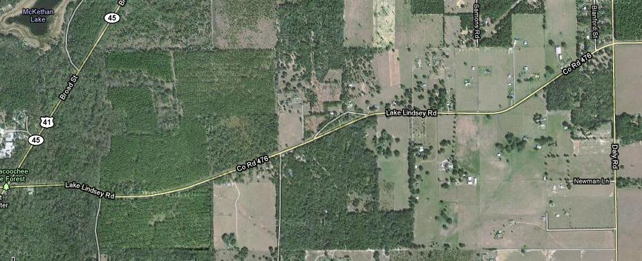
12 Segment 8-2 and 8-3: CR 476 (Lake Lindsey Road) From CR 481 (Snow Memorial Highway) to Withlacoochee Trail Segment Description: These two segments (8-2, 8-3) of Lake Lindsey Road are located in northeast Hernando County. Lake Lindsey Road is a two-lane undivided rural east/west collector. Land uses adjacent to the road are agricultural and residential. There are approximately four sets of curves in these segments. The speed limit is 55 MPH with lane widths generally 12 feet. Crash History and Background for Segment 8-2: The crash information for Segment 8-2 as supplied by the District (CDMS data) indicated 13 crashes within this 2.9 mile section. The following tables show the crash distribution by day of week, time of day and yearly trend. The majority of crashes occurred on Thursday through Sunday; between 7:00 AM 8:00 AM, 8:00 PM 9:00 PM and 11:00 PM to midnight; with 2006 having the most crashes. Hernando_HRRRP_Final Page 10 of 45 February 2010

13 The following distribution table shows the number of crashes, fatalities and injuries associated with the types of crashes that were recorded for this segment. Crashes are categorized by first harmful event which occurred during the crash. Also shown for each crash type is the number of such crashes which fall into each of the four FDOT Strategic Highway Safety Plan (SHSP) emphasis areas. Crashes involving lane departures occurred most frequently, as might be expected for local rural roads. Additionally, long form crash reports as supplied by the District were also reviewed and a summary table was created. Information such as location, number and type of vehicles and narrative on the crash sequence was some of the data that was tabulated from the crash forms and is shown below. The number of crashes from this data was slightly greater than the CDMS report. An estimated mile post for the crash locations and an aerial map link of this point was submitted with the CDMS Selection Set file for this roadway segment. The approximate crash locations were mapped on an aerial of the CR 476 segment. This graphic shows the general location of the crashes and is color coded as reported in the crash form: no injury, injury or fatality. This map is included in the Appendix at the end of this document. Crash History and Background for Segment 8-3: The crash information for Segment 8-3 as supplied by the District (CDMS data) indicated 10 crashes within this 2.4 mile section. The following tables show the crash distribution by day of week, time of day and yearly trend. The majority of crashes occurred on Friday; between 7:00 AM 8:00 AM and 11:00 PM to midnight; with 2006 having the most crashes. Hernando_HRRRP_Final Page 11 of 45 February 2010

14 The following distribution table shows the number of crashes, fatalities and injuries associated with the types of crashes that were recorded for this segment. Crashes are categorized by first harmful event which occurred during the crash. Also shown for each crash type is the number of such crashes which fall into each of the four FDOT Strategic Highway Safety Plan (SHSP) emphasis areas. Crashes involving lane departures occurred most frequently, as might be expected for local rural roads. Additionally, long form crash reports as supplied by the District were also reviewed and a summary table was created. Information such as location, number and type of vehicles and narrative on the crash sequence was some of the data that was tabulated from the crash forms and is shown below. An estimated mile post for the crash locations and an aerial map link of this point was submitted with the CDMS Hernando_HRRRP_Final Page 12 of 45 February 2010


 on both sides of the roadway. Considering the speed of the facility, the RSA team suggests 36 x 36 inch fluorescent yellow-green signs.")
15 Selection Set file for this roadway segment. The approximate crash locations were mapped on an aerial of the CR 476 segment. This graphic shows the general location of the crashes and is color coded as reported in the crash form: no injury, injury or fatality. This map is included in the Appendix at the end of this document. Issue: Trail Crossing Signage Location: Withlacoochee Trail Crossing The series of pedestrian crossing warning signs presently installed on Lake Lindsey Road at the Withlacoochee Trail do not conform to current MUTCD standards. Although there was little pedestrian or bicycle activity while the RSA team observed the trail crossing, County staff advise that trail traffic is much greater on weekends. The posted speed limit in this section is 55 MPH and there is a curve to the east of the trail crossing. Pedestrian and bicyclist safety could be enhanced with larger, more conspicuous signage. Consider the installation of new pedestrian/bicycle warning signs, consisting of advance warning signs (W11-15) with TRAIL CROSSING supplemental plaques (W11-15P) and crossing warning signs (W11-15) with supplemental arrow plaques (W16-7P) on both sides of the roadway. Considering the speed of the facility, the RSA team suggests 36 x 36 inch fluorescent yellow-green signs. Issue: Pedestrian/Bicycle Protection at Trail Crossing Pedestrian and bicycle traffic are regulated at the crossing by STOP signs facing the trail. The STOP signs are supplemented by two small warning signs affixed to a post adjacent to the trail which display STOP AHEAD and CAUTION HEAVY TRAFFIC. The RSA team speculated that the overall signing that exists at this crossing (and presumably at other roadway crossings along the trail) may be a combination of signing installed by the trail s maintaining agency and trail enthusiasts and may not be optimal in providing safety to trail users. Hernando_HRRRP_Final Page 13 of 45 February 2010


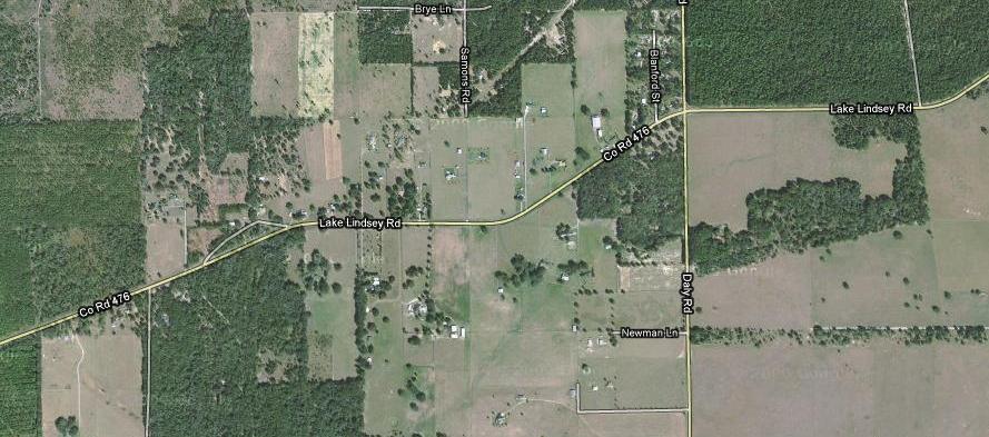
16 The RSA team suggests that the County coordinate with the Office of Greenways and Trails, Florida Department of Environmental Protection to encourage a systematic review of trail crossings of public highways in Citrus, Hernando and Pasco counties, through which the Withlacoochee Trail runs. In conjunction with this, the County is encouraged to evaluate the applicability of pedestrian/bicyclist-activated supplemental flashing beacons on the trail crossing warning signs. Revised warrants and guidance for such mid-block pedestrian crossings are contained in FDOT s Traffic Engineering Manual, Section 3.8 Issue: Passing Zone Through Trail Crossing Lake Lindsey Road is marked to allow passing, in the eastbound direction, coming out of the curve to the west of the trail crossing. This eastbound passing zone extends through the trail crossing area. Pedestrians and bicyclists may judge their ability to cross Lake Lindsey Road safely relative to the speed of approaching vehicles; a higher speed vehicle may pull out to pass a slower vehicle, surprising someone crossing the road. Vehicles engaged in passing maneuvers may exhibit speeds well in excess of the posted 55 MPH speed limit, increasing the likelihood that any crash will be very serious. Consider restriping Lake Lindsey Road to create a no-passing zone through the Withlacoochee Trail crossing area. Issue: STOP Ahead Warning on Daly Road Location: Daly Road Intersection On the northbound Daly Road approach to the Lake Lindsey Road intersection, there is no STOP ahead warning sign. There is one on the southbound approach (photo on right). Consider installation of STOP ahead warning sign (W3-1) on the northbound approach. Hernando_HRRRP_Final Page 14 of 45 February 2010


 for right turning vehicles.")

17 Issue: Markings for Eastbound to Northbound Right-Turn Lane There is a right-turn lane on Lake Lindsey Road at Daly Road for the eastbound to northbound right turn. The turn lane curves to the right to conform to the roadway alignment at this point. There is a short taper at the beginning of the turn lane, marked by a short segment of skip line indicating the lane changing area. Drivers changing lanes in the skip line area will need to steer to the right, straighten their vehicle and then steer to the right again as they enter the curve. A single, gradual movement into the right turn lane can be made if the driver changes lanes across the solid lane line slightly beyond the marked skip area. Consider eradicating portions of the solid lane line separating the through and right-turn lanes to create a longer skip line segment (approximately 135 feet) for right turning vehicles. Issue: Advance Curve and Intersection Warning Daly Road intersects Lake Lindsey Road on a curve. There are curve warning signs on Lake Lindsey Road, but there are no intersection warning signs. Common white-on-green street name signs are the only identification of Daly Road. Unfamiliar drivers coming from either direction seeking Daly Road would have to observe the street name sign while guiding the vehicle through a curve. Also, there is a bike route sign (W11-1) facing westbound traffic just before the start of the curve. The information conveyed by this sign competes with curve and intersection information. Consider replacing the existing curve warning signs with new curve warning signs depicting the intersecting crossroad within the curve (W1-10a). Subsequent to the curve warning signs, install intersection warning signs (W2-1) with supplemental street name plaques (W16-8P) identifying Daly Road as the cross road. Also, consider relocating the bike route sign to another location. Hernando_HRRRP_Final Page 15 of 45 February 2010
 with 30 MPH advisory speed plaques (W13-1P) currently exist in advance of the curves.")

 Issue: Roadside Cross-drain and Side-drain Headwall Hazards The segment of Lake Lindsey Road between CR 481 and US 41 is posted at 50")

18 Location: Curves West of US 41 Issue: Curve Warning Signage There are two reverse curves on Lake Lindsey Road approximately one third mile west of US 41. Turn warning signs (W1-1) with 30 MPH advisory speed plaques (W13-1P) currently exist in advance of the curves. A left turn arrow (W1-6) and three object markers (OM1-1), facing eastbound traffic in advance of the first curve encountered, are the only warning devices located within the curves to provide additional guidance to the driver. Consider removal of the arrow and object markers and installation of chevron signs (W1-8) on the outside of both curves to enhance curve guidance and visibility at night. Location: East of CR 481 (Snow Memorial Highway) Issue: Roadside Cross-drain and Side-drain Headwall Hazards The segment of Lake Lindsey Road between CR 481 and US 41 is posted at 50 MPH. In a tangent section one half mile east of CR 481, the roadway is 18 feet in width. The roadway alignment appears to have been curved slightly to avoid a large diameter oak tree which is only about four feet off the edge of pavement. An object marker has been installed in front of the tree. At this same location, there are several side-drains and cross-drains which have vertical headwalls which pose a roadside hazard. It is believed these headwalls are within the right-of-way. Consider removal of the oak tree and construction of mitered end sections on the drainage structures. Hernando_HRRRP_Final Page 16 of 45 February 2010
 is currently under construction to widen from two to four lanes from SR 50 (Cortez Boulevard) to north of Ken Austin Parkway.")
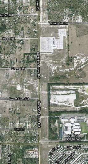
19 Segment 8-4: CR 493 (Sunshine Grove Road) From North of Star Road to North of Scrub Oak Lane Sunshine Grove Road MP 1.8 to 3.2) is currently under construction to widen from two to four lanes from SR 50 (Cortez Boulevard) to north of Ken Austin Parkway. Half of the recorded crashes (6 of 12) occurred within the section to be widened and all of these were related to the Ken Austin Parkway intersection which is the main access to Central High School. This intersection and the access roadway alignment will be totally reconstructed during the widening project, presumably correcting geometric and operational deficiencies which have led to the existing crash history. The RSA team reviewed the remaining crash history and field reviewed the section of Sunshine Grove Road north of the construction limits and observed no deficiencies or opportunities to improve safety. Crash History and Background: The crash information as supplied by the District (CDMS data) indicated 12 crashes within this 1.4 mile section. The following tables show the crash distribution by day of week, time of day and yearly trend. The majority of crashes occurred on Wednesday; between 6:00 PM 7:00 PM; with 2007 having the most crashes. Hernando_HRRRP_Final Page 17 of 45 February 2010

20 The following distribution table shows the number of crashes, fatalities and injuries associated with the types of crashes that were recorded for this segment. Crashes are categorized by first harmful event which occurred during the crash. Also shown for each crash type is the number of such crashes which fall into each of the four FDOT Strategic Highway Safety Plan (SHSP) emphasis areas. Rear end and left turn were the most prevalent crashes, reflecting the signalized intersection within the segment. Additionally, long form crash reports as supplied by the District were also reviewed and a summary table was created. Information such as location, number and type of vehicles and narrative on the crash sequence was some of the data that was tabulated from the crash forms and is shown below. An estimated mile post for the crash locations and an aerial map link of this point was submitted with the CDMS Selection Set file for this roadway segment. The approximate crash locations were mapped on an aerial of the CR 493 segment. This graphic shows the general location of the crashes and is color coded as reported in the crash form: no injury, injury or fatality. This map is included in the Appendix at the end of this document. Hernando_HRRRP_Final Page 18 of 45 February 2010
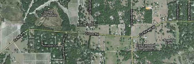
21 Segment 8-5: CR 480 (Croom Road) From East of US 41 (Broad Street) to East of Dempsey Road Segment Description: This segment of CR 480 (Croom Road) is located in central Hernando County northeast of Brooksville. It is a twolane undivided rural east/west collector. Land uses adjacent to the road are agricultural and residential. The speed limit ranges from 35 MPH to 45 MPH with lane widths generally 12 feet. Crash History and Background: The crash information as supplied by the District (CDMS data) indicated 8 crashes within this 1.8 mile section. The following tables show the crash distribution by day of week, time of day and yearly trend. The majority of crashes occurred on Sunday and Friday; between 5:00 PM 6:00 PM; with 2008 having the most crashes. Hernando_HRRRP_Final Page 19 of 45 February 2010

22 The following distribution table shows the number of crashes, fatalities and injuries associated with the types of crashes that were recorded for this segment. Crashes are categorized by first harmful event which occurred during the crash. Also shown for each crash type is the number of such crashes which fall into each of the four FDOT Strategic Highway Safety Plan (SHSP) emphasis areas. Crashes involving lane departures occurred most frequently, as might be expected for local rural roads. Additionally, long form crash reports as supplied by the District were also reviewed and a summary table was created. Information such as location, number and type of vehicles and narrative on the crash sequence was some of the data that was tabulated from the crash forms and is shown below. An estimated mile post for the crash locations and an aerial map link of this point was submitted with the CDMS Selection Set file for this roadway segment. The approximate crash locations were mapped on an aerial of the CR 480 segment. This graphic shows the general location of the crashes and is color coded as reported in the crash form: no injury, injury or fatality. This map is included in the Appendix at the end of this document. Issue: Variable Posted Speed Limit Location: Corridor Wide The posted speed limit on Croom Road is 40 MPH for about 2.0 miles from US 41 to east of Magilligan Drive where it increases to 45 MPH for about 1.1 miles, and then reduces to 35 MPH from west of Waverly Road eastward to the end of the paved roadway. The character of the roadway and the adjacent land use is little different in the 45 MPH section than it is in the 40 MPH section to the west, although there are fewer intersecting side roads. There is, however, a horizontal curve within the 45 MPH section which has an advisory speed of 35 MPH. Four of the eight recorded crashes, all involving lane departures, occurred within or near this curve. If motorists complied strictly to the posted speed limit and advisory speed signs, their speed would vary from 40 MPH to 45 MPH to 35 MPH to 45 MPH and then down to 35 MPH, all within 1.25 miles. The RSA team suggests that the 40 MPH posted speed limit be extended from US 41 to the beginning of the existing 35 MPH zone, eliminating the 45 MPH section altogether. Hernando_HRRRP_Final Page 20 of 45 February 2010
.")

 and 35 MPH advisory speed plaques (W13-1P) on the curve between")
23 Issue: Missing and Non-reflective Raised Pavement Markers The night review of the Croom Road segment revealed that a significant number of RPM s were either missing or non-reflective, resulting in poor nighttime guidance for the driver, especially during wet conditions. Consider installing new RPM s throughout the entire paved section of Croom Road (approximately 4.5 miles). Issue: STOP Ahead Warning Sign Location: East of US 41 (Broad Street) There is no STOP ahead warning sign on the westbound Croom Road approach to the US 41 intersection. Croom Road curves to the right at this location and three large trees on the right shoulder limit visibility of the STOP sign ahead at the intersection. Further, the three trees, which are about eight feet from the edge of pavement, pose a hazard to traffic. Consider removing the three trees and installing a STOP ahead warning sign (W3-1). Issue: Curve Warning Signage Location: Curve Between Magilligan Drive and Nottingham Forest Drive There are curve warning signs (W1-2) and 35 MPH advisory speed plaques (W13-1P) on the curve between Magilligan Drive and Nottingham Forest Drive. There is also a slight vertical curve which limits the westbound driver s view of the pavement as he approaches the curve. Guidance through the curve is not optimal. Consider installation of chevron signs (W1-8) on the outside of the curve for both directions of travel. Hernando_HRRRP_Final Page 21 of 45 February 2010

24 Location: Curves East of Weatherly Road Issue: Edge of Pavement Drop-off There are edge of pavement drop-offs within the curves just east of Weatherly Road. The curves are sharp and have an advisory speed of 15 MPH. Consider the addition of a paved shoulder on the inside of the curves. In the interim, regrade and resod shoulders to eliminate edge of pavement drop-offs. Hernando_HRRRP_Final Page 22 of 45 February 2010
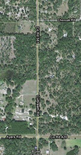
25 Segment 8-6: CR 581 (Culbreath Road) From CR 576 (Ayers Road/Hayman Road) to North of Chenoak Road Segment Description: This segment of CR 581 (Culbreath Road) is located in south central Hernando County and is a two-lane undivided rural north/south collector. Land uses adjacent to the road are agricultural and residential. This segment is straight with no curves throughout its length. The speed limit is 45 MPH with lane widths are generally 12 feet. Crash History and Background: The crash information as supplied by the District (CDMS data) indicated 8 crashes within this 1.0 mile section. The following tables show the crash distribution by day of week, time of day and yearly trend. The majority of crashes occurred on Sunday and Tuesday; between 9:00 AM and 10:00 AM; with 2005 and 2008 having the most crashes. Hernando_HRRRP_Final Page 23 of 45 February 2010


26 The following distribution table shows the number of crashes, fatalities and injuries associated with the types of crashes that were recorded for this segment. Crashes are categorized by first harmful event which occurred during the crash. Also shown for each crash type is the number of such crashes which fall into each of the four FDOT Strategic Highway Safety Plan emphasis areas. Crashes involving lane departures occurred most frequently, as might be expected for local rural roads. Additionally, long form crash reports as supplied by the District were also reviewed and a summary table was created. Information such as location, number and type of vehicles and narrative on the crash sequence was some of the data that was tabulated from the crash forms and is shown below. An estimated mile post for the crash locations and an aerial map link of this point was submitted with the CDMS Selection Set file for this roadway segment. The approximate crash locations were mapped on an aerial of the CR 581 segment. This graphic shows the general location of the crashes and is color coded as reported in the crash form: no injury, injury or fatality. This map is included in the Appendix at the end of this document. Issue: Rumble Strips Location: Ayers Road / Hayman Road Intersection Six of the eight crashes recorded for this segment occurred at the Ayers Road/Hayman Road intersection with Culbreath Road. The Ayers Road and Hayman Road approaches are controlled by a STOP sign and a flashing red beacon; Culbreath Road is controlled by a flashing yellow beacon. There are also rumble strips on the Ayers Road and Hayman Road approaches to alert motorists of the STOP condition. In response to crashes at the intersection, even with the flashing beacons, the County has installed supplemental plaques below the STOP signs on Ayers Road and Hayman Road which warn the driver that cross traffic does not stop. County staff believes that the supplemental warning has been effective in reducing the right angle and left turn crashes. The RSA team observed one vehicle approaching the intersection westbound on Hayman Road that drove on the eastbound lane of the roadway to avoid the rumble strips. A closer look at the rumble strips revealed that they were relatively tall, possibly causing excessive vibration for familiar motorists. Hernando_HRRRP_Final Page 24 of 45 February 2010


27 Consider replacing the existing rumble strips with lower profile rumble strips or rumble stripes instead. Issue: Vegetation Limiting Sight Distance Sight lines are limited somewhat for stopped traffic on Ayers Road and Hayman Road because of foliage from trees within or adjacent to the right-of-way. Consider trimming foliage overhanging roadway and encroaching into the right-of-way. Issue: Sign Spacing on Northbound Culbreath Road Approach There is a sign on the northbound approach to the intersection advising motorists to turn onto Ayers Road to reach the Fort Taylor Cemetery. The sign is relatively close to and in front of the intersection warning sign and detracts from the importance of that sign. Consider relocating the cemetery sign closer to the intersection beyond the route marker sign. Hernando_HRRRP_Final Page 25 of 45 February 2010


28 Issue: Culvert Headwalls Culvert headwalls are located very close to the corner radius in each of the four quadrants of the intersection. Only one of these headwalls is designed with a mitered end section; the other three have vertical headwalls which pose a hazard to errant passing vehicles or those which swerve off the roadway to avoid turning vehicles. Consider constructing mitered end sections on the three culverts with vertical headwalls. Hernando_HRRRP_Final Page 26 of 45 February 2010
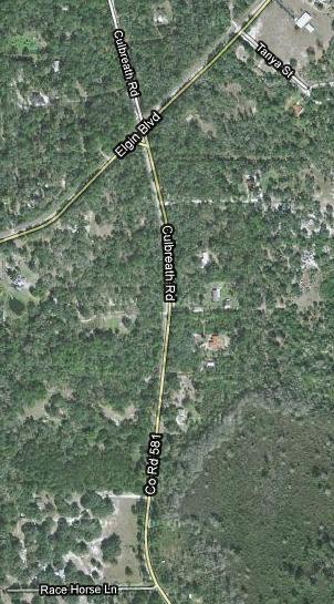
29 Segment 8-7: CR 581 (Culbreath Rd.) From South of Moore Road to North of Powell Road Segment Description: This segment of CR 581 (Culbreath Road) is located in south central Hernando County and is a two-lane undivided rural north/central collector. Land uses adjacent to the road are agricultural and residential. The speed limit is 45 MPH with lane widths generally 12 feet. Three sets of curves are in this segment. Crash History and Background: The crash information as supplied by the District (CDMS data) indicated 8 crashes within this 1.4 mile section. The following tables show the crash distribution by day of week, time of day and yearly trend. The majority of crashes occurred on Sunday; between 7:00 AM and 7:00 PM; with 2005 having the most crashes. The following distribution table shows the number of crashes, fatalities and injuries associated with the types of Hernando_HRRRP_Final Page 27 of 45 February 2010


30 crashes that were recorded for this segment. Crashes are categorized by first harmful event which occurred during the crash. Also shown for each crash type is the number of such crashes which fall into each of the four FDOT Strategic Highway Safety Plan emphasis areas. Crashes involving lane departures occurred most frequently, as might be expected for local rural roads. Additionally, long form crash reports as supplied by the District were also reviewed and a summary table was created. Information such as location, number and type of vehicles and narrative on the crash sequence was some of the data that was tabulated from the crash forms and is shown below. The number of crashes from this data was substantially greater than the CDMS report. An estimated mile post for the crash locations and an aerial map link of this point was submitted with the CDMS Selection Set file for this roadway segment. The approximate crash locations were mapped on an aerial of the CR 581 segment. This graphic shows the general location of the crashes and is color coded as reported in the crash form: no injury, injury or fatality. This map is included in the Appendix at the end of this document. Issue: Roadway Alignment Location: Curves South of Moore Road There is a reverse curve south of Moore Road which appears to have been built to skirt around a sink hole which lies along the alignment of Culbreath Road. There is a winding road warning sign (W1-5) on the northbound approach to this curve and on the southbound approach to a separate curve north of Moore Road; however, there are no advisory speed plaques on either sign. The posted speed limit in this area is 45 MPH. Consider conducting ball bank indicator tests to determine if advisory speed plaques are warranted for the curves. Hernando_HRRRP_Final Page 28 of 45 February 2010

31 Issue: Foliage Partially Obscuring STOP Sign Location: Northbound Approach to Powell Road Intersection Foliage from a large oak tree is partially obscuring the view of the STOP sign at the Powell Road intersection. Consider trimming oak tree branches within the right-of-way to a level above the STOP sign. Hernando_HRRRP_Final Page 29 of 45 February 2010
32 Segment 8-8: CR 572 (Powell Road) From West of Crum Road to East of Saturn Road Segment Description: This segment of CR 572 (Powell Road) is located in central Hernando County south of Brooksville and is a twolane undivided rural east/west collector. Land uses adjacent to the road are agricultural and residential. The speed limit is 50 MPH with lane widths generally 12 feet. There are two curves on the segment with a railroad crossing at a diagonal at one of them. Crash History and Background: The crash information as supplied by the District (CDMS data) indicated 15 crashes within this 1.3 mile section with one fatality. The following tables show the crash distribution by day of week, time of day and yearly trend. The majority of crashes occurred on Sunday and Monday; between 1:00 AM 2:00 AM and 7:00 PM 8:00 PM; with 2006 and 2008 having the most crashes. Hernando_HRRRP_Final Page 30 of 45 February 2010


33 The following distribution table shows the number of crashes, fatalities and injuries associated with the types of crashes that were recorded for this segment. Crashes are categorized by first harmful event which occurred during the crash. Also shown for each crash type is the number of such crashes which fall into each of the four FDOT Strategic Highway Safety Plan (SHSP) emphasis areas. Crashes involving lane departures occurred most frequently, as might be expected for local rural roads. Additionally, long form crash reports as supplied by the District were also reviewed and a summary table was created. Information such as location, number and type of vehicles and narrative on the crash sequence was some of the data that was tabulated from the crash forms and is shown below. An estimated mile post for the crash locations and an aerial map link of this point was submitted with the CDMS Selection Set file for this roadway segment. The approximate crash locations were mapped on an aerial of the CR 572 segment. This graphic shows the general location of the crashes and is color coded as reported in the crash form: no injury, injury or fatality. This map is included in the Appendix at the end of this document. Issue: Lane Departure Crashes on Horizontal Curve Location: Curve East of Racers Way Eight lane departure crashes involving one fatality (motorcycle) and seven injuries occurred within or on the approaches to the horizontal curve located approximately one quarter mile east of Racers Way. Crash reports did not identify any defects in the road condition and none were noted by the RSA team. Five of the eight occurred at night. The driver was faulted and charged in two of the eight crashes. The posted speed limit on Powell Road is 50 MPH. Travel lanes are 11 feet in width and there is a paved shoulder about 3 feet in width on the inside of the curve. Curve warning signs (W1-2) are in place with 40 MPH speed advisory plaques (W13-1P) on both approaches. These signs are 30 X 30 inches and are in good condition. Hernando_HRRRP_Final Page 31 of 45 February 2010

 on warning and chevron sign posts.")


34 Consider replacing the existing 30 X 30 inch curve warning signs (W1-2) with 36 X 36 inch signs and 24 X 24 inch advisory speed panels (W13-1P). Although the 40 MPH advisory speed appeared reasonable to the RSA team, it is suggested that it be validated and adjusted as necessary. Also, consider installation of chevron signs (W1-8) on the outside of the curve. To increase impact of these signs at night, consider installation of vertical reflective strips ( Brite Sticks ) on warning and chevron sign posts. As a longer-term improvement, consider the construction of 3-4 foot paved shoulders on both sides of the roadway through the curve. Location: Reverse Curves at CSX Railroad Crossing and Saturn Road Issue: Departure Crashes on Horizontal Curves Six of the 15 recorded crashes, resulting in four injuries, occurred on or in the immediate vicinity of the CSX Railroad grade crossing located between two reverse curves. All were lane departure crashes and involved excessive speed. On the outside of the sharper of the two curves, close to the railroad crossing, there is an intersecting County road named Saturn Road. The crash history does not involve vehicles turning onto or from Saturn Road. Both approaches to the curves have 30 X 30 inch turn warning signs (W1-1) with 18 X 18 inch 25 MPH advisory speed plaques (W13-1P) and railroad crossing warning signs (W10-1) and pavement markings. A number of chevron signs (W1-8) have been installed on the outside of the sharper curve. Consider replacing the existing 30 X 30 inch turn warning signs (W1-1) with 36 X 36 inch prismatic, fluorescent yellow signs and 24 X 24 inch advisory speed panels (W13-1P). Also, consider installation of additional chevron signs (W1-8) on the outside of both curves to provide a higher level of warning and guidance. To increase impact of these signs at night, consider installation of vertical reflective strips ( Brite Sticks ) on warning and chevron sign posts. Hernando_HRRRP_Final Page 32 of 45 February 2010


35 Issue: Loose Gravel and Elevated Grassed Shoulder Location: Saturn Road The apron at the Saturn Road intersection is largely gravel and the shoulder immediately to the east is rutted and elevated above the Powell Road surface. Dirt and gravel from this intersection are a hazard to vehicles, especially motorcycles, making this sharp turn. Consider paving the intersection apron and regrading the shoulders. Hernando_HRRRP_Final Page 33 of 45 February 2010

 indicated 15 crashes within this 2.7 mile section with one fatality.")
36 Segment 8-9: CR 572 (Powell Road) From West of Rackley Road to East of CR 581 (Emerson Road) Segment Description: This segment of CR 579 (Powell Road) is located in central Hernando County south of Brooksville and is a twolane undivided rural east/west collector. Land uses adjacent to the road are agricultural and residential. The speed limit is 50 MPH with lane widths generally 12 feet. Numerous curves exist in this segment with reduced advisory speeds posted for them. Crash History and Background: The crash information as supplied by the District (CDMS data) indicated 15 crashes within this 2.7 mile section with one fatality. The following tables show the crash distribution by day of week, time of day and yearly trend. The majority of crashes occurred on weekdays; between 7:00 AM 8:00 AM; with 2006 and 2008 having the most crashes. Hernando_HRRRP_Final Page 34 of 45 February 2010

37 The following distribution table shows the number of crashes, fatalities and injuries associated with the types of crashes that were recorded for this segment. Crashes are categorized by first harmful event which occurred during the crash. Also shown for each crash type is the number of such crashes which fall into each of the four FDOT Strategic Highway Safety Plan (SHSP) emphasis areas. Crashes involving lane departures occurred most frequently, as might be expected for local rural roads. Additionally, long form crash reports as supplied by the District were also reviewed and a summary table was created. Information such as location, number and type of vehicles and narrative on the crash sequence was some of the data that was tabulated from the crash forms and is shown below. An estimated mile post for the crash locations and an aerial map link of this point was submitted with the CDMS Selection Set file for this roadway segment. The approximate crash locations were mapped on an aerial of the CR 572 segment. This graphic shows the general location of the crashes and is color coded as reported in the crash form: no injury, injury or fatality. This map is included in the Appendix at the end of this document. Issue: Curve Warning Signage Location: Horizontal Curves at Rackley Road and Endsley Road There are a series of successive horizontal curves between Saturn Road and CR 581 (Culbreath Road). Nine of the 15 crashes that were recorded for this section of Powell Road occurred within or near these curves; all were lane departure crashes. Within two of these curves are intersecting side roads to the south at Rackley Road and Endsley Road. Curve warning signs exist (W1-2) on the approaches to all of the curves; however, there are no indications of the intersecting roads. The curve warning sign for Endsley Road and the curve to the east have 35 MPH advisory speed plaques (W13-1P). Approaching drivers have difficulty seeing the intersecting side roads in advance because of horizontal and vertical curvature. Hernando_HRRRP_Final Page 35 of 45 February 2010
 and 24 X")
 are")


38 Consider upgrading the series of warning signs through these curves replacing existing 30 X 30 inch warning signs and 18 X 18 inch advisory speed plaques with 36 X 36 inch signs (W1-2 or W1-10) and 24 X 24 inch plaques (W13-1P). For the curves at Rackley Road and Endsley Road, signs showing the intersecting side road (W1-10) are recommended. Location: Endsley Road Intersection Issue: Pavement Depression on Ensley Road Intersection Radius There is a depression in the pavement on the intersection radius which could pose a hazard to eastbound Powell Road to southbound Endsley Road turning vehicles. Also, there is lateral drainage pipe under Endsley Road, the end of which is very close to the edge of pavement on the radius and severely damaged. Vehicles off-tracking at this point could be snagged by the metal pipe. Consider repaving the intersection radius to eliminate the pavement depression and repairing the damaged drainage pipe and providing a mitered end section. Hernando_HRRRP_Final Page 36 of 45 February 2010

.")


39 Issue: Street Termination Signage Endsley Road terminates at its T-intersection with Powell Road there is no street termination signage. Consider installation of standard street termination signage consisting of a double arrow sign (W1-7) and three object markers (OM1-1). Issue: Traffic Island Pavement Markings Location: CR 581 (Culbreath Road) Intersection The pavement markings which surround the traffic island in the southwest corner of the intersection do not have chevron striping to help define the boundaries of the island and guide the motorist. Consider restriping the island, providing appropriate chevron pavement markings to guide traffic movements. Issue: Intersecting Street Name Signing Intersection warning signs on the eastbound and westbound approaches to Culbreath Road are inconsistent. The westbound intersection warning sign (W2-1) has a street name plaque whereas the eastbound sign does not. Instead, there is a gold-on-blue street name plaque for Culbreath Road on the route sign assembly. Hernando_HRRRP_Final Page 37 of 45 February 2010


40 Consider adding a street name plaque (W16-8P) on the eastbound intersection warning sign and removing the one on the route sign assembly. Issue: Sand and Gravel from North Leg of Culbreath Road Culbreath Road is a graded road north of Powell Road and slopes downward away from the intersection. Although there is a short paved turnout on the north leg of Culbreath Road, sand and gravel is tracked onto the main intersection surface where it poses a hazard to southbound Culbreath Road traffic attempting to accelerate up the grade from a stopped condition. Loss of traction and exposure to passing Powell Road traffic could ensue. Consider extending the paved surface on Culbreath Road to the north for feet to eliminate the potential for loose material near and within the intersection. Hernando_HRRRP_Final Page 38 of 45 February 2010


41 Issue: Pavement Edge Drop-off There is an approximate 6-inch pavement edge drop-off in the northeast corner of the intersection. A small asphalt patch has been applied but it is insufficient to correct the problem. The drop-off poses a control hazard to eastbound motorists who might leave the pavement while swerving to avoid slowing or stopped vehicles turning left onto southbound Culbreath Road. Consider constructing a 3-4 foot shoulder in this area to accommodate the off-tracking that is apparent. Issue: Y Intersection Geometry Location: Emerson Road Intersection Emerson Road intersects Powell Road in a Y configuration. The southbound Emerson Road to westbound Powell Road movement is controlled by a YIELD condition and the southbound to westbound movement is controlled by a STOP condition. Drivers making the southbound to westbound movement under the YIELD condition must look far behind their left shoulder to judge the approaching traffic on Powell Rd. Most likely they are moving forward at a reduced speed anticipating a gap in traffic. If the gap is not there or a stopped vehicle on the other branch of the Y is blocking the view, conflicts and crashes may occur (See photo on right). There is no history of such crashes at present; however, higher traffic volumes in the future could increase the potential for crashes. Consider changing the YIELD control to STOP (R1-1) control and adding a stop line. If this is not practical, add yield lines at the YIELD (R1-2) sign. In the long term, consider reconstructing the intersection to make it a more conventional T-intersection, where the southbound to westbound movement would be controlled by a STOP condition. Hernando_HRRRP_Final Page 39 of 45 February 2010


42 Issue: Worn Pavement Markings Good pavement markings at this intersection are essential because each two-lane branch of the Y carries traffic flowing in opposite directions and traffic entering from Powell Road is apt to do so at a relatively high rate of speed as the geometry allows free-flowing turns. Drivers need the solid double yellow markings to know there is two-way traffic. The existing yellow markings are indiscernible and raised pavement markers are gone. Recommend restriping the intersection and replacing missing RPM s. Issue: Intersection and Route Signage The route marker sign on westbound Powell Road in advance of Emerson Road intersection has a supplemental plaque bearing the street name. The subsequent intersection warning sign, which should bear the intersecting street name, does not. Further, the warning sign (W2-2) depicts a 90-degree intersection when it is truly on about a 60-degree angle. Proper depiction of the intersection is especially important for westbound to northbound traffic which should turn at the first branch of the Y. Consider removal of the Emerson Road street name plaque from the eastbound route marker assembly and replacement of the existing intersection warning signs (W2-2) eastbound and westbound with the accurate intersection graphic (W2-3) and supplemental street name plaques for Emerson Road (W16-8P). Hernando_HRRRP_Final Page 40 of 45 February 2010
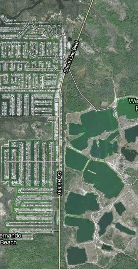
43 Segment 8-10: CR 597 (Shoal Line Boulevard) From South of Jew Fish Drive to North of Petit Lane Segment Description: This segment of CR 597 (Shoal Line Boulevard) is located in south west Hernando County near the Gulf coast and is a two-lane undivided rural north/south collector. Land uses adjacent to the road are residential and commercial within the Hernando Beach area. The speed limit is 50 MPH north of CR 595, 55 MPH north of Hernando Beach and 40 MPH within the Hernando Beach developed area with lane widths generally 12 feet. Crash History and Background: The crash information as supplied by the District (CDMS data) indicated 18 crashes within this 2.8 mile section. The following tables show the crash distribution by day of week, time of day and yearly trend. The majority of crashes occurred between Thursday and Sunday; between 2:00 PM and 3:00 PM; with 2006 having the most crashes. Hernando_HRRRP_Final Page 41 of 45 February 2010


44 The following distribution table shows the number of crashes, fatalities and injuries associated with the types of crashes that were recorded for this segment. Crashes are categorized by first harmful event which occurred during the crash. Also shown for each crash type is the number of such crashes which fall into each of the four FDOT Strategic Highway Safety Plan (SHSP) emphasis areas. Crashes involving lane departures occurred most frequently, as might be expected for local rural roads. Additionally, long form crash reports as supplied by the District were also reviewed and a summary table was created. Information such as location, number and type of vehicles and narrative on the crash sequence was some of the data that was tabulated from the crash forms and is shown below. An estimated mile post for the crash locations and an aerial map link of this point was submitted with the CDMS Selection Set file for this roadway segment. The approximate crash locations were mapped on an aerial of the CR 597 segment. This graphic shows the general location of the crashes and is color coded as reported in the crash form: no injury, injury or fatality. This map is included in the Appendix at the end of this document. Location: North of Hermosa Boulevard to North of Campanero Entra Issue: Passing Zone in Highly Developed Area Passing zones are limited along this segment of Shoal Line Boulevard, occurring in the undeveloped stretches with tangential alignment. No passing zones are established for major intersecting streets and on the horizontal curve within the section. However, there is a passing zone for the southbound direction of travel from north of Hermosa Boulevard to the beginning of the horizontal curve north of Campanero Entra. Campanero Entra is a the only access to a residential area of over 200 homes and County staff stated that ingressing and egressing traffic is significant. Further, there are numerous businesses along the roadway which also generate traffic. There was one recorded crash with injuries which involved a passing vehicle impacting a turning vehicle in this section. Consider restriping roadway to impose a no passing zone in this section. Hernando_HRRRP_Final Page 42 of 45 February 2010


45 Location: Campanero Entra Intersection Issue: Worn Pavement Markings Pedestrian crosswalk and stop line pavement markings on Campanero Entra are extremely worn, giving no indication where approaching vehicles should stop in advance of the crosswalk. Consider restriping the roadway to define stop line and crosswalk. Issue: Acute Intersection Angles Location: Intersections of Calienta Street and Petit Lane Calienta Street and Petit Lane intersect Shoal Line Boulevard at acute angles several hundred feet apart. Petit Lane then intersects with Calienta Street to form a large triangle. Both are two-way streets. Calienta Street continues to the north and serves one of the most popular public boat ramps in Hernando County. County staff advised that vehicles towing boat trailers abound on weekends and that the volume of turning movements to and from Petit Lane and Calienta Street sometimes creates a sort of gridlock at the three intersections. Movements to and from the north on Shoal Line Boulevard are particularly difficult for vehicles with trailers because of the acute intersection angles. Through traffic on Shoal Line Boulevard must often stop to give turning vehicles a chance to enter the traffic stream. Such constrained operations result in many vehicle conflicts and a crash history will most likely develop. Consider evaluating various options that would reduce the acute turning angles and better discipline traffic, especially at the Calienta Street intersection with Shoal Line Boulevard. Such options might include improved turning radius at Petit Lane, striping lanes and traffic islands at the Calienta Street intersection, and even establishing a one-way pair configuration with Calienta Street southbound and Petit Lane northbound. Hernando_HRRRP_Final Page 43 of 45 February 2010


46 Issue: Intersection Warning Signs There are no intersection warning signs on Shoal Line Boulevard in advance of either Calienta Street or Petit Lane. Warning signs with accurate representation of the acute intersection angle and street name signs would be very useful to unfamiliar drivers. Consider installation of intersection warning signs (W2-3) with accurate angle intersection graphics, supplemented with street name plaques (W16-8P). In this instance, one sign northbound for Calienta Street and one sign southbound for Petit Lane may be sufficient. Issue: Canal Hazard Location: Petit Lane Intersection There is a canal on either side of Petit Lane at its intersection with Shoal Line Boulevard. It is very close to the travel way and poses a hazard to southbound Shoal Line Boulevard vehicles turning onto Petit Lane, especially those towing trailers. Turning vehicles no doubt encroach onto the southbound travel lane of Petit Lane while carefully making the turn, risking collision with approaching vehicles on Petit Lane and posing an impediment to southbound through traffic on Shoal Line Boulevard. Consider extending the drainage pipes under Petit Lane and increasing the turning radius to accommodate vehicles towing boat trailers. A longer term suggestion would be to realign the Petit Lane connection to Shoal Line Boulevard to create more of a T intersection. Hernando_HRRRP_Final Page 44 of 45 February 2010

47 Issue: Turns Off-tracking on Shoal Line Boulevard Shoulder To avoid the canal drop-off and stopped vehicles on Shoal Line Boulevard, left turns from Petit Lane onto northbound Shoal Line Boulevard make wide turns and often track off the pavement onto the east shoulder of Shoal Line Boulevard. Some pavement has been placed at the location to prevent erosion, but there is a drop-off at the edge of the rudimentary shoulder pavement. The drop-off poses a hazard to vehicles operating during periods of free-flow traffic. Consider constructing a longer shoulder 3-4 feet in width to accommodate the turning movement tracking and through vehicles moving to the right to bypass slower turning vehicles. Hernando_HRRRP_Final Page 45 of 45 February 2010
48
49
50
51
52
53
54

55

56
57
High Risk Rural Road Program Road Safety Audit Report
 High Risk Rural Road Program Road Safety Audit Report Citrus County Audit Date: December 7-8, 2009 Task Work Order No. 16 District-wide Road Safety Audit Study FPN No.: 421040-1 prepared for: Florida Department
AGENDA ITEM 6 D THOMASVILLE ROAD (HERMITAGE BOULEVARD TO LIVE OAK PLANTATION ROAD) ROADWAY SAFETY AUDIT
 ROADWAY SAFETY AUDIT") May 15, 2018 AGENDA ITEM 6 D THOMASVILLE ROAD (HERMITAGE BOULEVARD TO LIVE OAK PLANTATION ROAD) ROADWAY SAFETY AUDIT TYPE OF ITEM: Discussion STATEMENT OF ISSUE The Florida Department of Transportation
May 15, 2018 AGENDA ITEM 6 D THOMASVILLE ROAD (HERMITAGE BOULEVARD TO LIVE OAK PLANTATION ROAD) ROADWAY SAFETY AUDIT TYPE OF ITEM: Discussion STATEMENT OF ISSUE The Florida Department of Transportation
Engineering Countermeasures for Transportation Safety. Adam Larsen Safety Engineer Federal Highway Administration
 Engineering Countermeasures for Transportation Safety Adam Larsen Safety Engineer Federal Highway Administration 360-619-7751 Adam.Larsen@DOT.GOV Countermeasure Selection Resources Manual for Selecting
CITY OF WEST LAKE HILLS. Forest View Neighborhood Traffic Calming Study
 CITY OF WEST LAKE HILLS 901 South Mopac Expressway Building V, Suite 220 Austin, Texas 78746 Texas P.E. Firm Registration No. F-929 Klotz Associates Final Report Submittal: March 20, 2015 Revised Final
(This page left intentionally blank)
") (This page left intentionally blank) 2011 Edition - Revision 1 Page 553 Section 5A.01 Function CHAPTER 5A. GENERAL 01 A low-volume road shall be defined for this Part of the Manual as follows: A. A low-volume
(This page left intentionally blank) 2011 Edition - Revision 1 Page 553 Section 5A.01 Function CHAPTER 5A. GENERAL 01 A low-volume road shall be defined for this Part of the Manual as follows: A. A low-volume
What Engineering Can Do for You! Low Cost Countermeasures for Transportation Safety
 What Engineering Can Do for You! Low Cost Countermeasures for Transportation Safety Adam Larsen Safety Engineer Federal Highway Administration 360-619-7751 Adam.Larsen@DOT.GOV Adam Larsen TTP Safety Engineer
INTERSECTION SITE SAFETY ASSESSMENTS DUBUQUE COUNTY, IOWA
 TECHNICAL MEMORANDUM To: Chandra Ravada, East Central Intergovernmental Association From: David Veneziano, Iowa LTAP Safety Circuit Rider and the RSA Team Date: August 6, 2018 Re: Safety Assessment Intersections
Road Safety Audit Course Participant Guidebook. August 22 & 23, Cleveland Avenue Columbus, Ohio
 Road Safety Audit Course Participant Guidebook August 22 & 23, 2017 Cleveland Avenue Columbus, Ohio 1 2 Table of Contents Executive Summary... 5 Cleveland Avenue City of Columbus... 6 Road Location Details...
A plan for improved motor vehicle access on Railroad Avenue in Provincetown
 A plan for improved motor vehicle access on Railroad Avenue in Provincetown February 2011 A plan for improved motor vehicle access on Railroad Avenue in Provincetown INTRODUCTION AND PROBLEM IDENTIFICATION
TRAFFIC CONTROL DEVICES FOR LOW VOLUME ROADS
 PART 5. TRAFFIC CONTROL DEVICES FOR LOW VOLUME ROADS TABLE OF CONTENTS Chapter 5A. GENERAL Page Section 5A.1 Function............................................................... 5A-1 5A.2 Application............................................................
Swamp Road Residents Study
 Swamp Road Residents Study SRRG Meeting with PennDot and Elected Officials Newtown and Wrightstown, PA April 25, 2008 Newtown Township Section of Swamp Road Limited Public Funds No reconstruction of a
Michael D. Turpeau Jr. State Safety Program Supervisor Georgia Department of Transportation
 Michael D. Turpeau Jr. State Safety Program Supervisor Georgia Department of Transportation Safety Programs Highway Safety Improvement Program (HSIP) Off-System Safety Program (OSSP) High Risk Rural Roads
2009 Manual on Uniform Traffic Control Devices
 2009 Manual on Uniform Traffic Control Devices Tori Brinkly, PE Highway Safety Engineer WFL-FHWA April 20, 2010 Paragraphs are numbered. Standard Statements are bolded. Guidance statements are italicized.
Acknowledgements. Mr. David Nicol 3/23/2012. Daniel Camacho, P.E. Highway Engineer Federal Highway Administration Puerto Rico Division
 Daniel Camacho, P.E. Highway Engineer Federal Highway Administration Puerto Rico Division Acknowledgements Mr. David Nicol Director, FHWA Office of Safety FHWA Office of Safety http://safety.fhwa.dot.gov/provencountermeasures/
Where Did the Road Go? The Straight and Narrow about Curves
 Where Did the Road Go? The Straight and Narrow about Curves Renae Kuehl, SRF Consulting Group October 23, 2018 What is a County Roadway Safety Plan or CRSP?" CRSP Identifies priority location-specific
CHAPTER 3A. GENERAL PAGE CHAPTER 3B. PAVEMENT AND CURB MARKINGS PAGE
 Virginia Supplement to the 2009 MUTCD Revision 1 Page TC-3-1 PART 3. MARKINGS CHAPTER 3A. GENERAL PAGE Section 3A.01 Functions and Limitations Section 3A.02 Standardization of Application Section 3A.03
CHAPTER 1 STANDARD PRACTICES
 CHAPTER 1 STANDARD PRACTICES OBJECTIVES 1) Functions and Limitations 2) Standardization of Application 3) Materials 4) Colors 5) Widths and Patterns of Longitudinal Pavement Marking Lines 6) General Principles
WORK ZONE TRAFFIC CONTROL PROCEDURES
 WORK ZONE SETUP / REMOVAL WORK ZONE TRAFFIC CONTROL PROCEDURES When installing a work zone, install the advance warning signs on all approaches prior to installing the traffic control devices. Perform
Road Safety Assessments. Lt. Bob McCurdy Williamson County Sheriff s s Office Marion, IL.
 Road Safety Assessments Lt. Bob McCurdy Williamson County Sheriff s s Office Marion, IL. Why Are We Here? 2005 US Traffic Fatalities = 43,443 1429 4329 1361 1616 1534 3504 1729 3543 Illinois Annual Fatallities
Road Safety Audit Report: Interstate 516
 Road Safety Audit Report: Interstate 516 Interstate 516 from Veterans Pkwy to Montgomery St. (State Route 420 from Veterans Pkwy to City Street 115207) Table of Contents Introduction Road Safety Audit
Local Road Safety Plans
 An Introduction to Local Road Safety Plans June 21, 2018 Today s Presenter Jerry Roche, P.E. Safety Analysis Program Manager FHWA Office of Safety Ames, IA 2 NACE Do-It-Yourself LRSP Pilot Six states,
Drag and drop pic and stretch/crop to the limits of the blue rectangle (delete this text box) Maxey Elementary School
 Maxey Elementary School") Drag and drop pic and stretch/crop to the limits of the blue rectangle (delete this text box) Maxey Elementary School SCHOOL ROUTE PLAN For MAXEY ELEMENTARY SCHOOL LOCATION 33 ORANGE COUNTY Prepared for:
Drag and drop pic and stretch/crop to the limits of the blue rectangle (delete this text box) Maxey Elementary School SCHOOL ROUTE PLAN For MAXEY ELEMENTARY SCHOOL LOCATION 33 ORANGE COUNTY Prepared for:
APPENDIX A Urban Control Zone Corridor Study Reports
 APPENDIX A Urban Control Zone Corridor Study Reports California Sites Table A-1. California Study Corridors California Study Corridor County Name Length (miles) State Highway 1 Orange 7.0 State Highway
PLACEMENT OF SIGNS RECOMMENDED PRACTICES SUB-SECTION
 Page 1 of 6 RECOMMENDED PRACTICES PART SECTION SUB-SECTION HIGHWAY SIGNS GENERAL General Proper positioning of signs is an important element in the overall control of traffic within a roadway network.
Appendix A. Knoxville TPO Greenway Signage Guidelines. Appendix A: Knoxville TPO Greenway Signage Guidelines Knox to Oak Ridge Greenway Master Plan
 Appendix A Knoxville TPO Greenway Signage Guidelines 75 Overview: Adequate signing and marking are essential on shared-use paths, especially to alert bicyclists to potential conflicts and to convey regulatory
CHAPTER 6H. TYPICAL APPLICATIONS
 2006 Edition Page 6H-1 CHAPTER 6H. TYPICAL APPLICATIONS Section 6H.01 Typical Applications Support: Whenever the acronym TTC is used in this Chapter, it refers to temporary traffic control. Standard: The
FLORIDA DEPARTMENT OF TRANSPORTATION DISTRICT 7 DISTRICT WIDE BICYCLE/PEDESTRIAN ACCESS TO TRANSIT SAFETY ASSESSMENT AND IMPROVEMENT PLAN
 FLORIDA DEPARTMENT OF TRANSPORTATION DISTRICT 7 DISTRICT WIDE BICYCLE/PEDESTRIAN ACCESS TO TRANSIT SAFETY ASSESSMENT AND IMPROVEMENT PLAN TRANSIT SAFETY ASSESSMENT SR 55/US 19 AT 80 TH AVE N DRAFT JUNE
Railroad Inspection Procedure Manual
 Railroad Inspection Procedure Manual Railroad Inspection Procedure Manual Table of Contents Introduction... 1 Inspection Report t For orm... 3 Instructions for Completing Inspection Report t For orms...
DRAFT. Scholls Ferry Road Conceptual Design Plan Technical Memorandum Multi-Modal Examples. Multnomah County 1600 SE 190th Avenue Portland, OR 97233
 Technical Memorandum Multi-Modal Examples Prepared for 1600 SE 190th Avenue Portland, OR 97233 December 2008 CITATION This project is partially funded by a grant from the Transportation and Growth Management
Section 9A.07 Meaning of Standard, Guidance, Option, and Support
 2012 Edition Page 895 PART 9. TRAFFIC CONTROLS FOR BICYCLE FACILITIES CHAPTER 9A. GENERAL Section 9A.01 Requirements for Bicyclist Traffic Control Devices 01 General information and definitions concerning
Engineering Your Community Safe
 Engineering Your Community Safe Andi Bill Transportation Information Center thanks its partners for their support and assistance National Traffic Safety Goal Reasonable goal? Who s Involved? What can you
Driveway Design Criteria
 Design Manual Chapter 5 - Roadway Design 5L - Access Management 5L-4 Driveway Design Criteria A. General For efficient and safe operations, access drives and minor public street intersections can be improved
Germanna Highway Route 3
 Safety Assessment for Germanna Highway Route 3 (Two Lane section From: 0.30 miles west of Route 600 - west To: 0.21 miles east of 750) Total Distance: 4.62 miles Culpeper County Prepared by: VIRGINIA DEPARTMENT
Florida s Intersection Safety Implementation Plan (ISIP)
") Florida Department of TRANSPORTATION Florida s Intersection Safety Implementation Plan (ISIP) Alan El-Urfali, PE State Traffic Engineering and Operations Office March 28, 2017 Intersection Safety Implementation
Florida Department of TRANSPORTATION Florida s Intersection Safety Implementation Plan (ISIP) Alan El-Urfali, PE State Traffic Engineering and Operations Office March 28, 2017 Intersection Safety Implementation
A Sample Report of TRAFFIC CONTROL DEVICES REVIEW
 A Sample Report of TRAFFIC CONTROL DEVICES REVIEW Introduction We performed a peer review of traffic control devices at selected locations on the City s street system. As the result of our review, we have
Military Road Safety Improvements
 Military Road Safety Improvements 26 th Road North to 31 st Street North SUMMARY OF DATA REVIEW AND PRELIMINARY RECOMMENDATIONS Prepared for: Department of Environmental Services Traffic Engineering and
CHAPTER 6H. TYPICAL APPLICATIONS
 Section 6H.01 Typical Applications Support: CHAPTER 6H. TYPICAL APPLICATIONS Chapter 6G contains discussions of typical temporary traffic control activities. Chapter 6H presents typical applications for
SECTION 12 ROAD MARKINGS AND DELINEATION
 SECTION 12 ROAD MARKINGS AND DELINEATION (Blank Page) MANUAL OF TRAFFIC SIGNS AND MARKINGS - Part III: Motorways and Expressways 12-1 12.1 GENERAL 12.1.1 INTRODUCTION The markings and delineation details
Ohio Department of Transportation Edition of the OMUTCD It s Here!
 Ohio Department of Transportation John R. Kasich, Governor Jerry Wray, Director 2012 Edition of the OMUTCD It s Here! June 6, 2012 Here are reasons why we have a Manual of Uniform Traffic Control Devices
Pavement Markings (1 of 3)
") Pavement Markings (1 of 3) DESCRIPTION AND DEFINITION Disadvantages Relatively high cost (over typical Crash reduction as yet unknown painted edge line) No tactile effect The STOP AHEAD pavement marking
Pavement Markings (1 of 3) DESCRIPTION AND DEFINITION Disadvantages Relatively high cost (over typical Crash reduction as yet unknown painted edge line) No tactile effect The STOP AHEAD pavement marking
October 2004 REVISIONS (2) SUPERELEVATION DEVELOPMENT 11.3(2)
 SUPERELEVATION DEVELOPMENT 11.3(2)") October 2004 REVISIONS (2) Chapter 11 HORIZONTAL ALIGNMENT SUPERELEVATION DEVELOPMENT 11.3(2) Chapter 12 VERTICAL ALIGNMENT VERTICAL CURVES PASSING SIGHT DISTANCE 12.5(2) VERTICAL CURVES STOPPING SIGHT
October 2004 REVISIONS (2) Chapter 11 HORIZONTAL ALIGNMENT SUPERELEVATION DEVELOPMENT 11.3(2) Chapter 12 VERTICAL ALIGNMENT VERTICAL CURVES PASSING SIGHT DISTANCE 12.5(2) VERTICAL CURVES STOPPING SIGHT
Recommended Roadway Plan Section 2 - Land Development and Roadway Access
 Recommended Roadway Plan Section 2 - Land Development and Roadway Access SECTION 2 Land Development and Roadway Access 2.1 Land Use and Access Management The Federal Highway Administration (FHWA) defines
Ottawa Beach Road Study
 Ottawa Beach Road Study Prepared For: Park Township September 30, 2014 Project No. G140303 OTTAWA BEACH ROAD STUDY PREPARED FOR: PARK TOWNSHIP SEPTEMBER 30, 2014 PROJECT NO. G140303 TABLE OF CONTENTS 1.0
Traffic Signs and Markings. Instructor: Dr. Yahya Sarraj Associate Prof. Of Transportation
 and Markings Instructor: Dr. Yahya Sarraj Associate Prof. Of Transportation Definition; A traffic sign is defined as a device mounted on a fixed or portable support whereby a specific message is conveyed
Date: April 4, Project #: Re: A Street/Binford Street Traffic/Intersection Assessment
 To: Peter Cavanaugh General Electric From: David Bohn, PE Ryan White, PE Date: April 4, 217 Project #: 13421. Re: / Traffic/Intersection Assessment Consistent with the Cooperation Agreement between the
TRAFFIC ACCIDENT ANALYSIS
 TRAFFIC ACCIDENT ANALYSIS Westheimer at Chimney Rock and Westheimer at Dunvale Prepared for Prepared by Klotz Associates, Inc. 1160 Dairy Ashford, Suite 500 Houston, Texas 77079 The preparation of this
Attachment No. 13. National Committee on Uniform Traffic Control Devices RWSTC RECOMMENDATION FOLLOWING SPONSOR COMMENTS
 1 2 3 4 Attachment No. 13 5 6 7 8 9 10 11 12 13 14 15 16 17 18 19 20 21 22 23 24 25 26 27 28 29 30 31 32 33 34 35 36 37 38 39 40 41 42 43 RWSTC agenda item IV. 2 June 2011 National Committee on Uniform
City of Roseville Section 13 Design Standards. _Bikeways January 2016 SECTION 13 BIKEWAYS
 SECTION 13 BIKEWAYS 13-1 GENERAL The City of Roseville bikeway standards are designed to insure that transportation and recreational bikeways are constructed in a manner that would provide a safe and comfortable
PART 7. TRAFFIC CONTROLS FOR SCHOOL AREAS CHAPTER 7A. GENERAL
 2012 Edition Page 825 Section 7A.01 Need for Standards January 13, 2012 PART 7. TRAFFIC CONTROLS FOR SCHOOL AREAS CHAPTER 7A. GENERAL 01 Regardless of the school location, the best way to achieve effective
RURAL HIGHWAY SHOULDERS THAT ACCOMMODATE BICYCLE AND PEDESTRIAN USE (TxDOT Project ) June 7, Presented by: Karen Dixon, Ph.D., P.E.
 June 7, Presented by: Karen Dixon, Ph.D., P.E.") RURAL HIGHWAY SHOULDERS THAT ACCOMMODATE BICYCLE AND PEDESTRIAN USE (TxDOT Project 0-6840) June 7, 2016 Presented by: Karen Dixon, Ph.D., P.E., TTI Team: Kay Fitzpatrick, Raul Avelar, & Subasish Das Project
RURAL HIGHWAY SHOULDERS THAT ACCOMMODATE BICYCLE AND PEDESTRIAN USE (TxDOT Project 0-6840) June 7, 2016 Presented by: Karen Dixon, Ph.D., P.E., TTI Team: Kay Fitzpatrick, Raul Avelar, & Subasish Das Project
SR/CR A1A PEDESTRIAN SAFETY & MOBILITY STUDY
 SR/CR AA PEDESTRIAN SAFETY & MOBILITY STUDY PEDESTRIAN / BICYCLE SAFETY REVIEW Focus Area H / 9th Street S to 3th Street N Prepared for: River to Sea Transportation Planning Organization 2570 West International
Chapter 2: Standards for Access, Non-Motorized, and Transit
 Standards for Access, Non-Motorized, and Transit Chapter 2: Standards for Access, Non-Motorized, and Transit The Washtenaw County Access Management Plan was developed based on the analysis of existing
FINAL DESIGN TRAFFIC TECHNICAL MEMORANDUM
 FINAL DESIGN TRAFFIC TECHNICAL MEMORANDUM July 2014 FINAL (SR 43) Project Development and Environment Study From State Road 60 (Adamo Drive) to I-4 (SR 400) Hillsborough County, Florida Work Program Item
Closing Plenary Session
 TRAFFIC SAFETY CONFERENCE Closing Plenary Session June 9, 2017 Las Colinas, TX Order of Report Out June 9, 2017 Las Colinas, TX Distracted Driving Prioritized Countermeasures Countermeasure 4a Systemically
REVISION 2 VIRGINIA WORK AREA PROTECTION MANUAL. Ginger Quinn & Paul Kelley April 11, 2018
 REVISION 2 VIRGINIA WORK AREA PROTECTION MANUAL Ginger Quinn & Paul Kelley April 11, 2018 ADA & District Traffic Engineer Added in various sections Work Zone Pedestrian and Bicycle Guidance document VDOT
METHODOLOGY. Signalized Intersection Average Control Delay (sec/veh)
") Chapter 5 Traffic Analysis 5.1 SUMMARY US /West 6 th Street assumes a unique role in the Lawrence Douglas County transportation system. This principal arterial street currently conveys commuter traffic
Chapter 5 Traffic Analysis 5.1 SUMMARY US /West 6 th Street assumes a unique role in the Lawrence Douglas County transportation system. This principal arterial street currently conveys commuter traffic
Mandan Commission Meeting August 2, 2016 Mandan City Hall
 Mandan-Bismarck Corridor Improvement Study Mandan Commission Meeting August 2, 2016 Mandan City Hall 2014 HDR, Inc., all rights reserved. Mandan Corridors Study Schedule 2015 2016 Study Kick Off August
Section 3A.04 Colors. Section 3B.10 Approach Markings for Obstructions
 Section 3A.04 Colors Markings shall be yellow, white, red, or blue, or purple. The colors for markings shall conform to the standard highway colors. Black in conjunction with one of the above colors shall
DRAFT. Corridor study. Honeysuckle Road. October Prepared for the City of Dothan, AL. Prepared by Gresham, Smith and Partners
 DRAFT Corridor study Honeysuckle Road October 2017 Prepared for the City of Dothan, AL Prepared by TABLE OF CONTENTS SECTION I... 1 STUDY SUMMARY... 1 INTRODUCTION... 1 CONCLUSIONS... 5 SECTION II... 7
ATTACHMENT NO. 18 GMI-C. National Committee on Uniform Traffic Control Devices GMI SIGNS TECHNICAL COMMITTEE RECOMMENDATION
 1 2 3 ATTACHMENT NO. 18 GMI-C 4 5 6 7 8 9 10 11 12 13 14 15 16 17 18 19 20 21 22 23 24 25 26 27 28 29 30 31 32 33 34 35 36 37 38 39 GMI agenda item II.H.2., January 19, 2012 National Committee on Uniform
TRAFFIC CONTROLS FOR BICYCLE FACILITIES
 PART IX. TRAFFIC CONTROLS FOR BICYCLE FACILITIES A. GENERAL 9A-1 Requirements for Bicyclist Traffic Control Devices Traffic control devices, whether they are intended for motorists or bicyclists, must
Office of Highway Safety Road Safety Audit Review
 Office of Highway Safety Road Safety Audit Review Town: Londonderry Date Reviewed: August 21, 2018 Route: Town Highway 2: Thompsonburg, Main St Mile points: Entire Length Location Map 1 of 48 Office of
Appendix T CCMP TRAIL TRAFFIC & TRANSPORTATION DESIGN STANDARD
 Appendix T CCMP 3.3.4 TRAIL TRAFFIC & TRANSPORTATION DESIGN STANDARD 3.3.4 Trail Traffic and Transportation Design Multi-use trails have certain design standards, which vary depending on the agency that
Readington Road (C.R. 637) Construction
 Construction") Public Information Meeting Thursday, August 2, 2012 Readington Road (C.R. 637) Construction from Dreahook Road to Harlan School Road Branchburg Township, Somerset County Readington Township, Hunterdon
Public Information Meeting Thursday, August 2, 2012 Readington Road (C.R. 637) Construction from Dreahook Road to Harlan School Road Branchburg Township, Somerset County Readington Township, Hunterdon
SCHOOL ROUTE PLAN. For HUNTER S CREEK ELEMENTARY SCHOOL LOCATION 14 ORANGE COUNTY. Prepared for:
 SCHOOL ROUTE PLAN For HUNTER S CREEK ELEMENTARY SCHOOL LOCATION 14 ORANGE COUNTY Prepared for: ORANGE COUNTY SCHOOL ASSESSMENT PROGRAM ORANGE COUNTY PUBLIC WORKS Traffic Engineering Division 42 South John
Orange Center Elementary School
 Drag and drop pic and stretch/crop to the limits of the blue rectangle (delete this text box) Orange Center Elementary School Drag and drop pic and stretch/crop to the limits of the blue rectangle (delete
2C-3 Placement of Warning Signs
 C. WARNING SIGNS 2C-1 Application of Warning Signs Warning signs are used when it is deemed necessary to warn traffic of existing or potentially hazardous conditions on or adjacent to a highway or street.
Safety Emphasis Areas & Safety Project Development Florida Department of Transportation District Seven Tampa Bay
 Safety Emphasis Areas & Safety Project Development Florida Department of Transportation District Seven Tampa Bay Stephen L. Benson, AICP, CNU-A FDOT District Seven Safety Office Presentation Overview Safety
Railroad-Highway Grade Crossing Analysis for Corridor Planning Projects
 Railroad-Highway Grade Crossing Analysis for Corridor Planning Projects Word Count: 4,305 Submission Date: August 1, 2015 Author: Adriana Rodriguez, E.I Assistant Engineer Parsons Brinckerhoff 1420 South
Attachment No. 17 GMI No. 1. National Committee on Uniform Traffic Control Devices GMI SIGNS TECHNICAL COMMITTEE RECOMMENDATION
 1 2 3 Attachment No. 17 GMI No. 1 4 5 6 7 8 9 10 11 12 13 14 15 16 17 18 19 20 21 22 23 24 25 26 27 28 29 30 31 32 33 34 35 36 37 GMI agenda item II.H.2., January 19, 2012 National Committee on Uniform
Figure 3B-1. Examples of Two-Lane, Two-Way Marking Applications
 Figure 3B-1. Examples of Two-Lane, Two-Way Marking Applications A - Typical two-lane, two-way marking with passing permitted in both directions B - Typical two-lane, two-way marking with no-passing zones
Windy Ridge Elementary School
 Windy Ridge Elementary School SCHOOL ROUTE PLAN For WINDY RIDGE ELEMENTARY SCHOOL LOCATION 54 ORANGE COUNTY Prepared for: ORANGE COUNTY SCHOOL ASSESSMENT PROGRAM ORANGE COUNTY PUBLIC WORKS Traffic Engineering
WYDOT DESIGN GUIDES. Guide for. Non-NHS State Highways
 WYDOT DESIGN GUIDES Guide for Non-NHS State Highways 2014 GUIDE FOR Non-NATIONAL HIGHWAY SYSTEM (Non-NHS) STATE HIGHWAYS PRESERVATION REHABILITATION RECONSTRUCTION INTRODUCTION This Guide is directed to
PART 5. TRAFFIC CONTROL DEVICES FOR LOW-VOLUME ROADS TABLE OF CONTENTS
 2005 Edition Page TC5-1 PART 5. TRAFFIC CONTROL DEVICES FOR LOW-VOLUME ROADS TABLE OF CONTENTS CHAPTER 5A. Section 5A.01 Section 5A.02 Section 5A.03 Section 5A.04 CHAPTER 5B. GENERAL Page Function...5A-1
RAILWAY LEVEL CROSSING CHECKLIST Road Safety Review of Railway Crossings
 RAILWAY LEVEL CROSSING CHECKLIST Road Safety Review of Railway Crossings Location: Crossing No. Date of On-Site Inspection: (Day) / / (Night) / / Weather: CHECKLIST 5. - GENERAL TOPICS Level of control
Chapter Twenty-eight SIGHT DISTANCE BUREAU OF LOCAL ROADS AND STREETS MANUAL
 Chapter Twenty-eight SIGHT DISTANCE BUREAU OF LOCAL ROADS AND STREETS MANUAL Jan 2006 SIGHT DISTANCE 28(i) Chapter Twenty-eight SIGHT DISTANCE Table of Contents Section Page 28-1 STOPPING SIGHT DISTANCE
Toward Zero Deaths. Regional SHSP Road Show Meeting. Virginia Strategic Highway Safety Plan. presented by
 Toward Zero Deaths Regional SHSP Road Show Meeting presented by Virginia Strategic Highway Safety Plan December 1, 2016 1 Welcome & Introductions Purpose of the Meeting Objectives & Key Outcomes Agenda»
Dakota County Transportation Department Roadway Guidance Signing
 Dakota County Transportation Department Roadway Guidance Signing Background There are three types of permanent traffic signs. Regulatory (stop, do not enter, and speed limit) signs are signs that direct
Road Safety Assessment
 Road Safety Assessment Team Findings Report July 2013 Page 1 of 36 Introduction East Bay Drive from Lake Avenue to Keene Road The Federal Highway Administration s (FHWA) Safety Office established Road
Sponsored by the Office of Traffic and Safety of the Iowa Department of Transportation NOVEMBER 2001 CTRE
 PAVED SHOULDERS ON PRIMARY HIGHWAYS IN IOWA: AN ANALYSIS OF SHOULDER SURFACING CRITERIA, COSTS, AND BENEFITS EXECUTIVE SUMMARY Sponsored by the Office of Traffic and Safety of the Iowa Department of Transportation
Active Transportation Facility Glossary
 Active Transportation Facility Glossary This document defines different active transportation facilities and suggests appropriate corridor types. Click on a facility type to jump to its definition. Bike
Temporary Traffic Control for Highway Work Zones
 Temporary Traffic Control for Highway Work Zones MONTHLY DELMARVA MISS UTILITY MEMBER MEETING MARCH 20, 2014 PRESENTED BY: Adam Weiser, P.E. PTOE Safety Programs Manager Delaware Department of Transportation
Intersection Traffic Control Feasibility Study
 Intersection Traffic Control Feasibility Study CSAH 9 at CSAH 60 (185th Avenue) Prepared For: Dakota County Transportation Department Western Service Center 14955 Galaxie Avenue, 3rd Floor Apple Valley,
KY s s RSA Evolution. Jo Anne Tingle, PE Kentucky Transportation Cabinet (KYTC) AASHTO TIG/FHWA RSA PEER Exchange Little Rock, AR - April 29, 2008
 AASHTO TIG/FHWA RSA PEER Exchange Little Rock, AR - April 29, 2008") KY s s RSA Evolution Jo Anne Tingle, PE Kentucky Transportation Cabinet (KYTC) AASHTO TIG/FHWA RSA PEER Exchange Little Rock, AR - April 29, 2008 Presentation Outline KY s s RSA History How we decided
KY s s RSA Evolution Jo Anne Tingle, PE Kentucky Transportation Cabinet (KYTC) AASHTO TIG/FHWA RSA PEER Exchange Little Rock, AR - April 29, 2008 Presentation Outline KY s s RSA History How we decided
PENNDOT HPMS DATA COLLECTION GUIDE. Bureau of Planning and Research Transportation Planning Division April 2016 (Updated March 2018)
") PENNDOT HPMS DATA COLLECTION GUIDE Bureau of Planning and Research April 2016 (Updated March 2018) State Street Dauphin County NOTES INTRODUCTION The purpose of this document is to provide you with some
PENNDOT HPMS DATA COLLECTION GUIDE Bureau of Planning and Research April 2016 (Updated March 2018) State Street Dauphin County NOTES INTRODUCTION The purpose of this document is to provide you with some
MUTCD Part 6G: Type of Temporary Traffic Control Zone Activities
 MUTCD Part 6G: Type of Temporary Traffic Control Zone Activities 6G.01 Typical Applications Each temporary traffic control (TTC) zone is different. Many variables, such as location of work, highway type,
STREET and UTILITY REPAIRS WORK AREA PROTECTION GUIDE
 STREET and UTILITY REPAIRS WORK AREA PROTECTION GUIDE May 2006 Street and Utility Repairs Work Area Protection Guide TABLE OF CONTENTS 1. Introduction... 1 2. Typical Applications... 11 2.1 Use of Hand-Signaling
Developed by: The American Traffic Safety Services Association (ATSSA) 15 Riverside Parkway, Suite 100 Fredericksburg, VA
 15 Riverside Parkway, Suite 100 Fredericksburg, VA") Addendum Developed by: The American Traffic Safety Services Association (ATSSA) 15 Riverside Parkway, Suite 100 Fredericksburg, VA 22406-1022 800-272-8772 This material is based upon work supported by
Addendum Developed by: The American Traffic Safety Services Association (ATSSA) 15 Riverside Parkway, Suite 100 Fredericksburg, VA 22406-1022 800-272-8772 This material is based upon work supported by
Appendix Work Zone Traffic Control
 ppendix Work Zone Traffic Control The purpose of this appendix is to present basic guidelines for work zone traffic control and to supplement the Highway Work Zone Safety Checklist. This appendix presents
Road Diets. Presented by: Cristine Gowland, P.E. LADOTD District 62 March 2, 2016
 Road Diets Presented by: Cristine Gowland, P.E. LADOTD District 62 March 2, 2016 FHWA s 9 Proven Safety Countermeasures 1. Safety Edge 2. Roundabouts 3. Corridor Access Management 4. Backplates with Retroreflective
INDEX. Geometric Design Guide for Canadian Roads INDEX
 Acceleration lane, see Lanes, Acceleration Access, 8.1 Access Management and Functional Classification 8.2 Access Management by Design Classification 8.3 Access Configuration 8.4 Building Set-Back Guidelines
Field Guide for Unpaved Rural Roads
 Field Guide for Unpaved Rural Roads Funded by the Federal Highway Administration Local Technical Assistance Program (LTAP) Developed by the Wyoming Technology Transfer (T2) Center, March 1997 Updated by
JCE 4600 Transportation Engineering. Traffic Control
 JCE 4600 Transportation Engineering Traffic Control Human Factors Primary Driving Tasks NAVIGATION GUIDANCE CONTROL What makes a Traffic Control Device Effective? Fulfill a need Command Attention Convey
Roadway Design Manual
 Roadway Design Manual Manual Notice Archive by Texas Department of Transportation (512) 302-2453 all rights reserved Manual Notice 2009-1 From: Manual: Mark A. Marek, P.E Roadway Design Manual Effective
Broad Street Bicycle Boulevard Design Guidelines
 Broad Street Bicycle Boulevard Design Guidelines Building from the strategies introduced in the 2013 Bicycle Transportation Plan and community input received thus far, City Transportation Staff have identified
Off-road Trails. Guidance
 Off-road Trails Off-road trails are shared use paths located on an independent alignment that provide two-way travel for people walking, bicycling, and other non-motorized users. Trails specifically along
Hidden Oaks Elementary School
 Hidden Oaks Elementary School SCHOOL ROUTE PLAN For HIDDEN OAKS ELEMENTARY SCHOOL LOCATION 13 ORANGE COUNTY Prepared for: ORANGE COUNTY SCHOOL ASSESSMENT PROGRAM ORANGE COUNTY PUBLIC WORKS Traffic Engineering
Evaluation of M-99 (Broad Street) Road Diet and Intersection Operational Investigation
 Road Diet and Intersection Operational Investigation") Evaluation of M-99 (Broad Street) Road Diet and Intersection Operational Investigation City of Hillsdale, Hillsdale County, Michigan June 16, 2016 Final Report Prepared for City of Hillsdale 97 North Broad
Evaluation of M-99 (Broad Street) Road Diet and Intersection Operational Investigation City of Hillsdale, Hillsdale County, Michigan June 16, 2016 Final Report Prepared for City of Hillsdale 97 North Broad
TRAFFIC CALMING GUIDE FOR TORONTO CITY OF TORONTO TRANSPORTATION SERVICES DIVISION
 TRAFFIC CALMING GUIDE FOR TORONTO CITY OF TORONTO TRANSPORTATION SERVICES DIVISION CITY OF TORONTO TRANSPORTATION SERVICES DIVISION 2016 TRAFFIC CALMING GUIDE FOR TORONTO TABLE OF CONTENTS Introduction
Improving Cyclist Safety at the Dundas Street West and Sterling Road Intersection
 STAFF REPORT ACTION REQUIRED Improving Cyclist Safety at the Dundas Street West and Sterling Road Intersection Date: August 17, 2012 To: From: Wards: Reference Number: Public Works and Infrastructure Committee