I will attend tonight's meeting to summarize this proposal during my public comment. Thank you.
|
|
|
- Berniece Norton
- 5 years ago
- Views:
Transcription
1 Grossman, Rachel M From: Andrew Boone <nauboone@gmail.com> Sent: Wednesday, January 11, :29 PM To: thprop@earthlink.net; nate.menlopark@gmail.com; Bianca.walser@gmail.com; Mshiu147@gmail.com; menlo.commish.mueller@gmail.com; bournepub@aol.com; Katherine_Strehl@yahoo.com Cc: Baile, Renato C; Taylor, Charles W; Patel, Atul I; Grossman, Rachel M; McClure, William Subject: Jan 11 Transportation Commission Comments #1 Attachments: Jan 11 Transportation Commission Comments #1.pdf; SUMC EIR Mitigation Measures 4 pages highlighted.pdf; Menlo Park TIA Guidelines pages 6 & 7 highlighted.pdf; SVBC Proposed Facebook Bicycle Improvements.pdf Dear Rene Baile, I would like attached documents regarding the Facebook EIR to appear in the Commissioners packets for tonight's Transportation Commission meeting. There are a total of 12 pages. The most important is the first document Jan 11 Transportation Commission Comments #1.pdf Dear Transportation Commissioners, My name is Andrew Boone - I commented at the Dec 14, 2011 Transportation Commission meeting and recommended that Transportation Mitigation Measures in the Facebook Campus EIR be prioritized according the project's goal of reducing vehicle trips and encouraging alternative modes of transportation. The attached documents explain why I believe that the current Draft EIR can be greatly improved to benefit both Facebook and Menlo Park by including bicycle, transit, and pedestrian projects at Mitigation Measures. These documents also show a relevant recent example (Stanford University Medical Center EIR), they show how this is consistent with City policies, and they address concerns that have been raised with this approach. I will attend tonight's meeting to summarize this proposal during my public comment. Thank you. Chip, Atul, Rachel, and Bill, Thanks so much for all your time answering my never-ending questions regarding transportation projects, EIRs, and CEQA. I'm including you on this as a courtesy so you'll know ahead of time on what I plan to comment. - Andrew Boone 1


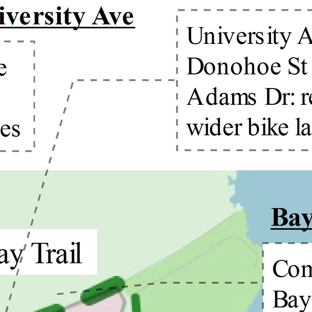

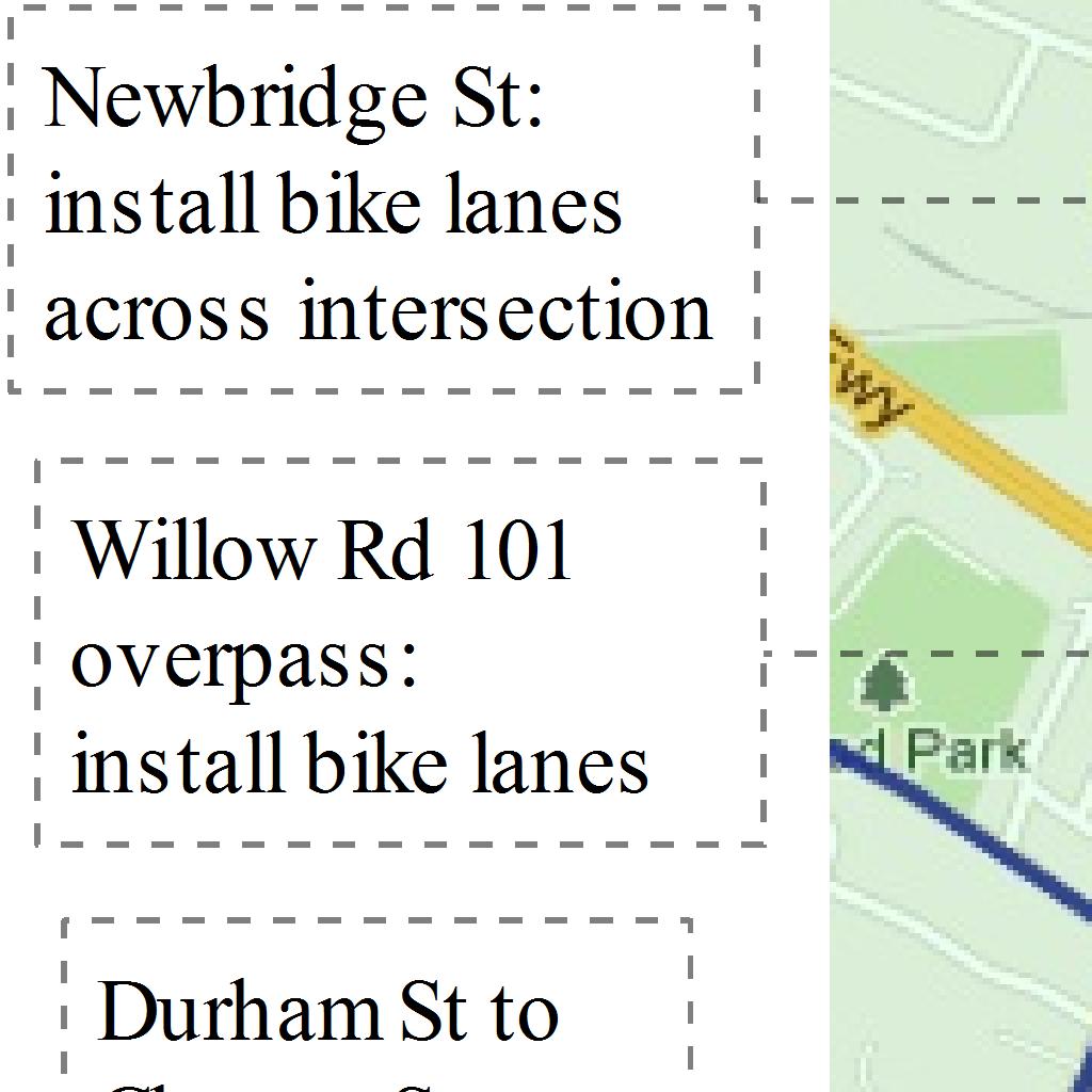
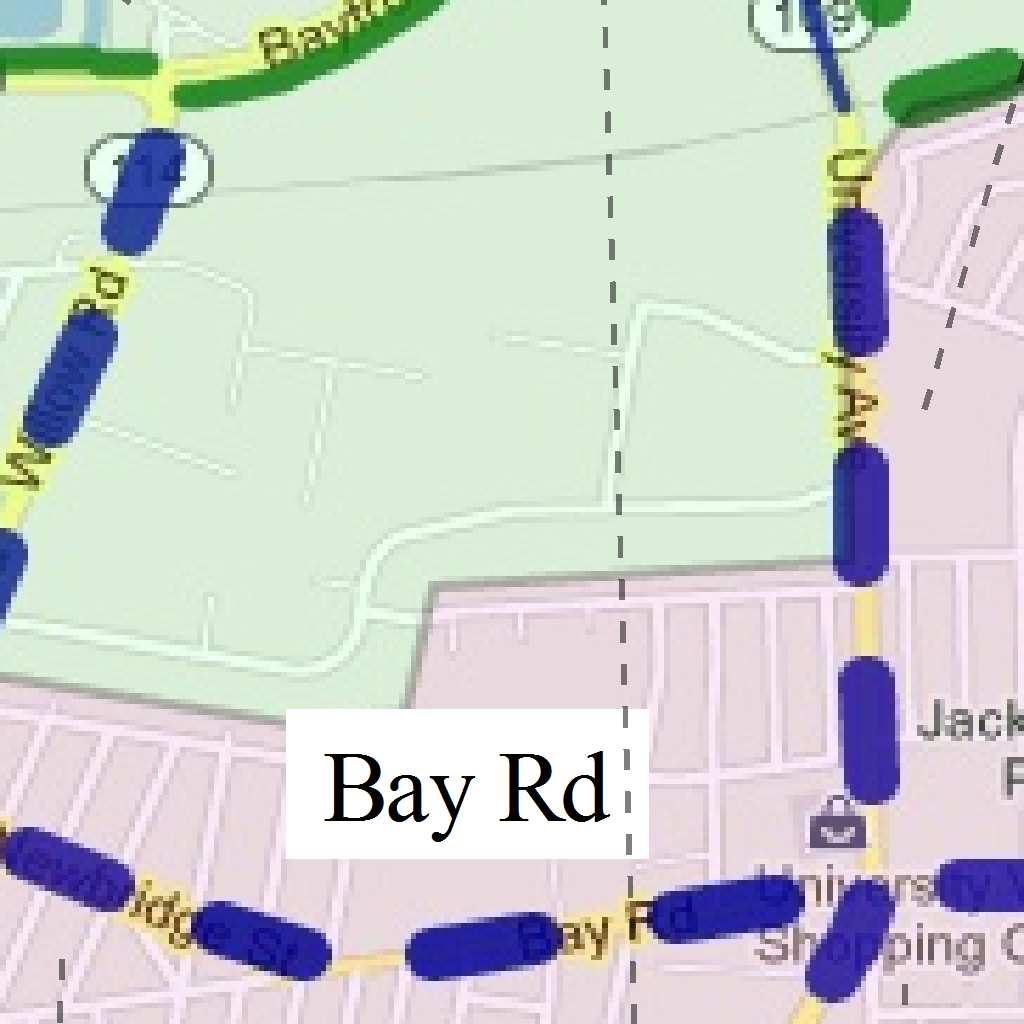
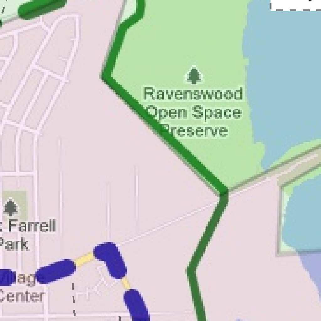

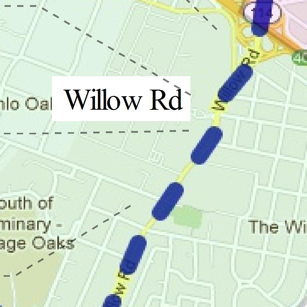
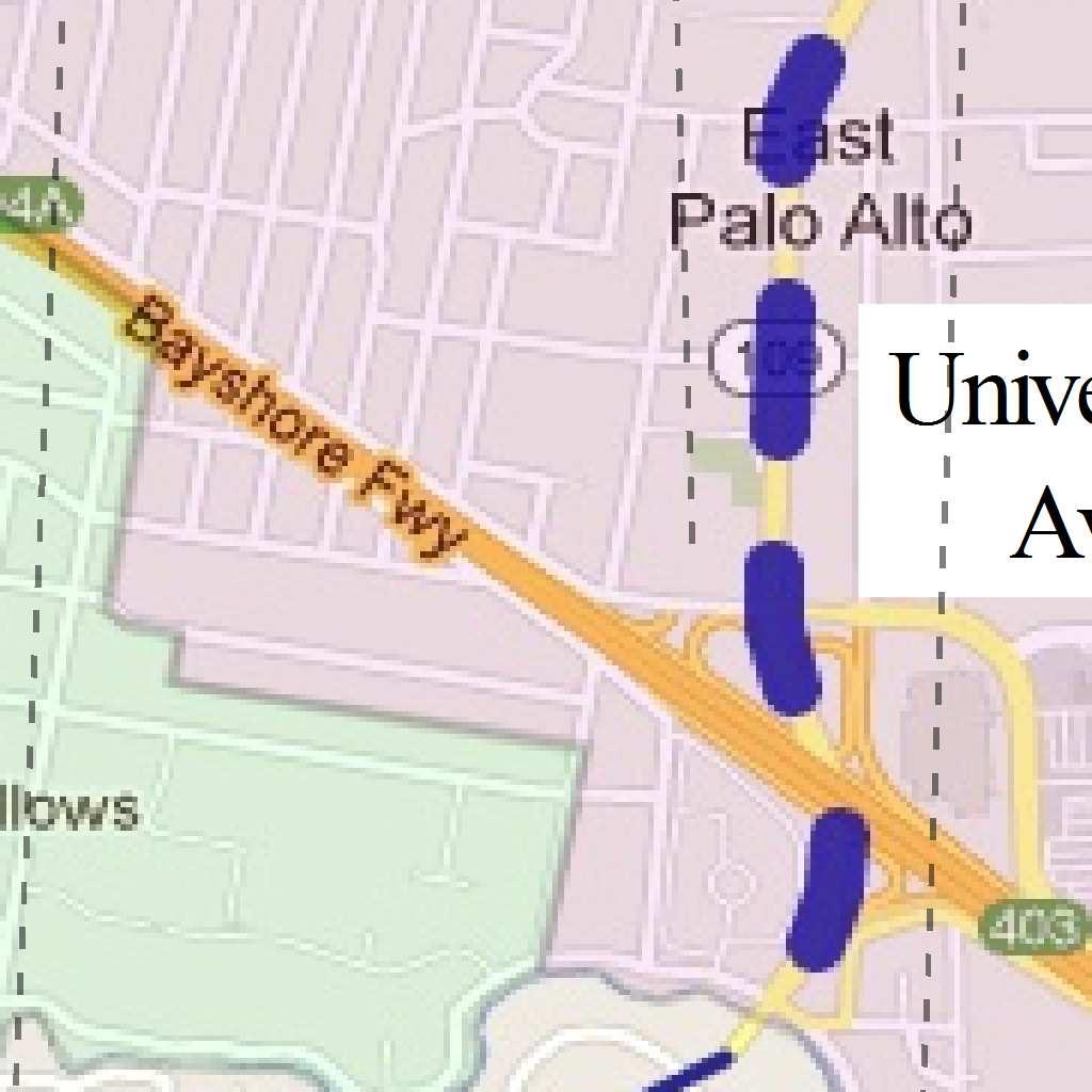


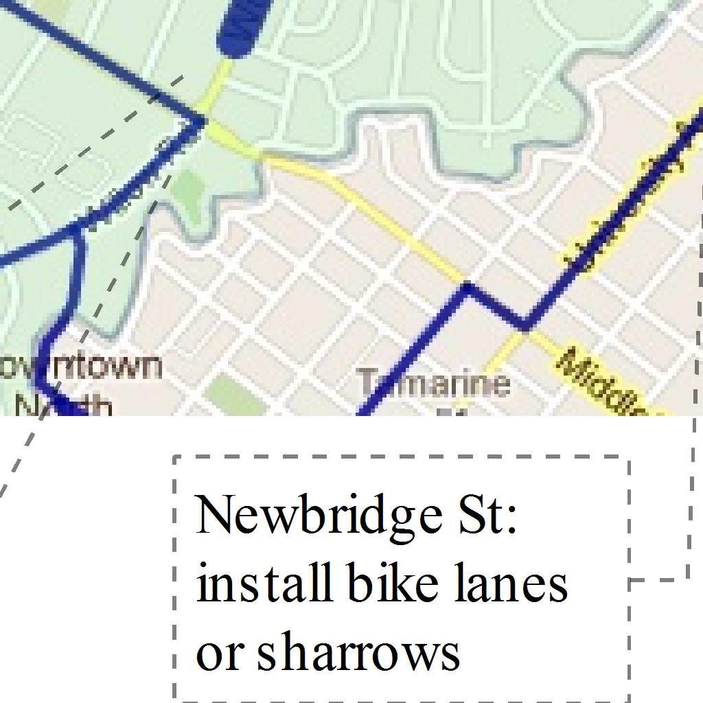
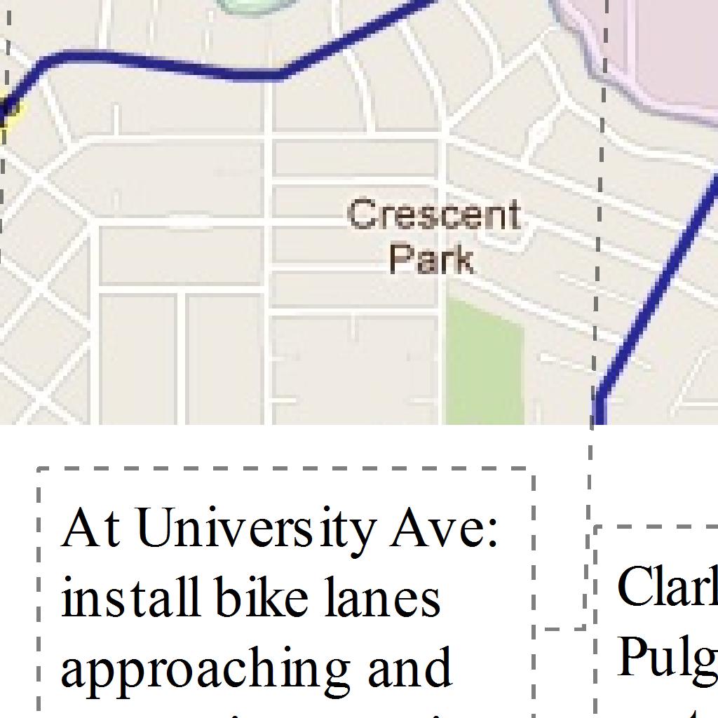
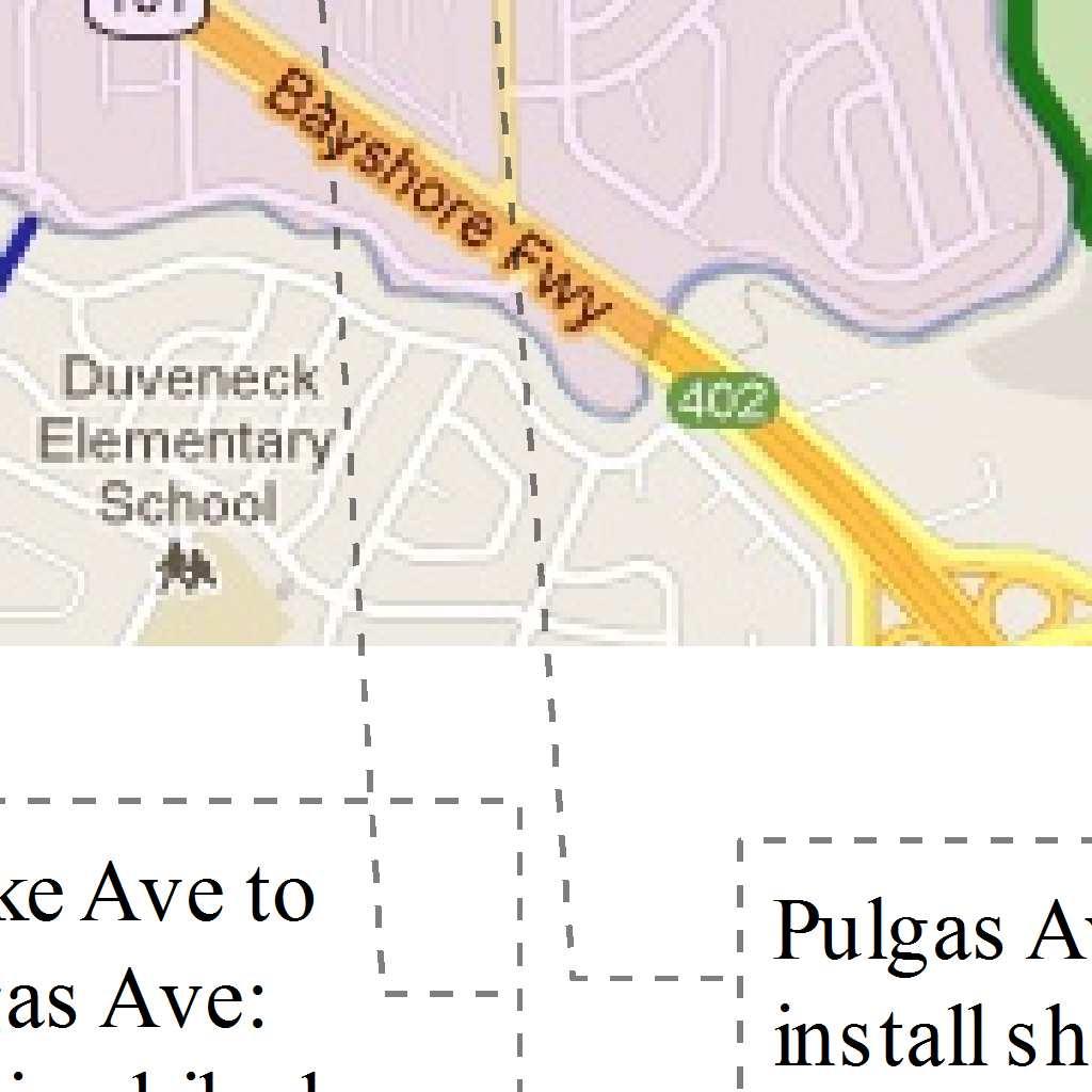

2 Silicon Valley Bicycle Coalition (SVBC) Proposed Improvements for Facebook Bicycle Commuters Safe, continuous bicycle accomodations (bike lanes or path) on: 1. Willow Rd from Middlefield Ave to Bayfront Exprwy 2. University Ave from Woodland Ave to Bayfront Exprwy 3. Bay Rd Route from Bay Trail to Willow Rd (Newbridge St, Bay Rd, Pulgas Ave) 4. Bay Trail from Bayfront Exprwy to Ravenswood Open Space District
3 Junipero Serra Boulevard/Campus Drive West [intersection #26] - LOS would change from E to F. The average critical delay would increased by 4.4 seconds and the V/C ratio would increase by This intersection would be significantly affected by the SUMC Project. Arboretum Road/Galvez Street [intersection #37] (unsignalized) - LOS would remain at F. Traffic signal warrants would be met at this intersection. This intersection would thus be significantly affected by the SUMC Project. Middlefield Road/Ravenswood Avenue [intersection #46] - LOS would change from D to E. This intersection would be significantly affected by the SUMC Project. Bayfront Expressway/Willow Road [intersection #52] - LOS would remain at F but at least one critical movement for this State-controlled, Menlo Park intersection would exceed 0.8 seconds. This intersection would be significantly affected by the SUMC Project. Bayfront Expressway/University Avenue [intersection #53] - LOS would remains at F but at least one critical movement for this State-controlled, Menlo Park intersection would exceed 0.8 seconds. This intersection would be significantly affected by the SUMC Project. Alpine Road/I-280 NB Off-Ramp [intersection #62] (unsignalized) - LOS would remain at F. Traffic signal warrants at this intersection are met at baseline conditions as well as with the SUMC Project. This intersection would be significantly affected by the SUMC Project. MITIGATION MEASURES. Given the magnitude of the SUMC Project s intersection impacts, there is no single feasible mitigation measure that can reduce the impacts to a less-thansignificant level. However, there are a range of measures that, when taken individually, would each contribute to a partial reduction in the SUMC Project s impacts. When combined, these measures could result in a substantial reduction in the SUMC Project s impacts. A set of five different mitigation measures were identified in the Transportation Impact Analysis. Each measure was then prioritized, the highest priority measure being the most preferable solution, and the lowest priority measure being the least preferable. The following are the five mitigation measures, ranked according to priority: Priority 1 mitigation measure Traffic-adaptive signal technology Priority 2 mitigation measure Additional bicycle and pedestrian undercrossings Priority 3 mitigation measure Enhanced transportation demand management (TDM) program Priority 4 mitigation measure Intersection improvements Priority 5 mitigation measure Remote employee parking lots near freeway interchanges Stanford University Medical Center Facilities Renewal and Replacement Draft EIR Transportation
4 Several of the Priority 4 mitigation measures would require the acquisition of additional rightof-way, and the construction of additional turn lanes. However, the City of Palo Alto has a stated policy which advocates a multi-modal approach to addressing traffic congestion as opposed to approaches that require an increase in roadway capacity. The City of Menlo Park is also trying to encourage commuters to use alternative modes of travel to the automobile. For these reasons, several of the Priority 4 measures are considered to be infeasible. Only those intersection improvements that are considered to be feasible were included in the analysis of the SUMC Project s impacts. The Priority 3 and Priority 5 measures would be alternatives to each other, both aimed at reducing the traffic impacts of the same target population, SUMC s longer distance commuters. They are viewed as either or measures, and would not be implemented together. The remote parking lot mitigation measure (Priority 5) was developed as an alternative to the enhanced TDM program. The discussion and analysis of this mitigation measure is included in Appendix D. The Priority 1 mitigation measure was analyzed first to determine to what extent it ameliorated the SUMC Project s impacts by itself. The Priority 1 mitigation measure was then combined with other lower priority mitigation measures to determine the combined impact reduction. The following combinations of mitigation measures are analyzed below: Priority 1 + Priority 2 Priority 1 + Priority 2 + Priority 3 Priority 1 + Priority 2 + Priority 3 + Priority 4 Traffic Adaptive Signal Technology. Traffic-adaptive signals were first implemented in Palo Alto along the Charleston-Arastradero corridor. This technology reduces overall intersection delay by sensing traffic movements as they approach the intersection and adjusting the signal indications to serve those vehicles. The City estimates that overall intersection delay can be reduced by up to 12 percent with the installation of traffic-adaptive signal technology. Mitigation Measure TR-2.1 requires Stanford University to make a fair-share financial contribution towards the implementation of traffic adaptive signals. The City has identified the following corridors for the implementation of traffic-adaptive signal technology: Sand Hill Road (Oak Creek to Shopping Center) - 4 signals Arboretum Road (Shopping Center to Palm Drive) - 3 signals Embarcadero Road (Bryant to Saint Francis) - 7 signals University Avenue (Palm to Lincoln) - 13 signals Lytton Avenue (Alma to Middlefield) - 10 signals Hamilton Avenue (Alma to Middlefield) - 10 signals Stanford University Medical Center Facilities Renewal and Replacement Draft EIR Transportation
5 Middlefield Road (San Antonio to Homer) - 9 signals Charleston Road (Alma to Middlefield) - 2 signals El Camino Real (northern city limits of Menlo Park to southern city limits of Palo Alto) signals would require approval of Caltrans In the AM Peak Hour, the intersection of El Camino Real/Page Mill Road-Oregon Expressway (intersection #16) would no longer be impacted with the implementation of traffic adaptive signal technology. However, the following four intersections would remain significantly impacted. El Camino Real/University Avenue Palm Drive [intersection #10] Santa Cruz Avenue/Sand Hill Road [intersection #30] Arboretum Road/Galvez Street [intersection #37] Alpine Road/I-280 northbound off-ramp [intersection #62] In the PM Peak Hour, implementation of traffic adaptive signal technology would alleviate impacts at the following three intersections. El Camino Real/Ravenswood Avenue [intersection #3] El Camino Real/Page Mill Road-Oregon Expressway [intersection #16] Middlefield Road/Lytton Avenue [intersection #19] However, the following nine intersections would remain significantly impacted. El Camino Real/University Avenue-Palm Drive [intersection #10] Middlefield Road/Willow Road [intersection #18] Junipero Serra Boulevard Foothill Expressway/Page Mill Road [intersection #23] Junipero Serra Boulevard/Campus Drive West [intersection #26] Arboretum Road/Galvez Street [intersection #37] Middlefield Road/Ravenswood Avenue [intersection #46] Bayfront Expressway/Willow Road [intersection #52] University Avenue/Bayfront Expressway [intersection #53] Alpine Road/I-280 northbound off-ramp [intersection #62] New Bicycle and Pedestrian Undercrossings. In addition to the existing undercrossings at University Avenue and Homer Avenue, two new bicycle and pedestrian undercrossings would be constructed in the Study Area in the future. One would be near Everett Avenue in Palo Alto Stanford University Medical Center Facilities Renewal and Replacement Draft EIR Transportation
6 Stanford University Medical Center EIR, Chapter 3.4 Transportation, pages to and the other would be near Middle Avenue in Menlo Park. These additional undercrossings north of University Avenue would facilitate walking and bicycling from residential and commercial areas in north Palo Alto and south Menlo Park. Mitigation Measure TR-2.2 requires Stanford University to make a fair-share financial contribution towards the construction of the Everett Avenue and Middle Avenue undercrossings. Based on the traffic distribution percentages that are based on SUMC employee zip codes, the number of existing employees living in the vicinity of the four bicycle and pedestrian undercrossings for SUMC would be approximately 625. Based on a mode split of six percent, 37 existing SUMC employees would bike or walk to the SUMC Sites. The existing mode split of 3.1 percent to bicycle and walk for hospital employees would be doubled (to six percent) to account for two existing undercrossings increasing to four. In the future, if the percentage would double to 12 percent, the number of existing employees who walk or bike to the SUMC Sites would be 75. The number of new SUMC Project employees in 2025 would be 2, The number of employees coming from the vicinity of the four undercrossings would be 173 in Based on the future mode split (12 percent), the number of new SUMC Project employees who would use these facilities would be 21 in Up to 96 employees, in total, from the SUMC would use the four bicycle and pedestrian undercrossings in the Study Area in 2025, when the SUMC Project would be at its full buildout. Consequently, the overall reduction of SUMC Project vehicular traffic trips during the AM/PM Peak Hour would be 23 trips in In addition to the existing and future SUMC traffic that can be reduced by the added undercrossings, existing and future traffic to and from the larger University would also benefit from the added undercrossings. The Peak Hour reduction in 2025 for hospital traffic calculated above represents about three percent of the total SUMC Project traffic. A similar adjustment has been applied to non-project traffic using the adjacent street network to gauge the true benefit of the new undercrossings. In the AM Peak Hour, combining bicycle and pedestrian undercrossings (Mitigation Measure TR-2.2) with traffic adaptive signal technology (Mitigation Measure TR-2.1) would reduce the SUMC Project s impacts at one additional intersection. In addition to the intersection of El Camino Real and Page Mill Road Oregon Expressway, the intersection of El Camino Real and University Avenue Palm Drive would also no longer be impacted. 10 For the purposes of determining usage of bicycle and pedestrian undercrossings, a slightly higher number of employees (2,311) are used than is shown in Section 2, the Project Description (2,242 employees). As a result, this analysis provides a conservative usage of bicycle and pedestrian undercrossings. Employment used here is based on the following memorandum: Fehr & Peers Transportation Consultants, Analysis of GO Pass Program for Hospital Employees, September 22, 2008, pp See Appendix H to the Transportation Impact Analysis. Stanford University Medical Center Facilities Renewal and Replacement Draft EIR Transportation
7 Menlo Park Transportation Impact Analysis Guidelines, pages 6 and 7 H. Analyze project using the requirements outlined in the San Mateo County Congestion Management Plan Land Use Analysis Program guidelines, if applicable. VI. Mitigation A. Discuss specific mitigation measures in detail to address significant impacts, which may occur as a result of the addition of project traffic (provide table comparing before and after mitigation). Analysis shall focus on mitigating significant impacts to a non-significant level, but must also identify measures, which would reduce adverse, although not significant, impacts. All feasible and reasonable mitigation requirements that could reduce adverse impacts of the project should be identified, whether or not there are significant impacts caused by the project. The goal of mitigation should be such that there are no net adverse impacts on the circulation network. Mitigation measures may include roadway improvements, operational changes, Transportation Demand Management or Transportation Systems Management measures, or changes in the project. If roadway or other operational measures would not achieve this objective, the consultant shall identify a reduction in the project size, which would with other measures, reduce impacts below the significant level. All mitigation measures must first be discussed with the City Transportation Division before they are included in the report. B. Discuss possible mitigation measures to address future traffic conditions with the project. All feasible and reasonable mitigation measures that would reduce such impacts, whether at the significant level or below shall be identified. Mitigation measures should be designed to address the project s share of impacts. Measures that should be jointly required of the project and any other on-going related projects in a related geographical area should also be identified, as applicable. C. Discuss possible mitigation measures to address any site circulation or access deficiencies. D. Discuss possible mitigation measures to address any parking deficiencies. E. Discuss possible mitigation measures to address any impacts on pedestrian amenities, bicycle access, safety and bus/shuttle service. VII. Alternatives A. In the event any potentially significant impacts are identified in the Transportation Impact Analysis, alternatives to the proposed project shall be evaluated or considered to determine what the impacts of an alternative project or use might be. The alternatives to be considered shall be determined in consultation with the Director of Community Development and the Transportation Manager. VIII. Summary and Conclusions A. Assess level of significance of all identified impacts after mitigation. Page 6 of 7
8 Upon receipt by the City of a Transportation Impact Analysis indicating that a project may have potentially significant traffic impacts, the applicant shall have the option of proceeding directly with the preparation of an EIR in accordance with the City s procedures for preparation of an EIR, or requesting a determination by the City Council as to whether a negative declaration, mitigated negative declaration or an EIR is most appropriate for the project. NOTES: 1. The Highway Capacity Manual Special Report 209 (HCM), latest version shall be used for intersection analysis. The consultant shall use the Citywide TRAFFIX model with the HCM analysis. 2. The most recent Circulation System Assessment (CSA) shall be used for all information regarding existing and near term conditions. 3. Traffic counts that may be required beyond the counts contained in the CSA document shall be less than 6 months old. 4. The consultant shall submit proposed assumptions to the Transportation Manager for review and approval prior to commencement of the Analysis relating to the following: 1. trip rates 2. trip distribution 3. trip assignment 4. study intersections 5. roadways to be analyzed 4. The consultant shall submit all traffic count sheets to the City s Transportation Division. 5. Figures of existing and any proposed intersection configurations should be provided in the appendix. 6. Trip generation rates from Institute of Transportation Engineer s (ITE) publication, TRIP Generation, latest version should be used. 7. Street widening and on-street parking removal are mitigation measures which may be technically feasible, but which are generally considered undesirable. If such measures appear potentially appropriate to the consultant, they should consult the Transportation Division in preparing the impact analysis and mitigation recommendations. If such measures are to be proposed, alternate mitigation measures, which would be equally effective, should also be identified. 8. Existing uses at the site, which would be removed as part of the project, may be deducted from the calculation of the project traffic based on their traffic distribution patterns. 9. Refer to the San Mateo County Congestion Management Program (CMP) Land Use Impact Analysis Program guidelines for performing CMP analysis. Page 7 of 7
9 Subject: Mitigation Measures in Facebook Campus Draft EIR To: Menlo Park Transportation Commission From: Andrew Boone Date: Jan 11, 2012 Facebook s goal is to reduce vehicle trips Facebook has proposed a vehicle trip cap to reduce trips to its campus. Hopefully, this will ensure that these alternative modes of transportation are used by more employees. Since the goal of the Trip Cap is to reduce vehicle trips, the goal of the mitigation measures proposed in the Draft Environmental Impact Report (Draft EIR) should also be to reduce vehicle trips. Auto-oriented Mitigation Measures in the Draft EIR However, all of the mitigation measures proposed in the Facebook Campus Draft EIR (pages and ) are likely to increase vehicle trips, because they would add vehicle lanes on roadways and at intersections, or make other modifications designed to increase roadway capacity (such as re-striping a through lane as a turn-and-through lane). Wider roads with more vehicle lanes will not only encourage more workers to drive, they will discourage alternative modes such as bicycling and walking because streets will be less safe to cross, and because the streets will contain more vehicle traffic. The Draft EIR proposes seven new turn lanes to mitigate auto traffic at intersections. Five of these add width to the roadway, creating longer crossing distances for pedestrians. This has been documented in safety studies to increase the rate of pedestrian injuries. All of the proposed additional turn lanes reduce visibility between motorists and pedestrians. One of the additional turn lanes (at Willow Rd & Middlefield Rd) removes a pedestrian refuge island. Menlo Park City Policy regarding mitigation measures Section VI. A. of the Menlo Park Transportation Impact Analysis (TIA) Guidelines states that Analyses shall focus on mitigating significant impacts to a non-significant level, but must also identify measures, which would reduce adverse, although not significant, impacts. This implies that mitigation measures must be identified even for intersections and roadways that are not impacted above the threshold of significance. Section VI.A. continues: All feasible and reasonable mitigation measures, whether at the significant level or below shall be indentified. Is a bike lane feasible and reasonable? A completed bike path? Additional shuttle service? Improved crosswalks for pedestrians? If so, then the city s policy (the TIA) states that they shall be identified. No such mitigation measures have been identified in the Facebook Campus EIR. Note 7 on page 7 states Street widening and on-street parking removal are mitigation measures which may be technically feasible, but which are generally considered undesireable.
10 If widening streets is considered undesirable, why do so many of the transportation mitigation measures in the Facebook Draft EIR propose to do exactly that, instead of considering alternatives? The City of Menlo Park s Traffic Impact Fee Program states...roadway widening is not a feasible option for roadways in Menlo Park. Therefore, other alternative mitigations were considered to encourage vehicular traffic to shift to other modes of transportation, including pedestrian, bicycle and transit. ( page 5) Again, if roadway widening is not a feasible option, why are so many of the transportation mitigation measures exactly that? CEQA requires consideration of non-auto mitigation measures Section of the California Environmental Quality Act (CEQA) Guidelines states that Where several measures are available to mitigate an impact each should be discussed and the basis for selecting a particular measure should be identified. Are several measures (such as bike lanes or improved crosswalks) available to mitigate a transportation impact? If so, then each should be discussed. Many mitigation measures are available that have not been discussed in the Facebook Campus Draft EIR. Stanford University Medical Center EIR Prioritized Mitigation Measures The Stanford University Medical Center (SUMC) EIR is a great example of complying and EIR that complies with CEQA Guidelines, because several mitigation measures are available, and each are discussed. Transportation mitigation measures were prioritized based on the goal of reducing vehicle trips and promoting travel alternatives to the automobile. This fulfills the CEQA requirement to identify the basis for selecting a particular mitigation measure. From Highest to Lowest priority were: 1.Traffic-adaptive signal technology 2. Additional bicycle and pedestrian undercrossings 3. Enhanced Transportation Demand Management (TDM) program 4. Intersection Improvements (meaning additions of vehicle lanes) 5. Remote Employee parking lots near freeway interchanges What was the basis for prioritizing Intersection Improvements only 4th out of 5 identified categories of mitigation measures? One reason was Menlo Park s own goals, as stated in the SUMC EIR: The City of Menlo Park is also trying to encourage commuters to use alternative modes of travel to the automobile. For these reasons, several of the Intersection Improvements are considered to be infeasible. ( page ) Frequently Asked Questions
11 But wouldn t considering non-auto mitigation measures expose Menlo Park to legal liability? No. In fact, by not discussing such mitigation measures, Menlo Park is currently exposed to legal liability with the Facebook Draft EIR, since the CEQA Guidelines require that where several measures are available, each be discussed, and that the basis for choosing a measure is included. The SUMC EIR, for example, satisfied this requirement by prioritizing of mitigation measures, thus protecting Palo Alto from legal liability. But aren t some of these mitigation measures, such as bicycle improvements, impossible to quantify? Methods and data to do such calculations don t exist. That s not correct. In fact, the SUMC EIR quantifies the reduction in the number of vehicle trips, at multiple intersections, as a result of two new bicycle/pedestrian undercrossings of Caltrain - including one near Middle Ave in Menlo Park. It also quantifies the reduction in vehicle trips as a result of improved transit service. There is plenty of data from similar projects to be able to quantify the reduction in auto trips that a given bicycle, pedestrian, or transit improvement would result in. For example, the Moffett Field section of the Bay Trail was recently completed in Mountain View, and bicycle commuting to the Moffett Business Park then increased. Fewer vehicle trips were made through the intersections approaching those businesses. Data from this example exists, and this is just one example. But don t mitigation measures have to be physically located at the intersection for which the impact is quantified? No. The CEQA Guidelines nor the city s Transportation Impact Analysis (TIA) Guidelines do not make such a statement. If you can find this somewhere, please let me know! The bicycle/pedestrian tunnel under Caltrain at Middle Ave in Menlo Park is one such example of a mitigation measure not being located at the impacted intersections. This project was used to partially mitigate transportation impacts at the intersections of El Camino Real & Page Mill Rd and El Camino Real & University Ave, both in Palo Alto ( blobdload.asp?blobid=20178, page ). These intersections are located 0.9 and 2.7 miles from the Middle Ave undercrossing, respectively. This is irrelevant because It is the creation of a safe and convenient route to the SUMC that results in more employees cycling to work and thus not driving through the impacted intersections. Also, for improved transit service, which is a common transportation mitigation measure in many EIRs including the SUMC EIR, it being physically located at any one intersection makes no logical sense. Transit service, by definition, is not located at any point, but instead transports people from one place to another, thus allowing them to avoid driving through the intersection in question. But how would mitigation measures such as bike lanes reduce the impact at a given intersection to a less than significant level? Isn t that required for them to be incuded? No. Partial mitigation measures are common in EIRs, because it often occurs that no single mitigation measure is available to reduce an impact below the level of significance. Instead, many separate mitigation measures can be used. The SUMC EIR mitigation measures are based the principle of partial mitigation - each measure contributes its share to help mitigate the impacts. What about mitigation measures outside the jurisdiction of Menlo Park? Can the Facebook EIR include bike lanes or a bike path in East Palo Alto, for example? Yes. In fact, the Facebook Draft EIR currently does includes many mitigation measures outside of Menlo Park s jurisdiction, including one in East Palo Alto - an additional right-turn only lane at
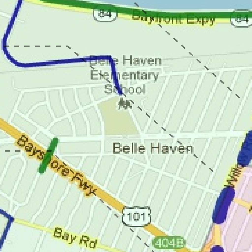
12 University Ave & Donohoe St (page ). So what alternative mitigation measures should be included in the Facebook EIR? There are many feasible and reasonable measures available to mitigate Facebook s transportation impacts that are consistent with city policy and would support Facebook s goal to reduce vehicle trips. These should be discussed in the EIR. Bicycle Improvements: 1. Complete the entire missing one-mile section of the Bay Trail through Menlo Park and East Palo Alto, which would create a network of 35 miles of continuous bike paths connecting Facebook to Palo Alto, Mountain View, Sunnyvale, Santa Clara, and San Jose. About 40% of Facebook employees live in these cities, so this project would be especially beneficial to mitigate transportation impacts. 2. Fill in the gaps in the bike lanes on Willow Rd from Middlefield Rd to Bayfront Exprwy, including the Highway 101 overpass, thus creating a safe and direct cycling route from downtown Menlo Park to Facebook 3. Fill in the gaps in the bike lanes on University Ave from Woodland Ave to Bayfront Exprwy, including the Highway 101 overpass, thus creating a safe and direct cycling route from north Palo Alto to Facebook 4. Fill in the gaps in the bike lanes on the Bay Rd Route (Pulgas Ave, Bay Rd, and Newbridge St) from where the paved section of the Bay Trail ends at Runnymede St to Willow Rd & Newbridge St, thus creating a safe route with lower traffic speeds and volumes for less confident and experience cyclists who are uncomfortable cycling on University Ave Transit Improvements: 1. Open Facebook s private shuttles that travel between the Menlo Park and Palo Alto Caltrain stations to public use, thus augmenting the existing transit service available to Belle Haven residents, allow them to reach Caltrain and thus employment destinations more quickly and conveniently. Stanford University s Marguerite shuttle system operates in exactly this manner. Pedestrian Improvements 1. Install high-visibility crosswalks at intersections on Willow Rd in Belle Haven, including Willow & Bayfront, Willow & Hamilton, Willow & Ivy, and Willow & Newbridge. These intersections are all within walking distance of the Facebook Campus. 2. Expand the size of the two pedestrian refuge islands at the intersection of Willow Rd & Bayfront Exprwy and place some type of barrier on their edges to provide increased visibility to passing motorists. 3. Install high-visibility crosswalks on the north and east sides of the intersection of Willow Rd & Bayfront Exprwy to increase pedestrian safety and convenience.
13 4. Install a sidewalk on the east side of Hacker Way at the entrance to the Facebook Campus. Any others? Perhaps other members of the public can think of some other feasible and reasonable transportation mitigation measures that would help Facebook commuters get to work safely and benefit the community as well. Conclusion The transportation mitigation measures proposed in the Facebook Draft EIR could be expanded to help Facebook meet its goal for reducing vehicle trips to its campus. Adding vehicle lanes works against this goal - it encourages more driving, and at the same time discourages bicycling and walking due to reduced safety. This is inconsistent with Goal II-C of the Transportation Element of Menlo Park s General Plan, which is To promote the use of alternatives to the single occupant automobile. Adding bicycle, transit, and pedestrian oriented mitigation measures to the mitigation measures currently proposed would help both Facebook and Menlo Park achieve their goals more effectively. - Andrew Boone, nauboone@gmail.com
FROM: CITY MANAGER DEPARTMENT: PLANNING AND COMMUNITY ENVIRONMENT DATE: OCTOBER 4, 2004 CMR:432:04
 TO: HONORABLE CITY COUNCIL FROM: CITY MANAGER DEPARTMENT: PLANNING AND COMMUNITY ENVIRONMENT DATE: OCTOBER 4, 2004 CMR:432:04 SUBJECT: FINANCE COMMITTEE RECOMMENDATION TO ADOPT TRANSPORTATION STRATEGIC
B. TRANSPORTATION, CIRCULATION AND PARKING
 FEBRUARY 0 89 EL CAMINO REAL PROJECT EIR This section describes the existing traffic, circulation, parking, and transit conditions in the vicinity of the project site and provides an analysis of the project
Magnolia Place. Traffic Impact Analysis. Prepared for: City of San Mateo. Prepared by: Hexagon Transportation Consultants, Inc.
 Magnolia Place Traffic Impact Analysis Prepared for: City of San Mateo Prepared by: Hexagon Transportation Consultants, Inc. Updated January 4, 2010 Table of Contents 1. Introduction...1 2. Existing Conditions...6
Los Altos Hills Town Council - June 18, 2015 Palo Alto City Council June 22, AGENDA ITEM #2.B Presentation
 Los Altos Hills Town Council - June 18, 2015 Palo Alto City Council June 22, 2015 AGENDA ITEM #2.B Presentation Previous Presentations Los Altos Hills Town Council in May 2014 and February 2015 Palo Alto
TRANSPORTATION TRAINING TOPICS. April 6, 2010
 TRANSPORTATION TRAINING TOPICS April 6, 2010 Roles of Transportation Providers Context and Policy Makers Division of Transportation and Traffic Other City Operations Other Transportation Operators CMA
Bike San Mateo County San Mateo County Bicycle Plan Recommendations August 30, 2010
 Policy and Procedures Develop and Implement a Complete Streets Policy to comply with DD-64-R1 and AB1358 Commencing January 1, 2011, AB1358 requires that the legislative body of a city or county, upon
SANTA CLARA COUNTYWIDE BICYCLE PLAN August 2008
 SANTA CLARA COUNTYWIDE BICYCLE PLAN August 2008 To assist VTA and Member Agencies in the planning, development and programming of bicycle improvements in Santa Clara County. Vision Statement To establish,
REVIEW OF LOCAL TRAFFIC FLOW / LONG RANGE PLANNING SOLUTIONS STUDY
 ITEM Town of Atherton TRANSPORTATION COMMITTEE STAFF REPORT TO: FROM: MEMBERS OF THE COMMITTEE ROBERT OVADIA, PUBLIC WORKS DIRECTOR DATE: FEBRUARY 12, 2019 SUBJECT: REVIEW OF LOCAL TRAFFIC FLOW / LONG
D.13 Transportation and Traffic
 This section addresses transportation and traffic issues and impacts related to the Proposed Project. Section D.13.1 provides a description of the affected environment for the Proposed Project. Applicable
Mission Street Medical Office Development
 reet Medical Office Development Traffic Impact Analysis Prepared for: Palo Alto Medical Foundation February 23, 2012 Hexagon Office: 7888 Wren Avenue, Suite B121 Gilroy, CA 95020 Hexagon Job Number: 11RD11
COMMUNITY MEETING AGENDA
 COMMUNITY MEETING AGENDA Welcome and Introductions SAFE Presentation Project Presentation Priorities Feedback Next Steps Q&A Santa Cruz Avenue Corridor Study 1 Santa Cruz Avenue Corridor Study Community
REQUIREMENTS FOR TRAFFIC CONTROL PLAN SUBMISSION
 REQUIREMENTS FOR TRAFFIC CONTROL PLAN SUBMISSION A draft traffic control plan, consistent with the following applicable conditions, must be included in every permit application submitted to the City of
This document may be reprinted or extracted without permission, provided credit to the City of Pasadena Department of Transportation
 TRANSPORTATION IMPACT ANALYSIS CURRENT PRACTICE & GUIDELINES Prepared by: Transportation Complete Streets Division Department of Transportation 20150925 This document may be reprinted or extracted without
TRANSPORTATION MASTER PLAN Review Citywide Recommendations, Updated List and Scoring Methodology December 6, 2018
 NOTE: Due to lengthy Committee discussion and allotted meeting time, slides 12-35 were not presented at the meeting, but are provided here for reference. TRANSPORTATION MASTER PLAN Review Citywide Recommendations,
4.13 TRANSPORTATION AND TRAFFIC
 4.13 This chapter describes the regulatory framework and existing conditions in the vicinity of the Project site related to transportation and traffic, and the potential impacts of the proposed Project
Average Delay/Vehicle (sec/veh) Signalized. Unsignalized Intersection
 Signalized. Unsignalized Intersection") Attachment: Traffic Analysis Results Traffic simulation modeling analysis was completed for Santa Cruz Ave from Alameda De Las Pulgas to Junipero Serra Blvd. Analysis was performed for existing conditions
Attachment: Traffic Analysis Results Traffic simulation modeling analysis was completed for Santa Cruz Ave from Alameda De Las Pulgas to Junipero Serra Blvd. Analysis was performed for existing conditions
EXECUTIVE SUMMARY... vii 1 STUDY OVERVIEW Study Scope Study Area Study Objectives
 Contents EXECUTIVE SUMMARY... vii 1 STUDY OVERVIEW... 1-1 1.1 Study Scope... 1-1 1.2 Study Area... 1-1 1.3 Study Objectives... 1-3 2 EXISTING CONDITIONS... 2-1 2.1 Existing Freeway Conditions... 2-4 2.1.1
Santa Clara I-280 CORRIDOR STUDY
 Santa Clara I-280 CORRIDOR STUDY OCTOBER 2017 PREPARED BY: 1.1 Background The I-280 Corridor Study within Santa Clara County is a high-level highway planning study led by the Santa Clara VTA, in partnership
Complete Street Analysis of a Road Diet: Orange Grove Boulevard, Pasadena, CA
 Complete Street Analysis of a Road Diet: Orange Grove Boulevard, Pasadena, CA Aaron Elias, Bill Cisco Abstract As part of evaluating the feasibility of a road diet on Orange Grove Boulevard in Pasadena,
Solana Beach Comprehensive Active Transportation Strategy (CATS)
") Solana Beach Comprehensive Active Transportation Strategy (CATS) 3.0 Goals & Policies The Solana Beach CATS goals and objectives outlined below were largely drawn from the Solana Beach Circulation Element
Solana Beach Comprehensive Active Transportation Strategy (CATS) 3.0 Goals & Policies The Solana Beach CATS goals and objectives outlined below were largely drawn from the Solana Beach Circulation Element
TRAFFIC STUDY GUIDELINES Clarksville Street Department
 TRAFFIC STUDY GUIDELINES Clarksville Street Department 9/1/2009 Introduction Traffic studies are used to help the city determine potential impacts to the operation of the surrounding roadway network. Two
3.3 Transportation/Traffic
 3.3 This section provides an evaluation of traffic and transportation related to the proposed Commonwealth Corporate Center Project. The Project site is accessible from Commonwealth rive and Jefferson
4. ENVIRONMENTAL IMPACT ANALYSIS 9. TRANSPORTATION AND TRAFFIC
 4. ENVIRONMENTAL IMPACT ANALYSIS 9. TRANSPORTATION AND TRAFFIC 4.9.1 INTRODUCTION The following section addresses the Proposed Project s impact on transportation and traffic based on the Traffic Study
Purpose and Need. Chapter Introduction. 2.2 Project Purpose and Need Project Purpose Project Need
 Chapter 2 Purpose and Need 2.1 Introduction The El Camino Real Bus Rapid Transit (BRT) Project (Project) would make transit and other transportation improvements along a 17.6-mile segment of the El Camino
3.9 - Transportation and Traffic
 Transportation and Traffic 3.9 - Transportation and Traffic This section describes the potential transportation and traffic effects of project implementation on the project site and its surrounding area.
Appendix T CCMP TRAIL TRAFFIC & TRANSPORTATION DESIGN STANDARD
 Appendix T CCMP 3.3.4 TRAIL TRAFFIC & TRANSPORTATION DESIGN STANDARD 3.3.4 Trail Traffic and Transportation Design Multi-use trails have certain design standards, which vary depending on the agency that
Development Review Program Annual Report 2016
 Development Review Program Annual Report 2016 Web version Spring 2017 http://museumplacesanjose.com/ http://www.elcaminohospital.org City of Campbell Council Agenda Packet 9/13/16 Gunter Lofts Development
Bicycle Master Plan Goals, Strategies, and Policies
 Bicycle Master Plan Goals, Strategies, and Policies Mobilizing 5 This chapter outlines the overarching goals, action statements, and action items Long Beach will take in order to achieve its vision of
EL CAMINO REAL BUS RAPID TRANSIT (BRT) PROJECT
 PROJECT") Agenda Item #4.2 EL CAMINO REAL BUS RAPID TRANSIT (BRT) PROJECT VTA BOARD WORKSHOP MAY 1, 2015 ABOUT THIS PRESENTATION CONTEXT Existing conditions and planning for growth WHAT IS THE PROJECT? Project alternatives
Agenda Item #4.2 EL CAMINO REAL BUS RAPID TRANSIT (BRT) PROJECT VTA BOARD WORKSHOP MAY 1, 2015 ABOUT THIS PRESENTATION CONTEXT Existing conditions and planning for growth WHAT IS THE PROJECT? Project alternatives
AGENDA ITEM G-2 Public Works
 AGENDA ITEM G-2 Public Works STAFF REPORT City Council Meeting Date: 12/6/2016 Staff Report Number: 16-214-CC Regular Business: Approve the Oak Grove University Crane Bike Improvement Concept Plan, authorize
San Jose Transportation Policy
 San Jose Transportation Policy Protected Intersections in LOS Policies to Support Smart Growth Presented by: Manuel Pineda City of San Jose Department of Transportation Bay Area Map San Francisco Oakland
San Mateo County Comprehensive Bicycle and Pedestrian Plan Open House
 San Mateo County Comprehensive Bicycle and Pedestrian Plan Open House October 28, 2010 Presented to San Mateo County residents and interested parties by Lauren Ledbetter, Alta Planning + Design Matt Haynes,
CITY OF LOS ANGELES INTER-DEPARTMENTAL MEMORANDUM
 CITY OF LOS ANGELES INTER-DEPARTMENTAL MEMORANDUM Date: April 1, 219 To: Honorable City Council c/o City Clerk, Room 395, City Hall Attention: Honorable Mike Bonin, Chair, Transportation Committee From:
Vision. 3 Transportation. Introduction. Statement
 3 Transportation Vision Statement Palo Alto will provide accessible, attractive, economically viable and environmentally sound transportation options that meet the needs of residents, employers, employees
Route 7 Corridor Study
 Route 7 Corridor Study Executive Summary Study Area The following report analyzes a segment of the Virginia State Route 7 corridor. The corridor study area, spanning over 5 miles in length, is a multi
San Mateo County Comprehensive Bicycle and Pedestrian Plan
 San Mateo County Comprehensive Bicycle and Pedestrian Plan August 26, 2010 Presented to the San Mateo County BPAC by Lauren Ledbetter, Alta Planning + Design in association with: Fehr & Peers Eisen Letunic
June 3, Attention: David Hogan City of San Mateo 330 W. 2oth Avenue San Mateo, CA 94403
 June 3, 2015 Attention: David Hogan City of San Mateo 330 W. 2oth Avenue San Mateo, CA 94403 Regarding: PA # 15-030, Bridgepointe Shopping Center 2202 Bridgepointe Parkway, APN 035-466-10 Dear David: Enclosed
1.0 INTRODUCTION 1.1 PURPOSE OF THIS REPORT
 1.0 INTRODUCTION This chapter provides an overview of the purpose, authorization and focus of this Recirculated Draft Environmental Impact Report (EIR), an identification of the Lead Agency, an outline
Bridge Street Corridor Study Report
 Bridge Street Corridor Study Report Prepared for: Prepared by: BRIDGE STREET CORRIDOR STUDY REPORT PREPARED FOR: CITY OF ARROYO GRANDE COMMUNITY DEVELOPMENT DEPARTMENT 300 EAST BRANCH STREET ARROYO GRANDE,
TABLE OF CONTENTS TABLE OF CONTENTS... I APPENDICES... III LIST OF EXHIBITS... V LIST OF TABLES... VII LIST OF ABBREVIATED TERMS...
 TABLE OF CONTENTS TABLE OF CONTENTS... I APPENDICES... III LIST OF EXHIBITS... V LIST OF TABLES... VII LIST OF ABBREVIATED TERMS... IX 1 INTRODUCTION... 1 1.1 Project Overview... 1 1.2 Analysis Scenarios...
Figure 1: East West Connector Alignment Alternatives Concept Drawing
 Page 2 of 9 Figure 1: East West Connector Alignment Alternatives Concept Drawing The Montebello Drive extension will run north south and connect Wilsonville Road to the Boones Ferry Road to Brown Road
TRAFFIC IMPACT ANALYSIS
 TRAFFIC IMPACT ANALYSIS FOR THE CHAMPAIGN UNIT#4 SCHOOL DISTRICT PROPOSED HIGH SCHOOL (SPALDING PARK SITE) IN THE CITY OF CHAMPAIGN Final Report Champaign Urbana Urbanized Area Transportation Study 6/24/2014
Lincoln Avenue Road Diet Trial
 Lincoln Avenue Road Diet Trial Data Collection Report June 1, 2015 Department of Transportation Table of Contents I. Introduction...... 3 II. Data Collection Methodology & Results...... 5 A. Traffic Volume
Chapter 14 PARLIER RELATIONSHIP TO CITY PLANS AND POLICIES. Recommendations to Improve Pedestrian Safety in the City of Parlier (2014)
") Chapter 14 PARLIER This chapter describes the current status and future plans for biking and walking in the City of Parlier. RELATIONSHIP TO CITY PLANS AND POLICIES The Parlier General Plan is the primary
Chapter 14 PARLIER This chapter describes the current status and future plans for biking and walking in the City of Parlier. RELATIONSHIP TO CITY PLANS AND POLICIES The Parlier General Plan is the primary
INTRODUCTION. The focus of this study is to reduce congestion and improve mobility for all modes of transportation. Figure ES-1 Study Corridor Map
 INTRODUCTION The I-280 Corridor Study is a highway planning study led by Santa Clara VTA, in partnership with the City of Cupertino and in coordination with other stakeholders in the study area. The study
General Plan Circulation Element Update Scoping Meeting April 16, 2014 Santa Ana Senior Center, 424 W. 3rd Street, Santa Ana, CA 92701
 General Plan Circulation Element Update Scoping Meeting April 16, 2014 Santa Ana Senior Center, 424 W. 3rd Street, Santa Ana, CA 92701 Meeting Agenda 1. Purpose of Scoping Meeting 2. Project Overview 3.
NOTICE OF AVAILABILITY/NOTICE OF COMMENT PERIOD OF A DRAFT EIR/EIS/EIS FOR PUBLIC REVIEW AND HEARINGS
 Tahoe Transportation District 128 Market Street, Suite 3F Stateline, NV 89449 Phone: (775) 589-5500 www.tahoetransportation.org Federal Highway Administration 650 Capitol Mall, Suite 4-100 Sacramento,
Dear City Council Members,
 From: Bob Kenyon [mailto: ] Sent: Monday, February 08, 2016 10:20 AM To: City Clerk Subject: Please prioritize Caltrain and a complete transit network Thank you for prioritizing bringing BART to San Jose
El Camino Real Bus Rapid Transit Conceptual Engineering. Los Altos Council Workshop January 24, 2012
 El Camino Real Bus Rapid Transit Conceptual Engineering Los Altos Council Workshop January 24, 2012 Agenda Introduction Growth in the El Camino Real Corridor Benefits of BRT El Camino Real BRT Decision
San Ramon City Center - City of San Ramon Draft Subsequent EIR Transportation Table (Cont.): Existing Intersection Levels of Service No. Inters
: Existing Intersection Levels of Service No. Inters") San Ramon City Center - City of San Ramon Draft Subsequent EIR Table 4.12-3 (Cont.): Existing Intersection Levels of Service No. Intersection AM Peak Hour PM Peak Hour V/C Ratio LOS V/C Ratio LOS 29 Bollinger
San Ramon City Center - City of San Ramon Draft Subsequent EIR Table 4.12-3 (Cont.): Existing Intersection Levels of Service No. Intersection AM Peak Hour PM Peak Hour V/C Ratio LOS V/C Ratio LOS 29 Bollinger
CONNECTING PEOPLE TO PLACES
 CONNECTING PEOPLE TO PLACES 82 EAST BENCH MASTER PLAN 07 Introduction The East Bench transportation system is a collection of slow moving, treelined residential streets and major arteries that are the
Get Us Moving Update. June 2018
 Get Us Moving Update June 2018 Community Engagement 2 Outreach by the Numbers $12 Billion in need identified through a call for projects process 7 Million Get Us Moving impressions on digital and social
SUBJECT Memorandum of Understanding to Complete a Caltrain Grade Separation Study for the Whipple Avenue Crossing
 REPORT To the Honorable Mayor and City Council From the City Manager October 1, 2018 SUBJECT Memorandum of Understanding to Complete a Caltrain Grade Separation Study for the Whipple Avenue Crossing RECOMMENDATION
POTENTIAL SANTA CLARA COUNTY TRANSPORTATION MEASURE
 POTENTIAL SANTA CLARA COUNTY TRANSPORTATION MEASURE OVERALL DRAFT EXPENDITURE PLAN TRANSIT/Mode Shift Millions % BART to Downtown San Jose/Santa Clara* 1,400 23% Caltrain Capacity & Safety 1,014 17% Mass
MEMORANDUM. Sutter Street Bicycle Lanes, Stockton, CA SF
 MEMORANDUM Date: To: From: Subject: PURPOSE Anthony J. Lopes, Siegfried Engineering Christine Carey & Matthew Ridgway, Fehr & Peers Sutter Street Bicycle Lanes, Stockton, CA SF09-0468 The City of Stockton
NEPA and CEQA Transportation Operation Analysis
 3.1 Introduction Chapter 3 Transportation Operation Analysis This chapter includes a transportation analysis of the operational impacts of the following: The National Environmental Policy Act (NEPA) Alternatives
Chapter 6 Transportation Plan
 Chapter 6 Transportation Plan Transportation Plan Introduction Chapter 6 Transportation Plan Transportation Plan Introduction This chapter describes the components of Arvada s transportation system, comprised
HARRISON STREET/OAKLAND AVENUE COMMUNITY TRANSPORTATION PLAN
 HARRISON STREET/OAKLAND AVENUE Community Workshop #4: Draft Plan Review December 3, 2009 D E S I G N, C O M M U N I T Y & E N V I R O N M E N T INTRODUCTIONS Key Project Staff: Alisa Shen, Project Manager,
TABLE OF CONTENTS. Executive Summary
 Executive Summary Background... ES-1 Pedestrian Network... ES-2 Bikeway Network... ES-2 Collision History... ES-2 Public Input... ES-4 Conclusions and Recommendations... ES-4 1. Introduction and Setting
Transportation 6. A. Transit Center Circulation and Access. 1. Transit Center Circulation
 Transportation 6 This chapter describes the transportation system in and around the Hillsdale Station Area, with a focus on the Transit Center at the relocated Hillsdale Caltrain Station. The transportation
Abrams Associates. Transportation Impact Analysis. City of Rocklin. Prepared for: David Mohlenbrok City of Rocklin 4081 Alvis Court Rocklin, CA 95677
 Transportation Impact Analysis Sierra College Boulevard Commercial Project City of Rocklin Prepared for: David Mohlenbrok City of Rocklin 081 Alvis Court Rocklin, CA 95677 Prepared by: 1875 Olympic Boulevard,
University Hill Transportation Study Technical Memorandum Alternatives Modeling and Analysis May 2007
 Technical Memorandum May 2007 Syracuse Metropolitan Transportation Council Edwards and Kelcey with Wallace Roberts and Todd Alta Planning and Design CONTENTS SECTION ONE- INTRODUCTION...1 SECTION TWO-
Lyons Avenue/Dockweiler Road Extension Project Draft Environmental Impact Report. Appendix I Traffic Impact Study
 Lyons Avenue/Dockweiler Road Extension Project Draft Environmental Impact Report Appendix I Traffic Impact Study Street 0 80-1947 500.4501 RITA ld Court 0 91355-1096 400.7401 LA n Avenue 0 590-3745 300-9301
Roads and Vehicular Traffic Design Principles. Roads and Vehicular Traffic Recommendations
 CIRCULATION AND PARKING roads and vehicular traffic The Campus Master Plan updates the campus transportation network through a multi-modal approach that encourages walking and biking while improving vehicular
Transportation Element
 Transportation Element Draft Comprehensive Plan 55 Draft Comprehensive Plan 56 Highlights of Change This Element will meet the State requirement for a Circulation Element of the Comprehensive Plan. The
CITY OF EAST PALO ALTO: PUBLIC DRAFT GENERAL PLAN
 CITY OF EAST PALO ALTO: PUBLIC DRAFT GENERAL PLAN 2035 6-0 6. Transportation Overview A safe and well-maintained multi-modal transportation system is essential for the vitality, connectedness, and economic
K 2: Los Angeles Department of Transportation (LADOT) Approval Letter
 Approval Letter") K 2: Los Angeles Department of Transportation (LADOT) Approval Letter Luci Ibarra -2- October 10, 2014 DISCUSSION AND FINDINGS A. Project Description The proposed project would develop the northeast
K 2: Los Angeles Department of Transportation (LADOT) Approval Letter Luci Ibarra -2- October 10, 2014 DISCUSSION AND FINDINGS A. Project Description The proposed project would develop the northeast
 MEMORANDUM - CITY OF PASADENA Department Of Transportation DATE: OCTOBER 21, 2008 TO: ENVIRONMENTAL ADVISORY COMMISSION FROM: ~ FRED C. DOCK, DIRECTOR OF TRANSPORTATION SUBJECT: UPDATE ON DEPT. OF TRANSPORTATION
Central Freeway and Octavia Circulation Study
 Central Freeway and Octavia Circulation Study Final Report Plans and Programs Committee San Francisco County Transportation Authority September 18, 2012 Presentation Outline Background and Study Purpose
4.10 TRAFFIC AND CIRCULATION
 4.10 TRAFFIC AND CIRCULATION The following section is based on a traffic and circulation study prepared by Fehr & Peers, Inc. (November 2003; refer to Appendix F for technical calculations). The effects
Appendix B. Environmental Resource Technical Memorandum. Assessment on Travel Pattern and Access Impacts
 Appendix B Environmental Resource Technical Memorandum Assessment on Travel Pattern and Access Impacts TECHNICAL MEMORANDUM ENVIRONMENTAL RE-EVALUATION FOR UNION STATION TO OAK CLIFF DALLAS STREETCAR To:
DUNBOW ROAD FUNCTIONAL PLANNING
 DUNBOW ROAD FUNCTIONAL PLANNING Final Report August 3, 216 #31, 316 5th Avenue NE Calgary, AB T2A 6K4 Phone: 43.273.91 Fax: 43.273.344 wattconsultinggroup.com Dunbow Road Functional Planning Final Report
MCTC 2018 RTP SCS and Madera County RIFP Multi-Modal Project Eval Criteria GV13.xlsx
 MCTC 8 RTP SCS and Madera County RIFP Multi-Modal Project Eval Criteria GV.xlsx Madera County Transportation Commission Regional Transportation Plan / Sustainable Communities Strategy Multi-Modal Project
4.12 TRANSPORTATION Executive Summary. Setting
 4.12 TRANSPORTATION 4.12.1 Executive Summary This section is based on the Multimodal Transportation Impact Study (TIS; 2016) prepared by Omni-Means, Ltd. to evaluate projected transportation impact conditions
Technical Memorandum TRAFFIC IMPACT STUDY. RIDLEY ROAD CONVENIENCE STORE Southampton County, VA. Prepared for: Mr. David Williams.
 Technical Memorandum TRFFIC IMPCT STUDY RIDLEY ROD CONVENIENCE STORE Southampton County, V Prepared for: Mr. David Williams By: Charles Smith, P.E., PTOE EPR Charlottesville, V July 2014 1 TBLE OF CONTENTS
Moving Ahead. (Community Engagement) Chapter Three
 Chapter Three") 3 Community Chapter Three Moving Ahead (Community Engagement) engagement provided an exciting opportunity to engage Redwood City residents, workers, and business owners people who walk, bike, take transit,
3 Community Chapter Three Moving Ahead (Community Engagement) engagement provided an exciting opportunity to engage Redwood City residents, workers, and business owners people who walk, bike, take transit,
East 12 th Street Bikeway Feasibility Study
 Final Report East 12 th Street Bikeway Feasibility Study Prepared for: City of Oakland Public Works Agency Submitted by: 180 Grand Avenue, Suite 250 Oakland, CA 94612 Phone: (510) 839-1742; Fax: (510)
Clay Street Realignment Project Traffic Study
 Final Clay Street Realignment Project Traffic Study November 24, 2009 Prepared for: City of Placerville RS07-2466 2990 Lava Ridge Court, Suite 200 Roseville, CA 95661 (916) 773-1900 Fax (916) 773-2015
Northbound San Jose Avenue & I-280 Off-Ramp Road Diet Pilot Project
 Project Overview Fed by a two-lane Interstate-280 (I-280) off-ramp, high vehicular volumes and speeds are longstanding issues along San Jose Avenue. Residents in the surrounding neighborhoods have expressed
Memorandum. Fund Allocation Fund Programming Policy/Legislation Plan/Study Capital Project Oversight/Delivery Budget/Finance Contract/Agreement Other:
 Memorandum Date: November 20, 2017 To: Transportation Authority Board From: Eric Cordoba Deputy Director Capital Projects Subject: 12/5/17 Board Meeting: San Francisco Freeway Corridor Management Study
TRANSPORTATION & MOBILITY
 TRANSPORTATION & MOBILITY ROADWAY SYSTEM There are approximately 40 miles of roadways in Manitou Springs. For planning purposes, roadways are typically assigned a functional classification which defines
4.11 Transportation and Traffic
 4.11.1 Introduction This section evaluates whether implementation of the Russian River Estuary Management Project (Estuary Management Project) would result in potential adverse impacts related to transportation
Waterford Lakes Small Area Study
 Waterford Lakes Small Area Study Existing Traffic Conditions PREPARED FOR: ORANGE COUNTY PUBLIC WORKS DEPARTMENT TRAFFIC ENGINEERING DIVISION ORLANDO, FLORIDA PREPARED WITH: INWOOD CONSULTING ENGINEERS
V. ENVIRONMENTAL IMPACT ANALYSIS K. TRANSPORTATION AND CIRCULATION
 V. ENVIRONMENTAL IMPACT ANALYSIS K. TRANSPORTATION AND CIRCULATION ENVIRONMENTAL SETTING The following section is based on the Draft Traffic Circulation Study for the Malibu La Paz Project (Traffic Study),
3.0 PROJECT DESCRIPTION
 The following section of the Draft EIR contains a description of the proposed Elk Grove Boulevard/SR 99 Interchange Modification project, consistent with the requirements of CEQA Guidelines Section 15124.
Item No. 14 Town of Atherton
 Item No. 14 Town of Atherton CITY COUNCIL STAFF REPORT CONSENT AGENDA TO: THROUGH: FROM: HONORABLE MAYOR AND CITY COUNCIL GEORGE RODERICKS, CITY MANAGER MICHAEL KASHIWAGI, COMMUNITY SERVICES DIRECTOR MARTY
SETTINGS AND OPPORTUNITIES MOBILITY & ACCESS
 7 mobility & access how do people use el camino what is it like to drive on el camino/to park along el camino what is the pedestrian experience like what is the role of transit along the corridor what
Planning Committee STAFF REPORT March 7, 2018 Page 2 of 4 The following MTSOs are being used across the five subregions: Intersection Level of Service
 Planning Committee STAFF REPORT Meeting Date: March 7, 2018 Subject Summary of Issues Recommendations Financial Implications Options Attachments Changes from Committee Review Draft 2017 Multimodal Transportation
Chapter 3: Multi-Modal Circulation and Streetscapes
 CHAPTER 3: MULTI-MODAL CIRCULATION AND STREETSCAPES Chapter 3: Multi-Modal Circulation and Streetscapes Overview Streetscape improvements have already been completed for Depot Street between Main Avenue
Clackamas County Comprehensive Plan
 ROADWAYS The County s road system permits the movement of goods and people between communities and regions, using any of a variety of modes of travel. Roads provide access to virtually all property. They
VTA Development Review Program Annual Report for 2015
 VTA Development Review Program Annual Report for 2015 Web Version May 13, 2016 Presentation Outline I. Background II. Data Snapshot a. Development Review Activity for 2015 b. Select Projects Under Construction
2. NORTEL CARLING CAMPUS EXPANSION - PROPOSED MODIFICATIONS TO MOODIE DRIVE (REGIONAL ROAD 59) AND HIGHWAY 417 INTERCHANGE
 AND HIGHWAY 417 INTERCHANGE") 2. NORTEL CARLING CAMPUS EXPANSION - PROPOSED MODIFICATIONS TO MOODIE DRIVE (REGIONAL ROAD 59) AND HIGHWAY 417 INTERCHANGE COMMITTEE RECOMMENDATIONS AS AMENDED That Council approve: 1. The endorsement
2. NORTEL CARLING CAMPUS EXPANSION - PROPOSED MODIFICATIONS TO MOODIE DRIVE (REGIONAL ROAD 59) AND HIGHWAY 417 INTERCHANGE COMMITTEE RECOMMENDATIONS AS AMENDED That Council approve: 1. The endorsement
TRAFFIC IMPACT STUDY CRITERIA
 Chapter 6 - TRAFFIC IMPACT STUDY CRITERIA 6.1 GENERAL PROVISIONS 6.1.1. Purpose: The purpose of this document is to outline a standard format for preparing a traffic impact study in the City of Steamboat
5.3 TRAFFIC, CIRCULATION AND PARKING
 5.3 TRAFFIC, CIRCULATION AND PARKING This section is based upon the Downtown Lancaster Specific Plan Traffic Impact Analysis (April 2, 2008) and the Downtown Lancaster Specific Plan Parking Analysis (May
TRAFFIC ACTION PLAN. North Central Neighborhood CITY OF SAN MATEO
 TRAFFIC ACTION PLAN North Central Neighborhood CITY OF SAN MATEO Draft February 2017 Table of Contents Introduction... 1 The Traffic Forum Process... 4 Neighborhood Traffic Issues... 6 Neighborhood Recommendations
MOUNTAIN HOUSE SPECIFIC PLAN I 9.1 INTRODUCTION ASSUMPTIONS TRANSPORTATION FACILITIES TRANSPORTATION IMPROVEMENTS PHASING 9.
 CHAPTER NINE: TRANSPORTATION AND CIRCULATION 9.1 INTRODUCTION 9.1 9.2 ASSUMPTIONS 9.1 9.3 TRANSPORTATION FACILITIES 9.1 9.4 TRANSPORTATION IMPROVEMENTS PHASING 9.3 LIST OF FIGURES LIST OF TABLES Figure
Appendix A: Crosswalk Policy
 Appendix A: Crosswalk Policy Appendix A: Crosswalk Policy Introduction This citywide Crosswalk Policy is aimed at improving pedestrian safety and enhancing pedestrian mobility by providing a framework
Chapter 7. Transportation. Transportation Road Network Plan Transit Cyclists Pedestrians Multi-Use and Equestrian Trails
 Chapter 7 Transportation Transportation Road Network Plan Transit Cyclists Pedestrians Multi-Use and Equestrian Trails 7.1 TRANSPORTATION BACKGROUND The District of Maple Ridge faces a number of unique
Circulation in Elk Grove includes: Motor vehicles, including cars and trucks
 Circulation, as it is used in this General Plan, refers to the many ways people and goods move from place to place in Elk Grove and the region. Circulation in Elk Grove includes: Motor vehicles, including
WELCOME. Thank you for joining us at the Second Public Workshop for the Carlsbad Pedestrian Master Plan. We look forward to receiving your feedback.
 City of Carlsbad Pedestrian Master Plan: WELCOME WELCOME Please Sign In Provide Input at Flip Charts Review Boards Presentation of Draft Plan Thank you for joining us at the Second Public Workshop for