End of System Outfall Identification Project in a Permitted MS4 City
|
|
|
- Kristin Hood
- 5 years ago
- Views:
Transcription


1 End of System Outfall Identification Project in a Permitted MS4 City Esri User Conference July 20 th July 24 th, 2015 San Diego, California Betsi Chatham Senior GIS Analyst City of Fort Worth
2 Introduction & History TPDES Permit Language End of System Identification Three-Step Process Maintenance Summary


3 City of Fort Worth 17th largest city Population 741, square miles Phase I City NPDES TPDES Introduction & History

4 Introduction & History Old MS4 Dataset MS4 Inlets: 15,557 MS4 Lines: 920 miles MS4 Outfalls: 804 Storm Water Utility Implemented 2006 Funding New MS4 Dataset MS4 Inlets: 37,874 MS4 Lines: 1,351 miles MS4 Outfalls: 9,721

5 Mapping Requirements Current Permit All MS4 outfalls Waters of the U.S. Existing within 3 years - began finished compliance met New within 1 year - internal project - ongoing - compliance met TPDES Permit Language

6 TPDES Permit Language Monitoring Requirements Dry Weather Field Screening - Monitor all major outfalls - Once per five years Major Outfalls - 36 inches or greater - 50 acres or more OR - industrial - 12 inches or greater - 2 acres or more
7 End of System Identification 3-Step Process Identification Data Review and Map Generation Field Visit Verification Data Upload
8 STEP 1: Identification Data Review and Map Generation Watershed/Outfall Counts Data Resources & Attributes EOS Qualifiers EOS Identification/Map Counts

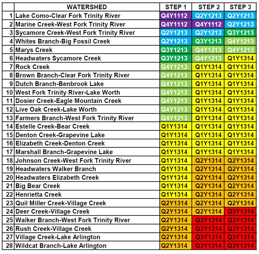
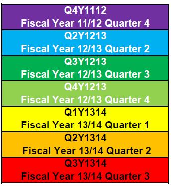
9 STEP 1: Identification Data Review and Map Generation Watershed/Outfall Counts WATERSHED OUTFALL TOTAL 1 Lake Como-Clear Fork Trinity River Marine Creek-West Fork Trinity River Sycamore Creek-West Fork Trinity River Whites Branch-Big Fossil Creek Marys Creek Headwaters Sycamore Creek Rock Creek 3 8 Brown Branch-Clear Fork Trinity River 3 9 Dutch Branch-Benbrook Lake West Fork Trinity River-Lake Worth Dosier Creek-Eagle Mountain Creek Live Oak Creek-Lake Worth Farmers Branch-West Fork Trinity River Estelle Creek-Bear Creek Denton Creek-Grapevine Lake 4 16 Elizabeth Creek-Denton Creek Marshall Branch-Grapevine Lake Johnson Creek-West Fork Trinity River Headwaters Walker Branch Headwaters Elizabeth Creek Big Bear Creek Henrietta Creek Quil Miller Creek-Village Creek Deer Creek-Village Creek Walker Branch-West Fork Trinity River Rush Creek-Village Creek Village Creek-Lake Arlington Wildcat Branch-Lake Arlington 420 TOTAL 9864
10 STEP 1: Identification Data Review and Map Generation Data Resources & Attributes MS4 Data Inlets Lines Outfalls Monitored Outfalls MS4 Attributes Diameter End of System Status Unique ID Monitoring ID Base Map Data Watersheds Hydrology Land Use

11 STEP 1: Identification Data Review and Map Generation EOS Qualifiers

12 STEP 1: Identification Data Review and Map Generation EOS Qualifiers
13 STEP 1: Identification Data Review and Map Generation EOS Identification/Map Counts WATERSHED OUTFALL TOTAL EOS TOTAL # of FIELD MAPS 1 Lake Como-Clear Fork Trinity River Marine Creek-West Fork Trinity River Sycamore Creek-West Fork Trinity River Whites Branch-Big Fossil Creek Marys Creek Headwaters Sycamore Creek Rock Creek Brown Branch-Clear Fork Trinity River Dutch Branch-Benbrook Lake West Fork Trinity River-Lake Worth Dosier Creek-Eagle Mountain Creek Live Oak Creek-Lake Worth Farmers Branch-West Fork Trinity River Estelle Creek-Bear Creek Denton Creek-Grapevine Lake Elizabeth Creek-Denton Creek Marshall Branch-Grapevine Lake Johnson Creek-West Fork Trinity River Headwaters Walker Branch Headwaters Elizabeth Creek Big Bear Creek Henrietta Creek Quil Miller Creek-Village Creek Deer Creek-Village Creek Walker Branch-West Fork Trinity River Rush Creek-Village Creek Village Creek-Lake Arlington Wildcat Branch-Lake Arlington TOTAL
14 STEP 2: Field Visit Verification Field Maps Dry Weather Field Screening: FIELD-iD Asset Entry Field Visit

15 STEP 2: Field Visit Verification Field Maps

16 STEP 2: Field Visit Verification Dry Weather Field Screening: FIELD-iD Asset Entry

17 STEP 2: Field Visit Verification Field Visit EOS Qualification - 36 inches or greater - 50 acres or more OR - industrial - 12 inches or greater - 2 acres or more

18 STEP 2: Field Visit Verification Field Visit Outfall Location - Accessibility - Location Description - Coordinates - Photo Outfall Attributes - Diameter - Unique ID - Monitoring ID DWFS Screening - Chemical - Environmental
19 STEP 3: Data Upload Dry Weather Field Screening: FIELD-iD Data Entry Dry Weather Field Screening: FIELD-iD Table Export GIS Join Table EOS & Monitoring Percentage of Outfall Totals


20 STEP 3: Data Upload Dry Weather Field Screening: FIELD-iD Data Entry

21 STEP 3: Data Upload Dry Weather Field Screening: FIELD-iD Table Export FIELD-iD GIS ID Number Monitoring ID RFID Number Unique ID


22 STEP 3: Data Upload GIS Join Table Import FIELD-iD Table Join FIELD-iD & MS4 Identify Feature Hyperlink to FIELD-iD


23 STEP 3: Data Upload EOS & Monitoring Percentage of Outfall Totals
24 Summary EOS Identification Project Schedule Dry Weather Field Screening: FIELD-iD Query Future Assets
25 Summary EOS Identification Project Schedule sfdgh


26 Summary Dry Weather Field Screening: FIELD-iD Query FIELD-iD Search Box GIS Interactive Map Hyperlink

27 Future Items - Development - Redevelopment - Inactive List Table Relate - New Features - 3-Step Process Quarterly Summary Future Assets
28 Betsi Chatham, GISP Senior GIS Analyst Questions??? City of Fort Worth Transportation & Public Works Environmental Management 1000 Throckmorton Fort Worth, Texas 76102
Look Twice! Inventorying Pavement Markings for the City of Austin. Our story of how we accomplished data inventory of our city crosswalks.
 Look Twice! Inventorying Pavement Markings for the City of Austin. Our story of how we accomplished data inventory of our city crosswalks. City of Austin Austin Transportation Department Signs & Markings
1.Mill Creek Watershed Summary Description and Land Use
 1.Mill Creek Watershed Summary Description and Land Use Table xxx: Mill Creek Watershed Overview Watershed Size 31,435 acres/49.1 sq miles/ 127.1 sq km Elevation Range 5,594 feet [4,967-10,561] Stream
MONTGOMERY COUNTY, TEXAS AND INCORPORATED AREAS VOLUME 2 OF 6
 MONTGOMERY COUNTY, TEXAS AND INCORPORATED AREAS VOLUME 2 OF 6 COMMUNITY NAME COMMUNITY NUMBER CONROE, CITY OF 480484 CUT AND SHOOT, CITY OF 481279 HOUSTON, CITY OF 480296 MAGNOLIA, CITY OF 481261 MONTGOMERY,
Hard Hat Services ph: hardhatinc.com 932 N. Wright St., Suite 160 Naperville, IL 60563
 Interstate Power and Light Company Ottumwa Generation Station CCR Surface Impoundment Annual Inspection Report 154.018.015.003 Report issued: July 03, 2017 Hard Hat Services ph: 877-630-7428 hardhatinc.com
DRAFT MEMORANDUM TO FILE
 FROM: SUBJECT: DRAFT MEMORANDUM TO FILE Unique Stream Segment Committee File [NTD02182] T:\Task 8 - Unique Designations and Regulatory Issues\Draft Committee Memo.doc Summary of Regional Water Planning
TRANSPORTATION ALTERNATIVES SET-ASIDE PROGRAM
 TRANSPORTATION ALTERNATIVES SET-ASIDE PROGRAM 2017 Call for Projects Recommendations for the North Central Texas Region Kevin Kokes Regional Transportation Council June 8, 2017 ELECTRONIC ITEM 4.1 FAST
E-3: Jurisdictional Determination Supplement Report
 Lake Ralph Hall Appendix E E-3: Jurisdictional Determination Supplement Report P.O. Drawer 305 Lewisville, TX 75067 REGIONAL WATER DISTRICT (972)219-1228 Fax(972)221-9896 June 22, 2017 Mr. Chandler Peter
Bicycle and Pedestrian Plans and Improvements
 Bicycle and Pedestrian Plans and Improvements Presented to the City Council By Randle Harwood, Planning and Development, and Richard Zavala, Parks and Community Services September 24, 2013 Purpose Review
WMS 8.4 Tutorial Hydraulics and Floodplain Modeling HY-8 Modeling Wizard Learn how to model a culvert using HY-8 and WMS
 v. 8.4 WMS 8.4 Tutorial Hydraulics and Floodplain Modeling HY-8 Modeling Wizard Learn how to model a culvert using HY-8 and WMS Objectives Define a conceptual schematic of the roadway, invert, and downstream
Deer Committee Summary and Recommendations. The Village of North Haven deer committee was formed in early 2013 to
 Deer Committee Summary and Recommendations Objective: The Village of North Haven deer committee was formed in early 2013 to address the problems created by deer in the Village of North Haven NY. The increase
Sam s Club: Round-Up Ride May 2-3, 2015
 Sam s Club: Round-Up Ride May 2-3, 2015 MS Staff Justin Martin Development Manager Bike MS Email: Justin.Martin@nmss.org Phone: 469-619-4709 Hayden Scarnato Development Coordinator Email: hayden.scarnato@nmss.org
The City of Lynnwood. Centrifuge or Screw Press? To Incinerate or not to Incinerate a Best Practice Review
 The City of Lynnwood Centrifuge or Screw Press? To Incinerate or not to Incinerate a Best Practice Review Agenda The City of Lynnwood Lynnwood Wastewater Treatment Evaluation Process O&M Cost Comparison
Executive Summary. Map 1. The Santa Clara River watershed with topography.
 Santa Clara River Steelhead Trout: Assessment and Recovery Opportunities December 2005 Prepared By: Matt Stoecker and Elise Kelley, Ph.D. University of California, Santa Barbara Prepared For: The Santa
Salmon River Cooperative Noxious Weed Program (CNWP) Presented by the Salmon River Restoration Council
 Presented by the Salmon River Restoration Council") Salmon River Cooperative Noxious Weed Program (CNWP) Presented by the Salmon River Restoration Council Some of you may be thinking So where is Salmon River? Isn t it in Idaho, Washington, or Oregon? The
Salmon River Cooperative Noxious Weed Program (CNWP) Presented by the Salmon River Restoration Council Some of you may be thinking So where is Salmon River? Isn t it in Idaho, Washington, or Oregon? The
Demographic Characteristics and Trends of Bexar County and San Antonio, TX
 Demographic Characteristics and Trends of Bexar County and San Antonio, TX Leadership San Antonio Understand Infrastructure. Prepare for Growth. May 2, 2012 San Antonio, TX Select Growing States, 2000-2010
Modeling and Mapping Metro s Rail Stations
 Washington Metropolitan Area Transit Authority Modeling and Mapping Metro s Rail Stations Minhua Wang GIS Enterprise Architect mwang@wmata.com Voliya Arakkal Sr. GIS Analyst varakkal@wmata.com Andrew Oldham
Survey Technique for Underwater Digital Photography with Integrated GPS Location Data
 Survey Technique for Underwater Digital Photography with Integrated GPS Location Data Tim Siwiec: United States Environmental Protection Agency Abstract This survey technique is an inexpensive method of
FINAL REPORT. Yonkers Creek Migration Barrier Removal Project Wonderstump Road Del Norte County. Submitted By:
 FINAL REPORT Yonkers Creek Migration Barrier Removal Project Wonderstump Road Del Norte County Submitted By: Del Norte County Community Development Department Yonkers Creek Migration Barrier Removal Project
Rail Station Fact Sheet Downtown Denton Transit Center
 Rail Station Fact Sheet Downtown Denton Transit Center Station Overview The Euline Brock Downtown Denton Transit Center is located on East Hickory Street at Railroad Street in Denton near the historic
Public Hearing Tarrant County. October 11 th, 2012
 Public Hearing Tarrant County October 11 th, 2012 Public Hearing Agenda Welcome and Project Overview Ms. Maribel P. Chavez, P.E. District Engineer Texas Department of Transportation Fort Worth District
Texas Intersection Safety Implementation Plan Workshop JUNE 2, 2016
 Texas Intersection Safety Implementation Plan Workshop JUNE 2, 2016 Why Intersection Safety? A small part of overall highway system, but Each year roughly 50% of all crashes estimated 3 million involve
Walking Routes to School Program
 Walking Routes to School Program Creating Walking Routes to School using the Network Analyst Extension John Ritsko GIS Analyst City of Henderson Public Works Engineering Purpose of Program Create a WEB-based
FOR SALE 4 ESTATE PARCELS WITH EXCELLENT VIEWS
 Average Price For 4 Lots is $241,000 Per Lot 4 Lots Priced Between $152,000 (4+ Acres) & $335,000 (5+ Acres) FALLBROOK COUNTRY CLUB PALA MESA RESORT FUTURE HOME OF PALOMAR COLLEGE LIVE OAK CREEK CIRCLE
Up Your Creek! The electronic newsletter of the Alameda Creek Alliance
 Up Your Creek! The electronic newsletter of the Alameda Creek Alliance Steelhead Make a Showing in Alameda Creek Apparently not willing to wait until all of the fish ladders are constructed in Alameda
Mr. Michael Malone CPS Energy 145 Navarro Street, Mail Drop San Antonio, Texas Project No
 October 17, 2016 Mr. Michael Malone CPS Energy 145 Navarro Street, Mail Drop 100406 San Antonio, Texas 78296 Project No. 0352436 Subject: Compilation of Construction History Calaveras Power Station San
EASTERN SHORE OF VIRGINIA PEDESTRIAN FACILITIES STUDY
 EASTERN SHORE OF VIRGINIA PEDESTRIAN FACILITIES STUDY Inventory and Needs Assessment December 2017 Mason Avenue, Cape Charles Prepared by: Accomack-Northampton Planning District Commission This Page Intentionally
Implementation of an Asset Management Software for Proactive Management and Optimization of the Collection System Rehabilitation and Renewal Program
 Implementation of an Asset Management Software for Proactive Management and Optimization of the Collection System Rehabilitation and Renewal Program P. S. Arora, P.E. Joel Nickerson 2,591,286 linear feet
Undeveloped Zoning Inventory February 2004
 Undeveloped Zoning Inventory February 2004 Prepared by Planning Department Undeveloped Zoning Inventory February 2004 Project Description: The Undeveloped Zoning Inventory (the Inventory) is a periodic
LAKE JESUP VEGETATION MAPPING: AN INTER-AGENCY COLLABORATION. Lakshmi Sankaran, GISP Public Works Department, Seminole County
 LAKE JESUP VEGETATION MAPPING: AN INTER-AGENCY COLLABORATION Lakshmi Sankaran, GISP Public Works Department, Seminole County LAKE JESUP Area - 12 sq miles Shoreline - 53 miles Watershed - 136 sq miles
Preliminary Findings for Texas s North Central Texas Council of Governments Region
 Texas Intersection Safety Implementation Plan Preliminary Findings for Texas s North Central Texas Council of Governments Region March 30, 2016 Revised June 15, 2016 Introduction The overall objective
What GCSAA has done for me. Rodney Crow, CGCS
 What GCSAA has done for me Rodney Crow, CGCS Media Outlets GCSAA Website GCM Online GCM Magazine GCSAA Phone apps Online Tools Membership Directory SDS/Labels Database Turfgrass Calculators Excel Templates
STREAM SURVEY File form No..
 scanned for KRIS THE RESOURCES AGENCY OF CALIFORNIA California Department of Fish and Game STREAM SURVEY File form No.. Date: September 4, 1969. NAME: North Fork Schooner Gulch Creek COUNTY: Mendocino.
Total Suspended Solids, Stable Flow, and Wet Weather Event Monitoring in the Bass River Watershed. December The Cadmus Group, Inc.
 Total Suspended Solids, Stable Flow, and Wet Weather Event Monitoring in the Bass River Watershed December 2004 The Cadmus Group, Inc. Grand Valley State University Annis Water Resources Institute Submitted
Total Suspended Solids, Stable Flow, and Wet Weather Event Monitoring in the Unnamed Tributary to the Grand River Watershed.
 Total Suspended Solids, Stable Flow, and Wet Weather Event Monitoring in the Unnamed Tributary to the Grand River Watershed December 2004 The Cadmus Group, Inc. Grand Valley State University Annis Water
Teton County Related Hunting and Fishing Spending, For the Wyoming Wildlife Federation. David T. Taylor & Thomas Foulke
 Teton County Related Hunting and Fishing Spending, 2015 For the Wyoming Wildlife Federation University of Wyoming, Department of Agricultural & Applied Economics David T. Taylor & Thomas Foulke 1 February
ORANGE COUNTY TRANSPORTATION AUTHORITY. Metrolink Ridership and Revenue Quarterly Report. Staff Report
 ORANGE COUNTY TRANSPORTATION AUTHORITY Metrolink Ridership and Revenue Quarterly Report Staff Report March 8, 2012 To: From: Subject: Transit Committee Will Kempton, Chief Executive Officer Metrolink Ridership
Fremont County Related Hunting and Fishing Spending, 2015
 Fremont County Related Hunting and Fishing Spending, 2015 For the Wyoming Wildlife Federation University of Wyoming, Department of Agricultural & Applied Economics David T. Taylor & Thomas Foulke September,
South Bay Coastal Ocean Observing System California Clean Beaches Initiative
 South Bay Coastal Ocean Observing System California Clean Beaches Initiative Quarterly Report March 2004 to City of Imperial Beach Eric Terrill 1 1 Scripps Institution of Oceanography, University of California,
TABLE OF CONTENTS 1.0 INTRODUCTION PLAN CERTIFICATION (B)(4) 1
(4) 1") TABLE OF CONTENTS 1.0 INTRODUCTION 1 2.0 PLAN CERTIFICATION 257.102(B)(4) 1 3.0 WRITTEN CLOSURE PLAN 2 3.1 Narrative 2 3.2 CCR Removal 2 3.3 CCR Left in Place 3 3.4 Maximum CCR Inventory 3 3.5 Maximum
TABLE OF CONTENTS 1.0 INTRODUCTION 1 2.0 PLAN CERTIFICATION 257.102(B)(4) 1 3.0 WRITTEN CLOSURE PLAN 2 3.1 Narrative 2 3.2 CCR Removal 2 3.3 CCR Left in Place 3 3.4 Maximum CCR Inventory 3 3.5 Maximum
Hard Hat Services ph: hardhatinc.com 932 N. Wright St., Suite 160 Naperville, IL 60563
 Interstate Power and Light Company Ottumwa Generation Station CCR Surface Impoundment Annual Inspection Report 154.018.012.003 Report issued: December 21, 2016 Hard Hat Services ph: 877-630-7428 hardhatinc.com
Application of IP Models for Salmon and Steelhead Recovery Planning in California
 Application of IP Models for Salmon and Steelhead Recovery Planning in California Brian Spence and David Boughton NMFS Southwest Fisheries Science Center Uses of IP models in technical recovery planning
Economic Development City of Watauga
 Economic Development City of Watauga Dear Business Owner: First, let me thank you for choosing the City of Watauga for your business location. We appreciate your investment in the community. To help your
Carbon County Related Hunting and Fishing Spending, 2015
 Carbon County Related Hunting and Fishing Spending, 2015 1 For the Wyoming Wildlife Federation University of Wyoming, Department of Agricultural & Applied Economics AAAAddd David T. Taylor & Thomas Foulke
Final Report August 2005
 2.0 REGIONAL STUDY AREA 2.1 Regional Setting 2.1.1 Topography The Los Angeles Region is located within the western portion of the Transverse Ranges Geomorphic Province. The San Andreas transform fault
East Downtown Tax Increment Reinvestment Zone (TIRZ) No. 15 Infrastructure Assessment Study
 No. 15 Infrastructure Assessment Study") East Downtown Tax Increment Reinvestment Zone (TIRZ) No. 15 Infrastructure Assessment Study Houston, TX Technical Memorandum April 15 th, 2009 Prepare by: 2950 North Loop West, Ste. 900 Houston, TX 77092
East Downtown Tax Increment Reinvestment Zone (TIRZ) No. 15 Infrastructure Assessment Study Houston, TX Technical Memorandum April 15 th, 2009 Prepare by: 2950 North Loop West, Ste. 900 Houston, TX 77092
RESPONSE TO COMMENT: 45
 45 a. 45 b. RESPONSE TO COMMENT: 45 California State Lands Commission (Stephen L. Jenkins) 45-a: The comment states that the State Lands Commission will not require a lease at this time but may require
Master Development Plan for the TxDOT North Tarrant Express Project, Segments 2-4. Chapter 3: Draft List of Facilities.
 Table of Contents 3.1. Interim vs. Ultimate Configuration for the Remaining Segments of NTE... 1 3.2. Characteristics of Project Segments... 3 3.2.1. All Segments... 5 3.2.2. Segment 2E... 8 3.2.3. Segment
D.B. Wilson Station CCR Landfill
 D.B. Wilson Station CCR Landfill Disposal of Coal Combustion Residuals (CCR) from Electric Utilities Final Rule Closure and Post-closure Care Plan October 11, 2016 Prepared By: Project ID: 160030A Big
Pre-Application Document Kaweah Project (FERC Project No. 298)
") TABLE OF CONTENTS Page 3.12 Aesthetic Resources... 3.12-1 3.12.1 Information Sources... 3.12-1 3.12.2 Setting... 3.12-1 3.12.3 Project Facilities... 3.12-2 3.12.4 Previous Visual Resources Assessment...
TABLE OF CONTENTS Page 3.12 Aesthetic Resources... 3.12-1 3.12.1 Information Sources... 3.12-1 3.12.2 Setting... 3.12-1 3.12.3 Project Facilities... 3.12-2 3.12.4 Previous Visual Resources Assessment...
2018 Challenger, CMZ, SCMZ, and Challenger 1-Day Events
 2018 Challenger, CMZ, SCMZ, and Challenger 1-Day Events JANUARY 1st Weekend (6-7) Frisco Tennis School (City of Frisco) Challenger Willow Fork County Club Challenger Brazos Valley Tennis Association CMZ
Rail Station Fact Sheet CentrePort/DFW Airport Station
 Rail Station Fact Sheet CentrePort/DFW Airport Station Station Overview CentrePort/DFW Airport Station is located by Statler Boulevard at Breezewood Drive in Fort Worth. Free shuttles connect the station
Pedestrian Improvements Kemp Blvd Wichita Falls (Midwestern Pkwy to Southwest Pkwy)
") EXHIBIT A TRANSPORTATION ALTERNATIVES PROGRAM (TAP) PROJECTS SELECTED FOR FUNDING SMALL URBAN AREAS (POPULATION 5,001 200,000) Nominating Entity TAP Project Name Federal Funds Bryan South College Phase
EXHIBIT A TRANSPORTATION ALTERNATIVES PROGRAM (TAP) PROJECTS SELECTED FOR FUNDING SMALL URBAN AREAS (POPULATION 5,001 200,000) Nominating Entity TAP Project Name Federal Funds Bryan South College Phase
GIS for Public Opinion / Survey Research. Timothy Michalowski Senior Statistical GIS Analyst Abt SRBI - New York, NY
 GIS for Public Opinion / Survey Research Timothy Michalowski Senior Statistical GIS Analyst Abt SRBI - New York, NY July 17, 2014 Agenda Introduction Public Opinion / Survey Research Application of GIS
TWO FORKS RANCH A5 REAL ESTATE. 790 Acres. Smiths Fork - Lincoln County - Wyoming
 TWO FORKS RANCH 790 Acres Smiths Fork - Lincoln County - Wyoming A5 REAL ESTATE WWW.A5REALESTATE.COM QUICK FACTS Located in the upper Smiths Fork drainage of Lincoln County, Wyoming, the Two Forks Ranch
PThe 16,000 acre Pettyjohn Ranch is located on the west side of Tehama County twenty miles from Red Bluff, CA on Interstate
 PThe 16,000 acre Pettyjohn Ranch is located on the west side of Tehama County twenty miles from Red Bluff, CA on Interstate 5. It is surrounded by privately owned land and can be reached all year by paved
Sam s Club: Round-Up Ride April 30 May 1, 2016
 Sam s Club: Round-Up Ride April 30 May 1, 2016 MS Staff Leah Weatherl VP, Bike MS Email: Leah.weatherl@nmss.org Phone: 469-619-4710 Hayden Scarnato Bike MS Development Coordinator Email: hayden.scarnato@nmss.org
NCTCOG 16-County Crash and Fatality Data
 North Central Texas Council of Governments - Traffic Safety Crash and Fatality Statistics NORTH CENTRAL TEXAS COUNCIL OF GOVERNMENTS (NCTCOG) 2012 Safety Program Performance Measures NCTCOG 16-County Crash
This is a digital document from the collections of the Wyoming Water Resources Data System (WRDS) Library.
 Library.") This is a digital document from the collections of the Wyoming Water Resources Data System (WRDS) Library. For additional information about this document and the document conversion process, please contact
This is a digital document from the collections of the Wyoming Water Resources Data System (WRDS) Library. For additional information about this document and the document conversion process, please contact
SIDEWALK ASSESSMENT PHASE TWO
 2013 SIDEWALK ASSESSMENT PHASE TWO Table of Contents Lake of the Ozarks Council of Local Governments Sidewalk Assessment Phase TWO Criteria... 1 Communities Included In Sidewalk Assessment Phase TWO...
Coastal Hazards Study
 Coastal Hazards Study 2212 Beach Boulevard, Pacifica Prepared for: EXECUTIVE SUMMARY City of Pacifica 170 Santa Maria Ave Pacifica, CA 94044 Prepared by: moffatt & nichol 2185 N. California Blvd. Walnut
CLOSURE PLAN. CCR (b) GERS Landfill Area. Welsh Power Plant Pittsburg, Texas. October, 2016
 GERS Landfill Area. Welsh Power Plant Pittsburg, Texas. October, 2016") CLOSURE PLAN CCR 257.102(b) Landfill Area Welsh Power Plant Pittsburg, Texas October, 2016 Prepared for : Southwest Electric Power Company Welsh Plant Pittsburg, Texas Prepared by: American Electric Power
CLOSURE PLAN CCR 257.102(b) Landfill Area Welsh Power Plant Pittsburg, Texas October, 2016 Prepared for : Southwest Electric Power Company Welsh Plant Pittsburg, Texas Prepared by: American Electric Power
Lake Minatare Home and Acreage
 Lake Minatare Home and Acreage An outdoorsman s paradise with excellent recreational opportunities and a cozy log home sitting on 78± acres. Email: Jon@lashleyland.com Property Highlights List Price $599,000
WHO DIRTIED THE WATER?
 WHO DIRTIED THE WATER? LONG AGO IN THE BOSTON MOUNTAINS SOURCE: littlebuffalodotcom.files.wordpress.com/2012/12/img_5000.jpg STREAMS RAN CLEAN & CLEAR SOURCE: littlebuffalodotcom.files.wordpress.com/2013/03/img_3143.jpg
1.Warm Springs Creek (Anaconda) Watershed Description and Land Use
 Watershed Description and Land Use") 1.Warm Springs (Anaconda) Watershed Description and Land Use Table xxx: Warm Springs Watershed Overview Watershed Size 92,288 acres/144.2 sq miles/373.6 sq km Elevation Range 5,781 feet [4,800-10,581]
1.Warm Springs (Anaconda) Watershed Description and Land Use Table xxx: Warm Springs Watershed Overview Watershed Size 92,288 acres/144.2 sq miles/373.6 sq km Elevation Range 5,781 feet [4,800-10,581]
DOWNLOAD OR READ : THE RIVER BELOW PDF EBOOK EPUB MOBI
 DOWNLOAD OR READ : THE RIVER BELOW PDF EBOOK EPUB MOBI Page 1 Page 2 the river below the river below pdf the river below The trail to Thunder River and Tapeats Creek winds east across the floor of Surprise
Wisconsin s Citizen-Based Monitoring Partnership Program and Trout Unlimited Driftless Area Restoration Effort (TUDARE)
") Wisconsin s 2010-11 Citizen-Based Monitoring Partnership Program and Trout Unlimited Driftless Area Restoration Effort (TUDARE) TUDARE Stream Monitoring Sites Established in 2010-2011 Summary Prepared
Wisconsin s 2010-11 Citizen-Based Monitoring Partnership Program and Trout Unlimited Driftless Area Restoration Effort (TUDARE) TUDARE Stream Monitoring Sites Established in 2010-2011 Summary Prepared
VDOT Crash Analysis Procedures for Roadway Safety Assessments
 Crash analysis is a critical component of road safety analysis. The crash analysis procedures defined in this document will help: Identify where to target resources for detailed crash analysis Assess the
Technical Report Culvert A Hydraulic Analysis
 DATE: November 3, 2011 Technical Report Culvert A Hydraulic Analysis TO: FROM: RE: Jim Reiser, P.E. Project Manager Parsons Brinckerhoff, Inc. Kurt Killian, P.E., CFM Parsons Brinckerhoff, Inc. Design
Dallas Park and Recreation Department. ICMA 2005 Survey Briefing January 8, 2007
 Dallas Park and Recreation Department ICMA 2005 Survey Briefing January 8, 2007 ICMA Center for Performance Measurement Purpose: To help local governments improve the effectiveness and efficiency of public
DOWNLOAD OR READ : TROUT STREAMS OF SOUTHERN NEW ENGLAND PDF EBOOK EPUB MOBI
 DOWNLOAD OR READ : TROUT STREAMS OF SOUTHERN NEW ENGLAND PDF EBOOK EPUB MOBI Page 1 Page 2 trout streams of southern new england trout streams of southern pdf trout streams of southern new england Trout
Alberta Conservation Association 2009/10 Project Summary Report. Project Name: Crowsnest Drainage Sport Fish Population Assessment Phase 1
 Alberta Conservation Association 2009/10 Project Summary Report Project : Crowsnest Drainage Sport Fish Population Assessment Phase 1 Fisheries Program Manager: Peter Aku Project Leader: Jason Blackburn
Sandhills Hunting Ranch
 Sandhills Hunting Ranch A legacy ranch with spectacular hunting and breathtaking views of the Nebraska Sandhills. Property Highlights List Price $8,200,000 Location Legal Description 25 miles SW of Hyannis
CTH M HIGHWAY PROJECT CTH Q to STH 113
 CTH M HIGHWAY PROJECT CTH Q to STH 113 PUBLIC INFORMATIONAL MEETING #3 Wednesday, May 25, 2005 Town of Westport Administration Building 5387 Mary Lake Road 6:00 p.m. to 8:00 p.m. PUBLIC INFORMATIONAL MEETING
SEASONS CREEK ±175.8 ACRES
 W Columbia Rd E Columbia Rd SEASONS CREE ±175.8 ACRES Applewood UNA, ADA COUNTY, IDAHO S Black Cat Rd W Hubbard Rd S Ten Mile Rd Silvertrail Denali Heights S Linder Rd Timbermist S Rd Patagonia E Hubbard
U.S. Fish and Wildlife Service Native American Crosscut Funding
 U.S. Fish and Wildlife Service Native American Crosscut Funding Tribal / Interior Budget Council National Budget Meeting L Enfant Plaza Hotel Washington, DC November 8, 2013 U.S. Fish and Wildlife Service
Pedestrian, Bicycle and Traffic Calming Strategic Implementation Plan. January 18, 2011
 Pedestrian, Bicycle and Traffic Calming Strategic Implementation Plan January 18, 2011 Tonight s Agenda Receive update on project Provide feedback on two policy issues Complete Streets Policy Project Prioritization
Buchanan Ranch 793+/- Acres Throckmorton County, Texas $1,308,450 ($1,650/acre)
") Office: (214) 361-9191 Buchanan Ranch 793+/- Acres Throckmorton County, Texas $1,308,450 ($1,650/acre) Throckmorton County, Texas 793+/- Acres PROPERTY DESCRIPTION: The 793+/- acre property has good diversity
Office: (214) 361-9191 Buchanan Ranch 793+/- Acres Throckmorton County, Texas $1,308,450 ($1,650/acre) Throckmorton County, Texas 793+/- Acres PROPERTY DESCRIPTION: The 793+/- acre property has good diversity
Outlet Structures T-12
 Description This section provides guidance and details for outlet structures for use primarily with BMPs utilizing sedimentation, (i.e., extended detention basins (EDBs), retention ponds, and constructed
CHRISTIAN BROTHERS AUTOMOTIVE
 CHRISTIAN BROTHERS AUTOMOTIVE 3673 Vandora Springs Rd., Fort Mill, SC 29715 PROPERTY HIGHLIGHTS 12 Years Left On Primary Term Of NNN Corporate CBAC Lease w/ Five (5), Ten (10) Year Tenant Renewal Options
ADOT Statewide Bicycle and Pedestrian Program Summary of Phase IV Activities APPENDIX B PEDESTRIAN DEMAND INDEX
 ADOT Statewide Bicycle and Pedestrian Program Summary of Activities APPENDIX B PEDESTRIAN DEMAND INDEX May 24, 2009 Pedestrian Demand Index for State Highway Facilities Revised: May 29, 2007 Introduction
San Antonio Creek Spreading Grounds Rehabilitation Project Ojai Valley, CA
 Ventura County Watershed Protection District San Antonio Creek Spreading Grounds Rehabilitation Project Ojai Valley, CA Presentation to Ventura River Watershed Council Project Funding Proposition 50 Integrated
Minnesota Department of Natural Resources Lanesboro Area Fisheries Office FAQ sheet
 Minnesota Department of Natural Resources Lanesboro Area Fisheries Office FAQ sheet 1) Can you fish with minnows in designated trout streams? Possessing live minnows or using them for bait on designated
December 6, Via fedex
 December 6, 2016 Via fedex U.S. Fish & Wildlife Service Pennsylvania Field Office Endangered Species Section 110 Radnor Road, Suite 101 State College, PA 16801 Re: Rover Pipeline LLC, Rover Pipeline Project
1998 Willow Creek Downstream Migrant Trap Report. Draft. Prepared By: C. A. Walker. Lower Trinity Ranger District. Six Rivers National Forest
 1998 Willow Creek Downstream Migrant Trap Report Draft Prepared By: C. A. Walker Lower Trinity Ranger District Six Rivers National Forest September 1998 Executive Summary The downstream migrant trap was
Rail Station Fact Sheet Downtown Carrollton Station
 Rail Station Fact Sheet Downtown Carrollton Station Station Overview Downtown Carrollton Station is located at East Belt Line Road and Broadway Street near the historic Downtown Carrollton Square. The
Emergent Sandbar Habitat Program Middle Missouri River
 Emergent Sandbar Habitat Program Middle Missouri River Jeremiah Szynskie, P.E. Hydrologic Engineering Branch Introduction Main Stem System Dam Closures Fort Peck 1937 Fort Randall 1952 Garrison - 1953
MEETING Agenda. Introductions. Project Overview. Key Study Components. Alternative Station Concepts. Preferred Station Concept. Next Steps.
 City GARLAND Council ROADVISION Briefing STUDY VISION STUDY Dallas, TX April 8, 2010 1 1 MEETING Agenda Introductions Project Overview Key Study Components Alternative Station Concepts Preferred Station
PUBLIC ASSISTANCE MAP BOOK
 PUBLIC ASSISTANCE MAP BOOK 10/19/2018 00 Geospatial Information Unit (GIU) Page Map Title Map Owner 2 PA Categories A & B by County GIU 3 PA Categories C - G by County GIU 4 PA Project Completion by County
Osceola County Property Appraiser GIS Modernization: An Enterprise Implementation
 Osceola County Property Appraiser GIS Modernization: An Enterprise Implementation Osceola County Osceola County Where We Were: History of Osceola Co PA Parcel Mapping Vision For The Future Project Goals
Importance of un-named tributary streams to Brook Trout populations. Dr. Jonathan M. Niles Dr. Dan Ressler
 Importance of un-named tributary streams to Brook Trout populations. Dr. Jonathan M. Niles Dr. Dan Ressler Pennsylvania Streams All streams of PA have a designated use - Huge resource - 8,011 named tributaries:
VILLAGE OF HINSDALE MINUTES PARK AND RECREATION COMMISSION Monday, July 23, 6:30 PM Memorial Hall Board Room
 VILLAGE OF HINSDALE MINUTES PARK AND RECREATION COMMISSION Monday, July 23, 2012 @ 6:30 PM Memorial Hall Board Room Chairman Kluchenek called the meeting of the Park and Recreation Commission to order
The Effects of Stream Adjacent Logging on Downstream Populations of Coastal Cutthroat Trout
 The Effects of Stream Adjacent Logging on Downstream Populations of Coastal Cutthroat Trout. D. S. Bateman 1, R.E. Gresswell 2, Aaron M. Berger 3, D.P. Hockman-Wert 4 and D.W. Leer 1 1 Department of Forest
CHRISTIAN BROTHERS AUTOMOTIVE
 CHRISTIAN BROTHERS AUTOMOTIVE, PROPERTY HIGHLIGHTS 12 Years Left On Primary Term Of NNN Corporate CBAC Lease w/ Five (5), Ten (10) Year Tenant Renewal Options 1.5% Annual Rent Escalations Starting in Year
Project Period 1/15/ /31/2017 Project Location Description (from Proposal) Project Summary (from Proposal) Summary of Accomplishments
 Project Summary (from Proposal) Summary of Accomplishments") Easygrants ID: 28897 National Fish and Wildlife Foundation NFWF Project ID: 0103.12.028897 Wildlife Keystone - Sky Island Grasslands - Fall 2011 - Submit Interim Programatic Report - Basic Grantee Organization:
Easygrants ID: 28897 National Fish and Wildlife Foundation NFWF Project ID: 0103.12.028897 Wildlife Keystone - Sky Island Grasslands - Fall 2011 - Submit Interim Programatic Report - Basic Grantee Organization:
SIDEWALK INSPECTION & MANAGEMENT SYSTEM Conclusions & Recommendations Report
 SIDEWALK INSPECTION & MANAGEMENT SYSTEM Conclusions & Recommendations Report City of Ft. Lauderdale, Florida July 1, 2014 City Project No. 11762A TABLE OF CONTENTS EXECUTIVE SUMMARY... i 1.0 INTRODUCTION
Confederated Tribes of the Umatilla Indian Reservation -- Cayuse, Umatilla, and Walla Walla Tribes
 2018-2019 Treaty Hunting Seasons and Regulations Confederated Tribes of the Umatilla Indian Reservation -- Cayuse, Umatilla, and Walla Walla Tribes CTUIR Tribal Hunting Rights Reserved in 1855 Treaty a
Alberta Conservation Association 2018/19 Project Summary Report. Project Name: North Saskatchewan River Drainage Fish Sustainability Index Data Gaps
 Alberta Conservation Association 2018/19 Project Summary Report Project Name: North Saskatchewan River Drainage Fish Sustainability Index Data Gaps Fisheries Program Manager: Peter Aku Project Leader:
DOWNLOAD OR READ : THE TROUT FISHERMEN PDF EBOOK EPUB MOBI
 DOWNLOAD OR READ : THE TROUT FISHERMEN PDF EBOOK EPUB MOBI Page 1 Page 2 the trout fishermen the trout fishermen pdf the trout fishermen Trout is the common name for a number of species of freshwater fish
Creek Trash Assessment (CTA) Methodology (Demonstration: Mill Run Creek, Cheltenham, Pa.)
 Methodology (Demonstration: Mill Run Creek, Cheltenham, Pa.)") Creek Trash Assessment (CTA) Methodology (Demonstration: Mill Run Creek, Cheltenham, Pa.) Mill Run Creek emerges from a storm sewer in Philadelphia to an open creek in Cheltenham. The Creek downstream
Creek Trash Assessment (CTA) Methodology (Demonstration: Mill Run Creek, Cheltenham, Pa.) Mill Run Creek emerges from a storm sewer in Philadelphia to an open creek in Cheltenham. The Creek downstream
Minimum Standards for Driveway Construction Village of Bear Creek
 Minimum Standards for Driveway Construction Village of Bear Creek An exception to the following requirements may only be granted by city council. The needs of each drainage system are considered independently,