GIS for Public Opinion / Survey Research. Timothy Michalowski Senior Statistical GIS Analyst Abt SRBI - New York, NY
|
|
|
- Tamsyn Paul
- 5 years ago
- Views:
Transcription


1 GIS for Public Opinion / Survey Research Timothy Michalowski Senior Statistical GIS Analyst Abt SRBI - New York, NY July 17, 2014
2 Agenda Introduction Public Opinion / Survey Research Application of GIS for Survey Research: START of projects (proposals, sample plans, demographic targets) MAIN STUDY efforts (data collection, geocoding, reporting) END of projects (quality checks, analysis, visualization, deliverables) Questions Abt SRBI pg 2
3 Introduction: Abt SRBI Timothy Michalowski, Senior Statistical GIS Analyst GIS Manager at Abt SRBI, started GIS department 12+ years GIS experience, focus on GIS for Social Research Previously worked at NYC DOT, Puget Sound Regional Council Master of Urban Planning, University of Illinois at Chicago (2002) Abt SRBI National Leading survey research firm, founded in th largest Research firm in USA (Honomichl List) Headquarters in NYC, with offices in DC, Chicago, Boston, Arizona, North Carolina, Florida, & Ohiio Expertise in 16 practice groups, including Transportation, Social Policy, Market Research, Health, Energy, Elections, GIS, etc. Abt SRBI pg 3
4 Introduction: Abt SRBI GIS Geographic Information Systems (GIS) Dept. - Formed in 2010 Provides GIS support to all Abt SRBI practice groups: Social Policy, Health, Housing, Transportation, Environmental, etc. Clients utilizing Abt SRBI GIS in studies have included: HUD, NOAA, EPA, NYC Economic Development Corporation (NYCEDC), Port Authority of NY & NJ, Southern California Association of Governments (SCAG), Delaware Valley Regional Planning Commission (DVRPC), American National Election Studies (ANES), USAID. Projects / Capacities include: Spatial analysis, Interactive map design, Geographic based statistics, Data visualization, GPS / mobile data collection, and GIS programming / models. We do GIS and everything GIS every day: Demonstrating the value of GIS for survey research industry Abt SRBI pg 4
5 GIS for Survey Research Projects Start Main Study End Proposals Sample Plans Demographics Survey Targets Data Collection Geocoding Field Surveys Reporting Quality Checks Analysis Visualization Deliverables Simple uses of GIS Complex uses of GIS Abt SRBI pg 5

6 GIS for Survey Research Projects Start NEW RFP! Proposals Sample Plans Demographics Survey Targets Abt SRBI pg 6

7 Study Area Boundaries Neighborhood Albany Park Andersonville Archer Heights Armour Square Ashburn Ashburn Estates Auburn Gresham Avalon Park Avondale Belmont Central Belmont Gardens Belmont Heights Belmont Terrace Beverly Beverly View Beverly Woods Study Area Boundaries? Abt SRBI pg 7

8 Study Area Boundaries Study Area Boundaries? Zip Code Market Areas? Abt SRBI pg 8


9 Target Areas Study Area by Zip Codes Abt SRBI pg 9

10 Target Areas Oversampling of Transit Propensity Areas Census Tracts Abt SRBI pg 10

11 Target Areas Customized Target Areas Abt SRBI pg 11

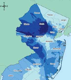
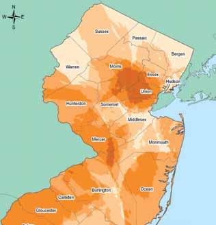
12 Demographics of Study Areas Abt SRBI pg 12

13 Demographics of Study Areas Abt SRBI pg 13


14 Maps in Proposals! Sample plan maps in a proposal helps convey an understanding of study complexities Abt SRBI pg 14

15 Maps in Proposals! Abt SRBI pg 15

16 Maps in Proposals! Abt SRBI pg 16


17 GIS for Survey Research Projects Main Study Data Collection Geocoding Field Surveys Reporting Abt SRBI pg 17
18 GIS for Survey Research Projects Survey Research always contain a where. Data does not exist in a vacuum. Respondent Home Location (Street, Zip Code, City, State, County) Respondent Locations (Work, School, Shopping, Recreation) Location of a Study Entity: (Powerplant, Coastline, Bank, Commercial Location, etc) Perceived Locations: (Where is?) There exists a geographic element to every study available for potential analysis. Abt SRBI pg 18

19 Geocoding Survey Data Abt SRBI pg 19

20 Geocoding Survey Data Respondent locations within 20 miles of X Abt SRBI pg 20

21 Geocoding Survey Data Abt SRBI pg 21
22 Geographic Based Screening Geoscreening Application of GIS tools for surveys Screening for participation based on geography Used by in real-time by phone interviewers or selfadministered web surveys Instantaneous designation as inside or outside study areas from address input Customizable for individual project needs Abt SRBI pg 22


23 Geoscreening Overview Any customized geography / study area Screen in/out participants in real time based on location Abt SRBI pg 23


24 Geoscreening Overview Proximity to Public Transit Tornado Paths Market research areas Distance from wildfire Life does not follow Census Tracts / Zip Codes! Abt SRBI pg 24
25 GeoScreening: NYC Youth Survey 37 NYC target neighborhoods Males 18 to 26 years old, hard to reach population in ~8% of NYC households. Almost entirely a cell phone based population How to quickly screen participants at the start of interview for eligibility in / out of the 37 NYC study areas? Results achieved = 96% provided address within ¼ mile from a study area neighborhood. Abt SRBI pg 25

26 Case Study: NYC Youth Survey Abt SRBI pg 26


27 Geoscreening Overview Screened IN! Instant real-time results Screened OUT! 1 second ESRI ArcGIS Server Abt SRBI pg 27

28 GPS Travel Surveys Lightweight: 2.5 oz Records every 1 second of travel activity Passive device Powers on automatically with movement Carried everywhere Power Button Abt SRBI pg 28


29 GPS Travel Surveys 150,000,000+ GPS Points 70,000+ Trips Abt SRBI pg 29


30 GPS Travel Surveys Add fields to a processing table Iteration through raw GPS files Import to geodatabase used Python scripts for processing finding trip starts and ends Output: cleaned featur class of GPS trips per participant Abt SRBI pg 30

31 GPS Travel Surveys 3 days of GPS data collection ~500 Households ~2 million GPS data points collected ~10,000 Trips Abt SRBI pg 31

32 GPS Travel Surveys Abt SRBI pg 32


33 Field Surveys Real-time live web based GIS services used by survey interviewers in the field Abt SRBI pg 33

34 Field Surveys Abt SRBI pg 34

35 GIS for Survey Research Projects End Quality Checks Analysis Visualization Deliverables Abt SRBI pg 35

36 Quality Checks: Address Based Sample Increase in cell phone only households requires Address Based Sample (ABS) vs. traditional landline approach GIS allows for customized survey target plans w/abs Addresses directly in Tornado Paths Abt SRBI pg 36

37 Spatial Statistical Analysis Survey of households with fishing licenses in Southern California % response rate for completed surveys Q: Is there a geographic pattern to response rate? Q: Does the response rate vary by distance from coastline? Abt SRBI pg 37

38 Spatial Statistical Analysis Directional Distribution Mapping distributional trend Elliptical polygons centered on the mean centers: Households with completed surveys vs. non-response Abt SRBI pg 38
 of foreclosures? Anselin Local Moran s I for all foreclosure locations to find points with P<.")
39 Spatial Statistical Analysis A survey for homeowners in neighborhoods with highest foreclosure rates. National dataset of foreclosures - Where to conduct interviews? Q: Where are significant neighborhoods ( clusters ) of foreclosures? Anselin Local Moran s I for all foreclosure locations to find points with P<.05 and highest Z scores selected as central points for sampling neighborhood interviews. Abt SRBI pg 39


40 Spatial Statistical Analysis Anselin Global Moran s I used for all foreclosure locations to verify that the entire dataset has a Z score of clustering and P value of significance. Getis Ord to examine concentrations of hot spots and cold spots. Abt SRBI pg 40


41 Spatial Statistical Analysis Data points (foreclosure locations) with P<.05 and highest Z scores selected as central points for sampling neighborhood interviews. Abt SRBI pg 41
42 GIS Visualization Abt SRBI pg 42

43 Web Mapping API & ArcGIS Server Abt SRBI pg 43


44 Questions? Abt SRBI pg 44

45 Thank you! Timothy Michalowski Abt SRBI 275 Seventh Ave, Suite 2700 New York, NY 10001
DRAFT 5/31/2016. The Value of Self-Reported Frequently Visited Addresses in GPS Assisted Travel Surveys Timothy Michalowski Dara Seidl
 DRAFT 5/31/2016 The Value of Self-Reported Frequently Visited Addresses in GPS Assisted Travel Surveys Timothy Michalowski Dara Seidl June 28, 2016 Agenda Travel Surveys Location Data Collection Methods
Walking Routes to School Program
 Walking Routes to School Program Creating Walking Routes to School using the Network Analyst Extension John Ritsko GIS Analyst City of Henderson Public Works Engineering Purpose of Program Create a WEB-based
March 6, 2013 Tony Giarrusso, Rama Sivakumar Center for GIS, Georgia Institute of Technology
 March 6, 2013 Tony Giarrusso, Rama Sivakumar Center for GIS, Georgia Institute of Technology 33 46 35.74 N, 83 23 48.33 W Location: Georgia Institute of Technology, College of Architecture Established:1996
Pedestrian Activity Criteria. PSAC March 8, 2011
 Pedestrian Activity Criteria PSAC March 8, 2011 Contents 1. Project Overview a) Revised schedule of PSAC hearings 2. Pedestrian Activity: Where walking is important a) Existing conditions (revisions based
METROPOLITAN TRANSPORTATION PLAN OUTREACH: INTERACTIVE MAP SUMMARY REPORT- 10/03/14
 METROPOLITAN TRANSPORTATION PLAN OUTREACH: INTERACTIVE MAP SUMMARY REPORT- 10/03/14 INTRODUCTION This document summarizes the results of the online interactive mapping exercise implemented by MIG for the
Analyzing Spatial Patterns, Statistics Based on FAST Act Safety Performance Measures
 Analyzing Spatial Patterns, Statistics Based on FAST Act Safety Performance Measures Abhishek Bhargava, PhD April 13, 2017 Agenda Objective Highway Safety Improvement Program (HSIP) & FAST Act Performance
Joint Plan for Orderly Annexation of Gainesville s Urban Reserve Area
 Legislative File #: 080404 ORDERLY ANNEXATION TEAM Joint Plan for Orderly Annexation of Gainesville s Urban Reserve Area September 29 th, 2008 ORDERLY ANNEXATION TEAM Presentation Overview I. Background
Wildlife Ad Awareness & Attitudes Survey 2015
 Wildlife Ad Awareness & Attitudes Survey 2015 Contents Executive Summary 3 Key Findings: 2015 Survey 8 Comparison between 2014 and 2015 Findings 27 Methodology Appendix 41 2 Executive Summary and Key Observations
STRAVA - DATA ACCESS AND USES. March 9, 2016 Shaun Davis + Dewayne Carver Florida Dept. of Transportation
 STRAVA - DATA ACCESS AND USES March 9, 2016 Shaun Davis + Dewayne Carver Florida Dept. of Transportation AGENDA Training Accessing the Data Data Characteristics Potential Uses Question and Answer WHAT
Student Population Projections By Residence. School Year 2016/2017 Report Projections 2017/ /27. Prepared by:
 Student Population Projections By Residence School Year 2016/2017 Report Projections 2017/18 2026/27 Prepared by: Revised October 31, 2016 Los Gatos Union School District TABLE OF CONTENTS Introduction
Temporal and Spatial Variation in Non-motorized Traffic in Minneapolis: Some Preliminary Analyses
 Temporal and Spatial Variation in Non-motorized Traffic in Minneapolis: Some Preliminary Analyses Spencer Agnew, Jason Borah, Steve Hankey, Kristopher Hoff, Brad Utecht, Zhiyi Xu, Greg Lindsey Thanks to:
Bike Share Social Equity and Inclusion Target Neighborhoods
 Bike Share Social Equity and Inclusion Target Neighborhoods Target Neighborhoods West End/Visitation Park/Academy/Hamilton Heights Wellsgoodfellow/Kingsway West The Ville/Greater Ville Kingsway East/Fountain
THE FUTURE OF SALES TAX REVENUE
 THE FUTURE OF SALES TAX REVENUE Presented by Adam Fulton, Senior Economic Associate The Outlook for Sales Taxes State governments rely on state sales taxes for more than a fifth of their revenue Economic
SCAG EMERGING REGIONAL ISSUES: GOMONROVIA OVERVIEW. City of Monrovia
 SCAG EMERGING REGIONAL ISSUES: GOMONROVIA OVERVIEW City of Monrovia WHY ARE WE TALKING ABOUT MOBILITY? BECAUSE DEMOGRAPHIC TRENDS AND HOUSING POLICY HAVE CREATED A CRISIS SITUATION. Demographic trends
NC Demographic Trends Through 2035
 NC Demographic Trends Through 2035 House Select Committee on Strategic Transportation Planning and Long Term Funding Solutions February 22, 2016 Rebecca Tippett, University of North Carolina July 1 Population
Introduction to Sugar Access. Sugar Access - Measuring Accessibility (Robert Kohler, Citilabs) Slide 1 of 21
 Slide 1 of 21") Introduction to Sugar Access Sugar Access - Measuring Accessibility (Robert Kohler, Citilabs) Slide 1 of 21 Walkability, Livability, Accessibility http://www.citilabs.com/sugaraccess Sugar Access - Measuring
Introduction to Sugar Access Sugar Access - Measuring Accessibility (Robert Kohler, Citilabs) Slide 1 of 21 Walkability, Livability, Accessibility http://www.citilabs.com/sugaraccess Sugar Access - Measuring
Roadway Bicycle Compatibility, Livability, and Environmental Justice Performance Measures
 Roadway Bicycle Compatibility, Livability, and Environmental Justice Performance Measures Conference on Performance Measures for Transportation and Livable Communities September 7-8, 2011, Austin, Texas
Osceola County Property Appraiser GIS Modernization: An Enterprise Implementation
 Osceola County Property Appraiser GIS Modernization: An Enterprise Implementation Osceola County Osceola County Where We Were: History of Osceola Co PA Parcel Mapping Vision For The Future Project Goals
Web Based Bicycle Trip Planning for Broward County, Florida
 Web Based Bicycle Trip Planning for Broward County, Florida Hartwig H. HOCHMAIR University of Florida 3205 College Avenue Fort Lauderdale, FL 33314, USA hhhochmair@ufl.edu Jennifer FU Florida International
COOPERATIVE EXTENSION Bringing the University to You
 COOPERATIVE EXTENSION Bringing the University to You Special Publication - 06-16 ECONOMIC IMPACT OF TOURISM ON COLORADO RIVER COMMUNITIES INCLUDING: LAUGHLIN BULLHEAD CITY FORT MOHAVE MOHAVE VALLEY GOLDEN
EFFECTS OF EXTENDING AND EXPANDING ENERGY-EFFICIENCY TAX DEDUCTION FOR COMMERCIAL BUILDINGS
 EFFECTS OF EXTENDING AND EXPANDING ENERGY-EFFICIENCY TAX DEDUCTION FOR COMMERCIAL BUILDINGS Prepared by Regional Economic Models, Inc. (REMI) Agenda Overview of 179D tax provision Energy efficiency and
Analyzing Gainesville s Bicycle Infrastructure
 Mateo Van Thienen 1 DCP 2002: Intro to GIS II Final Project Paper Abstract: Analyzing Gainesville s Bicycle Infrastructure The main purpose of this project is to determine which areas within Gainesville
Fishery Dependent Data Collection Office of Science and Technology
 Fishery Dependent Data Collection Office of Science and Technology MREP Southeast St. Petersburg, Florida April 22, 2014 Gordon Colvin Summary Overview of Fishery-Dependent Sampling Methods: four basic
SoundCast Design Intro
 SoundCast Design Intro Basic Design SoundCast and Daysim 3 Land use attributes Households & Individuals SoundCast DaySim Travel demand simulator Trips and Households, Excel Summary Sheets, EMME network
Biogeographic Assessment of Florida Keys National Marine Sanctuary
 Biogeographic Assessment of Florida Keys National Marine Sanctuary NOAA National Centers for Coastal Ocean Science NOAA Florida Keys National Marine Sanctuary Florida Fish and Wildlife Commission Photos
Understanding Transit Demand. E. Beimborn, University of Wisconsin-Milwaukee
 Understanding Transit Demand E. Beimborn, University of Wisconsin-Milwaukee 1 Purpose To provide a basic understanding of transit ridership and some common misunderstandings. To explain concepts of choice
Flyaway Bus: GIS Analysis on Current and Potential Ridership, Revenue, and Prospective Stations
 ProfessorBarry Waite & Bonnie Shrewsbury Flyaway Bus: GIS Analysis on Current and Potential Ridership, Revenue, and Prospective Stations 1. Abstract The Flyaway Bus is a long distance non-stop shuttle
ADOT Statewide Bicycle and Pedestrian Program Summary of Phase IV Activities APPENDIX B PEDESTRIAN DEMAND INDEX
 ADOT Statewide Bicycle and Pedestrian Program Summary of Activities APPENDIX B PEDESTRIAN DEMAND INDEX May 24, 2009 Pedestrian Demand Index for State Highway Facilities Revised: May 29, 2007 Introduction
Presentation Summary Why Use GIS for Ped Planning? What Tools are Most Useful? How Can They be Applied? Pedestrian GIS Tools What are they good for?
 1 2 Pedestrian GIS Tools What are they good for? Pro Walk / Pro Bike 2006 Presentation Summary Why Use GIS for Ped Planning? What Tools are Most Useful? How Can They be Applied? Matt Haynes Fehr & Peers
GIS Based Non-Motorized Transportation Planning APA Ohio Statewide Planning Conference. GIS Assisted Non-Motorized Transportation Planning
 The Purpose of GIS Assisted Network GIS Assisted Non-Motorized Transportation 2011 APA Ohio Statewide Conference Friday, 10:45 AM to Noon Focus on near-term projects wwwgreenwaycollabcom The purpose of
Public Bikesharing in North America: Early Operator and User Understanding
 Public in North America: Early Operator and User Understanding Elliot Martin, Ph.D. Assistant Research Engineer Susan Shaheen, Ph.D., Associate Adjunct Professor Bicycle Urbanism Symposium Washington University
BICYCLE FACILITIES INVENTORY: SUMMARY REPORT
 BICYCLE FACILITIES INVENTORY: SUMMARY REPORT Southern New Jersey September 2008 2002 D Lincoln Drive West Marlton, NJ 08053 (856) 596-8228 www.driveless.com BICYCLE FACILITIES INVENTORY SUMMARY REPORT
RESEARCH Massachusetts Recreational Boater Survey. Project Summary
 Coastal and Marine Spatial Planning RESEARCH Project Summary 2010 Massachusetts Recreational Boater Survey The 2010 Massachusetts Recreational Boater Survey gathered spatial and economic data relating
Transportation and Health Tool
 Working together to evolve the Transportation and Health Tool APHA Webinar March 22, 2016 Ann Steedly, PE Overview THT Development Context Development of Indicators Strategies, Interventions & Policies
Bike BR. A Tool for Baton Rouge, Louisiana by the City-Parish Planning Commission
 A Tool for Baton Rouge, Louisiana by the City-Parish Planning Commission APT 206 Function Code: S207 Title: Community Bikeability Tool APA s 2012 National Planning Conference April 15, 2012 Presented by:
TxDOT Bicycle Tourism Trails Study Update. April 2017 BAC Meeting April 10, 2017
 AGENDA ITEM 6 TxDOT Bicycle Tourism Trails Study Update April 2017 BAC Meeting April 10, 2017 Agenda Approval of interim products o Present study vision statement, goals, and study objectives o Present
The Role of MPOs in Advancing Safe Routes to School through the Transportation Alternatives Program
 The Role of MPOs in Advancing Safe Routes to School through the Transportation Alternatives Program In 2012, Congress made changes to Federal funding for Safe Routes to School that gave some metropolitan
NC Demographic Trends Through 2035
 NC Demographic Trends Through 2035 Joint Appropriation Committee on Transportation February 21, 2017 Rebecca Tippett, PhD Director, Carolina Demography July 1 Population (Millions) North Carolina s Total
Susitna-Watana Hydroelectric Project Document ARLIS Uniform Cover Page
 Alaska Resources Library & Information Services Document ARLIS Uniform Cover Page Title: Wildlife harvest analysis study, Study plan Section 10.20 : Final study plan SuWa 200 Author(s) Personal: Author(s)
Walking up Scenic Hills: Towards a GIS Based Typology of Crowd Sourced Walking Routes
 Walking up Scenic Hills: Towards a GIS Based Typology of Crowd Sourced Walking Routes Liam Bratley 1, Alex D. Singleton 2, Chris Brunsdon 3 1 Department of Geography and Planning, School of Environmental
NACTO Designing Cities 2014 Dongho Chang, City Traffic Engineer October 23, 2014
 NACTO Designing Cities 2014 Dongho Chang, City Traffic Engineer October 23, 2014 Presentation overview Perspective on Safety Changing needs of our cities How Seattle is meeting those needs Challenge for
Traffic Safety Barriers to Walking and Bicycling Analysis of CA Add-On Responses to the 2009 NHTS
 Traffic Safety Barriers to Walking and Bicycling Analysis of CA Add-On Responses to the 2009 NHTS NHTS Users Conference June 2011 Robert Schneider, Swati Pande, & John Bigham, University of California
Improving the Accuracy and Reliability of ACS Estimates for Non-Standard Geographies Used in Local Decision Making
 Improving the Accuracy and Reliability of ACS Estimates for Non-Standard Geographies Used in Local Decision Making Warren Brown, Joe Francis, Xiaoling Li, and Jonnell Robinson Cornell University Outline
I-20 East Transit Initiative. Stakeholder Advisory Committee Meeting September 9, :00-6:00 PM
 I-20 East Transit Initiative Stakeholder Advisory Committee Meeting September 9, 2010 4:00-6:00 PM Meeting Agenda Introductions Project Background Study Overview Role of the SAC Initial Study Findings
TRCP National Sportsmen s Survey Online/phone survey of 1,000 hunters and anglers throughout the United States
 #17144 TRCP National Sportsmen s Survey Online/phone survey of 1,000 hunters and anglers throughout the United States Methodology Public Opinion Strategies conducted a national survey of N =1,000 voters
Travel and Rider Characteristics for Metrobus
 Travel and Rider Characteristics for Metrobus 040829040.15 Travel and Rider Characteristics for Metrobus: 2012-2015 Overview The Miami Dade County Metropolitan Planning Organization (MPO) conducted a series
Westside Transportation Access Needs Assessment - Short and Long Term Improvements
 ABSTRACT The Los Angeles County Metropolitan Transportation Authority (MTA) adopted the 2001 Long Range Transportation Plan (LRTP), which sets out the County s transportation investments for the next 20-25
WYDOT Customer Satisfaction Survey 2016
 February 16 th, 2017 WYDOT Customer Satisfaction Survey 2016 Presenting results of the WYDOT Customer Satisfaction Survey, 2016 Presented By Brian Harnisch Senior Research Scientist Wyoming Survey & Analysis
2011 National Survey of Fishing, Hunting, and Wildlife-Associated Recreation
 U.S. Fish & Wildlife Service 2011 National Survey of Fishing, Hunting, and Wildlife-Associated Recreation State Overview Issued September 2012 Preliminary Estimates 2 2011 National Survey of Fishing, Hunting,
The North Shore Transportation Improvement Strategy and Western Richmond Terrace 1 : The Forgotten Corridor
 Elm Park Civic Association Island Voice Do Me A Faber The North Shore Transportation Improvement Strategy and Western Richmond Terrace 1 : The Forgotten Corridor Introduction Richmond Terrace is the northernmost
Demographic Change in North Carolina
 Demographic Change in North Carolina 5 Trends to Watch North Carolina Aggregates Association June 29, 2017 Rebecca Tippett, PhD Director, Carolina Demography July 1 Population (Millions) North Carolina
RECOMMENDED CITATION: Pew Research Center, February 2014, Public Skeptical of Decision to Hold Olympic Games in Russia
 NUMBERS, FACTS AND TRENDS SHAPING THE WORLD FOR RELEASE FEBRUARY 4, 2014 FOR FURTHER INFORMATION ON THIS REPORT: Carroll Doherty, Director of Political Research Seth Motel, Research Assistant 202.419.4372
Relationship Between Child Pedestrian Accidents and City Planning in Zarqa, Jordan
 112 TRANSPORTATION RESEARCH RECORD 1281 Relationship Between Child Pedestrian Accidents and City Planning in Zarqa, Jordan ADU H. AL-BALBISSI, MOHAMED T. ABOUL-ELA, AND SABAH SAMMOUR The relationship between
Target Shooting by Hunters and Their Use of Shooting Ranges: 1975, 1991, and 2011
 U.S. Fish & Wildlife Service Target Shooting by Hunters and Their Use of Shooting Ranges: 1975, 1991, and 2011 Addendum to the 2011 National Survey of Fishing, Hunting, and Wildlife-Associated Recreation
Spider Maps: A Summary of Best Practices and Guide to Design
 0 Spider Maps: A Summary of Best Practices and Guide to Design Wenwen Zhang Georgia Institute of Technology: School of City and Regional Planning 0 Ferst Drive Atlanta, GA 0 0--0 Wzhang00@gatech.edu Margaret
GIS Based Data Collection / Network Planning On a City Scale. Healthy Communities Active Transportation Workshop, Cleveland, Ohio May 10, 2011
 The Purpose of GIS Based Network Planning GIS Based Data Collection / Network Planning Healthy Communities Active Transportation Conference Tuesday, May 10, 2011 10:00 AM Norman Cox, LLA, ASLA. Ann Arbor,
Angler Spending on Fishing-related Durable Goods: Results from the 2014 Marine Recreational Fishing Expenditure Survey
 Angler Spending on Fishing-related Durable Goods: Results from the 2014 Marine Recreational Fishing Expenditure Survey Sabrina Lovell1, James Hilger2, and Scott Steinback3 NAAFE 2015 Ketchikan, AK 1US
Expansion of Bike Share within San Jose supports the City's ambitious mode shift goals to have 15% of commute trips completed by bicycles by 2040.
 COUNCIL AGENDA: 12/01/15 ITEM: 4 CITY OF SAN JOSE CAPITAL OF SILICON VALLEY TO: HONORABLE MAYOR AND CITY COUNCIL SUBJECT: BAY AREA BIKE SHARE EXPANSION Memorandum FROM: Jim Ortbal DATE: Approved Date irftt/ls'
Last Known Address: Processing and Applications. Ryan Kling, Ari Lewenstein, Gerry Gaes, Mandy Wong, Walter Campbell
 Last Known Address: Processing and Applications Ryan Kling, Ari Lewenstein, Gerry Gaes, Mandy Wong, Walter Campbell NCRP Annual Meeting 2017 Introduction In 2015 the NCRP requested last known address prior
How Policy Drives Mode Choice in Children s Transportation to School
 How Policy Drives Mode Choice in Children s Transportation to School Physical Activity through Active Transportation Ruth L. Steiner 2011 Technical Conference and Exhibit Lake Buena Vista, FL April 3-6,
MARKET AND CAPACITY UPDATE. Matthew Marsh September 2016
 MARKET AND CAPACITY UPDATE Matthew Marsh September 2016 1980 1981 1982 1983 1984 1985 1986 1987 1988 1989 1990 1991 1992 1993 1994 1995 1996 1997 1998 1999 2000 2001 2002 2003 2004 2005 2006 2007 2008
VGI for mapping change in bike ridership
 VGI for mapping change in bike ridership D. Boss 1, T.A. Nelson* 2 and M. Winters 3 1 Unviersity of Victoria, Victoria, Canada 2 Arizona State University, Arizona, USA 3 Simon Frasier University, Vancouver,
Growth Trends in Hampton Roads
 Presentation to the Isle of Wight County Board of Supervisors Growth Trends in Hampton Roads Hampton Roads Planning District Commission Greg Grootendorst Chief Economist September 19, 2014 Looking to 2040
Midtown Corridor Alternatives Analysis
 Midtown Corridor Alternatives Analysis Ridership Forecast Methodology and Results December 2013 Prepared by the SRF Consulting Group Team for Table of Contents Introduction... 1 Methodology... 1 Assumptions...
Estimation of damages caused by storm tides in the city of Hamburg K.-H. Pöschke DHI-WASY GmbH Waltersdorfer Str. 105, Berlin, Germany
 Estimation of damages caused by storm tides in the city of Hamburg K.-H. Pöschke DHI-WASY GmbH Waltersdorfer Str. 105, 12526 Berlin, Germany 1 Introduction The city of Hamburg is potentially endangered
Bike Planner Overview
 Bike Planner Overview A Web-based Sketch Planning Tool for Los Angeles County presented by William E. Walter, GISP April 12, 2017 GIS-T Transportation leadership you can trust. Bike Planner Overview Guiding
America s Brightest ORANGE
 America s Brightest ORANGE Oklahoma State University 2013 Survey of Alumni of Graduate Programs Jeremy Penn, Ph.D. Director Mark Nicholas, Ph.D. Assistant Director John Hathcoat, Ph.D. Statistical Analyst
Highly Migratory Species Essential Fish Habitat (EFH) Overlay February 27, 2015
 Overlay February 27, 2015") Highly Migratory Species Essential Fish Habitat (EFH) Overlay February 27, 2015 Prepared for: Northeast Regional Ocean Council (NROC) Northeast Ocean Data www.northeastoceandata.org Prepared by: Rachel
Highly Migratory Species Essential Fish Habitat (EFH) Overlay February 27, 2015 Prepared for: Northeast Regional Ocean Council (NROC) Northeast Ocean Data www.northeastoceandata.org Prepared by: Rachel
Look Twice! Inventorying Pavement Markings for the City of Austin. Our story of how we accomplished data inventory of our city crosswalks.
 Look Twice! Inventorying Pavement Markings for the City of Austin. Our story of how we accomplished data inventory of our city crosswalks. City of Austin Austin Transportation Department Signs & Markings
DAYTONA BEACH US1 - OFFICE +10,000 SF
 DAYTONA BEACH US1 - OFFICE +10,000 SF 702 S RIDGEWOOD AVE DAYTONA BEACH, FL 32114 Carl W. Lentz IV, MBA, CCIM Managing Director 386.310.7900 x103 carl.lentz@svn.com SVN Alliance Commercial Real Estate
Changing Demographics in the U.S. and the Impact on Congress
 Changing Demographics in the U.S. and the Impact on Congress Richard Fry, PhD Prepared for presentation to the HACU 16 th Annual National Capitol Forum on Hispanic Higher Education, Washington, DC April
Non-motorized Transportation Planning Resource Book Mayor s Task Force on Walking and Bicycling City of Lansing, Michigan Spring 2007 pg.
 Non-motorized Transportation Planning Resource Book pg. 105 of 158 Non-motorized Transportation Planning Resource Book pg. 106 of 158 Non-motorized Transportation Planning Resource Book pg. 107 of 158
Health Impact Analysis for Integrated Regional Land Use and Transportation Plan
 Health Impact Analysis for Integrated Regional Land Use and Transportation Plan Hsi-Hwa Hu, Guoxiong Huang, Frank Wen, Simon Choi (Southern California Association of Governments) Margaret Shih (Los Angeles
Fordham Plaza. Conceptual Design Study
 Fordham Plaza Conceptual Design Study WASHINGTON AVE. N Project Scope Timeline Urban Design Transportation Economics/Market Research A Multi-Disciplinary Study Based on meetings and interviews with Stakeholders:
Peel Health Initiatives Health and Urban Form
 Region of Peel Public Health Peel Health Initiatives Health and Urban Form alpha Conference June 9, 2008 Gayle Bursey Director, Chronic Disease and Injury Prevention Declaration No part of the information
MS Transportation Common Stop Placement Project
 C MS Transportation Common Stop Placement Project Prepared by UNC Charlotte Urban Institute August 2009 9201 University City Boulevard / Charlotte, NC 28223 / 704-687-4224 / www.ui.uncc.edu UNC Charlotte
A Threatened Bay: Challenges to the Future of the Penobscot Bay Region and its Communities
 A Threatened Bay: Challenges to the Future of the Penobscot Bay Region and its Communities 1 A A Threatened Bay: Challenges to the Future of the Penobscot Bay Region and its Communities In 1996 the Island
Identifying and Prioritizing Biking and Walking Needs
 Identifying and Prioritizing Biking and Walking Needs The 2012 Utah Bicycle and Pedestrian Barriers Survey TRB Planning Applications Conference May 6, 2013 RSG, Inc Chloe Ritter Elizabeth Greene James
OFFERING MEMORANDUM DUTRA S ISLAND RARE ISLAND WITH DEVELOPMENT POTENTIAL PRICE AVAILABLE UPON REQUEST
 OFFERING MEMORANDUM RARE ISLAND WITH DEVELOPMENT POTENTIAL DUTRA S ISLAND PRICE AVAILABLE UPON REQUEST Matt Hagar, CCIM CEO 925-380-9006 Matt@InteroWC.com #01896662 590 Ygnacio Valley Road Ste 102 Walnut
City of Frederick Bike Share Feasibility Study i
 Executive Summary... 1 Introduction... 3 Purpose of This Study... 3 Background... 3 What is Bike Share?... 3 History of Bike Share... 4 Benefits of Bike Share... 5 Comparable Cities... 8 Existing Conditions...
PEDESTRIAN COLLISIONS IN LOS ANGELES 1994 through 2000
 PEDESTRIAN COLLISIONS IN LOS ANGELES 1994 through 2000 City of Los Angeles Department of Transportation Gloria Jeff, General Manager March, 2006 This document printed with grant funds from the California
On The Road Again CLAREMORE INDUSTRIAL PARK COMMUTING STUDY
 On The Road Again CLAREMORE INDUSTRIAL PARK COMMUTING STUDY 2 On The Road Again Overview of Study Every day, almost 2,000 people go to work at the Claremore Industrial Park. The park is located in Rogers
Demographic Characteristics and Trends of Bexar County and San Antonio, TX
 Demographic Characteristics and Trends of Bexar County and San Antonio, TX Leadership San Antonio Understand Infrastructure. Prepare for Growth. May 2, 2012 San Antonio, TX Select Growing States, 2000-2010
Southern California Walking/Biking Research And Creative Evaluation
 Southern California Walking/Biking Research And Creative Evaluation Quantitative Research Topline Report December 7, 2015 Background & Objectives The Southern California Association of Governments (SCAG)
Walkable Retail: When Old Becomes New Again Part 1
 Walkable Retail: When Old Becomes New Again Part 1 By Erin Talkington, Vice President, and Jacob Ross, Associate You have probably read the following headline thousands of times, perhaps this year alone:
San Mateo County Comprehensive Bicycle and Pedestrian Plan Open House
 San Mateo County Comprehensive Bicycle and Pedestrian Plan Open House October 28, 2010 Presented to San Mateo County residents and interested parties by Lauren Ledbetter, Alta Planning + Design Matt Haynes,
Bicycle Parking Analysis: California State University, Fullerton
 Bicycle Parking Analysis: California State University, Fullerton Fall 2006 Bicycle Parking Analysis: California State University, Fullerton Fall 2006 Report Author: John Carroll Department of Geography,
SMART 1 Public Meeting #1. February 24, 2016
 SMART 1 Public Meeting #1 February 24, 2016 Agenda Who is the SMTC? SMART 1 project overview Syracuse Metropolitan Transportation Council An Introduction: Who we are & what we do What is an MPO? A Metropolitan
NYS Coastal Waters. Water Resources of NYS: THE NATURE of the COASTAL ZONE. NYS Coastal Waters. NYS Coastal Atlas. Coastal Zone Management 10/10/2014
 Water Resources of NYS: THE NATURE of the COASTAL ZONE NYS Coastal Waters NYS is the only state to border the Atlantic Ocean and the Great Lakes (Lakes Erie and Ontario). Great Lakes shoreline: 577 miles
South Jersey certainly has many of quality of life issues related to transportation. In spite of being a small state, the Garden State has the 3 rd
 This presentation summarizes an on-going study of commuter rail potential in Southern New Jersey. This study examines the 3 rail alignments that have been proposed by the Delaware River Port Authority
What HQ2 Finalist Cities Think about Amazon Moving to Town. Table of Contents
 What HQ2 Finalist Cities Think about Amazon Moving to Town Survey of Adult Residents in U.S. Finalist MSAs In Partnership with the Business Journals March 30 th April 3 rd, 2018 Table of Contents SURVEY
NEW SMYRNA BEACH OFFICE
 NEW SMYRNA BEACH OFFICE 307 NORTH ORANGE STREET NEW SMYRNA BEACH, FL 32168 Carl W. Lentz IV, MBA, CCIM Managing Director 386.310.7900 x103 carl.lentz@svn.com SVN Alliance Commercial Real Estate Advisors
Bike-Sharing & the Built Environment
 Bike-Sharing & the Built Environment UT Austin School of Architecture s Urban Information Lab (UIL) Dr. Junfeng Jiao & Louis Alcorn Spring 2018 April 26, 2018 Big Picture: How does the built environment
2017 Nebraska Profile
 2017 Nebraska Profile State, 9 NEW Regions, 93 Counties, plus 31 Cities Three Volumes Demographic Change in the State Economic Influences at Work Housing Statistics and Trends Summary of Findings Discuss
Missing Opportunities: Racial and Ethnic Disparities in the Twin Cities Metro in 2016
 New MetroStats Missing Opportunities: Racial and Ethnic Disparities in the Twin Cities Metro in 2016 10/2/2017 Community Development Committee What s New American Community Survey data released (9/14)
2020 K Street NW, Suite 410 Washington, DC (202)
") 2020 K Street NW, Suite 410 Washington, DC 20006 (202) 463-7300 Interview dates: October 24 25, 2013 Interviews: 1,008 adults CONDUCTED BY IPSOS PUBLIC AFFAIRS These are findings of an Ipsos online poll
2020 K Street NW, Suite 410 Washington, DC 20006 (202) 463-7300 Interview dates: October 24 25, 2013 Interviews: 1,008 adults CONDUCTED BY IPSOS PUBLIC AFFAIRS These are findings of an Ipsos online poll
State Health Assessment: Findings from the Ohio Medicaid Assessment Survey
 State Health Assessment: Findings from the Ohio Medicaid Assessment Survey County Commissioners Association of Ohio October 23, 2013 Presented by The Ohio Colleges of Medicine Government Resource Center
The National Citizen Survey. Bowling Green, KY. Technical Appendices
 The National Citizen Survey Bowling Green, KY Technical Appendices 2014 National Research Center, Inc. Boulder, CO International City/County Management Association Washington, DC Contents Appendix A: Complete
Active Travel and Exposure to Air Pollution: Implications for Transportation and Land Use Planning
 Active Travel and Exposure to Air Pollution: Implications for Transportation and Land Use Planning Steve Hankey School of Public and International Affairs, Virginia Tech, 140 Otey Street, Blacksburg, VA
2017 North Texas Regional Bicycle Opinion Survey
 2017 North Texas Regional Bicycle Opinion Survey Sustainable Development Program Kevin Kokes, AICP Public Meetings April, 2018 North Central Texas Council of Governments MPO for the Dallas-Fort Worth Region