STRAVA - DATA ACCESS AND USES. March 9, 2016 Shaun Davis + Dewayne Carver Florida Dept. of Transportation
|
|
|
- Dwayne Black
- 5 years ago
- Views:
Transcription
1 STRAVA - DATA ACCESS AND USES March 9, 2016 Shaun Davis + Dewayne Carver Florida Dept. of Transportation
2 AGENDA Training Accessing the Data Data Characteristics Potential Uses Question and Answer
3 WHAT IS STRAVA? Strava Wide coverage Segment of population In Person Surveys Multi-site coverage Segment of population Count Sites Narrow coverage Entire population


4 TARGET AUDIENCE
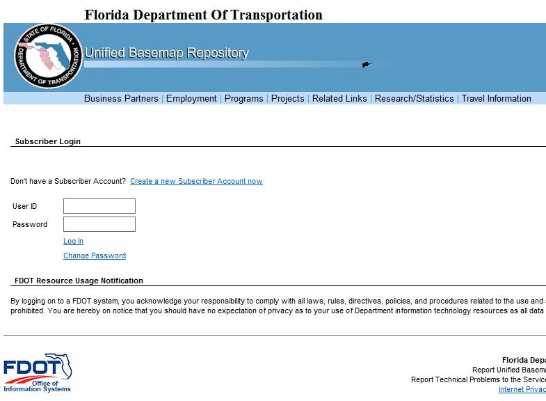
5 DATA ACCESS Who Governments and their contractors Where FDOT Unified Basemap Repository FDOT Staff Consultants / Contractors and Local Governments - Strava Heat Map

6 EXTERNAL ACCESS TO REPOSITORY

7 CONTRACTOR ACCESS TO REPOSITORY

8 CREATING A REPOSITORY ACCOUNT

9 REPOSITORY ERROR MESSAGE Send an to to request authorization
10 LEGAL REQUIREMENTS Data is proprietary Exempt from public records disclosure Working on public products Accessing Data Requires accepting user agreement Data must come from FDOT Metadata Credits Data Licensed from Strava (user license term 3.2)
11 DATA CHARACTERISTICS Summaries (segment and intersection) Yearly Total Weekday / Weekend Monthly Weekday / Weekend Seasonal Weekday / Weekend Raw Data (above + origin / destination) Minute scale for each segment and intersection Trip level for origin / destination
 / ID (Strava) fields Street Name / Alternate Street")
12 STREET NETWORK HERE NAVSTREETS 1.7 million street segments for entire state Available through the UBR Attributes Linked through LINK_ID (HERE) / ID (Strava) fields Street Name / Alternate Street Names Functional classification (not FDOT / FHWA) Travel Direction Speed Category Urban / Rural Divided / Undivided Licensed product
13 RIDE DATA CHARACTERISTICS 2015 Ride 964,463 activities 14% Commute trips 19 mile median trip 1.5 hour median trip % of Florida Users who provided an age 35% 30% 25% 20% 15% 10% 5% Strava Ride Age Distributions By Gender 0% Under Male Female
14 RUN DATA CHARACTERISTICS 2015 Run 507,388 activities 3.2 mile median trip 37 minute median trip % of Florida Users who provided an age 40% 35% 30% 25% 20% 15% 10% 5% 0% Strava Run Age Distributions By Gender Under Male Female
15 UNDERSTANDING THE FILE NAMES Edge = Street Segment Node = Intersection Rollup = Summary Season = On Season Strava default is April 1 through October 1 Fl_edges_2015_ride_rollup_month_2015 _1_weekday = Ride summary for street segments from January 1 st to 31 st 2015
16 DECODING THE FIELD NAMES ATH = Athlete ACT = Activities or Trips R = Reverse the line digitized direction A = With the line digitized direction T = Total CNT = Count CMT = Commute _0, _1, etc. = Time Period TATHCNT = Total athlete count for summary period RACTCNT_1 = Total trip count for AM peak (5 AM to 9:59 AM) for the summary period for trips taken against the street digitized direction

17 COMMUTE FLAG

18 BIKE VOLUME + CRASHES Early stages of understanding More work / research needed
 Users Average 44 users / segment Max 2,409 users (Westbound Rickenbacker")
19 SAMPLE DATA Dade County Ride Trips 29,866,103 total trips on 166,000 segments Average 179 trips / segment Max 24,129 trips (Westbound Rickenbacker Causeway) Users Average 44 users / segment Max 2,409 users (Westbound Rickenbacker Causeway)
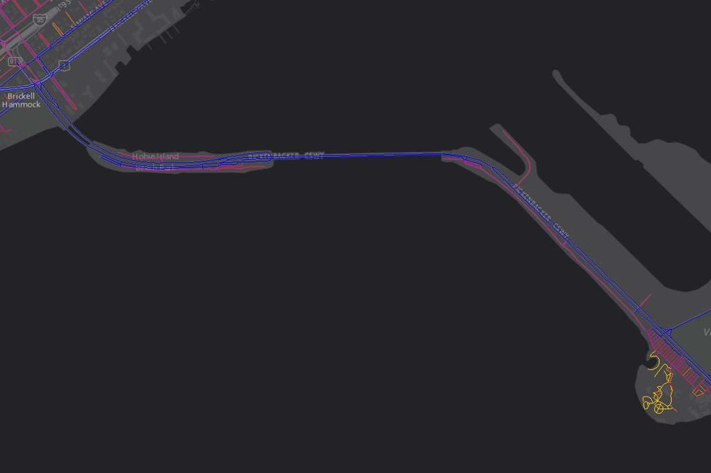
20 RICKENBACKER CAUSEWAY
 Late Night (8 PM to")
21 USE BY TIME OF DAY AM Peak (5 AM to 10 AM) PM Peak (3 PM to 8 PM) Late Night (8 PM to Midnight)


22 INTERSECTION DATA Counts Time Spent at Intersection

23 ORIGIN / DESTINATION DATA Morning Commute Trips to downtown Miami Evening Commute Trips from downtown Miami Data Characteristics: Census Block Group Record per trip Origin Polygon Destination Polygon Polygon Path


24 ORIGIN / DESTINATION DATA Negative Flow Positive Flow AM PEAK PM PEAK
25 DIGITIZED DIRECTION VS. TRAVEL DIRECTION

26 CELL SIGNAL QUALITY Uses cell towers, not GPS Location accuracy is not exact Trees, buildings and hills can impact quality
27 USE CASES Measuring relative bike volume Estimating actual bike trips Data needs Limitations Route choice Route characteristics Safety Analysis

28 TOTAL ACTIVITY COUNT Fewer Trips More Trips
29 ESTIMATING ACTUAL BIKE TRIPS Data Needs Field Count Time Period Time Scale Count Locations Limitations Market growth Extrapolation Small sample size


30 50 45 Strava Bike Trips and Observed Bike Trips - District 4 10% A1A - N. of Palmetto Park Rd % STRAVA COUNT Hillsboro Inlet Hillsboro Inlet % A1A - N. of Palmetto Park Rd % FIELD COUNT
31 Day of the Year STRAVA GROWTH Counts for Westbound Rickenbacker Causeway ~2.2 X growth from 2012 to 2013 ~1.5 X growth from 2013 to Number of Trips
32 DATA CLEANING AND LIMITATIONS Cleaning Removed Trips on Limited Access Facilities Run Commutes Limitations User base Cell signal quality
33 ACCESS TO PRIOR TRAININGS Training from Strava (August 2015) Overview (Part 1) Product Details (Part 2) Use Cases (Part 3) FDOT Training (November 2015) Follow Up
34 CONTACT INFO Data Access: FDOT Transportation Statistics Office Chris Francis Safety: FDOT State Safety Office Shaun Davis Design / Planning: FDOT Roadway Design Office Dewayne Carver Dewayne.Carver@dot.state.fl.us
Bicycle and Pedestrian Level of Service Evaluation
 Bicycle and Pedestrian Level of Service Evaluation June 214 Florida Department of Transportation Bicycle and Pedestrian Evaluation Prepared by Sprinkle Consulting Cambridge Systematics For the Florida
Complete Streets and Context Classification
 Complete Streets and Context Classification April 2017 Secretary s Pedestrian Safety Initiative Dangerous by Design (2011, 2014) Orlando, Tampa, Jacksonville, Miami-Ft. Lauderdale Secretary Ananth Prasad
Do As I Say Not As I Do: Observed Compliance vs. Stated Understanding of Pedestrian Crossing Laws in Florida
 Do As I Say Not As I Do: Observed Compliance vs. Stated Understanding of Pedestrian Crossing Laws in Florida Achilleas Kourtellis, Ph.D. July 9, 2015 CUTR Webcast Series Center for Urban Transportation
95 Express Annual Operations Report: Fiscal Year
 95 Express Annual Operations Report: Fiscal Year 2014-2015 General The 95 Express Program completed its sixth full Fiscal Year of operations in June 2015. For the FDOT, its Fiscal Year (FY) is from July
South Florida Commuter Travel Survey Summary and Preliminary Results. Southeast Florida FSUTMS User Group Meeting June 1, 2012
 South Florida Commuter Travel Survey Summary and Preliminary Results Southeast Florida FSUTMS User Group Meeting June 1, 2012 Agenda Introduction Survey Design Survey Implementation Preliminary Findings
Marin County. Nonmotorized Transportation Pilot Program. Bicycle and Pedestrian Counts Update
 Marin County Nonmotorized Transportation Pilot Program Bicycle and Pedestrian Counts 2013 Update Prepared for: County of Marin Department of Public works Contact: Dan Dawson walkbikemarin@marincounty.org
LANE ELIMINATION PROJECTS
 PRESENTATION OUTLINE Lane Elimination Considerations Districts 4 & 7 Draft Lane Elimination Processes FDOT Lane Elimination Guidelines Example Projects D4 Case Study: SR A1A (Ft. Lauderdale) D7 Case Study:
FINAL DESIGN TRAFFIC TECHNICAL MEMORANDUM
 FINAL DESIGN TRAFFIC TECHNICAL MEMORANDUM July 2014 FINAL (SR 43) Project Development and Environment Study From State Road 60 (Adamo Drive) to I-4 (SR 400) Hillsborough County, Florida Work Program Item
CITY OF COCOA BEACH 2025 COMPREHENSIVE PLAN. Section VIII Mobility Element Goals, Objectives, and Policies
 CITY OF COCOA BEACH 2025 COMPREHENSIVE PLAN Section VIII Mobility Element Goals, Objectives, and Policies Adopted August 6, 2015 by Ordinance No. 1591 VIII MOBILITY ELEMENT Table of Contents Page Number
US 41 COMPLETE STREETS CORRIDOR PLANNING STUDY from University Parkway to Whitfield Avenue
 41 US 41 COMPLETE STREETS CORRIDOR PLANNING STUDY from University Parkway to Whitfield Avenue EXECUTIVE SUMMARY DRAFT FEBRUARY 2019 Project Overview The US 41 Complete Streets Corridor Planning Study,
Chapter 4 Traffic Analysis
 Chapter 4 Traffic Analysis PURPOSE The traffic analysis component of the K-68 Corridor Management Plan incorporates information on the existing transportation network, such as traffic volumes and intersection
List of Exhibits...ii
 One Brickell Traffic Study TABLE OF CONTENTS List of Exhibits...ii EXECUTIVE SUMMARY...1 1. INTRODUCTION...2 1.1 Study Area...2 1.2 Study Objective...5 2. EXISTING TRAFFIC CONDITIONS...6 2.1 Data Collection...6
Traffic Impact Statement
 Traffic Impact Statement Mixed Use Development, US 41 and Old Trail Drive aka Tide-Starbucks 4900 9 th Street North General Development Site Plan (GDSP) Collier County, FL 10/6/2015 Prepared for: Prepared
MONROE COUNTY NEW YORK
 MONROE COUNTY NEW YORK Intersection Accident Database Enhancement Project (UPWP 4380) FINAL January 2008 Prepared By: Prepared For: Bergmann Associates 200 First Federal Plaza 28 East Main Street Rochester,
APPENDIX G: INTERSECTION NEEDS AT OKEECHOBEE BOULEVARD
 APPENDIX G: INTERSECTION NEEDS AT OKEECHOBEE BOULEVARD INTERSECTION NEEDS AT SR 7 and OKEECHOBEE BOULEVARD SR 7 Extension Project Development and Environment (PD&E) Study From Okeechobee Boulevard (SR
We support several of Regional Municipality of Durham Transportation Master Plan Directions such as
 OATAC-17-26 Relates to Item 1 of the O.A.T.A.C. Report (DS-17-164) We support several of Regional Municipality of Durham Transportation Master Plan Directions such as Direction 3: Make walking and cycling
Overview of Pinellas County Pedestrian Safety Programs and Initiatives
 Overview of Pinellas County Pedestrian Safety Programs and Initiatives FHWA Pedestrian Safety Peer Exchange Miami, FL August 2, 2012 Peter Hsu, P.E. District Safety & Special Projects Engineer Florida
Overview of FDOT District 7 Safety Programs and Initiatives in Tampa Bay, FL
 Overview of FDOT District 7 Safety Programs and Initiatives in Tampa Bay, FL Executive Safety Summit Florida Department of Transportation District 7 June 8, 2011 Peter Hsu, P.E. District Safety & Special
Plant City Walk-Bike Plan
 Plant City Walk-Bike Plan Plant City Commute Mode Share 2.2% 1.4% 2.9% Drove alone 10.2% Carpooled Public transportation (0.1%) Walked Used a Bike (0.4%) 82.9% Taxicab, motorcycle, or other means Worked
Space Coast Transportation Planning Organization. Agenda
 2014 Countywide Safety Report Space Coast Transportation Planning Organization 1 Agenda Goals and Objectives Project Methodology Crash Data and Trends Intersection Analysis Corridor Analysis Strategic
Safety Emphasis Areas & Safety Project Development Florida Department of Transportation District Seven Tampa Bay
 Safety Emphasis Areas & Safety Project Development Florida Department of Transportation District Seven Tampa Bay Stephen L. Benson, AICP, CNU-A FDOT District Seven Safety Office Presentation Overview Safety
Overview. Illinois Bike Summit IDOT Complete Streets Policy Presentation. What is a Complete Street? And why build them? And why build them?
 Overview Illinois Bike Summit IDOT Complete Streets Policy Presentation Aren Kriks, P.E. District One Bicycle Coordinator and Bureau of Programming Project Engineer History of Complete Streets IDOT Policy
US 1 Express Lanes Public Kick-Off Meeting
 US 1 Express Lanes Project Development & Environment (PD&E) Study Public Kick-Off Meeting September 7 & 8, 2011 Miami Dade County, Florida 1 Presentation Agenda Introduction to MDX Background to PD&E studies
US 81 CORRIDOR STUDY FROM NORTH OF UNION CITY SOUTH TO SH 19 SOUTH OF CHICKASHA CANADIAN AND GRADY COUNTIES, OKLAHOMA JULY 2007
 US 81 CORRIDOR STUDY FROM NORTH OF UNION CITY SOUTH TO SH 19 SOUTH OF CHICKASHA CANADIAN AND GRADY COUNTIES, OKLAHOMA JULY 2007 PREPARED BY THE RESEARCH AND PLANNING DIVISION OKLAHOMA DEPARTMENT OF TRANSPORTATION
REGIONAL PRIORITIES Presentation to the Tampa Bay Regional Collaboration Committee September 10, 2012
 WEST CENTRAL FLORIDA MPO CHAIRS COORDINATING COMMITTEE REGIONAL PRIORITIES Presentation to the Tampa Bay Regional Collaboration Committee September 10, 2012 TRANSPORTATION REGIONAL INCENTIVE PROGRAM (TRIP)
Pine Hills Road Pedestrian/Bicycle Safety Study Board of County Commissioners Work Session
 Pine Hills Road Pedestrian/Bicycle Safety Study Board of County Commissioners Work Session February 20, 2018 Meeting Agenda Study Overview Existing Conditions Access Management Potential Gateway Features
National Performance Management Measures. April 20, 2016 Webinar
 Safety Performance Measures September 26, 2016 National Performance Management Measures April 20, 2016 Webinar Highway Safety Improvement Program Performance Measures 1 2 3 4 5 Number of fatalities Rate
Temporal and Spatial Variation in Non-motorized Traffic in Minneapolis: Some Preliminary Analyses
 Temporal and Spatial Variation in Non-motorized Traffic in Minneapolis: Some Preliminary Analyses Spencer Agnew, Jason Borah, Steve Hankey, Kristopher Hoff, Brad Utecht, Zhiyi Xu, Greg Lindsey Thanks to:
2017 Census Reporting To access the SOI s Census Reporting web site go to:
 To access the SOI s Census Reporting web site go to: https://census.specialolympics.org/login You will need to enter your username (valid email address) and password. If you have not received your password
SNCC Demographic Trends
 Employment Population SNCC Demographic Trends In 1970 the SNCC population was 10,040, accounting for roughly 3% of the County population In 2015, SNCC grew to 60,567 people, roughly 11% of the County population
Florida DOT Case Study
 Florida DOT Case Study 1 Background In 2013, MetroPlan Orlando became one of the first planning agencies in the world to use Strava Metro data to make better decisions about where to improve bicycle and
Chapter 5 DATA COLLECTION FOR TRANSPORTATION SAFETY STUDIES
 Chapter 5 DATA COLLECTION FOR TRANSPORTATION SAFETY STUDIES 5.1 PURPOSE (1) The purpose of the Traffic Safety Studies chapter is to provide guidance on the data collection requirements for conducting a
2015 Florida Main Street Annual Conference. Complete Streets Equal Stronger Main Streets
 WHAT ARE COMPLETE STREETS? CASE STUDIES COMPLETING YOUR MAIN STREET 2015 Florida Main Street Annual Conference St. Petersburg, Florida August 19, 2015 WHAT ARE COMPLETE STREETS? CASE STUDIES COMPLETING
Planning Study SR 976. Project Advisory Team Meeting May 24, 2017
 ` SR 976 BIRD ROAD/SW 40TH STREET FROM SR 821/HEFT TO SR 5/US-1 Miami-Dade County, Florida FPID No.: 434845-4-22-01 Planning Study Project Advisory Team Meeting May 24, 2017 1 Agenda Introductions Project
Travel and Rider Characteristics for Metrobus
 Travel and Rider Characteristics for Metrobus 040829040.15 Travel and Rider Characteristics for Metrobus: 2012-2015 Overview The Miami Dade County Metropolitan Planning Organization (MPO) conducted a series
TRANSPORTATION FACILITY PLANNING Waugh Chapel Road Maytime Drive to New Market Lane
 July 24, 2018 TRANSPORTATION FACILITY PLANNING Waugh Chapel Road Maytime Drive to New Market Lane DPWandYOU.com Making a difference, together Meeting Agenda Purpose of the project Overview of work conducted
North Carolina. Bicycle Crash Facts Prepared for
 North Carolina Bicycle Crash Facts 2006-2010 Prepared for The North Carolina Department of Transportation Division of Bicycle and Pedestrian Transportation Prepared by The University of North Carolina
TABLE OF CONTENTS. Executive Summary
 Executive Summary Background... ES-1 Pedestrian Network... ES-2 Bikeway Network... ES-2 Collision History... ES-2 Public Input... ES-4 Conclusions and Recommendations... ES-4 1. Introduction and Setting
Conducting Bicycle and Pedestrian Counts in Your Community: Count Manager Training. MnDOT and MDH Bicycle and Pedestrian Counting Initiative 2015
 Conducting Bicycle and Pedestrian Counts in Your Community: Count Manager Training MnDOT and MDH Bicycle and Pedestrian Counting Initiative 2015 Objectives 1. Understand what the Bike/Ped Count Program
2003 Virginia Department of Transportation Daily Traffic Volume Estimates. Special Locality Report 198
 2003 Virginia Department of Transportation Daily Traffic Volume Estimates Special Locality Report 198 Prepared By Virginia Department of Transportation Mobility Management Division In Cooperation With
RSA Efforts in the Tampa Bay Area
 RSA Efforts in the Tampa Bay Area Presentation to the RSA Regional Peer Exchange April 29, 2008 -- Little Rock, Arkansas Peter Hsu, PE, Florida Department of Transportation District 7 Overview Introduction
Typical Rush Hour Commute. PennyforTransportation.com
 Typical Rush Hour Commute In the News Overview of the Plan Collaborative plan with projects in every community Prioritizing connectivity and congestion relief Dedicated transportation-specific funding;
Growing Bicycle Travel & Tourism for Economic Development Jeff Miller, VP North America
 Growing Bicycle Travel & Tourism for Economic Development Jeff Miller, VP North America 202-445-4415 Jeff@CycleLifeHQ.com 1 2 3 4 Growing Bicycle Travel & Tourism for Economic Development Jeff Miller,
BOARD OF COUNTY COMMISSIONERS AGENDA ITEM SUMMARY
 7B BOARD OF COUNTY COMMISSIONERS AGENDA ITEM SUMMARY PLACEMENT: REQUESTS AND PRESENTATIONS PRESET: TITLE: FLORIDA DEPARTMENT OF TRANSPORTATION (FDOT) PRESENTATION RECONSTRUCTION OF SR-76 (SW KANNER HIGHWAY)
Cynemon - Cycling Network Model for London
 1 MARCH 2017 Cynemon - Cycling Network Model for London Aled Davies TfL Planning 2 Background Investment in cycling has increased significantly in recent years We need robust appraisal to justify cycling
DKS & WASHINGTON COUNTY Washington County Transportation Survey
 PREPARED FOR: DKS & WASHINGTON COUNTY Washington County Transportation Survey April 2013 PREPARED BY: DHM RESEARCH (503) 220-0575 239 NW 13 th Ave., #205, Portland, OR 97209 www.dhmresearch.com 1 INTRODUCTION
Acknowledgements. Ms. Linda Banister Ms. Tracy With Mr. Hassan Shaheen Mr. Scott Johnston
 Acknowledgements The 2005 Household Travel Survey was funded by the City of Edmonton and Alberta Infrastructure and Transportation (AIT). The survey was led by a steering committee comprised of: Dr. Alan
2002 Virginia Department of Transportation Daily Traffic Volume Estimates. Special Locality Report 209
 2002 Daily Traffic Volume Estimates Special Locality Report 209 Prepared By Mobility Management Division In Cooperation With U.S. Department of Transportation Federal Highway Administration Mobility Management
Access Management in the Vicinity of Intersections
 Access Management in the Vicinity of Intersections FHWA-SA-10-002 Technical Summary Photo: Ralph Bentley (used with permission) 0 Access Management is: The design, implementation and management of entry
Planning Transit Operations and Bike Sharing Denver RTD. Bill Van Meter, Assistant General Manager, Planning March 23, 2012
 Planning Transit Operations and Bike Sharing Denver RTD Bill Van Meter, Assistant General Manager, Planning March 23, 2012 1 Overview RTD Background RTD Bike-n-Ride Program RTD - Bike Share Coordination:
Tulsa Metropolitan Area LONG RANGE TRANSPORTATION PLAN
 Tulsa Metropolitan Area LONG RANGE TRANSPORTATION PLAN Indian Nations Council of Governments August 2005 CONTACTING INCOG In developing the Destination 2030 Long Range Transportation Plan, INCOG s Transportation
Completing the Vision
 Villas of Positano Completing the Vision North A1A Lane Reconfiguration N. Surf Rd. Redirection of Traffic Margaritaville Resort March 4, 2014 1 Completing The Vision Project Limits Hollywood Blvd. to
Transportation Trends, Conditions and Issues. Regional Transportation Plan 2030
 Transportation Trends, Conditions and Issues Regional Transportation Plan 2030 23 Regional Transportation Plan 2030 24 Travel Characteristics Why Do People Travel? Over one-half of trips taken in Dane
Sustainable Transportation Initiatives and Plans in Caledon
 Sustainable Transportation Initiatives and Plans in Caledon Arash Olia, P.Eng., PhD. Coordinator, Transportation Development Finance & Infrastructure Services Town of Caledon Eric Chan, P.Eng., PMP Manager,
GIS for Public Opinion / Survey Research. Timothy Michalowski Senior Statistical GIS Analyst Abt SRBI - New York, NY
 GIS for Public Opinion / Survey Research Timothy Michalowski Senior Statistical GIS Analyst Abt SRBI - New York, NY July 17, 2014 Agenda Introduction Public Opinion / Survey Research Application of GIS
Traffic Safety Barriers to Walking and Bicycling Analysis of CA Add-On Responses to the 2009 NHTS
 Traffic Safety Barriers to Walking and Bicycling Analysis of CA Add-On Responses to the 2009 NHTS NHTS Users Conference June 2011 Robert Schneider, Swati Pande, & John Bigham, University of California
State of the System Report. Agenda. Trends Summary. Corridor Analysis. Safety Analysis
 2017 State of the System Report SPACE COAST TRASPORTATIO PLAIG ORGAIZATIO TAC/CAC September 10, 2018 TPO Board September 13, 2018 Agenda s Summary Corridor Analysis Traffic Volumes and Congestion Evacuation
Moving Together Conference Complete Streets from the MassDOT District 5 Perspective
 Moving Together Conference Complete Streets from the MassDOT District 5 Perspective Timothy Kochan, Transportation Planner and Bicycle/ Pedestrian Coordinator District 5 Office Taunton S Overview of District
GIS Based Non-Motorized Transportation Planning APA Ohio Statewide Planning Conference. GIS Assisted Non-Motorized Transportation Planning
 The Purpose of GIS Assisted Network GIS Assisted Non-Motorized Transportation 2011 APA Ohio Statewide Conference Friday, 10:45 AM to Noon Focus on near-term projects wwwgreenwaycollabcom The purpose of
Route 29 Solutions Projects
 Route 29 Solutions Route 29 Solutions Projects www.route29solutions.org October 10, 2014 Route 29 Widening to Six Lanes Albemarle County This project will widen a 1.8-mile segment of Route 29 from four
2002 Virginia Department of Transportation Daily Traffic Volume Estimates Including Vehicle Classification Estimates. Special Locality Report 261
 2002 Daily Traffic Volume Estimates Including Vehicle Classification Estimates where available Special Locality Report 261 Prepared By In Cooperation With U.S. Department of Transportation Federal Highway
Iowa Corridor Management Pilot Project Overview. Recommendations For A Corridor Management Program August 2004
 Iowa Corridor Management Pilot Project Overview Recommendations For A Corridor Management Program August 2004 Presentation Overview Project goals Pilot project selection process Analysis results Segment
Compression Study: City, State. City Convention & Visitors Bureau. Prepared for
 : City, State Prepared for City Convention & Visitors Bureau Table of Contents City Convention & Visitors Bureau... 1 Executive Summary... 3 Introduction... 4 Approach and Methodology... 4 General Characteristics
BEAR CREEK PARK AND RIDE
 BEAR CREEK PARK AND RIDE 7760 178th Pl NE, Redmond, WA 98052 700 Average weekday transit boardings 283 Parking spaces Owned by King County Metro Served by Sound Transit and King County Metro Bear Creek
Bike Routes Assessment: 95 Ave, 106 St & 40 Ave. Replace with appropriate image in View > Master.
 Bike Routes Assessment: 95 Ave, 106 St & 40 Ave Replace with appropriate image in View > Master. Transportation Committee October 15, 2014 City Council Direction What we are trying to achieve The Way Ahead:
North Augusta 1215 Knox Avenue, North Augusta, SC 29841
 EXECUTIVE SUMMARY PROPERTY SUMMARY Available SF: Lease Rate: Lot Size: Building Size: 2,000-2,500 SF $17.00 - $19.00 SF/yr (NNN) 9.65 Acres 45,160 SF PROPERTY OVERVIEW The is a very strong Walmart shadow
FDOT Bicycle/Pedestrian Focused Initiative & Complete Streets
 Florida Department of TRANSPORTATION FDOT Bicycle/Pedestrian Focused Initiative & Complete Streets DeWayne Carver, AICP State Bicycle/Pedestrian Coordinator Secretary s Pedestrian Safety Initiative Dangerous
Summary of Travel Trends Findings from the 2017 NHTS. Nancy McGuckin, Travel Behavior Analyst Anthony Fucci, Westat
 1 Summary of Travel Trends Findings from the 2017 NHTS Nancy McGuckin, Travel Behavior Analyst Anthony Fucci, Westat 2 A BIG thank you to: FHWA Team: Danny Jenkins, FHWA Stacey Bricka, Macrosys Tim Reusher,
Access Management Regulations and Standards
 Access Management Regulations and Standards Efficient highway operation Reasonable property access Concept of Access Management The way to manage access to land development while simultaneously preserving
ADOT Statewide Bicycle and Pedestrian Program Summary of Phase IV Activities APPENDIX B PEDESTRIAN DEMAND INDEX
 ADOT Statewide Bicycle and Pedestrian Program Summary of Activities APPENDIX B PEDESTRIAN DEMAND INDEX May 24, 2009 Pedestrian Demand Index for State Highway Facilities Revised: May 29, 2007 Introduction
Access Management Regulations and Standards
 Access Management Regulations and Standards January 2014 Efficient highway operation Reasonable property access Concept of Access Management The way to manage access to land development while preserving
Basketball Entry Form Instructions
 Basketball Entry Form Instructions General Information: The following instructions will assist you in completing the entry forms for the Special Olympics Indiana State Basketball Competition. There are
Report. Typical Sections. City of Middleton, WI
 Report Typical Sections City of Middleton, WI December 2006 Report for City of Middleton, Wisconsin Typical Sections repared by: Traffic Associates LLC and STRAND ASSOCIATES, INC. 910 West Wingra Drive
Highway 12 Safety Coalition
 Highway 12 Safety Coalition City of Wayzata, City of Long Lake, City of Orono, City of Medina, City of Maple Plain, City of Independence, City of Delano, City of Montrose, City of Waverly, City of Howard
Saturday 12:00 p.m 2:00 p.m Bicycle Pedestrian
 Overall Trip Numbers by Time Period Weekday 5:00 p.m. 7:00 p.m. Saturday 12:00 p.m 2:00 p.m. 2009 2010 2009 2010 Bicycle 216 336 180 260 Pedestrian 1384 1362 1936 2507 Summary by Location Count locations
Thank you for this opportunity to discuss with you how we can work together to make our streets more complete.
 Thank you for this opportunity to discuss with you how we can work together to make our streets more complete. 1 2 3 Thank you for this opportunity to discuss with you how we can work together to make
95 th Street Corridor Transportation Plan. Steering Committee Meeting
 95 th Street Corridor Transportation Plan Steering Committee Meeting August 11, 2014 PROJECT OBJECTIVES Develop a Transportation and Economic Plan for the 95 th Street Corridor Improve public transit efficiency
Design Traffic Technical Memorandum
 State Road 7 Extension PD&E Study Design Traffic Technical Memorandum Palm Beach County, FL October 2010 State Road 7 Extension PD&E Study Design Traffic Technical Memorandum Palm Beach County, FL Prepared
City of Charlottesville Bicycle and Pedestrian Master Plan Update
 City of Charlottesville Bicycle and Pedestrian Master Plan Update September 17, 2014 I. Welcome and meeting overview II. Project status update III. Network overview IV. Break-out groups Pedestrian Network
1999 On-Board Sacramento Regional Transit District Survey
 SACOG-00-009 1999 On-Board Sacramento Regional Transit District Survey June 2000 Sacramento Area Council of Governments 1999 On-Board Sacramento Regional Transit District Survey June 2000 Table of Contents
New Data for Vermont and our Communities: A Focus on Programs of the U.S. Census Bureau Town Officer Education Seminars uvm.
 New Data for Vermont and our Communities: A Focus on Programs of the U.S. Census Bureau 2011 Town Officer Education Seminars Our Focus Today Accessing the Data Target to serve 2010 Census and ACS 5 year
Measuring and growing active modes of transport in Auckland
 AUCKLAND CLIENT TRANSPORT SECTION HEADLINE1 AUCKLAND TRANSPORT JUNE 2017 Measuring and growing active modes of transport in Auckland WAVE 3 1 AUCKLAND TRANSPORT 2 The overall business objective is to:
Creating Complete Streets to Accommodate All Users
 Creating Complete Streets to Accommodate All Users Peter Lagerwey, Toole Design Group plagerwey@tooledesign.com Brian Dougherty, Seattle DOT brian.dougherty@seattle.gov International Conference on Urban
METHODOLOGY. Signalized Intersection Average Control Delay (sec/veh)
") Chapter 5 Traffic Analysis 5.1 SUMMARY US /West 6 th Street assumes a unique role in the Lawrence Douglas County transportation system. This principal arterial street currently conveys commuter traffic
Chapter 5 Traffic Analysis 5.1 SUMMARY US /West 6 th Street assumes a unique role in the Lawrence Douglas County transportation system. This principal arterial street currently conveys commuter traffic
Exploring the relationship between Strava cyclists and all cyclists*.
 Exploring the relationship between Strava cyclists and all cyclists*. Dr. David McArthur, Dr. Jinhyun Hong, Dr. Mark Livingston, Kirstie English *This presentation contains preliminary results which are
2010 Virginia Department of Transportation Daily Traffic Volume Estimates Including Vehicle Classification Estimates. Special Locality Report 172
 2010 Daily Traffic Volume Estimates Including Vehicle Classification Estimates where available Special Locality Report 172 Town of Boyce Information in this report is included in Report (Clarke County)
MAKE YOUR PLACE IN CHANNELSIDE
 MAKE YOUR PLACE IN CHANNELSIDE INTRODUCTION PROJECT LIMITS Channelside Drive from Cumberland Ave to Kennedy Boulevard EXISTING CONDITIONS EXISTING CONDITIONS CHANNELSIDE DRIVE FROM E. CUMBERLAND AVENUE
Real-Life Cost of Incomplete Streets
 Real-Life Cost of Incomplete Streets Presented by: Sheree Davis New Jersey Department of Transportation State Bicycle & Pedestrian Coordinator 609.530.6551 sheree.davis@dot.state.nj.us 2011 New Jersey
2005 Virginia Department of Transportation Daily Traffic Volume Estimates Including Vehicle Classification Estimates. Special Locality Report 324
 2005 Virginia Department of Transportation Daily Traffic Volume Estimates Including Vehicle Classification Estimates where available Special Locality Report 324 Prepared By Virginia Department of Transportation
Executive Summary. TUCSON TRANSIT ON BOARD ORIGIN AND DESTINATION SURVEY Conducted October City of Tucson Department of Transportation
 Executive Summary TUCSON TRANSIT ON BOARD ORIGIN AND DESTINATION SURVEY Conducted October 2004 Prepared for: City of Tucson Department of Transportation May 2005 TUCSON TRANSIT ON BOARD ORIGIN AND DESTINATION
Eliminate on-street parking where it will allow for a dedicated bus only lane %
 Traffic Dashboard Priorities Survey Responses Introduction 1) Are you familiar with bus rapid transit (BRT)? a. No, BRT is new to me. 597 23.5% b. I ve heard of BRT, but I don t know much about it. 1,136
BETHEL ROAD AND SEDGWICK ROAD CORRIDOR STUDY
 DRAFT PLAN City Council Meeting August 14, 2017 STUDY AREA Sedgwick Corridor State Route 160, principal arterial with Class 3 access management designation, commuter and freight route, connection to SR
Mile Marker Signs and the. David DiNocco Transportation Planner Massachusetts Department of Transportation
 Mile Marker Signs and the Linear Referencing System David DiNocco Transportation Planner Massachusetts Department of Transportation Agenda 2 Introduction MA Road Inventory Database Why Replace Mile Markers?
Introduction to Sugar Access. Sugar Access - Measuring Accessibility (Robert Kohler, Citilabs) Slide 1 of 21
 Slide 1 of 21") Introduction to Sugar Access Sugar Access - Measuring Accessibility (Robert Kohler, Citilabs) Slide 1 of 21 Walkability, Livability, Accessibility http://www.citilabs.com/sugaraccess Sugar Access - Measuring
Introduction to Sugar Access Sugar Access - Measuring Accessibility (Robert Kohler, Citilabs) Slide 1 of 21 Walkability, Livability, Accessibility http://www.citilabs.com/sugaraccess Sugar Access - Measuring
TRAFFIC IMPACT STUDY
 TRAFFIC IMPACT STUDY for the GLEN ELLEN COUNTRY CLUB SENIOR RESIDENTIAL REDEVELOPMENT 84 Millis, Massachusetts Prepared by: McMahon Associates, Inc. Prepared for: Toll Brothers, Inc. August 216 DRAFT
2016 Virginia Department of Transportation Daily Traffic Volume Estimates Including Vehicle Classification Estimates
 2016 Virginia Department of Transportation Daily Traffic Volume Estimates Including Vehicle Classification Estimates where available Jurisdiction Report WV West Virginia repared By Virginia Department
National Bicycle and Pedestrian Documentation Project Conducting Counts
 National Bicycle and Pedestrian Documentation Project Conducting Counts Alta Planning + Design What is the NBPD? Annual bicycle and pedestrian count and survey effort A cooperative effort between Alta
Traffic Collision Statistics Report
 Traffic Collision Statistics Report 2016 Prepared by Tahir Hameed, M.Eng, P.Eng, PTOE Traffic Safety Engineer Debbie Rawson, M.Sc. Transportation Integration and Safety Advisor Transportation Planning
Washington County, Oregon
 Washington County, Oregon Photo add here 1 Washington County, Oregon Total population: 536,370 City population: 320,000 Based on 2010 Census Rural population: 26,000 Urban Unincorporated Population: 190,000
2014 QUICK FACTS ILLINOIS CRASH INFORMATION. Illinois Emergency Medical Services for Children February 2016 Edition
 2014 QUICK FACTS ILLINOIS CRASH INFORMATION February 2016 Edition Illinois Emergency Medical Services for Children www.luhs.org/emsc Illinois Emergency Medical Services for Children TABLE OF CONTENTS