Monitoring of Glacial Lakes & Water Bodies in the Himalayan Region of Indian River Basins for September, 2016
|
|
|
- Alban Carter
- 5 years ago
- Views:
Transcription
1

2 Monitoring of Glacial Lakes & Water Bodies in the Himalayan Region of Indian River Basins for September, 2016 Climate &IAD Directorate Central Water Commission Ministry of Water Resources, River Development & Ganga Rejuvenation New Delhi i
3 Document Control Sheet 1. Security Classification Restricted 2. Distribution 3. Report / Document Type Technical report 4. Document Control Number 5. Title This document is for use by Central Water Commission, Ministry of Water Resources, River Development & Ganga Rejuvenation, Govt. of India. CWC/CC&IAD/2016/TR 4 Monitoring of Glacial Lakes & Water Bodies in the Himalayan Region of Indian River Basins for September, Author(s) Sanjay Kumar Singh & Rakesh Kumar Gupta 7. Affiliation of authors 8. Project Team 9. Scrutiny mechanism Climate & IAD Directorate, CWC, New Delhi Sanjay Kumar Singh, Manoj Kumar, V.Vasanth Kumar & Rakesh Kumar Gupta Compiled by Reviewed by Approved / Controlled by Rakesh Kumar Gupta Sanjay Kumar Singh 10. Originating unit P&D organization, CWC, New Delhi 11. Date of Publication 27/10/2016 M.P. Singh 12. Abstract (with Keywords) : This document presents the details on monitoring of glacial lakes and water bodies in the Indian Himalayan region during the month of September 2016 using satellite remote sensing technique including the data used and methodology followed in this study. Keywords: Glacial Lake, Water Bodies, Himalayas, Remote Sensing, GLOF, AWiFS ii
4 S.NO. Contents Page No. List of Tables iv List of Figures iv Abbreviations v Executive Summary vi 1. Introduction Background Remote Sensing Technology Objectives 2 2. Study Area & Materials Study Area Materials Satellite Data 3 3. Methodology Orthorectification of Satellite Data Monitoring of Glacial Lakes & Water Bodies 5 4. Results 7 5. Conclusions 8 6. References 48 iii
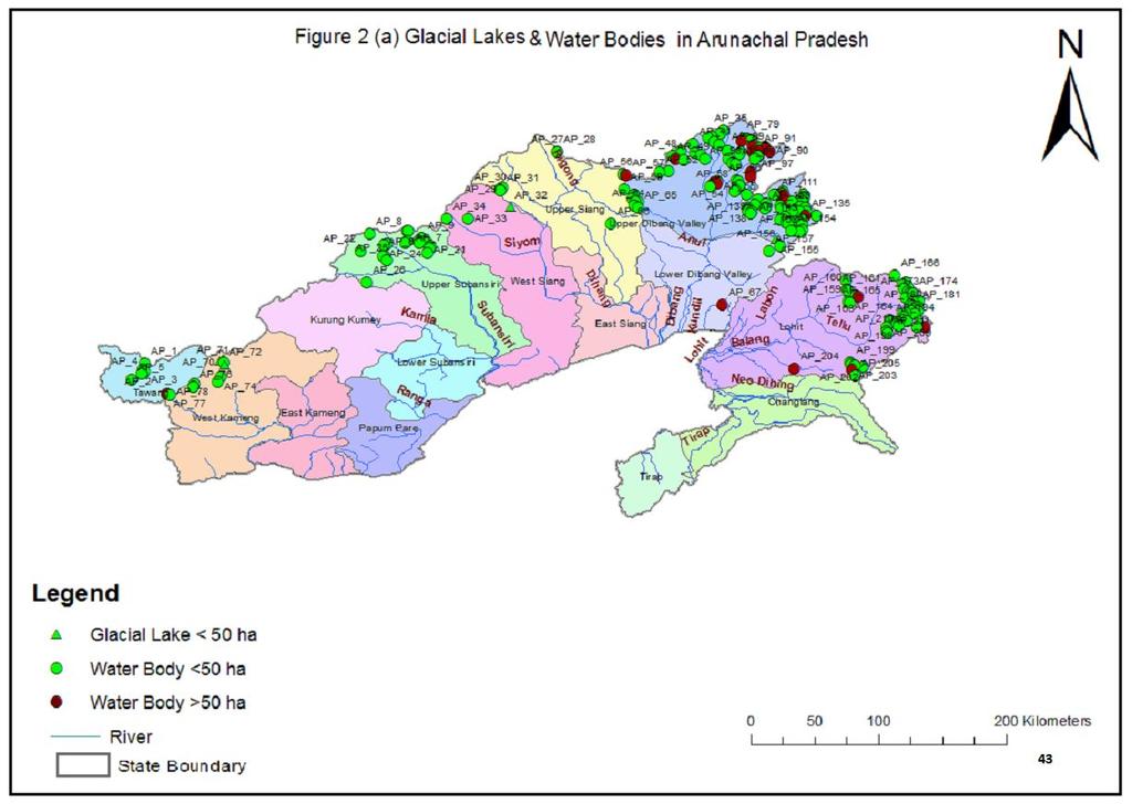
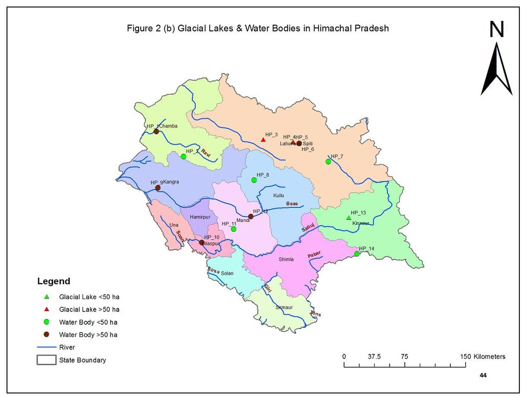
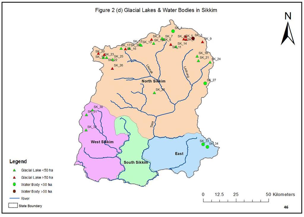
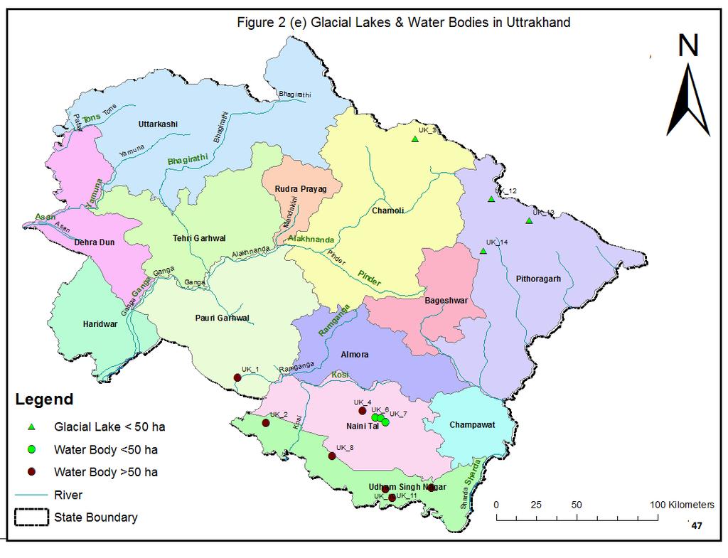
5 List of Tables S.NO. Table No. Particulars Page No. 1. Table 1 List of satellite data used 3 2. Table 2 Comparison of water spread area during September with inventory area 3. Table 2 (a) GL & WB that have shown DECREASE in water spread 9 4. Table 2 (b) GL & WB that have shown INCREASE in water spread Table 2 (c) GL & WB that have shown NO CHANGE in water spread Table 2 (d) GL & WB that are CLOUD COVERED Table 3 List of GL & WB with extreme change in water spread area Table 3 (a) List of GL & WB that have shown INCREASE in water spread area 10. Table 3 (b) List of GL & WB that have shown DECREASE in water spread area List of Figures S.NO. Table No. Particulars Page No. 1. Figure 1 Index map of study area 4 2. Figure 2 (a) Glacial Lakes & Water Bodies in Arunachal Pradesh Figure 2 (b) Glacial Lakes & Water Bodies in Himachal Pradesh Figure 2 (c) Glacial Lakes & Water Bodies in Jammu & Kashmir Figure 2 (d) Glacial Lakes & Water Bodies in Sikkim Figure 2 (e) Glacial Lakes & Water Bodies in Uttrakhand 47 iv
6 ABBREVIATIONS AP AWiFS DEM DIFF FCC GL GLOF HA HP J&K LAT LONG LU/LC NRSC SRTM UID UK WB Arunachal Pradesh Advanced Wide Field Sensor Digital Model Difference False Color Composite Glacial Lake Glacial lake Outburst Flood Hectare Himachal Pradesh Jammu & Kashmir Latitude Longitude Land Use /Land Cover National Remote Sensing Centre Shuttle Radar Topography Mission Unique Identification Uttrakhand Water Body v
7 Executive Summary Glacial lakes are common in the high elevation of glacierised basin. They are formed when glacial ice or moraines impound water. These lakes normally drain their water through seepage in front of the retreating glacier. Flash floods caused by the outburst of glacial lakes, called as Glacial Lake Outburst Flood (GLOF), are well known in Himalayan terrain, where such lakes are formed due to landslides. Satellite remote sensing based mapping and monitoring of the glacial lakes and water bodies, covering Indian Himalayan region, was taken up. The analysis done for September 2016 and comparison with inventory year of 2009 is presented here. Based on the current inventory, 415 glacial lakes & water bodies with a water spread area more than 50 ha are monitored. Apart from this, another 62 glacial lakes & water bodies with water spread area in the range 44 to 50 ha also have been monitored. Accordingly, a total of 477 glacial lakes & water bodies were considered for monitoring during The inputs for this report are received from NRSC, Hyderabad. Cloud free satellite data was available for only 195 glacial lakes & water bodies during September Water spread areas for the same were computed and compared with inventory area. Among them, 110 have shown decrease in water spread area, 29 have shown increase, 56 have not shown any significant change. It is also noted that 47 glacial lakes & water bodies have decreased by more than 20 and 12 glacial lakes & water bodies have shown increase in area by more than 20. vi
8 1. Introduction 1.1 Background Glacial lakes are common in the high elevation of glacierised basin. They are formed when glacial ice or moraines impound water. There are varieties of such lakes, ranging from melt water ponds on the surface of glacier to large lakes in side valleys dammed by a glacier in the main valley. These lakes normally drain their water through seepage in front of the retreating glacier. The moraine creates topographic depression in which the melt water is generally accumulated leading to formation of glacial lake. When this lake is watertight, melt waters will accumulate in the basin until seepage or overflow limits the lake level. Such moraine-dammed lakes appear to be the most common type of glacial lakes. The impoundment of the lake may be unstable, leading to sudden release of large quantities of stored water. Failure of these ice or moraine dams as very destructive events has been documented throughout the world. Flash floods caused by the outburst of glacial lakes, called as Glacial Lake Outburst Flood (GLOF), are well known in Himalaya where such lakes had been formed by landslides. Satellite remote sensing techniques are used to map, inventory and monitor the glacial lakes & water bodies in Indian Himalayan region, which is formed by joining the catchment of rivers draining in India. 1.2 Remote Sensing Technology Remote sensing is the science of acquiring information about the Earth's surface without actually being in contact with it. This is done by sensing and recording reflected or emitted energy and processing, analyzing, and applying that information. Satellite remote sensing technology contributed significantly to the acquisition of Earth s resources and thus helping for better management of these resources. Satellite remote sensing plays a complementary role to other means of spatial data acquisition i.e., through conventional procedures. Satellite remote sensing offers several unique advantages quick data collection, reliability, more accurate, repetitive collection, geometric integrity and digital storage, which makes it an ideal tool for mapping, inventorying and monitoring the natural resources. Glaciers and glacial lakes are generally located in remote areas, where access is through tough and difficult terrain. The inventory of glacial lakes using conventional methods requires extensive time and resources together with undergoing hardship in the field. Creating inventories and monitoring of the glacial lakes can be done quickly and correctly using satellite images and aerial photographs. Use of these images and photographs for the evaluation of physical conditions of the area provides greater accuracy. The multi-stage approach using remotely sensed data and field investigation increases the ability and accuracy of the work. Visual and digital image analysis techniques integrated with techniques of geographic information systems (GIS) are very useful for the study of glacier, glacial lakes. 1
9 1.3 Objectives The objective of the study is monitoring the changes in spatial extent of the glacial lakes & water bodies greater than 50 ha. on monthly basis during June to October,2016 using base year of The inventory of glacial lakes & water bodies in the Himalayan region of Indian river basin using satellite data of the year 2009 (Ref: NRSC Report)of glacial lakes/water bodies having spatial extent greater than 10 ha was prepared during the year The monitoring has been done for the years The changes in the current years will be analysed with respect to the year This report presents the details on the data used and methodology followed in monitoring of glacial lakes & water bodies in the Indian Himalayan region using satellite data in the month of September,
10 2.1 Study Area 2. Study Area & Materials The present study is carried out for the area covering Indian Himalayas. The study area extends across different countries namely India, Nepal, Bhutan and China. The index map showing study area is given in Figure Materials Advanced Wide Field Sensor(AWiFS) data from the Indian remote sensing satellite, Resourcesat-2 has been used in the study for monitoring of glacial lakes pertaining to current month Satellite Data - For the purpose of monitoring glacial lakes and water bodies from satellite images, it is preferable to have cloud free satellite images during the time of monitoring. Since the monitoring is carried out during monsoon period, probability of availability of cloud free data is less. Hence all the possible satellite data were browsed and checked for their coverage of the study area and cloud cover. The list of satellite data used for monitoring during September, 2016 is given in Table 1. Table 1. List of satellite data used S No Path Row Date September September September September September -16 3


11 Figure 1. Index map of study area 4
12 3. Methodology The monitoring of glacial lakes and water bodies in the Indian Himalayan region using satellite images involves the following steps. Ortho-rectification of satellite data Identification & digitization of glacial lakes & water bodies Organisation of database This chapter discusses each of the above steps in detail. 3.1 Orthorectification of Satellite Data Orthorectification is the process by which the geometric distortions of the image are modelled and accounted for, resulting in a planimetrically correct image. 3D world is imaged by most sensors in 2D and orthorectification corrects for many of the anomalies resultant from this conversion. Orthorectified imagery is particularly useful in areas of the world with exacerbated terrain features such as mountains, plateaus, etc. The orthorectification process yields map-accurate images which can be highly useful as base maps and may be easily incorporated into a GIS. The success of the orthorectification process depends on the accuracy of the DEM and the correction method. In this study, orthorectified data generated under AWiFS derived LU/LC project has been used. 3.2 Monitoring of Glacial Lakes & Water Bodies The glacial lakes & water bodies are delineated based on the visual interpretation of satellite images of Resourcesat2 AWiFS sensor. Identification of features was done through panchromatic mode and/or different colour combinations of the multi-spectral bands namely green, red, near infrared and shortwave infrared. To identify the glacial lakes & water bodies, different image enhancement techniques are used to improve the visual interpretation. This method is complimented with the knowledge and experience of the Himalayan terrain conditions for inventorying glacial lakes and water bodies. With different spectral band combinations in false colour composite (FCC) and in individual spectral bands, glacial lakes and water bodies can be identified. The knowledge of image interpretation keys: colour, tone, texture, pattern, association, shape, shadow, etc. will also enhance the capability of identifying these features. The water spread area of the lakes in false colour composite images ranges in appearance from light blue to blue to black. The frozen lakes appear white in colour. Sizes of water bodies are generally small, having circular, semi-circular, or irregular shapes with very fine texture. They are generally associated with glaciers in the case of high lying areas, or rivers in the case of low lying areas. 5
13 The present study proposed to monitor all the glacial lakes & water bodies that are larger than 50 ha in area. Even though during inventory, glacial lakes and water bodies having area more than 10 ha were digitised, monitoring was carried out only for the glacial lakes & water bodies that are larger than 50 ha. The boundary of glacial lakes and water bodies are digitized as polygon feature using on-screen digitisation techniques. The polygons are geo-processed and the water spread area of glacial lakes & water bodies were computed digitally. These steps were repeated for each date of satellite data and water spread area was computed. The maximum water spread area for each water body among the different dates of satellite in the month of September, 2016 has been considered for the final analysis of the change in water spread. The following criteria were followed while monitoring the water bodies. A change in water spread area within +/- 5 is considered to be no change. Partly or fully cloud covered or frozen water bodies have not been considered in monitoring. The spatial extent of water spread area during the current month has been mapped and compared with the spatial extent of water spread area mapped during
14 4. Results 4.1 Results The monitoring of glacial lakes and water bodies in the Himalayan region of Indian river basins was carried out through interpretation/analysis of IRS satellite images of AWiFS sensor. The basins covered under this study are Indus, Ganga and Brahmaputra. During inventory phase of the study, 433 glacial lakes & water bodies were identified that are having water spread area of more than 50 ha and monitoring was carried out during However, based on the directions that emerged from the Second meeting of Evaluation and Monitoring Committee for and Monitoring of Glacial lakes and Water Bodies in Himalayan Region of Indian River Basin held on , the inventory has been updated accordingly. Based on the current inventory, 415 glacial lakes & water bodies with a water spread area more than 50 ha are monitored. Apart from this, another 62 glacial lakes & water bodies with water spread area in the range 44 to 50 ha also have been monitored so that those glacial lakes & water bodies that have shown increase and have water spread area of more than 50 ha could also be monitored. Accordingly, a total of 477 glacial lakes & water bodies were considered for monitoring during The Glacial Lakes/Water Bodies has been divided in four categories based on the trend of area i.e. Increased, Decreased, No change and Cloud Covered. The water spread area for all these glacial lakes & water bodies monitored using satellite data in September, 2016 is provided in Table 2. The percentage difference in water spread area with reference to the inventory area is also provided. 7
15 5. Conclusions 5.1 Conclusions The analysis of water spread area of glacial lakes & water bodies monitored in September 2016 was done for only 195 glacial lakes & water bodies using cloud free satellite data. Based on this, it is found that 110 glacial lakes & water bodies have shown decrease in water spread area, 29 have shown increase, 56 have not shown any significant change (± 5). 47 glacial lakes & water bodies have decreased by more than 20 and 12 glacial lakes & water bodies have shown increase in area by more than 20. The list of such glacial lakes & water bodies is given in Table 3. 8
16 Table 2 Comparison of water spread area during September 2016 with inventory area Table 2(a) - GL & WB that have shown DECREASE in water spread 1 CH_256 02_77D_001 China Ganga Arun Kosi WB 2 CH_59 01_61F_002 China Indus Indus WB 3 CH_316 03_62K_012 China Brahmaputra GL 4 CH_28 01_61B_003 China Indus Indus WB 5 CH_251 02_72M_005 China Ganga Arun Kosi GL 6 CH_60 01_61F_003 China Indus Indus WB 7 CH_388 03_62O_043 China Brahmaputra WB 8 NP_78 02_72I_025 Nepal Nepal Ganga Sun Kosi GL 9 CH_62 01_61G_001 China Indus Indus WB 10 HP_9 01_53A_001 HP Kangra India Indus Beas WB 11 BH_4 03_77H_011 Bhutan Brahmaputra GL 12 NP_64 02_72I_011 Nepal Nepal Ganga Sun Kosi GL 13 CH_252 02_72M_006 China Ganga Arun Kosi GL 14 CH_203 02_71P_015 China Ganga Arun Kosi WB 15 CH_56 01_61D_004 China Indus Indus WB 16 CH_73 01_62B_001 China Indus Satluj WB 17 SK_2 03_77D_002 Sikkim North Sikkim India Brahmaputra Teesta GL 9
17 18 CH_373 03_62O_028 China Brahmaputra WB 19 CH_259 02_77D_004 China Ganga Arun Kosi WB 20 CH_51 01_61C_023 China Indus Indus WB 21 CH_476 03_77H_001 China Brahmaputra WB 22 CH_326 03_62N_009 China Brahmaputra WB 23 SK_4 03_77D_004 Sikkim 24 JK_205 01_52J_009 J&K North Sikkim Ladakh (Leh) India Brahmaputra Teesta GL India Indus Shyok WB 25 CH_604 03_78E_006 China Brahmaputra WB 26 CH_384 03_62O_039 China Brahmaputra WB 27 CH_207 02_71P_019 China Ganga Arun Kosi GL 28 HP_10 01_53A_002 HP Bilaspur India Indus Satluj WB 29 CH_640 03_82B_014 China Brahmaputra WB 30 SK_16 03_78A_009 Sikkim North Sikkim India Brahmaputra Teesta GL 31 JK_196 01_52I_004 J&K India Indus Shyok WB Ladakh 32 JK_201 01_52J_005 J&K (Leh) India Indus Shyok WB 33 CH_90 01_62E_015 China Indus Satluj WB 34 CH_320 03_62N_003 China Brahmaputra WB 10
18 35 CH_419 03_71G_010 China Brahmaputra WB 36 CH_50 01_61C_022 China Indus Indus WB 37 NP_19 02_62J_003 Nepal Nepal Ganga Karnal WB 38 CH_495 03_77H_030 China Brahmaputra WB 39 CH_377 03_62O_032 China Brahmaputra WB 40 CH_606 03_78E_010 China Brahmaputra WB 41 CH_385 03_62O_040 China Brahmaputra WB 42 CH_430 03_71K_007 China Brahmaputra WB 43 CH_564 03_77O_001 China Brahmaputra WB North 44 SK_3 03_77D_003 Sikkim Sikkim India Brahmaputra Teesta WB 45 CH_347 03_62O_002 China Brahmaputra WB Ladakh 46 JK_197 01_52J_001 J&K (Leh) India Indus Shyok GL 47 CH_372 03_62O_027 China Brahmaputra WB 48 NP_45 02_71D_004 Nepal Nepal Ganga Trisuli GL 49 CH_284 03_62J_012 China Brahmaputra WB 50 NP_37 02_62P_004 Nepal Nepal Ganga Trisuli WB 51 CH_85 01_62E_010 China Indus Indus WB 11
19 52 CH_77 01_62E_002 China Indus Indus WB 53 CH_527 03_77L_011 China Brahmaputra WB 54 CH_339 03_62N_022 China Brahmaputra WB 55 CH_206 02_71P_018 China Ganga Arun Kosi WB 56 JK_85 01_43J_007 J&K India Indus Jhelum WB 57 CH_95 01_62F_004 China Indus Satluj WB 58 CH_283 03_62J_011 China Brahmaputra WB 59 JK_154 01_43N_027 J&K Srinagar India Indus Jhelum WB 60 CH_8 01_52O_005 China Indus Indus WB 61 HP_6 01_52H_005 HP Lahul and India Indus Chenab WB Spiti 62 JK_99 01_43J_021 J&K Bagdam India Indus Jhelum WB 63 CH_565 03_77O_002 China Brahmaputra WB 64 JK_191 01_52G_003 J&K Ladakh (Leh) India Indus Indus WB 65 NP_12 02_62F_019 Nepal Nepal Ganga Karnal WB 66 CH_288 03_62J_016 China Brahmaputra GL 67 CH_375 03_62O_030 China Brahmaputra WB 68 CH_429 03_71K_006 China Brahmaputra WB 12
20 69 NP_48 02_71D_007 Nepal Nepal Ganga Trisuli WB 70 JK_226 01_52L_002 J&K Ladakh (Leh) India Indus Indus WB 71 CH_69 01_62A_003 China Indus Indus WB 72 CH_93 01_62F_002 China Indus Satluj WB 73 CH_418 03_71G_009 China Brahmaputra WB 74 CH_858 03_82K_002 China Brahmaputra WB 75 CH_88 01_62E_013 China Indus Indus WB 76 JK_5 01_42H_005 J&K India Indus Gilgit WB 77 CH_106 02_62B_001 China Ganga Karnal WB 78 CH_273 03_62J_001 China Brahmaputra WB 79 CH_287 03_62J_015 China Brahmaputra WB 80 CH_168 02_71L_013 China Ganga Sun Kosi GL 81 CH_304 03_62J_032 China Brahmaputra GL 82 CH_525 03_77L_009 China Brahmaputra WB 83 CH_460 03_77C_006 China Brahmaputra WB 84 CH_81 01_62E_006 China Indus Indus WB 85 CH_605 03_78E_009 China Brahmaputra WB 13
21 86 BH_13 03_77L_033 Bhutan Brahmaputra GL 87 CH_80 01_62E_005 China Indus Indus WB 88 CH_631 03_82B_005 China Brahmaputra WB 89 CH_43 01_61C_015 China Indus Indus WB 90 CH_732 03_82F_007 China Brahmaputra GL Ladakh 91 JK_227 01_52L_003 J&K (Leh) India Indus Indus WB 92 CH_156 02_71L_001 China Ganga Arun Kosi WB 93 CH_517 03_77K_015 China Brahmaputra WB 94 CH_893 03_82K_037 China Brahmaputra WB 95 CH_523 03_77L_007 China Brahmaputra WB 96 CH_79 01_62E_004 China Indus Indus WB 97 CH_398 03_71C_005 China Brahmaputra GL 98 NP_30 02_62K_012 Nepal Nepal Ganga Bheri WB Ladakh 99 JK_220 01_52K_012 J&K (Leh) India Indus Indus WB 100 CH_386 03_62O_041 China Brahmaputra WB 101 JK_22 01_43A_001 J&K India Indus Gilgit WB 102 CH_530 03_77L_014 China Brahmaputra WB 14
22 103 CH_102 01_62J_001 China Indus Satluj WB 104 CH_404 03_71C_011 China Brahmaputra WB 105 JK_1 01_42H_001 J&K India Indus Gilgit WB 106 JK_222 01_52K_014 J&K Ladakh (Leh) India Indus Indus WB 107 CH_383 03_62O_038 China Brahmaputra WB 108 JK_217 01_52K_009 J&K Ladakh (Leh) India Indus Shyok WB 109 NP_28 02_62K_010 Nepal Nepal Ganga Karnal WB 110 JK_212 01_52K_004 J&K India Indus Shyok WB 15
23 Table 2(b) - GL & WB that have shown INCREASE in water spread 111 SK_20 03_78A_014 Sikkim North Sikkim India Brahmaputra Teesta GL 112 JK_30 01_43E_006 J&K India Indus Gilgit WB 113 CH_33 01_61C_005 China Indus Indus WB 114 CH_396 03_71C_003 China Brahmaputra GL 115 CH_298 03_62J_026 China Brahmaputra GL 116 CH_63 01_61G_002 China Indus Indus WB 117 JK_147 01_43N_020 J&K India Indus Jhelum WB 118 CH_30 01_61C_002 China Indus Indus WB 119 CH_44 01_61C_016 China Indus Indus WB 120 CH_ _91C_024 China Brahmaputra GL 121 CH_313 03_62K_009 China Brahmaputra GL 122 JK_3 01_42H_003 J&K India Indus Gilgit WB 123 CH_55 01_61D_003 China Indus Indus WB 124 CH_101 01_62F_010 China Indus Satluj GL 125 HP_12 01_53E_001 HP Mandi India Indus Beas WB 126 CH_975 03_82N_004 China Brahmaputra GL 127 HP_3 01_52H_002 HP Lahul and Spiti India Indus Chenab GL 16
24 128 CH_262 02_77D_007 China Ganga Arun Kosi GL 129 JK_47 01_43E_023 J&K India Indus Gilgit WB 130 CH_270 02_78A_004 China Ganga Arun Kosi GL 131 CH_6 01_52O_003 China Indus Indus WB 132 SK_19 03_78A_013 Sikkim North Sikkim India Brahmaputra Teesta GL 133 NP_67 02_72I_014 Nepal Nepal Ganga Sun Kosi GL 134 CH_1 01_52L_008 China Indus Satluj WB 135 CH_261 02_77D_006 China Ganga Arun Kosi GL 136 CH_271 02_78A_005 China Ganga Arun Kosi GL Lahul 137 HP_5 01_52H_004 HP and Spiti India Indus Chenab GL North 138 SK_9 03_78A_001 Sikkim Sikkim India Brahmaputra Teesta GL 139 CH_258 02_77D_003 China Ganga Arun Kosi WB 17
25 Table 2(c) - GL & WB that have shown NOCHANGE in water spread 140 CH_481 03_77H_007 China Brahmaputra WB 141 NP_49 02_71D_008 Nepal Nepal Ganga Trisuli WB 142 CH_305 03_62K_001 China Brahmaputra WB 143 JK_128 01_43N_001 J&K India Indus Shingo (Indus) WB 144 JK_95 01_43J_017 J&K Baramula (Kashmir India Indus Jhelum WB North) 145 CH_40 01_61C_012 China Indus Indus WB 146 CH_524 03_77L_008 China Brahmaputra WB 147 CH_321 03_62N_004 China Brahmaputra WB 148 CH_563 03_77N_004 China Brahmaputra WB 149 CH_520 03_77L_001 China Brahmaputra WB 150 HP_1 01_52D_001 HP Chamba India Indus Ravi WB 151 JK_187 01_52C_003 J&K Kargil India Indus Indus GL 152 CH_158 02_71L_003 China Ganga Arun Kosi WB 153 BH_15 03_77L_037 Bhutan Brahmaputra GL 154 CH_607 03_78E_012 China Brahmaputra WB 155 CH_78 01_62E_003 China Indus Indus WB 156 CH_92 01_62F_001 China Indus Satluj WB 18
26 157 JK_189 01_52G_001 J&K Ladakh (Leh) India Indus Shyok WB 158 CH_66 01_61H_001 China Indus Indus WB 159 CH_334 03_62N_017 China Brahmaputra WB 160 JK_149 01_43N_022 J&K India Indus Jhelum WB 161 CH_425 03_71K_002 China Brahmaputra WB 162 JK_195 01_52I_003 J&K India Indus Shyok WB 163 CH_369 03_62O_024 China Brahmaputra WB 164 CH_392 03_71B_002 China Brahmaputra WB Ladakh 165 JK_225 01_52L_001 J&K (Leh) India Indus Satluj WB 166 CH_285 03_62J_013 China Brahmaputra WB 167 JK_23 01_43A_002 J&K India Indus Gilgit WB 168 CH_521 03_77L_003 China Brahmaputra WB 169 CH_4 01_52O_001 China Indus Shyok WB 170 CH_121 02_71H_001 China Ganga Arun Kosi WB 171 CH_54 01_61D_002 China Indus Indus WB 172 CH_318 03_62N_001 China Brahmaputra WB 173 CH_410 03_71G_001 China Brahmaputra WB 19
27 174 CH_528 03_77L_012 China Brahmaputra WB 175 CH_52 01_61C_024 China Indus Indus WB 176 CH_46 01_61C_018 China Indus Indus WB 177 CH_306 03_62K_002 China Brahmaputra WB 178 CH_303 03_62J_031 China Brahmaputra GL 179 CH_94 01_62F_003 China Indus Satluj WB 180 CH_29 01_61C_001 China Indus Indus WB 181 CH_575 03_77P_004 China Brahmaputra WB 182 JK_100 01_43J_022 J&K Baramula (Kashmir India Indus Jhelum WB North) 183 CH_3 01_52N_001 China Indus Indus WB 184 JK_224 01_52K_016 J&K Ladakh India Indus Satluj WB (Leh) 185 CH_387 03_62O_042 China Brahmaputra WB 186 JK_159 01_43N_032 J&K Anantnag (Kashmir India Indus Jhelum WB South) 187 CH_609 03_78E_017 China Brahmaputra GL 188 JK_157 01_43N_030 J&K Srinagar India Indus Jhelum WB 189 CH_157 02_71L_002 China Ganga Arun Kosi WB 20
28 190 JK_82 01_43J_004 J&K India Indus Jhelum WB 191 CH_42 01_61C_014 China Indus Indus WB 192 JK_120 01_43M_003 J&K India Indus Shigar (Indus) WB 193 CH_61 01_61F_004 China Indus Indus WB 194 CH_ _91C_025 China Brahmaputra GL 195 CH_36 01_61C_008 China Indus Indus WB 21
29 Table 2(d) - GL & WB that are CLOUD COVERED 196 BH_12 03_77L_030 Bhutan Brahmaputra cloud cloud GL 197 UK_10 02_53P_002 Uthrak hand Udham Singh Nagar India Ganga Ramganga cloud cloud WB 198 CH_478 03_77H_003 China Brahmaputra cloud cloud WB 199 SK_26 03_78A_021 Sikkim North Sikkim India Brahmaputra Teesta cloud cloud GL 200 CH_522 03_77L_006 China Brahmaputra cloud cloud WB 201 BH_73 03_78E_029 Bhutan Brahmaputra Puna Tsang cloud cloud WB 202 CH_135 02_71H_015 China Ganga Arun Kosi cloud cloud GL 203 CH_53 01_61D_001 China Indus Indus cloud cloud WB 204 CH_529 03_77L_013 China Brahmaputra cloud cloud WB 205 NP_92 02_72M_016 Nepal Nepal Ganga Arun Kosi cloud cloud GL 206 CH_417 03_71G_008 China Brahmaputra cloud cloud WB 207 NP_36 02_62P_003 Nepal Nepal Ganga Trisuli cloud cloud GL 208 CH_526 03_77L_010 China Brahmaputra cloud cloud WB 209 CH_ UK_2 02_53K_002 03_82O_016 China Brahmaputra Dihang cloud cloud WB Uthrak hand Udham Singh Nagar 211 BH_72 03_78E_028 Bhutan Brahmaputra India Ganga Ramganga cloud cloud WB Puna Tsang cloud cloud WB 212 CH_598 03_78A_018 China Brahmaputra Amo cloud cloud WB 22
30 S.NO. UID Lake ID State District Country Basin River LAT LONG 213 CH_228 02_71P_040 China Ganga Arun Kosi cloud cloud WB 214 UK_1 02_53K_001 Uthra khand Pauri Garhwal India Ganga Ramganga cloud cloud WB 215 CH_533 03_77L_017 China Brahmaputra cloud cloud WB 216 CH_187 02_71L_032 China Ganga Sun Kosi cloud cloud GL 217 BH_14 03_77L_035 Bhutan Brahmaputra cloud cloud GL 218 CH_735 03_82F_010 China Brahmaputra cloud cloud GL 219 UK_9 02_53P_001 Uthra khand Udham Singh Nagar 220 BH_166 03_78I_085 Bhutan Brahmaputra India Ganga Ganga cloud cloud WB Puna Tsang cloud cloud WB 221 CH_147 02_71H_027 China Ganga Sun Kosi cloud cloud GL 222 UK_8 02_53O_005 Uthra khand 223 AP_85 03_91C_038 AP Udham Singh Nagar Upper Dibang Valley India Ganga Ramganga cloud cloud WB India Brahmaputra Dibang cloud cloud WB 224 CH_188 02_71L_034 China Ganga Sun Kosi cloud cloud GL 225 CH_5 01_52O_002 China Indus Indus cloud cloud WB 226 CH_161 02_71L_006 China Ganga Arun Kosi cloud cloud GL 227 UK_11 02_53P_003 Uthra khand Udham Singh Nagar India Ganga Ramganga cloud cloud WB 228 CH_231 02_71P_043 China Ganga Arun Kosi cloud cloud GL 23
31 230 AP_67 03_82P_010 AP Lower Dibang India Brahmaputra Dibang cloud cloud WB Valley 231 CH_434 03_71K_011 China Brahmaputra cloud cloud WB 232 CH_132 02_71H_012 China Ganga Arun Kosi cloud cloud GL Manas 233 BH_104 03_78I_023 Bhutan Brahmaputra & Mangde cloud cloud GL Upper 234 AP_108 03_91D_009 AP Dibang India Brahmaputra Dibang cloud cloud WB Valley 235 CH_479 03_77H_004 China Brahmaputra cloud cloud WB 236 CH_ _82N_030 China Brahmaputra cloud cloud GL 237 NP_41 02_63M_002 Nepal Nepal Ganga Rapti cloud cloud WB 238 AP_100 03_91C_064 AP India Brahmaputra Dibang cloud cloud WB 239 CH_ _91C_052 China Brahmaputra Luhit cloud cloud WB 240 CH_403 03_71C_010 China Brahmaputra cloud cloud WB 241 CH_583 03_77P_012 China Brahmaputra cloud cloud WB 242 CH_ _91H_029 China Brahmaputra Luhit cloud cloud WB 243 CH_896 03_82K_040 China Brahmaputra cloud cloud WB 244 CH_ _91H_017 China Brahmaputra Luhit cloud cloud WB 245 CH_ _91C_070 China Brahmaputra Dibang cloud cloud WB 246 CH_452 03_77B_001 China Brahmaputra cloud cloud WB 24
32 S.NO UID Lake ID State District Country Basin River LAT LONG 247 CH_809 03_82G_048 China Brahmaputra cloud cloud WB 248 CH_181 02_71L_026 China Ganga Sun Kosi cloud cloud GL 249 CH_423 03_71G_014 China Brahmaputra cloud cloud WB 250 AP_95 03_91C_049 AP Upper Dibang India Brahmaputra Dibang cloud cloud WB Valley 251 NP_58 02_72I_002 Nepal Nepal Ganga Sun Kosi cloud cloud GL 252 BH_35 03_77L_067 Bhutan Brahmaputra Manas & Mangde cloud cloud GL 253 AP_87 03_91C_040 AP India Brahmaputra Luhit cloud cloud WB 254 NP_59 02_72I_003 Nepal Nepal Ganga Sun Kosi cloud cloud GL 255 CH_905 03_82K_049 China Brahmaputra cloud cloud WB 256 SK_5 03_77D_005 Sikkim North Sikkim India Brahmaputra Teesta cloud cloud GL 257 CH_641 03_82B_015 China Brahmaputra cloud cloud WB 258 AP_92 03_91C_046 AP Upper Dibang India Brahmaputra Dibang cloud cloud WB Valley 259 CH_770 03_82G_009 China Brahmaputra cloud cloud WB 260 CH_ _91H_011 China Brahmaputra Luhit cloud cloud WB 261 JK_198 01_52J_002 J&K Ladakh (Leh) India Indus Shyok cloud cloud WB 262 AP_77 03_83A_012 AP Tawang India Brahmaputra Dangme cloud cloud WB 263 CH_432 03_71K_009 China Brahmaputra cloud cloud WB 25
33 264 CH_895 03_82K_039 China Brahmaputra cloud cloud WB 265 CH_488 03_77H_018 China Brahmaputra cloud cloud WB 266 CH_990 03_82N_019 China Brahmaputra cloud cloud WB 267 CH_898 03_82K_042 China Brahmaputra cloud cloud WB 268 BH_194 03_78M_019 Bhutan Brahmaputra Dangme cloud cloud WB 269 CH_ _91H_040 China Brahmaputra Luhit cloud cloud WB 270 CH_422 03_71G_013 China Brahmaputra cloud cloud WB 271 CH_584 03_77P_013 China Brahmaputra cloud cloud WB 272 CH_739 03_82F_014 China Brahmaputra cloud cloud GL 273 AP_89 03_91C_042 AP India Brahmaputra Dibang cloud cloud WB 274 CH_253 02_72M_007 China Ganga Arun Kosi cloud cloud GL 275 CH_499 03_77J_003 China Brahmaputra cloud cloud WB 276 CH_930 03_82K_074 China Brahmaputra cloud cloud WB 277 JK_202 01_52J_006 J&K Ladakh (Leh) India Indus Shyok cloud cloud WB 278 CH_636 03_82B_010 China Brahmaputra cloud cloud WB 279 CH_547 03_77L_032 China Brahmaputra Kuri cloud cloud GL 280 CH_ _82O_029 China Brahmaputra Dihang cloud cloud WB 26
34 281 CH_901 03_82K_045 China Brahmaputra cloud cloud WB 282 BH_99 03_78I_018 Bhutan Brahmaputra Puna Tsang cloud cloud GL 283 CH_ _91H_005 China Brahmaputra Luhit cloud cloud WB 284 CH_ _91C_074 China Brahmaputra Dibang cloud cloud GL 285 CH_916 03_82K_060 China Brahmaputra cloud cloud WB 286 CH_ _91D_080 China Brahmaputra Luhit cloud cloud WB 287 CH_ _82N_033 China Brahmaputra cloud cloud GL 288 BH_195 03_78M_020 Bhutan Brahmaputra Dangme cloud cloud WB 289 CH_874 03_82K_018 China Brahmaputra cloud cloud WB 290 CH_ _91C_078 China Brahmaputra Dibang cloud cloud WB 291 CH_591 03_77P_020 China Brahmaputra Kuri cloud cloud WB 292 CH_924 03_82K_068 China Brahmaputra cloud cloud WB 293 CH_709 03_82D_003 China Brahmaputra cloud cloud WB 294 CH_141 02_71H_021 China Ganga Trisuli cloud cloud GL 295 AP_101 03_91C_069 AP Upper Dibang India Brahmaputra Dibang cloud cloud WB Valley 296 CH_ _91C_005 China Brahmaputra cloud cloud GL 297 BH_188 03_78M_010 Bhutan Brahmaputra Dangme cloud cloud WB 27
35 298 CH_959 03_82K_103 China Brahmaputra cloud cloud WB 299 CH_484 03_77H_013 China Brahmaputra cloud cloud GL 300 AP_54 03_82O_061 AP Upper Dibang India Brahmaputra Dibang cloud cloud WB Valley 301 CH_811 03_82G_050 China Brahmaputra cloud cloud WB 302 CH_622 03_82A_003 China Brahmaputra cloud cloud WB 303 AP_206 03_92E_001 AP Lohit India Brahmaputra Luhit cloud cloud WB 304 CH_816 03_82G_055 China Brahmaputra cloud cloud WB 305 JK_218 01_52K_010 J&K Ladakh India Indus Shyok cloud cloud WB (Leh) 306 CH_780 03_82G_019 China Brahmaputra cloud cloud WB 307 CH_646 03_82B_020 China Brahmaputra cloud cloud WB 308 CH_ _91C_014 China Brahmaputra cloud cloud GL 309 CH_453 03_77B_002 China Brahmaputra cloud cloud WB 310 CH_892 03_82K_036 China Brahmaputra cloud cloud WB 311 CH_ _91C_059 China Brahmaputra Dibang cloud cloud WB 312 BH_19 03_77L_044 Bhutan Brahmaputra 313 BH_197 03_78M_022 Bhutan Brahmaputra Puna Tsang Dangme cloud cloud GL cloud cloud WB 314 CH_784 03_82G_023 China Brahmaputra cloud cloud WB 28
36 315 CH_848 03_82J_018 China Brahmaputra cloud cloud GL 316 AP_55 03_82O_062 AP Upper Dibang India Brahmaputra Dibang cloud cloud WB Valley 317 CH_741 03_82F_016 China Brahmaputra cloud cloud WB 318 CH_587 03_77P_016 China Brahmaputra Dangme cloud cloud WB 319 CH_269 02_78A_003 China Ganga Arun Kosi cloud cloud GL 320 CH_49 01_61C_021 China Indus Indus CH_ _82O_047 China Brahmaputra Dihang cloud cloud WB 322 CH_420 03_71G_011 China Brahmaputra cloud cloud WB 323 BH_36 03_77L_068 Bhutan Brahmaputra Kuri cloud cloud WB 324 CH_725 03_82E_007 China Brahmaputra cloud cloud WB 325 CH_853 03_82J_023 China Brahmaputra cloud cloud WB 326 CH_ _91H_010 China Brahmaputra Luhit cloud cloud WB 327 CH_933 03_82K_077 China Brahmaputra cloud cloud WB 328 CH_710 03_82D_004 China Brahmaputra cloud cloud WB 329 CH_550 03_77L_041 China Brahmaputra Kuri cloud cloud GL 330 CH_722 03_82E_004 China Brahmaputra cloud cloud WB 331 CH_426 03_71K_003 China Brahmaputra cloud cloud WB cloud cloud WB 29
37 332 JK_188 01_52E_001 J&K India Indus Shyok cloud cloud GL 333 CH_844 03_82J_014 China Brahmaputra cloud cloud WB 334 BH_60 03_78E_007 Bhutan Brahmaputra Puna Tsang cloud cloud GL 335 CH_835 03_82J_005 China Brahmaputra cloud cloud GL 336 CH_632 03_82B_006 China Brahmaputra cloud cloud WB 337 CH_127 02_71H_007 China Ganga Arun Kosi cloud cloud GL 338 CH_123 02_71H_003 China Ganga Arun Kosi cloud cloud WB 339 AP_57 03_82O_064 AP India Brahmaputra Dihang cloud cloud WB 340 CH_862 03_82K_006 China Brahmaputra cloud cloud WB 341 CH_671 03_82C_016 China Brahmaputra cloud cloud WB 342 CH_665 03_82C_010 China Brahmaputra cloud cloud WB 343 CH_630 03_82B_004 China Brahmaputra cloud cloud WB 344 JK_219 01_52K_011 J&K Ladakh (Leh) India Indus Shyok cloud cloud WB Upper 345 AP_90 03_91C_044 AP Dibang India Brahmaputra Luhit cloud cloud WB Valley 346 CH_593 03_77P_023 China Brahmaputra Kuri cloud cloud WB 347 JK_67 01_43G_001 J&K India Indus Jhelum cloud cloud WB 348 CH_931 03_82K_075 China Brahmaputra cloud cloud WB 30
38 349 CH_592 03_77P_021 China Brahmaputra Dangme cloud cloud GL 350 AP_118 03_91D_022 AP Upper Dibang India Brahmaputra Dibang cloud cloud WB Valley 351 CH_137 02_71H_017 China Ganga Arun Kosi cloud cloud GL 352 CH_863 03_82K_007 China Brahmaputra cloud cloud WB 353 CH_865 03_82K_009 China Brahmaputra cloud cloud WB 354 CH_ _91H_025 China Brahmaputra Luhit cloud cloud WB 355 CH_855 03_82J_025 China Brahmaputra cloud cloud WB 356 BH_129 03_78I_048 Bhutan Brahmaputra Manas & Mangde cloud cloud WB 357 CH_39 01_61C_011 China Indus Indus cloud cloud WB 358 CH_445 03_71O_009 China Brahmaputra cloud cloud WB 359 AP_91 03_91C_045 AP Upper Dibang India Brahmaputra Dibang cloud cloud WB Valley 360 CH_854 03_82J_024 China Brahmaputra cloud cloud WB 361 BH_45 03_77L_077 Bhutan Brahmaputra Puna Tsang cloud cloud WB 362 CH_580 03_77P_009 China Brahmaputra cloud cloud WB 363 CH_745 03_82F_020 China Brahmaputra cloud cloud GL 364 CH_796 03_82G_035 China Brahmaputra cloud cloud WB 365 CH_747 03_82F_022 China Brahmaputra cloud cloud GL 31
39 366 CH_617 03_78M_016 China Brahmaputra Dangme cloud cloud WB 367 CH_543 03_77L_027 China Brahmaputra Kuri cloud cloud WB 368 CH_ _91C_029 China Brahmaputra cloud cloud WB 369 CH_626 03_82A_007 China Brahmaputra cloud cloud WB 370 CH_785 03_82G_024 China Brahmaputra cloud cloud WB 371 CH_850 03_82J_020 China Brahmaputra cloud cloud WB 372 BH_132 03_78I_051 Bhutan Brahmaputra Manas & Mangde cloud cloud GL 373 CH_482 03_77H_008 China Brahmaputra cloud cloud WB 374 CH_823 03_82G_062 China Brahmaputra cloud cloud WB 375 AP_49 03_82O_042 AP Upper Dibang Valley India Brahmaputra Dibang cloud cloud WB 376 CH_148 02_71H_028 China Ganga Sun Kosi cloud cloud WB 377 CH_588 03_77P_017 China Brahmaputra Dangme cloud cloud WB 378 CH_128 02_71H_008 China Ganga Arun Kosi cloud cloud GL 379 CH_633 03_82B_007 China Brahmaputra cloud cloud WB 380 CH_589 03_77P_018 China Brahmaputra Dangme cloud cloud WB 381 CH_577 03_77P_006 China Brahmaputra cloud cloud WB 382 CH_971 03_82L_009 China Brahmaputra cloud cloud GL 32
40 383 CH_178 02_71L_023 China Ganga Arun Kosi cloud cloud GL 384 BH_22 03_77L_051 Bhutan Brahmaputra Puna Tsang cloud cloud GL 385 CH_149 02_71H_029 China Ganga Sun Kosi cloud cloud GL 386 CH_210 02_71P_022 China Ganga Arun Kosi cloud cloud GL 387 CH_826 03_82G_065 China Brahmaputra cloud cloud WB 388 NP_57 02_72E_001 Nepal Nepal Ganga Baghmati cloud cloud WB 389 CH_442 03_71O_006 China Brahmaputra cloud cloud WB 390 JK_115 01_43K_014 J&K Anantnag (Kashmir India Indus Jhelum cloud cloud WB South) 391 CH_838 03_82J_008 China Brahmaputra cloud cloud GL 392 CH_223 02_71P_035 China Ganga Arun Kosi cloud cloud WB 393 CH_551 03_77L_042 China Brahmaputra Kuri cloud cloud GL 394 CH_215 02_71P_027 China Ganga Arun Kosi cloud cloud GL 395 BH_57 03_78E_002 Bhutan Brahmaputra Puna Tsang cloud cloud GL 396 CH_183 02_71L_028 China Ganga Sun Kosi cloud cloud GL 397 CH_64 01_61G_003 China Indus Indus cloud cloud WB 398 CH_235 02_71P_047 China Ganga Arun Kosi cloud cloud GL 399 CH_264 02_77D_009 China Ganga Arun Kosi cloud cloud GL 33
41 400 CH_213 02_71P_025 China Ganga Arun Kosi cloud cloud WB 401 CH_217 02_71P_029 China Ganga Arun Kosi cloud cloud GL 402 CH_242 02_71P_054 China Ganga Arun Kosi cloud cloud GL 403 CH_849 03_82J_019 China Brahmaputra cloud cloud GL 404 NP_76 02_72I_023 Nepal Nepal Ganga Sun Kosi cloud cloud GL 405 CH_244 02_72I_004 China Ganga Sun Kosi cloud cloud GL 406 CH_159 02_71L_004 China Ganga Arun Kosi cloud cloud GL Dangme 407 CH_716 03_82D_010 China Brahmaputra cloud cloud WB 408 CH_438 03_71O_002 China Brahmaputra cloud cloud WB 409 CH_263 02_77D_008 China Ganga Arun Kosi cloud cloud GL Tamur 410 NP_86 02_72M_009 Nepal Nepal Ganga Kosi cloud cloud GL 411 CH_204 02_71P_016 China Ganga Arun Kosi cloud cloud WB 412 CH_446 03_71O_010 China Brahmaputra cloud cloud WB 413 CH_216 02_71P_028 China Ganga Arun Kosi cloud cloud GL 414 CH_165 02_71L_010 China Ganga Sun Kosi cloud cloud GL 415 CH_612 03_78E_023 China Brahmaputra cloud cloud GL 416 NP_62 02_72I_007 Nepal Nepal Ganga Sun Kosi cloud cloud GL 34
42 417 SK_11 03_78A_003 Sikkim North India Brahmaputra Teesta cloud cloud GL Sikkim 418 CH_492 03_77H_023 China Brahmaputra cloud cloud WB 419 SK_8 03_77D_008 Sikkim North India Brahmaputra Teesta cloud cloud GL Sikkim 420 CH_448 03_71P_001 China Brahmaputra cloud cloud WB 421 CH_ _91C_033 China Brahmaputra cloud cloud GL 422 CH_415 03_71G_006 China Brahmaputra cloud cloud WB 423 JK_98 01_43J_020 J&K Baramula (Kashmir India Indus Jhelum cloud cloud WB North) 424 CH_576 03_77P_005 China Brahmaputra cloud cloud WB 425 CH_654 03_82B_028 China Brahmaputra cloud cloud WB 426 CH_721 03_82E_003 China Brahmaputra cloud cloud WB 427 UK_4 02_53O_001 Uthrakh Naini Tal India Ganga Ramganga cloud cloud WB and 428 AP_204 03_92A_006 AP Lohit India Brahmaputra Luhit cloud cloud WB 429 CH_614 03_78M_003 China Brahmaputra Dangme cloud cloud WB 430 CH_634 03_82B_008 China Brahmaputra cloud cloud WB 431 CH_733 03_82F_008 China Brahmaputra cloud cloud WB 432 CH_806 03_82G_045 China Brahmaputra cloud cloud WB 433 AP_84 03_91C_034 AP Upper Dibang Valley India Brahmaputra Dibang cloud cloud WB 35
43 434 CH_590 03_77P_019 China Brahmaputra Dangme cloud cloud WB 435 CH_755 03_82F_030 China Brahmaputra cloud cloud WB 436 CH_847 03_82J_017 China Brahmaputra cloud cloud WB 437 BH_34 03_77L_066 Bhutan Brahmaputra Manas & Mangde cloud cloud GL 438 CH_729 03_82F_004 China Brahmaputra cloud cloud WB 439 CH_490 03_77H_020 China Brahmaputra cloud cloud WB 440 CH_778 03_82G_017 China Brahmaputra cloud cloud WB 441 CH_621 03_82A_002 China Brahmaputra cloud cloud WB 442 BH_40 03_77L_072 Bhutan Brahmaputra Manas & Mangde cloud cloud GL 443 CH_38 01_61C_010 China Indus Indus cloud cloud WB 444 CH_483 03_77H_012 China Brahmaputra cloud cloud GL 445 CH_519 03_77K_017 China Brahmaputra cloud cloud WB 446 CH_873 03_82K_017 China Brahmaputra cloud cloud WB 447 CH_613 03_78E_026 China Brahmaputra Amo CH_821 03_82G_060 China Brahmaputra cloud cloud WB 449 JK_111 01_43K_010 J&K Rajauri India Indus Jhelum cloud cloud WB 450 CH_416 03_71G_007 China Brahmaputra cloud cloud WB cloud cloud GL 36
44 451 CH_ _91D_081 China Brahmaputra Luhit cloud cloud WB 452 CH_ _82O_044 China Brahmaputra Dihang cloud cloud WB 453 CH_628 03_82B_002 China Brahmaputra cloud cloud WB 454 CH_720 03_82E_002 China Brahmaputra cloud cloud WB 455 CH_511 03_77K_009 China Brahmaputra cloud cloud WB 456 CH_936 03_82K_080 China Brahmaputra cloud cloud WB Manas 457 BH_137 03_78I_056 Bhutan Brahmaputra & Mangde cloud cloud WB 458 AP_163 03_91D_107 AP Lohit India Brahmaputra Luhit cloud cloud WB 459 CH_647 03_82B_021 China Brahmaputra cloud cloud WB 460 CH_635 03_82B_009 China Brahmaputra cloud cloud WB 461 CH_812 03_82G_051 China Brahmaputra cloud cloud WB 462 AP_185 03_91H_067 AP Lohit India Brahmaputra Luhit cloud cloud WB 463 CH_166 02_71L_011 China Ganga Sun Kosi cloud cloud GL 464 CH_834 03_82J_004 China Brahmaputra cloud cloud GL 465 AP_109 03_91D_010 AP Upper Dibang India Brahmaputra Dibang cloud cloud WB Valley 466 CH_623 03_82A_004 China Brahmaputra cloud cloud WB 37
45 467 AP_135 03_91D_041 AP Upper Dibang India Brahmaputra Dibang cloud cloud WB Valley 468 NP_80 02_72I_027 Nepal Nepal Ganga Sun Kosi cloud cloud GL 469 CH_ _82O_054 China Brahmaputra Dibang cloud cloud WB 470 CH_155 02_71H_035 China Ganga Sun Kosi cloud cloud WB 471 CH_552 03_77L_043 China Brahmaputra Kuri cloud cloud GL 472 CH_876 03_82K_020 China Brahmaputra cloud cloud WB 473 JK_167 01_43P_002 J&K Jammu India Indus Ravi cloud cloud WB 474 CH_122 02_71H_002 China Ganga Arun Kosi cloud cloud WB 475 AP_203 03_92A_005 AP Lohit India Brahmaputra Luhit cloud cloud WB 476 CH_611 03_78E_019 China Brahmaputra cloud cloud GL 477 CH_545 03_77L_029 China Brahmaputra Kuri cloud cloud GL 38
46 Table 3 List of GL & WB with extreme change in water spread area Table 3(a). List of List of GL & WB that have shown INCREASE in water spread area (>20) 1 CH_262 02_77D_007 China Ganga Arun Kosi GL 2 JK_47 01_43E_023 J&K India Indus Gilgit WB 3 CH_270 02_78A_004 China Ganga Arun Kosi GL 4 CH_6 01_52O_003 China Indus Indus WB 5 SK_19 03_78A_013 Sikkim North Sikkim India Brahmaputra Teesta GL 6 NP_67 02_72I_014 Nepal Nepal Ganga Sun Kosi GL 7 CH_1 01_52L_008 China Indus Satluj WB 8 CH_261 02_77D_006 China Ganga Arun Kosi GL 9 CH_271 02_78A_005 China Ganga Arun Kosi GL 10 HP_5 01_52H_004 HP Lahul and India Indus Chenab GL Spiti 11 SK_9 03_78A_001 Sikkim North Sikkim India Brahmaputra Teesta GL 12 CH_258 02_77D_003 China Ganga Arun Kosi WB 39
47 Table 3(b). List of List of GL & WB that have shown DECREASE in water spread area (>20) 1 CH_256 02_77D_001 China Ganga Arun Kosi WB 2 CH_59 01_61F_002 China Indus Indus WB 3 CH_316 03_62K_012 China Brahmaputra GL 4 CH_28 01_61B_003 China Indus Indus WB 5 CH_251 02_72M_005 China Ganga Arun Kosi GL 6 CH_60 01_61F_003 China Indus Indus WB 7 CH_388 03_62O_043 China Brahmaputra WB 8 NP_78 02_72I_025 Nepal Nepal Ganga Sun Kosi GL 9 CH_62 01_61G_001 China Indus Indus WB 10 HP_9 01_53A_001 HP Kangra India Indus Beas WB 11 BH_4 03_77H_011 Bhutan Brahmaputra GL 12 NP_64 02_72I_011 Nepal Nepal Ganga Sun Kosi GL 13 CH_252 02_72M_006 China Ganga Arun Kosi GL 14 CH_203 02_71P_015 China Ganga Arun Kosi WB 15 CH_56 01_61D_004 China Indus Indus WB 16 CH_73 01_62B_001 China Indus Satluj WB 17 SK_2 03_77D_002 Sikkim North Sikkim India Brahmaputra Teesta GL 40
48 18 CH_373 03_62O_028 China Brahmaputra WB 19 CH_259 02_77D_004 China Ganga Arun Kosi WB 20 CH_51 01_61C_023 China Indus Indus WB 21 CH_476 03_77H_001 China Brahmaputra WB 22 CH_326 03_62N_009 China Brahmaputra WB 23 SK_4 03_77D_004 Sikkim North Sikkim India Brahmaputra Teesta GL 24 JK_205 01_52J_009 J&K Ladakh (Leh) India Indus Shyok WB 25 CH_604 03_78E_006 China Brahmaputra WB 26 CH_384 03_62O_039 China Brahmaputra WB 27 CH_207 02_71P_019 China Ganga Arun Kosi GL 28 HP_10 01_53A_002 HP Bilaspur India Indus Satluj WB 29 CH_640 03_82B_014 China Brahmaputra WB 30 SK_16 03_78A_009 Sikkim North Sikkim India Brahmaputra Teesta GL 31 JK_196 01_52I_004 J&K India Indus Shyok WB Ladakh 32 JK_201 01_52J_005 J&K (Leh) India Indus Shyok WB 33 CH_90 01_62E_015 China Indus Satluj WB 34 CH_320 03_62N_003 China Brahmaputra WB 41
49 35 CH_419 03_71G_010 China Brahmaputra WB 36 CH_50 01_61C_022 China Indus Indus WB 37 NP_19 02_62J_003 Nepal Nepal Ganga Karnal WB 38 CH_495 03_77H_030 China Brahmaputra WB 39 CH_377 03_62O_032 China Brahmaputra WB 40 CH_606 03_78E_010 China Brahmaputra WB 41 CH_385 03_62O_040 China Brahmaputra WB 42 CH_430 03_71K_007 China Brahmaputra WB 43 CH_564 03_77O_001 China Brahmaputra WB 44 SK_3 03_77D_003 Sikkim North Sikkim India Brahmaputra Teesta WB 45 CH_347 03_62O_002 China Brahmaputra WB 46 JK_197 01_52J_001 J&K Ladakh (Leh) India Indus Shyok GL 47 CH_372 03_62O_027 China Brahmaputra WB 42
50
51
52
53
54
Monitoring of Glacial Lakes & Water Bodies in the Himalayan Region of Indian River Basins for June, 2017
 Monitoring of Glacial Lakes & Water Bodies in the Himalayan Region of Indian River Basins for June, 2017 Morphology and Climate Change Directorate Central Water Commission Ministry of Water Resources,
Monitoring of Glacial Lakes & Water Bodies in the Himalayan Region of Indian River Basins for 2017
 Monitoring of Glacial Lakes & Water Bodies in the Himalayan Region of Indian River Basins for Morphology and Climate Change Directorate Central Water Commission Ministry of Water Resources, River Development
SUPPLEMENTARY INFORMATION
 SUPPLEMENTARY INFORMATION Spatially variable response of Himalayan glaciers to climate change affected by debris cover Dirk Scherler 1 *, Bodo Bookhagen 2, Manfred R. Strecker 1 1 Institute of Earth and
Tracking Drowning Trends in Himachal Pradesh during
 Ref Thakar MK and Guleria P. Tracking Drowning Trends in Himachal Pradesh during 2006-2010. Anil Aggrawal's Internet Journal of Forensic Medicine and Toxicology [serial online], 2015; Vol. 16, No. 1 (Jan
Planform Observation of De-Connectivity of Old Brahmaputra Offtake in Lean Period Using Satellite Images
 Journal of Modern Science and Technology Vol. 6. No. 1. March 2018 Issue. Pp.1-9 Planform Observation of De-Connectivity of Old Brahmaputra Offtake in Lean Period Using Satellite Images Md. Safin Ahmed
DOWNLOAD OR READ : GEOGRAPHY OF JAMMU KASHMIR PDF EBOOK EPUB MOBI
 DOWNLOAD OR READ : GEOGRAPHY OF JAMMU KASHMIR PDF EBOOK EPUB MOBI Page 1 Page 2 geography of jammu kashmir geography of jammu kashmir pdf geography of jammu kashmir Geography of Jammu & Kashmir State by
Spatial Distribution and Seasonal Variability of Rainfall in a Mountainous Basin in the Himalayan Region
 Water Resources Management (2006) 20: 489 508 DOI: 10.1007/s11269-006-8773-4 C Springer 2006 Spatial Distribution and Seasonal Variability of Rainfall in a Mountainous Basin in the Himalayan Region MANOHAR
Transport Infrastructure for Smart Cities in Hilly States
 Transport Infrastructure for Smart Cities in Hilly States Dr. Pawan Kumar, Associate TCP Town and Country Planning Organization, MoHUA,New Delhi E mail: pawan612@gmail.com 1 Introduction Smart City : i.
Water Cycle in Bangladesh and Prospected Activities for GEOSS in the Meghna Basin
 Water Cycle in Bangladesh and Prospected Activities for GEOSS in the Meghna Basin Md. Nazrul Islam Department of Physics Bangladesh University of Engineering & Technology and Shah Mohammad Iqbal Ministry
PART TWO CAMOUFLAGE DURING TACTICAL OPERATIONS. Chapter 4 Camouflage Techniques FM 20-3
 PART TWO CAMOUFLAGE DURING TACTICAL OPERATIONS Chapter 4 Camouflage Techniques Camouflage is an integral part of tactical operations. It is integrated into METT-T analyses at all echelons through terrain
Road Data Input System using Digital Map in Roadtraffic
 Data Input System using Digital Map in traffic Simulation Namekawa,M 1., N.Aoyagi 2, Y.Ueda 2 and A.Satoh 2 1 College of Management and Economics, Kaetsu University, Tokyo, JAPAN 2 Faculty of Engineering,
Critical Gust Pressures on Tall Building Frames-Review of Codal Provisions
 Dr. B.Dean Kumar Dept. of Civil Engineering JNTUH College of Engineering Hyderabad, INDIA bdeankumar@gmail.com Dr. B.L.P Swami Dept. of Civil Engineering Vasavi College of Engineering Hyderabad, INDIA
The Importance of Mina site within Mecca urban cover change between 1998 and 2013
 FINAL INTERNSHIP REPORT Internship in Urban Remote Sensing Period: February through May 2015 Company: Starlab Ltd, UK The Importance of site within Mecca urban cover change between 1998 and 2013 Author
N.V. Nanda Kumar, A. Nagarjuna and D.C. Reddy
 World Journal of Zoology 4 (4): 256-262, 2009 ISSN 1817-3098 IDOSI Publications, 2009 Monsoon Rainfall along South East Coast of the Bay of Bengal and Chronobiology of Pelican Migration to Nelapattu and
Snow leopard (Panthera uncia) Conservation WWF-India Initiative. Aishwarya Maheshwari Species Conservation Programme WWF-India
 Conservation WWF-India Initiative. Aishwarya Maheshwari Species Conservation Programme WWF-India") Snow leopard (Panthera uncia) Conservation WWF-India Initiative Aishwarya Maheshwari Species Conservation Programme WWF-India Current Status Population: 400-700 (Not precise) Population trend: Stable
Snow leopard (Panthera uncia) Conservation WWF-India Initiative Aishwarya Maheshwari Species Conservation Programme WWF-India Current Status Population: 400-700 (Not precise) Population trend: Stable
Paper RCC Jack Jetty and Bamboo Submerged Vanes Application for Navigation Fairway in Ganga River of India
 Paper 173 - RCC Jack Jetty and Bamboo Submerged Vanes Application for Navigation Fairway in Ganga River of India SHARMA NAYAN; NAYAK ANUPAMA Professor, Indian Institute of Technology Roorkee India Email:
SEA SURFACE TEMPERATURE RETRIEVAL USING TRMM MICROWAVE IMAGER SATELLITE DATA IN THE SOUTH CHINA SEA
 SEA SURFACE TEMPERATURE RETRIEVAL USING TRMM MICROWAVE IMAGER SATELLITE DATA IN THE SOUTH CHINA SEA Mohd Ibrahim Seeni Mohd and Mohd Nadzri Md. Reba Faculty of Geoinformation Science and Engineering Universiti
The Land Where Continents Collided. Physical Geography and Climate of South Asia
 The Land Where Continents Collided Physical Geography and Climate of South Asia South Asia Countries include: 1. Pakistan 2. India 3. Nepal 4. Bhutan 1 2 3 5 4 5. Bangladesh 6. Sri Lanka 7. Maldives 7
To Enhance the Engineering Properties of Clay Bricks with use of Fly Ash
 To Enhance the Engineering Properties of Clay with use of Fly DEVENDRA B. GARUD M.E. Student, S.S.V.P.S s. B.S.D.C.O.E, Dhule PROF. S.S.BACHHAV Civil Engineering Department, S.S.V.P.S s. B.S.D.C.O.E, Dhule
Real Time (RT) Snow Water Equivalent (SWE) Simulation April 14, 2014 Sierra Nevada Mountains, California
 Snow Water Equivalent (SWE) Simulation April 14, 2014 Sierra Nevada Mountains, California") Real Time (RT) Snow Water Equivalent (SWE) Simulation April 14, 2014 Sierra Nevada Mountains, California Abstract On April 14 th, percent of average SWE values for this date have decreased to 10% for the
Real Time (RT) Snow Water Equivalent (SWE) Simulation April 14, 2014 Sierra Nevada Mountains, California Abstract On April 14 th, percent of average SWE values for this date have decreased to 10% for the
Chapter 4: Google Earth Exercise
 Chapter 4: Google Earth Exercise Exercise 1 Visualizing the Three Gorges Dam Hydroelectric Project The Three Gorges Dam was the largest infrastructure project in China since the Great Wall. Completed in
Survey Technique for Underwater Digital Photography with Integrated GPS Location Data
 Survey Technique for Underwater Digital Photography with Integrated GPS Location Data Tim Siwiec: United States Environmental Protection Agency Abstract This survey technique is an inexpensive method of
Advanced PMA Capabilities for MCM
 Advanced PMA Capabilities for MCM Shorten the sensor-to-shooter timeline New sensor technology deployed on off-board underwater systems provides navies with improved imagery and data for the purposes of
Real Time (RT) Snow Water Equivalent (SWE) Simulation May 26, 2014 Sierra Nevada Mountains, California
 Snow Water Equivalent (SWE) Simulation May 26, 2014 Sierra Nevada Mountains, California") Real Time (RT) Snow Water Equivalent (SWE) Simulation May 26, 2014 Sierra Nevada Mountains, California Abstract On May 26 th, percent of average SWE values for this date have shown an increase to 0.5%
Real Time (RT) Snow Water Equivalent (SWE) Simulation May 26, 2014 Sierra Nevada Mountains, California Abstract On May 26 th, percent of average SWE values for this date have shown an increase to 0.5%
Small Footprint Topo-Bathymetric LiDAR
 May 8, 2013 Small Footprint Topo-Bathymetric LiDAR PNAMP Remote Sensing Forum Russ Faux, Co-CEO, WSI Amar Nayegandhi, Manager of Elevation Technologies, Dewberry Colin Cooper, Senior Analyst, WSI Watershed
Geomorphology of Mysore city
 International Journal of Basic and Applied Sciences Vol. 3. No.1. 2014. Pp. 1-5 Copyright by CRDEEP. All Rights Reserved. Full Length Research Paper Geomorphology of Mysore city Jabir.K 2 and Arun Das.S
Impact of Preservation of Subsoil Water Act on Groundwater Depletion: The Case of Punjab, India
 Impact of Preservation of Subsoil Water Act on Groundwater Depletion: The Case of Punjab, India Amarnath Tripathi 1, Ashok K. Mishra 2, & Geetanjali Verma 3 1 FASAL Programme, Institute of Economic Growth,
DOWNLOAD OR READ : GEOGRAPHY OF JAMMU AND KASHMIR TOPOGRAPHY OF J K PDF EBOOK EPUB MOBI
 DOWNLOAD OR READ : GEOGRAPHY OF JAMMU AND KASHMIR TOPOGRAPHY OF J K PDF EBOOK EPUB MOBI Page 1 Page 2 geography of jammu and kashmir topography of j k geography of jammu and pdf geography of jammu and
Report on Severe Weather Events for the Period July-September 2017
 Report on Severe Weather Events for the Period July-September 2017 (Reported by Dr. K. Sathi Devi and Smt. Sunitha Devi, NWFC, IMD, New Delhi) 1. Introduction As per the classification of the year into
Combined impacts of configurational and compositional properties of street network on vehicular flow
 Combined impacts of configurational and compositional properties of street network on vehicular flow Yu Zhuang Tongji University, Shanghai, China arch-urban@163.com Xiaoyu Song Tongji University, Shanghai,
VIRGINIA SOIL AND WATER CONSERVATION BOARD GUIDANCE DOCUMENT ON DAM BREAK INUNDATION ZONE AND INCREMENTAL DAMAGE ANALYSIS AND MAPPING PROCEDURES
 (Approved XXXXX, 2010) Working Draft Version January 14, 2010 VIRGINIA SOIL AND WATER CONSERVATION BOARD GUIDANCE DOCUMENT ON DAM BREAK INUNDATION ZONE AND INCREMENTAL DAMAGE ANALYSIS AND MAPPING PROCEDURES
Nainital India Memories of the tourists that do not forget..
 Nainital India Memories of the tourists that do not forget.. By : Khaled Aldhababi, Inida City Tourism In the Uttranchal, district of Nainital lies in the Kumaun division. To it's north is Almora district
Indian Railways announced No service charge on train e-tickets till March 2018
 India Indian Railways announced No service charge on train e-tickets till March 2018 The Union Government waived service charges in November last year after demonetization to encourage digital modes of
June 2017 Indian Monsoon
 Special Supplement June 2017 Indian Monsoon Indian Monsoon is the most prominent monsoon systems, which affects India, its farming community, economy and water bodies. The monsoon has two phases. The first
Traffic Impact Study. Westlake Elementary School Westlake, Ohio. TMS Engineers, Inc. June 5, 2017
 TMS Engineers, Inc. Traffic Impact Study Westlake Elementary School Westlake, Ohio June 5, 2017 Prepared for: Westlake City Schools - Board of Education 27200 Hilliard Boulevard Westlake, OH 44145 TRAFFIC
International Journal of Advanced Engineering Technology E-ISSN
 Research Article PERFORMANCE OF ELEVATED WATER TANKS SUJECTED TO WIND FORCES Dr. Hirde Suchita K. 1, ajare Asmita A. 2, Hedaoo Manoj N. 3 Address for Correspondence 1 Professor in Applied Mechanics, Govt.
INTER-STATE BASIN MANAGEMENT IN FEDERAL COUNTRIES- INDIAN SCENARIO. By Radha Singh Additional Secretary GOVERNMENT OF INDIA
 INTER-STATE BASIN MANAGEMENT IN FEDERAL COUNTRIES- INDIAN SCENARIO By Radha Singh Additional Secretary GOVERNMENT OF INDIA 1 RIVER BASINS IN INDIA INDIA 20 river basins 12 major basins (drainage area >
Safety Assessment of Installing Traffic Signals at High-Speed Expressway Intersections
 Safety Assessment of Installing Traffic Signals at High-Speed Expressway Intersections Todd Knox Center for Transportation Research and Education Iowa State University 2901 South Loop Drive, Suite 3100
Compression Study: City, State. City Convention & Visitors Bureau. Prepared for
 : City, State Prepared for City Convention & Visitors Bureau Table of Contents City Convention & Visitors Bureau... 1 Executive Summary... 3 Introduction... 4 Approach and Methodology... 4 General Characteristics
Tulsa Metropolitan Area LONG RANGE TRANSPORTATION PLAN
 Tulsa Metropolitan Area LONG RANGE TRANSPORTATION PLAN Indian Nations Council of Governments August 2005 CONTACTING INCOG In developing the Destination 2030 Long Range Transportation Plan, INCOG s Transportation
THE ATMOSPHERE. WEATHER and CLIMATE. The Atmosphere 10/12/2018 R E M I N D E R S. PART II: People and their. weather. climate?
 R E M I N D E R S Two required essays are due by Oct. 30, 2018. (A third may be used for extra credit in place of a Think Geographically essay.) ESSAY TOPICS (choose any two): Contributions of a noted
Annual Inspection Report of CCR Impoundment and CCR Landfill Wenck Project # B
 Technical Memo To: Brian Trower, From: Peter Daniels, PE (Iowa PE# 21569) Dave Parenteau, PE (MN), Wenck Associates, Inc. Date: Subject: Annual Inspection Report of CCR Impoundment and CCR Landfill Wenck
STATE OF NEW YORK PUBLIC SERVICE COMMISSION. At a session of the Public Service Commission held in the City of Albany on August 20, 2003
 STATE OF NEW YORK PUBLIC SERVICE COMMISSION At a session of the Public Service Commission held in the City of Albany on August 20, 2003 COMMISSIONERS PRESENT: William M. Flynn, Chairman Thomas J. Dunleavy
Monitoring tidal movements in Cook Inlet, Alaska, using the integration of remote sensing data, GIS, and inundation models
 Monitoring tidal movements in Cook Inlet, Alaska, using the integration of remote sensing data, GIS, and inundation models Hua Liu Department of political Science and Geography Old Dominion University
Emerging Crash Trend Analysis. Mark Logan Department of Main Roads, Queensland. Patrick McShane Queensland Transport
 Emerging Crash Trend Analysis Mark Logan Department of Main Roads, Queensland Patrick McShane Queensland Transport The authors would like to acknowledge the assistance of Queensland Transport's Data Analysis
MT - GEOGRAPHY - (73) - SEMI PRELIM - II : PAPER - 6
 - SEMI PRELIM - II : PAPER - 6") 208 00 MT MT - GEOGRAPHY - (7) - SEMI PRELIM - II : PAPER - 6 Time : 2 Hours (Model Answer Paper) Max. Marks : 0 A.. Fill in the blank choosing the correct alternative : (a) The Barren Island is the only
208 00 MT MT - GEOGRAPHY - (7) - SEMI PRELIM - II : PAPER - 6 Time : 2 Hours (Model Answer Paper) Max. Marks : 0 A.. Fill in the blank choosing the correct alternative : (a) The Barren Island is the only
BASELINE SURVEY, VISUAL - SITE SPECIFIC
 BASELINE SURVEY, VISUAL - SITE SPECIFIC Introduction As stated in SEPA s policy and in the Fish Farm Manual (1998), scientific data are required by SEPA in order to assess the existing condition on the
Spatial Methods for Road Course Measurement
 Page 1 of 10 CurtinSearch Curtin Site Index Contact Details Links LASCAN Spatial Sciences WA Centre for Geodesy COURSE MEASUREMENT This page is a summary of results of some of the research we have recently
Cloud Development and Forms
 Chapter 6 Lecture Understanding Weather and Climate Seventh Edition Cloud Development and Forms Redina L. Herman Western Illinois University Mechanisms That Lift Air When air lifts, clouds develop and
Wave Energy Atlas in Vietnam
 Wave Energy Atlas in Vietnam Nguyen Manh Hung, Duong Cong Dien 1 1 Institute of Mechanics, 264 Doi Can Str. Hanoi, Vietnam nmhungim@gmail.com; duongdienim@gmail.com Abstract Vietnam has achieved remarkable
STUDY GUIDE. Physical Features. The Land. Chapter 23, Section 1. Landforms. Rivers. Natural Resources. Terms to Know DRAWING FROM EXPERIENCE
 For use with textbook pages 569 574. The Land Terms to Know subcontinent A landmass that is large and distinct but joined to a continent (page 569) alluvial plain An area of fertile soil deposited by river
BANGLADESH: TRANSBOUNDARY RIVERS PROBLEMS AND PROSPECTS
 BANGLADESH: TRANSBOUNDARY RIVERS PROBLEMS AND PROSPECTS by Md. Jahid Hossain Jahangir Executive Engineer Joint Rivers Commission, Bangladesh Presented at the Expert Scoping Workshop on quantifying the
1 st Tidal and Water Level Working Group Meeting DHN, Niteroi, Brazil 31/03/09 02/04/09 Vertical Offshore Reference Framework (VORF) Chris Jones
 Chris Jones") 1 st Tidal and Water Level Working Group Meeting DHN, Niteroi, Brazil 31/03/09 02/04/09 Vertical Offshore Reference Framework (VORF) Chris Jones United Kingdom Hydrographic Office Presentation Structure
1 st Tidal and Water Level Working Group Meeting DHN, Niteroi, Brazil 31/03/09 02/04/09 Vertical Offshore Reference Framework (VORF) Chris Jones United Kingdom Hydrographic Office Presentation Structure
Lesson-2 The Northern Mountains
 Long Answers Lesson-2 The Northern Mountains Q1. Describe the northern mountains. A1. Northern mountains are made up of two mountain ranges Himalaya Mountains Karakorum Ranges 1. These mountains stretch
GIS Based Non-Signalized Intersection Data Inventory Tool To Improve Traffic Safety
 GIS Based Non-Signalized Intersection Data Inventory Tool To Improve Traffic Safety UNIVERSITY OF ALABAMA JENNA SIMANDL JENNY BLEIHOLDER ANDREW GRAETTINGER TIM BARNETT LUKE TAYLOR RANDY SMITH Introduction
Real Time (RT) Snow Water Equivalent (SWE) Simulation February 25, 2014 Sierra Nevada Mountains, California
 Snow Water Equivalent (SWE) Simulation February 25, 2014 Sierra Nevada Mountains, California") Real Time (RT) Snow Water Equivalent (SWE) Simulation February 25, 2014 Sierra Nevada Mountains, California Abstract On February 25th, percent of average SWE values for this date are 8.15% for the Northern
Real Time (RT) Snow Water Equivalent (SWE) Simulation February 25, 2014 Sierra Nevada Mountains, California Abstract On February 25th, percent of average SWE values for this date are 8.15% for the Northern
OPERATIONAL AMV PRODUCTS DERIVED WITH METEOSAT-6 RAPID SCAN DATA. Arthur de Smet. EUMETSAT, Am Kavalleriesand 31, D Darmstadt, Germany ABSTRACT
 OPERATIONAL AMV PRODUCTS DERIVED WITH METEOSAT-6 RAPID SCAN DATA Arthur de Smet EUMETSAT, Am Kavalleriesand 31, D-64295 Darmstadt, Germany ABSTRACT EUMETSAT started its Rapid Scanning Service on September
Wind Atlas for the Gulf of Suez Satellite Imagery and Analyses
 Downloaded from orbit.dtu.dk on: Nov 09, 2017 Wind Atlas for the Gulf of Suez Satellite Imagery and Analyses Hasager, Charlotte Bay Publication date: 2003 Document Version Publisher's PDF, also known as
Digital Elevation Models
 Digital Elevation Models National Elevation Dataset 14-Oct-14 GEO327G/386G, UT Austin 1 Data Sets US DEM series 7.5, 30, 1 o for conterminous US 7.5, 15 for Alaska US National Elevation Data (NED) GTOPO30
Case Study on Traffic Management for Rectification of Congestion on a Road Stretch
 Case Study on Traffic Management for Rectification of Congestion on a Road Stretch Chander Mohan Kansal 1, Er. Sushant Gajbhiye 2 1 (Civil Engineering Department, GVIET Banur College/ PTU University, India)
Socio-economic status of fishermen in district Srinagar of Jammu and Kashmir
 IRA-International Journal of Management & Social Sciences ISSN 2455-2267; Vol.05, Issue 01 (2016) Pg. no. 66-70 Institute of Research Advances http://research-advances.org/index.php/rajmss Socio-economic
Measurement of Representative Landfill Gas Migration Samples at Landfill Perimeters: A Case Study
 Measurement of Representative Landfill Migration Samples at Landfill Perimeters: A Case Study Breda M. Kiernan, PhD. National Centre for Sensor Research, Dublin City University Glasnevin Dublin 9 Ireland
Traffic Accident Analysis System Using GIS. No.1
 Traffic Accident Analysis System Using GIS No.1 ABSTRACT We developed two systems which manage the data related to traffic accident. One system conducts analyses using the information on accident, road,
Validation Study of the Lufft Ventus Wind Sensor
 Weather Forecasts Renewable Energies Air and Climate Environmental Information Technology METEOTEST Cooperative Fabrikstrasse 14, CH-3012 Bern Tel. +41 (0)31 307 26 26 Fax +41 (0)31 307 26 10 office@meteotest.ch,
Google Earth Introduction Lab
 Google Earth Introduction Lab - If your computer has Google Earth installed already, skip to Part 2 Part 1: Download: Going to this URL will allow you to download the 5.0 version of Google Earth. http://earth.google.com/
 Government of India Earth System Science Organization Ministry of Earth Sciences India Meteorological Department Press Release Dated: 29 September, 2016 Subject: Current status of southwestt monsoonn 2016
Education project in Zanskar in Northern India
 Education project in Zanskar in Northern India Blerina Saidi Table of contents 1 Why choosing this topic? (1) 2 Current problems in developing countries and general information about India (1-3) 3 Development
Urban Environmental Climate Maps for Urban Planning Considering Urban Heat Island Mitigation in Hiroshima
 Academic Article Journal of Heat Island Institute International Vol. 9-2 (2014) Urban Environmental Climate Maps for Urban Planning Considering Urban Heat Island Mitigation in Hiroshima Kaoru Matsuo* 1
High resolution wind fields over the Black Sea derived from Envisat ASAR data using an advanced wind retrieval algorithm
 High resolution wind fields over the Black Sea derived from Envisat ASAR data using an advanced wind retrieval algorithm Werner Alpers (1), Alexis Mouche (2), Andrei Yu. Ivanov (3), and Burghard Brümmer
MARINE NOTICE MARINE NOTICE. Marine Notice 11/2012 Supersedes 15/2010 and 7/2012. Guidance on ECDIS for ships calling at Australian ports 11/2012
 MARINE NOTICE MARINE 11/2012 NOTICE Marine tice 11/2012 Supersedes 15/2010 and 7/2012 Guidance on ECDIS for ships calling at Australian ports This notice aims to clarify some of the emerging issues relating
Student Population Projections By Residence. School Year 2016/2017 Report Projections 2017/ /27. Prepared by:
 Student Population Projections By Residence School Year 2016/2017 Report Projections 2017/18 2026/27 Prepared by: Revised October 31, 2016 Los Gatos Union School District TABLE OF CONTENTS Introduction
March 6, 2013 Tony Giarrusso, Rama Sivakumar Center for GIS, Georgia Institute of Technology
 March 6, 2013 Tony Giarrusso, Rama Sivakumar Center for GIS, Georgia Institute of Technology 33 46 35.74 N, 83 23 48.33 W Location: Georgia Institute of Technology, College of Architecture Established:1996
ADOT Statewide Bicycle and Pedestrian Program Summary of Phase IV Activities APPENDIX B PEDESTRIAN DEMAND INDEX
 ADOT Statewide Bicycle and Pedestrian Program Summary of Activities APPENDIX B PEDESTRIAN DEMAND INDEX May 24, 2009 Pedestrian Demand Index for State Highway Facilities Revised: May 29, 2007 Introduction
K V Thomas Centre for Earth Science Studies, Thiruvananthapuram , India
 Setback lines for Coastal Regulation Zone Different approaches and implications K V Thomas Centre for Earth Science Studies, Thiruvananthapuram - 695031, India Email: thomas.cess@gmail.com 1.0 Introduction
IWRM of Ganges-Brahmaputra-Meghna Basin
 8th NARBO IWRM Training, 27 November 4 December 2013, Sri Lanka. Welcome to Group Presentation IWRM of Ganges-Brahmaputra-Meghna Basin Presented by : Musa Nurur Rahman Country : Bangladesh 4 December,
CHAPTER 6 DISCUSSION ON WAVE PREDICTION METHODS
 CHAPTER 6 DISCUSSION ON WAVE PREDICTION METHODS A critical evaluation of the three wave prediction methods examined in this thesis is presented in this Chapter. The significant wave parameters, Hand T,
INDIA METEOROLOGICAL DEPARTMENT (MINISTRY OF EARTH SCIENCES) SOUTHWEST MONSOON-2010 END OF SEASON REPORT
 SOUTHWEST MONSOON-2010 END OF SEASON REPORT") INDIA METEOROLOGICAL DEPARTMENT (MINISTRY OF EARTH SCIENCES) SOUTHWEST MONSOON-2010 END OF SEASON REPORT HIGHLIGHTS For the country as a whole, the rainfall for the season (June-September) was 102% of
INDIA METEOROLOGICAL DEPARTMENT (MINISTRY OF EARTH SCIENCES) SOUTHWEST MONSOON-2010 END OF SEASON REPORT HIGHLIGHTS For the country as a whole, the rainfall for the season (June-September) was 102% of
Canada s vast size creates a diverse range of weather conditions and climatic conditions. Warming trend for last 10 years Wet Spring Dry five summers
 Chapter 4 Weather and Climate Canada s vast size creates a diverse range of weather conditions and climatic conditions. Weather examples: Rainy today Snow tomorrow Fog on Wednesday 23 degree C today High
Global Ocean Internal Wave Database
 Global Ocean Internal Wave Database Victor Klemas Graduate College of Marine Studies University of Delaware Newark, DE 19716 phone: (302) 831-8256 fax: (302) 831-6838 email: klemas@udel.edu Quanan Zheng
Agriculture Zone Winter Replicate Count 2007/08
 PEACE REGION TECHNICAL REPORT Agriculture Zone Winter Replicate Count 2007/08 by: Conrad Thiessen Wildlife Biologist Ministry of Environment 400 10003 110 th Avenue Fort St. John BC V1J 6M7 November 2008
Advanced Test Equipment Rentals ATEC (2832) OMS 600
 OMS 600") Established 1981 Advanced Test Equipment Rentals www.atecorp.com 800-404-ATEC (2832) OMS 600 Continuous partial discharge monitoring system for power generators and electrical motors Condition monitoring
Established 1981 Advanced Test Equipment Rentals www.atecorp.com 800-404-ATEC (2832) OMS 600 Continuous partial discharge monitoring system for power generators and electrical motors Condition monitoring
IAS Prelims Exam: Ancient History NCERT Questions: The Geographical Background of Indian History II
 IAS Prelims Exam: Ancient History NCERT Questions: The Geographical Background of Indian History II Old edition of NCERT Books are still high in demand in terms of UPSC IAS Exam Preparation because it
Cross-Country Madness: Run for Your Life
 Cross-Country Madness: Run for Your Life BY: THE MAPSTERBATORS- JHON AFRIDI, EMMA LUNDBERG, LUCAS REYES 12TH OF DECEMBER, 2014 Abstract Athletic facilities at Redwood Fields in Eureka, CA are assessed
Planning and Design of Proposed ByPass Road connecting Kalawad Road to Gondal Road, Rajkot - Using Autodesk Civil 3D Software.
 Planning and Design of Proposed ByPass Road connecting Kalawad Road to Gondal Road, Rajkot - Using Autodesk Civil 3D Software. 1 Harshil S. Shah, 2 P.A.Shinkar 1 M.E. Student(Transportation Engineering),
CATCHMENT HYDROLOGICAL RESPONSE TO CHANGING LAND SYSTEM IN KASHMIR HIMALAYA
 IGC, 2012 28 August, 2012 CATCHMENT HYDROLOGICAL RESPONSE TO CHANGING LAND SYSTEM IN KASHMIR HIMALAYA Prof. SHAKIL A ROMSHOO HEAD, DEPT OF EARTH SCIENCES KASHMIR UNIVERSITY PRESENTATION OVERVIEW KASHMIR
SEASONDE DETECTION OF TSUNAMI WAVES
 SEASONDE DETECTION OF TSUNAMI WAVES Belinda Lipa, John Bourg, Jimmy Isaacson, Don Barrick, and Laura Pederson 1 I. INTRODUCTION We here report on preliminary results of a study to assess the capability
CLIMATE Q. 1. Explain the term Weather and Climate. Q. 2. What are the elements of weather and climate? Q.3. What is meant by seasons?
 CLIMATE Q. 1. Explain the term Weather and Climate. Weather refers to the condition of the atmosphere like, temperature, atmospheric pressure, wind, humidity and precipitation over an area at any point
Evaluating the Influence of R3 Treatments on Fishing License Sales in Pennsylvania
 Evaluating the Influence of R3 Treatments on Fishing License Sales in Pennsylvania Prepared for the: Pennsylvania Fish and Boat Commission Produced by: PO Box 6435 Fernandina Beach, FL 32035 Tel (904)
Operational Ranking of Intersections: A Novel Prioritization Methodology
 Operational Ranking of Intersections: A Novel Prioritization Methodology Reza Omrani, Ph.D. Transportation Engineer CIMA+ 3027 Harvester Road, Suite 400 Burlington, ON L7N 3G7 Reza.Omrani@cima.ca Pedram
THE PRESSURE SIGNAL CALIBRATION TECHNOLOGY OF THE COMPREHENSIVE TEST
 THE PRESSURE SIGNAL CALIBRATION TECHNOLOGY OF THE COMPREHENSIVE TEST SYSTEM Yixiong Xu Mechatronic Engineering, Shanghai University of Engineering Science, Shanghai, China ABSTRACT The pressure signal
Wade Reynolds 1 Frank Young 1,2 Peter Gibbings 1,2. University of Southern Queensland Toowoomba 4350 AUSTRALIA
 A Comparison of Methods for Mapping Golf Greens Wade Reynolds 1 Frank Young 1,2 Peter Gibbings 1,2 1 Faculty of Engineering and Surveying 2 Australian Centre for Sustainable Catchments University of Southern
INTERNATIONAL JOURNAL OF APPLIED ENGINEERING RESEARCH, DINDIGUL Volume 2, No 2, 2011
 Wind energy potential at East Coast of Peninsular Malaysia Wan Nik WB 1, Ahmad MF 1, Ibrahim MZ 1, Samo KB 1, Muzathik AM 1,2 1 Universiti Malaysia Terengganu, 21030 Kuala Terengganu, Malaysia. 2 Institute
Travel Behaviour Study of Commuters: Results from the 2010 Dalhousie University Sustainability Survey
 Travel Behaviour Study of Commuters: Results from the 2010 Dalhousie University Sustainability Survey Technical Report 2011-602 Prepared by: M.A. Habib, K.D. Leckovic & D. Richardson Prepared for: Office
Snow leopard (Panthera uncia) Conservation: Interface with human WWF-India Initiative. Aishwarya Maheshwari Species Conservation Programme WWF-India
 Conservation: Interface with human WWF-India Initiative. Aishwarya Maheshwari Species Conservation Programme WWF-India") Snow leopard (Panthera uncia) Conservation: Interface with human WWF-India Initiative Aishwarya Maheshwari Species Conservation Programme WWF-India The basic objectives are: Minimize snow leopard-human
Snow leopard (Panthera uncia) Conservation: Interface with human WWF-India Initiative Aishwarya Maheshwari Species Conservation Programme WWF-India The basic objectives are: Minimize snow leopard-human
Identification and Improvement of Accident Black Spots on N.H.- 3 District Una, Himachal Pradesh A Case Study
 Identification and Improvement of Accident Black Spots on N.H.- 3 District Una, Himachal Pradesh A Case Study Vivek Assist. Professor, Civil Engineering, Lovely Professional University Phagwara, India
Planning the Mississippi River Trail in Iowa Using Geographic Information Systems
 Planning the Mississippi River Trail in Iowa Using Geographic Information Systems Jamie L. Luedtke and David J. Plazak Center for Transportation Research and Education Iowa State University 2901 South
Pedestrian Level of Service at Intersections in Bhopal City
 Pedestrian Level of Service at Intersections in Bhopal City 1 Rakesh Wahane 1 M.E. Student 1 Department of Civil Engineering 1 Samrat Ashok Technological Institute Vidisha MP 464001 Abstract - This study
International Journal of Advance Research in Engineering, Science & Technology
 Impact Factor (SJIF): 4.542 International Journal of Advance Research in Engineering, Science & Technology e-issn: 2393-9877, p-issn: 2394-2444 Volume 4, Issue 4, April-2017 Planning & Design Of New By-pass
Chapter 13 Geography and the Early Settlement of India. How did geography affect early settlement in India?
 Chapter 13 Geography and the Early Settlement of India How did geography affect early settlement in India? Section 13.1 - Introduction The Art Archive / Collection Antonovich / Gianni Dagli Orti This stone
Class VI EXAM TYPE & SUBJECT. English PERIODIC TEST 1 ( to ) Bengali PERIODIC TEST 1
 Bengali PERIODIC TEST 1") Class VI SUBJECT English PERIODIC TEST 1 (18.6.18 to 25.6.18) (3.9.18 to 10.9.18) (28.11.18 to 6.12.18) ANNUAL (22.2.19 to 14.3.19) ORC : Daedulus & Icarus, Eldorads RAPID READER : Chapters- 1 & 2 GRAMMAR
Class VI SUBJECT English PERIODIC TEST 1 (18.6.18 to 25.6.18) (3.9.18 to 10.9.18) (28.11.18 to 6.12.18) ANNUAL (22.2.19 to 14.3.19) ORC : Daedulus & Icarus, Eldorads RAPID READER : Chapters- 1 & 2 GRAMMAR