BIG RIVER COALITION RED RIVER VALLEY ASSOCIATION Sean M. Duffy, Sr. Executive Director
|
|
|
- Susanna Simpson
- 5 years ago
- Views:
Transcription


1 BIG RIVER COALITION RED RIVER VALLEY ASSOCIATION Sean M. Duffy, Sr. Executive Director


2 MARITIME NATION ENGINEER S WEEK 22217

3 MARITIME STATE

4

5 MISSISSIPPI RIVER SHIP CHANNEL #1 Largest Port Complex in the United States (World?) Largest Navigation Project in Corps U.S. Tonnage Rankings: #1 - Port of South Louisiana 308 million short tons #7 - Port of New Orleans #11 - Port of Plaquemines #13 - Port of Baton Rouge Corps annually expends $125 M on average (NOT ENOUGH)

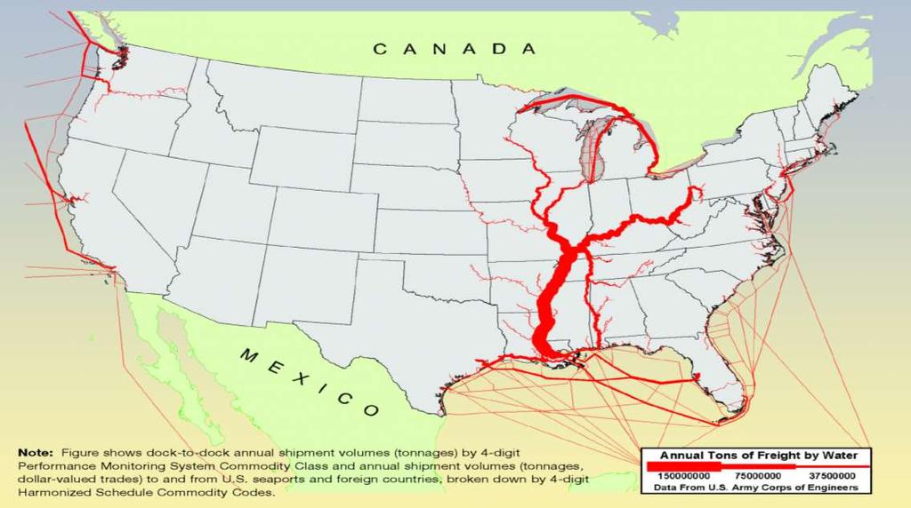
6 DEEP-DRAFT VESSEL MOVEMENTS ON THE MISSISSIPPI RIVER SHIP CHANNEL Approximately 7,500 ships entered and then exited Southwest Pass the last three years, each requiring either a State or Federal Pilot. Lower Mississippi River Deep-Draft Ports Complex: Baton Rouge, South Louisiana, New Orleans, St. Bernard and Plaquemines. Combined these five port move approximately 500 million tons of cargo every year. The LMR Deep-Draft Ports Complex is connected by nearly 256 miles of the Mississippi River Ship Channel.

7 VESSEL TYPES TRANSITING MISSISSIPPI RIVER SHIP CHANNEL

8 VIEW OF AFROMAX TANKER FROM NEW AGE SHIP

9 VIEW OF SWP CHANNEL FROM POST PANAMAX VESSEL
10 HISTORIC OPENINGS OF THE BONNET CARRE SPILLWAY Year Days Bays Opened
11 16.5 FEET 3/12/19

12 R.S WEEKS 2019 STARTS OFF IN BLUR
13
14
15 Corps MISSISSIPPI VALLEY NEW ORLEANS Operations and Maintenance Budget YEAR PRESIDENT'S BUDGET REQUEST Conference or WORK PLAN SUPPLEMENTAL REPRORGRAM TOTAL FUNDED 2019 $89,169,000 $58,660,000 $147,829, $83,846,000 $15,000,000 $75,000,000 $173,846, $82,884,900 $20,250,000 $10,000,000 $113,134, $85,866,000 $40,000,000 $33,364,507 $159,230, $85,341,000 $10,000,00 $5,020,080 $100,361, $84,074,000 $11,000,000 $95,074, $81,670,000 [$73,339,660] $73,339, $68,000,000 [$66,664,000] $84,000,000 $6,000,000 $156,664,000 AVERAGE $82,606,363 $127,434,905
16 MISSISSIPPI RIVER SHIP CHANNEL DRAFT RESTRICTIONS 2019/ DATES MAXIMUM DRAFT RECOMMENDATION JANUARY 31, 2019 FEBRUARY 8, 2019 FEBRUARY 8, 2019 FEBRUARY 8, 2019 REDUCED TO 44 FEET REDUCED TO 40 FEET INCREASED TO 41 FEET INCREASED TO 44 FEET 2018 DATES MAXIMUM DRAFT RECOMMENDATION MARCH 19, 2018 APRIL 7, 2018 APRIL 26, 2018 MAY 30, 2018 JUNE 6, 2018 JUNE 9, 2018 REDUCED TO 44 FEET REDUCED TO 42 FEET INCREASED TO 44 FEET INCREASED TO 45 FEET INCREASED TO 46 FEET INCREASED TO 47 FEET
17 MISSISSIPPI RIVER SHIP CHANNEL HOPPER DREDGES HOPPER DREDGES HOPPER CAPACITY CUBIC YARDS ELLIS ISLAND (2017)* 15,500 CHARLESTON, SC GLENN EDWARDS 13,500 SOUTHWEST PASS PRESENT LOCATION STUYVESANT 9,400 KINGS BAY, FL [Coming Soon Southwest Pass] MAGDALEN (2017)* 8,550 MANASQUAN, NJ *WHEELER (USACE) 8,256 SOUTHWEST PASS Red Flag LIBERY ISLAND 6,540 CHARLESTON, SC *ESSAYONS (USACE) 6,423 MAINTENANCE WEST COAST TERRAPIN ISLAND 6,400 SOUTHWEST PASS BAYPORT 4,855 KINGS BAY, FL B.E. LINDHOLM 4,000 JUPITER, FL NEWPORT 4,000 SOUTHWEST PASS R.N. WEEKS 4,000 MANASQUAN, NJ DODGE ISLAND 3,600 BRUNSWICK, GA PADRE ISLAND 3,600 BRUNSWICK, GA *McFARLAND (USACE) 3,000 SOUTHWEST PASS Red Flag

18 M/T ADVANTAGE START 156,639 DWT, 899 X Depth
19 MISSISSIPPI RIVER SHIP CHANNEL DEEPENING TO 50 FEET By deepening 65 miles of the Mississippi River Ship Channel to 50 feet, a total of 254 miles of the waterway will be connected at a depth of 50 feet or more. The majority of the Ship Channel is naturally deeper than 50 feet (Baton Rouge to the Gulf of Mexico). The first phase of the deepening to 50 feet will utilize dredges to deepen 33 river miles between the Gulf of Mexico and Venice (LA) and connect the first 176 miles of the Ship Channel to a depth of 50 feet or more. Phase two requires the deepening of approximately 32 river miles to add over 78 miles of Ship Channel at50 feet.
20 M/V OLYMPIC HARMONY 182,644 DWT 1,093 X DRAFT
21 MISSISSIPPI RIVER SHIP CHANNEL DEEPENING TO 50 FEET BIG RIVER COALITION IDENTIFIES STEPS NEEDED TO DEEPEN MISSISSIPPI RIVER SHIP CHANNEL 1) The channel threshold for full federal funding must be increased from 45 feet to 50 feet. COMPLETED: Water Resources Reform and Development Act of 2014 (WRRDA 2014). 2) General Reevaluation Report to update the economic impact of deepening the Mississippi River Ship Channel to 50 feet must be funded and completed by USACE and LDOTD. COMPLETED: Director s Report signed August 3, ) Fund and deepen the Mississippi River Ship Channel, the WRDA 2016 changed the cost-share from 50-50% between the federal government and the non-federal sponsor was changed to 75-25% (federal and non-federal) and the Water Infrastructure Improvements for the Nation Act (WIIN).
22 MISSISSIPPI RIVER SHIP CHANNEL DEEPENING COSTS 1) The estimated total for dredging from Venice to the Gulf of Mexico (Southwest Pass +) is approximately $110 million. From approximately Mile 10 Above Head of Passes (AHP) to Mile 22 Below Head of Passes. The Federal cost-share at 75% is $82.5 million and the non-federal cost-share at 25% is $ 27.5 million. The State of LA indicates it is prepared to fund its portion of this phase. This phase must be completed first and would open up 176 miles of the Ship Channel to a controlling depth of 50 feet. TOTAL: $110 million 2) The next phase of dredging will be on the Crossings Above New Orleans, from approximately Mile 154 AHP to Mile AHP is estimated to cost $47.5 million. The Federal cost-share at 75% is $ million and the non-federal cost-share at 25% is $ million. TOTAL: $47.5 million 3) there are up to six utility pipelines that might need to be relocated or deepened sufficiently below the mudline after channel deepening. The price tag for all pipelines to be deepened is estimated to be $80.2 million. TOTAL: $80.2 million 4) Dredging Costs: Southwest Pass: $110 million Crossings: $47.5 million TOTAL: $ million Pipeline Relocation: Non-federal: $40.1 million Pipeline owners: $40.1 million TOTAL: $ 80.2 million TOTAL PROJECT COSTS: $237,700,000
23 MISSISSIPPI RIVER SHIP CHANNEL (MRSC)DEEPENING TO 50 FEET The Soy Transportation Coalition and Informa Economics, Inc. estimate the larger, more efficient Capesize vessels (120,000 metric tons) ships, could reduce the cost of the movement of grains by upwards of $20 per metric ton due to being able to transport more soy cargo per vessel. The per bushel costs savings ranged from 13 to 20 cents depending on the proximity to a navigable waterway (barge fleeting). The same study identified a draw area, a metric related to the distance from the Mississippi River and Tributaries to the point of waterborne or barge commerce being cheaper than truck or rail shipments, the existing draw area is 150 miles. The draw area is projected to increase to 247 miles and could capture up to 82 percent of U.S. soybean exports. The economic update also repeated an idea that was first referenced by the Big River Coalition: Improving the depth of the Mississippi River would improve reliability of navigation on the river and reduce the impact of the occasional low water events.
24 SELECTED PLAN 50 FEET CHANNEL DEPTH The Selected Plan was adjusted based on the disparity between the 1-dimenisonal sediment modeling and the 2-dimensional sediment modeling. The 1-dimensional modeling over estimated the amount of sediment that would have to be removed, acknowledging this, led the Corps to suggesting the following deepening plan: Recommended deepening the Mississippi River Ship Channel below Venice (Mile 13.4 AHP to Mile 22 BHP) to 50 feet Mean Lower Low Water (MLLW) and deepening the Ship Channel up to Baton Rouge (Mile AHP) to 50 feet Low Water Reference Plane (LWRP). Investment Cost Total Cost $ 237,670,000 Federal Cost $ 118,130,000 Non-Federal Cost $ 119,540,000 ($39,380,000) Benefit Cost Ratio 7.2

25 LARGEST WETLANDS RESTORATION PROJECT IN THE WORLD
26 MISSISSIPPI RIVER SHIP CHANNEL FUNDING REQUESTS FY ) Approve Federal Funding for Deepening the MRSC to 50 Feet. 2)Approve $60 Million in Supplemental Funding for O&M to restore authorized channel dimensions on the MRSC in FY ) Support increasing NOAA PORTS Funding by $10 million to fund all U.S. PORTS Sensors. The Big River Coalition is committed to ensuring the future of navigation on the Mississippi River Ship Channel (MRSC) as one of the nation s fundamental natural resources and true economic powerhouse. The Mississippi River and Tributaries has an estimated annual impact of $735 billion on the nation s economy and is responsible for 2.4 million jobs (585,000 jobs on the Lower River Cairo, IL to the Gulf of Mexico and 1.86 million plus jobs on the Upper River-Lake Itasca, MN to Cairo, IL when including the IL River).
27 SEDIMENT RECYCLING

28 QUESTIONS?
BIG RIVER COALITION Advocating for a Mightier Mississippi River NATIONAL WATERWAYS CONFERENCE 91318
 BIG RIVER COALITION Advocating for a Mightier Mississippi River NATIONAL WATERWAYS CONFERENCE 91318 Sean M. Duffy, Sr. Executive Director sean.duffy@bigrivercoaltiio n.org MARITIME NATION ENGINEER S WEEK
U.S. Army Corps of Engineers Navigation Fiscal Overview
 U.S. Army Corps of Engineers Navigation Fiscal Overview National Dredging Meeting Jeffrey A. McKee Chief, Navigation Branch US Army Corps of Engineers June 24-26, 2014 US Army Corps of Engineers 1 Corps
Innovative Technologies for a Resilient Marine Transportation System
 Innovative Technologies for a Resilient Marine Transportation System Transportation Research Board MG John Peabody, P.E. Deputy Commanding General for Civil and Emergency Operations, U.S. Army Corps of
Canal traffic performance Grain cargo through the Panama Canal Panama Canal Expansion program Conclusion
 Canal traffic performance Grain cargo through the Panama Canal Panama Canal Expansion program Conclusion Canal began commercial operation 24/7 operation began Torrijos Carter & Neutrality Treaties Legal
Canal Traffic performance Grain cargo through the Panama Canal Panama Canal Expansion program Conclusion
 July 30-31, 2013 Canal Traffic performance Grain cargo through the Panama Canal Panama Canal Expansion program Conclusion Canal began commercial operation 24/7 operation began Torrijos Carter & Neutrality
State of Texas Operations and Maintenance
 State of Texas Operations and Maintenance Barbour Terminal Ship Channel The Barbour Terminal Channel and Turning Basin is a 1.7-mile-long deep draft waterway that extends from the Houston Ship Channel
The Port of Virginia and Economic Development
 The Port of Virginia and Economic Development RODNEY W. OLIVER, CHIEF FINANCIAL OFFICER VIRGINIA PORT AUTHORITY 1 EAST COAST / WEST TRADE BALANCE 2 AN IMPORT PARADIGM SHIFT The West Coast has traditionally
Lecture 1 Why Do We Have Levees in Louisiana? J. David Rogers, Ph.D., P.E., R.G.
 Lecture 1 Why Do We Have Levees in Louisiana? J. David Rogers, Ph.D., P.E., R.G. Karl F. Hasselmann Chair in Geological Engineering Missouri University of Science & Technology for the First Annual Levee
APPENDIX M DREDGED MATERIAL MANAGEMENT PLAN (DMMP) FINAL INTEGRATED FEASIBILITY REPORT AND ENVIRONMENTAL ASSESSMENT
 FINAL INTEGRATED FEASIBILITY REPORT AND ENVIRONMENTAL ASSESSMENT") APPENDIX M DREDGED MATERIAL MANAGEMENT PLAN (DMMP) Brazos Island Harbor, Texas Channel Improvement Study FINAL INTEGRATED FEASIBILITY REPORT AND ENVIRONMENTAL ASSESSMENT This page is intentionally left
APPENDIX M DREDGED MATERIAL MANAGEMENT PLAN (DMMP) Brazos Island Harbor, Texas Channel Improvement Study FINAL INTEGRATED FEASIBILITY REPORT AND ENVIRONMENTAL ASSESSMENT This page is intentionally left
2.6 Dry Bulk, Break-Bulk, and Yachts and Vehicles Cargo Market Assessment
 2.6 Dry, Break-, and Yachts and Vehicles Cargo Market Assessment 2.6.1 Forecast Summary Annual cargo demand for dry bulk, break-bulk, yachts and vehicles was forecast under three scenarios (see Figure
KANISA RUNGJANG UW - Madison
 Port cost comparisons and productivity from public funding: Port of Milwaukee and Port of Green Bay KANISA RUNGJANG UW - Madison National Center for Freight & Infrastructure Research & Education Port cost
ST. LOUIS SECTION PROJECT OF THE YEAR AWARD
 ST. LOUIS SECTION PROJECT OF THE YEAR AWARD Originality and Innovation The St. Louis Harbor Project is located in the Upper Mississippi River between the entrance to the Chain of Rocks Canal at River
Condition of Improvements 30 December 2014 Wrangell Harbors, Alaska (CWIS No , )
") Wrangell Harbors Condition of Improvements 30 December 2014 Wrangell Harbors, Alaska (CWIS No. 010435, 021500) Authorization (1) Rivers and Harbors Act, 22 September 1922 (House Doc. 161, 67th Congress,
Wrangell Harbors Condition of Improvements 30 December 2014 Wrangell Harbors, Alaska (CWIS No. 010435, 021500) Authorization (1) Rivers and Harbors Act, 22 September 1922 (House Doc. 161, 67th Congress,
Final Waterborne Commerce Statistics
 Final Waterborne Commerce Statistics For Calendar Year 16 Waterborne Commerce National Totals And Selected Inland Waterways For Multiple Years Institute for Water Resources Navigation and Civil Works Decision
(Refer Slide Time: 0:25)
") Port and Harbour Structures Prof. R. Sundaravadivelu Department of Ocean Engineering Indian Institute of Technology Madras Module 01 Lecture 04 Ships and Size of Ships So in this class we will continue
Port and Harbour Structures Prof. R. Sundaravadivelu Department of Ocean Engineering Indian Institute of Technology Madras Module 01 Lecture 04 Ships and Size of Ships So in this class we will continue
Grays Harbor O&M and Deepening Dredging
 Grays Harbor O&M and Deepening Dredging Elizabeth Chien Project Manager Seattle District 28 January 2016 US Army Corps of Engineers Grays Harbor Navigation Channel Inner Harbor O&M Dredging Summer 2015:
30 DAY PUBLIC NOTICE MAINTENANCE DREDGING OF THE 8-FOOT CHANNEL OF THE FEDERAL NAVIGATION PROJECT IN KENNEBUNK RIVER KENNEBUNK & KENNEBUNKPORT, ME
 fr.iiif.i ~ US Anny Corps of Engineers New England District 696 Virginia Road Concord, MA 01742-2751 Public Notice In Reply Refer to: Mr. Jack Karalius nae-pn-nav@usace.army.mil Programs/Project Management
A Single-Point Mooring System for Direct Pumpout of Hopper Dredges
 ..-0. -..- DRP-3-08 November 1992 Dredging Technical Research Notes A Single-Point Mooring System for Direct Pumpout of Hopper Dredges Purpose This technical note describes a direct pumpout (DPO) system
3.9 Marine Transportation
 3.9 Marine Transportation 3. Affected Environment and Environmental Analysis 3.9 Marine Transportation 3.9.1 Introduction This section describes existing marine vessel transportation within the Port, the
Vessel Traffic Service Lower Mississippi River
 Vessel Traffic Service Lower Mississippi River User Manual Third Edition 2013 Available for self printing at: http://homeport.uscg.mil TABLE OF CONTENTS INTRODUCTION... 1 GENERAL INFORMATION... 1 DEFINITIONS...
Coastal Harbors and Waterways, NC (Shallow Draft Navigation) (O&M)
 (O&M)") Coastal Harbors and Waterways, NC (Shallow Draft Navigation) (O&M) Shallow draft coastal harbors include a subsistence harbor at Silver Lake CONGRESSIONAL DISTRICT: NC 3 and 7 DATE: 23 February 2015 1.
Coastal Harbors and Waterways, NC (Shallow Draft Navigation) (O&M) Shallow draft coastal harbors include a subsistence harbor at Silver Lake CONGRESSIONAL DISTRICT: NC 3 and 7 DATE: 23 February 2015 1.
Texas Department of Transportation s Gulf Intracoastal Waterway Capacity Study. GICA 112 th Annual Seminar July 28, 2017
 Texas Department of Transportation s Gulf Intracoastal Waterway Capacity Study GICA 112 th Annual Seminar July 28, 2017 Study Purpose Determine if current levels of vessel activity on the Texas segment
Pacific Ocean Division. Navigation Program Overview. Association of Pacific Ports 2016 Winter Conference Waikaloa, Hawaii.
 Pacific Ocean Division Navigation Program Overview Association of Pacific Ports 2016 Winter Conference Waikaloa, Hawaii David Lau Pacific Ocean Division Chief, Civil Works Integration Division January
ASSOCIATED BRANCH PILOTS OF THE PORT OF NEW ORLEANS. TARIFF Effective January 1, 2018
 ASSOCIATED BRANCH PILOTS OF THE PORT OF NEW ORLEANS TARIFF Effective January 1, 2018 The said Associated Branch Pilots of the Port of New Orleans ( Bar Pilots ) shall be entitled to ask and receive the
Bridge Design for Marine Vessel Collision
 Bridge Design for Marine Vessel Collision Zolan Prucz, Ph.D., P.E. Modjeski and Masters, Inc. 2007 Louisiana Transportation Engineering Conference Baton Rouge, Louisiana Factors Involved Historical Developments
The economic significance of the Gulf of Mexico related to population, income, employment, minerals, fisheries and shipping
 MPRA Munich Personal RePEc Archive The economic significance of the Gulf of Mexico related to population, income, employment, minerals, fisheries and shipping Emilio Hernandez-Hernandez and Charles Adams
TITLE: The Importance of Model Validation: Two Case Studies. AUTHOR:Julie Thomas. Scripps Institution of Oceanography, La Jolla, CA.
 TITLE: The Importance of Model Validation: Two Case Studies AUTHOR:Julie Thomas Scripps Institution of Oceanography, La Jolla, CA jothomas@ucsd.edu CO-AUTHOR: Corey Olfe Scripps Institution of Oceanography,
(Refer Slide Time: 00:32)
") Port and Harbour Structures By Prof R. Sundaravadivelu Department of Ocean Engineering, Indian Institute of Technology Madras Module 8, Lecture 43 Detailed Project Report So last class we discussed about
Port and Harbour Structures By Prof R. Sundaravadivelu Department of Ocean Engineering, Indian Institute of Technology Madras Module 8, Lecture 43 Detailed Project Report So last class we discussed about
Cordova Harbor Page 2 of 9
 Cordova Harbor Cordova Harbor Page 2 of 9 Condition of Improvements 30 December 2017 Cordova Harbor, Alaska (CWIS No. 087136, 087186, 087711) Authorization Rivers and Harbors Act, 30 August 1935 (R & H
Grays Harbor Federal Project
 Grays Harbor Federal Project Elizabeth Chien Coastal Navigation Program Manager Seattle District 27 October 2016 US Army Corps of Engineers Grays Harbor Navigation Channel Inner Harbor Dredging Summer
1-32 NOME HARBOR, ALASKA (CWIS NOS , 87755, & 10422) Condition of Improvement 30 September 2009
 Condition of Improvement 30 September 2009") NOME HARBOR 1-32 NOME HARBOR, ALASKA (CWIS NOS. 72742, 87755, & 10422) Condition of Improvement 30 September 2009 AUTHORIZATION: (1) Rivers and Harbors Act, 8 August 1917 (House Doc. 1932, 64th Congress,
NOME HARBOR 1-32 NOME HARBOR, ALASKA (CWIS NOS. 72742, 87755, & 10422) Condition of Improvement 30 September 2009 AUTHORIZATION: (1) Rivers and Harbors Act, 8 August 1917 (House Doc. 1932, 64th Congress,
ADANI PORTS & SEZ LTD. ++ MUNDRA PORT ++ GENERAL INFORMATION
 ADANI PORTS & SEZ LTD. ++ MUNDRA PORT ++ GENERAL INFORMATION LOCATION Mundra Port is all weather, independent, commercial port with geographical and hydrological advantages on the West Coast of India,
Planning Considerations for Nearshore Placement of Mixed Dredged Sediments
 Planning Considerations for Nearshore Placement of Mixed Dredged Sediments PURPOSE: Dredging planning and management decisions are based on a combination of engineering and economic factors tempered by
1-32 NOME HARBOR, ALASKA (CWIS NOS , 87755, 12270, & 10422) Condition of Improvement 30 September 2012
 Condition of Improvement 30 September 2012") NOME HARBOR 1-32 NOME HARBOR, ALASKA (CWIS NOS. 72742, 87755, 12270, & 10422) Condition of Improvement 30 September 2012 AUTHORIZATION: (1) Rivers and Harbors Act, 8 August 1917 (House Doc. 1932, 64th
NOME HARBOR 1-32 NOME HARBOR, ALASKA (CWIS NOS. 72742, 87755, 12270, & 10422) Condition of Improvement 30 September 2012 AUTHORIZATION: (1) Rivers and Harbors Act, 8 August 1917 (House Doc. 1932, 64th
MOREHEAD CITY HARBOR, NC. Dredged Material Management Plan (DMMP)
") MOREHEAD CITY HARBOR, NC Dredged Material Management Plan (DMMP) Public Meeting/Info Session 15 January 2014 US Army Corps of Engineers Morehead City Harbor DMMP Presentation Topics Morehead City Harbor
MOREHEAD CITY HARBOR, NC Dredged Material Management Plan (DMMP) Public Meeting/Info Session 15 January 2014 US Army Corps of Engineers Morehead City Harbor DMMP Presentation Topics Morehead City Harbor
World exports as a share of GDP
 World exports as a share of GDP 35% 30% 25% 20% 15% 1991 1993 1995 1997 1999 2001 2003 2005 2007 2009 Source: WTO, World Bank. World goods and service exports US$ trillions Commercial services (L) Total
Coastal Harbors and Waterways, NC (Shallow Draft Navigation) (O&M)
 (O&M)") Coastal Harbors and Waterways, NC (Shallow Draft Navigation) (O&M) Shallow draft coastal harbors include a subsistence harbor at Silver Lake CONGRESSIONAL DISTRICT: NC 3 and 7 DATE: 23 February 2015 1.
Coastal Harbors and Waterways, NC (Shallow Draft Navigation) (O&M) Shallow draft coastal harbors include a subsistence harbor at Silver Lake CONGRESSIONAL DISTRICT: NC 3 and 7 DATE: 23 February 2015 1.
Humboldt Bay s Harbor
 Humboldt Bay s Harbor Humboldt Bay is the second largest natural bay in California The only deep water harbor along ~400 miles of coast between San Francisco, CA and Coos Bay, OR One of only 11 deep water
Unalaska Navigation Channel Improvements
 1 237 237 237 255 255 255 0 0 0 Unalaska Navigation Channel Improvements 217 217 217 200 200 200 163 163 163 131 132 122 239 65 53 80 119 27 252 174.59 110 135 120 112 92 56 62 102 130 102 56 48 130 120
Intracoastal Waterway and other Federal Shallow Draft Inlets
 Intracoastal Waterway and other Federal Shallow Draft Inlets Shelley Trulock Project Manager 904-232-3292 Navigation 900 miles of Inland Waterways 6 navigation locks Atlantic Intracoastal Waterway (AIWW)
DRAFT. October 17, 2014 File No Mr. Brendhan Zubricki Town Administrator Essex Town Hall 30 Martin Street Essex, MA.
 GZA GeoEnvironmental, Inc. Engineers and Scientists October 17, 2014 File No. 18.0171857.00 Mr. Brendhan Zubricki Town Administrator Essex Town Hall 30 Martin Street Essex, MA. 01929 DRAFT Re: Essex River
State Pilotage A Critical Component of a Resilient Marine Transportation System
 State Pilotage A Critical Component of a Resilient Marine Transportation System Clay Diamond Transportation Research Board June 25, 2014 1 Outline Dependability is Key to a Resilient MTS * Safe * Reliable
Inland Marine Transportation System
 Inland Marine Transportation System Capital Investment Strategy Jeanine Hoey, PE, PMP Program Manager 15 December 2009 US Army Corps of Engineers 1 Inland Marine Transportation System (IMTS) Capital Investment
Norwalk Harbor: The Jewel of Long Island Sound. A Presentation by the Norwalk Harbor Management Commission
 Norwalk Harbor: The Jewel of Long Island Sound A Presentation by the Norwalk Harbor Management Commission 2018 State of the Harbor Meeting December 13, 2018 The City of Norwalk in Southwest Connecticut
FY-16 Ongoing Contracts FY-16 Scheduled Contracts
 FY-16 Ongoing Contracts FY-16 Scheduled Contracts Christopher Frabotta Deputy Chief, Operations Division / Chief, Navigation Branch Southwestern Division - Galveston District 8 October 2015 Galveston District
Coastal Harbors and Waterways, NC (Shallow Draft Navigation) (O&M)
 (O&M)") Coastal Harbors and Waterways, NC (Shallow Draft Navigation) (O&M) Shallow draft coastal harbors include a subsistence harbor at Silver Lake CONGRESSIONAL DISTRICT: NC 3, 7 DATE: 23 April 2018 1. AUTHORIZATION:
Coastal Harbors and Waterways, NC (Shallow Draft Navigation) (O&M) Shallow draft coastal harbors include a subsistence harbor at Silver Lake CONGRESSIONAL DISTRICT: NC 3, 7 DATE: 23 April 2018 1. AUTHORIZATION:
Eelgrass and Macroalgae Presence/Absence Preliminary Surveys BHP Proposed Grays Harbor Potash Export Facility A Task 400
 Memorandum 40600-HS-MEM-55036 Revision 0 Date: 26 July 2018 Subject: Eelgrass and Macroalgae Presence/Absence Preliminary Surveys BHP Proposed Grays Harbor Potash Export Facility A17.0202.00 Task 400 INTRODUCTION
Real Property Institute of Canada Marine Infrastructure National Workshop. A new era in dredging for Eastern Canada
 Real Property Institute of Canada Marine Infrastructure National Workshop A new era in dredging for Eastern Canada Subjects covered Definition of dredging Main dredging activities Type of dredging and
Ecosystem Func-on and Value in the Columbia River Basin
 Ecosystem Func-on and Value in the Columbia River Basin David Batker, Johnny Mojica Earth Economics 10.19.16 Let s get the investment to restore salmon Rights are Preeminent Valua-on helps remove the
PNWA Conference Update
 PNWA Conference Update COLONEL Jose Aguilar District Commander Portland District 2 October, 2014 US Army Corps of Engineers Projects Mouth of the Columbia (MCR) Jetties Columbia River Status Coastal Dredging
With its rich heritage in Texas history, the U.S. Army Corps of Engineers
 UPDATE REPORT FOR THE STATE OF TEXAS Current as of May 2013 John Cornyn U.S. Senate State of Texas About the Galveston District With its rich heritage in Texas history, the U.S. Army Corps of Engineers
Juneau Douglas Harbor
 Juneau Douglas Harbor Douglas Harbor Page 2 of 8 Condition of Improvements 31 December 2015 Douglas Harbor, Alaska (CWIS No. 072789, 180942) Authorization Rivers and Harbors Act, 3 July 1958 (House Doc.
La Quinta Channel Extension Port of Corpus Christi Ingleside, Texas. Mark Coyle
 La Quinta Channel Extension Port of Corpus Christi Ingleside, Texas Mark Coyle Corpus Christi Navigation Channel PCCA La Quinta Expansion Project History Corpus Christi Ship Channel Improvement Projects
OPERATIONS Western Gulf Coast Edition TX DOT Ports & Waterways Conference 2009
 Click to edit Master title style 1 OPERATIONS Western Gulf Coast Edition TX DOT Ports & Waterways Conference 2009 Section 5 Click to edit Master title style 5.1 Towing 2 5.1 Towing Click to edit Master
The St. Lawrence Seaway--To Mid-Continent by Ocean Vessel
 Case Western Reserve Law Review Volume 11 Issue 1 1959 The St. Lawrence Seaway--To Mid-Continent by Ocean Vessel Lewis W. Britton Follow this and additional works at: http://scholarlycommons.law.case.edu/caselrev
USACE Civil Works Program: Challenges and Opportunities Planning Workshop
 USACE Civil Works Program: Challenges and Opportunities Planning Workshop MG John Peabody, P.E. Deputy Commanding General Civil and Emergency Operations U.S. Army Corps of Engineers 2 June, 2015 US Army
V. HARBOR DEPTHS, CHANNEL DESIGN AND PROPOSED CONSTRUCTION AND DREDGING
 V. HARBOR DEPTHS, CHANNEL DESIGN AND PROPOSED CONSTRUCTION AND DREDGING A. DISCUSSION: For the most part, projects that involve dredging and construction require a comprehensive design and review process
BENEFIT-COST ANALYSIS OF HARBOR DREDGING ON THE GREAT LAKES
 Middle States Geographer, 997,30:55-6 BENEFT-COST ANALYSS OF HARBOR DREDGNG ON THE GREAT LAKES Raymond W. Waxmonsk:y Department of Geography & Planning Buffalo State College Buffalo, NY 4222 ABSTRACT:
2017 Major Projects Pipeline Report Adrian Hart, Senior Manager Infrastructure & Mining
 2017 Major Projects Pipeline Report Adrian Hart, Senior Manager Infrastructure & Mining Major Projects Pipeline Report - 2017 Presentation Outline Key findings of the 2017 Pipeline Report The outlook for
U.S. and Ohio Midstream Infrastructure Development
 U.S. and Ohio Midstream Infrastructure Development Findings and Results from ICF s Study for American Petroleum Institute, April 2017, U.S. Oil and Gas Infrastructure Investment through 2035 An Engine
2013 FEDERAL STORM RESPONSE
 2013 FEDERAL STORM Presented to the Florida Shore & Beach Association Sep 26, 2013 Presented by: COL Alan Dodd Commander, Jacksonville District September 2013 THE COLLABORATION 2 THE PROGRAM 3 THE STORMS
Mouth of the Columbia River Jetties Three-Phase Construction Plan
 Mouth of the Columbia River Jetties Three-Phase Construction Plan Project Overview October 9, 2012 US Army Corps of Engineers MCR Jetties Major Rehabilitation Sand Island pile dikes 1930-1935 Columbia
FINAL ENVIRONMENTAL IMPACT STATEMENT ON BROWARD COUNTY SHORE PROTECTION PROJECT SEGMENTS II AND III BROWARD COUNTY, FLORIDA
 FINAL ENVIRONMENTAL IMPACT STATEMENT ON BROWARD COUNTY SHORE PROTECTION PROJECT SEGMENTS II AND III BROWARD COUNTY, FLORIDA 1. PROJECT PURPOSE AND NEED 1.1. PROJECT AUTHORITY. 1.1.1. INITIAL AUTHORIZATION.
U.S. Aids To Navigation System Brochure U.S. Coast Guard, Office of Aids to Navigation (202) ,
 ,") AIDS TO NAVIGATION Learning Objectives: As a result of this session the participant should: Understand the principal buoyage systems in the United States. Become aware of the characteristics of the buoy
AIDS TO NAVIGATION Learning Objectives: As a result of this session the participant should: Understand the principal buoyage systems in the United States. Become aware of the characteristics of the buoy
Use of AIS and AISAP for Analysis of Vessel Wakes in Charleston Harbor: A Case Study
 Use of AIS and AISAP for Analysis of Vessel Wakes in Charleston Harbor: A Case Study by Brandan Scully and Anne McCartney PURPOSE: This Coastal and Hydraulics Engineering Technical Note (CHETN) describes
EVALUATION OF BEACH EROSION UP-DRIFT OF TIDAL INLETS IN SOUTHWEST AND CENTRAL FLORIDA, USA. Mohamed A. Dabees 1 and Brett D.
 EVALUATION OF BEACH EROSION UP-DRIFT OF TIDAL INLETS IN SOUTHWEST AND CENTRAL FLORIDA, USA Mohamed A. Dabees 1 and Brett D. Moore 1 The paper discusses the analysis of up-drift beach erosion near selected
An Example of a Unique Partnership for Contaminated Sediment Management The Port Hueneme Experience
 An Example of a Unique Partnership for Contaminated Sediment Management The Port Hueneme Experience AAPA/USACE Quality Partnership Initiative 4 th Annual Project Managers Workshop Port of Ponce, Puerto
Commercial Marine Activity for Deep Sea Ports in the United States. Final Report. United States Environmental Protection Agency.
 United States Environmental Protection Agency Air and Radiation EPA420-R-99-020 September 1999 Commercial Marine Activity for Deep Sea Ports in the United States Final Report Printed on Recycled Paper
Analysis of Great Lakes Pilotage Costs on Great Lakes Shipping and the Potential Impact of Increases in U.S. Pilotage Charges
 Analysis of Great Lakes Pilotage Costs on Great Lakes Shipping and the Potential Impact of Increases in U.S. Pilotage Charges Prepared for: United States Coast Guard 2703 Martin Luther King Jr Ave SE Washington,
Caloosahatchee River Citizen s Association
 Caloosahatchee River Citizen s Association www.caloosahatchee.org Autumn 2002 Caloosahatchee Regional Park Plan Revised! Public Participation Pays off! Last fall the Lee County Parks & Recreation Department
World Trade Services Outlook
 World Trade Services Outlook Copyright 2005 Global Insight, Inc. Paul Bingham Global Insight, Inc. October 26, 2006 Macro View of Trade Confirms Globalization s Long-term Impact on the U.S. Economy 18
2018 Annual Economic Forecast Dragas Center for Economic Analysis and Policy
 2018 Annual Economic Forecast Dragas Center for Economic Analysis and Policy PRESENTING SPONSOR EVENT PARTNERS 2 The forecasts and commentary do not constitute an official viewpoint of Old Dominion University,
Northwestern Division COMMAND BRIEF
 Northwestern Division COMMAND BRIEF Colonel William Leady Deputy Commander Northwestern Division 2015 US Army Corps of Engineers USACE Mission Areas BUILDING STRONG USACE Supports the Army and the Nation
3.9 Marine Transportation
 3.9 Marine Transportation 3. Affected Environment and Environmental Analysis 3.9 Marine Transportation 3.9.1 Introduction This section describes existing marine vessel transportation within the Port, the
Nome Harbor Page 2 of 12
 Nome Harbor Nome Harbor Page 2 of 12 Condition of Improvements 30 December 2015 Nome Harbor, Alaska (CWIS No. 010422, 012270, 072742, 087755) Authorization (1) Rivers and Harbors Act, 8 August 1917 (House
Update on the 2017 Atlantic Menhaden Fishing Season
 Update on the 2017 Atlantic Menhaden Fishing Season Sustainable Fisheries Branch NMFS Beaufort Laboratory Beaufort, NC GSMFC Spring Meeting Panama City, FL March 13, 2018 2017 Landings for Reduction One
Regional Sediment Management Opportunities within Intracoastal Waterway (IWW) Dredging Program in the State of Florida
 Dredging Program in the State of Florida") Regional Sediment Management Opportunities within Intracoastal Waterway (IWW) Dredging Program in the State of Florida INTRODUCTION: The topic of this Regional Sediment Management (RSM) Technical Note
Regional Sediment Management Opportunities within Intracoastal Waterway (IWW) Dredging Program in the State of Florida INTRODUCTION: The topic of this Regional Sediment Management (RSM) Technical Note
MEAN LOW TIDE (MLT) to MEAN LOWER LOW WATER (MLLW)
 to MEAN LOWER LOW WATER (MLLW)") MEAN LOW TIDE (MLT) to MEAN LOWER LOW WATER (MLLW) WEDA GULF COAST CHAPTER ANNUAL CONFERENCE Christopher Frabotta Deputy Chief, Operations Division Galveston District Southwestern Division November 16,
MEAN LOW TIDE (MLT) to MEAN LOWER LOW WATER (MLLW) WEDA GULF COAST CHAPTER ANNUAL CONFERENCE Christopher Frabotta Deputy Chief, Operations Division Galveston District Southwestern Division November 16,
Oklahoma s Inland Waterway: The McClellan-Kerr Arkansas River Navigation System
 Oklahoma s Inland Waterway: The McClellan-Kerr Arkansas River Navigation System Objective Students will read about river navigation and transportation of agricultural products by barge. Students will compare
Transportation Day at the Capitol. Charlie Zelle Commissioner, MnDOT Feb. 16, 2017
 Transportation Day at the Capitol Charlie Zelle Commissioner, MnDOT Feb. 16, 2017 State Transportation System Highways 59.1 billion annual vehicle miles traveled 33.1 billion on trunk highways Bridges
Maltester Channel Dredging. Shoreline Marina Committee. November 18, 2008
 Maltester Channel Dredging Shoreline Marina Committee November 18, 2008 Shoaling Study Summary Report Completed in October 2008 Analyzed siltation rates at Marina Rate of siltation is dynamic ranging from
CORPS ON THE COAST. North Carolina Coastal Conference Coastal Infrastructure Raleigh, NC April 14, Jim Medlock Chief, Programs Management Branch
 CORPS ON THE COAST North Carolina Coastal Conference Coastal Infrastructure Raleigh, NC April 14, 2015 Jim Medlock Chief, Programs Management Branch US Army Corps of Engineers OVERVIEW What Are The Corps
State of American Trucking
 State of American Trucking October 11, 2018 Rod Suarez Economic Analyst American Trucking Associations rsuarez@trucking.org Business Cycles U.S. Expansions Duration October 1949 - July 1953 May 1954 -
MILE POINT TRAINING WALL JACKSONVILLE, FL. Geotextile Tube Installation
 MILE POINT TRAINING WALL JACKSONVILLE, FL Geotextile Tube Installation PROJECT DESIGN Remove portion of existing training wall Construct new eastern and western training walls Deepen new flow improvement
FREIGHT DYNAMICS IN THE LOW PRICE CLIMATE METAL BULLETIN INTERNATIONAL IRON ORE SYMPOSIUM
 FREIGHT DYNAMICS IN THE LOW PRICE CLIMATE METAL BULLETIN INTERNATIONAL IRON ORE SYMPOSIUM JUNE 216 PRESENTATION STRUCTURE year-to-date freight market in perspective 1q16 sees vessel earnings sink to historic
Delaware River Vessel Reporting System Mariners Advisory Committee For
 Delaware River Vessel Reporting System Mariners Advisory Committee For the Bay and River Delaware The Mariner's Advisory Committee is comprised of Master Mariners, River Pilots, and concerns itself with
PLAQUEMINES PARISH BARRIER ISLAND RESTORATION & SUSTAINABILITY. MVD/Gulf Coast Regional Dredging Meeting November 5, 2013
 PLAQUEMINES PARISH BARRIER ISLAND RESTORATION & SUSTAINABILITY MVD/Gulf Coast Regional Dredging Meeting November 5, 2013 OVERVIEW 1. Barrier Island Restoration Projects in Plaquemines Parish 2. Plaquemines
NITC Outlook On Middle East Oil Movement & Tanker Shipping
 NITC Outlook On Middle East Oil Movement & Tanker Shipping Presented by: Mohammad Souri Chairman & CEO, NITC Intertanko s Annual Event Istanbul, 20-23 April 2008 1 Country Oil Proven Reserve Billion Barrel
Innovation in an Interconnected World
 Innovation in an Interconnected World Chairman s Address National Grain and Feed Association 119 th Annual Convention March 16, 2015 San Antonio, TX Welcome to San Antonio! 2 Million Metric Tons U.S. Grain
The economic value of the EU shipping industry. Andrew P Goodwin
 The economic value of the EU shipping industry Andrew P Goodwin 2 nd April 2014 Introduction Shipping is a vital facilitator of world trade 135 % Increase in world GDP in the last two decades 180 % Increase
SEDAR 63: Gulf Menhaden
 SEDAR 63: Gulf Menhaden Fishery Dependent Data Collection at the NMFS Beaufort Laboratory Ray Mroch NMFS Beaufort Laboratory SEDAR 63 Review Workshop November 6, 2018 Fishery-Dependent Data for the Gulf
GIAV & SFMCA VIC MEETING BLACK SEA PRESENTATION BY ADM
 1 GIAV & SFMCA VIC MEETING BLACK SEA PRESENTATION BY ADM Black Sea Ports 2 Black Sea vs Australia Snapshot 3 Population (million people) Total Land mil HA Arable Land mil HA Arable Land used for Cropping
Columbia River Navigation
 Columbia River Navigation HISTORY COMMITTEE Pat Brodin John Carpita Bob Moorhead Columbia River Navigation Columbia River Discovery & Exploration Columbia Bar Shipwrecks Graveyard of the Pacific Columbia
Louisiana CPRA SJB Group, Baton Rouge Coastal Engineering Consultants U.S. Army Corps of Engineers Federal and State PDT Members
 Louisiana CPRA SJB Group, Baton Rouge Coastal Engineering Consultants U.S. Army Corps of Engineers Federal and State PDT Members Project Setting and Background Island Restoration Plans Pre-Screening Analysis
Estimated on-the-ground start and end dates: 1 June October 2018
 A. Applicant Information Name of Organization: U.S. Army Corps of Engineers, Carlyle Lake 801 Lake Road, Carlyle, IL 62231 Contact Information: Robert Wilkins, Operations Manager, (618) 594-2484, Robert.Wilkins@usace.army.mil
C C S Technical Information
 C C S Technical Information (2014) Technical Information No.7 Total No.129 Jan.28,2014 (Total 3+5+1 pages) To: CCS Surveyors, Plan Approval Surveyors, Relevant Ship Companies, Shipyards and Design Institutes
Corn Outlook. February, 2018
 Corn Outlook February, 2018 Corn Outlook February 2018 Historical Price Reference Fundamental Backdrop Seasonal Tendency Summary 2 Historical Price Reference Where are Corn Prices Currently, And Where
2018 Annual Economic Forecast Dragas Center for Economic Analysis and Policy
 2018 Annual Economic Forecast Dragas Center for Economic Analysis and Policy PRESENTING SPONSOR EVENT PARTNERS 2 The forecasts and commentary do not constitute an official viewpoint of Old Dominion University,
Brief History of the Gulf Menhaden Purse-Seine Fishery. Ray Mroch NMFS Beaufort Laboratory
 Brief History of the Gulf Menhaden Purse-Seine Fishery Ray Mroch NMFS Beaufort Laboratory SEDAR 63 Review November 6, 2018 Scientific name: Brevoortia patronus (Family: Clupeidae) Distribution: from southwest
National Transportation Safety Board
 Accident no. Vessel names Accident type Location DCA15LM034 National Transportation Safety Board Marine Accident Brief Collision between Dewey R Tow and P. B. Shah Tow Dewey R tow and P. B. Shah tow Collision