West Burnside/Couch Green Streets
|
|
|
- Lindsey Hancock
- 5 years ago
- Views:
Transcription

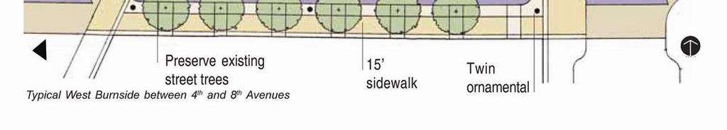
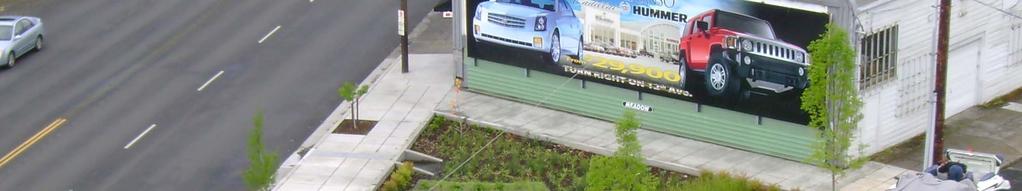
1 West Burnside/Couch Green Streets Portland Office of Transportation Bureau of Environmental Services Lloyd D. Lindley, ASLA Parametrix, Inc. Design Advisory Committee February 20, 2008

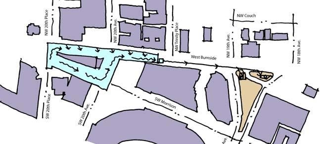
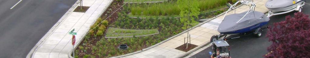
2 Overview I-405 North Park Blocks Washington Park PGE Park Upper Burnside Central Burnside/Couch Lower Burnside Washington Park 100-feet I-405 Willamette River Burnside drops over 100-feet between the west hills and 2 nd Avenue 2

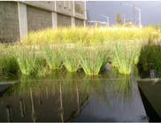
3 Systems Conveyance Collection Infiltration Disposal D. Elkin D. Elkin Washington Park An interconnected system of conveyance, collection, infiltration and disposal facilities from the west hills to the Willamette River. I-405 Willamette River 3


4 Burnside/Couch System Northwest Style Native and native-like plants Evergreen trees Expressive of water flow from Washington Park to the Willamette River Washington Park Create a landscape that expresses the Pacific Northwest and Portland s natural areas. Bring the green of Washington Park into the City. Bring the river s edge into the City. I-405 Willamette River 4


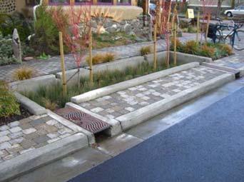
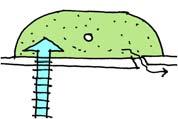
5 Tool Box Daisy chain gutter to planter Infiltration BES Plan of Egg at curb line D. Elkin Gravity fed aeration 5


")
6 Tool Box Planter Track drain and conveyance Slope Swale Track drain to swale Swale V W Sidewalk Planter IN OUT Flow IN OUT T. Lipton IN OUT IN OUT Planter Slope Slope Veggie-wing (V W) Planter Tree Planter BES 6


7 Form Alternatives Curvilinear Implies movement Emulates natural forms Complements human movement Rectilinear Conforms to the rectilinear form of the street grid Creates angular edges Efficiency 7


8 Form Alternatives Curvilinear Rectilinear Patterns Patterns Edges Edges 8
9 Concept Alternatives Curvilinear Rectilinear 9


10 Upper West Burnside NW 24 th Place NW 23 rd W 20 th Place NW 19 th Ave. NW 18 th Ave. NW 16 th Ave. System Plan Direction of flow Washington Park Streetcar Terminus Grass Track NW 23 rd W 20 th Place Water Organ Aeration System Section W 18 th /19 th Fireman s Memorial I

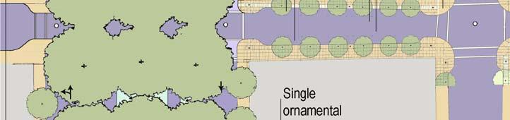
11 Upper West Burnside Terminal Station at 24 th Place Burnside Washington Park Exclusive guideway Grass Track Trail Park Road NW 24 th Place Memorial Uptown Shopping Center Surface Parking Stop Washington Park General Section Burnside Grass Track Switzerland D. Elkin Burnside looking south 11


12 Upper West Burnside Burnside at 23 rd and Vista Stop Planters Surface Parking V W Plan at Burnside and NW 23 rd /Vista Surface Parking Stop Surface Parking V W Surface Parking Typical Section Burnside and NW 23 rd /Vista Veggie-wing on both sides of Burnside 12


13 Upper West Burnside SW 21 st Avenue Close SW Morrison between SW 21st and SW 20th Place 20 th Place Triangle SW 20 th Place Add 4 on-street parking spaces Provide streetcar stops Preserve surface parking access Morrison 13


14 Upper West Burnside Watershed area for aeration at the 20 th Place triangle Simple aeration device in the Lloyd District 14

15 Upper West Burnside Surface Parking 20 th Place Triangle Surface Parking 3-Parking 1-Parking Plan of Triangle at NW 20 th Place and Burnside Typical Section Typical Section at a triangle with gravity fed aeration feature 15
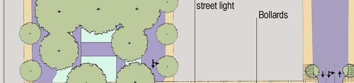
16 18 th and 19 th at the Fireman s Memorial SW 19 th Ave Upper West Burnside Burnside 4-onstreet parking Plan of 18 th /19 th at the Fireman s Memorial A SW 18 th Ave A The Island Typical partial section A-A at a triangle 16 with gravity fed aeration feature Evergreen trees reflect the Northwest and absorb CO2 year round

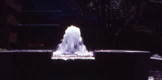
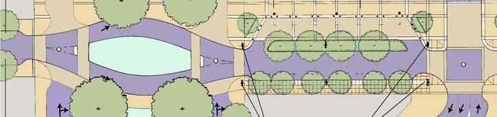
17 Upper West Burnside Fireman s Memorial Typical section A-A of the Island SW Alder The Island W Burnside The watershed for the 18 th /19 th aeration facility Ira Keller fountain The Source for Lovejoy and Ira Keller fountains 17
18 Upper West Burnside Discussion 18


19 Central Burnside NW 16 th Ave. NW 15 th Ave. NW 14 th Ave. NW 11 th Ave. NW 10 th Ave. North Park Blocks System Plan Direction of flow I-405 North Park Blocks 15 th / 16 th Triangle Stark Street 10 th Avenue Triangle System Section North Park Block Crossing 19


20 Central Burnside NW 16th Close Washington between W 16 th and 15th Place 15 th Avenue Triangle SW 15th Burnside Add 5 on-street parking spaces Provide streetcar stop 20


21 Central Burnside Typical Section at a triangle with gravity fed aeration feature Aeration facility in Seattle Watershed area for aeration at the 15 th Avenue triangle 21

22 Central Burnside 22
23 Central Couch 23

24 Central Couch 8.5-feet Planter Typical Section Egg 24


25 Central Burnside 10 th and Burnside Triangle 25
26 Central Burnside 26
27 Central Burnside Discussion 27


28 Lower Burnside North Park Blocks NW Broadway NW 6 th Ave. NW 5 th Ave. NW 4 th Ave. NW 3 rd Ave. NW 2 nd Ave. Couch Burnside System Plan Direction of flow North Park Blocks Willamette River Burnside Bridge Park Blocks Crossing Burnside Boulevard 2 nd Avenue System Section 28
29 Lower Burnside 29


30 Lower Burnside 30


31 Lower Couch 8.5-feet Curb extension alternative Typical V W Egg Egg Typical section Typical Curb extension 31

32 Lower Burnside 32


33 Lower Burnside Tool Bar 33
34 Lower Burnside Discussion 34

35 DISCUSSION & QUESTIONS 35
Bicycle and Pedestrian Advisory Committee (BPAC) November 21, 2013
 November 21, 2013") Bicycle and Pedestrian Advisory Committee (BPAC) November 21, 2013 OVERALL LAND USE CONCEPT Overall Broadway Valdez District: 95.5 acres (35.1 acres right-of ways + 60.4 acres developable land) Plan Subareas:
Bicycle and Pedestrian Advisory Committee (BPAC) November 21, 2013 OVERALL LAND USE CONCEPT Overall Broadway Valdez District: 95.5 acres (35.1 acres right-of ways + 60.4 acres developable land) Plan Subareas:
Brooklyn Boulevard (County Road 152) Reconstruction Project Phase I. OPEN HOUSE June 20, 2017
 Reconstruction Project Phase I. OPEN HOUSE June 20, 2017") Brooklyn Boulevard (County Road 152) Reconstruction Project Phase I OPEN HOUSE June 20, 2017 Brooklyn Boulevard (County Road 152) Phase I Project Partners Project Lead Other Project Partners include Brooklyn
Brooklyn Boulevard (County Road 152) Reconstruction Project Phase I OPEN HOUSE June 20, 2017 Brooklyn Boulevard (County Road 152) Phase I Project Partners Project Lead Other Project Partners include Brooklyn
Operations -- Transit From: N/A To: N/A. Improvement Type: Regionally Significant: No
 Central Puget Sound Regional 2017-2020 Transportation Improvement Program Amendments and Corrections to be included in the 2017-20 STIP PSRC's Amendment 2017-08 County: King List of 17-08 Amendment Projects:
Major Bike Routes 102 Avenue Workshop April 21, 2015
 Major Bike Routes 102 Avenue Workshop April 21, 2015 Our Purpose Today Provide context on how Major Bike Routes fit into Edmonton s future Share information on what we heard in our last phase, and how
Pedestrian and Bicycle Safety Program Leg Agency Title of Project Project Description Dist
 2015-17 and Bicycle Safety Program Leg Lummi Nation 42 Kennewick 8 Lummi Nation 42 Jamestown S'Klallam 24 WSDOT-- NW 32 Port of Vancouver 49 Spokane 3 Seattle 46 Shoreline 32 Lummi Shore Drive Columbia
3. INTERCONNECTED STREETS AND TRANSPORTATION NETWORKS
 Design Approaches 61 3. INTERCONNECTED STREETS AND TRANSPORTATION NETWORKS There are a number of different approaches to interconnect streets in neighborhoods and Development Areas. Interconnections provide
Seattle Bicycle Advisory Board August 3, 2011
 First Hill Streetcar Project Seattle Bicycle Advisory Board August 3, 2011 S teve Durrant Alta Planning + Des ign Mark Dorn UR S J im Peters DK S Context First Hill Cycle Track Key Strategies Segment 1
Right-of-Way Standards
 City of Ketchum P.O. Box 2315 480 East Ave. N. Ketchum, ID 83340 Right-of-Way Standards Effective July 2015 Introduction A public right-of-way is defined as improved or unimproved public property dedicated
Right-of-Way Standards
 City of Ketchum P.O. Box 2315 480 East Ave. N. Ketchum, ID 83340 Right-of-Way Standards Effective July 2015 Introduction A public right-of-way is defined as improved or unimproved public property dedicated
Bridges and Arizona Crossings
 Circulation and Transportation 5-11 Discovery Street/Barham Drive. Discovery Street is planned 5.4.3 Specific Plan Circulation Improvements to be extended eastward from its terminus at Craven Road Circulation
Schutte Park Master Plan February 14, 2017
 Schutte Park Master Plan February 14, 2017 Overview The Schutte Park Master Plan is a product of the City of Dover Recreation Needs Assessment. This primary planning document for all of the city parks
Annual Listing of Obligated MPO Projects
 Thurston Regional Planning Council Annual Listing of Obligated MPO Projects CY 2015 March, 2016 2424 Heritage Court SW, Suite A, Olympia, WA 98502 360.956.7575 www.trpc.org About TRPC, established in 1967,
5 CIRCULATION AND STREET DESIGN
 5 CIRCULATION AND STREET DESIGN This chapter describes circulation and streetscape improvements proposed for the Northwest Chico Specific Plan Area. It includes detailed design specifications for existing
Safe Routes to School Action Plan Aberdeen, Idaho
 Background Aberdeen, Idaho is a largely agricultural community of nearly 2,000 people and is located in the southeast portion of the state on the western edge of American Falls Reservoir. The community
PUBLIC REALM MASTER PLAN
 WESTSHORE BUSINESS DISTRICT PUBLIC REALM MASTER PLAN MASTER PLAN COMMITTEE MEETING MARCH 20, 2013 WESTSHORE BUSINESS DISTRCT PUBLIC REALM MASTER PLAN MACRO-SCALE CONCEPT: A PUBLIC REALM FRAMEWORK DEFINED
83 AVENUE PRE-CONSTRUCTION MEETING
 83 AVENUE PRE-CONSTRUCTION MEETING April 6, 2017 5-8PM Please visit displays for project information Talk to staff, ask questions, visit website at: www.edmonton.ca/bike83avenue Pre-Construction Meeting
September 2010 Review Project Concepts SCHEMATIC DESIGN NEGOTIATION CONSTRUCTION
 VII. STANDING COMMITTEES F 10 B. Finance, Audit and Facilities Committee Montlake Triangle Project (formerly Rainier Vista Pedestrian Land Bridge) Adopt Project Budget, Approve UW Funding Commitment, Approve
Maywood Town Hall Meeting. May 4, 2016
 Maywood Town Hall Meeting May 4, 2016 1 AGENDA Overall I-290 Study Background Maywood Advisory Working Group (AWG) findings to date Noise Wall Update Next Steps 2 Questions? Study team members also available
Old Dominion Drive (Route 309) Pedestrian Safety Project Phase II. North Glebe Road to 38 th Street N
 Pedestrian Safety Project Phase II. North Glebe Road to 38 th Street N") Old Dominion Drive (Route 309) Pedestrian Safety Project Phase II North Glebe Road to 38 th Street N Prepared: 12/2010 The presentation you are about to review represents a 90 percent completed design.
Old Dominion Drive (Route 309) Pedestrian Safety Project Phase II North Glebe Road to 38 th Street N Prepared: 12/2010 The presentation you are about to review represents a 90 percent completed design.
STREETSCAPE CONCEPTS
 STREETSCAPE S CARGO WAY CARGO WAY CYCLE TRACK Streetscape Concepts JENNINGS ST Illustrative Plan EVANS AVE PG&E BAY TRAIL HERON S HEAD PARK The recommended improvements build off the planned improvements
Poor pavement condition Substandard Intersections. / Substandard bike/pedestrian/transit accommodations. Driveway access Environmental concerns
 Public Informational Meeting University Avenue (Allen Boulevard Segoe Road) March 23, 2011 City of Madison City of Middleton Village of Shorewood Hills Dane County Existing Roadway Conditions Poor pavement
Public Open House #2. THE CITY OF NORTH VANCOUVER CHESTERFIELD AVENUE CYCLING IMPROVEMENTS (4th - 13th STREET) JULY 2013
 JULY 2013") CHESTERFIELD AVENUE CYCLING IMPROVEMENTS (4th - 13th Street) Public Open House #2 1 Chesterfield Avenue provides an important north/south connection between Lonsdale Quay and West 23rd Street Purpose of
CHESTERFIELD AVENUE CYCLING IMPROVEMENTS (4th - 13th Street) Public Open House #2 1 Chesterfield Avenue provides an important north/south connection between Lonsdale Quay and West 23rd Street Purpose of
RapidRide Roosevelt Seat Sea t t le t le Depa De r pa t r men men t of Sept T an r sp an or sp t or a t t a ion
 RapidRide Roosevelt Seattle Bicycle Advisory Board 1 Our mission, vision, and core values Mission: deliver a high-quality transportation system for Seattle Vision: connected people, places, and products
Mayor s Bicycle Advisory Council. Wednesday, December 13 th, 2017
 Mayor s Bicycle Advisory Council Wednesday, December 13 th, 2017 Bicyclist Fatalities, Year to Date (January 1 November 30, 2017) - MBAC Briefing Bicyclist Fatality Statistics Year to date total, 2017
Traffic Management and Mitigation Study in the Leslieville Community Transportation Services Division & IBI Group IBI GROUP
 Traffic Management and Mitigation Study in the Leslieville Community Transportation Services Division & IBI Group IBI GROUP July 18, 2018 Study Background and Objectives Background - Many development projects
Ocean Park Boulevard Green Street Project Alternatives & Trade Offs
 Planning Commission March 4, 2009 Ocean Park Boulevard Green Street Project Alternatives & Trade Offs Purpose of Tonight s Meeting Review concept plans and options Provide input on alternatives and trade-offs
Shared Court Housing Concept Summary
 January 20, 2006 Shared Court Housing Concept Summary Zoning Code Definition (adopted 12/21/05) Shared Court. A street that is designed to accommodate within the same circulation space access for vehicles,
PROJECT KEY TYPICAL SECTION 1 =60
 6 WASHINGTON BLVD - BETWEEN NE 1ST ST AND NE 3RD ST Washington Boulevard is a low volume, low speed one-way road, signed for no street between NE 1st Street and NE 2nd Street, and closed to traffic between
PIONEER SQUARE ACTIVE STREETS
 Walking Audit April 0, 0 DRAFT Observations & Recommendations Early one Tuesday morning in February, more than 0 people, representing residents, business, property owners and city departments, gathered
TRANSPORTATION STANDARDS
 INTRODUCTION LOCAL STREETS ON-STREET PARKING SIDEWALKS STREET LIGHTING STREET FURNISHINGS TRAFFIC CALMING STREET TREES MEDIAN PLANTING BOULEVARD LOCATIONS VILLAGE CENTER STREET LOCATIONS RESIDENTIAL STREET
This page intentionally left blank.
 This page intentionally left blank. Community Plan Skiatook Community Overview Skiatook Skiatook is a growing city located approximately 14 miles north of downtown Tulsa with its main street, W.C. Rogers
Delta Planning Workshop Team
 Portland State University PDXScholar TREC Friday Seminar Series Transportation Research and Education Center (TREC) 5-27-2016 Delta Planning Workshop Team Curtis Fisher Portland State University Let us
Introduction. North 12 th Complete Street Project Overview
 Introduction On Wednesday, March 1, 2017, the City of Sacramento, in partnership with Sacramento Regional Transit District and the Sacramento Housing and Redevelopment Agency, hosted a community outreach
Guthriesville Village Manual of Written & Graphic Design Guidelines
 Exhibit B Revisions: May 23, June 21, July 20, September 20, & October 9, 2012 Updated: December 13, 2012; June 27, 2013; February 7, 2014 Outline of Contents: 1. Purpose and Applicability 2. Overall Form
Pre-Construction Meeting
 Pre-Construction Meeting Wednesday, March 21 Drop-in from 5 9pm Please visit displays for project information, talk to staff, and ask questions! Edmonton.ca/SouthsideBikeRoutes Objectives & Project Scope
CITY OF SOUTH DAYTONA
 CITY OF SOUTH DAYTONA FIVE YEAR WORK PLAN for HALF-CENT SALES TAX FY 2020-2025 Table of Contents Executive Summary Purpose of the Work Program... 3 Project List Magnolia Avenue North Roadway, Drainage
TRANSPORTATION COMMISSION Agenda Staff Report
 TRANSPORTATION COMMISSION Agenda Staff Report Agenda Item No. 5.a DATE: JULY 31, 2014 TO: FROM: SUBJECT: TRANSPORTATION COMMISSION COMMUNITY DEVELOPMENT DEPARTMENT - PLANNING DRAFT OLYMPIC CORRIDOR PREFERRED
Flanders Crossing. Save Lives Save Money Saving Our Environment. Portland City Council April 30, 2008
 Flanders Crossing Save Lives Save Money Saving Our Environment Portland City Council April 30, 2008 NWSTELBRG-GLISANSTRAMP Expanding Portland s Bicycle Boulevards NW NAITO PKY Why this project? Part of
UPTOWN REGIONAL BIKE CORRIDORS PROJECT SAN DIEGO ASSOCIATION OF GOVERNMENTS
 UPTOWN REGIONAL BIKE CORRIDORS PROJECT SAN DIEGO ASSOCIATION OF GOVERNMENTS SUMMARY REPORT: COMMUNITY UPDATE MEETING February 6, 2014 6 8:30 p.m. Roosevelt Middle School Library 3366 Park Blvd, San Diego
Modal Interrelationships: A bicycle lane is proposed between Harrington Ave and Swanns Station Rd.
 DRAFT PROJECT PAGE July 12, 2007 Main St / Broadway Rd (SR 1579) Project Statement Project Recommendation: From Avent Ferry Rd (NC 42) to the Harnett County line, Broadway Rd/Main St is recommended to
Bus Service Reductions
 Challenges & Choices INITIAL PROPOAL Bus ervice Reductions Proposed for eptember 2012 In our Budget Challenges & Choices survey, which ran in December and January, we put forth a number of ideas for addressing
Chapter 6 Transportation Plan
 Chapter 6 Transportation Plan Transportation Plan Introduction Chapter 6 Transportation Plan Transportation Plan Introduction This chapter describes the components of Arvada s transportation system, comprised
Bicycle and Pedestrian Facilities Toolbox (Excerpt from Figure 3.1)
") Appendix B Neighborhood Connections Summaries This Appendix is a supplement to the information presented in Chapter 3 Connect People. The Appendix includes a summary or profile for each of the proposed
Appendix B Neighborhood Connections Summaries This Appendix is a supplement to the information presented in Chapter 3 Connect People. The Appendix includes a summary or profile for each of the proposed
Vicinity Map. Proposed Roosevelt Street Sidewalk Project OVERLAND ROAD TO CASSIA STREET W ROSE HILL ST W ALBION ST S OWYHEE ST W CASSIA ST
 Vicinity Map W ROSE HILL ST Cassia Park W CAMAS ST LEGEND W ALBION ST S ROOSEVELT ST W CASSIA ST Sacred Heart W KOOTENAI ST Monroe Elementary S OWYHEE ST South Junior High S SHOSHONE ST Project area Bus
PORTLAND BICYCLE COUNTS 2007
 PORTLAND BICYCLE COUNTS 2007 The Portland Office of Transportation s (PDOT) annual bicycle counts constitute the City s primary means of assessing progress in its efforts to make the bicycle an integral
RLRC COMMUNITIES EAST GRAND FORKS AREA CHARACTER THE RED LAKE RIVER & THE RED RIVER OF THE NORTH CONFLUENCE EAGLE POINT BOAT LAUNCH DESIGN
 AREA CHARACTER THE RED LAKE RIVER & THE RED RIVER OF THE NORTH CONFLUENCE EAGLE POINT BOAT LAUNCH DESIGN DESIGN DETAILS 135 AREA CHARACTER East Grand Forks a city of 7,501 people is located across the
WELCOME. to the meeting for the. Westside Avenue Action Plan Gateway to Revitalization
 WELCOME to the meeting for the Columbia Road - Before and After Ridge Road - Before and After Before and After WAAP Bridge Sections Fountain Creek Before Retaining Wall for Roadway 30' Existing Fountain
4 MOBILITY PLAN. Mobility Plan Objectives. Mobility Context. 1. Integrate with Local and Regional Transit Improvements
 Harbor Mixed Use CHAPTER Transit Corridor 4: Mobility Plan 4 MOBILITY PLAN Mobility Plan Objectives The Harbor Corridor Plan seeks to expand and improve the ways that people move along and through the
Lawrence Avenue Streetscape Concepts August 30, 2011
 Lawrence Avenue Streetscape Concepts August 30, 2011 Neighborhood Context Phase II: River to Western Ave. Phase I: Western Ave. to Clark St. Key Map Lawrence Ave. Existing Streetscape Conditions East of
FOCUS AREA 1 - Alberta Avenue Pocket Park 3 (121 Ave and 92 St)
") FOCUS AREA 1 - Alberta Avenue Pocket Park 3 (121 Ave and 92 St) New benches Plant evergreen trees Widen existing sidewalk from 1.5m to 1.8m Marked crosswalk 1.8m wide sidewalk Add pedestrian oriented lights
FOCUS AREA 1 - Alberta Avenue Pocket Park 3 (121 Ave and 92 St) New benches Plant evergreen trees Widen existing sidewalk from 1.5m to 1.8m Marked crosswalk 1.8m wide sidewalk Add pedestrian oriented lights
FOR LEASE PASEO STUDIOS N Walker Ave., Oklahoma City, OK Jeremy Foraker President Office
 PASEO STUDIOS 2807 N Walker Ave., Oklahoma City, OK 73103 FOR LEASE PRESENTED BY: Jeremy Foraker President 405.229.7917 Office jeremy@forakercompany.com ForakerCompany.com PASEO STUDIOS 2807 N Walker Ave.,
CONNECTIVITY PLAN. Adopted December 5, 2017 City of Virginia Beach
 CONNECTIVITY PLAN Adopted December 5, 2017 City of Virginia Beach CONTENTS 1.0 Background & Purpose... 2 2.0 Existing Inventory & Analysis... 3 ViBe District Existing Walking Conditions... 4 3.0 ViBe District
Traffic and Flood Control Improvements in the Transit Oriented Development District Project Updates Tuesday, November 29, 2016 Meriden Public Library
 Traffic and Flood Control Improvements in the Transit Oriented Development District Project Updates Tuesday, November 29, 2016 Meriden Public Library Presentation Format Project Goals and Overview Sidewalk
WELCOME! Please complete a comment sheet as we value your feedback. 4 pm to 8 pm. September 15, Hosted by: AECOM on behalf of City of Calgary
 WELCOME! Thank you for attending our open house. There will be no formal presentation today so please take the time to read the boards. If you have any questions, please do not hesitate to approach one
Fulton Market Streetscape
 Fulton Market Streetscape Ogden Avenue to Halsted Street Public Meeting Recommended Improvements December 10th, 2014 Meeting Purpose and Goals Present Existing Conditions Community Input and Charrette
BPP / SUB
 Development Services Department Project/File: Lead Agency: Site address: Millwell Place Subdivision/ BPP15-0031/ SUB15-0064 This is a preliminary plat application to allow for the development of 68 building
Topics To Be Covered. Summarize Tier 2 Council Direction Discuss Mill and Ash Alternatives Next Steps
 Topics To Be Covered Summarize Tier 2 Council Direction Discuss Mill and Ash Alternatives Next Steps Tier 2 Council Direction Dismiss Bus Rapid Transit along the Union Pacific Railroad Dismiss Bus Rapid
Application of a Complete Street
 Application of a Complete Street Southbend to Prima Vista Update May 14, 2018 Meeting Agenda Perspective and History Public input received Typical sections being considered Presentation of the 2-lane master
RECOMMENDED MOTION: I MOVE TO PASS SECOND READING AND ADOPT ORDINANCE 556, TO REMOVE NE 173RD STREET FROM THE DESIGNATED PEDESTRIAN-ORIENTED STREETS.
 CITY OF WOODINVILLE, WA REPORT TO THE CITY COUNCIL 17301 133rd Avenue NE, Woodinville, WA 98072 wvvw.ci.woodinville.wa.us To: Honorable City Council Date: 02/05/2013 From: Richard A. Leahy, City Manager
5. Automobile Circulation, Wayfinding and Signage
 5. Automobile Circulation, Wayfinding and Signage Policy: The City Center should have a balanced, safe, and interconnected circulation system that provides expanded travel opportunities for transit, pedestrian,
Welcome to the Sellwood Bridge Project Open House!
 Welcome to the Sellwood Bridge Project Open House! 5:30 7:30 pm Please sign in here Information stations and project staff are located throughout the room. Goals for Tonight s Meeting: Learn how the Preferred
The Transformation of Portland into a Two-Wheeled Mecca. Mia Birk, Principal, Alta Planning + Design
 The Transformation of Portland into a Two-Wheeled Mecca Mia Birk, Principal, Alta Planning + Design Development of Portland s Bikeway Network 1990 Early 1990s Infrastructure Growing Public Support Growing
City Birmingham Multi-Modal Transportation Plan Visioning Workshop Results Meeting
 City Birmingham Multi-Modal Transportation Plan Visioning Workshop Results Meeting Monday, January 28, 2013 7:30 PM, City Hall Norman Cox, PLA, ASLA. Ann Arbor, Michigan. www.greenwaycollab.com Community
Healthy Built Environments Cowlitz-Wahkiakum County, Washington
 Healthy Built Environments Cowlitz-Wahkiakum County, Washington Bringing Back Active Transportation and Health Presented By Dan Burden, Blue Zones, LLC Livability/Health and the role of Place, Walkability
Option W: N. Washington Street Project
 Option W: N. Washington Street Project Location: one block of North Washington Street, between West Broad Street and Park Avenue Description: upgrades to existing lighting new brick sidewalk to replace
Board of Supervisors February 27, 2017
 : Traffic Analysis Results & Draft Conceptual Plan Board of Supervisors February 27, 2017 Transportation Solutions Building Better Communities Presentation Overview Background Summary of Traffic Analysis
DRAFT - CITY OF MEDFORD TRANSPORTATION SYSTEM PLAN Roadway Cross-Sections
 Roadway Cross-Sections Medford s roadway cross-section standards apply to new and reconstructed roads. The crosssections take into consideration roadway function and operational characteristics, including
2112 Behan Road Crystal Lake, IL 60014
 McHenry County Conservation District Prairieview Education Center Field Trip 2112 Behan Road Crystal Lake, IL 60014 Name Winter Ecology Schedule 10:00-1:30pm Tracks Not Commonly Found at PEC 10:00 10:20
20th ANNUAL FINE ARTS & CRAFTS FEST Sept.3,4 (10am-6pm), Sept. 5 (10am-5pm)
, Sept. 5 (10am-5pm)") Portland North Park Blocks 20th ANNUAL FINE ARTS & CRAFTS FEST Sept.3,4 (10am-6pm), Sept. 5 (10am-5pm) Enclosed are the following items: Festival Details Artist Eligibility / Artwork Criteria Lodging Information
Portland North Park Blocks 20th ANNUAL FINE ARTS & CRAFTS FEST Sept.3,4 (10am-6pm), Sept. 5 (10am-5pm) Enclosed are the following items: Festival Details Artist Eligibility / Artwork Criteria Lodging Information
WELCOME. Thank you for joining us at the Second Public Workshop for the Carlsbad Pedestrian Master Plan. We look forward to receiving your feedback.
 City of Carlsbad Pedestrian Master Plan: WELCOME WELCOME Please Sign In Provide Input at Flip Charts Review Boards Presentation of Draft Plan Thank you for joining us at the Second Public Workshop for
NJDOT Complete Streets Checklist
 Background The New Jersey Department of Transportation s Complete Streets Policy promotes a comprehensive, integrated, connected multi-modal network by providing connections to bicycling and walking trip
CURRENT AND VOTER APPROVED SOUND TRANSIT SERVICE
 CURRENT AND VOTER AROVED SOUND TRANSIT SERVICE Everett MA KEY Link Light Rail Mukilteo Link (SeaTac/Airport University of Washington) Tacoma Link (Tacoma Dome Theater District) Under Construction In Design
CITY OF ROHNERT PARK CITY COUNCIL AGENDA REPORT
 Meeting Date: May 10, 2016 Department: Submitted By: Prepared By: Agenda Title: Mission Statement We Care for Our Residents by Working Together to Build a Better Community for Today and Tomorrow. CITY
South King County High-Capacity Transit Corridor Study
 HIGH-CAPACITY TRANSIT CORRIDOR STUDY South King County Corridor South King County High-Capacity Transit Corridor Study Corridor Report August 2014 South King County High Capacity Transit Corridor Report
MINERAL AVENUE CORRIDOR ASSESSMENT STUDY IMPLEMENTATION STRATEGY
 MINERAL AVENUE CORRIDOR ASSESSMENT STUDY IMPLEMENTATION STRATEGY INTRODUCTION City Personnel Sign-in Sheet Comment Forms Please Write Down Any Feedback INTRODUCTION List of Topics for Presentation Study
14 TH STREET TRANSPORTATION & STREETSCAPE DESIGN STUDY PLAN B PLAN B TRANSPORTATION & STREETSCAPE RECOMMENDATIONS
 14 TH STREET TRANSPORTATION & STREETSCAPE DESIGN STUDY PLAN B PLAN B TRANSPORTATION & STREETSCAPE RECOMMENDATIONS 141 Symbols Recommendations - Southern End of 14th Street Study Area Streetscape Each icon
Hillsboro Tanasbourne Town Center
 Hillsboro Tanasbourne Town Center Tanasbourne Town Center Hillsboro The Tanasbourne Town Center focus area is located in the City of Hillsboro. It is situated approximately six miles from the City of Hillsboro
City of Sammamish. Welcome. Issaquah-Fall City Road Improvements Project Phase I Design: 242nd Avenue SE to Klahanie Drive SE
 Welcome Welcome to the third community meeting for the Issaquah-Fall City Road Improvements Project. AGENDA 6:00 p.m. Welcome and sign-in 6:10 p.m. Presentation 6:50 p.m. Open house Learn about the roadway
Streetscape: Core Shopping District
 Streetscape: Core Shopping District DRAFT DRAFT DRAFT May 00 Core Shopping District: Phase Blue Island s Core Shopping District is located along Western Avenue, between Grove and Union Streets. Streetscape
APPENDIX D COST SUMMARY TABLES
 APPENDIX D COST SUMMARY TABLES Section 1 Between Route 50 and Evergreen Mills Road 3850 linear feet of one 12 foot wide additional lane in southbound direction of Rte 606; from north side of Rte 50 to
Reams Road RCA Study. Board of County Commissioners Public Hearing
 Reams Road RCA Study Board of County Commissioners Public Hearing April 24, 2018 Presentation Overview Study Overview Existing Conditions Development of Alternatives Preferred Alternative Public Involvement
GIS Based Data Collection / Network Planning On a City Scale. Healthy Communities Active Transportation Workshop, Cleveland, Ohio May 10, 2011
 The Purpose of GIS Based Network Planning GIS Based Data Collection / Network Planning Healthy Communities Active Transportation Conference Tuesday, May 10, 2011 10:00 AM Norman Cox, LLA, ASLA. Ann Arbor,
Building sidewalks on local streets to reduce accessibility barriers
 Building sidewalks on local streets to reduce accessibility barriers Disability, Access, Inclusion and Advisory Committee 16 February 2016 Fiona Chapman, Manager, Pedestrian Projects Presentation overview
ROUTE 81 CORRIDOR STUDY DESIGN CONCEPTS
 RT 81 Corridor Study CLINTON ROUTE 81 CORRIDOR STUDY DESIGN CONCEPTS View north on High Street, with potential improvements to the streetscape Draft Recommendations November 8 th, 2018 TOWN OF CLINTON
A CHANGING CITY. of Edmonton, it is essential that it reflects the long-term vision of the City.
 A CHANGING CITY By the year 2040, Edmonton will be home to more than 1 million people. To accommodate growth and support a healthy and compact city, we need a new approach to development/redevelopment
RENOVATION MASTER PLAN
 RENOVATION MASTER PLAN For: Field Club of Omaha Omaha, Nebraska DATE: JUNE 20,, 2018 P r e p a r e d b y : 3250 BRINKERHOFF ROAD KANSAS CITY, KANSAS 66115 PHONE: 913.621.5214 FAX: 913.621.0760 EXECUTIVE
Walkability Audit Scores and Comments Lacey, Tumwater, and Olympia, WA September 2012
 Walkability Audit Scores and Comments Lacey, Tumwater, and Olympia, WA September 2012 The U.S. Environmental Protection Agency (EPA) provided technical assistance to Thurston Regional Planning Commission
Traffic Signals at Bike Boulevards
 Traffic Signals at Bike Boulevards A Review of Eight Locations in Seattle Presented at ITE Western District Annual Meeting July 13 th, 2016 Introduction What? Analysis of eight intersections before and
U.S. HIGHWAY 50 IMPROVEMENT PROJECT
 U.S. HIGHWAY 50 IMPROVEMENT PROJECT in the City of South Lake Tahoe Project Purpose and Need Planned Improvements Project Cost and Delivery Schedule Proposed Construction Staging Project Partners: HIGHWAY
DISTRICT BICYCLE PROGRAM
 DISTRICT BICYCLE PROGRAM TxDOT Fort Worth District Public Hearing Bicycle Use on the State Highway System Public Hearing Agenda 1 2 3 4 5 6 Introduction Susan Howard TxDOT Public Involvement Specialist
Section 7 Complete Green Street Guidelines DRAFT
 Section 7 Complete Green Street Guidelines DRAFT 1 Section: 7.0 COMPLETE GREEN STREET GUIDELINES These guidelines serve as options to mitigate the environmental impact of a project as well as guide the
Willamette River Transit Bridge. Portland - Milwaukie Light Rail Willamette River Bridge Citizen Advisory Committee
 Portland - Milwaukie Light Rail Willamette River Bridge Citizen Advisory Committee 05.21.09 Bridge Type Status Update Bicycle Pedestrian Path Width Bridge Type Status Update WRBAC Recommendation: Cable
Alaskan Way, Promenade, and Overlook Walk Final EIS
 I-065-001 As described in Section 3.7.2 of the Draft EIS, the loss of on-street and off-street parking may require drivers to park off-street or travel farther to find available on-street or off-street
Design Guidelines. Overview. Design Vision for Yellow Brick Road
 Design Guidelines Overview This section presents the design vision for the Yellow Brick Road network. The Yellow Brick Road is envisioned to be an interconnected network of safe and secure roadways where
Mandan Commission Meeting August 2, 2016 Mandan City Hall
 Mandan-Bismarck Corridor Improvement Study Mandan Commission Meeting August 2, 2016 Mandan City Hall 2014 HDR, Inc., all rights reserved. Mandan Corridors Study Schedule 2015 2016 Study Kick Off August
2018 Transportation Alternatives Program (TAP) Application Presentation to Palm Beach TPA BRANT BRIDGE CONNECTION LOOP EXTENSION ON CARL BOLTER DR
 Application Presentation to Palm Beach TPA BRANT BRIDGE CONNECTION LOOP EXTENSION ON CARL BOLTER DR") 2018 Transportation Alternatives Program (TAP) Application Presentation to Palm Beach TPA BRANT BRIDGE CONNECTION LOOP EXTENSION ON CARL BOLTER DR Project Location N N Connecting South Delray Beach Existing
2018 Transportation Alternatives Program (TAP) Application Presentation to Palm Beach TPA BRANT BRIDGE CONNECTION LOOP EXTENSION ON CARL BOLTER DR Project Location N N Connecting South Delray Beach Existing
Community Meeting February 27, 2007 Dorchester Avenue Transportation & Streetscape Improvements Action Plan February 27, 2007
 Community Meeting Tonight s Agenda 6:00 Introductions South Boston/Dot Ave Improvement Study Background 6:15 Consultant Introductions Review of Scope and Schedule Review of Proposed Corridor Wide Guidelines
Merrick and Memorial Neighborhood Study 5/14/2014 Public Meeting
 Merrick and Memorial Neighborhood Study 5/14/2014 Public Meeting Study Area April 9 Public Meeting Comments Summary Pedestrian Safety - A Walking Neighborhood Pedestrian traffic is very difficult A need
N. Frederick Street to N. Manchester Street
 November 20, 2014 N. Frederick Street to N. Manchester Street Goals and Summary, November 2007 Map, December 2007 Bicycle Element, July 2008 Pedestrian Element, July 2008 Demand and System Management,
Building Great Neighbourhoods BELLEVUE AND VIRGINIA PARK
 Building Great Neighbourhoods BELLEVUE AND VIRGINIA PARK This is Meeting 2 Unfortunately, some residents in Bellevue and Virginia Park received the wrong information for this public open house (Meeting