A footbridge is included at Fenton Street as part of this design. This forms the base option (option A) for the multi criteria analysis.
|
|
|
- Neil Price
- 5 years ago
- Views:
Transcription
1 City Rail Link Porters Avenue Level Crossing Multi criteria Analysis 1. Background Notice of Requirement concept design Porters Avenue Level Crossing is situated to the west of Mt Eden Station on the North Auckland Line (NAL). Currently this crossing is planned to be grade separated in the confirmed City Rail Link (CRL) designation. The CRL designation concept design assumes that Porters Avenue passes over the rail corridor on a road overbridge with an alignment consistent with the Auckland Transport Code of Practice (ATCOP) and based on a design speed of 50kph. This CRL designation concept design assumes t h a t t h e r e i s a Newton Station and a flat junction in which the Up main towards Swanson crosses the Down main from Grafton at grade. The CRL and North Auckland Line (NAL) continues west under Porters Avenue in a tiered cutting, with the NAL being on the upper/outer tiers. The NAL is to be lowered to achieve the minimum clearance under the Porters Avenue Bridge, with significant civil works required along the rail corridor to achieve the required vertical grades. A footbridge is included at Fenton Street as part of this design. This forms the base option (option A) for the multi criteria analysis. 2. Issues identified with the NoR concept design through design iterations. Following further development of this design the following issues have been identified: The assumed vertical gradient of the road results in the lowering of the vertical alignment for the NAL and CRL lines. The required lowering of the NAL also has implications on the CRL vertical alignment as both tracks are required to pass underneath the NAL Down Main, supported by a flyover structure, which has resulted in the CRL being pushed down into a deep cutting in order to achieve the vertical clearance to the underside of the flyover structure prior to meeting the NAL at grade west of Porters Avenue. A flat junction with conflicting movements as proposed in the concept design poses a safety and operational risk. This risk can be avoided by grade separating the junction. However for this to be achieved the Downmain from Grafton will pass beneath the Upmain towards Swanson. The effect of this is to increase the depth of the tracks on the east facing connection and extend the tie in of the CRL and NAL tracks further eastward than assumed in the NoR concept design. Due to the required vertical alignments of both the NAL and CRL Lines, the construction staging associated with constructing this option within a live rail 1 CRL/Porters Avenue Level Crossing/ December 2015
2 environment has a high risk profile. Changes to the track alignment will be complex to implement due to the changes to elevation of the tracks. Geotechnical site investigation has also confirmed the presence of significant basalt flows within this part of the alignment. Excavation through basalt would require either blasting or a potentially noisy and slow mechanical excavation. The vertical curves associated with the NAL need to commence from 60m inside Mt Eden Station. A complete rebuild of the Mount Eden Station would be required due to maximum gradient restrictions at platforms. This has led to the development of the alignment that reduces the depth of the rail alignment such that the NAL tracks are closer to existing levels at Porters Ave and reduces the depth of the CRL tracks as well. The developed alignment also introduces a grade separation at the bifurcation of the CRL tracks to mitigate the safety and operational risks associated with the flat junction incorporated in the NoR concept design. The developed rail alignment design has led to alternative options being investigated for Porters Avenue which are discussed below. a) Option A: Road bridge over lower rail alignment (NoR concept design) This is the baseline for assessment and represents the concept currently confirmed in the CRL designation. This option assumes that a 2 way service lane will be provided on the east side of Porters Ave between New North Rd and the railway corridor leading to a dead end. The cross section through the driveway to No.3 Porters Ave in Appendix 1 identifies this scheme would be at the tipping point of feasibility as any greater level difference would lead to vehicles being unable to negotiate the combined vertical and horizontal alignment of the driveway to access the increased level of Porters Ave. It should also be noted that this option assumes that vehicles using the access lane to the east of the carriageway would be able to turnaround via a multipoint turn within the service lane (~5m width). It should be noted that the NoR concept design alignment incorporated a flat junction between the east and west facing connections. Reverting to this alignment is not recommended due to the safety and operational risks associated with a flat junction. The developed alignment avoids these risks by grade separating the junction. If a reversion to the lower rail alignment at Porters Ave had to be accommodated to provide a road overbridge as per Option A and a grade separation of the junction was incorporated into a variation of the NoR concept alignment, it would result in approximately a 2-3m (depending on the gradient introduced on the Mt Eden CRL platform) deeper east facing connection alignment as shown in Appendix 1. This would result in the tie into the NAL extending almost to Grafton station and potentially undercutting the Newmarket motorway viaduct piers. Assessment of the effects to these structures has not been undertaken however it would be likely that the existing Mt Eden overbridge would need to be rebuilt. In addition Mt Eden NAL platform would need to be rebuilt in a deeper cutting and the staging of the construction to tie in the east facing connection whilst maintaining operations on the NAL would be more complex resulting in additional safety, cost, and time risks. 2 CRL/Porters Avenue Level Crossing/ December 2015


3 b) Option B1: Category A road alignment over raised rail alignment This option has Porters Avenue being constructed as a road bridge over the NAL and CRL rail tracks and is designed in accordance with Category A road design standards as per the ATCoP. This option assumes that the rail alignment has been raised as outlined above. This involves a road grade with a maximum longitudinal gradient of 8% for Porters Avenue, due to the developed alignment with the NAL remaining close to grade. The road bridge would provide two 2m wide footways and two 3m lanes. No cycle lanes have been proposed due to space restrictions. Provision of a road bridge with Category A road geometry presents difficulties due to the large elevation change, minimum grades and required length of vertical curves to ensure a compliant stopping sight distance. At the northern end of Porters Avenue, modification to the Dominion Road/New North Road Flyover will also be required to tie into the new vertical alignment of Porters Avenue as the road alignment at the junction would be approximately 1.4m higher than the existing road level. This mismatch in level would also result in a complex and substandard connection with the properties close to the New North/Porters junction. These are the key drawbacks associated with this option and the resultant works would be outside of the NoR designation. A Category B road alignment for the road bridge has also been considered under option B1. This would reduce the operational speed on the road bridge (40kph) and although the level difference with New North Rd would be reduced compared to the Category A design, it would still result in modification to New North Road. Although the level difference would be less than for the Category A option the connection of the junction at New North Road to the adjacent vehicle accesses on Porters Ave would still result in a complex and substandard (unsafe) road junction. This alignment would require ramp structures to form a one way access to the properties on either side of Porters Avenue that routes under the road overbridge. 3 CRL/Porters Avenue Level Crossing/ December 2015


4 The provision of an option that lies between the road and rail alignments for Options A and B1 has been assessed. Once the main Porters Ave carriageway elevation increases above that for Option A, it is not practicably feasible to access #3 Porters Ave directly to the Porters Ave carriageway due to the level difference between the building vehicle entrance. This would then lead to the need for a one way access lane on both sides of Porters Ave that routes under the overbridge at the rail corridor. This then requires a minimum headroom clearance to the underside of the bridge immediately north of the railway corridor which is the same constraint that has been used to derive the Option B1 bridge alignment. Therefore an alignment that lies between Option A and B1 would not be able to maintain the access to the 3 properties on the east side of Porters Ave (leaving access to only #6) and #3 Porters Ave. It is assumed that if access could not be maintained it would then lead to acquisition of these 4 no. properties outside of the CRL designation. c) Option B2: Road bridge over raised rail alignment connecting Ngahura Street to Wynyard Road 4 CRL/Porters Avenue Level Crossing/ December 2015
 and result in an approximately 120m long elevated road.")

5 This option has been investigated to address the shortcomings of Option B1. The road bridge over the rail however would require the demolition of the Ngahura St apartments (48 no. households) and result in an approximately 120m long elevated road. d) Option C1: Closure of Porters Avenue to pedestrian and traffic, plus provision of pedestrian footbridge at Fenton Street This option permanently closes Porters Avenue to all pedestrian and road traffic movements. The existing level crossing would be removed for this option, and barriers and fences built to prevent access to the corridor. The track geometry of the NAL and CRL will not be impacted. A footbridge is planned for Fenton Street as per the CRL designation. This footbridge is common to all options. 5 CRL/Porters Avenue Level Crossing/ December 2015

6 e) Option C2: Closure of Porters Avenue, plus provision of pedestrian footbridges at Fentons St and Porters Avenue This is identical in scope to option C1 above, with the addition of a pedestrian footbridge to allow pedestrian/cycle movements across the NAL and CRL lines between Porters Avenue and Wynyard Road. Barrier free access to the footbridge is planned via a lift. f) Option C3: Closure of Porters Avenue, plus provision of connection of Fenton Street to Akiraho Street This is identical in scope to option C1 above, with the addition of a road connection between the eastern end of Fenton Street to Akiraho Street. This would require the acquisition of private land to form the connection and a reduction in the rail corridor at the connection to accommodate the road alignment. This road link would mitigate the travel distance for road users on the south side of the rail corridor by reducing the travel distance by approximately 1km. 6 CRL/Porters Avenue Level Crossing/ December 2015
7 g) Option C4: Closure of Porters Avenue, plus provision of connection of Fenton Street to Akiraho Street, plus provision of pedestrian bridge at Porters Avenue This option is a conglomeration of options C2 and C3. 3. The Existing Traffic and Pedestrian Data used as the base for the MCA 3.1 Traffic modelling by Flow Transportation Specialists has been undertaken in support of this MCA and is attached to the rear of this report in Appendix 2. Flow has undertaken further traffic assessments in September 2015 and the latest technical note is attached in Appendix A traffic survey of usage of the Porters Avenue level crossing is summarised in the table below. 3.3 The traffic movements are low compared to the movements on the parallel routes of Dominion Road (up to 2650 vehicle/hr) and Mt Eden Road (1250 vehicles/hr). Movements are summarised in Figure 2 below: 7 CRL/Porters Avenue Level Crossing/ December 2015

8 3.4 Vehicular movements from the south of the railway are fairly evenly split to northeast and southwest bound routes. However pedestrian and cyclist movements are predominately directed to the northeast. Vehicular movements from the north side of the railway are mostly to/from New North Rd and there are very low volumes of traffic that currently use the level crossing. The effects to the properties on the north side of the railway are not significant. 3.5 There are ~60 vehicles/hour at peak each way currently crossing the level crossing and turning right onto New North Road from the south side of the railway. 3.6 Traffic towards the north east detouring via View Road would result in an additional travel distance of between m resulting in an average increase in travel time between ½ to 2 minutes. 3.7 It should be noted that the level crossing queue time is up to approximately 90 seconds at the existing level crossing. As train frequencies increase, both the average and maximum traffic delay at the level crossing would increase. The redistributed routes would not be subject to such delays. 3.8 Traffic towards the south west is estimated at approximately 60 vehicles/ hour at peak. The redistributed route would be approximately 350m or less, leading to an approximate seconds increase in travel time. 3.9 Potential mitigation options for properties on the south side of the railway were reviewed. These included the following: a) Reconnecting Edenvale Crescent to Kelly Street; b) Reconnecting Sylvan Avenue East and West; c) Connecting Fenton Street to Airshow Street However mitigation options a and b have constrained existing carriageway widths and an increase in vehicle movements would not 8 CRL/Porters Avenue Level Crossing/ December 2015
9 be suitable. Connecting Fenton to Akiraho Street would require the acquisition of private property and a portion of the KiwiRail railway corridor Redistribution of trips to the surrounding network was assessed as being not significant. The assessed increase in traffic would not result in queuing to effect the adjacent New North Road intersection. A sensitivity analysis of the effect of increased traffic at the George St level crossing was undertaken. The sensitivity assessment assumed a doubling of traffic (whereas the estimated increase in traffic is less than 20%) and a threefold increase in train movements. This resulted in an increase in the ALCAM rating from 5.0 to 12.6, however a score greater than 50 is required to rank in the top 100. The forecast increase of traffic flow at George St therefore would have no consequential effect on the ALCAM risk rating for the George St level crossing Pedestrian and cyclist movements are predominantly to the northeast and therefore the proposed footbridge at Fenton Street would provide a convenient route for these road users. The pedestrian/cyclist movements to the southwest are very low at approximately 15 per hour. If a crossing of the railway was not provided for this route the increase in route would be in the range of m. 4. Options evaluation 4.1 An options evaluation was carried out on 8 October Evaluation criteria were developed from those used in the options assessment evaluation for the CRL designation and from the level crossing evaluation criteria prepared by SKM dated 12 September These are broken into four areas for assessment being Strategic, Traffic, Environmental and Social and Cost. Additional criteria were developed to reflect the current stage of the project. These are: Third party impacts consenting/ acquisition of land. Wider road safety impacts: and Construction duration impact to local stakeholders (and effects on construction). 4.2 The criteria for each of the areas of assessment are: Strategic Maximise associated development and regeneration potential; and Third party impacts - consenting/acquisition of land. Traffic Minimise delays to transport movements caused by boom gate closures. Decrease rail travel times by removing speed restrictions caused by level crossings. Minimise risk of rail network disruption caused by the interface between level crossings and rail signaling. Minimise rail network disruption due to a level crossing incident. 9 CRL/Porters Avenue Level Crossing/ December 2015
10 Minimise road network disruption due to a level crossing incident. The extent of potential impacts on the operation of emergency services. The extent of impacts to travel times for vehicular traffic. Minimise risk of death and injury caused by collisions at level crossing. Potential impact on pedestrian and cyclists connections and access. Accessibility to socially important community facilities. Wider road safety impacts. Environmental and social The extent of potential visual impact of surface structures (e.g. bridges) on underlying residential zones and on other activities sensitive to visual impact. The extent of potential operational noise and vibration impacts and the effect on any sensitive receivers. The extent of potential impacts on major stormwater, networks services and utilities. The extent of private landtake. Potential impacts on businesses/shops. Potential impacts on open space/vegetation/trees; and Construction duration impact to local stakeholders (and effects on construction. Economic The construction cost difference between options; and The on-going maintenance and operational cost of the option. 4.3 Representatives from various internal and external stakeholders were represented at the meeting. Appendix 4 lists the attendees at the meeting, the options considered including the relative costs of the options and the criteria that were used in the evaluation and the scoring system. 4.4 The meeting agreed that the Option A - NoR scheme with the lower rail alignment and road bridge over at Porters Avenue should be considered the existing environment as the NoR has been confirmed and as such should result in a score that was neutral. 4.5 Each criterion was scored using a scale of 1 to 5 as follows: A ranking of 5 means strong support of the criteria or significant potential positive effects. A ranking of 4 means support of the criteria or has potential positive effects. A ranking of 3 means limited support of criteria or neutral to this criteria or more than minor potential adverse effect (with limited or no consideration of mitigation). A ranking of 2 means not supportive of criteria or potential adverse environmental effect (with opportunities to remedy or mitigate): and A ranking of 1 means strongly not supportive of criteria or significant potential adverse effect (with limited opportunities to mitigate). 10 CRL/Porters Avenue Level Crossing/ December 2015
11 Evaluation 4.6 Strategic All the options were considered to be the same as Option A for the maximising regeneration potential. Option B2, C3 and C4 all scored a ranking of 1 for third party impacts, additional property acquisition and additional consenting. All three options require the purchase of land outside the existing designation footprint, results in greater property impacts on non-designated properties and increased complexity of planning processes. 4.7 Traffic Options B1 and B2 scored the same as Option A for all the traffic criteria with the exception of the wider road and safety impacts criteria. Option B2 scored 4 for these criteria because it does not intersect with New North Road. The bridge options (A, B1 and B2) all rated slightly better against the criteria than the options that involve the closure of Porters Avenue level crossing. This was because the closure of the Porters Avenue crossing results in a change in traffic patterns for property owners on both sides of the crossing. The difference was considered in the main to be a 0.5 or 1 point difference because: The traffic specialist has assessed the effect of traffic not using the level crossing and confirmed that that there would be minimal effect to road users located on the north side of the railway as the surveyed volumes using the level crossing were very low and the majority of trips to the south were via Mt Eden and Dominion Roads. For the properties on the south side of the railway the rail crossing closure would for trips to the southwest towards New North Road redistributed routes would result in a relatively minor increase in travel distance. For trips to the northeast redistributed trips would result in increases in travel distance of between 800 to 1400m. The potential redistribution of traffic to the George Street level crossing would not result in a queue back to the adjacent New North Road junction. Options C1 and C3 scored a ranking of 1 for potential impact on pedestrian and cyclists connections and access. Both these options don t provide any facilities for pedestrians and cyclists at Porters Avenue. They rely solely on a pedestrian/cyclist footbridge at Fenton Street. All other options provide 2 crossings for pedestrians and cyclists at both Porters Avenue and Fenton Street. All the options that include the closure of Porters Avenue performed slightly better that the Option A and B1 on wider road safety impacts. The reason for this is that Option A and Option B1 present design difficulties that are hard to address which include large elevation changes and modification of the Dominion Road/New North Road Flyover. 4.8 Environmental and Social The large bridge span and ramps associated with Options B1 and B2 create significant visual impacts on the surrounding environment and on this basis these options scored a ranking of 1 for the visual impact criteria. Options C1 11 CRL/Porters Avenue Level Crossing/ December 2015
12 and C3 both scored a ranking of 5 for the visual impact criteria as they only elevated structure associated with these options is the pedestrian/cyclist footbridge at Fenton Street. C2 and C4 scored a ranking of 4 for the visual impact criteria because they both have a pedestrian/cyclist footbridge at Fenton Street and Porters Avenue. All of the options scored either a ranking of 3 or 2.5 for the potential operational noise and vibration impacts on sensitive receivers and impacts on major utility services. Option B2 scored a ranking of 1 for the extent of private land take because it displaces all the owners and occupiers of the apartment complexes located at the end of Ngahura Street. Options C1 and C3 both scored a ranking of 5 as no additional private land is required. Options C3 and C4 scored a ranking of 2 because private land is required for the connection for Fenton Street to Akiraho Street. Option B1 also scored a ranking of 2 because additional land is required to facilitate the ramps associated with the raised bridge. All the options scored a similar ranking for impacts on businesses and shops. Options B1 and B2 both scored a ranking of 3. Options C1, C2, C3 and C4 all scored 2 because the closure of Porters there won t be direct access from Great North Road to the businesses on Fenton Street and Haultain Street. All the options scored a 3 for impacts on open space, vegetation and trees. All the options scored better than Option A for the duration of impacts on local stakeholders. Options C1 to C4 all scored 5 because of the limited amount of construction associated with the footbridge/s. Option B1 and B2 scored a ranking of 4 because of the reduced amount of blasting associated with the construction of these options. 4.9 Cost All the bridge options were more expensive to construct than the options that involve the closure of Porters Avenue and this is reflected in the scoring. Option B2 which is a large structure scored 2. All the Porters Road closures scored either 4.5 or 5. This is also reflected in the on-going maintenance and operation criteria. Option C1 and C3 both scored 4 because they only have a single footbridge at Fenton Street. Option B2, C2 and C4 all scored 2.5 because they all have 2 bridge structures that require on-going maintenance Analysis The criteria were grouped into categories: strategic; traffic; environmental and social; economic. The mean score was calculated for each category and a weighting for each category was attributed as follows: 10: 30;30:30. The weighting on the cost category was potentially more significant than a 30% weighting would provide given the relatively low traffic numbers and impacts that would result from the level crossing closure. Sensitivity of the evaluation scores were tested by adjusting the weighting. The scoring and sensitivity testing results are in Appendix 5. The results of the scores even under the reduced economic weighting resulted in: Option B2 being the worst performing option and was the only option to score a ranking of three 1 s. This option created significant adverse 12 CRL/Porters Avenue Level Crossing/ December 2015
13 social effects as it would displace all the owners and occupiers of the apartment complexes located at the end of Ngahura Street. Option C1 being the preferred option. This was the only option to score a ranking of four 5 s. This option had the least visual impacts and least construction impacts on surrounding sensitive receivers, does not require any additional land take, and was the most cost effective to build and maintain. Option C2 would continue to provide pedestrian and cyclist connectivity to the south west. Given that there is the potential for redevelopment in the New North/Dominion Road junction area the demand for this route may increase in the future and should be considered further. 5. Conclusion Development of the design for the connection of CRL to the NAL has resulted in a number of changes that affects the previously proposed NoR concept design. Improvements to safety, operations, cost and programme will accrue from the developed design alignment. The change in rail alignment has led to the development of options at the Porters Ave interface with the railway corridor. A multi-criteria assessment of options at Porters Ave has been undertaken. The preferred outcome of the assessment is to close Porters Ave to traffic and to provide pedestrian and cycle access at Porters Ave and Fenton St. The effect to traffic in the area is in the order of a two minute increase in journey time for a relatively low number of vehicles. A consultation programme with relevant local stakeholders is to be developed to understand stakeholders views on the preferred option. 13 CRL/Porters Avenue Level Crossing/ December 2015
14 Appendix 1 Porters Ave bridge height comparison 14 CRL/Porters Avenue Level Crossing/ December 2015


 5.6 9.")


 Client: Plot Date: 27")


.")


15 #3 OPTION A - NOR OPTION B - 40kph BRIDGE N NEW NORTH RD m CARRIAGEWAY 4.6 INDICATIVE EXISTING BUILDING FACE (#3 PORTERS AVE) m ACCESS LANE UNDER BUILDING CARPARK ACCESS PROPERTY & DESIGNATION BDY 0.5 PROPERTY & DESIGNATION BDY (#2 PORTERS AVE) m CARRIAGEWAY m ACCESS LANE 3.0m ACCESS LANE 0.5 INDICATIVE EXISTING BUILDING FACE (#3 PORTERS AVE) UNDER BUILDING CARPARK ACCESS 3.8 Contributors: Auckland Transport PTA PROPERTY & DESIGNATION BDY (#2 PORTERS AVE) Client: Plot Date: 27 November :18 Cad p.m. File No: C:\PROJECTS\_ City Rail Link\OUT\ Porters PCG Addendum\CAD Stuff\CRL-NAL-PNG-RIC-DRG-000XXX (Porters Ave Bridge Height Comparison).dwg CITY RAIL LINK NAL CONNECTIONS SRK SRK PROPERTY & DESIGNATION BDY INFORMATION PORTERS AVE BRIDGE HEIGHT COMPARISON Approved for Issue: Des: Purpose of Issue: Rev: Dwg: This document may only be used by the project Client (or Client's nominated person) for the purpose noted above, and must not be used by any other person or for any other purpose. SRK?? Cad: If in doubt, ask. For revision issue history contact the originator. SCALE AT OWN RISK Scale at A1: 1:500 A CRL-NAL-PNG-RIC DRG - 000??? - FENTON ST #140 #2 #4 #6 #1 #140 #2 #4 #6 #3 #1 FENTON ST PORTERS AVE PORTERS AVE #3 #5 #3 #5 #1 #2 #1 #2 NEW NORTH RD #4 #4 HAULTAIN ST HAULTAIN ST THIS OPTION EFFECTIVELY REPRESENTS THE MAX ROAD LIFT WHILE MAINTAINING DIRECT ACCESS TO #3 PORTERS AVE DUE TO DRIVEWAY GRADIENT AND REQUIRED UNDER-VEHICLE CLEARANCE PROFILES. IT IS ALSO THE TIPPING POINT TO NEEDING SERVICE LANES EITHER SIDE OF PORTERS AS REPRESENTED BELOW. THE SERVICE COULD BE RAISED TO ASSIST FEASIBILITY OF INTERSECTION, HOWEVER WILL CLOSE ACCESS TO #140, #2, #4 OPTION A - NOR #1A THE SERVICE LANES REQUIRE VEHICLES TO TURN UNDER THE BRIDGE ADJACENT THE RAIL CORRIDOR AND THUS SETS THE MIN ROAD HEIGHT AT THIS XSEC. THIS HEIGHT DIFFERENCE MUST REDUCE TO ZERO OVER APPROX 10m TO CREATE THE INTERSECTION, THEREFORE NOT CONSIDERED FEASIBLE. NOTES: IF #3 PORTERS WAS PURCHASED AND ACCESS REQUIREMENT REMOVED, THEN YOU MAY BE ABLE TO HAVE B1 ROAD HEIGHT, #1 GETS A LONG HIGH RAMP INTO PROPERTY, AND #1A CONNECTS UNDER THE BRIDGE TO A TWO WAY SERVICE LANE ON EAST SIDE OF ROAD. OPTION B - 40kph BRIDGE
16 Appendix 2 Normanby Road and Porters Ave Level Crossings Traffic assessment of closing or retaining crossings June CRL/Porters Avenue Level Crossing/ December 2015
17

18
19
20
21
22
23
24
25
26
27
28
29
30
31
32

33
34
35
36

37

38


39
40
41


42
43
44
45
46
47
48
49
50
51
52
53
54
55
56
57
58
59 Appendix 3 Effects of closure and grade separation 23 September CRL/Porters Avenue Level Crossing/ December 2015

60 technical note PROJECT PORTERS AVENUE LEVEL CROSSING SUBJECT EFFECTS OF CLOSURE AND GRADE SEPARATION TO STEPHEN KINGHT, DARRYL WONG (AT) FROM MICHAEL JONGENEEL REVIEWED BY IAN CLARK DATE 23 SEPTEMBER INTRODUCTION Safety, traffic congestion and impacts on rail network performance are key issues arising from level crossings in the rail network around Auckland. Increasing train frequencies will increase both the risk of crashes, as well as disruption to traffic. As a result, Auckland Transport is seeking to remove all rail level crossings in the future, either through closure or grade separation. This technical note provides a summary of the transport effects of options for the Porters Avenue level crossing on the North Auckland Line (NAL). The location of this crossing of the NAL, and the distances to other crossing locations, are illustrated in Figure 1 below. Figure 1: Location of Level Crossings of North Auckland Line Porters Avenue The traffic effects of closing the level crossing were initially assessed during 2013, in association with work completed by Flow Transportation Specialists Ltd (Flow) on the City Rail Link Notices of Requirement 1. This initial assessment however considered the temporary closure of the level crossing, long enough to allow the City Rail Link to be constructed, as it was expected that the level crossing 1 Statement of Evidence of Ian David Clark, City Rail Link Notices of Requirement, 2 July 2013
61 2 would be grade separated as part of the City Rail Link project. Subsequent to this, the traffic effects of permanent closure of the level crossing was assessed in 2014, again by Flow 2. This technical note summarises the traffic effects of closure from the above studies, in addition to assessing effects on pedestrians and cyclists. The assessment assumes that the adjacent rail level crossing at George Street is to remain open. 2 EXISTING USE OF LEVEL CROSSING The Porters Avenue level crossing lies west of Mount Eden Road and east of Dominion Road, and links New North Road to View Road via Wynyard Road. Existing use of this level crossing by vehicles, pedestrians and cyclists are documented in Table 1. Table 1: Existing Movements Over Porters Avenue Level Crossing 3 Mode Direction Morning Peak (movements/hour) Inter Peak (movements/hour) Evening Peak (movements/hour) General Traffic Pedestrians Cyclists Northbound Southbound Northbound Southbound Northbound Southbound A relatively high proportion of movements across the level crossing are by pedestrians. General traffic movements over the level crossing are low when compared to the parallel routes of Dominion Road (up to 2,650 vehicles per hour) and Mt Eden Road (1,250 vehicles per hour). This reflects the understanding that Porters Avenue carries little to no through traffic, and instead provides only a local access role for properties immediately either side of the level crossing. Figure 2 illustrates the surveyed distribution of general traffic, pedestrian and cyclist trips across the level crossing. 2 Normanby Road, Porters Avenue and George Street Level Crossings: Traffic Assessment of Closing or Retaining the Level Crossings; Flow Transportation Specialists; August Manually surveyed Wednesday 22 May 2013 and Thursday 3 April 2014
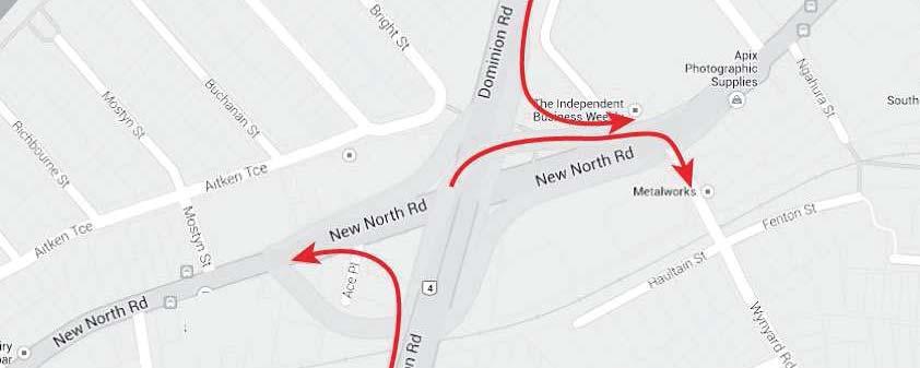
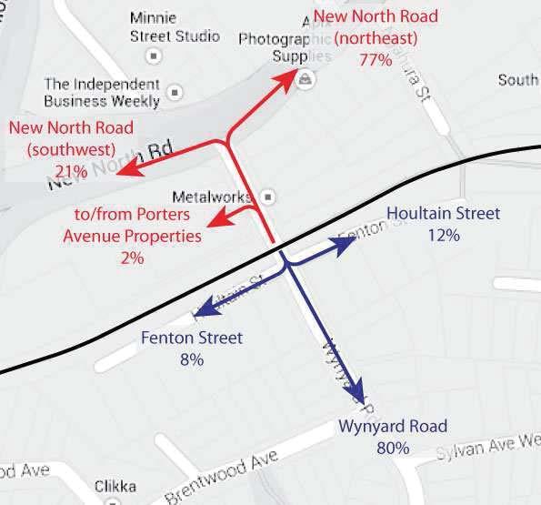
 and new North Road (northeast), in terms of both origins and destinations Conversely, the majority of pedestrian and cyclist trips are to/from New")
62 3 Figure 2: Porters Avenue Level Crossing General Traffic Movements (left) and Pedestrian/Cyclist Movements (right) It can be seen that: General traffic trips across the level crossing are relatively evenly split between New North Road (southwest) and new North Road (northeast), in terms of both origins and destinations Conversely, the majority of pedestrian and cyclist trips are to/from New North Road (northeast); this is thought to correspond to users heading to/from bus stops on New North Road (located to the northeast of Ngahura Street) or travelling to/from the city centre A large majority of pedestrian and cyclist trips south of the level crossing are to/from Wynyard Road While no survey was undertaken of the origins and destinations of general traffic to the south of the level crossing, it is expected that a large majority come from/are bound for Wynyard Road, as there are relatively few properties on either Fenton Street or Haultain Street. 3 POST CITY RAIL LINK As part of the City Rail Link (CRL) works, the Porters Avenue level crossing will be either grade separated or closed. The existing pedestrian level crossing at Ngahura Street, 140 m to the east, will be replaced with a grade separated pedestrian facility as part of a wider redevelopment of Mt Eden station. We understand that Auckland Transport is investigating the feasibility of a Transit Oriented Community (TOC) adjacent to the redeveloped Mt Eden station. If progressed, this TOC may result in the local streets bounded by the NAL, New North Road and Mt Eden Road being redeveloped with improved pedestrian amenity, a more connected grid network of streets, as well as additional or improved signalised pedestrian crossing opportunities of both New North Road and Mt Eden Road.


63 4 The above changes (with or without the TOC) will likely result in some existing pedestrian trips across the NAL shifting from Porters Avenue to Mt Eden station. This new pedestrian route is illustrated in Figure 3 below. Figure 3: Pedestrian Route Across North Auckland Line, Post CRL 4 SURROUNDING LAND USES South of the NAL, much of the existing land use is traditional low density residential, with a small strip of largely commercial property on the south boundary of the rail corridor. North of the NAL, and bounded by Ian Mckinnon Drive and Mt Eden Road, the existing land use is generally commercial. However, the commercial areas either side of the rail corridor are increasingly being intensified with medium to high density residential developments. This intensification is consistent with the Mixed Use zoning within the Proposed Auckland Unitary Plan (PAUP). The higher density land use is aligned with New North Road and the Eden Terrace area to the north, rather than with the low density residential area to the south. Significantly for pedestrian trips across the level crossing, the NAL forms the boundary between two primary school zones; the northern half is zoned for Newton Central school and the southern half zoned for Mt Eden Normal school. Both sides of the NAL are zoned for the same intermediate (Kowhai) and high school (Mt Albert Grammar). Major pedestrian destinations in the area include Basque Park, to the north, the Auckland Indian Association on the north side of New North Road between Porters Avenue and Ngahura Street, and the retail and community facilities of Eden Terrace (clustered around the intersection of New North Road, Symonds Street and Mt Eden Road).


64 5 5 EFFECTS OF LEVEL CROSSING CLOSURE 5.1 General Traffic Effects The Porters Avenue level crossing generally serves a local access function to the properties immediately either side of the NAL. These affected properties fall into two groups: A small, discrete group of commercial properties and apartment buildings accessed directly off Porters Avenue, between the NAL and New North Road A larger area of low density residential homes bounded by the NAL, View Road, Dominion Road and Esplanade Road, including a small strip of commercial properties and apartment buildings on the NAL boundary. These properties are less well defined than the northern group, but the catchment is broadly illustrated in Figure 5 overleaf. The first of these two property groups are shown in Figure 4. Also shown in Figure 4 are the likely routes taken to and from these properties that cross the Porters Avenue level crossing, and the volumes of traffic surveyed doing so during the morning and evening commuter peak hours. Figure 4: Traffic Routes to/from Properties North of Level Crossing, Existing (left) and Level Crossing Closed (right) If the level crossing is closed, the alternative routes across the rail line via Dominion Road and Mt Eden Road would be longer. Directly affected traffic volumes would be very low however, with the majority of vehicle trips to and from these properties already via New North Road (60% to 70% when surveyed in April 2014). Given these very low volumes, the effects of closing the level crossing on these properties are not thought to be significant. Figure 5 goes on to illustrate the existing vehicle trips across the level crossing to and from the second property group, to the south of the NAL. Again, existing hourly traffic volumes are shown for the commuter peaks.
65 6 Figure 5: Traffic Routes to/from Properties South of Level Crossing, Existing (left) and Level Crossing Closed (right) The catchment is estimated to contain in the order of 200 stand alone residential homes, in addition to a retirement village, several significant multi-storey residential developments, small blocks of flats and commercial premises. For occupants of these properties, the existing Porters Avenue level crossing will likely be the preferred route to and from New North Road, as well as onwards to the city centre and the motorway network. The closure of the level crossing would result in these vehicle trips redistributing to alternative routes. For trips to and from New North Road (southwest), this will result in: Trips to New North Road redistributing via either View Road or Brentwood Avenue, then Dominion Road, Charles Street and George Street Relatively small increases in trip distances of 350 m or less 4 Slightly increased travel time associated with the above distance, and additional travel time associated with crossing Dominion Road; this is estimated to be in the order of 30 to 60 seconds additional travel time 5, applicable to approximately 60 vehicles per hour each direction during the commuter peaks. For trips to and from New North Road (northeast), this will result in: Trips redistributing via View Road, Esplanade Road and Mt Eden Road Increased trip distances of up to 800 m to Newmarket and up to 1,400 m to the city centre 6 ; the greatest increases will be for properties nearest the NAL, while residential properties further south will experience lesser increases m increase for trips to/from Haultain Street/Fenton Street and Kingsland 5 Based on an estimated 30 second average delay turning right across Dominion Road, in addition to between 0 m and 350 m additional travel distance at 40 km/hr 6 Trips to/from Haultain Street and Fenton Street
66 7 Increased travel time associated with the above distance but relatively negligible increases in delays at intersections, estimated to be in the order of one to two minutes for some users, but negligible for others; again this would be applicable to approximately 60 vehicles per hour each direction Conversely, the existing route via Porters Avenue is subject to delays which would not affect the alternative route. These include delays incurred due to level crossing closures and delays incurred turning right onto New North Road. The above effects would apply only moderately to the low density residential properties stretching out to the south of the catchment, but more so for the commercial and higher density residential developments concentrated on Fenton Street and Haultain Street. A recently constructed six-storey residential development at 9 Fenton Street in particular will have been developed on the premise that direct vehicular access would be available to New North Road to the north, without a circuitous route through the residential streets to the south. The same will apply to a proposed apartment building at 1-3 Fenton Street. Overall, the effects of the closure are considered modest for traffic to/from New North Road (southwest), due to the low traffic volumes involved, short extra travel distances and modest travel time increases expected. For traffic to/from New North Road (northeast) however, the effects would be more noticeable, driven by the potential 1,400 m increase in travel distance for Fenton Street and Haultain Street traffic. Further, the rerouting of traffic associated with the apartment buildings and commercial properties on Fenton Street and Haultain Street through the residential streets to the south is undesirable. For these reasons, the provision of an alternative route is recommended. The above effects would similarly apply to emergency services accessing Porters Avenue. Porters Avenue is however ringed by emergency services, with eight police stations and three fire stations all 1.5 to 2.5 km distant. Given this spread, it is not clear what direction these emergency services will approach from or to what extent they may be inconvenienced. It is reasonable to expect however that these services would be subject to one to two minutes additional travel time to properties immediately south of the NAL, if they approach from the city centre. Similarly, Auckland Hospital would be an additional one to two minutes away from these properties. In terms of the wider traffic effects, the closure has been modelled previously, with the following outcomes identified: Reduced traffic is predicted on New North Road, in the order of 50 vehicles per hour in each direction during each commuter peak hour Increased traffic is predicted on Mt Eden Road, by up 75 to 100 vehicles per hour in the commuter peak directions, and approximately half of this in the contra-peak directions Increased use of the George Street level crossing (not quantified by the previous modelling, as this level crossing was assumed to be closed) Minor increases in traffic volumes are predicted on Normanby Road Other changes in traffic volumes are predicted to be negligible.
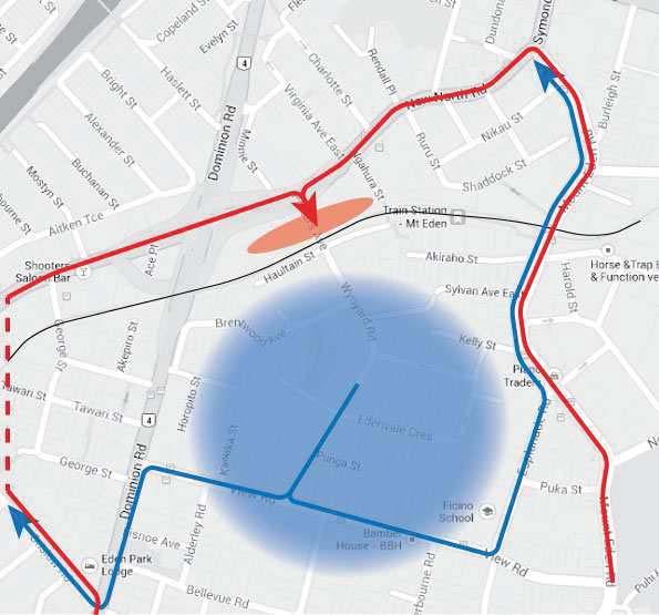
67 8 In terms of effects on the wider road network, these effects are not considered significant. In particular, the shift of trips from Porters Avenue to George Street is considered a positive effect from an intersection safety perspective, as the latter has a significantly simpler intersection with New North Road, without the safety concerns present at the Porters Avenue/New North Road intersection. We understand that the George Street intersection with New North Road was not identified as a priority site within the Vulnerable Road Users (VRU) Crash Reduction Study recently undertaken by Auckland Transport. As such, no improvement works were recommended for the intersection. The increased trips through George Street will result in additional conflict at this level crossing however. An assessment of queuing at this level crossing was undertaken using a spreadsheet model developed by Flow and used previously to assess level crossing operations across Auckland. The assessment found that should an additional southbound 60 vehicles per hour per direction use this level crossing due to the closure of Porter Avenue, the southbound queue would extend 40 m to 50 m during the busiest periods 7. This is within the 65 m available to the New North Road intersection. The northbound queue is not considered critical at this level crossing. It is concluded that there are no significant traffic operational effects predicted should the additional traffic use the George Street level crossing, and that there are no improvements required either to this level crossing or to the George Street intersection with New North Road to mitigate this increased use. It should be stressed however that this conclusion has not considered aspects relating to rail crossing safety or rail operations. An increase of 60 vehicles per hour per direction across the George Street level crossing would represent a directional increase of between 25% and 100% over existing volumes. It is expected that this would result in a higher level crossing risk profile when assessed against the Australian Level Crossings Assessment Model (ALCAM). The closure will also result in small increases in turning movements at the Dominion Road intersections with View Road, Charles Street and Horopito Street (for Brentwood Avenue). While the latter two are priority controlled intersections, right turn movements at these intersections are enabled by good sight distances, a flush median on Dominion Road, and gaps in the opposing traffic streams due to the traffic signals at View Road. As a result, the small increases are not considered significant and no mitigation is recommended Mitigation Those properties nearest the rail line and south of the level crossing would stand to lose vehicle accessibility to and from the city centre and motorway networks should the level crossing be closed, with their routes increased up to 1,400 m. It is recommended that this reduction in accessibility be mitigated. There are three potential mitigation options, listed below and shown in Figure 6: Reconnecting Edenvale Crescent to Kelly Street Reconnecting Sylvan Avenue West and East 7 This assessment assumed the number of trains per hour increase from the existing 8 to 21 post CRL, and that the maximum closure duration increase from the existing 90 seconds to up to three minutes, to reflect instances where two opposing trains pass the level crossing in succession.


68 9 Connecting Fenton Street to Akiraho Street Figure 6: Potential Vehicle Access Mitigation The Edenvale Crescent and Sylvan Avenue connections would in theory be easy to construct, as these previously connected streets were severed at some time in the past, but the road reserve remains. Edenvale Crescent, Kelly Street and Sylvan Avenue are all very narrow streets however, generally with 6 m carriageways and 9 m to 11 m road reserves. Figure 7 below shows a typical view of Sylvan Street East as an example. Figure 7: Sylvan Street East, Looking Towards Mt Eden Road As a result of these very constrained road geometries, none of these routes are considered suitable for even a small increase in traffic volumes. In addition, a connection via Edenvale Crescent would in itself be a somewhat indirect connection for the affected properties nearest the rail line, and would offer
69 10 only a very modest improvement in terms of travel distance over the View Road alternative, and potentially no improvement in terms of travel time. As a result, the only viable and effective mitigation is considered a link between Fenton Street and Akiraho Street. The latter street is relatively wide with an 11 m carriageway and 20 m road reserve, while Fenton Street has scope for improvements within its designation. The connection would require the purchase of the existing commercial property at 13 Akiraho Street, in addition to a strip of rail corridor. However, the route would pass through a pinch point at the cul-de-sac end of Fenton Street, where the road corridor narrows to approximately 5 m between a recently constructed apartment building at 9 Fenton Street and the rail corridor. This may be a fatal flaw for the Akiraho Street-Fenton Street link, should clearances to the rail lines not allow the road designation to be widened at this point. All three options would present potential consenting risks, perhaps most significantly the Edenvale Crescent/Kelly Street and Sylvan Avenue options. Residents of these very quiet, residential cul-de-sacs may object to their use by through traffic, no matter how limited. While Fenton Street is largely commercial and Akiraho Street already has large scale, relatively high vehicle generating commercial properties on its northern side, the Bear Park childcare centre at 32 Akiraho Street may similarly object to through traffic using this cul-de-sac. Sight distances at the Akiraho Street intersection with Mt Eden Road are good, and there are no apparent safety concerns that would need mitigating, if there were slightly increased traffic flows through the intersection. 5.2 Pedestrians and Cyclists Effects The majority of existing pedestrian trips across the Porters Avenue level crossing are to and from the northeast, via New North Road. The bulk of these users would be well catered for by the proposed pedestrian connections at Mt Eden station (shown in Figure 3). For the majority of key pedestrian destinations (Basque Park, New North Road bus stops and the Eden Terrace retail area) this will not represent a longer route. For trips to the Auckland Indian Association, this will result in very slightly longer pedestrian trips, but not significantly. For those pedestrians travelling to or from the southwest via either New North Road or Dominion Road, detouring via Ngahura Street would require longer route, by approximately 300 m. Some of these pedestrians may route via Brentwood Avenue and George Street, which would require a route only 150 m longer than existing to New North Road 8. These detours would affect in the order of 15 pedestrians per hour (based on existing pedestrian surveys). While a grade separated facility at the Porters Avenue level crossing would result in improved pedestrian access in this area, this improvement would not be significant, given the close proximity of an alternative at Ngahura Street. 8 This route requires crossing a four lane, 60 km/h section of Dominion Road without any crossing facilities, and will not be suitable for pedestrians of all abilities. It is noted however that the existing route requires pedestrians to cross several difficult uncontrolled crossings along New North Road.
70 11 Existing use of the Porters Avenue level crossing by cyclists is low, with fewer than ten cyclists recorded during each peak hour. The same effects discussed above in relation to pedestrians are expected to similarly apply to cyclists. Any increase in pedestrian and cyclist activity across the George Street level crossing is expected to be very minor, should the Porters Avenue level crossing be closed Mitigation Should only one pedestrian facility be provided across the NAL in this area (ie at Ngahura Street), this will concentrate pedestrian trips to and from New North Road to this single location. This consolidation of pedestrian trips may warrant a new signalised pedestrian crossing facility on New North Road at Ngahura Street. This area of Eden Terrace will however be the focus of significant change in the coming years, with the CRL resulting in a major redevelopment of Mt Eden Station, a potential major TOC development immediately to the north of the station, and increasing medium/high density residential developments elsewhere. Together, these changes will significantly alter travel demands by all modes in the area, and this warrants the development of an access strategy for this section of New North Road. This strategy should address the issue of pedestrian connectivity across New North Road. 6 EFFECTS OF GRADE SEPARATION Grade separation of the Porters Avenue level crossing would maintain all existing access provisions for general traffic, pedestrians and cyclists. It would likely however result in increased through traffic on Porters Avenue, by creating the perception that it is a suitable through route and somewhat legitimising its use as such. Increased traffic through the Porters Avenue intersection with New North Road would be a concern, as this complicated priority controlled intersection has existing safety concerns. Right turn movements out of Porters Avenue are awkward, due to a combination of: High traffic speeds on New North Road, particularly downhill The channelised, complicated traffic streams on New North Road The limited westward sight distance through the underpass. Any increase in traffic volumes through this intersection would justify a reconsideration of how this intersection operates; there is limited scope to do so however. We understand that the New North Road Vulnerable Road Users Crash Reduction Study recently undertaken by Auckland Transport recommended banning this right turn, but that this recommendation has not been pursued. If grade separated, we recommend that this right turn be banned. Suitable Local Area Traffic Management could be applied to Porters Avenue/Wynyard Road to discourage through traffic. This may however result in mixed messages being sent to road users, with the grade separated rail crossing suggesting it is a suitable through route. Residents may be
71 12 dissatisfied with the increase in through traffic created by grade separation, while through traffic may be dissatisfied with the inconvenience of the traffic calming measures. Reference: P:\atmp\033 CRL Porters Ave\TN1A Porters.docx - Michael Jongeneel
72 Appendix 4 Multicriteria attendees and options summary table 17 CRL/Porters Avenue Level Crossing/ December 2015
73

74
75

76

77
City Rail Link Designation Alteration: Mt Eden. Draft Integrated Transport Assessment
 Draft Integrated Transport Assessment July 2016 Project: Title: Document Reference: Prepared by: Reviewed by: Revisions: City Rail Link Designation Alteration: Mt Eden Integrated Transport Assessment R2A160509
Chapter 4 Route Window C3 Hyde Park and Park Lane shafts. Transport for London
 Chapter 4 Route Window C3 Hyde Park and Park Lane shafts Transport for London HYDE PARK AND PARK LANE SHAFTS 4 Route Window C3 Hyde Park and Park Lane shafts Introduction 4.1 In this route window, which
EXECUTIVE SUMMARY Callan Park accommodates travel from a wide range of transport modes, including walking, cycling, bus and light rail.
 TRANSPORT AND ACCESS EXECUTIVE SUMMARY Callan Park accommodates travel from a wide range of transport modes, including walking, cycling, bus and light rail. Whilst there are some walking facilities within
Transport Assessment. Curtis Street Plan Change
 Transport Assessment Curtis Street Plan Change Transport Assessment for Curtis Street Plan Change i Contents 1. Introduction... 1 2. Existing Conditions... 2 2.1 Location... 2 2.2 Study Area... 3 2.3
1.5 On this basis it is fundamental that the Transport Strategy for the site focuses on the following key criteria,
 1.0 Introduction 1.1 The Transport Assessment has been prepared on behalf of Eon and Roger Bullivant Ltd in respect of the proposed mixed use sustainable urban extension of Drakelow Park. 1.2 The methodology
Ministry of Education Flat Bush School Notice of Requirement. Integrated Transportation Assessment Report. February 2016
 Ministry of Education Flat Bush School Notice of Requirement Integrated Transportation Assessment Report February 2016 TDG Ref: 12988-2 151105 ita flat bush.docx Ministry of Education Flat Bush School
RIVER CROSSINGS: EAST OF SILVERTOWN CROSSINGS
 TRANSPORT FOR LONDON RIVER CROSSINGS: EAST OF SILVERTOWN CROSSINGS SUPPORTING TECHNICAL DOCUMENTATION TRAFFIC IMPACT REPORT Neil Georgeson July 2014 This report examines the traffic impacts that potential
SCHEME DESIGN AND ENGINEERING
 THE NORTH SOMERSET COUNCIL (SOUTH BRISTOL LINK CLASSIFIED ROAD) SIDE ROADS ORDER 2013 THE NORTH SOMERSET COUNCIL (SOUTH BRISTOL LINK) COMPULSORY PURCHASE ORDER 2013 THE NORTH SOMERSET COUNCIL (SOUTH BRISTOL
Kings College, Otahuhu Proposed Plan Change. Integrated Transportation Assessment Report
 Proposed Plan Change Integrated Transportation Assessment Report 23 October 2017 Project: Report title: Document reference: Kings College, Otahuhu Integrated Transportation Assessment Report J00700 Kings
M6 Junction 10 Public Consultation
 M6 Junction 10 Public Consultation December 2015 Introduction Walsall Council and Highways England are developing plans to provide a long term improvement to M6 junction 10. We are holding this non-statutory
Tonight is an opportunity to learn about the Study and ask questions of the Study Team members.
 Exhibit 1 Welcome Second Open House Tonight is an opportunity to learn about the Study and ask questions of the Study Team members. A first Public Open House was held on September 18th, 2013 which presented
Southwest Bus Rapid Transit (SW BRT) Functional Planning Study - Executive Summary January 19 LPT ATTACHMENT 2.
 Functional Planning Study - Executive Summary January 19 LPT ATTACHMENT 2.") Southwest Bus Rapid Transit (SW BRT) Functional Planning Study - Executive Summary 2011 January 19 1 of 19 Introduction This executive summary presents the results of the Southwest Bus Rapid Transit (SW
Southwest Bus Rapid Transit (SW BRT) Functional Planning Study - Executive Summary 2011 January 19 1 of 19 Introduction This executive summary presents the results of the Southwest Bus Rapid Transit (SW
M-58 HIGHWAY ACCESS MANAGEMENT STUDY Mullen Road to Bel-Ray Boulevard. Prepared for CITY OF BELTON. May 2016
 M-58 HIGHWAY ACCESS MANAGEMENT STUDY Prepared for CITY OF BELTON By May 2016 Introduction Missouri State Highway 58 (M-58 Highway) is a major commercial corridor in the City of Belton. As development has
At each type of conflict location, the risk is affected by certain parameters:
 TN001 April 2016 The separated cycleway options tool (SCOT) was developed to partially address some of the gaps identified in Stage 1 of the Cycling Network Guidance project relating to separated cycleways.
North West Non-Technical Summary of the Transport Assessment September 2011
 North West Non-Technical Summary of the Transport Assessment September 2011 Introduction This is a Non-Technical Summary of the findings of the Transport assessment work undertaken for the proposed North
Downtown BRT Corridor Alternatives Review: 1 st, 2 nd, 3 rd and 4 th Avenue. Bus Rapid and Conventional Transit Planning and Design Services
 Downtown BRT Corridor Alternatives Review: 1 st, 2 nd, 3 rd and 4 th Avenue Bus Rapid and Conventional Transit Planning and Design Services City of Saskatoon February 2018 Project Team HDR Corporation
Frome Street Bicycle Route
 The Adelaide City Council invites engagement from the community about Frome Street Bicycle Route Project Summary Adelaide City Council is seeking feedback on design options to construct bicycle facilities
PAEKĀKĀRIKI HILL ROAD / BEACH ROAD / SH1 INTERSECTION PROGRESS REPORT
 Chairperson and Committee Members ENVIRONMENT AND COMMUNITY DEVELOPMENT COMMITTEE 6 DECEMBER 2011 Meeting Status: Public Purpose of Report: For Decision PAEKĀKĀRIKI HILL ROAD / BEACH ROAD / SH1 INTERSECTION
Classification Criteria
 SCHEDULE D TO RECOMMENDED OFFICIAL PLAN AMENDMENT NO. 40 SCHEDULE C-4 Road Criteria Criteria Traffic Service Objective Land Service/Access Typical Daily Traffic Volume Flow characteristics Travel Speed
Sandyford Cycle Route (Kilgobbin / Drummartin Link Road)
") Sandyford Cycle Route (Kilgobbin / Drummartin Link Road) Public Consultation Report on Submissions Client: Dun Laoghaire-Rathdown County Council Date: May 2018 Job Number: 15_116B Clifton Scannell Emerson
Sandyford Cycle Route (Kilgobbin / Drummartin Link Road) Public Consultation Report on Submissions Client: Dun Laoghaire-Rathdown County Council Date: May 2018 Job Number: 15_116B Clifton Scannell Emerson
WELCOME. Stakeholder Involvement Group Meeting #2 Round Lake Public Works October 24, 2018
 WELCOME Stakeholder Involvement Group Meeting #2 Round Lake Public Works October 24, 2018 MEETING AGENDA 1. Welcome and Introductions 2. Study Progress Update 3. Problem Statement 4. Technical Analysis
72 Crossrail Amendment of Provisions
 72 Crossrail Amendment of Provisions Manhattan Shaft Worksite 5.4.36 This new worksite is adjacent to the Tumbling Bay worksite and will occupy an area of land between the Manhattan Building and the Great
4 DISRUPTION MANAGEMENT PLAN HIGHWAY 7 RAPIDWAY CONSTRUCTION BETWEEN BAYVIEW AVENUE AND WARDEN AVENUE TOWNS OF MARKHAM AND RICHMOND HILL
 4 DISRUPTION MANAGEMENT PLAN HIGHWAY 7 RAPIDWAY CONSTRUCTION BETWEEN BAYVIEW AVENUE AND WARDEN AVENUE TOWNS OF MARKHAM AND RICHMOND HILL The Transportation Services Committee recommends the adoption of
Comments EXECUTIVE SUMMARY
 Comments 1. Under any Alternatives, MCDOT should provide better at-grade pedestrian crossing of Georgia Avenue and Forest Glen Road, including improved crosswalks with wider medians and adequate signal
APPENDIX 2 LAKESHORE ROAD TRANSPORTATION REVIEW STUDY EXECUTIVE SUMMARY
 APPENDIX 2 LAKESHORE ROAD TRANSPORTATION REVIEW STUDY EXECUTIVE SUMMARY Appendix 2 City of Mississauga Lakeshore Road FINAL REPORT Transportation Review Study December 2010 EXECUTIVE SUMMARY Study Purpose
MILTON ROAD LLF PROJECT UPDATE
 Greater Cambridge City Deal MILTON ROAD LLF PROJECT UPDATE 9 th May 2017 Project objectives Comprehensive priority for buses in both directions wherever practicable; Additional capacity for sustainable
Scarlett Road Bridge & Road Improvements Lambton Park Community School - Gymnasium Tuesday November 28 th, 2017
 Scarlett Road Bridge & Road Improvements Lambton Park Community School - Gymnasium Tuesday November 28 th, 2017 PROJECT LOCATION 2 SCARLETT ROAD BRIDGE Constructed in 1912, the bridge carries 4 active
Southside Road. Prepared for: City of St. John s Police & Traffic Committee. Prepared by: City of St. John s Traffic Division
 Southside Road Prepared for: City of St. John s Police & Traffic Committee Prepared by: City of St. John s Traffic Division January 2007 Southside Road - Traffic Report Page 1 of 9 BACKGROUND: th At the
102 Avenue Corridor Review
 February 26, 2015 102 Avenue Corridor Review Transportation Association of Canada Road Safety Engineering Award Submission for the City of Edmonton Introduction Transportation Association of Canada Road
Chelmsford City Growth Package
 Chelmsford City Growth Package Public Consultation Document Volume 2 West Chelmsford July - August 2017 Chelmsford City Growth Package Public Consultation Document - Volume 2 - West Chelmsford Contents
Rhebogue Neighbourhood Greenway. Road Safety Audit Stage 2
 Rhebogue Neighbourhood Greenway Road Safety Audit Stage 2 Report Number: 12/007/00/00057 July 2014 Mid West National Road Design Office Lissanalta House, Dooradoyle County Limerick Tel: 061 496 800 Fax:
8 PROPOSED ROUNDABOUT DUFFERIN STREET AND KING VAUGHAN ROAD INTERSECTION CITY OF VAUGHAN
 8 PROPOSED ROUNDABOUT DUFFERIN STREET AND KING VAUGHAN ROAD INTERSECTION CITY OF VAUGHAN The Transportation Services Committee recommends the adoption of the recommendation contained in the following report
IMPACT OF THE BERMUDA CONNECTIVITY PROJECT ON CYCLING
 IMPACT OF THE BERMUDA CONNECTIVITY PROJECT ON CYCLING BBAG BRIEFING NOTE EMAIL: BERMUDABRIDGEAGP@BTINTERNET.COM WWW.FACEBOOK.COM/GROUPS/BERMUDABRIDGEAG TWITTER @BERMUDABRIDGEAG CYCLING BBAG BRIEFING NOTE
To: The results of these surveys have been analysed and are summarised within this Technical Note.
 Technical Note Project: Histon Road / Milton Road, Cambridge Parking Surveys To: Andy Harrison Subject: Survey Report v1.6 From: Jonathan Barlow Date: 18 th February 2016 cc: Richard Jones / Dave Boddy
Washington St. Corridor Study
 FIGURE 7.17 Bridge Alternatives - Cross Sections 86 Discarded Alternative: Short-Term Bridge Repair Short-term repairs and west bridge span replacement were considered during analysis. Short-term repairs
Pedestrian Level Crossings Design and Installation
 Discipline: Engineering (Track & Civil) Category: Standard Pedestrian Level Crossings Design and Installation ETD-16-03 Applicability New South Wales CRIA (NSW CRN) Primary Source ARTC NSW Standard XDS
March Maidstone Integrated Transport Strategy Boxley Parish Council Briefing Note. Context. Author: Parish Clerk 2 March 2016
 Context. Author: Parish Clerk 2 The Draft Integrated Transport Policy (DITS) sets out a vision and objectives, and identifies a detailed programme of interventions to support the Maidstone Borough Local
Corporate. Report COUNCIL DATE: May 25, 1998 NO: R1500 REGULAR COUNCIL. TO: Mayor & Council DATE: April 27, 1998
 R1500 : Traffic Safety at 25 Avenue and 128 Street Intersection Corporate NO: R1500 Report COUNCIL DATE: May 25, 1998 REGULAR COUNCIL TO: Mayor & Council DATE: April 27, 1998 FROM: General Manager, Engineering
Speed Limits in the Hoddle Grid
 Speed Limits in the Hoddle Grid Recent History of speed limits March 2013 Docs # 7738485 1 Introduction Muncipalities have power to Erect speed limit signs BUT Municipalities DO NOT have the power to approve
Corporate. Report COUNCIL DATE: June 26, 2006 NO: C012 COUNCIL-IN-COMMITTEE. TO: Mayor & Council DATE: June 22, 2006
 Corporate NO: C012 Report COUNCIL DATE: June 26, 2006 COUNCIL-IN-COMMITTEE TO: Mayor & Council DATE: June 22, 2006 FROM: General Manager, Engineering FILE: 0410-20(MoT/Gate) SUBJECT: Surrey Response on
Speed Limit Policy Isle of Wight Council
 APPENDIX B Speed Limit Policy Isle of Wight Council 2009 Contents Section 1 Introduction 1.1 Links with the Local Transport Plan Section 2 Speed Limits on Urban Roads and Residential Areas 2.1 20mph Limits
ONE SIZE DOESN T FIT ALL RECONCILING OVERLAPPING TRANSPORT NETWORKS IN A CONSTRAINED URBAN ENVIRONMENT
 One Size Doesn t Fit All S Corbett, C Chenery Page 1 ONE SIZE DOESN T FIT ALL RECONCILING OVERLAPPING TRANSPORT NETWORKS IN A CONSTRAINED URBAN ENVIRONMENT Authors/Presenters: Sam Corbett, Principal Transport
CAMBRIDGE SOUTH WEST PARK & RIDE
 CAMBRIDGE SOUTH WEST PARK & RIDE Have your say on: Extra Park & Ride spaces to the south west of Cambridge Bus priority measures into the city centre CREATING MORE PARK & RIDE SPACES The existing Park
1.3.4 CHARACTERISTICS OF CLASSIFICATIONS
 Geometric Design Guide for Canadian Roads 1.3.4 CHARACTERISTICS OF CLASSIFICATIONS The principal characteristics of each of the six groups of road classifications are described by the following figure
11.2 Detailed Checklists CHECKLIST 1: FEASIBILITY STAGE AUDIT. 1.1 General topics Scope of project; function; traffic mix
 11.2 Detailed Checklists CHECKLIST 1: FEASIBILITY STAGE AUDIT 1.1 General topics 1.1.1 Scope of project; function; traffic mix What is the intended function of the scheme? Is the design consistent with
EUCLID AVENUE PARKING STUDY CITY OF SYRACUSE, ONONDAGA COUNTY, NEW YORK
 EUCLID AVENUE PARKING STUDY CITY OF SYRACUSE, ONONDAGA COUNTY, NEW YORK CITY OF SYRACUSE DEPARTMENT OF PUBLIC WORKS 1200 CANAL STREET EXTENSION SYRACUSE, NEW YORK 13210 DRAFT REPORT DATE: November 13,
The existing site constraints which may be encountered for the A428 scheme proposals are divided into sections as follows.
 Project: A428 Study To: Cambridgeshire County Council Subject: Tidal Bus lane Review From: Atkins Date: 24 May 2016 cc: Introduction As part of the A428 Corridor Study to improve the bus journey time between
Improving Cyclist Safety at the Dundas Street West and Sterling Road Intersection
 STAFF REPORT ACTION REQUIRED Improving Cyclist Safety at the Dundas Street West and Sterling Road Intersection Date: August 17, 2012 To: From: Wards: Reference Number: Public Works and Infrastructure Committee
South Albion-Bolton Community Plan North Hill Supermarket Transportation Study Part B: Evaluation of Alternatives
 Community Plan North Hill Supermarket Transportation Study Part B: Evaluation of Alternatives Prepared for: The Town of Caledon August 9 Transportation Solutions Ltd. 43 Forest Road Cambridge, ON N1S 3B4
University Hill Transportation Study Technical Memorandum Alternatives Modeling and Analysis May 2007
 Technical Memorandum May 2007 Syracuse Metropolitan Transportation Council Edwards and Kelcey with Wallace Roberts and Todd Alta Planning and Design CONTENTS SECTION ONE- INTRODUCTION...1 SECTION TWO-
Attachment A: Traffic Mitigation Measures
 Attachment A: Traffic Mitigation Measures Central Interceptor Main Project Works Watercare Services Limited This appendix outlines examples of detailed mitigation measures that could be implemented for
Appendix 5B Accessway standards and guidelines Appendix 5B Accessway standards and guidelines
 Appendix 5B standards and guidelines Appendix 5B standards and guidelines 204 Appendix 5B standards and guidelines Introduction This Appendix sets out Transit s safety standards for accessways onto state
Resident s Toolkit Traffic Control Device Local Area Traffic Management
 Resident s Toolkit Traffic Control Device Local Area Traffic Management This booklet contains information on traffic control devices commonly used in South Australia. A traffic control device is a sign,
A127/A130 Fairglen Interchange Improvement Schemes. Information Leaflet February 2017
 A127/A130 Fairglen Interchange Improvement Schemes Information Leaflet February 2017 1 2 Foreword By Councillor Kevin Bentley Essex is continuing to grow as a vibrant economic hub and as a fantastic place
CHECKLIST 2: PRELIMINARY DESIGN STAGE AUDIT
 CHECKLIST 2: PRELIMINARY DESIGN STAGE AUDIT 2.1 General topics 2.1.1 Changes since previous audit Do the conditions for which the scheme was originally designed still apply? (for example, no changes to
Chapter 5 Future Transportation
 Chapter 5 Future Transportation The Future Land Use Plan identifies the desired land use designations. The land uses desired for Crozet depend, in large part, on the success of the transportation system,
SH1 Western Belfast Bypass Transportation Assessment
 SH1 Western Belfast Bypass Transportation Assessment WBB- Transportation Assessment i This report has been prepared on behalf of the NZ Transport Agency (NZTA). No liability is accepted by this company
Bus and Transit Lane Review Update
 Board Meeting / 25 February 2013 Agenda Item no.8(i) Bus and Transit Lane Review Update Glossary Auckland Transport New Zealand Transport Agency Transit Two Transit Three (AT) (NZTA) (T2) (T3) Executive
IAN WHITE ASSOCIATES. Crawley Station Gateway Public Realm
 IAN WHITE ASSOCIATES Crawley Station Gateway Public Realm contents 1. objectives & client brief 2. site appraisal 3. best practice guidance 4. design concept 1. objectives & client brief Crawley Train
5. RUNNINGWAY GUIDELINES
 5. RUNNINGWAY GUIDELINES These guidelines should be considered collectively when making runningway decisions. A runningway is the linear component of the transit system that forms the right-of-way reserved
GLEN EIRA CITY COUNCIL. MURRUMBEENA Transforming our neighbourhood together our concepts based on your ideas
 GLEN EIRA CITY COUNCIL MURRUMBEENA Transforming our neighbourhood together our concepts based on your ideas 1 WHAT HAVE WE HEARD? WHAT NOW? Stage one Tell us what you love about your shopping strip November
A5.1 Permitted activities
 Section A5 Transportation A5.1 Permitted activities A5.1.1 Activities within roads Note: Refer to Section D for the definition of road (a) Any activity associated with the movement of traffic and the functioning
Agenda Item # Page # RECOMMENDATION
 TO: FROM: SUBJECT: CHAIR AND MEMBERS CIVIC WORKS COMMITTEE MEETING ON FEBRUARY 2, 2016 JOHN BRAAM, P. ENG. MANAGING DIRECTOR, ENVIRONMENTAL & ENGINEERING SERVICES AND CITY ENGINEER FIELD MARSHAL WOLSELEY
Frascati Road and Temple Hill Route Improvements. Outline Design Report to Accompany Public consultation
 Frascati Road and Temple Hill Route Improvements Outline Design Report to Accompany Public consultation September 2013 Background: Dún Laoghaire-Rathdown is committed to providing high quality pedestrian
Northern Beaches Bus Rapid Transit (BRT) Pre-Feasibility Study. Summary Report
 Pre-Feasibility Study. Summary Report") Northern Beaches Bus Rapid Transit (BRT) Pre-Feasibility Study Summary Report Contents 1. Introduction 1 2. Development of options 3 2.1 Shortlist of options 4 2.2 Travel time improvements 6 3. North-South
Northern Beaches Bus Rapid Transit (BRT) Pre-Feasibility Study Summary Report Contents 1. Introduction 1 2. Development of options 3 2.1 Shortlist of options 4 2.2 Travel time improvements 6 3. North-South
APPENDIX 11 WIND EFFECTS ASSESSMENT
 APPENDIX 11 WIND EFFECTS ASSESSMENT Summerset Villages (Lower Hutt) Ltd District Plan Change Request Prepared by Urban Perspectives Ltd 17 September 2014 341 49 342 Opus Research Report 14-529D84.00 Wind
PROPOSED RESIDENTIAL SUBDIVISION
 PROPOSED RESIDENTIAL SUBDIVISION PART OF TARNEIT ROAD & 1121 DOHERTYS ROAD, TARNEIT Prepared For: TCG (RM) Developments Pty Ltd MARCH 2014 OUR REF: 16740R#1 PROPOSED RESIDENTIAL SUBDIVISION PART OF TARNEIT
1 VicRoads Access Management Policies May 2006 Ver VicRoads Access Management Policies May 2006 Version 1.02
 1 VicRoads Access Management Policies May 2006 Ver 1.02 VicRoads Access Management Policies May 2006 Version 1.02 2 VicRoads Access Management Policies May 2006 Ver 1.02 FOREWORD FOR ACCESS MANAGEMENT
Harriet Fraser Traffic Engineering & Transportation Planning
 Appendix 5: Traffic Assessment 71 26 February 2015 Mr James Beban Senior Resource Consents Planner Cuttriss Consultants Ltd PO Box 30429 Lower Hutt PO Box 40170 Upper Hutt 5140 P 04 526 2979 M 027 668
CURBSIDE ACTIVITY DESIGN
 5 CURBSIDE ACTIVITY DESIGN This chapter provides design guidance for separated bike lanes adjacent to curbside activities including parking, loading and bus stops. Typical configurations are presented
3 TRAFFIC CONTROL SIGNAL TIMING AND SYNCHRONIZATION
 Report No. 8 of the Transportation Services Committee Regional Council Meeting of October 20, 2011 3 TRAFFIC CONTROL SIGNAL TIMING AND SYNCHRONIZATION The Transportation Services Committee recommends:
Appendix D Stage 1 Road Safety Audit
 N2 Monaghan Town to Emyvale Road Improvements Part 8 Application Description of Proposed Development Appendi D N2 Monaghan Town to Emyvale, County Monaghan Proposed Pavement and Minor Improvement Scheme
Blair/Williamson Intersection Expressed Needs
 Blair/Williamson Intersection Expressed Needs NORTH Blair Street is a barrier for pedestrians and bicycles Relocate Capitol City Trail crossing from Blair Street and John Nolen Drive intersection to Williamson
Technical note. 1. Introduction
 Project: A428 study - Phase 2 To: Adrian Shepherd Subject: Park & Ride site locations From: Atkins Date: Jun 3, 2016 cc: Ashley Heller 1. Introduction 1.1. Purpose of Technical Note The purpose of this
6. BREENS/GARDINERS/HAREWOOD INTERSECTION - SAFETY IMPROVEMENT PROJECT
 6. BREENS/GARDINERS/HAREWOOD INTERSECTION - SAFETY IMPROVEMENT PROJECT General Manager responsible: Officer responsible: Author: Jane Parfitt General Manager City Environment DDI 941 8656 Michael Aitken
Cycle traffic and the Strategic Road Network. Sandra Brown, Team Leader, Safer Roads- Design
 Cycle traffic and the Strategic Road Network Sandra Brown, Team Leader, Safer Roads- Design Highways England A Government owned Strategic Highways Company Department for Transport Road Investment Strategy
WELCOME TO OPEN HOUSE # 1 June 14, 2017
 Langstaff Road Weston Road to Highway 7 Class Environmental Assessment Study WELCOME TO OPEN HOUSE # 1 June 14, 2017 Please sign in and join our mailing list Purpose of Open House #1 & Study Area York
Appendix B Transportation Report
 Project File Report Appendix B Transportation Report Town of Whitby HMM Project No. 327878 Final Report October 2014 Revision and Version Tracking CP Rail Crossing at New Coronation Road Class EA Study
Interstate Route 77 / US Route 62 / State Route 687 (Fulton Road) Transportation Improvement Project. Prepared September 6, 2017
 Transportation Improvement Project. Prepared September 6, 2017") EODOT Project: ODOT Project: STA-IR 77-.50; PID 00290 Interstate Route 77 / US Route 62 / State Route 687 (Fulton Road) Transportation Improvement Project Summary of Public Comments Received and Responses
EODOT Project: ODOT Project: STA-IR 77-.50; PID 00290 Interstate Route 77 / US Route 62 / State Route 687 (Fulton Road) Transportation Improvement Project Summary of Public Comments Received and Responses
Guildwood Village Traffic Response Prepared by City of Toronto Transportation Department
 Guildwood Village Traffic Response Prepared by City of Toronto Transportation Department 1. Traffic Impacts Associated With Improvements to the Lake Shore East GO Transit Rail Corridor Proposed by Metrolinx
The Cabinet Member for Highways & Streetscene. Aurang Zeb - Head of Highways & Transport
 LONDON BOROUGH OF RICHMOND UPON THAMES Cabinet Member Decision DATE: January 2012 REPORT OF: LEAD OFFICER: SUBJECT: WARDS: The Cabinet Member for Highways & Streetscene Aurang Zeb - Head of Highways &
MUTCD Part 6G: Type of Temporary Traffic Control Zone Activities
 MUTCD Part 6G: Type of Temporary Traffic Control Zone Activities 6G.01 Typical Applications Each temporary traffic control (TTC) zone is different. Many variables, such as location of work, highway type,
TRAFFIC IMPACT STUDY CRITERIA
 Chapter 6 - TRAFFIC IMPACT STUDY CRITERIA 6.1 GENERAL PROVISIONS 6.1.1. Purpose: The purpose of this document is to outline a standard format for preparing a traffic impact study in the City of Steamboat
Route 7 Corridor Study
 Route 7 Corridor Study Executive Summary Study Area The following report analyzes a segment of the Virginia State Route 7 corridor. The corridor study area, spanning over 5 miles in length, is a multi
NORTH TURNAROUND. Recommended Design: Expand the existing transit terminal
 NORTH TURNAROUND Recommended Design: Expand the existing transit terminal Feedback from stakeholders and the public: Make it easy to transfer between local and Rapid Transit service Why is this design
Frequently Asked Questions (FAQ)
") Frequently Asked s (FAQ) Study Process... 2 Rapid Transit Service and Operations... 5 Public Consultation... 8 Business Impacts... 8 Design and Property Impacts... 9 Construction Impacts...12 Traffic,
Frequently Asked s (FAQ) Study Process... 2 Rapid Transit Service and Operations... 5 Public Consultation... 8 Business Impacts... 8 Design and Property Impacts... 9 Construction Impacts...12 Traffic,
METHODOLOGY. Signalized Intersection Average Control Delay (sec/veh)
") Chapter 5 Traffic Analysis 5.1 SUMMARY US /West 6 th Street assumes a unique role in the Lawrence Douglas County transportation system. This principal arterial street currently conveys commuter traffic
Chapter 5 Traffic Analysis 5.1 SUMMARY US /West 6 th Street assumes a unique role in the Lawrence Douglas County transportation system. This principal arterial street currently conveys commuter traffic
Appendix 12 Parking on footways and verges
 Appendix 12 Parking on footways and verges Legal position Parking on footways and verges whether wholly or partly is banned throughout London, unless signs are placed to allow parking. The ban requires
Design and Installation of Low Level Cycle Signals
 Transport for London Surface Transport Management System Document Guidance Note Design and Installation of Low Level Cycle Signals Document reference: SQA-0651 - Issue: Draft out of date information. 1
MILTON ROAD ~ MITCHAM'S CORNER PARAMICS MODEL INITIAL OPTION TESTING
 MILTON ROAD ~ MITCHAM'S CORNER PARAMICS MODEL INITIAL OPTION TESTING NOVEMBER 216 MILTON ROAD ~ MITCHAM'S CORNER PARAMICS MODEL INITIAL OPTION TESTING Cambridgeshire County Council Type of document (version)
AGENDA REPORT. Issue: Discussion of potential improvements on Barnwell Road at Niblick Drive
 AGENDA REPORT To: From: By: Honorable Mayor and City Council Members Warren Hutmacher, City Manager Tom Black, Public Works Director Date: March 23, 2016 Agenda: March 28, 2016 WORK SESSION AGENDA: Barnwell
WEST AND SOUTH WEST RING ROAD DOWNSTREAM TRAFFIC IMPACTS
 Page 1 of 9 EXECUTIVE SUMMARY Alberta Transportation ( AT ) is preparing to construct the final sections of the Calgary Ring Road. This includes the South West Ring Road ( SWRR ) (from Lott Creek Blvd
Rideau Canal Corridor Pedestrian Crossing Study. Queen Elizabeth Dr.: Preston St. to Laurier Ave. & Colonel By Drive: Hog s Back to Daly Ave.
 Rideau Canal Corridor Pedestrian Crossing Study Queen Elizabeth Dr.: Preston St. to Laurier Ave. & Colonel By Drive: Hog s Back to Daly Ave. Background: Canal parkways evolved over past 100 years Today
Access Location, Spacing, Turn Lanes, and Medians
 Design Manual Chapter 5 - Roadway Design 5L - Access Management 5L-3 Access Location, Spacing, Turn Lanes, and Medians This section addresses access location, spacing, turn lane and median needs, including
PEDESTRIAN ACTION PLAN
 ATTACHMENT 2 CITY OF SANTA MONICA PEDESTRIAN ACTION PLAN CITY OF SANTA MONICA PEDESTRIAN ACTION PLAN This page intentionally left blank EXECUTIVE SUMMARY CHAPTER 1 EXECUTIVE SUMMARY Setting the Stage
BELFAST RAPID TRANSIT. Ciarán de Búrca Director, Transport Projects Division Department for Regional Development
 BELFAST RAPID TRANSIT Ciarán de Búrca Director, Transport Projects Division Department for Regional Development Objectives of Belfast Rapid Transit To provide a modern, safe, efficient and high quality
Chapter 4 Traffic Analysis
 Chapter 4 Traffic Analysis PURPOSE The traffic analysis component of the K-68 Corridor Management Plan incorporates information on the existing transportation network, such as traffic volumes and intersection
McKenzie Interchange Project Fall 2015 Engagement. Appendix 2: Engagement Materials and Feedback Form
 Fall 2015 Engagement Appendix 2: Engagement Materials and Feedback Form Welcome to the McKenzie Interchange Project Open House! Purpose of Open House To provide you with information regarding the project
CITY OF HAMILTON PLANNING AND ECONOMIC DEVELOPMENT DEPARTMENT Transportation Planning and Parking Division
 CITY OF HAMILTON PLANNING AND ECONOMIC DEVELOPMENT DEPARTMENT Transportation Planning and Parking Division TO: Chair and Members Public Works Committee COMMITTEE DATE: June 18, 2018 SUBJECT/REPORT NO:
TRANSPORTATION ANALYSIS REPORT US Route 6 Huron, Erie County, Ohio
 TRANSPORTATION ANALYSIS REPORT US Route 6 Huron, Erie County, Ohio December 12, 2012 Prepared for: The City of Huron 417 Main Huron, OH 44839 Providing Practical Experience Technical Excellence and Client