DART Green Line. Northwest Corridor Expansion. Bachman/Northwest Dallas Update. May 10, Bachman Recreation Center
|
|
|
- Blaze Harmon
- 5 years ago
- Views:
Transcription

1 DART Green Line Northwest Corridor Expansion Bachman/Northwest Dallas Update Bachman Recreation Center May 10, 2007
2 AGENDA Background Stations Construction - Street Closures / Detours - Traffic Management Pre-construction Survey Process Safety and Transit Education Questions 2


3 Light Rail Expansion through 2018 Northwest Corridor 2010 Rowlett Corrid or 2012 Irving/DFW Corridor nd Downtown Alignment 2014 Southeast Corridor South Oak Cliff Extension


4 Green Line Expansion Victory Station open Special event service until 2009 Revenue service will start in new stations 11 Northwest 8 Southeast Design complete Construction in progress $700 M Federal grant 4


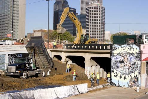
5 Green Line Southeast Corridor Construction 5

6 Green Line Northwest Corridor Construction 6
7 Stations Bachman Walnut Hill/Denton Royal Lane Other Facilities: Northwest Rail Operating Facility


8 Bachman Station At-grade station 464 parking spaces 3-track station Irving/DFW Orange Line junction


9 Walnut Hill/Denton Station Aerial station 369 parking spaces


10 Royal Lane Station Aerial station Nearly 200 parking spaces

11 Rail Operating Facility Denton Lombardy Abernathy Lombardy Denton Century (to be permanently closed at Denton)
12 Potential Project Change Current design reflects elevated LRT alignment from Northwest Highway to north of Northhaven Potential change under discussion: Bring alignment to grade sooner, north of Royal Lane and Zelrich Affects Rodney, Indian Trail, Northhaven Current shown as crossing under elevated structure Could be at-grade crossings or rerouted 12
13 Potential Project Change Denton Drive Zelrich Grissom Rodney Indian Trail Northhaven Rodney New at-grade crossing with signalized intersection at Denton Indian Trail Access to Denton Drive rerouted to Rodney on new oneway (SB) roadway Northhaven New atgrade crossing with signalized intersection at Denton Drive 13
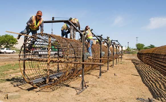
14 Construction Overview Construction to the south in progress Construction in this area to start June 2007 Site specific meetings as necessary during construction Construction approach: 1 st : Right-of-way preparation, utility work and freight relocation 2 nd: Civil work to construct new LRT track and stations, including street crossing closures and intersection improvements 3 rd : Systems and testing (for LRT power and signal systems) Approximately 3 ½ year process 14

15 Construction Overview Activities in progress: Utility relocations by franchise utilities Earthwork and rough grading on guide way Street modifications Install piers for foundations of station and guide way structures
16 Construction Overview Future Activities: Track deliveries Street/lane closures, detours Construction Hours: M-F: 7:00 AM to 7:00 PM Sat: 8:00 AM to 7:00 PM Sun: By Special Permit
17 Track Delivery Train will deliver track in mid-late June Rail pile will be placed between Century and Blystone Traffic control plan to be approved by City of Dallas
18 Street Reconstruction Parallel streets and cross streets will be affected Temporary street/lane closures Detours Permanent closures Traffic management/control plans are developed and approved by City
19 Traffic Management Basic Definitions Keep informed of traffic management by checking regularly Daily Lane Closure - Redirecting of vehicular traffic with cones, barricades and flagmen during non peak hours. - Normal traffic operations restored during peak and evening hours.
20 Traffic Management Basic Definitions Traffic Switch Redirecting of vehicular traffic to a new traffic pattern for a specific period of time. Traffic movement is maintained but generally with one lane of traffic in one direction.
21 Traffic Management Basic Definitions Detour Redirecting vehicular traffic to adjacent streets while an intersection is being reconstructed. Traffic movement is reinstated once all work is completed.
22 Street Reconstruction Future construction: Access drive from Shorecrest to Walters Lane properties (DART rail will be elevated over Shorecrest) Cullum Drive closed at Webb Chapel Ext. (permanent) Community Drive reconstruction (both City and DART will have sections to rebuild) Century to be closed (NWROF site) Several sections of Denton Drive will be reconstructed, including new intersections at: Webb Chapel extension Lombardy Walnut Hill Royal Lane Northhaven Other minor streets
23 Pre-construction Surveys
24 Pre-construction Surveys Survey of existing conditions along properties adjacent to rail alignment Provides protection in the event of damage by equipment Provides a mechanism for documenting the existing conditions of property
25 Pre-construction Surveys Properties identified Letter to owner requesting permission Inspectors from Wolsey & Associates Inspectors will photograph and/or videotape both the interior and exterior portions of property
26 Safety and Transit Education
27 DART Northwest Corridor Safety Program Striving To Promote Safety Awareness

28 DART SAFETY CAMPAIGN As construction begins and continues, it is important that DART make certain there is safety awareness along the alignment. Target Audiences Neighborhood Schools Parks & Recreation Center Senior Organizations & Assisted Living Center Neighborhood/Homeowners Associations Youth Group Arenas Crime Watch Organizations Colleges/Universities Chambers of Commerce Branch Libraries Business Associations
29
30 Northwest Corridor Safety Program To schedule a Transit Education or Corridor Safety Program DART Transit Education
31 How to stay informed of construction: Visit and view construction alerts Sign up for DART Rail construction alerts through DART website Watch for construction signs Contact DART if you have any questions
32 Questions
33 Contact For questions or comments, contact your Northwest Corridor Community Representative: Rosa Cavazos Rosteet DART Community Affairs 1401 Pacific Avenue PO Box Dallas, Texas Phone: 214/ Fax: 214/

34 WE RE GOING & GROWING
Southeast-1 Stations: ALIGNMENT OVERVIEW
 Southeast-1 Stations: ALIGNMENT OVERVIEW Street Reconstruction Schedule Proposed Schedule Street Name Traffic Flow During Construction Estimated Completion Date Good Latimer See Maps Sept. 2008 Gaston
SOLANA BEACH BICYCLE TRANSPORTATION PLAN SECOND ADDENDUM
 SOLANA BEACH BICYCLE TRANSPORTATION PLAN SECOND ADDENDUM Prepared by the City of Solana Beach January 2005 Introduction In June of 1993, the Solana Beach City Council adopted a Bikeway Master Plan as directed
Norfolk Tide LRT System Weaving Transit in Downtown Norfolk
 Rail-Volution 2010 Weaving Transit into Existing Communities Norfolk Tide LRT System Weaving Transit in Downtown Norfolk Dan Meyers, AICP URS, Planning Manager Minneapolis, Minnesota Norfolk Tide LRT Alignment
Everyone is a Pedestrian
 Everyone is a Pedestrian Improving Pedestrian Safety in Texas Transportation and Trinity River Project Committee 26 May 2015 Everyone is a Pedestrian Federal Highway Administration [ FHWA ] Programs to
Quiet Zones: Silencing Train Horns at Railroad Crossings
 Quiet Zones: Silencing Train Horns at Railroad Crossings Council Transportation and Environment Committee Prepared by Public Works and Transportation Transportation Programs - Planning January 12, 2009
Appendix C. NORTH METRO STATION AREA TRAFFIC IMPACT STATEMENT 88th Avenue Station
 Appendix C NORTH METRO STATION AREA TRAFFIC IMPACT STATEMENT 88th Avenue Station Prepared for: Regional Transportation Department and URS Corporation as part of the North Metro EIS David Evans and Associates,
Non-Motorized Overpass at SR 5/US1
 Non-Motorized Overpass at SR 5/US1 And SR 97/SW th Street (Bird Road) Executive Summary March 9, 17 Prepared By: MARLIN Engineering Inc 17 NW th Avenue, Ste. 1 Plantation, FL 33313 P: 35.77.7575 www.marlinengineering.com
Scarlett Road Bridge & Road Improvements Lambton Park Community School - Gymnasium Tuesday November 28 th, 2017
 Scarlett Road Bridge & Road Improvements Lambton Park Community School - Gymnasium Tuesday November 28 th, 2017 PROJECT LOCATION 2 SCARLETT ROAD BRIDGE Constructed in 1912, the bridge carries 4 active
Appendix B. Environmental Resource Technical Memorandum. Assessment on Travel Pattern and Access Impacts
 Appendix B Environmental Resource Technical Memorandum Assessment on Travel Pattern and Access Impacts TECHNICAL MEMORANDUM ENVIRONMENTAL RE-EVALUATION FOR UNION STATION TO OAK CLIFF DALLAS STREETCAR To:
3.9 Recreational Trails and Natural Areas
 3.9 Recreational Trails and Natural Areas 3.9.1 Introduction Parks and other recreational facilities such as trails, bicycle routes, and open space are important community resources. This section discusses
MUTCD Part 6G: Type of Temporary Traffic Control Zone Activities
 MUTCD Part 6G: Type of Temporary Traffic Control Zone Activities 6G.01 Typical Applications Each temporary traffic control (TTC) zone is different. Many variables, such as location of work, highway type,
Strategies to keep people and goods moving in and through Seattle
 Strategies to keep people and goods moving in and through Seattle The Seattle Squeeze and the #Realign99 Closure 2018-2024 Commute Seattle Employer Department Open of Transportation House December 7, 2018
ADA on Construction. Guidance for Section C Plan Preparers
 ADA on Construction Guidance for Section C Plan Preparers Some impacts cannot be avoided and those impacts apply to residents, businesses, motorists, and pedestrians alike. However, good planning can minimize
Accommodating Pedestrians in the Work Zone
 Accommodating Pedestrians in the Work Zone Guidance for Section C Plan Preparers Some impacts cannot be avoided and those impacts apply to residents, businesses, motorists, and pedestrians alike. However,
City of Moorhead Committee of the Whole Meeting
 City of Moorhead Committee of the Whole Meeting Corridor Study Limits Center Avenue (Red River to 8th Street) TH 10 (Red River to TH 336) TH 75 (20th Ave S to Main Avenue) 2 Study Need: Project Overview
Including Revision 1 dated May 2012 and Revision 2 dated May 2012
 Including Revision 1 dated May 2012 and Revision 2 dated May 2012 Page 634 2009 Edition Notes for Figure 6H-1 Typical pplication 1 Work eyond the Shoulder 1. If the work space is in the median of a divided
section 4 Existing Conditions, Issues, and Options
 section 4 Existing Conditions, Issues, and Options 4.0 Existing Conditions, Issues, and Options This section analyzes each segment of the corridor on a street to street basis. Each segment is discussed
SECTION TRAFFIC REGULATIONS
 SECTION 01550 TRAFFIC REGULATIONS PART 1 - GENERAL 1.01 OBJECTIVES A. The Contractor shall provide for safe movement of vehicular, bicycle and pedestrian traffic, including persons with disabilities in
Weymouth - Abington Route 18 Widening and Reconstruction Project File No
 Weymouth - Abington Route 18 Widening and Reconstruction Project File No. 601630 PROJECT LOCATION Project Limit Previously Completed Signalized Intersections (Typical) Route 18 Widening Bridge No. W-32-013
CHAPTER 6H. TYPICAL APPLICATIONS
 Section 6H.01 Typical Applications Support: CHAPTER 6H. TYPICAL APPLICATIONS Chapter 6G contains discussions of typical temporary traffic control activities. Chapter 6H presents typical applications for
Hospital Link Project Project Update November 2017
 Hospital Link Project Project Update November 2017 General The project provides a link from Riverside Drive and the Transitway to the Hospital Link Road. Construction is well underway. Read on for important
Preliminary Engineering Study
 Preliminary Engineering Study Open House # 2 June 6, 2018 PREPARED FOR: PREPARED BY: Agenda Background and status of preliminary engineering study County Road 26 design summary County Road 63 design summary
I-264 CORRIDOR EVALUATION STUDY. September 7, 2016 Eric Stringfield VDOT Planning Director Chris Lawrence AECOM Senior Transportation Engineer
 I-264 CORRIDOR EVALUATION STUDY September 7, 2016 Eric Stringfield VDOT Planning Director Chris Lawrence AECOM Senior Transportation Engineer Study Overview Interchange Locations Study Context Follow-up
ADVANCED TRANSIT OPERATIONS AND MODELING
 SOUTHERN DISTRICT OF INSTITUTE OF TRANSPORTATION ENGINEERS (SDITE) 2017 ADVANCED TRANSIT OPERATIONS AND MODELING SURESH KARRE, PE, PTOE ROBERT DUBNICKA, PE, TE, PTOE AGENDA Background Transit operations
Rebuilding Highway 7 Town Centre Boulevard to Sciberras Road
 Rebuilding Highway 7 Town Centre Boulevard to Sciberras Road Project Status Update Presentation to City of Markham Development Services Committee October 22, 2013 Presentation Outline Background Status
STONY PLAIN ROAD STREETSCAPE
 Jasper Place Revitalization Strategy: Vision The people involved in the Jasper Place Revitalization Strategy envision: Goal 1: Feeling safe in our community Create a community where feeling safe is common--where
CITY OF HAMILTON PLANNING AND ECONOMIC DEVELOPMENT DEPARTMENT Transportation Planning and Parking Division
 CITY OF HAMILTON PLANNING AND ECONOMIC DEVELOPMENT DEPARTMENT Transportation Planning and Parking Division TO: Chair and Members Public Works Committee COMMITTEE DATE: June 18, 2018 SUBJECT/REPORT NO:
2017 Temporary traffic control guidelines for pedestrians. v.2
 2017 Temporary traffic control guidelines for pedestrians v.2 Temporary Traffic Control Guidelines for Pedestrians (2017) The safety and mobility of pedestrians, cyclists and motorists must be considered
CHAPTER 3.0: TRANSPORTATION IMPACTS
 CHAPTER 3.0: TRANSPORTATION IMPACTS Chapter 4.0 of the Final Environmental Impact Statement (FEIS) provided information about transportation impacts of the Light Trail Transit (LRT) alternative, including:
Cincinnati Dayton Rd Widening
 Cincinnati Dayton Rd Widening Project Overview Widening of Cincinnati Dayton Rd to four lanes - providing a center turn lane and an additional northbound lane Realignment of Station Rd Widening of bridge
Section 1 - North Lamar: Tech Ridge to US 183
 Section 1 - North Lamar: to US 183 Segment is part of 2016 Mobility Bond Program Segment is owned by TxDOT ALIGNMENT AND CONNECTIVITY Further study for connection between P&R and N Lamar Blvd Section 1
Los Altos Hills Town Council - June 18, 2015 Palo Alto City Council June 22, AGENDA ITEM #2.B Presentation
 Los Altos Hills Town Council - June 18, 2015 Palo Alto City Council June 22, 2015 AGENDA ITEM #2.B Presentation Previous Presentations Los Altos Hills Town Council in May 2014 and February 2015 Palo Alto
MASTER BICYCLE AND PEDESTRIAN PLAN
 VILLAGE OF NORTHBROOK MASTER BICYCLE AND PEDESTRIAN PLAN DRAFT PLAN OPEN HOUSE May 2, 2018 AGENDA 1. Community Engagement 2. Vision and Goals 3. General Structure of Plan 4. Recommendations Overview 5.
State Highway 16 Kuna-Mora Road to Ada/Gem County Line
 Background State Highway 16 is the main commuter route from Gem County to the Treasure Valley. An increase in traffic and accidents on this highway have been a concern for several years, and the Idaho
State Highway 16/McDermott Road Kuna-Mora Road to Ada/Gem County Line
 Background State Highway 16 is the main commuter route from Gem County to the Treasure Valley. An increase in traffic and accidents on this highway have been a concern for several years, and the Idaho
State Highway 16 Kuna-Mora Road to Ada/Gem County Line
 Background Update! (February 2018): This project has been partially funded; see below. State Highway 16 is the main commuter route from Gem County to the Treasure Valley. An increase in traffic and accidents
West LRT Workshop Session Welcome Stony Plain Road from 149 Street to 124 Street May 12, 2010
 West LRT Workshop Session Welcome Stony Plain Road from 149 Street to 124 Street May 12, 2010 Tonight's Meeting Purpose To provide more detailed information on West LRT concept engineering To provide specific
St. Francis Drive through the City of Santa Fe Corridor Study
 VII. ENGINEERING AND ENVIRONMENTAL EVALUATION TRAIL CONNECTIVITY In the southern portion of the Corridor there is a lack of a sidewalk, trail or bicycle facility within the right-ofway. However, the City
3.0 Future Conditions
 3.0 Future Conditions In order to be able to recommend appropriate improvements to the transportation system of the Town, it is important to first understand the nature and volume of traffic that is expected
South King County High-Capacity Transit Corridor Study
 HIGH-CAPACITY TRANSIT CORRIDOR STUDY South King County Corridor South King County High-Capacity Transit Corridor Study Corridor Report August 2014 South King County High Capacity Transit Corridor Report
Advancing Transportation Choices in Des Moines. MPO Environmental Roundtable January 9, 2018
 Advancing Transportation Choices in Des Moines MPO Environmental Roundtable January 9, 2018 Presented by Jennifer McCoy, PE, PTOE City Traffic Engineer Agenda Des Moines Area Transportation Planning Connect
5. RUNNINGWAY GUIDELINES
 5. RUNNINGWAY GUIDELINES These guidelines should be considered collectively when making runningway decisions. A runningway is the linear component of the transit system that forms the right-of-way reserved
TRANSPORTATION COMMISSION Agenda Staff Report
 TRANSPORTATION COMMISSION Agenda Staff Report Agenda Item No. 5.a DATE: JULY 31, 2014 TO: FROM: SUBJECT: TRANSPORTATION COMMISSION COMMUNITY DEVELOPMENT DEPARTMENT - PLANNING DRAFT OLYMPIC CORRIDOR PREFERRED
Non-Motorized Transportation 7-1
 Non-Motorized Transportation 7-1 Transportation facilities no longer mean just accommodating a vehicle powered by a combustion engine. Pedestrian and non-motorized facilities are important modes of travel
Southside Road. Prepared for: City of St. John s Police & Traffic Committee. Prepared by: City of St. John s Traffic Division
 Southside Road Prepared for: City of St. John s Police & Traffic Committee Prepared by: City of St. John s Traffic Division January 2007 Southside Road - Traffic Report Page 1 of 9 BACKGROUND: th At the
CHAPTER 1 INTRODUCTION
 CHAPTER 1 INTRODUCTION Chapter Table of Contents THE 2017 HOUSTON BIKE PLAN 1-1 HOUSTON BIKEWAYS PROGRAM 1-2 HISTORY OF BICYCLE PLANNING IN HOUSTON 1-3 BICYCLE LEVEL OF COMFORT 1-3 EXISTING PLANS, PROGRAMS
Fitting Light Rail through Well-established Communities
 Fitting Light Rail through Well-established Communities San Francisco 2008 Michael D. Madden Chief, Project Development, Maryland Transit Administration Project Setting Located inside the Capital Beltway
Traffic Circulation Study for Neighborhood Southwest of Mockingbird Lane and Airline Road, Highland Park, Texas
 ARIZONA TEXAS NEW MEXICO OKLAHOMA February 13, 2015 Mr. Meran Dadgostar P.E., R.S. Town of Highland Park 4700 Drexel Dr. Highland Park, Texas 75205 Re: Traffic Circulation Study for Neighborhood Southwest
IL Route 71 Construction Update
 100 Parkers Mill Oswego, IL. 60543 (630) 554-3618 4.20.16 IL 71 TRAFFIC ADVISORY: Tentatively scheduled for April 21st A new traffic pattern from Paradise to Wolf Crossing on IL 71 will be in use. The
APPENDIX 2 LAKESHORE ROAD TRANSPORTATION REVIEW STUDY EXECUTIVE SUMMARY
 APPENDIX 2 LAKESHORE ROAD TRANSPORTATION REVIEW STUDY EXECUTIVE SUMMARY Appendix 2 City of Mississauga Lakeshore Road FINAL REPORT Transportation Review Study December 2010 EXECUTIVE SUMMARY Study Purpose
Orange County Rail-Highway Grade Crossing Safety Enhancement Program. City of San Juan Capistrano April 17, 2012
 Orange County Rail-Highway Grade Crossing Safety Enhancement Program City of San Juan Capistrano April 17, 2012 Orange County Rail-Highway Grade Crossing Safety Enhancement Program (OCX) 52 crossings 8
Pensacola Beach. BOARD OF COUNTY COMMISSIONERS Special Meeting
 Pensacola Beach Congestion Management Plan BOARD OF COUNTY COMMISSIONERS Special Meeting Board Chambers Suite 100 Ernie Lee Magaha Government Building - First Floor 221 Palafox Place http://www.myescambia.com/pensacola-beach/congestion-management-plan
Hospital Link Project Project Update September 2017
 Hospital Link Project Project Update September 2017 General The project provides a link from Riverside Drive and the Transitway to the Hospital Link Road. Construction is well underway. Read on for important
Downtown Redevelopment Project Update
 Downtown Redevelopment Project Update The redevelopment project will begin the week of September 4, 2017. It is anticipated that construction will be approximately 565 days, depending on weather. 8-1-18
o n - m o t o r i z e d transportation is an overlooked element that can greatly enhance the overall quality of life for the community s residents.
 N o n - m o t o r i z e d transportation is an overlooked element that can greatly enhance the overall quality of life for the community s residents. 84 Transportation CHAPTER 11 INTRODUCTION Transportation
The five potential solutions and some of their benefits and costs are listed in the following table: Ferry Patron Bike Parking Alternatives
 STAFF REPORT City Council of the City of Sausalito AGENDA TITLE: Ferry Patron Bicycle Parking Plan - Summer 2014 RECOMMENDED MOTION: Note and file informational item, no action necessary SUMMARY In April
1. What is the Doran Street and Broadway/Brazil Grade Separation Project (Project)?
?") 1. What is the Doran Street and Broadway/Brazil Grade Separation Project (Project)? The Los Angeles County Metropolitan Transportation Authority (Metro) is evaluating the development of a grade separation
1. What is the Doran Street and Broadway/Brazil Grade Separation Project (Project)? The Los Angeles County Metropolitan Transportation Authority (Metro) is evaluating the development of a grade separation
Application for Temporary Street/Sidewalk Closure Permit
 Application for Temporary Street/Sidewalk Closure Permit Please Return To: City of Charlottesville Department of Neighborhood Development Services P.O. Bo 911, City Hall Charlottesville, VA 22902 Telephone
PROJECT FACT SHEET March 21, 2018
 SITE CHALLENGES & PROJECT BACKGROUND In 2014, the City of Aspen identified the Castle Creek Bridge and Hallam Street corridor as a deficient link in Aspen s bicycle and pedestrian network. Safe and efficient
Interstate Route 77 / US Route 62 / State Route 687 (Fulton Road) Transportation Improvement Project. Prepared September 6, 2017
 Transportation Improvement Project. Prepared September 6, 2017") EODOT Project: ODOT Project: STA-IR 77-.50; PID 00290 Interstate Route 77 / US Route 62 / State Route 687 (Fulton Road) Transportation Improvement Project Summary of Public Comments Received and Responses
EODOT Project: ODOT Project: STA-IR 77-.50; PID 00290 Interstate Route 77 / US Route 62 / State Route 687 (Fulton Road) Transportation Improvement Project Summary of Public Comments Received and Responses
Title VI Fare Change Equity Analysis
 Title VI Fare Change Equity Analysis Evaluation Report Submitted to Dallas Area Rapid Transit Submitted by TranSystems June 2012 Title VI Fare Change Equity Analysis Introduction DART has proposed a schedule
Good Neighbor Plan Initiative Update. Transportation & Trinity River Project Committee 9 September 2013 Dallas Love Field Phase One Final Report
 Good Neighbor Plan Initiative Update Transportation & Trinity River Project Committee 9 September 213 Dallas Love Field Phase One Final Report PURPOSE As briefed to the Transportation and Environmental
Overview. Existing Conditions. Corridor Description. Assessment
 Overview A study of the 23 rd Street corridor was undertaken to document the existing conditions, analyze traffic operations, and recommend remedies for deficient situations Although 23 rd Street is frequently
Somerville Community Path Feasibility Study
 Somerville Community Path Feasibility Study Prepared for: City of Somerville, Massachusetts Strategic Planning and Community Development July 14, 2006 Prepared by: VOLLMER Table of Contents Section 1.0
February 2018 HIGHWAY 316 IMPROVEMENTS PROJECT
 February 2018 HIGHWAY 316 IMPROVEMENTS PROJECT Agenda 1 2 3 4 5 A Message from the City Project Area Traffic Conditions Pedestrian/Bicycle Comfort & Safety Next Steps Q&A City of Hastings Supports a study
Gordon Proctor Director Policy on Accommodating Bicycle and Pedestrian Travel on ODOT Owned or Maintained Facilities
 Approved: Policy: 20-004(P) Responsible Office: Planning Gordon Proctor Director Policy on Accommodating Bicycle and Pedestrian Travel on ODOT Owned or Maintained Facilities I. POLICY STATEMENT: This policy
MANUAL OF TEMPORARY TRAFFIC CONTROL ON CITY STREETS
 MANUAL OF TEMPORARY TRAFFIC CONTROL ON CITY STREETS PUBLIC WORKS DEPARTMENT 2015 REVISION 1-2016 REVISION SUMMARY - MARCH 2016 Introduction 1.05 - Specifications for Traffic Control Devices Temporary Traffic
See Figure 38, Existing Nonmotorized Connections.
 Nonmotorized Connections Existing Nonmotorized Connections Pedestrian, vehicle and bike traffic access and movements are confined primarily to Penny Drive on campus. Due to the steep slope along the length
Bridge Street Corridor Study Report
 Bridge Street Corridor Study Report Prepared for: Prepared by: BRIDGE STREET CORRIDOR STUDY REPORT PREPARED FOR: CITY OF ARROYO GRANDE COMMUNITY DEVELOPMENT DEPARTMENT 300 EAST BRANCH STREET ARROYO GRANDE,
Replacement of N. Carlin Springs Road Bridge over George Mason Dr.
 Replacement of N. Carlin Springs Road Bridge over George Mason Dr. Approximate schedule with phases and proposed Maintenance of Travel (MOT) plans February 2017 Project Elements Removal of existing bridge
CARTERSVILLE-BARTOW METROPOLITAN PLANNING ORGANIZATION TRANSPORTATION IMPROVEMENT PROGRAM,
 PROJECT NAME: Glade Road/Clark Creek Bridge PROJECT #: CB101 PROJECT DESCRIPTION: Safety improvements of Estimated Cost: 8,316,364 section of Glade Road from Misty Valley Drive to County: Brandy Lane including
4404 St. Peter Street New Orleans, LA (504) April 13 th, To Whom It May Concern:
 April 13 th, To Whom It May Concern:") 4404 St. Peter Street New Orleans, LA 70119 (504) 861-4022 info@bikeeasy.org April 13 th, 2014 To Whom It May Concern: We are writing to present a design solution for Lakeshore Drive. Earlier this month,
4404 St. Peter Street New Orleans, LA 70119 (504) 861-4022 info@bikeeasy.org April 13 th, 2014 To Whom It May Concern: We are writing to present a design solution for Lakeshore Drive. Earlier this month,
Frequently Asked Questions (FAQ)
") Frequently Asked s (FAQ) Study Process... 2 Rapid Transit Service and Operations... 5 Public Consultation... 8 Business Impacts... 8 Design and Property Impacts... 9 Construction Impacts...12 Traffic,
Frequently Asked s (FAQ) Study Process... 2 Rapid Transit Service and Operations... 5 Public Consultation... 8 Business Impacts... 8 Design and Property Impacts... 9 Construction Impacts...12 Traffic,
Route 7 Corridor Study
 Route 7 Corridor Study Executive Summary Study Area The following report analyzes a segment of the Virginia State Route 7 corridor. The corridor study area, spanning over 5 miles in length, is a multi
TOWN OF PALM BEACH FOR IMMEDIATE RELEASE. Patricia Strayer, P.E., Town Engineer Phone: ,
 TOWN OF PALM BEACH DATE: November 9, 2018 FOR IMMEDIATE RELEASE MEDIA CONTACT: Patricia Strayer, P.E., Town Engineer Phone: 561-838-5440, Email: pstrayer@townofpalmbeach.com Construction & Traffic Highlights
TRAFFIC CONTROL DEVICES
 TRAFFIC CONTROL DEVICES SIGNS Temporary traffic control work zone signs include regulatory, warning and guide signs utilized to provide regulations, warnings and guidance information to road users impacted
Commerce Street Complete Street Project from Good Latimer Expressway to Exposition Avenue
 Commerce Street Complete Street Project from Good Latimer Expressway to Exposition Avenue T A N Y A B R O O K S A S S I S T A N T D I R E C T O R M O B I L I T Y P L A N N I N G M O B I L I T Y A N D S
PERFORMANCE ACTIVITY 613 IMPACT ATTENUATOR WORK DESCRIPTION 3
 PERFORMANCE ACTIVITY 613 IMPACT ATTENUATOR WORK DESCRIPTION 1 WORK DESCRIPTION 2 WORK DESCRIPTION 3 Install Remove Repair 613 IMPACT ATTENUATOR ACTIVITY DESCRIPTION Repair, install, remove and maintain
STUDY PROCESS & SCHEDULE
 STUDY PROCESS & SCHEDULE Route Centennial Bridge Study KDOT Project No. -52 KA-3229-01 STUDY OVERVIEW STUDY SCHEDULE The Kansas Department of Transportation (KDOT) has identified a future need to replace
AGENDA REPORT. Issue: Discussion of potential improvements on Barnwell Road at Niblick Drive
 AGENDA REPORT To: From: By: Honorable Mayor and City Council Members Warren Hutmacher, City Manager Tom Black, Public Works Director Date: March 23, 2016 Agenda: March 28, 2016 WORK SESSION AGENDA: Barnwell
Welcome 78 Ave S.E. Underpass and Road Widening Project Update
 Welcome 78 Ave S.E. Underpass and Road Widening Project Update About the 78 Avenue S.E. Project 69 Avenue S.E. crossing of CP proposed to close to accommodate future CP operations. 78 Avenue S.E. would
Developed by: The American Traffic Safety Services Association (ATSSA) 15 Riverside Parkway, Suite 100 Fredericksburg, VA
 15 Riverside Parkway, Suite 100 Fredericksburg, VA") Addendum Developed by: The American Traffic Safety Services Association (ATSSA) 15 Riverside Parkway, Suite 100 Fredericksburg, VA 22406-1022 800-272-8772 This material is based upon work supported by
Addendum Developed by: The American Traffic Safety Services Association (ATSSA) 15 Riverside Parkway, Suite 100 Fredericksburg, VA 22406-1022 800-272-8772 This material is based upon work supported by
Engineering - Bicycle and Pedestrian
 Capital Improvement Plan Project Summary # Bikeways Program 781,000 860,000 900,000 933,000 933,000 933,000 # Cannonball Path 1,200,000-780,000 - - - # Capital City Trail - 70,000 - - 910,000 - # Goodman
I-25 South Gap Project Monument to Castle Rock
 I-25 South Gap Project Monument to Castle Rock Project Overview Castle Rock Town Council April 3, 2018 by Chuck Attardo I-25 South: Monument to C-470 An Important Corridor to Colorado Links the state s
CITY OF ROHNERT PARK CITY COUNCIL AGENDA REPORT
 Meeting Date: May 10, 2016 Department: Submitted By: Prepared By: Agenda Title: Mission Statement We Care for Our Residents by Working Together to Build a Better Community for Today and Tomorrow. CITY
UPTOWN REGIONAL BIKE CORRIDORS PROJECT SAN DIEGO ASSOCIATION OF GOVERNMENTS
 UPTOWN REGIONAL BIKE CORRIDORS PROJECT SAN DIEGO ASSOCIATION OF GOVERNMENTS SUMMARY REPORT: COMMUNITY UPDATE MEETING February 6, 2014 6 8:30 p.m. Roosevelt Middle School Library 3366 Park Blvd, San Diego
Decision on North Waterloo Routing
 Next Steps Decision on North Waterloo Routing Two route variations remain in north Waterloo. The final preferred route will include only one of the two variations. Please consider these two variations
Welcome. Thank you for your interest in the Lewis & Clark Viaduct Concept Study
 Welcome Thank you for your interest in the Lewis & Clark Viaduct Concept Study Please use the arrows in the upper left hand corner to navigate through the presentation. Use the envelope icon to ask a question
Cotton Belt Corridor PE/EIS
 Cotton Belt Corridor PE/EIS February, 28, 2011 Cotton Belt Corridor PE/EIS February 28, 2011 Prepared by Stantec Consulting, Inc Cotton Belt Corridor PE/EIS Table of Contents 1.0 INTRODUCTION... 2 2.0
COMPLETE STREETS DURING CONSTRUCTION
 COMPLETE STREETS DURING CONSTRUCTION MAINTAINING ACCESSIBILITY FOR ALL Presented by Robbie Burgess, P.E., PTOE Associate Principal Construction Services Manager Howard Stein Hudson rburgess@hshassoc.com
TRANSPORTATION & MOBILITY
 TRANSPORTATION & MOBILITY ROADWAY SYSTEM There are approximately 40 miles of roadways in Manitou Springs. For planning purposes, roadways are typically assigned a functional classification which defines
UPDATES 11/14/2018: 10/25/2018: CLOSED 10/22/2018: 10/12/2018: 10/05/2018: 09/27/2018:
 Veterans Boulevard (formerly Boundary Road) This two-year construction project will widen and pave all of Veterans Boulevard. In 2017, the first portion of the road from Highway 16A to 44 Avenue was completed.
Brown Line Capacity Expansion Project Supplemental Service Strategy for Construction-Related Three-Track Operation
 Brown Line Capacity Expansion Project Supplemental Service Strategy for Construction-Related Three-Track Operation February 14, 2007 Description of the Brown Line Reconstruction Project and Customer Impact
Route 7/15 Norwalk. Route 7/15 Norwalk Project Project Advisory Committee Meeting #2. Tuesday, May 23 rd, Norwalk City Hall
 Project Project Advisory Committee Meeting #2 PAC Meeting #2 May 23, 2017 Tuesday, May 23 rd, Norwalk City Hall - AGENDA Introductions PAC Meeting #1 Summary Overview of Traffic Conditions Bicycle and
ITEM # 29 DATE: COUNCIL ACTION FORM ROAD CLOSURES FOR RAGBRAI ROUTE BACKGROUND:
 ITEM # 29 DATE: 05-08-18 COUNCIL ACTION FORM SUBJECT: ROAD CLOSURES FOR RAGBRAI ROUTE BACKGROUND: Ames will be an overnight stop for RAGBRAI XLVI from Tuesday, July 24 th, through Wednesday, July 25 th.
CHAPTER 6H. TYPICAL APPLICATIONS
 2006 Edition Page 6H-1 CHAPTER 6H. TYPICAL APPLICATIONS Section 6H.01 Typical Applications Support: Whenever the acronym TTC is used in this Chapter, it refers to temporary traffic control. Standard: The
NORTH HOUSTON HIGHWAY IMPROVEMENT PROJECT
 NORTH HOUSTON HIGHWAY IMPROVEMENT PROJECT Project Briefing Packet April 2015 RECOMMENDED ALTERNATIVES Project divided into 3 Segments Segment 1 Beltway 8 to I-610 Segment 2 I-610 to I-10 Segment 3 Downtown
Elon Bicycle, Pedestrian and Lighting Plan. Pedestrian Rail Crossings Study
 Elon Bicycle, Pedestrian and Lighting Plan Pedestrian Rail Crossings Study Project Overview The Town of Elon, Elon University and the Twin Lakes Retirement Community began a comprehensive bicycle, pedestrian
ROUTE 81 CORRIDOR STUDY DESIGN CONCEPTS
 RT 81 Corridor Study CLINTON ROUTE 81 CORRIDOR STUDY DESIGN CONCEPTS View north on High Street, with potential improvements to the streetscape Draft Recommendations November 8 th, 2018 TOWN OF CLINTON
SAN FRANCISCO MUNICIPAL TRANSPORTATION AGENCY
 THIS PRINT COVERS CALENDAR ITEM NO. : 11 DIVISION: Sustainable Streets BRIEF DESCRIPTION: SAN FRANCISCO MUNICIPAL TRANSPORTATION AGENCY Approving traffic modifications on Twin Peaks Boulevard between Christmas