City of Oakland Bicycle and Pedestrian Advisory Committee MINUTES Thursday, April, 19, :30 7:30 pm
|
|
|
- Mavis Warren
- 5 years ago
- Views:
Transcription
1 City of Oakland Bicycle and Pedestrian Advisory Committee MINUTES Thursday, April, 19, :30 7:30 pm Attendees: Brian Toy, Carol Levine, Chris Hwang, Jason Patton, Jennifer Stanley, Kendahsi Haley, Liza Pratt, Midori Tabata, Rebecca Saltzman, Robert Prinz, David Colburn, Nicole Foletta, Matthew Ridgeway, Wlad Wlassowsky, Jim Dexter, Robin White, Jim Cunradi Item 1: Meeting called to order at 5:35 by vice-chair, Rebecca Saltzman Attendees: Item 2: Approval of meeting minutes: Minutes approved. Item 3: Oakland Neighborhood Traffic Calming Program Matthew Ridgeway and Nicole Foletta from Fehr & Peers came to present their progress on this Program. They are in draft form that has been developed through meetings with a stakeholder group. Engineering options (speed humps, traffic circles) are the focus of this study. Two phases are anticipated Phase 1 Traffic Calming Manual and Phase 2: Framework Plan. Phase 1 has been the focus of their work so far. This project is focused on residential street treatments and is not intended to be used for arterials. And is focused on reducing speeds rather than shifting traffic to other streets. Phase 1: Process includes 4 steps (this is resident responsive-reactive) 1. Plan initiation initiated by resident, reviewed by city staff to determine project eligibility and project area definition. Requests processed on 1 st come-1 st served. 2. Plan development city staff will conduct data collection; meet with neighborhood; develop plan with input from residents and review by stakeholders. 3. Plan support Resident support will be solicited by petition or survey depending upon size of project area (by # households). Approval rate of 67% is required for project to move forward. Houses in front of device will be informed; city will make effort to revise for residents who do not wish to have device in front of their home. 4. Plan implementation city will notify relevant public agencies and construct devices. Toolbox includes Vertical devices: speed hump, speed lump, raised crosswalk, speed table, raised intersection Horizontal devices: traffic circle, roundabout, realigned intersection Narrowing: bulbouts, pedestrian islands Non-physical devices: speed feedback sign, edgeline striping, signage, speed legend, optical speed bar, high visibility crosswalks Volume control measures: (focus of traffic calming for this study is to reduce speeds and not divert traffic to other streets-these devices are included as informational but likely wouldn t be 1 of 3
2 used in the context of this traffic calming plan) full closure, partial closure, diagonal diverter, forced-turn island, turn movement restrictions. Framework Plan This is coming. The following steps will be done. This will be city-initiated process (proactive). 1. Identify traffic calming neighborhood boundaries based upon physical barriers, location of ex/pro bike boulevards, etc 2. Develop neighborhood prioritization methodology neighborhood with greatest need for traffic calming. 3. Establish measures of effectiveness Some BPAC comments/concerns Is there budget and staffing to accommodate all the requests? F&P has worked on over 50 of these plans and has not been aware of a problem with overwhelming requests at any of these cities. Why is approval rate so high? Won t this be difficult to achieve? If there is not a majority of support than there is something wrong with the project and may require a revision of the project. Will residents have input before being asked to approve? Yes, a meeting will be held with neighborhood to describe potential improvements and get feedback on why devices may have neighborhood support. Wouldn t it make sense to identify residents who do not want device in front of their house before design? Yes Suggestion to include aesthetic treatments which also can slow traffic down such as pavement treatments, painted intersections. Does Oakland have a definition for bike boulevard? Yes but it is not volume-based. The overall traffic calming program is a great opportunity to implement a bike boulevard program for the city. What is the balance of spending between neighborhood-requested and city-initiated improvements? Funding is separate and would not be a competition between these different type of projects and may even allow city to be more competitive for grant funds if projects are combined. Need to consider the needs of pedestrians as well as bicyclists when designing these treatments. Item 4: AC Transit BRT Project Update Jim Cunradi of AC Transit is the Project Manager of BRT project. Coming to end of environmental review and now looking for EIR approval. Wants to share on how BRT can improve conditions for both pedestrians and bicycles. There have been many changes in project since we saw it last more than one year ago. Chief feature of BRT system is dedicated lanes which is the basis for those who don t like it but also is reason that BRT functions somewhat as traffic calming. Meant to be walked or bicycled to and how far can project be stretched to improve road conditions for everyone. Vehicles will provide tactile pavement markings for low vision passengers and will include on-board bike storage. There will be no bike parking on the platform-space would not accommodate it The goal is to create a universally accessible bus system with BRT. BRT will include curb ramps, upgraded crosswalks, bulbouts, new paving, new signals with ped countdowns, some bike signals, new pedestrian-only signals, landscaped medians and refuge islands, and bike lanes. Improving neighborhood safety with lighting, etc. is an important element and hopefully can be 2 of 3
3 extended into the neighborhoods beyond the BRT corridor. BRT will remove almost half the stops; only about 7.5% will have an increase in distance. Stations were also carefully located to serve key attractors for the senior or disabled populations that are most affected by increasing distance to stations. A shorter version of the project is being considered for funding considerations on International, E. 12 th, and Broadway from Downtown Oakland to San Leandro BART (9.5 miles). Dual-sided (doors on both sides) buses are being used to accommodate both outside and center platform boardings. Bike lanes will be included as part of the BRT project on E. 12 th St, (parallel route) to 54 th Ave; then onto International between 54 th Avenue to 82 nd Avenue. There will be a NextBus type system. There is no barrier to separate the bus-only lane. There is the expectation that there may be double-parking because many businesses have no other place to load, etc. so cars will be able to use bus-only lane to get around obstructions. It was commented that bike lanes being proposed as part of this project are only 5 next to parked cars. That is the minimum acceptable width so it was suggested to keep in mind to squeeze whatever extra width to increase bike lane width even if only a few inches and to have no blackout period for bicycles. Bike area on bus will not have seats and will be dedicated for bikes but will have handholds so they may be filled with standees. It was commented that wider sidewalks are more important than medians and trees on sidewalks are better than median plantings. Also don t cut off cross-street access by new medians. Timeline: completing FEIR (public hearing April 25 at 2pm until late) now with detailed design in next two years hoping to open in Item 5: Annual projects status update Highlights: Have revised design completion % to better reflect what work has actually been done. Time was limited so Jason will bring this back next month but. 27 striping projects are now fully designed; most will be implemented in This includes 20.7 miles ready for implementation. Four bikeway signage projects were also completely designed and are ready to go. This is almost 14 miles! Meeting adjourned at 7:30pm Minutes submitted by Carol Levine Attachments Presentation and handout: Neighborhood Traffic Calming Program Presentation: AC Transit BRT Project Annual bike projects status update matrix and map 3 of 3
4


5 Oakland Traffic Calming City of Oakland Traffic Calming Program Agenda: Introduction to Traffic Calming Work plan for Oakland Traffic Calming Process Toolbox of Devices Framework Plan Integration with Bicycle Boulevards April 2012 What is Traffic Calming? Work Plan for Oakland traffic calming involves changes in street alignment, installation of barriers, and other physical measures to reduce traffic speeds and/or cut-through volumes, in the interest of street safety, livability, and other public purposes. Phase I: Traffic Calming Manual 1. Develop traffic calming process 2. Develop traffic calming toolbox 3. Create draft Traffic Calming Manual Phase II: Framework Plan 1. Identify traffic calming neighborhood boundaries 2. Develop neighborhood prioritization methodology 3. Establish measures of effectiveness Traffic Calming Process Traffic Calming Process Four Steps: Plan Initiation Plan Development Plan Support Plan Implementation 1


6 Step 1: Plan Initiation Step 2: Plan Development Who starts process? Individual Residents Support required from at least 5 residents Data Collection Traffic Speeds Collision History Traffic Volumes What streets are eligible? Local Streets If not local must have less than 3,000 ADT and 25 MPH speed limit Neighborhood Meeting Review Issues Establish Goals Discuss Devices How is the project area defined? Defined by City Staff May include adjacent blocks affected by the same issues Plan Development Determine specific number and location of devices How are applications processed? First-Come, First-Served Prioritization process to be developed for carry-over petitions Stakeholder Input Fire Department Police Department AC Transit School District Step 3: Plan Support Step 4: Plan Implementation Determine Plan Support Blocks with fewer than 100 households: Distribute petition Blocks with 100 or more households: Mail survey Notify Public Agencies 67% approval required 30% response rate, 67% approval rate required Construct Devices Plan Notification Notification letter sent to households and businesses fronting devices Devices can be relocated or removed if necessary Traffic Calming Toolbox A Matter of Choosing the Right Tools Menu of commonly used traffic calming devices Each device has an appropriate use Devices vary in terms of effectiveness: Speed reduction Volume reduction Collision reduction Affects on emergency response vehicles 1. Identifying the nature and extent of traffic-related problems on a given street or in given area 2. Selecting and implementing cost-effective measures for solving identified problems 3. Designing the device appropriately 4. Tool types: speed control measures and volume control measures 2


7 Speed Control Measures Vertical Devices: Speed Control Measures Horizontal Devices: Speed Hump Speed Lump Raised Crosswalk Traffic circle Roundabout (single-lane) Speed Table Raised Intersection Realigned intersection Speed Control Measures Speed Control Measures Narrowing: Non-physical devices: Speed Feedback Sign Edgeline Lane Striping Signage Bulbouts Pedestrian island Speed Legend Optical Speed Bar High Visibility Crosswalks Volume Control Measures Framework Plan 1. Identify Traffic Calming Neighborhood Boundaries Full closure Partial closure Diagonal diverter Traffic Patterns Physical Barriers Freeways Arterials Parks Water No more than 1 square mile Forced-turn island Turnmovement restrictions 3


8 Integration with Bicycle Boulevards Integration with Bicycle Boulevards Oakland Bicycle Boulevard Definition: A subset of bicycle routes Located on residential streets Prioritize through trips for bicyclists Reduce delay for bicyclists Incorporate traffic calming measures Bicycle actuation at traffic signals Marked with sharrows and signage Integration with Bicycle Boulevards Framework Plan 2. Develop Neighborhood Prioritization Methodology Determine neighborhoods with greatest need for traffic calming Compile data Rank by extent of traffic issues Framework Plan 3. Establish Measures of Effectiveness Speed Volume Collisions Thank you! Questions? 4
9 Bus Rapid Transit Update Presented by AC Transit to Oakland Bicycle & Pedestrian Advisory Committee April 19, 2012
10 BRT CREATING A UNIVERSALLY ACCESSIBLE BUS SYSTEM What is BRT? 1. Dedicated lanes for buses and emergency vehicles (86% of route) 2. Stations with a rail-like appearance & function 3. Frequent service (every 5 minutes) 4. Stop spacing every 1/3 mile (closer than current Rapid) 5. Improvements to pedestrian environment, landscaping and safety
11 BRT CREATING A UNIVERSALLY ACCESSIBLE BUS SYSTEM Why BRT? 1. Improves riders experience safety, security, frequency, reliability, and accessibility 2. Improves street environment for all landscaping, pedestrian & bicycle improvements, curb ramps, lighting 3. Improves passengers ride less congestion equals faster travel time 4. Improves financial sustainability congestion costs money in to maintain the same level of service, and increased fares from more riders improves the bottom line!
12 BRT CREATING A UNIVERSALLY ACCESSIBLE BUS SYSTEM BRT Improves Transit Accessibility & Safety 1. Level Boarding between station platform & bus floor 2. All BRT stations ADA-compliant 3. Standard tactile pavement for safe circulation at stations 4. On board bike storage (3-4)


13 BRT Level Boarding & Precision Docking Clockwise: Las Vegas, Netherlands, Cleveland, France
14 BRT CREATING A UNIVERSALLY ACCESSIBLE BUS SYSTEM BRT Improves Safe Routes to Transit 1. Install new curb ramps at all street corners on corridor 2. Upgrade crosswalks at all minor intersections to high visibility 3. Install 80 pedestrian bulbs & 19 new pedestrian/bus bulbs 4. Repave roadway for smoother travel for all 5. Add new landscaped medians and pedestrian refuges 6. Install 25 new traffic signals 7. Install 15 new pedestrian-only signals 8. Upgrade all traffic signals with pedestrian countdowns 9. Install planned bike lanes as part of project (Telegraph, E. 12 th & International)
15 BRT CREATING A UNIVERSALLY ACCESSIBLE BUS SYSTEM BRT Improves Neighborhood Safety 1. Monitored security cameras at all BRT stations 2. Emergency phones provided at all BRT stations 3. New high quality lighting installed at all BRT stations and adjacent sidewalks and crosswalks 4. Working with city to expand lighting to entire corridor
16 BRT CREATING A UNIVERSALLY ACCESSIBLE BUS SYSTEM BRT Improves Reliability and Saves Time for All Passengers 1. When buses run more reliably, it promotes a less rushed boarding experience for passengers 2. Buses do not speed, but spend less time stopped in congestion due to the dedicated lanes 3. Off-board fare payment facilitates boarding 4. Efficient station locations accommodates the most passengers while minimizing inconvenience to current passengers
17 Stop Spacing Existing Stop every 1/6 th mile (900 feet) Current Stop Current Stop Current Stop
18 Stop Spacing BRT Station every 0.3 mile (1,600 feet) Current Stop Eliminated Stop Current Stop
19 Stop Spacing Some local bus stops removed with BRT BRT Stations carefully located (land use, transit connections, ridership patterns) 85% of riders unaffected They walk to the same station as today 15% of riders would need to go to a different station Some passengers have no increase in walk distance Some passengers walk further but, the walk distance is on average only one additional block
20 Project Refinements Since 2010 City Action Inclusion of Downtown Oakland to San Leandro Alternative Use of dual sided door buses Allows single center platform in median running BRT segments Less parking displacement (approx. 135 fewer spaces displaced) Increase amount of landscaped median Retention of almost all existing median (both length and width) Less impact to traffic operations (by incorporating roadway modifications at several major intersections)

 $158")
21 Project Description Downtown Oakland- San Leandro (DOSL) Alternative 9.5 miles in Oakland and San Leandro Signal priority, off-board fare payment, level passenger boarding, air conditioning, safety and security features, pedestrian access improvements Dedicated bus lanes (81% of corridor) $158 million capital cost 13
22 BRT with Dual Sided Buses
23 11 th St and Harrison St

24

25
26 International Blvd and 34 th Ave

27

28
29 International and 82nd

30

31
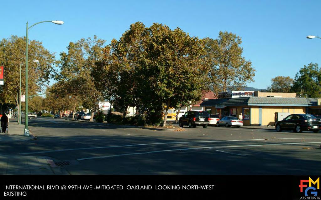
32 International Blvd and 99 th Ave
33

34
35 International Blvd and Durant Ave

36

37


38 BRT Timeline , Construction & Operations , Detailed Design 2012, Final Environmental Study We Are Here , Refine LPA , Draft Environmental Study 2001, Major Investment Study LPA Adopted
39 City of Oakland Bicycle and Pedestrian Facilities Program Bikeway Striping Projects Tracking page 1 of 3 last updated 4/12/2012 Street From To Length (miles) Bikeway Type Project Type Design (% complete) Feasibility BPAC Review AC Transit review Community Outreach Environmental clearance City Council approval Fund Source Paving Caltrans permit Implementation 104th Ave International Blvd Link St 0.4 3A new 100% x 2212 no n/a th Ave 2 Russett St International Blvd new 100% pave overlay n/a th St Oak St 2nd Ave new 100% x 5320 reconst n/a th St Mandela Pkwy Brush St new 100% x pave overlay n/a th Ave E 12th St Embarcadero new 100% x n/a 2162 no th/Ardley Aves 23rd Ave E 12th St 2.3 2/3B new 100% x 2162 no n/a nd St/Hollis St San Pablo Ave Emeryville 1.0 2/3B new 100% 2212 no th Ave E 18th St E 10th St 0.5 3B new 100% x n/a 2212 no n/a rd St/54th St San Pablo Ave Adeline St 0.5 3B new 100% x n/a 2609 no n/a th/Vicente/ Cavour Telegraph Ave Shafter Ave 0.3 3B new 100% x n/a 2609 no n/a th Ave International Blvd San Leandro St 0.6 3B new 100% x n/a street no n/a Alameda Ave Fruitvale Ave Howard St restripe 100% n/a x n/a n/a n/a n/a pave slurry n/a 2012 Broadway 1 22nd St I 580 overpass 1.0 2/3A restripe 100% n/a x n/a n/a n/a pave slurry 2012 Calaveras/Buell MacArthur Blvd MacArthur Blvd 0.2 2/3A new 100% x pave yes 2012 E 18th St Lakeshore Ave Park Blvd 0.2 3A new 100% x street no n/a 2012 Embarcadero Bridge Detour 2nd St / Oak St Embarcadero/ 5th Ave 1.4 2/3A new 100% x n/a 2211 no pending 2014 Foothill Blvd 2 23rd Ave Fremont Wy 1.9 3A new 100% x pave slurry n/a 2012 Genoa/52nd Sts Adeline St West St 0.7 3B new 100% x n/a 2212 no n/a 2012 Lakeshore Ave MacArthur Blvd Mandana Blvd 0.3 2/3A new 100% x 2214 yes 2013 Link St Bancroft Ave Sunnyside St new 100% x pave overlay n/a 2012 MacArthur Blvd High St Enos Ave 0.3 2/3A new 100% pave yes n/a 2012 MacArthur Blvd 5 Midvale Ave High St 0.6 3A new 100% x 2609 no n/a 2012 MacArthur/ Excelsior Park Blvd Ardley Ave 1.1 2/3A new 100% 2140 overlay n/a 2012 KEY [check] = completed n/a = not applicable BPAC = Bicycle Pedestrian Advisory Committee x = pending BPAC request Bikeway Type = 2 (bike lane), 3A/3B (sharrows)
40 City of Oakland Bicycle and Pedestrian Facilities Program Bikeway Striping Projects Tracking page 2 of 3 last updated 4/12/2012 Street From To Length (miles) Bikeway Type Project Type Piedmont Ave MacArthur Blvd Pleasant Valley Ave 0.7 2/3A new 100% x pave overlay n/a 2013 San Pablo Ave 16th St 32nd St 1.2 3A new 100% x pave slurry 2012 Telegraph Ave 1 16th St 20th St 0.2 2/3A new 100% n/a street no n/a Webster/ Shafter 29th St Berkeley 2.7 3B new 100% x n/a 2609 no th Ave 1 Edes Ave Russett St 0.3 2/3A new 90% x no n/a 10th St Oak St Kaiser 4th Ave 5th Ave new 90% x 2212 no n/a th St Emeryville border Webster St 0.8 3A new 90% preli m prelim prelim 2163 spot AC n/a 2013 Ardley/23rd Ave MacArthur Blvd E 30th St 0.3 2/3A new 90% x 2162 no pending 2012 Harrison St Grand Ave Fairmount Ave 0.3 3A new 90% x 2162 no n/a 2012 MacArthur Blvd Telegraph Ave Broadway 0.4 2/3A new 90% x n/a 2163 no n/a 2012 Shattuck Ave 45th St 55th St 0.5 2/3A new 90% x 2212 no 2013 Shattuck Ave 55th St Woolsey St new 90% x pave no n/a th St Kaiser Drive 4th Ave new 65% x 2212 no n/a Adeline St 47th St 61st St new 65% x n/a no n/a Alcatraz Ave Dover St College Ave 0.9 2/3A new 65% x n/a 2116 no n/a 2013 Broadway 38th St Broadway Ter 0.9 2/3A new 65% x pending pave no n/a 2013 College Ave Berkeley Broadway 1.0 3A new 65% x no E 12th St 2 14th Ave Fruitvale Ave 1.4 2/3A new 65% pending 2163 no n/a 2013 Harrison/ Lakeside Grand Ave Madison St new 65% 5320 n/a MacArthur Blvd Millsview Ave Seminary Ave new 65% x pave yes n/a th St Madison St Oak St new 35% x no n/a 8th St Harrison St Fallon St new 35% x n/a 9th St Harrison St Fallon St new 35% x n/a Broadway Broadway Ter Keith Ave 0.8 2/3A new 35% x prelim no Broadway/Caldec ott/tunnel Brookside Ave Berkeley new 35% x prelim 2140 no KEY [check] = completed n/a = not applicable BPAC = Bicycle Pedestrian Advisory Committee x = pending BPAC request Bikeway Type = 2 (bike lane), 3A/3B (sharrows) Design (% complete) Feasibility BPAC Review AC Transit review Community Outreach Environmental clearance City Council approval Fund Source Paving Caltrans permit Implementation
41 City of Oakland Bicycle and Pedestrian Facilities Program Bikeway Striping Projects Tracking page 3 of 3 last updated 4/12/2012 Street From To Length (miles) Bikeway Type Project Type Harrison/ Oakland Hamilton Pl Piedmont 1.1 2/3A new 35% x 2162 no 2013 Madison St Lakeside Dr 4th St new 35% x Oak St 14th St 4th St new 35% x 20th St San Pablo Ave Harrison St 0.5 2/3A new 15% x n/a 48th St Shattuck Ave Webster St 0.2 3B new 15% x n/a 2212 no n/a 2013 Adeline St 3rd St 36th St new 15% x Grand Ave Jean St El Embarcadero 0.7 2/3A new 15% x W Grand Ave Mandela Pkwy Market St new 15% x n/a Park Blvd E 18th St Excelsior Ave new 0% x Design (% complete) Feasibility BPAC Review AC Transit review Community Outreach Environmental clearance City Council approval Fund Source Paving Caltrans permit Implementation Design Completed (100%): 20.7 roadway miles Funding Design in Progress (15% 90%): 19.5 roadway miles 2116 US Department of Transportation Total: 40.2 roadway miles 2140 Caltrans (BTA, SR2S, or Caldecott settlement) 2162 TDA Article 3 Design Completion Color Coding 2163 MTC (SR2T or paving) 100% Plans packaged for construction Pending task 2166 BAAQMD 90% Review (field, internal, external) Priority task 2212 Measure B Ped/Bike Local (ACTIA) 65% Markings and details 2214 Measure B Ped/Bike Grant (ACTIA) 35% Lane configuration 2609 Federal Stimulus EECBG (DOE) 15% Project set up (limits, viewports, street widths) 5320 Measure DD pave Included in paving project street Included in streetscape project KEY [check] = completed n/a = not applicable BPAC = Bicycle Pedestrian Advisory Committee x = pending BPAC request Bikeway Type = 2 (bike lane), 3A/3B (sharrows)
42 City of Oakland Bicycle and Pedestrian Facilities Program Bikeway Signage Projects Tracking page 1 of 1 last updated 4/12/2012 Corridor From To 16th/Ardley Aves Embarcadero MacArthur Blvd % x 2162 $ 15, th/Bay/Hollis/32nd/San Pablo Grand Ave/Bay Pl & Emeryville % x n/a 2212/2162 $ 17, Broadway Corridor 14th St 41st St % x 2166 $ 13, MacArthur Blvd Lakeshore Ave Buell St % x n/a 2166 $ 29, Bay Trail (on street) Horton St High St % x n/a 2162 $ 41, Grand Ave Market St El Embarcadero % x n/a $ 10, Foothill/Bancroft Lakeshore Ave San Leandro % x n/a $ 42, Shattuck Ave/48th St Berkeley Telegraph/Webster % x $ 8, Harrison/Oakland Piedmont border Grand Ave % x $ 10, Design Completed (100%): 13.7 roadway miles Color Coding Design in Progress ( > 0%): 20.2 roadway miles Pending task Total ( > 0%): 33.9 roadway miles Priority task Length Design Design Status Work Completed Funding 100% Final work order 2140 Caltrans (BTA) 90% Final project map and installation locations 2162 TDA Article 3 75% Field verification 2163 Safe Routes to Transit (MTC) 55% Revised project map and field review sheet 2166 BAAQMD 35% Preliminary project map (sign locations, sign messages) 2212 Measure B Ped/Bike Local (ACTIA) 15% Overview map (project boundaries, supported destinations) 2230 State Gas Tax (CIP) 2609 Federal Stimulus (DOE) Future Projects (in priority order) Grizzly Peak / Skyline / Golf Links Berkeley Mountain Blvd % $ 85,680 Mountain/Shepherd Canyon Broadway Skyline Blvd 4.4 0% $ 24,640 Lakeshore/Lake Merritt Blvd (formerly Piedmont border Oak St 2.4 0% $ 13,440 E 18th St/4th/5th Aves Lakeshore Ave Embarcadero 1.1 0% $ 6,160 14th St Wood St 1st Ave 2.1 0% $ 11,760 KEY Design = % completed [checkmark] = completed n/a = not applicable prelim = preliminary BPAC = Bicycle Pedestrian Advisory Committee x = pending BPAC request BPAC Review Community Outreach Funding Source Cost Estimate Implementation
![[eb] Sibley [eb] Redwood Design Status of Bikeway Projects 19 April 2012 [eb] Roberts [eb] Redwood Skyline HS [eb] Chabot Montclair Merritt College UC Berkeley [eb] Lake Temescal Woodminster Holy](/docs-images/90/103725376/images/43-0.jpg "Names University Leona Heights Park [ba] Ashby [H] Alta Bates [ba] Rockridge Rockridge California College of the Arts Oakmore Glenview Laurel Mills College Millsmont Eastmont Castlemont HS Oakland")
43 [eb] Sibley [eb] Redwood Design Status of Bikeway Projects 19 April 2012 [eb] Roberts [eb] Redwood Skyline HS [eb] Chabot Montclair Merritt College UC Berkeley [eb] Lake Temescal Woodminster Holy Names University Leona Heights Park [ba] Ashby [H] Alta Bates [ba] Rockridge Rockridge California College of the Arts Oakmore Glenview Laurel Mills College Millsmont Eastmont Castlemont HS Oakland Zoo Oakland Tech HS Dimond Allendale Temescal [H] Children's [H] Kaiser Piedmont Ave Morcom Rose Garden Oakland HS Patten University Fairfax Elmhurst [am] Emeryville [ba] MacArthur [H] Summit Grand Lake [H] Highland Fremont HS [am] Coliseum [ba] San Leandro Parkway [ba] Fruitvale [ba] Coliseum Coliseum Sobrante Park McClymonds HS [ba] 19th St Old Oakland Laney College [ba] 12th St Oakland Museum [ba] Lake Merritt Chinatown Eastlake Embarcadero Cove Park Street Jack London Sq [am] Jack London [ba] West Oakland Oakland Ferry College of Alameda Bay Bridge Striping Status Signage Status Wayfinding Destinations Installed Installed [ba] Bart, [am] Amtrak, Oakland Airport Designed Designed District In Design In Design Park, [eb] Regional Park, Next Priorities Next Priorities Landmark, College, Other Proposed Bikeways [H] Hospital, or High School
PROJECT SPONSOR: The City of Oakland
 Grand Ave, MacArthur Blvd, Market St, and Telegraph Ave. The City s bicycle facilities include those within the jurisdiction of the Port of Oakland. The City s facilities also link to bicycle facilities
Minutes: A motion was made to approve minutes from both the July and August BPAC meetings. That motion was approved.
 Oakland BPAC 9/20/12 Attendees: Ann Killebrew, Carol Levine, Chris Hwang, Chris Kidd, Dave Campbell, Jason Patton, Jennifer Stanley, Liza Pratt, Midori Tabata, Robert Prinz, Ryan Chan, Tom Willging, Ade
Oakland Bicycle and Pedestrian Advisory Committee, September 19, 2013 Meeting
 Oakland Bicycle and Pedestrian Advisory Committee, September 19, 2013 Meeting Attendees: Brian Toy, Chris Hwang, Chris Kidd, Daniel Schulman, Dave Campbell, Jason Patton, Jennifer Stanley, Midori Tabata,
City of Oakland, Bicycle and Pedestrian Advisory Committee, Monthly Meeting
 City of Oakland, Bicycle and Pedestrian Advisory Committee, Monthly Meeting Thursday October 17, 2013 meeting Attendees: Jennifer Anderson Jenna Burton Dave Campbell, East Bay Bicycle Coalition Jeffrey
Item B1 November 19, 2009
 November 19, 2009 Planning and Development Department Land Use Planning Division DATE: November 19, 2009 STAFF REPORT TO: FROM: SUBJECT: Members of the Transportation Commission Elizabeth Greene Senior
HARRISON STREET/OAKLAND AVENUE COMMUNITY TRANSPORTATION PLAN
 HARRISON STREET/OAKLAND AVENUE Community Workshop #4: Draft Plan Review December 3, 2009 D E S I G N, C O M M U N I T Y & E N V I R O N M E N T INTRODUCTIONS Key Project Staff: Alisa Shen, Project Manager,
Chapter 6 Implementation Plan
 Chapter 6 Implementation Plan Walking is the oldest and most basic form of human transportation. It requires no fare, no fuel, no license, and no registration. With the exception of devices to enhance
Item Description: Presentation and Discussion: Berkeley Rapid Transit Locally Preferred Alternative
 Office of the City Manager Meeting Date: April 29, 2010 Item Number: 1 Item Description: Presentation and Discussion: Berkeley Rapid Transit Locally Preferred Alternative Staff report, resolution, and
Geary Corridor Bus Rapid Transit SFMTA Citizens Advisory Committee
 Geary Corridor Bus Rapid Transit SFMTA Citizens Advisory Committee Project Update SAN FRANCISCO COUNTY TRANSPORTATION AUTHORITY SAN FRANCISCO MUNICIPAL TRANSPORTATION AGENCY August 6, 2015 Project Overview
Broad Street Bicycle Boulevard Design Guidelines
 Broad Street Bicycle Boulevard Design Guidelines Building from the strategies introduced in the 2013 Bicycle Transportation Plan and community input received thus far, City Transportation Staff have identified
Community Task Force November 15, 2017
 Community Task Force November 15, 2017 Welcome and Introductions Project Partners Regional Transportation District (RTD) Colorado Department of Transportation (CDOT) Denver Regional Council of Governments
5:30 1 Introductions, appointment of note taker (5 minutes) Ad
 Ad") CITY OF OAKLAND DALZIEL BUILDING. 250 FRANK H. OGAWA PLAZA. SUITE 4344. OAKLAND. CALIFORNIA. 94612 Public Works Agency TEL: (510) 238-3466 Infrastructure Plans and Programming Division FAX: (510) 238-7415
CITY OF OAKLAND DALZIEL BUILDING. 250 FRANK H. OGAWA PLAZA. SUITE 4344. OAKLAND. CALIFORNIA. 94612 Public Works Agency TEL: (510) 238-3466 Infrastructure Plans and Programming Division FAX: (510) 238-7415
Telegraph Avenue Complete Streets DRAFT Recommendations. Oakland Public Works Department September 11 and 13, 2014 Open Houses
 Telegraph Avenue Complete Streets DRAFT Recommendations Oakland Public Works Department September 11 and 13, 2014 Open Houses Presentation Overview What are complete streets? What problem are we trying
Bicycle and Pedestrian Advisory Committee (BPAC) November 21, 2013
 November 21, 2013") Bicycle and Pedestrian Advisory Committee (BPAC) November 21, 2013 OVERALL LAND USE CONCEPT Overall Broadway Valdez District: 95.5 acres (35.1 acres right-of ways + 60.4 acres developable land) Plan Subareas:
Bicycle and Pedestrian Advisory Committee (BPAC) November 21, 2013 OVERALL LAND USE CONCEPT Overall Broadway Valdez District: 95.5 acres (35.1 acres right-of ways + 60.4 acres developable land) Plan Subareas:
Notes from BPAC Meeting January 20, 2011
 tes from BPAC Meeting January 20, 2011 Attendees: Brian Toy, Chris Hwang, Dave Campbell, Jason Patton, Jennifer Stanley, Jonathan Bair, Kassie Rohrbach, Rebecca Saltzman, Rick Rickard, Robert Raburn, Ron
Technical Working Group November 15, 2017
 Technical Working Group November 15, 2017 Welcome and Introductions Project Partners Regional Transportation District (RTD) Colorado Department of Transportation (CDOT) Denver Regional Council of Governments
Approval of Meeting Minutes: The September minutes were approved.
 Bicycle and Pedestrian Advisory Committee, Monthly Meeting Thursday, October 18, 2012; 5:30 7:30 pm Oakland City Hall, Sgt Daniel Sakai Hearing Room (aka Hearing Room 4), Second Floor Attendees: Ann Killebrew,
Mission-Geneva Transportation Study Community Workshop 2 July 8, 2006
 Community Workshop 2 July 8, 2006 Small Group Workbook 1 Basic Improvements on Mission Street Streetscape. Pedestrian-scale lighting; landscaping; community art on utility boxes; more (possibly unique)
TRAFFIC ACTION PLAN. Laurie Meadows Neighborhood CITY OF SAN MATEO
 TRAFFIC ACTION PLAN Laurie Meadows Neighborhood CITY OF SAN MATEO Draft January 2017 Table of Contents Introduction... 2 The Traffic Forum Process... 5 Neighborhood Traffic Issues... 7 Neighborhood Recommendations
SAN FRANCISCO MUNICIPAL TRANSPORTATION AGENCY
 THIS PRINT COVERS CALENDAR ITEM NO. : 10.2 DIVISION: Sustainable Streets BRIEF DESCRIPTION: SAN FRANCISCO MUNICIPAL TRANSPORTATION AGENCY Adopting Conceptual Proposal for Streetscape Improvements to Broadway,
Tonight is for you. Learn everything you can. Share all your ideas.
 Strathcona Neighbourhood Renewal Draft Concept Design Tonight is for you. Learn everything you can. Share all your ideas. What is Neighbourhood Renewal? Creating a design with you for your neighbourhood.
San Pablo High Treatment applied incrementally at each N + ++
 Transit Improvements T1 Further study options for creation or designation of segregated transit lanes along San Pablo, including options for restrictions during a limited number of peak travel hours and
Freeway ramp intersection study
 Freeway ramp intersection study Supporting Vision Zero: Zero traffic deaths in San Francisco by 2024 Study Goals: Primary Improve Safety Improve Accessibility Secondary Provide Efficient Circulation Accommodate
Community Task Force March 14, 2018
 Community Task Force March 14, 2018 Welcome and Introductions Project Partners Regional Transportation District (RTD) City of Aurora Colorado Department of Transportation (CDOT) Denver Regional Council
Arterial Transitway Corridors Study. Ave
 Arterial Transitway Corridors Study Ave January 2012 Arterial Transitway Corridors Study Overview Corridor Features and Demographics 11 study corridors, 95 route miles 86,000 daily rides and half of existing
Welcome! Thank you for joining us today for a Geary Rapid project open house. Geary Rapid Project. SFMTA.com/GearyRapid
 Welcome! Thank you for joining us today for a Geary Rapid project open house. Get the most out of this event: 1. Sign in and get your feedback sheet 2. Visit project information stations hosted by project
Geary Corridor Bus Rapid Transit
 Geary Corridor Bus Rapid Transit Near-term Improvements Update SAN FRANCISCO COUNTY TRANSPORTATION AUTHORITY SAN FRANCISCO MUNICIPAL TRANSPORTATION AGENCY Phasing Packages Phase 1 Near-term: Delivers project
Caltrans Sloat Boulevard Pedestrian Safety Project Response to Community Questions, Comments & Concerns
 Caltrans Sloat Boulevard Pedestrian Safety Project Response to Community Questions, Comments & Concerns Revised: May 10, 2016 The California Department of Transportation (Caltrans) is planning various
East 12 th Street Bikeway Feasibility Study
 Final Report East 12 th Street Bikeway Feasibility Study Prepared for: City of Oakland Public Works Agency Submitted by: 180 Grand Avenue, Suite 250 Oakland, CA 94612 Phone: (510) 839-1742; Fax: (510)
Watertown Complete Streets Prioritization Plan. Public Meeting #1 December 14, 2017
 Watertown Complete Streets Prioritization Plan Public Meeting #1 December 14, 2017 Goals for Public Meeting Overview of MassDOT Complete Streets Funding Program Educate the community on Complete Streets
LAUREL HEIGHTS/JORDAN PARK TRAFFIC CALMING PROJECT DECEMBER 2012
 LAUREL HEIGHTS/JORDAN PARK TRAFFIC CALMING PROJECT DECEMBER 2012 PREPARED BY: SAN FRANCISCO MUNICIPAL TRANSPORTATION AGENCY TRAFFIC CALMING PROGRAM 1 SOUTH VAN NESS AVENUE SAN FRANCISCO, CA 94103 Preparation
PROJECT OVERVIEW. 20th Avenue Project Limits (Lincoln Way to Wawona St)
") PROJECT OVERVIEW In 2014, San Francisco adopted Vision Zero as City policy, with a commitment to eliminate all traffic deaths in the City by 2024. nue Project Limits (Lincoln Way to St) Collision data
PROJECT OVERVIEW In 2014, San Francisco adopted Vision Zero as City policy, with a commitment to eliminate all traffic deaths in the City by 2024. nue Project Limits (Lincoln Way to St) Collision data
BRT for Berkeley A Proposal for Consideration
 BRT for Berkeley A Proposal for Consideration CITY OF BERKELEY STAFF PROPOSAL FOR A LOCALLY PREFERRED ALTERNATIVE OF THE EAST BAY BUS RAPID TRANSIT PROJECT SEPTEMBER 8, 2009 Table of Contents Executive
Oakland Pedestrian Master Plan Oakland Pedestrian Plan Draft Recommendations Chapter Outline
 EISEN LETUNIC T R A N S P O R T A T I O N, ENVIRO N M E N TA L A N D URBAN PLANNIN G MEMORANDUM To Oakland Pedestrian Plan Technical Advisory Committee & Pedestrian Advisory Group From Victoria Eisen Date
THE ALAMEDA CONCEPT DESIGN COMMUNITY MEETING 3. A Plan for The Beautiful Way JANUARY 28, 2010
 CONCEPT DESIGN COMMUNITY MEETING 3 JANUARY 28, 2010 AGENDA INTRODUCTION COMMUNITY INPUT ROADWAY STUDIES STREETSCAPE DESIGN STATIONS DISCUSSION SUMMARY AND DISCUSSION NEXT STEPS CLOSE INTRODUCTION SCHEDULE
MOBILITY WORKSHOP. Joint City Council and Transportation Commission May 5, 2014
 MOBILITY WORKSHOP Joint City Council and Transportation Commission May 5, 2014 Review of General Plan M-1 Develop world-class transit system M-3 Maintain/enhance pedestrian-oriented City M-4 Create comprehensive
Draft Traffic Calming Policy Paper
 Draft Traffic Calming Policy Paper What is Traffic Calming The term traffic calming is defined differently throughout the United States. The Institute of Transportation Engineers, an international educational
Appendix C. TRAFFIC CALMING PROGRAM TOOLBOX
 Appendix C. TRAFFIC CALMING PROGRAM TOOLBOX PHASE I...2 Do Not Enter Sign...3 One-Way Sign...4 Turn Prohibition...5 Pavement Markings...6 Speed Monitoring Trailer...7 Neighborhood Speed Watch...8 Police
Omaha s Complete Streets Policy
 Omaha s Complete Streets Policy (Adopted August 2015) VISION To create great places and enhance our quality of life, the City of Omaha will provide safe, accessible streets for all users. Complete Streets
Project Goal and Description. Why Broadway? Broadway SFMTA.COM/BROADWAY. The goal of the Broadway Safety Improvement
 PROJECT OVERVIEW Project Goal and Description The goal of the Broadway Safety Improvement d St Van Ness Ave Project is to improve safety and comfort for all who Franklin St Hyde St Octavia St Gough St
EL CAMINO REAL BUS RAPID TRANSIT (BRT) PROJECT
 PROJECT") Agenda Item #4.2 EL CAMINO REAL BUS RAPID TRANSIT (BRT) PROJECT VTA BOARD WORKSHOP MAY 1, 2015 ABOUT THIS PRESENTATION CONTEXT Existing conditions and planning for growth WHAT IS THE PROJECT? Project alternatives
Agenda Item #4.2 EL CAMINO REAL BUS RAPID TRANSIT (BRT) PROJECT VTA BOARD WORKSHOP MAY 1, 2015 ABOUT THIS PRESENTATION CONTEXT Existing conditions and planning for growth WHAT IS THE PROJECT? Project alternatives
MINERAL AVENUE CORRIDOR ASSESSMENT STUDY IMPLEMENTATION STRATEGY
 MINERAL AVENUE CORRIDOR ASSESSMENT STUDY IMPLEMENTATION STRATEGY INTRODUCTION City Personnel Sign-in Sheet Comment Forms Please Write Down Any Feedback INTRODUCTION List of Topics for Presentation Study
BETHEL ROAD AND SEDGWICK ROAD CORRIDOR STUDY
 DRAFT PLAN City Council Meeting August 14, 2017 STUDY AREA Sedgwick Corridor State Route 160, principal arterial with Class 3 access management designation, commuter and freight route, connection to SR
FOLSOM-HOWARD STREETSCAPE OVERVIEW
 FOLSOM-HOWARD STREETSCAPE OVERVIEW SoMa residents should have the same kinds of amenities that other neighborhoods have. The Folsom- Howard Streetscape Project will make SoMa more livable by making it
San Jose Transportation Policy
 San Jose Transportation Policy Protected Intersections in LOS Policies to Support Smart Growth Presented by: Manuel Pineda City of San Jose Department of Transportation Bay Area Map San Francisco Oakland
TRAFFIC ACTION PLAN. North Central Neighborhood CITY OF SAN MATEO
 TRAFFIC ACTION PLAN North Central Neighborhood CITY OF SAN MATEO Draft February 2017 Table of Contents Introduction... 1 The Traffic Forum Process... 4 Neighborhood Traffic Issues... 6 Neighborhood Recommendations
Mission Bay Loop (MBL) Public Meeting
 Public Meeting") Mission Bay Loop (MBL) Public Meeting La Scuola Internazionale di San Francisco, November 18, 2014 Frequently Asked Questions 1. When would construction have to start before the SFMTA loses TIGER funds?
Mission Bay Loop (MBL) Public Meeting La Scuola Internazionale di San Francisco, November 18, 2014 Frequently Asked Questions 1. When would construction have to start before the SFMTA loses TIGER funds?
Outreach Approach RENEW SF served as the primary liaison with the North Beach community; the Chinatown. Executive Summary
 Executive Summary Executive Summary The Columbus Avenue Neighborhood Transportation Study s objective is to identify changes to transportation infrastructure and policies that could enhance the livability
California Department of Transportation, District 4. Sloat Boulevard Project Skyline Blvd. to 19 th Ave. Community Update January 13, 2016
 California Department of Transportation, District 4 Sloat Boulevard Project Skyline Blvd. to 19 th Ave. Community Update January 13, 2016 Agenda Welcome and introductions Project overview, history and
Chapter 3: Multi-Modal Circulation and Streetscapes
 CHAPTER 3: MULTI-MODAL CIRCULATION AND STREETSCAPES Chapter 3: Multi-Modal Circulation and Streetscapes Overview Streetscape improvements have already been completed for Depot Street between Main Avenue
UPTOWN REGIONAL BIKE CORRIDORS PROJECT SAN DIEGO ASSOCIATION OF GOVERNMENTS
 UPTOWN REGIONAL BIKE CORRIDORS PROJECT SAN DIEGO ASSOCIATION OF GOVERNMENTS SUMMARY REPORT: COMMUNITY UPDATE MEETING February 6, 2014 6 8:30 p.m. Roosevelt Middle School Library 3366 Park Blvd, San Diego
TRAFFIC CALMING GUIDE FOR TORONTO CITY OF TORONTO TRANSPORTATION SERVICES DIVISION
 TRAFFIC CALMING GUIDE FOR TORONTO CITY OF TORONTO TRANSPORTATION SERVICES DIVISION CITY OF TORONTO TRANSPORTATION SERVICES DIVISION 2016 TRAFFIC CALMING GUIDE FOR TORONTO TABLE OF CONTENTS Introduction
City of Sammamish. Welcome. Issaquah-Fall City Road Improvements Project Phase I Design: 242nd Avenue SE to Klahanie Drive SE
 Welcome Welcome to the third community meeting for the Issaquah-Fall City Road Improvements Project. AGENDA 6:00 p.m. Welcome and sign-in 6:10 p.m. Presentation 6:50 p.m. Open house Learn about the roadway
BD RESOLUTION NO RESOLUTION ADOPTING THE VISION ZERO RAMP INTERSECTION STUDY PHASE 1
 BD00 RESOLUTION NO. - RESOLUTION ADOPTING THE VISION ZERO RAMP INTERSECTION STUDY PHASE [NTIP PLANNING] FINAL REPORT WHEREAS, The Vision Zero Ramp Intersection Study Phase was recommended by Commissioner
Active Transportation Facility Glossary
 Active Transportation Facility Glossary This document defines different active transportation facilities and suggests appropriate corridor types. Click on a facility type to jump to its definition. Bike
Bike San Mateo County San Mateo County Bicycle Plan Recommendations August 30, 2010
 Policy and Procedures Develop and Implement a Complete Streets Policy to comply with DD-64-R1 and AB1358 Commencing January 1, 2011, AB1358 requires that the legislative body of a city or county, upon
CITY OF OAKLAND. 27th Street Bikeway Feasibility and Design. Final Report (v3) March 23, Kimley-Horn and Associates, Inc.
 March 23, Kimley-Horn and Associates, Inc.") CITY OF OAKLAND 27th Street Bikeway Feasibility and Design Final Report (v3) March 23, 2007 PREPARED BY: Kimley-Horn and Associates, Inc. Table of Contents 1. Introduction 3 2. 27 th Street/Bay Place Corridor
CITY OF OAKLAND 27th Street Bikeway Feasibility and Design Final Report (v3) March 23, 2007 PREPARED BY: Kimley-Horn and Associates, Inc. Table of Contents 1. Introduction 3 2. 27 th Street/Bay Place Corridor
M14A/D Select Bus Service
 M14A/D Select Bus Service Manhattan Community Board 6: April 1, 2019 New York City Transit 2 Background M14 Select Bus Service M14 was identified as a critical future SBS corridor in past BRT studies as
TOWN OF MORAGA MORAGA WAY AND CAMINO PABLO/CANYON ROAD IMPROVEMENTS Town Council Meeting March 13, 2019
 TOWN OF MORAGA MORAGA WAY AND CAMINO PABLO/CANYON ROAD IMPROVEMENTS Town Council Meeting March 13, 2019 1 Edric Kwan, Public Works Director Josh Peterman, Principal, Fehr and Peers Shawn Knapp, Senior
What Is a Complete Street?
 Session 5 Charleen Zimmer, AICP, Zan Associates May 5-7, 2010 What Is a Complete Street? May 2010 5-1 Not a Complete Street More of a Complete Street May 2010 5-2 Benefits of Complete Streets Safety for
WELCOME. Thank you for joining us at the Second Public Workshop for the Carlsbad Pedestrian Master Plan. We look forward to receiving your feedback.
 City of Carlsbad Pedestrian Master Plan: WELCOME WELCOME Please Sign In Provide Input at Flip Charts Review Boards Presentation of Draft Plan Thank you for joining us at the Second Public Workshop for
EBOTS Phase 2 Outreach Summary
 EBOTS Phase 2 Outreach Summary Introduction The Emeryville-Berkeley-Oakland Transit Study (EBOTS) project team conducted several outreach activities between March 2014 and May 2014 to evaluate ideas for
TELEGRAPH AVENUE COMPLETE STREETS PLAN DRAFT FINAL PLAN
 TELEGRAPH AVENUE COMPLETE STREETS PLAN DRAFT FINAL PLAN SEPTEMBER 2014 TABLE OF CONTENTS Executive Summary...1 Project Purpose and Need...5 Analysis of Street Design Options...11 Recommended Project...17
5. RUNNINGWAY GUIDELINES
 5. RUNNINGWAY GUIDELINES These guidelines should be considered collectively when making runningway decisions. A runningway is the linear component of the transit system that forms the right-of-way reserved
Frequently Asked Questions (FAQ)
") Frequently Asked s (FAQ) Study Process... 2 Rapid Transit Service and Operations... 5 Public Consultation... 8 Business Impacts... 8 Design and Property Impacts... 9 Construction Impacts...12 Traffic,
Frequently Asked s (FAQ) Study Process... 2 Rapid Transit Service and Operations... 5 Public Consultation... 8 Business Impacts... 8 Design and Property Impacts... 9 Construction Impacts...12 Traffic,
Clay Street Bridge Replacement Project
 Clay Street Bridge Replacement Project Frequently Asked Questions (FAQs) The project is located in downtown Placerville on Clay Street between US Highway 50 and Main Street and Cedar Ravine Road. The proposed
Berkeley Strategic Transportation Plan A-76
 Berkeley Strategic Transportation Plan A-76 Appendices 1. A Team Effort 2. Where We ve Been A-11 Berkeley Strategic Transportation Plan Alameda County Transportation Plan Alameda County will be served
A. Caltrans BTA Requirements
 A. Caltrans BTA Requirements To be eligible for funding from the State s Bicycle Transportation Account (BTA), local agencies must have an adopted Bicycle Transportation Plan that was approved by the Regional
PRESS RELEASE San Joaquin Council of Governments
 PRESS RELEASE San Joaquin Council of Governments For Immediate Release February 23, 2018 Contact: Nicole Gorham, 235-0582 gorham@sjcog.org SJCOG Board Awards $19.63 Million in Measure K Bicycle, Pedestrian,
TRAFFIC CALMING TOOLBOX
 TRAFFIC CALMING TOOLBOX Traffic control devices are those official signs and striping placed in the public right-of-way and recognized by the public such as STOP signs, curve warning signs, centerline
Proposed. City of Grand Junction Complete Streets Policy. Exhibit 10
 Proposed City of Grand Junction Complete Streets Policy Exhibit 10 1 City of Grand Junction Complete Streets Policy Vision: The Complete Streets Vision is to develop a safe, efficient, and reliable travel
Item No. 14 Town of Atherton
 Item No. 14 Town of Atherton CITY COUNCIL STAFF REPORT CONSENT AGENDA TO: THROUGH: FROM: HONORABLE MAYOR AND CITY COUNCIL GEORGE RODERICKS, CITY MANAGER MICHAEL KASHIWAGI, COMMUNITY SERVICES DIRECTOR MARTY
Mineral Avenue Corridor Assessment. ITE 2017 Western District Annual Meeting San Diego, CA June 21 st
 Mineral Avenue Corridor Assessment ITE 2017 Western District Annual Meeting San Diego, CA June 21 st Biography - Aaron Heumann, PE, PTOE Currently City of Littleton Transportation Engineering Manager 24
Dr. M.L. King, Jr. Street North Complete Streets Resurfacing Opportunities HOUSING, LAND USE, AND TRANSPORTATION COMMITTEE MARCH 22, 2018
 Dr. M.L. King, Jr. Street North Complete Streets Resurfacing Opportunities HOUSING, LAND USE, AND TRANSPORTATION COMMITTEE MARCH 22, 2018 What s Happening The City plans to mill and resurface Dr. M.L.
25th Avenue Road Diet Project A One Year Evaluation. Transportation Fund for Clean Air Project #05R07
 25th Avenue Road Diet Project A One Year Evaluation Transportation Fund for Clean Air Project #05R07 Submitted by: The San Francisco Municipal Transportation Agency Dan Provence May 22, 2009 EXECUTIVE
9/25/2018. Multi-Modal Level of Service (MMLOS) Bianca Popescu, Transportation Planner
 Bianca Popescu, Transportation Planner") Multi-Modal Level of Service (MMLOS) Bianca Popescu, Transportation Planner 1 What is MMLOS? Is this a nice place to walk? Is this a nice place to bike? Is transit convenient? Bottom line - Are there options
Multi-Modal Level of Service (MMLOS) Bianca Popescu, Transportation Planner 1 What is MMLOS? Is this a nice place to walk? Is this a nice place to bike? Is transit convenient? Bottom line - Are there options
5:30 1 Introductions, appointment of note taker (5 minutes) Ad
 Ad") DALZIEL BUILDING. 250 FRANK H. OGAWA PLAZA. SUITE 4344. OAKLAND. CALIFORNIA. 94612 Public Works Agency TEL: (510) 238-3466 Transportation Planning & Funding Division FAX: (510) 238-7415 Bicycle and Pedestrian
DALZIEL BUILDING. 250 FRANK H. OGAWA PLAZA. SUITE 4344. OAKLAND. CALIFORNIA. 94612 Public Works Agency TEL: (510) 238-3466 Transportation Planning & Funding Division FAX: (510) 238-7415 Bicycle and Pedestrian
EL CAMINO REAL BUS RAPID TRANSIT PROJECT
 EL CAMINO REAL BUS RAPID TRANSIT PROJECT Would upgrade the current 522 Rapid Bus to BRT status by making changes to El Camino Real and The Alameda that make transit FAST, FREQUENT AND RELIABLE and make
4 MOBILITY PLAN. Mobility Plan Objectives. Mobility Context. 1. Integrate with Local and Regional Transit Improvements
 Harbor Mixed Use CHAPTER Transit Corridor 4: Mobility Plan 4 MOBILITY PLAN Mobility Plan Objectives The Harbor Corridor Plan seeks to expand and improve the ways that people move along and through the
Geary Bus Rapid Transit Project
 Geary Bus Rapid Transit Project Outreach Update SAN FRANCISCO COUNTY TRANSPORTATION AUTHORITY SAN FRANCISCO MUNICIPAL TRANSPORTATION AGENCY April 28, 2016 Project Activities Since January Meeting Continued
AGENDA ITEM G-2 Public Works
 AGENDA ITEM G-2 Public Works STAFF REPORT City Council Meeting Date: 12/6/2016 Staff Report Number: 16-214-CC Regular Business: Approve the Oak Grove University Crane Bike Improvement Concept Plan, authorize
City of Oakland - Department of Transportation
 MEASURE B AND MEASURE BB Annual Program Compliance Report Reporting Fiscal Year 206-207 AGENCY CONTACT INFORMATION Agency Name: City of Oakland - Department of Transportation Date: 2/22/207 Primary Point
City of Vallejo Traffic Calming Toolbox
 City of Vallejo Traffic Calming Toolbox June 1, 2013 Final Table of Contents Introduction... 1 Non-Physical Devices... 3 High-Visibility Crosswalk... 3 In Pavement Lighted Crosswalk... 4 Rapid Flashing
Introduction. North 12 th Complete Street Project Overview
 Introduction On Wednesday, March 1, 2017, the City of Sacramento, in partnership with Sacramento Regional Transit District and the Sacramento Housing and Redevelopment Agency, hosted a community outreach
REGIONAL BICYCLE AND PEDESTRIAN DESIGN GUIDELINES
 REGIONAL BICYCLE AND PEDESTRIAN DESIGN GUIDELINES November 16, 2011 Deb Humphreys North Central Texas Council of Governments Bicycle and Pedestrian Advisory Committee Snapshot of the Guide 1. Introduction
Brooklyn Boulevard (County Road 152) Reconstruction Project Phase I. OPEN HOUSE June 20, 2017
 Reconstruction Project Phase I. OPEN HOUSE June 20, 2017") Brooklyn Boulevard (County Road 152) Reconstruction Project Phase I OPEN HOUSE June 20, 2017 Brooklyn Boulevard (County Road 152) Phase I Project Partners Project Lead Other Project Partners include Brooklyn
Brooklyn Boulevard (County Road 152) Reconstruction Project Phase I OPEN HOUSE June 20, 2017 Brooklyn Boulevard (County Road 152) Phase I Project Partners Project Lead Other Project Partners include Brooklyn
Downtown Naples Mobility and Connectivity Study. Naples City Council Presentation January 2017
 Downtown Naples Mobility and Connectivity Study Naples City Council Presentation January 2017 Agenda 1. Introduction 2. Scope Review 3. Project Schedule 4. Existing Conditions 5. Public Charrette 6. Mobility
CITY OF LANCASTER PROPOSED NEW PROJECTS
 CITY OF LANCASTER 2013-2014 PROPOSED NEW PROJECTS Project Code 11 Facilities and Fixtures Project Title 1 11BS018 Main. Yard Storage Bldg, Phase 2 2 11GS007 Parks Improvements 3 11GS008 Dog Park AHP 4
CRESTON ROAD COMPLETE AND SUSTAINABLE STREETS CORRIDOR PLAN
 CRESTON ROAD COMPLETE AND SUSTAINABLE STREETS CORRIDOR PLAN Preferred Plan Community Presentation September 27, 2017 City of El Paso de Robles in partnership with: Local Government Commission, W-Trans,
Governance and Priorities Committee Report For the July 2, 2015 Meeting
 CITY OF VICTORIA For the July 2, 2015 Meeting To: Governance and Priorities Committee Date: From: Subject: Brad Dellebuur, A/Assistant Director, Transportation and Parking Services Executive Summary The
Southview Blvd & 3 rd Avenue Improvement Project. Public Open House December 4, to 7pm
 Southview Blvd & 3 rd Avenue Improvement Project Public Open House December 4, 2014 5 to 7pm Southview Blvd & 3 rd Avenue Public Information Meeting Agenda Presentation 5:30 to 6:15 pm Purpose of Project
4. ENVIRONMENTAL IMPACT ANALYSIS 9. TRANSPORTATION AND TRAFFIC
 4. ENVIRONMENTAL IMPACT ANALYSIS 9. TRANSPORTATION AND TRAFFIC 4.9.1 INTRODUCTION The following section addresses the Proposed Project s impact on transportation and traffic based on the Traffic Study
SAN FRANCISCO MUNICIPAL TRANSPORTATION AGENCY
 THIS PRINT COVERS CALENDAR ITEM NO. : 11 DIVISION: Sustainable Streets BRIEF DESCRIPTION: SAN FRANCISCO MUNICIPAL TRANSPORTATION AGENCY Approving traffic modifications on Twin Peaks Boulevard between Christmas
Safe Streets. City of Lake Forest Park. March 21, 2017
 Safe Streets City of Lake Forest Park March 21, 2017 1 01 WELCOME 2 Agenda WELCOME WHAT IS THIS PROJECT? CONTEXT DRAFT CITYWIDE PROJECTS EXERCISE INTRODUCTION 3 02 WHAT IS THIS PROJECT? 4 WHAT IS THIS
Bluffdale/ UDOT South High-T Intersection Project Type Operations
 Bluffdale/ UDOT 14600 South High-T Intersection Project Type Operations 14600 South and Redwood Road $ 600,000 $ 550,000 This project is to install a new High-T intersection at Redwood Road and 14600 South
MEASURE B AND MEASURE BB Annual Program Compliance Report Reporting Fiscal Year AGENCY CONTACT INFORMATION
 MEASURE B AND MEASURE BB Annual Program Compliance Report Reporting Fiscal Year 2016-2017 AGENCY CONTACT INFORMATION Agency Name: City of Livermore Date: 12/4/2017 Primary Point of Contact Name: Debbie
AGENDA. 6:00 1 Roll Call/Determination of Quorum/Introductions (5 minutes)
") CITY OF OAKLAND DALZIEL BUILDING. 250 FRANK H. OGAWA PLAZA. SUITE 4344. OAKLAND. CALIFORNIA. 94612 Public Works Department TEL: (510) 238-3466 Transportation Planning & Funding Division FAX: (510) 238-7415
CITY OF OAKLAND DALZIEL BUILDING. 250 FRANK H. OGAWA PLAZA. SUITE 4344. OAKLAND. CALIFORNIA. 94612 Public Works Department TEL: (510) 238-3466 Transportation Planning & Funding Division FAX: (510) 238-7415
Eliminate on-street parking where it will allow for a dedicated bus only lane %
 Traffic Dashboard Priorities Survey Responses Introduction 1) Are you familiar with bus rapid transit (BRT)? a. No, BRT is new to me. 597 23.5% b. I ve heard of BRT, but I don t know much about it. 1,136
Giles Run Connector Road
 Giles Run Connector Road Laurel Hill Adaptive Reuse Area to Laurel Crest Drive South County Federation Meeting June 14, 2016 History Connector road included in the Laurel Hill Comprehensive Plan amendment
City of Elizabeth City Neighborhood Traffic Calming Policy and Guidelines
 City of Elizabeth City Neighborhood Traffic Calming Policy and Guidelines I. Purpose: The City of Elizabeth City is committed to ensure the overall safety and livability of residential neighborhoods. One