SECTION V - CIRCULATION PLAN ELEMENT
|
|
|
- Jack Conley
- 6 years ago
- Views:
Transcription
1 INTRODUCTION SECTION V - CIRCULATION PLAN ELEMENT As a community that is essentially fully-developed, Livingston s transportation improvement opportunities are limited. The primary mode of transportation within the Township, and for those traveling to or from the Township, is the private motor vehicle. There is no rail service, and there is no land available for a rail right-of-way that would provide direct or connecting commuter service. Limited bus services provide east-west inter-community carriage within New Jersey and on commuter routes to and from New York City. The focus of this Circulation Element is upon in-town vehicle and pedestrian safety, parking, and bicycling. ROADWAY SYSTEM Roadways are classified into a hierarchy based upon their intended and actual function. Table V-1 defines the different roadway classifications, and identifies roadways, within each classification other than Local, that serve the Township. Table V-1: Roadway Classification I stands for Interstate; Route for a State Highway; and, CR for an Essex County Road. Classification Definition Roadways Freeway Limited access; accommodates I-0 inter-state travel. Major Arterial Serves inter-regional and intercommunity travel Livingston Avenue (CR ; CR ) Mt. Pleasant Avenue (Route ) Northfield Road (CR 0) South Orange Avenue (CR ) JFK Parkway (CR ) Eisenhower Parkway (CR 0) Minor Arterial Also serves inter-community travel, but at a lower level of mobility than principal arterials Walnut Street (CR 0) Passaic Avenue (CR 0) Shrewsbury Drive (CR ) Laurel Avenue (CR ) Collector Collects traffic from local roadways, Cedar Street (CR ) and distributes to arterial roadways Hobart Gap Road (CR 0) Beaufort Avenue (CR 1) Local Provides direct access to all land uses All other roadways Section V 1
2 East-West Traffic Interstate 0, the roadway in western Essex County with the highest classification, runs eastwest along the portion of the Township s northern border that lies between Livingston Avenue and Laurel Avenue. On and off ramps are provided at both of those avenues; although most of the interchange ramps between Livingston Avenue and I-0 lie in Roseland Borough. After leaving the Township, Eisenhower Parkway also connects to I-0 at an interchange with ramps in Roseland Borough. A number of major regional roadways cross the Township. State Route (Mount Pleasant Avenue) is a key east-west route for commuters traveling between the New York City metropolitan area and western Essex County, Morris County and beyond. South Orange Avenue (CR ) and Northfield Road (CR 0) are east-west roadways that extend to the east through southern Essex County. South Orange Avenue continues westward into Morris County. Northfield Road s western terminus is at the Route Livingston Circle. North-South Traffic Livingston Avenue (CR and ), continues as John F. Kennedy Parkway for its portion that is south of South Orange Avenue and is the highest use north-south roadway in the Township. A major portion of its traffic is vehicles moving between I-0 to the north and Route to the south. It also is a major location of offices, retail properties, banks, and the Civic Center Municipal Complex housing Town Hall, Police Headquarters, the Library and the High School. Eisenhower Parkway (CR 0) is vital to north-south traffic mobility on the westerly side of the Township. However, it is a relatively short roadway that runs only between South Orange Avenue and I-0 in Roseland. If it were extended to Route to the south it might attract traffic now on Livingston Avenue. Laurel Avenue, another bearer of traffic to and from I-0, is a residential street connecting with Shrewsbury Drive. Walnut Street/Passaic Avenue (both CR 0), and the Shrewsbury Drive (CR )/East Cedar Street (CR) /Old Short Hills Road (CR) link are the only roadways other than JFK Parkway that directly connect the Township to communities to the south. Limits of control over roadways. Placement or modification of traffic signal lights and stop signs are subject to State control, and, to County control as well if on a County Road. Every freeway, major arterial, minor arterial and collector roadway within Livingston is controlled by a governmental authority other than the Township. Consequently, recommendations in this Circulation Element do not include direct action and can only be that the Township seek consent of other authorities to proposed improvements on those roadways. Section V
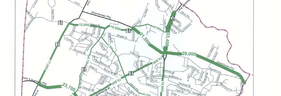
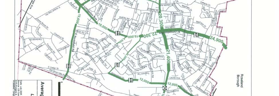
3 Professional Study of Circulation The transportation consulting firm of Orth-Rodgers Associates, Inc. was engaged to perform a study of Livingston traffic and safety conditions. That study included traffic counts made by them during 00, and review of other data from recent years. The Orth-Rodgers March 1, 00 report Livingston Township Circulation Study to the Township Council and the Planning Board has been of great help in the preparation of this Circulation Plan Element. The Tables in this Circulation Plan Element are derived from that report. Figures were selected from that report and bear the numbers in that report, Existing Conditions Traffic volumes at key intersections were measured by Orth-Rodgers. The study determined that the morning peak traffic is in the period from : a.m. to : a.m., while the evening peak period is from :00 p.m. to :00 p.m. The volumes for the morning peak period are shown in Figure 1, and those for evening peak period are shown in Figure. Average daily volumes for key road segments are shown in Figure. Many intersections of key roadways either present traffic flow delays or safety hazards that justify improvements. Delays at intersections were measured at peak traffic hours and are described as Level of Service. Safety hazards were identified through an analysis of accident reports. Correctable conditions regarding pedestrian safety, and opportunity for bicycle routes and mixed use trails, have also been identified. Section V
4 Section V
5 Section V
6 Section V
7 Level of Service Level of Service grades intersections by expected traffic delay. Unsignalized Intersections. At intersections without traffic lights ( unsignalized intersections ), levels of service are identified by lower case letters. Levels of Service for such intersections range from Level of Service a (indicating average delays of seconds or less) to Level of Service f (indicating average delays greater than 0 seconds). Level of Service d is generally considered as the acceptable limit of delay for most drivers in a suburban setting. Levels of Service e and f are considered unacceptable. The Levels of Service for unsignalized intersections are described in Table V-. Table V-: Level of Service for Unsignalized Intersections Average Total Delay per Vehicle Level of Service (seconds) a 0 to.0 b.1 to 1.0 c 1.1 to.0 d.1 to.0 e.1 to 0.0 f over 0 Signalized Intersections. Levels of Service for signalized intersections are identified by capital letters and are described in Table V-. Table V-: Level of Service for Signalized Intersections Level of Service Average Total Delay per Vehicle (seconds) A 0 to.0 B.1 to 0.0 C 0.1 to.0 D.1 to.0 E.1 to 0.0 F over 0.0 At signalized intersections, factors that affect the capacities of the approaches to the intersection include width of approach, number of lanes, signal green time, turning percentages, truck volumes, etc. Delays cannot be related to capacity in a simple one-to-one fashion. It is possible to have substantial delays at the level of service F without exceeding roadway capacity if one or more of the following conditions exist: Long signal cycle lengths; A particular traffic movement experiences a long red time; or, Section V
8 Progressive movement for a particular lane group is poor. Existing Level of Service Conditions Capacity analyses were performed for nine signalized intersections and one unsignalized intersection that were identified as most-likely in need of remediation. Their AM peak hour Levels of Service are illustrated in Figure. PM peak hour Levels of Service are illustrated in Figure. AM Peak Hour Levels of Service During the AM peak hour, three intersections have an average level of service considered to be failing. The greatest delay is experienced at the intersection of E. Mt. Pleasant Avenue and Shrewsbury Drive: graded F because of an average delay of seconds per vehicle. Three of the four approaches to that intersection have a Level of Service of F, with the southbound through/right movement having the greatest delay at seconds. The northbound approach to W. Mt. Pleasant on Hillside Avenue operates at an F, with an average delay of seconds. The South Orange Avenue and Walnut Street/Passaic Avenue intersection is failing at an overall Level of Service of E and an average delay of seconds. Both the left and the through/right movements on the westbound approach are graded F. At Walnut Street and West Hobart Gap Road, the only unsignalized intersection having a volume of traffic deemed high enough to justify having a Level of Service analysis, there is an average delay of seconds and an overall Level of Service f. Two signalized intersections have an overall level of service D : South Livingston Avenue and Northfield Road ( second delay) and Northfield Road and Hillside Avenue ( second delay). On Livingston Avenue, the signalized intersections with Mt. Pleasant Avenue, W. Cedar St./E. Cedar St., and Belmont Drive/ W. Oakwood Av. all operate at an acceptable AM Level of Service of C. PM Peak Hour Levels of Service Most of the intersections examined process their heavier traffic volumes in the evening peak hour. Therefore, Levels of Service then are typically worse than in the morning peak hour. Five intersections have failing levels of service during the PM peak hour; two of them with a Level of Service of F of f. The greatest evening peak hour delay is experienced at Mt. Pleasant Avenue and Livingston Avenue, with an average delay of seconds for all vehicles. At this intersection, the through/right movements on both the northbound and southbound approaches are rated F, while the left turn movements on both the eastbound and westbound approaches are also F. Section V
9 However, the through movements on the eastbound and westbound approaches experience only modest delays. The intersection graded f is Walnut Street and West Hobart Gap Road. In addition: At the intersection of South Livingston Avenue and Northfield Road, the northbound through/right and the southbound left are F movements. The northbound movements at Mt. Pleasant Avenue and Walnut Street operate at F with delays of to seconds. Two intersections are graded E : South Orange Avenue and Walnut Street/ Passaic Avenue, South Livingston Avenue and Northfield Road. The average delay at South Orange Avenue and Walnut Street/ Passaic Avenue is 0 seconds. That is actually an improvement over the AM peak hour with its second average delay. The improved Level of Service is due to large reductions of traffic on both the westbound and eastbound approaches as compared to morning peak hour volumes. Three intersections operate at Level of Service D : Conditions at Mt. Pleasant Avenue and Walnut Street are significantly worse in the PM peak hour than the AM peak hour, with the average delay more than doubling from to seconds for a grade of D. The intersection of South Livingston Avenue and Cedar Street operates at a Level of Service D, with an average delay of seconds per vehicle. Delays here would be even greater if not for the voluntary actions of westbound motorists. They typically queue in two lanes on the westbound approach despite the fact that the roadway is striped as only one lane. The intersection of Mt. Pleasant Avenue and Shrewsbury Drive operates at Level of Service D with an average delay of seconds. The South Livingston Avenue intersection with Belmont Drive/West Oakwood Avenue operates at a level of service C, with an average delay per vehicle of 1 seconds. Section V
10 Section V
11 Section V
12 Crash Analysis The following table indicates, in descending order, the Township intersections with the highest numbers of crashes in 00 and 00 and the numbers of each type of crash. Table V-: High Crash Level Intersections Total Crash Rank Intersection Crashes Rate Standout Crash Types 1 Livingston Circle. rear-end ( SB); sideswipe (1 EB, of these while turning left; WB, while turning left); right angle ( EB vehicles ran red light, hit SB vehicle); left turns (all illegal SB) Mt. Pleasant Avenue and 1. rear-end ( NB, SB); left turn ( WB left turn Livingston Avenue vehicles) South Livingston Avenue 1. 1 rear-end ( EB, NB); 1 left turn ( EB left turn, and Northfield Road WB left turn) West Mt. Pleasant Avenue 1. rear-end ( EB, WB); sideswipe and Okner Parkway South Orange Avenue and 1. 1 rear-end ( WB); sideswipe ( EB); left turn ( Walnut Street EB left turn); right-angle ( WB at fault) South Livingston Avenue 1. 1 left turn ( NB turning, SB turning); sideswipe and East/West Cedar ( SB, NB) Street West Mt. Pleasant Avenue rear-end ( EB); right angle; sideswipe ( EB) and Walnut Street South Livingston Avenue 1. 1 left turn ( NB left turn); sideswipe ( NB, SB) and Belmont Drive/West Oakwood Avenue South Orange Avenue and. rear-end ( EB); sideswipe ( NB) JFK Parkway West Mt. Pleasant Avenue * NA left turn ( WB left turn vehicles); rear-end ( and Hillside Avenue EB); sideswipe Eisenhower Parkway and 1* NA rear-end ( NB) Beaufort Avenue Crash Rate represents annual crashes per million vehicles entering intersection for * Number of crashes at these intersections is for year 00 only. EB = Eastbound; WB = Westbound; NB = Northbound; SB = Southbound A separate analysis of reports of accidents along the length of South Livingston Avenue from Mt. Pleasant Avenue to Northfield Road, disclosed that in the same two-year period there were accidents in addition to the crashes included in Table V-. 1 of those accidents occurred at driveways. Livingston Traffic Circle The traffic circle at the W. Mt. Pleasant Avenue (SR ), Eisenhower Parkway, W. Northfield Road junction presents unusual challenges. This is not a conventional traffic circle, because Eisenhower Parkway traffic goes through it rather than around. The design results in at least 1 legal potential traffic flows, and the risk of illegal turns. There were crashes in the two-year Section V 1
13 study period - almost twice the number at any other site and % of the total crashes in the Township. Remedial Actions Some remedial actions may improve Levels of Service at the same time that they reduce accidents. Others may serve only one of those objectives. As noted earlier, recommendations concerning signals, as well as recommendations for striping on all but local streets, will require County or State approval for implementation. W. Mt. Pleasant Avenue/Hillside Avenue intersection should be improved in two ways a. In both eastbound and eastbound directions, the curbside lanes should be for through and right-turn traffic, but the other lanes should be left-turn only. b. Change the timing on the traffic lights to establish split signal phasing for turning vehicles. W. Mt. Pleasant Avenue/Walnut Street intersection - Shift two seconds of signal time from the eastbound/eastbound signal to the northbound splitphase signal. This would reduce northbound evening peak delays for jug handle and Walnut Street traffic from the current 1 seconds to seconds, and would slightly decrease average delay for the entire intersection. (There would be minor four-second increases in eastbound and westbound delays as a trade-off.) E. Mt. Pleasant Avenue/ Shrewsbury Drive intersection should be improved in several ways a. E. Mt. Pleasant Avenue s roadway should be re-striped to provide two 1-foot lanes in each direction: a through and right-turn lane and a left-turn-only lane. b. Consideration should be given to establishing paved shoulders, curbing and sidewalks on E. Mt. Pleasant Avenue. c. Widen the southbound approach of Shrewsbury Drive so that three lanes can be provided both southbound and northbound on Shrewsbury Drive: a through and right-turn lane, a through-only lane, and a left-turn-only lane. d. Either make the Shrewsbury Drive left-turn lane lights protected signals, or post a sign, facing south, reading Opposing Traffic Has Delayed Green. Section V 1
14 So. Livingston Avenue/Northfield Road intersection - the County signal timing directive should be updated in the NJDOT format, and the eastbound and westbound left-turn clearance phase increased by 1 to seconds to reduce crash risks. Mt. Pleasant Avenue/Livingston Avenue intersection - visibility of traffic signals at this busy intersection should be improved by installing 1 signal heads in place of the signal heads. (Additional recommendations are made later in the section on pedestrian safety.) So. Livingston Avenue/Cedar Street intersection should be improved four ways a. The Cedar Street signals, timed for 1 seconds, should be actuated so that seconds of green is the norm and an additional seconds are provided only when the sensors already installed determine that traffic requires the additional time. This will reduce delays on So. Livingston Ave. b. On the westbound side of East Cedar Street, re-stripe the roadway to create a left-turn-only lane and a through and right-turn lane. c. The Official Map should be amended to eliminate the offset nature of East Cedar and West Cedar Streets and the two streets should then be re-aligned. d. When those streets have been re-aligned (1) Green lights for eastbound and westbound traffic can be simultaneous rather than sequential. () Dedicated left-turn lanes should be established on So. Livingston Avenue. So. Livingston Avenue/Belmont Drive/West Oakwood Drive Intersection should be improved in two ways: a. Northbound and southbound traffic on So. Livingston Avenue should be provided a permissive left-turn signal. b. The two lanes in each direction on So. Livingston Avenue should be re-striped to provide a through and right-turn lane and a left-turn-only lane. Section V 1
15 So. Livingston Avenue/Concord Drive intersection - traffic delays caused by cars entering or leaving the ShopRite driveway, and accident risks, can be reduced, by a. Relocating the ShopRite driveway so that it is directly opposite Concord Drive. b. Installing a traffic signal at that intersection. Livingston Traffic Circle long-term and near-term actions are recommended. a. Long-term Request that NJDOT conduct a new comprehensive study of the junction s design, the potential for reduction of hazards by redesign and the reduction of traffic flows by providing alternate roadways, such as the joining of Industrial Parkway and Executive Parkway. b. Near-term Request that NJDOT 1. Install overhead signage on SR west of the Circle to indicate appropriate lanes to be used by eastbound vehicles for permitted traffic flows.. Install similar signage east of the Circle for the same purpose.. Control right turns from southbound Eisenhower Parkway by a dedicated traffic light.. Modify the traffic light controlling vehicles entering the Circle from Northfield Road so as to separately control those turning west on SR and those that will go north on Eisenhower Parkway. Also, install overhead signs indicating proper lanes for those traffic flows.. Change the landscaping in the islands of the Circle to eliminate obstruction of driver lines of sight. Livingston Circle By-pass Since NJDOT studies have clearly established that connection of Industrial Parkway and Executive Parkway would provide relief upon Livingston Traffic Circle conditions, efforts should continue to resolve environmental issues. Livingston Avenue Driveways & Business Parking The 1 reported accidents at business driveways along Livingston Avenue warrant the following recommendations: Section V 1
16 Pedestrians a. Adjacent business properties should share common parking areas and reduce the number of driveways. b. Wherever possible, reduce or eliminate the number of business driveways on Livingston Avenue, Mt. Pleasant Avenue and Northfield Road by requiring driveways to be on intersecting side streets. c. Enable the Planning Board to reduce the number of required parking spaces on sites where a., b. and c. above have been implemented. Livingston Avenue/Mt. Pleasant Avenue By-pass - Establish a by-pass road along the westerly side of Canoe Brook between Arden Road and E. Mt. Pleasant Avenue so that vehicles transiting both E. Mt. Pleasant Avenue and S. Livingston Avenue can bypass the Livingston Avenue/Mt. Pleasant Avenue intersection. Livingston Town Center Area - Traffic conditions should be closely monitored as the Livingston Town Center becomes occupied and active. As conditions warrant, efforts should be made to obtain County and State approval of further improvements, such as: a. Installing a traffic light on E. Mt. Pleasant Avenue at the intersection with the Esplanade and with the driveway of the retail complex on the opposite side of the avenue. b. Upon installation of that light, eliminate the left-turn-in and -out prohibitions at the Esplanade, and relocate the midstreet pedestrian crosswalk and signals to that light. Improving pedestrian safety is an important part of making the downtown areas of the Township more pedestrian-friendly. Segments of Mt. Pleasant Avenue have significant and increasing pedestrian traffic but no sidewalks. This is particularly a problem in the westerly portion of the Township. All intersections on Livingston Avenue, Mt. Pleasant Avenue, Northfield Road and at the Livingston Traffic Circle, and all crosswalks at Township schools and recreation facilities, should have continental-style crosswalk striping; except that principal intersections may have crosswalks of paving material of contrasting color delineated by -1 inch-wide white reflective bands. Pedestrian countdown traffic signals should be installed Section V 1
17 Bicycles at the Intersections: Livingston Avenue/Mt. Pleasant Avenue; Livingston Avenue/Belmont Drive/Oakwood Avenue; Shrewsbury Drive/Mt. Pleasant Avenue; and at the Livingston Traffic Circle. Yield to Pedestrians signs should be posted on approaches to intersections that have striped crosswalks not protected by pedestrian traffic signals. New asphalt sidewalks should be prohibited. Existing asphalt sidewalks when replaced, and all new sidewalks, should be of concrete or made with pavers. All sidewalks in residential zoning districts should be not less than four () feet wide, and those on streets within the Business Improvement District should be not less than five () feet wide. Install sidewalks, where absent, on both sides of entire length of Mt. Pleasant Avenue. Presently, there are no provisions for bicycle paths or routes within the Township. Designation of bicycle routes can promote that mode of in-town mobility and improve cyclist safety. NJDOT guidelines for determining bicycle compatibility of roads are set forth in Table V-. Table V-: NJDOT Bicycle Compatibility Guidelines. (Based Upon Average Annual Daily Traffic ADDT ) Condition I: AADT Speed Limit Urban w/ Parking Urban w/o Parking Rural < 0 mph Shared lane (1 ft.) Shared lane ( ft.) Shared lane ( ft.) 1-0 mph Shared lane (1 ft.) Shared lane (1 ft.) Shared lane (1 ft.) 1-0 mph Shared lane (1 ft.) Shared lane (1 ft.) Shoulder ( ft.) >0 mph Not Applicable (NA) Shoulder ( ft.) Shoulder ( ft.) For volumes less than 0, a shared lane is acceptable. Condition II: AADT 000-,000 Speed Limit Urban w/ Parking Urban w/o Parking Rural < 0 mph Shared lane (1 ft.) Shared lane (1 ft.) Shared lane (1 ft.) 1-0 mph Shared lane (1 ft.) Shared lane (1 ft.) Shoulder ( ft.) 1-0 mph Shared lane (1 ft.) Shared lane (1 ft.) Shoulder ( ft.) >0 mph Not Applicable (NA) Shoulder ( ft.) Shoulder ( ft.) Section V 1
18 Condition III: AADT over,000 or Trucks over % Speed Limit Urban w/ Parking Urban w/o Parking Rural < 0 mph Shared lane (1 ft.) Shared lane (1 ft.) Shared lane (1 ft.) 1-0 mph Shared lane (1 ft.) Shoulder ( ft.) Shoulder ( ft.) 1-0 mph Shared lane (1 ft.) Shoulder ( ft.) Shoulder ( ft.) >0 mph Not Applicable (NA) Shoulder ( ft.) Shoulder ( ft.) Note: Whenever possible, a shoulder of at least feet should be provided on roadways with an AADT greater than,000 vehicles Applying those standards, Orth-Rodgers identified roadways that meet the State guidelines and are identified in this Circulation Element as Bicycle Compatible Category A, and other roadways which do not meet all guidelines but are identified as Bicycle Compatible Category B. Roadways in Category A are shown on Figure in green, and Category B roadways are shown in blue. Use of these roadways would allow bicyclists to travel between northern and eastern residential areas of the Township and the Civic Center, the Senior Community Center and the Livingston Mall. They would include Hillside Avenue, McClellan Avenue, Falcon Road, limited portions of East Cedar Street, Tiffany/Broadlawn, Walnut Street and Woodcrest Drive/Ashby Avenue. Those in Category B are roadways which have low or moderate traffic volumes and which have lower speed limits, but which allow on-street parking. For streets that permit on-street parking, NJDOT Guidelines normally require 1 or 1 foot travel lanes in addition to the width needed for two parking lanes. However, on-street parking is rarely used on residential streets in Livingston Township. In part this is because virtually every home has a garage and a driveway of adequate length to accommodate personal vehicles. Further, the Township prohibits on-street parking from to AM. Because of the infrequent occurrence of on-street parking, the roadways in Category B typically have ample width to separate passing vehicles from bicyclists, and the roadways can comfortably be used by bicyclists of all skill levels. Roadways that do not meet NJDOT standards, or the more liberal Category B standards, are Mt. Pleasant Avenue, most of Livingston Avenue from Carrillon Circle south to Northfield Road, Northfield Road, Hobart Gap Road, portions of Walnut Street and East Cedar Street from South of Whittier Way to Northfield Road. Bicycle use on those roadways should not be encouraged unless significant improvements are provided. A town-wide system of bicycle routes proposed by Orth-Rodgers is shown Figure. Additional routes may also be appropriate. Section V

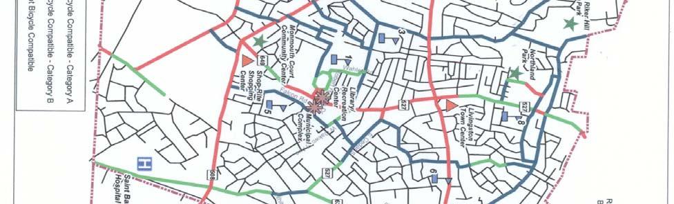
19 Figure Section V

20 Figure Section V 0
21 Roadways in Category A and Category B should have bicycle lanes painted and appropriate signs posted. Request Essex County to designate shoulders of Shrewsbury Drive for bicycles. Hobart Gap Road and S. Orange Avenue offer opportunities to integrate the southerly portion of the Township into the bicycle compatible roadway network if the City of East Orange will allow a bicycle path to be built along the fringe of the water reserve. Construct a pedestrian/bicycle bridge across Canoe Brook at Sherbrooke Parkway. Identify other opportunities for safe bicycle routes consistent with traffic flows and parking needs. Provide bicycle racks at municipal buildings, recreation facilities, and schools, and at shopping destinations and commuter bus stops. Recommendations for establishing pedestrian/bicycle paths on utility rights-of-way will be found in Section VIII, the Recreation & Open Space Plan Element. Public Transportation Five inter-city bus routes serve the Township. New Jersey Transit Route 0 runs between the Livingston Mall and Newark Penn Station. Within the Township, it travels along Eisenhower Parkway, South Orange Avenue and JFK Parkway. After leaving the Township eastbound, it passes through northern Union County and southern Essex County to Newark Penn Station, stopping at regional destinations such as the Short Hills Mall, and the Morris and Essex rail stations in Summit and Milburn. Passengers may also transfer to New Jersey Transit Route at the Livingston Mall for increased service within the region. Weekday peak hour intervals between buses range from to minutes. During the morning commute period of :00 AM to :00 AM, there are six runs to Newark, and eight to Livingston Mall. The Saturday peak hour intervals are approximately 0 minutes, and Sunday peak hour intervals are 0 minutes. New Jersey Transit Route 1 provides daily service between Essex Mall in West Caldwell and Newark Penn Station. Within Livingston Township, Route 1 travels along North Livingston Avenue and Mount Pleasant Avenue. Route 1 provides connections to the Morris and Essex rail lines in East Orange and Orange. During the morning commute period of :00 AM to :00 AM, there are seven runs to Newark, and 1 to West Caldwell. Route 1 has peak hour intervals of approximately 0 minutes on weekdays and 0-0 minutes on weekends. New Jersey Transit Route provides daily service between the Livingston Mall and Newark Penn Station via the towns of Orange, West Orange, and East Orange. Route provides the most extensive service in Livingston Township, traveling along Eisenhower Section V 1
22 Parkway, Mount Pleasant Avenue, South Livingston Avenue, and Northfield Road. Route also operates limited service to Saint Barnabas Hospital on Old Short Hills Road as well as express routes that travel along I-0 from Eisenhower Parkway (bypassing the remaining stops in Livingston Township) to Northfield Avenue in Orange Township. It provides service to the Morris and Essex rail lines in East Orange and Orange. Passengers may transfer to New Jersey Transit Route 0 at the Livingston Mall or to New Jersey Transit Route 1 at Mount Pleasant Avenue and Livingston Avenue. During the morning commute period of :00 AM to :00 AM, there are 1 runs to Livingston, and eight to Newark. Route has peak hour intervals ranging from 1 to 0 minutes on weekdays and of 0 minutes on weekends. Morris County Metro Route is sponsored by Morris County with cooperation from New Jersey Transit. MCM provides weekday and Saturday service between the Livingston Mall and the Morris County offices in Morristown. It also stops in Madison, and serves regional destinations such as the Short Hills Mall, Fairleigh Dickinson University, and Drew University. MCM is a limited service route, operating primarily during the day with one-hour headways. Community Coach Route runs daily between Morristown and the Port Authority Bus Terminal in Manhattan. Route stops in the towns of Clifton, East Hanover, East Orange, Florham Park, Livingston, West Orange, and Whippany. Within Livingston Township, Route typically varies between stopping at the intersection of Mt. Pleasant Avenue and Okner Parkway or the Park & Ride Lot at the Livingston Mall. It always stops at the Livingston Circle, and South Livingston Avenue and Mt. Pleasant Avenue. This route is almost entirely focused on serving the traditional commute into New York City. During the morning commute period of :00 AM to :00 AM, there are 1 runs to New York City, and only one to Livingston. Route has peak hour ontervals ranging from to 0 minutes. There is no local in-town bus service, although a limited door-to-door service is provided by the Township to aged and handicapped residents by appointment. Most intra-city bus route stops are for pick-up only or drop-off only. The Township has completed arrangements to provide low-cost commuter parking both at the County facility at the Richard Codey Arena in West Orange and at a Shriners property in town. The in-town effort is coupled with initiation of a limited Community Coach express service to New York City. New ordinances limit on-street parking by commuters. Continue to encourage the use of inter-city buses by providing or arranging for low-cost off-street commuter parking facilities and improved bus service. The operators of inter-city bus routes should be requested to provide local service on their buses while operating in the Township. The Township and the Business Improvement District should Section V
23 explore implementation of a shoppers jitney service within the district if intercity buses do not provide requested local service. Develop cooperative arrangements with non-residential property owners along inter-city bus routes to provide commuter parking in under-utilized parking spaces. Continue to review, establish, amend and enforce parking restrictions that will reduce or eliminate use of residential streets for parking of vehicles of persons who utilize inter-city bus services. Continue to explore the feasibility of establishing dedicated bus service to connect locations in the Township with commuter rail stations in nearby communities. Section V
24 Section IV 1
SECTION V - CIRCULATION PLAN
 - CIRCULATION PLAN 1 2 - CIRCULATION PLAN ELEMENT INTRODUCTION As a community that is essentially fully-developed, Livingston s transportation improvement opportunities are limited. The primary mode of
Classification Criteria
 SCHEDULE D TO RECOMMENDED OFFICIAL PLAN AMENDMENT NO. 40 SCHEDULE C-4 Road Criteria Criteria Traffic Service Objective Land Service/Access Typical Daily Traffic Volume Flow characteristics Travel Speed
TRAFFIC IMPACT ANALYSIS
 TRAFFIC IMPACT ANALYSIS FOR THE CHAMPAIGN UNIT#4 SCHOOL DISTRICT PROPOSED HIGH SCHOOL (SPALDING PARK SITE) IN THE CITY OF CHAMPAIGN Final Report Champaign Urbana Urbanized Area Transportation Study 6/24/2014
5. RUNNINGWAY GUIDELINES
 5. RUNNINGWAY GUIDELINES These guidelines should be considered collectively when making runningway decisions. A runningway is the linear component of the transit system that forms the right-of-way reserved
Roadway Classification Design Standards and Policies. Pueblo, Colorado November, 2004
 Roadway Classification Design Standards and Policies Pueblo, Colorado November, 2004 Table of Contents Page Chapter 1. General Provisions 1.1 Jurisdiction 3 1.2 Purpose and Intent 3 1.3 Modification 3
OTTAWA TRAIN YARDS PHASE 3 DEVELOPMENT CITY OF OTTAWA TRANSPORTATION IMPACT STUDY. Prepared for:
 OTTAWA TRAIN YARDS PHASE 3 DEVELOPMENT CITY OF OTTAWA TRANSPORTATION IMPACT STUDY Prepared for: The Ottawa Train Yards Inc. 223 Colonnade Road South, Suite 212 Nepean, Ontario K2E 7K3 January 17, 2012
OFFICE/RETAIL DEVELOPMENT 1625 BANK STREET OTTAWA, ONTARIO TRANSPORTATION BRIEF. Prepared for: Canada Inc.
 OFFICE/RETAIL DEVELOPMENT 1625 BANK STREET OTTAWA, ONTARIO TRANSPORTATION BRIEF Prepared for: 9402209 Canada Inc. December 15, 2015 115-625 Report_2.doc D. J. Halpenny & Associates Ltd. Consulting Transportation
Clackamas County Comprehensive Plan
 ROADWAYS The County s road system permits the movement of goods and people between communities and regions, using any of a variety of modes of travel. Roads provide access to virtually all property. They
6.0 PEDESTRIAN AND BICYCLE FACILITIES 6.1 INTRODUCTION 6.2 BICYCLE DEMAND AND SUITABILITY Bicycle Demand
 6.0 PEDESTRIAN AND BICYCLE FACILITIES 6.1 INTRODUCTION Bicycle and pedestrian travel along and in the vicinity of the corridor is part of the vision of Somerset and Hunterdon counties and the integrated
Guidance. ATTACHMENT F: Draft Additional Pages for Bicycle Facility Design Toolkit Separated Bike Lanes: Two-Way to One-Way Transitions
 ATTACHMENT F: Draft Additional Pages for Bicycle Facility Design Toolkit Separated Bike Lanes: Two-Way to One-Way Transitions This treatment provides a transition from two-way separated bike lanes to one-way
NJDOT Complete Streets Checklist
 Background The New Jersey Department of Transportation s Complete Streets Policy promotes a comprehensive, integrated, connected multi-modal network by providing connections to bicycling and walking trip
Active Transportation Facility Glossary
 Active Transportation Facility Glossary This document defines different active transportation facilities and suggests appropriate corridor types. Click on a facility type to jump to its definition. Bike
Capital Region Council of Governments
 March 23, 2018 Capital Region Council of Governments PROJECT CONCEPT REPORT Realignment of Swamp and Northfield Road s approaches to Route 44 (Boston Turnpike) Town of Coventry SUMMARY: The Town of Coventry
Non-Motorized Transportation 7-1
 Non-Motorized Transportation 7-1 Transportation facilities no longer mean just accommodating a vehicle powered by a combustion engine. Pedestrian and non-motorized facilities are important modes of travel
Community Transportation Plan
 Community Transportation Plan Appendix A: Traffic Calming CITY OF DECATUR COMMUNITY TRANSPORTATION PLAN Appendix A: City of Decatur City-wide Residential Traffic Calming Program Process & Procedures The
Corpus Christi Metropolitan Transportation Plan Fiscal Year Introduction:
 Introduction: The Safe, Accountable, Flexible, Efficient Transportation Equity Act: A Legacy for Users (SAFETEA-LU) has continued the efforts started through the Intermodal Surface Transportation Efficiency
Route 7 Corridor Study
 Route 7 Corridor Study Executive Summary Study Area The following report analyzes a segment of the Virginia State Route 7 corridor. The corridor study area, spanning over 5 miles in length, is a multi
Southwest Bus Rapid Transit (SW BRT) Functional Planning Study - Executive Summary January 19 LPT ATTACHMENT 2.
 Functional Planning Study - Executive Summary January 19 LPT ATTACHMENT 2.") Southwest Bus Rapid Transit (SW BRT) Functional Planning Study - Executive Summary 2011 January 19 1 of 19 Introduction This executive summary presents the results of the Southwest Bus Rapid Transit (SW
Southwest Bus Rapid Transit (SW BRT) Functional Planning Study - Executive Summary 2011 January 19 1 of 19 Introduction This executive summary presents the results of the Southwest Bus Rapid Transit (SW
INDUSTRIAL BUILDING 3009 HAWTHORNE ROAD CITY OF OTTAWA TRANSPORTATION OVERVIEW REVISED. Prepared for: Canada Inc.
 INDUSTRIAL BUILDING 3009 HAWTHORNE ROAD CITY OF OTTAWA TRANSPORTATION OVERVIEW REVISED Prepared for: 7849648 Canada Inc. Octiober 1, 2015 114-598 Overview_2.doc D. J. Halpenny & Associates Ltd. Consulting
DEPARTMENT OF ENVIRONMENTAL SERVICES. North Harrison Street (Lee Highway to Little Falls Road) Comparative Analysis. Prepared for:
 Comparative Analysis. Prepared for:") DEPARTMENT OF ENVIRONMENTAL SERVICES North Harrison Street (Lee Highway to Little Falls Road) Comparative Analysis Prepared for: Arlington County Department of Environmental Services 2100 Clarendon Boulevard,
DEPARTMENT OF ENVIRONMENTAL SERVICES North Harrison Street (Lee Highway to Little Falls Road) Comparative Analysis Prepared for: Arlington County Department of Environmental Services 2100 Clarendon Boulevard,
VILLAGE OF NILES TRAFFIC CALMING POLICY
 INTRODUCTION There is increasing interest across the country in developing new strategies to reduce the speed and amount of traffic in residential neighborhoods. Measurement of speeds, traffic volumes,
Recommended Roadway Plan Section 2 - Land Development and Roadway Access
 Recommended Roadway Plan Section 2 - Land Development and Roadway Access SECTION 2 Land Development and Roadway Access 2.1 Land Use and Access Management The Federal Highway Administration (FHWA) defines
Madison Urban Area and Dane County. Bicycle Transportation Plan Summary. September Introduction. Bicycle Plan Scope and Planning Process
 Bicycle Transportation Plan Summary Madison Urban Area and Dane County Introduction September 2000 Bicycling is an important mode of transportation in the Madison urban area and countywide that is available
Duwamish Way-finding and CTR Report
 V. North Tukwila When the North Tukwila Manufacturing and Industrial Center was designated in 1992 as part of the region s land use and transportation plan, the plan called for the area to set a light-rail
Access Location, Spacing, Turn Lanes, and Medians
 Design Manual Chapter 5 - Roadway Design 5L - Access Management 5L-3 Access Location, Spacing, Turn Lanes, and Medians This section addresses access location, spacing, turn lane and median needs, including
Blair/Williamson Intersection Expressed Needs
 Blair/Williamson Intersection Expressed Needs NORTH Blair Street is a barrier for pedestrians and bicycles Relocate Capitol City Trail crossing from Blair Street and John Nolen Drive intersection to Williamson
Date: April 4, Project #: Re: A Street/Binford Street Traffic/Intersection Assessment
 To: Peter Cavanaugh General Electric From: David Bohn, PE Ryan White, PE Date: April 4, 217 Project #: 13421. Re: / Traffic/Intersection Assessment Consistent with the Cooperation Agreement between the
4. ENVIRONMENTAL IMPACT ANALYSIS 9. TRANSPORTATION AND TRAFFIC
 4. ENVIRONMENTAL IMPACT ANALYSIS 9. TRANSPORTATION AND TRAFFIC 4.9.1 INTRODUCTION The following section addresses the Proposed Project s impact on transportation and traffic based on the Traffic Study
Appendix 3 Roadway and Bike/Ped Design Standards
 Appendix 3 Roadway and Bike/Ped Design Standards OTO Transportation Plan 2040 4/20/2017 Page A3-1 Adopted Standards The adopted OTO Design Standards and Major Thoroughfare Plan are contained herein.
TRANSPORTATION ANALYSIS REPORT US Route 6 Huron, Erie County, Ohio
 TRANSPORTATION ANALYSIS REPORT US Route 6 Huron, Erie County, Ohio December 12, 2012 Prepared for: The City of Huron 417 Main Huron, OH 44839 Providing Practical Experience Technical Excellence and Client
HENDERSON DEVELOPMENT 213, 217, 221, 221 ½, 223 HENDERSON AVENUE and 65 TEMPLETON STREET OTTAWA, ONTARIO TRANSPORTATION OVERVIEW.
 HENDERSON DEVELOPMENT 213, 217, 221, 221 ½, 223 HENDERSON AVENUE and 65 TEMPLETON STREET OTTAWA, ONTARIO TRANSPORTATION OVERVIEW Prepared for: 2294170 Ontario Inc. February 2, 2017 117-652 Report_1.doc
Glenn Avenue Corridor Traffic Operational Evaluation
 Glenn Avenue Corridor Traffic Operational Evaluation PREPARED FOR: THE CITY OF AUBURN PREPARED BY: DECEMBER 2007 Glenn Avenue Corridor Study--Auburn, Alabama TABLE OF CONTENTS Introduction... 1 Background
Summary: Mercer County Princeton Avenue & Spruce Street Study January 2009
 Summary: Several recent studies have assessed potential development and redevelopment opportunities in the Mercer Crossing area of Trenton, Ewing, and Lawrence. This Princeton Avenue and Spruce Street
METHODOLOGY. Signalized Intersection Average Control Delay (sec/veh)
") Chapter 5 Traffic Analysis 5.1 SUMMARY US /West 6 th Street assumes a unique role in the Lawrence Douglas County transportation system. This principal arterial street currently conveys commuter traffic
Chapter 5 Traffic Analysis 5.1 SUMMARY US /West 6 th Street assumes a unique role in the Lawrence Douglas County transportation system. This principal arterial street currently conveys commuter traffic
Broad Street Bicycle Boulevard Design Guidelines
 Broad Street Bicycle Boulevard Design Guidelines Building from the strategies introduced in the 2013 Bicycle Transportation Plan and community input received thus far, City Transportation Staff have identified
Chapter 3 DESIGN SPECIFICATIONS
 Brampton PathWays Planning and Design Guidelines 27 Chapter 3 DESIGN SPECIFICATIONS 3.1 CLASS 1 MULTI-USE PATH Off-road multi-use trails are the backbone of the Brampton PathWays Network. They are typically
3.0 PROJECT DESCRIPTION
 The following section of the Draft EIR contains a description of the proposed Elk Grove Boulevard/SR 99 Interchange Modification project, consistent with the requirements of CEQA Guidelines Section 15124.
10.0 CURB EXTENSIONS GUIDELINE
 10.0 CURB EXTENSIONS GUIDELINE Road Engineering Design Guidelines Version 1.0 March 2017 City of Toronto, Transportation Services City of Toronto Page 0 Background In early 2014, Transportation Services
MEDICAL/OFFICE BUILDING 1637 BANK STREET OTTAWA, ONTARIO TRANSPORTATION OVERVIEW. Prepared for:
 MEDICAL/OFFICE BUILDING 1637 BANK STREET OTTAWA, ONTARIO TRANSPORTATION OVERVIEW Prepared for: 2434984 Ontario Inc. 13-5510 Canotek Road Ottawa, Ontario K1J 9J5 June 4, 2015 115-613 Report_2.doc D. J.
Memorandum. Sunday, July 13, Saturday, July 19, 2014
 Memorandum To: David Lowin, Brooklyn Bridge Park Corporation From: Daniel Schack, AICP, PTP Date: Re: Brooklyn Bridge Park Pier 5/6 Loop Road Traffic Study Project No: 14-01-2407 At the request of Brooklyn
NEW YORK CENTRAL PARK SUBDIVISION BLAIS STREET/ST-PIERRE STREET EMBRUN, ONTARIO TRAFFIC IMPACT STUDY. Prepared for:
 NEW YORK CENTRAL PARK SUBDIVISION BLAIS STREET/ST-PIERRE STREET EMBRUN, ONTARIO TRAFFIC IMPACT STUDY Prepared for: Solidex Holdings Limited & Investissement Maurice Lemieux Investments Attn: Mr. Anthony
Reference number /VP. Lafayette Downtown Congestion Study - Additional Traffic Analysis
 To James Hinkamp and Tony Coe, City of Lafayette Date January 19, 2017 Copies Reference number 243381/VP From Michael Iswalt and Vanessa Peers File reference 4-05 Subject Lafayette Downtown Congestion
MEMORANDUM. Charlotte Fleetwood, Transportation Planner
 MEMORANDUM Date: Updated August 22, 2017 To: Organization: Charlotte Fleetwood, Transportation Planner Boston Transportation Department From: Jason DeGray, P.E., PTOE, Regional Director of Engineering
Donahue Drive Corridor Traffic Operational Evaluation
 Donahue Drive Corridor Traffic Operational Evaluation PREPARED FOR: THE CITY OF AUBURN PREPARED BY: JANUARY 2007 Donahue Drive Corridor Study--Auburn, Alabama TABLE OF CONTENTS Introduction... 1 Background
TRASBURG RANSPORTATION
 TRASBURG RANSPORTATION LAN DEVELOPED BY THE TRANSPORTATION PLANNING DIVISION OF THE VIRGINIA DEPARTMENT OF TRANSPORTATION IN COOPERATION WITH THE U.S. DEPARTMENT OF TRANSPORTATION, FEDERAL HIGHWAY ADMINISTRATION
TRAFFIC STUDY. Birch Bluff Road / Pleasant Avenue 01/15/2018. City of Tonka Bay 4901 Manitou Road Tonka Bay, MN WSB PROJECT NO.
 TRAFFIC STUDY Birch Bluff Road / Pleasant Avenue 01/15/2018 City of Tonka Bay 4901 Manitou Road Tonka Bay, MN 55331 WSB PROJECT NO. 10805-000 Birch Bluff Road/ Pleasant Avenue Traffic Study For: City of
Draft North Industrial Area-Wide Traffic Plan
 Summary of North Industrial and Hudson Bay Industrial Recommended Improvements Table 1. Summary of s Item Location 1 2 3 4 5 6 7 8 9 10 11 12 Millar Ave north of 51st St Super 8 Motel back lane 400 Block
Chapter 4 Traffic Analysis
 Chapter 4 Traffic Analysis PURPOSE The traffic analysis component of the K-68 Corridor Management Plan incorporates information on the existing transportation network, such as traffic volumes and intersection
Waterford Lakes Small Area Study
 Waterford Lakes Small Area Study Existing Traffic Conditions PREPARED FOR: ORANGE COUNTY PUBLIC WORKS DEPARTMENT TRAFFIC ENGINEERING DIVISION ORLANDO, FLORIDA PREPARED WITH: INWOOD CONSULTING ENGINEERS
M-58 HIGHWAY ACCESS MANAGEMENT STUDY Mullen Road to Bel-Ray Boulevard. Prepared for CITY OF BELTON. May 2016
 M-58 HIGHWAY ACCESS MANAGEMENT STUDY Prepared for CITY OF BELTON By May 2016 Introduction Missouri State Highway 58 (M-58 Highway) is a major commercial corridor in the City of Belton. As development has
1 st and 2 nd Street Couplet FAQ s
 1 st and 2 nd Street Couplet FAQ s Q. Will the proposed roundabout at Flume/2nd/1 st Streets affect access to businesses nearby?... 2 Q. What if the project isn t received well by the community after construction?...
CITY OF OTTAWA ROADWAY MODIFICATION APPROVAL UNDER DELEGATED AUTHORITY
 RMA-2015-ATM-038 CITY OF OTTAWA ROADWAY MODIFICATION APPROVAL UNDER DELEGATED AUTHORITY DATE: April 22, 2015 SUBJECT Approval of Roadway Modifications Recommended through an Area Traffic Management Study
THE FUTURE OF THE TxDOT ROADWAY DESIGN MANUAL
 THE FUTURE OF THE TXDOT ROADWAY DESIGN MANUAL Kenneth Mora, P.E. (Design Division) 10/10/2017 Table of contents 1 2 Reduction in FHWA design controlling criteria Innovative Intersection Guidance 3-7 8-42
ORANGE COUNTY PUBLIC WORKS TRAFFIC INVESTIGATIONS
 ORANGE COUNTY PUBLIC WORKS TRAFFIC INVESTIGATIONS STAFF REPORT OF: January 6, 2019 SUPERVISORIAL DISTRICT: 5 SUBJECT: LOCATION: INVESTIGATOR: O Neill Drive at Roanoke Drive; Ladera Ranch; TB 922-E6 Clever
Traffic Study North Shore School District 112
 Traffic Study North Shore School District 112 Proposed Expansion of Northwood Junior High School Prepared By: May 1, 2015 1. Introduction Kenig, Lindgren, O Hara, Aboona, Inc. (KLOA, Inc.) has been retained
TRAFFIC IMPACT STUDY COMPREHENSIVE UPDATE TOWN OF THOMPSON S STATION, TENNESSEE PREPARED FOR: THE TOWN OF THOMPSON S STATION
 TRAFFIC IMPACT STUDY COMPREHENSIVE UPDATE TOWN OF THOMPSON S STATION, TENNESSEE PREPARED FOR: THE TOWN OF THOMPSON S STATION Transportation Consultants, LLC 1101 17 TH AVENUE SOUTH NASHVILLE, TN 37212
Shockoe Bottom Preliminary Traffic and Parking Analysis
 Shockoe Bottom Preliminary Traffic and Parking Analysis Richmond, Virginia August 14, 2013 Prepared For City of Richmond Department of Public Works Prepared By 1001 Boulders Pkwy Suite 300, Richmond, VA
Traffic Circulation Study for Neighborhood Southwest of Mockingbird Lane and Airline Road, Highland Park, Texas
 ARIZONA TEXAS NEW MEXICO OKLAHOMA February 13, 2015 Mr. Meran Dadgostar P.E., R.S. Town of Highland Park 4700 Drexel Dr. Highland Park, Texas 75205 Re: Traffic Circulation Study for Neighborhood Southwest
CITY OF OAKLAND. 27th Street Bikeway Feasibility and Design. Final Report (v3) March 23, Kimley-Horn and Associates, Inc.
 March 23, Kimley-Horn and Associates, Inc.") CITY OF OAKLAND 27th Street Bikeway Feasibility and Design Final Report (v3) March 23, 2007 PREPARED BY: Kimley-Horn and Associates, Inc. Table of Contents 1. Introduction 3 2. 27 th Street/Bay Place Corridor
CITY OF OAKLAND 27th Street Bikeway Feasibility and Design Final Report (v3) March 23, 2007 PREPARED BY: Kimley-Horn and Associates, Inc. Table of Contents 1. Introduction 3 2. 27 th Street/Bay Place Corridor
City of Vestavia Hills Traffic Calming Policy for Residential Streets
 City of Vestavia Hills Traffic Calming Policy for Residential Streets PURPOSE: The purpose of the Traffic Calming Policy for Residential Streets is to address safety concerns related to vehicular traffic
MEETING FACILITY 2901 GIBFORD DRIVE CITY OF OTTAWA TRANSPORTATION BRIEF. Prepared for: Holiday Inn Express 2881 Gibford Drive Ottawa, ON K1V 2L9
 MEETING FACILITY 2901 GIBFORD DRIVE CITY OF OTTAWA TRANSPORTATION BRIEF Prepared for: Holiday Inn Express 2881 Gibford Drive Ottawa, ON K1V 2L9 December 18, 2012 112-566 Brief_1.doc D. J. Halpenny & Associates
EUCLID AVENUE PARKING STUDY CITY OF SYRACUSE, ONONDAGA COUNTY, NEW YORK
 EUCLID AVENUE PARKING STUDY CITY OF SYRACUSE, ONONDAGA COUNTY, NEW YORK CITY OF SYRACUSE DEPARTMENT OF PUBLIC WORKS 1200 CANAL STREET EXTENSION SYRACUSE, NEW YORK 13210 DRAFT REPORT DATE: November 13,
Traffic Impact Study. Westlake Elementary School Westlake, Ohio. TMS Engineers, Inc. June 5, 2017
 TMS Engineers, Inc. Traffic Impact Study Westlake Elementary School Westlake, Ohio June 5, 2017 Prepared for: Westlake City Schools - Board of Education 27200 Hilliard Boulevard Westlake, OH 44145 TRAFFIC
FORM A PASCO COUNTY ACCESS CONNECTION PERMIT APPLICATION
 FORM 901.3.A PASCO COUNTY ACCESS CONNECTION PERMIT APPLICATION The following information is required from all applicants directly or indirectly accessing any collector or arterial road or as otherwise
FY 2006 TRANSPORTATION CAPITAL PROGRAM
 Eden Lane Bridge over Whippany River NS9908 The existing structure was built in 1972 as a temporary single-span structure. The bridge consists of simply supported steel acrow panel trusses and is supported
CURBSIDE ACTIVITY DESIGN
 5 CURBSIDE ACTIVITY DESIGN This chapter provides design guidance for separated bike lanes adjacent to curbside activities including parking, loading and bus stops. Typical configurations are presented
INTRODUCTION THOROUGHFARE SYSTEM CLASSIFICATIONS
 INTRODUCTION The thoroughfare plan will assist public officials in the development of a specialized system for efficient and safe movement of vehicular traffic while minimizing potential conflicts with
New Seward and 36 th Avenue Intersection Conceptual Design
 University of Alaska Anchorage New Seward and 36 th Avenue Intersection Conceptual Design Prepared By: Zaid S. Hussein Dana Menendez Galen Jones Civil Engineering Department Prof. Osama Abaza CE A404 Highway
133 rd Street and 132 nd /Hemlock Street 132 nd Street and Foster Street MINI ROUNDABOUTS. Overland Park, Kansas
 133 rd Street and 132 nd /Hemlock Street 132 nd Street and Foster Street MINI ROUNDABOUTS Overland Park, Kansas September 1, 2017 TABLE OF CONTENTS 1. INTRODUCTION... 1 2. LITERATURE REVIEW... 1 3. CONCEPT
TRAFFIC CALMING POLICY & PROCEDURES
 TRAFFIC CALMING POLICY & PROCEDURES AS ADOPTED BY MONTCLAIR TOWNSHIP COUNCIL AUGUST 4, 2009 TABLE OF CONTENTS 1. INTRODUCTION... 2 Purpose... 2 Traffic Calming Definition... 2 Statement Of Township Council
Circulation in Elk Grove includes: Motor vehicles, including cars and trucks
 Circulation, as it is used in this General Plan, refers to the many ways people and goods move from place to place in Elk Grove and the region. Circulation in Elk Grove includes: Motor vehicles, including
AGENDA ITEM 6 D THOMASVILLE ROAD (HERMITAGE BOULEVARD TO LIVE OAK PLANTATION ROAD) ROADWAY SAFETY AUDIT
 ROADWAY SAFETY AUDIT") May 15, 2018 AGENDA ITEM 6 D THOMASVILLE ROAD (HERMITAGE BOULEVARD TO LIVE OAK PLANTATION ROAD) ROADWAY SAFETY AUDIT TYPE OF ITEM: Discussion STATEMENT OF ISSUE The Florida Department of Transportation
May 15, 2018 AGENDA ITEM 6 D THOMASVILLE ROAD (HERMITAGE BOULEVARD TO LIVE OAK PLANTATION ROAD) ROADWAY SAFETY AUDIT TYPE OF ITEM: Discussion STATEMENT OF ISSUE The Florida Department of Transportation
Highway 49, Highway 351 and Highway 91 Improvements Feasibility Study Craighead County
 Highway 49, Highway 351 and Highway 91 Improvements Feasibility Study Craighead County Executive Summary March 2015 Highway 49, Highway 351 and Highway 91 Improvements Feasibility Study Craighead County
Existing Conditions. Date: April 16 th, Dan Holderness; Coralville City Engineer Scott Larson; Coralville Assistant City Engineer
 Date: April 16 th, 2015 To: From: Re: Dan Holderness; Coralville City Engineer Scott Larson; Coralville Assistant City Engineer Darian Nagle-Gamm, Traffic Engineering Planner Highway 6 (2 nd Street) /
CAPE COD COMMISSION 3225 MAIN STREET P.O. BOX 226 BARNSTABLE, MA (508) Fax (508) Transportation Safety Report
 Fax (508) Transportation Safety Report") CAPE COD COMMISSION 3225 MAIN STREET P.O. BOX 226 BARNSTABLE, MA 02630 (508) 362-3828 Fax (508) 362-3136 2006 Transportation Safety Report Bourne: Otis Rotary Harwich: Route 137/Route 39 Orleans: Route
CAPE COD COMMISSION 3225 MAIN STREET P.O. BOX 226 BARNSTABLE, MA 02630 (508) 362-3828 Fax (508) 362-3136 2006 Transportation Safety Report Bourne: Otis Rotary Harwich: Route 137/Route 39 Orleans: Route
Downey Road. Transportation Improvement Study
 Downey Road Transportation Improvement Study Workshop 2 Participant Handbook Workshop 1 May 18 and 19, 2016 Workshop 2 June 23 and 28, 2016 Prepared By: City of Guelph Paradigm Transportation Solutions
Proposed Bridge Street East Bicycle Lanes Public Open House Thursday, April 27, 2017
 WELCOME Proposed Bridge Street East Bicycle Lanes Public Open House Thursday, April 27, 2017 Purpose of the Open House The purpose of this Open House is to gain public input on the bicycle lanes proposed
A plan for improved motor vehicle access on Railroad Avenue in Provincetown
 A plan for improved motor vehicle access on Railroad Avenue in Provincetown February 2011 A plan for improved motor vehicle access on Railroad Avenue in Provincetown INTRODUCTION AND PROBLEM IDENTIFICATION
Public Works Committee Meeting Richard E. Mastrangelo Council Chamber November 20, 2017
 Public Works Committee Meeting Richard E. Mastrangelo Council Chamber November 20, 2017 Purpose of Meeting Why are we here? Project Recap/Updates Project Limits/Segments Road Diet Concept Lessons Learned
West Dimond Blvd Upgrade Jodhpur Street to Sand Lake Road
 West Dimond Blvd Jodhpur St to Sand Lake CSS Transportation Project Summary Municipality of Anchorage Project # 05 005 Project Manager: John Smith, P.E. (MOA PM&E) Project Administrator: Julie Makela,
CHAPTER 16 PEDESTRIAN FACILITIES DESIGN AND TECHNICAL CRITERIA TABLE OF CONTENTS
 CHAPTER 16 PEDESTRIAN FACILITIES DESIGN AND TECHNICAL CRITERIA TABLE OF CONTENTS Section Title Page 16.1 General... 16-1 16.1.1 AASHTO Reference... 16-1 16.1.2 ADA Requirements... 16-1 16.2 Sidewalks...
County of Greenville South Carolina. Traffic Calming Program Neighborhood Traffic Education Program and Speed Hump Program
 County of Greenville South Carolina Traffic Calming Program Neighborhood Traffic Education Program and Speed Hump Program (rev) August 2008 I. PURPOSE The potential negative impacts from vehicular traffic
TRANSPORTATION IMPACT STUDY PROPOSED RIVERFRONT 47 MIXED USE DEVELOPMENT
 November 2016 TRANSPORTATION IMPACT STUDY PROPOSED RIVERFRONT 47 MIXED USE DEVELOPMENT & Aspinwall Borough, Sharpsburg Borough & O Hara Township, Allegheny County, Pennsylvania Prepared for: Riverfront
TRAFFIC ACTION PLAN. Laurie Meadows Neighborhood CITY OF SAN MATEO
 TRAFFIC ACTION PLAN Laurie Meadows Neighborhood CITY OF SAN MATEO Draft January 2017 Table of Contents Introduction... 2 The Traffic Forum Process... 5 Neighborhood Traffic Issues... 7 Neighborhood Recommendations
FINAL DESIGN TRAFFIC TECHNICAL MEMORANDUM
 FINAL DESIGN TRAFFIC TECHNICAL MEMORANDUM July 2014 FINAL (SR 43) Project Development and Environment Study From State Road 60 (Adamo Drive) to I-4 (SR 400) Hillsborough County, Florida Work Program Item
Los Altos Hills Town Council - June 18, 2015 Palo Alto City Council June 22, AGENDA ITEM #2.B Presentation
 Los Altos Hills Town Council - June 18, 2015 Palo Alto City Council June 22, 2015 AGENDA ITEM #2.B Presentation Previous Presentations Los Altos Hills Town Council in May 2014 and February 2015 Palo Alto
FAIRFIELD INN & SUITES HOTEL 135 THAD JOHNSON PRIVATE OTTAWA TRANSPORTATION BRIEF. Prepared for:
 FAIRFIELD INN & SUITES HOTEL 135 THAD JOHNSON PRIVATE OTTAWA TRANSPORTATION BRIEF Prepared for: Bona Building & Management Co. Ltd. Place Vanier, 333 North River Road Vanier, Ontario K1L 8B9 August 12,
5. MODIFICATIONS AT JEANNE D ARC BOULEVARD/REGIONAL ROAD 174 INTERCHANGE INTERSECTION - PUBLIC HEARING COMMITTEE RECOMMENDATION
 5. MODIFICATIONS AT JEANNE D ARC BOULEVARD/REGIONAL ROAD 174 INTERCHANGE INTERSECTION - PUBLIC HEARING COMMITTEE RECOMMENDATION Having held a public hearing, that Council approve the preliminary designs
Bluffdale/ UDOT South High-T Intersection Project Type Operations
 Bluffdale/ UDOT 14600 South High-T Intersection Project Type Operations 14600 South and Redwood Road $ 600,000 $ 550,000 This project is to install a new High-T intersection at Redwood Road and 14600 South
Access Management in the Vicinity of Intersections
 Access Management in the Vicinity of Intersections FHWA-SA-10-002 Technical Summary Photo: Ralph Bentley (used with permission) 0 Access Management is: The design, implementation and management of entry
APPENDIX E: Transportation Technical Report
 New Jersey Pennsylvania Lackawanna Cut-Off Passenger Rail Service Reston Project Environmental Assessment APPENDIX E: Transportation Technical Report E.1 Introduction As part of the overall environmental
MEMORANDUM. DATE March 1, 2012 TO Town of Milton Mark Abbott, Seth Asante, and Efi Pagitsas Boston Region MPO Staff
 MEMORANDUM DATE March 1, 212 TO Town of Milton FROM RE Mark Abbott, Seth Asante, and Efi Pagitsas Boston Region MPO Staff FFY 211 Safety and Operations Analyses at Selected Boston Region MPO Intersections:
MUTCD Part 6G: Type of Temporary Traffic Control Zone Activities
 MUTCD Part 6G: Type of Temporary Traffic Control Zone Activities 6G.01 Typical Applications Each temporary traffic control (TTC) zone is different. Many variables, such as location of work, highway type,
Chapter 2: Standards for Access, Non-Motorized, and Transit
 Standards for Access, Non-Motorized, and Transit Chapter 2: Standards for Access, Non-Motorized, and Transit The Washtenaw County Access Management Plan was developed based on the analysis of existing
TRAFFIC CALMING PLANNER S PORTFOLIO
 TRAFFIC CALMING PLANNER S PORTFOLIO ISSUE 8 January 2017 PLANNER S PORTFOLIO TRAFFIC CALMING 1 OVERVIEW 2 3 4 ENGINEERED TRAFFIC CALMING MEASURES SIGNS AND PAVEMENT MARKINGS EMERGENCY RESPONSE DELAYS 5
HILTON GARDEN INN HOTEL HOTEL EXPANSION 2400 ALERT ROAD, OTTAWA TRANSPORTATION BRIEF. Prepared for:
 HILTON GARDEN INN HOTEL HOTEL EXPANSION 2400 ALERT ROAD, OTTAWA TRANSPORTATION BRIEF Prepared for: Bona Building & Management Co. Ltd. Place Vanier, 333 North River Road Vanier, Ontario K1L 8B9 October
Proposed. City of Grand Junction Complete Streets Policy. Exhibit 10
 Proposed City of Grand Junction Complete Streets Policy Exhibit 10 1 City of Grand Junction Complete Streets Policy Vision: The Complete Streets Vision is to develop a safe, efficient, and reliable travel
o n - m o t o r i z e d transportation is an overlooked element that can greatly enhance the overall quality of life for the community s residents.
 N o n - m o t o r i z e d transportation is an overlooked element that can greatly enhance the overall quality of life for the community s residents. 84 Transportation CHAPTER 11 INTRODUCTION Transportation
APPENDIX D: SACRAMENTO URBAN AREA TRANSPORTATION PRIORITIES
 1 County County County County 2 Yolo Arterial Roadway Collector Roadway Urban Residential Street Rural Residential Roadway I-80 / U.S. 50 Bus/Carpool Lanes in both directions Richards Blvd PM Yol 80 0.237
Bay to Bay Boulevard Complete Streets Project
 Bay to Bay Boulevard Complete Streets Project Dale Mabry Highway to Bayshore Boulevard February 08, 2018 Photo Source: Tampa Bay Times Alessandra Da Pra Meeting Format Introduction Resurfacing Information