County Road 2 Long Sault Improvements EA Study Schedule C Municipal Class Environmental Assessment. Environmental Study Report
|
|
|
- Beverly Hudson
- 6 years ago
- Views:
Transcription


1 Study Schedule C Municipal Class Environmental Assessment
 228-4813 (855) 228-4813 Toll")
2 Prepared By: BT Engineering 100 Craig Henry Drive, Suite 201 Ottawa, ON K2G 5W3 (613) (855) Toll free
3 Executive Summary

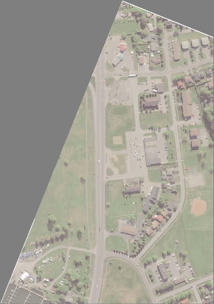
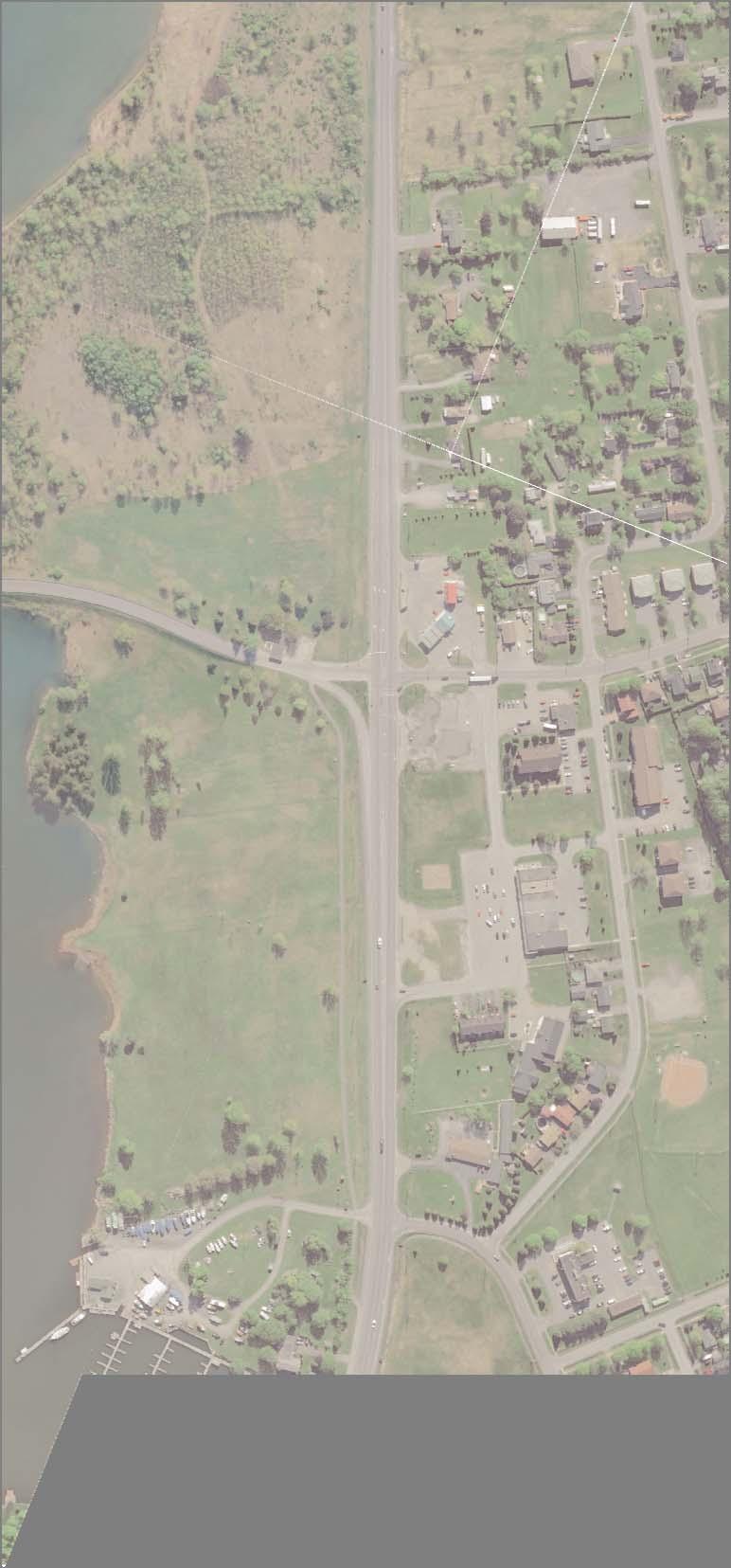
4 Executive Summary E-1 EA Project An Environmental Assessment (EA) to examine potential roadway improvements to County Road 2 from 300 m east of Robin Road to 250 m west of the intersection of County Road 35 was initiated by the United Counties of Stormont, Dundas and Glengarry in February The improvements will support asset preservation, which is part of the Counties asset management plan. The study documents the transportation need, available alternatives, and public consultation and the Recommended Plan addresses current and future operational needs considering all modes of travel. These improvements will provide all users, (pedestrians, bicycles, autos and heavy vehicles), with a safe and convenient way to travel reflecting the character of the Township s community design plan. The improvements change the roadway design from a high speed arterial through the village as originally designed when the road was under the Provincial jurisdiction to a lower speed roadway reflecting the commercial and residential adjacent land uses. The EA has examined alternatives for the cross section of County Road 2 within the Study Area. Intersection alternatives were assessed for the intersections on County Road 2 at Moulinette Road and at Mille Roches Road. E1.1 Study Area The Study Area follows County Road 2 from 400 m east of Robin Road to 250 m west of the intersection of County Road 35 (Moulinette Road). It also includes the intersection and approach of the Long Sault Parkway, under the jurisdiction of the St. Lawrence Parks Commission. This parkway is maintained by the County on behalf of the St. Lawrence Parkway Commission. The study area is located in the United Counties of Stormont, Dundas and Glengarry and is illustrated in Figure E1. Figure E1: Study Area i
5 E-2 Municipal Class EA Process This project was initiated as a Schedule B project and has followed the requirements under the Planning and Design process of the Municipal Class Environmental Assessment, as amended in 2011 by including the Phase 3 review of alternatives and public consultation that are requirements of a Schedule C project. This is a self-assessment process that includes mandatory public consultation which the study has met and exceeded by voluntarily following the requirements for a Schedule C project. The Class EA Process is undertaken in a series of phases commencing with identifying the problem and culminating in the filing of a Project File. The phases are shown in Figure E2. The Class EA process includes an evaluation of all reasonable alternatives and the selection of a preferred alternative(s) with acceptable effects (including mitigation measures) on the natural and social/cultural environments. The EA process entails five phases: Phase 1: Identify the Problem Phase 2: Alternative Solutions Phase 3: Alternative Design Concepts for the Preferred Solution Phase 4: Phase 5: Implementation This study will only be completed to the end of the municipal EA process (i.e. Phase 4), and will then proceed to Phase 5 (Implementation) when the County funds construction of the project. ii

6 ESR Final Notice November 27, 2015 PIC No. 1 January 28, 2015 PIC No. 2 September 9, 2015 Figure E2: Municipal Class EA Planning and Design Process iii

7 E-3 Consultation The public consultation approach used several techniques to proactively involve the public.the study was carried out in consultation with County staff, external agencies, the general public, property owners and technical specialists. The overall direction was provided by a Steering Committee comprised of staff and councillors from the United Counties, staff and councillors from the Township of South Stormont and staff of the St. Lawrence Parks Commission. The EA process included two Public Information Centres (PIC s). The first PIC presented the project goals, problem and opportunity statement, environmental inventories, traffic analysis including the assessment of alternatives, and Technically Recommended Alternative and obtained public/agency input/feedback. The second PIC presented the Recommended Plan including refinements based on the assessment of design concept alternatives. This EA is presented to the public and review agencies for a 30-day comment period, with the study completion notice being advertised on November 27, The County Road 2 Long Sault Improvements EA Study included several proactive consultation and public engagement techniques as follows: Two (2) Public Information Centres (PIC s) Two (2) rounds of meetings with the Study Design Team Six (6) meetings with the Study Design Team One (1) meeting each with three property owners Liaison with external agencies Consultation with First Nations group Positive feedback was received on the Recommended Plan through this consultation. An outline of the entire process can be found in Figure E3, including the consultation stages, technical decision making stages and key issues addressed. Figure E3: Key Decision Making Flow Chart iv
8 E-4 Analysis and Evaluation E4.1 Assessment of Alternative Planning Solutions The evaluation of alternatives considered alternative planning solutions. For this study, the alternative planning solutions included: Do Nothing Maintain the existing conditions (rehabilitate and repair assets) Introduce cross section contraction (remove additional lanes and add a single roundabout at County Road 35) Introduce cross sectional contraction (remove additional lanes and add two roundabouts at County Roads 35 and 36). The Do Nothing alternative was not carried forward for evaluation because it does not address the preservation of the road assets which have significant deterioration. Also it does not satisfy roadway development goals for County Road 2 that are outlined in the Township s Community Improvement Plan (CIP) and does not address safety concerns for existing entrances along the corridor. Action is required for the safety of all roadway users along County Road 2 and there is a need to define a plan which will restore the pavement, curbs and traffic control assets of the County. Therefore, the Do Nothing alternative was not carried forward. E4.3 Evaluation of Preliminary Design Alternatives The preliminary design alternatives were compared (see Section 6.0 and Appendix B) and a stepped approach has been carried forward. This approach recommends reconstruction using a roundabout at County Road 35 with long range property protection for a second roundabout at County Road 36. This will provide a safer roadway design that has greater consistency with the community design plan of the Township of South Stormont. E4.4 Technically Preferred Alternative (TPA) The Technically Preferred Alternative (TPA) for this project includes the following key features: Removing existing additional travel lanes on County Road 2 from west of Robin Road to west of Moulinette Road Constructing a new roundabout at Moulinette Road (County Road 35) Closing former commercial entrances along County Road 2 near the roundabout (where the land uses no longer exist as businesses) Constructing a raised median along County Road 2 from the roundabout at Moulinette Road to Mille Roches Road as a safety improvement The remainder of the Planning Solutions were carried forward to be assessed as preliminary design alternatives. E4.2 Preliminary Design Alternatives The four (4) preliminary design alternatives considered for this project are as follows: Alternative 1: Roadway Rehabilitation involves rehabilitating the existing roadway by milling and resurfacing the pavement throughout, replacing curbs/gutters and upgrading traffic signals. Alternative 2: Roadway Contraction involves reducing the number of through lanes (eliminating EB & WB lanes) along CR 2 and adding left and right turn lanes at CR 36. Alternative 3: Single Roundabout - involves reducing the number of through lanes (eliminating EB & WB outside lanes) along CR 2 and adding left and right turning lanes at CR 36. In addition a single lane roundabout is being proposed at CR 35. Alternative 4: Twin Roundabouts - involves reducing the number of through lanes (eliminating EB & WB outside lanes) and replacing existing intersections at CR 2/CR 35 and CR 2/ CR 36 with single lane roundabouts. v
9 E-5 Recommended Plan The TPA was presented to the public at the first and second PIC s as well as at two property owners meetings. A list of refinements was made based on input from these meetings and created the Recommended Plan, as presented in Figure E4 below. The refinements made to the TPA include: Refinement 1: Provide a left turn lane median break to accommodate eastbound turning movements into the Long Sault Plaza; Refinement 2: Extend the 2-lane cross section easterly beyond Robin Road to accommodate eastbound passing opportunities on County Road 2; Refinement 3: Provide access to the Lion Motel: and Refinement 4: (Post PIC 2) Provide a northbound left turn lane to the Tim Horton s/macewen gas station development. The Recommended Plan uses a 2-stage planning approach. The first (1 st ) stage is described as the Technically Preferred Alternative and features a single-lane roundabout at the intersection of County Road 2 and County Road 35, as well as a reduction of the cross-section to a 2-lane cross-section within the study area. The second (2 nd ) stage is known as the Long Term Plan, as illustrated in Figure E5. The Long Range Plan involves reducing the number of through lanes in both east and westbound directions and replacing intersections at County Road 2/County Road 35 and County Road 2/Count Road 36 with single-lane roundabouts. This would improve safety for road users within the village by inducing slower operating speeds, which would reduce high severity collisions. Long term operation and maintenance costs would be lower due to the reduction in pavement area that needs to be maintained. The cost of installing and maintaining traffic signals would be eliminated at County Road 2/County Road 35 and a gateway to the Long Sault Parkway would be created. The two-staged plan will continue to protect for a second intersection improvement (roundabout) at County Road 36 after the first intersection improvement is complete. Statement of Flexibility The ESR is being prepared to secure environmental approvals for improvements to both intersections and the decision on constructing one or two roundabouts as part of the project will be subject to funding availability, municipal support of funding and competing priorities in the County. vi


10


11
12 E-6 Next Steps At the end of the 30-day review period, should there be no objections to the project, then the County may proceed with design and construction of the Recommended Plan, subject to availability of funding and competing construction priorities. ix
HIGHBURY AVENUE/HAMILTON ROAD INTERSECTION IMPROVEMENTS PUBLIC INFORMATION CENTRE 1 MAY 14, 2015
 HIGHBURY AVENUE/HAMILTON ROAD INTERSECTION IMPROVEMENTS Municipal Class Environmental Assessment PUBLIC INFORMATION CENTRE 1 MAY 14, 2015 ACCESSIBILITY Under the Accessibility Standards 2015 for Customer
COUNTY ROAD 22 HORSESHOE VALLEY ROAD. Municipal Class Environmental Assessment. simcoe.ca
 OCTOBER 2014 Municipal Class Environmental Assessment COUNTY ROAD 22 HORSESHOE VALLEY ROAD Project A Truck Climbing Lanes Project B Intersection Improvements simcoe.ca CORPORATE COMMUNICATIONS DEPARTMENT
Southcote Road Improvements Class Environmental Assessment Study
 1 Southcote Road Improvements Class Environmental Assessment Study Public Information Centre #1 May 24, 2018 Study Area 2 3 Welcome The Ancaster Transportation Master Plan (2011) outlined a long range
Improving Cyclist Safety at the Dundas Street West and Sterling Road Intersection
 STAFF REPORT ACTION REQUIRED Improving Cyclist Safety at the Dundas Street West and Sterling Road Intersection Date: August 17, 2012 To: From: Wards: Reference Number: Public Works and Infrastructure Committee
Welcome to the Public Meeting. Red Hill Business Park South Transportation Master Plan Addendum. December 4, :00 p.m. to 8:00 p.m.
 Welcome Welcome to the Transportation Master Plan Addendum December 4, 2012 6:00 p.m. to 8:00 p.m. Please sign-in Background PIC#1 Public Information Centre #1 (PIC#1) was held on June 25, 2012. Feedback
122 Avenue: 107 Street to Fort Road
 : 107 Street to Fort Road November 24, 2015 4:30 8:00 p.m. Meeting Purpose Summarize project work completed to date Share results of public input from Phase 1 Share the draft concept plan and proposed
Tonight is for you. Learn everything you can. Share all your ideas.
 Strathcona Neighbourhood Renewal Draft Concept Design Tonight is for you. Learn everything you can. Share all your ideas. What is Neighbourhood Renewal? Creating a design with you for your neighbourhood.
List of Display Boards
 List of Display Boards Welcome Introduction Municipal Class Environmental Assessment (EA) Process Need and Justification for an Interchange Alternatives for Evaluation Vertical and Horizontal Alignments
Municipal Class EA To Address Traffic Congestion On The Ontario Street Corridor (Grand Bend) Public Information Meeting June 4, 2018
 Public Information Meeting June 4, 2018") Municipal Class EA To Address Traffic Congestion On The Ontario Street Corridor (Grand Bend) Public Information Meeting June 4, 2018 Background Agenda Traffic Study Update Class EA Alternatives Bridge
Municipal Class EA To Address Traffic Congestion On The Ontario Street Corridor (Grand Bend) Public Information Meeting June 4, 2018 Background Agenda Traffic Study Update Class EA Alternatives Bridge
Traffic Calming Policy
 Article I. Purpose and Goal. The purpose of this policy is to establish criteria and procedures the City will use to evaluate requests for, and if appropriate, implement traffic calming measures. Neighborhood
Glenn Avenue Corridor Traffic Operational Evaluation
 Glenn Avenue Corridor Traffic Operational Evaluation PREPARED FOR: THE CITY OF AUBURN PREPARED BY: DECEMBER 2007 Glenn Avenue Corridor Study--Auburn, Alabama TABLE OF CONTENTS Introduction... 1 Background
1. What is the Doran Street and Broadway/Brazil Grade Separation Project (Project)?
?") 1. What is the Doran Street and Broadway/Brazil Grade Separation Project (Project)? The Los Angeles County Metropolitan Transportation Authority (Metro) is evaluating the development of a grade separation
1. What is the Doran Street and Broadway/Brazil Grade Separation Project (Project)? The Los Angeles County Metropolitan Transportation Authority (Metro) is evaluating the development of a grade separation
Public Works and Infrastructure Committee. General Manager, Transportation Services
 STAFF REPORT ACTION REQUIRED Extending the Bay Street Bicycle Lanes Date: May 16, 2013 To: From: Public Works and Infrastructure Committee General Manager, Transportation Services Wards: Toronto Centre
Columbia Pike Implementation Team (CPIT) Meeting
 Meeting") Columbia Pike Implementation Team (CPIT) Meeting November 30, 2010 Agenda Introductions / Purpose of Meeting Review of project goals Multimodal project: 10% street design between the curbs Discussion Multimodal
Columbia Pike Implementation Team (CPIT) Meeting November 30, 2010 Agenda Introductions / Purpose of Meeting Review of project goals Multimodal project: 10% street design between the curbs Discussion Multimodal
Toronto and East York Community Council. Director, Transportation Services, Toronto and East York District
 No Turn on Red Regulations STAFF REPORT ACTION REQUIRED Date: June 1, 2010 To: From: Toronto and East York Community Council Director, Transportation Services, Toronto and East York District Wards: Trinity
APPENDIX 2 LAKESHORE ROAD TRANSPORTATION REVIEW STUDY EXECUTIVE SUMMARY
 APPENDIX 2 LAKESHORE ROAD TRANSPORTATION REVIEW STUDY EXECUTIVE SUMMARY Appendix 2 City of Mississauga Lakeshore Road FINAL REPORT Transportation Review Study December 2010 EXECUTIVE SUMMARY Study Purpose
2014/2015 BIKE ROUTE PLAN 83 AVENUE PROTECTED BIKE LANE
 About the Project 2014/2015 BIKE ROUTE PLAN The City of Edmonton is planning a major bike route on the south side of Edmonton. This bike route is one part of a plan to provide citizens with transportation
WELCOME TO OPEN HOUSE # 1 June 14, 2017
 Langstaff Road Weston Road to Highway 7 Class Environmental Assessment Study WELCOME TO OPEN HOUSE # 1 June 14, 2017 Please sign in and join our mailing list Purpose of Open House #1 & Study Area York
Public Information Centre
 WELCOME Public Information Centre Father Tobin Road Lougheed Middle School - Library Wednesday November 7, 2012 7:00 p.m.to 9:00 p.m. Please sign in Neighbourhood Traffic Calming Guide Background The City
Harbord Street and Hoskin Avenue Bicycle Lane Upgrades
 STAFF REPORT ACTION REQUIRED and Bicycle Lane Upgrades Date: April 22, 2014 To: From: Wards: Reference Number: Public Works and Infrastructure Committee General Manager, Transportation Services 19 and
CITY OF SASKATOON COUNCIL POLICY
 ORIGIN/AUTHORITY Clause 1, Report No. 1-1980 and Clause 4, Report No. 22-1990 of the Works and Utilities Committee; Clause 6, Report No. 17-2004 of the Planning and Operations Committee; and Clause D5,
Water Street Promenade Engineering and Design Services
 Preliminary Design Presentation Parking & Traffic Safety Committee Water Street Promenade Engineering and Design Services July 16,2014 November 3, 2016 Education / Infrastructure / Innovation 1 Project
Thank you for attending
 Improving mobility safety comfort WELCOME Thank you for attending The purpose of this meeting is to: Learn about the project Prioritize potential walking and biking improvements on Snelling Ave Gather
Los Altos Hills Town Council - June 18, 2015 Palo Alto City Council June 22, AGENDA ITEM #2.B Presentation
 Los Altos Hills Town Council - June 18, 2015 Palo Alto City Council June 22, 2015 AGENDA ITEM #2.B Presentation Previous Presentations Los Altos Hills Town Council in May 2014 and February 2015 Palo Alto
SAN FRANCISCO MUNICIPAL TRANSPORTATION AGENCY
 THIS PRINT COVERS CALENDAR ITEM NO. : 10.3 DIVISION: Sustainable Streets Division BRIEF DESCRIPTION: SAN FRANCISCO MUNICIPAL TRANSPORTATION AGENCY Approving traffic and parking modifications to install
WELCOME Public Information Centre
 WELCOME Public Information Centre Fernforest Drive Brampton Soccer Centre Community Room #2 Tuesday January 19, 2016 6:30 p.m.to 9:00 p.m. Please sign in Neighbourhood Traffic Calming Guide Background
Living Streets Policy
 Living Streets Policy Introduction Living streets balance the needs of motorists, bicyclists, pedestrians and transit riders in ways that promote safety and convenience, enhance community identity, create
DEPARTMENT OF ENVIRONMENTAL SERVICES. North Harrison Street (Lee Highway to Little Falls Road) Comparative Analysis. Prepared for:
 Comparative Analysis. Prepared for:") DEPARTMENT OF ENVIRONMENTAL SERVICES North Harrison Street (Lee Highway to Little Falls Road) Comparative Analysis Prepared for: Arlington County Department of Environmental Services 2100 Clarendon Boulevard,
DEPARTMENT OF ENVIRONMENTAL SERVICES North Harrison Street (Lee Highway to Little Falls Road) Comparative Analysis Prepared for: Arlington County Department of Environmental Services 2100 Clarendon Boulevard,
Brian McHugh, Buckhead Community Improvement District. SUBJECT: Wieuca Road at Phipps Boulevard Intersection Improvements Project
 MEMO TO: FROM: Brian McHugh, Buckhead Community Improvement District Jagan Kaja, AICP, WSP Parsons Brinckerhoff SUBJECT: Wieuca Road at Phipps Boulevard Intersection Improvements Project DATE: October
8 PROPOSED ROUNDABOUT DUFFERIN STREET AND KING VAUGHAN ROAD INTERSECTION CITY OF VAUGHAN
 8 PROPOSED ROUNDABOUT DUFFERIN STREET AND KING VAUGHAN ROAD INTERSECTION CITY OF VAUGHAN The Transportation Services Committee recommends the adoption of the recommendation contained in the following report
to the Public Information Centre for the Downtown Traffic Study
 to the Public Information Centre for the Downtown Traffic Study City of Sault Ste. Marie July 25, 2018 Purpose of Study Determine if changes to one-way corridors can enhance downtown s character and spaces
Bicycle Master Plan Goals, Strategies, and Policies
 Bicycle Master Plan Goals, Strategies, and Policies Mobilizing 5 This chapter outlines the overarching goals, action statements, and action items Long Beach will take in order to achieve its vision of
2014/2015 BIKE ROUTE PLAN 83 AVENUE PROTECTED BIKE LANE
 About the Project The City of Edmonton is planning a major bike route on the southside of Edmonton. The Strathcona Bike Route will connect the communities of Strathcona, Garneau and the University area,
6.4 RECOMMENDED IMPROVEMENTS
 6.4 RECOMMENDED IMPROVEMENTS 6.4.1 Williston Road Recommendations While all alternatives would be an improvement over existing conditions, Alternative 3B is recommended over the others because it provides
RESOLUTION NO ?? A RESOLUTION OF THE CITY OF NEPTUNE BEACH ADOPTING A COMPLETE STREETS POLICY
 RESOLUTION NO. 2018-?? A RESOLUTION OF THE CITY OF NEPTUNE BEACH ADOPTING A COMPLETE STREETS POLICY WHEREAS, safe, convenient, and accessible transportation for all users is a priority of the City of Neptune
Zlatko Krstulich, P.Eng. City of O9awa
 Zlatko Krstulich, P.Eng. City of O9awa 1. Introduction to the Ontario Traffic Manual Series 2. What is OTM Book 18: Bicycle Facilities? 3. Study / Committee Team Members 4. Brief overview of the content
Reference number /VP. Lafayette Downtown Congestion Study - Additional Traffic Analysis
 To James Hinkamp and Tony Coe, City of Lafayette Date January 19, 2017 Copies Reference number 243381/VP From Michael Iswalt and Vanessa Peers File reference 4-05 Subject Lafayette Downtown Congestion
BLUE SEA VILLAGE MER BLEUE 2159 MER BLEUE ROAD OTTAWA, ONTARIO TRANSPORTATION IMPACT ASSESSMENT. Prepared for: Ontario Limited.
 BLUE SEA VILLAGE MER BLEUE 2159 MER BLEUE ROAD OTTAWA, ONTARIO TRANSPORTATION IMPACT ASSESSMENT Prepared for: 2534189 Ontario Limited April 6, 2018 117-668 TIA Report_2.doc D. J. Halpenny & Associates
Welcome to the Open House
 Leslie Street Between 19 th Avenue and Stouffville Road Addendum to Class Environmental Assessment Study Welcome to the Open House Please sign in at the front desk. March 28, 2017 Richmond Green Sports
DUNBOW ROAD FUNCTIONAL PLANNING
 DUNBOW ROAD FUNCTIONAL PLANNING Final Report August 3, 216 #31, 316 5th Avenue NE Calgary, AB T2A 6K4 Phone: 43.273.91 Fax: 43.273.344 wattconsultinggroup.com Dunbow Road Functional Planning Final Report
Board of Supervisors February 27, 2017
 : Traffic Analysis Results & Draft Conceptual Plan Board of Supervisors February 27, 2017 Transportation Solutions Building Better Communities Presentation Overview Background Summary of Traffic Analysis
Shockoe Bottom Preliminary Traffic and Parking Analysis
 Shockoe Bottom Preliminary Traffic and Parking Analysis Richmond, Virginia August 14, 2013 Prepared For City of Richmond Department of Public Works Prepared By 1001 Boulders Pkwy Suite 300, Richmond, VA
City of Elizabeth City Neighborhood Traffic Calming Policy and Guidelines
 City of Elizabeth City Neighborhood Traffic Calming Policy and Guidelines I. Purpose: The City of Elizabeth City is committed to ensure the overall safety and livability of residential neighborhoods. One
Oldham County Major Thoroughfare Plan
 Prepared for: Oldham County Planning & Zoning Commission Prepared by: December 2003 Table of Contents I. INTRODUCTION...1 A. Contents of Report...1 B. Purpose of Study...2 C. Related Project Documents...2
Detail Design for the Rehabilitation and Passing Lane Construction of Highway 7 From 0.6 km West of Township Road 38 to Wemyss (GWP )
") Detail Design for the Rehabilitation and Passing Lane Construction of Highway 7 From 0.6 km West of Township Road 38 to Wemyss (GWP 129-80-00) Key Plan Project Limit Project Limit Project Purpose The purpose
Detail Design for the Rehabilitation and Passing Lane Construction of Highway 7 From 0.6 km West of Township Road 38 to Wemyss (GWP 129-80-00) Key Plan Project Limit Project Limit Project Purpose The purpose
LOOP 360 IMPROVEMENT STUDY
 LOOP 360 IMPROVEMENT STUDY Overview and Preliminary Analysis August 2015 1 STUDY PROCESS 2 Study Background Loop 360 serves a wide range of users, including residents, businesses, bicyclists, and commuters
Vehicular and Pedestrian Access to Herndon Metrorail Station. Robert B. Boxer, Director John Stuart, Clark Nexen October 28, 2015
 Vehicular and Pedestrian Access to Herndon Metrorail Station Robert B. Boxer, Director John Stuart, Clark Nexen Project Location The project is located in the Town of Herndon along Herndon Parkway between
December 15, City of Ottawa Planning and Growth Management Branch 110 Laurier Ave. W., 4 th Floor Ottawa, ON K1P 1J1
 December 15, 2017 City of Ottawa Planning and Growth Management Branch 110 Laurier Ave. W., 4 th Floor Ottawa, ON K1P 1J1 Attention: Mr. Wally Dubyk, C.E.T. Project Manager, Infrastructure Approvals Dear
Chapter 7 ACCESS MANAGEMENT RELATED ACCOMPLISHMENTS
 Chapter 7 ACCESS MANAGEMENT RELATED ACCOMPLISHMENTS Introduction The US-41/M-28 Access Management Plan was the first of its kind in the Upper Peninsula. Since 2004, when the Corridor Advisory Group first
City of Gainesville Transportation/Roadway Needs PROJECT SUMMARY
 A1 Roadway Resurfacing $23,846,000 TYPE: Preservation of existing system Roadway resurfacing A2 Signal Replacement $6,000,000 TYPE: Preservation of existing system Replace traffic signals. B1 W 6th St
Description: Widen I-64 to 6 lanes from I-265 to the KY 53 interchange in Shelby County.
 I-64 KIPDA ID # 350 Project Type: ROADWAY CAPACITY Description: Widen I-64 to 6 lanes from I-265 to the KY 53 interchange in Shelby County. Purpose: Project will improve capacity and address safety concerns.
COMMITTEE RECOMMENDATIONS. That Council approve:
 4. MODIFICATIONS TO INNES ROAD (REGIONAL ROAD 30) AND TENTH LINE ROAD (REGIONAL ROAD 47) TO ACCOMMODATE THE DEVELOPMENT OF THE TRINITY COMMONS SHOPPING CENTRE COMMITTEE RECOMMENDATIONS That Council approve:
Request for Authorization to Open Public Comment Period
 Request for Authorization to Open Public Comment Period May 12, 2015 LRP, TIPs, and Conformity Reasons for Requested Action: LRP and TIP Amendment to Connections 2040 LRP, and Draft FY 2016 TIP for New
Downey Road. Transportation Improvement Study
 Downey Road Transportation Improvement Study Workshop 2 Participant Handbook Workshop 1 May 18 and 19, 2016 Workshop 2 June 23 and 28, 2016 Prepared By: City of Guelph Paradigm Transportation Solutions
Edenbrook Hill Drive Traffic Calming Study
 WELCOME Public Information Centre Edenbrook Hill Drive Traffic Calming Study Fletchers Meadow Secondary School Wednesday January 20, 2016 6:30 p.m.to 9:00 p.m. Please sign in Neighbourhood Traffic Calming
Neighborhood Traffic Calming Policy & Guidelines
 Policy & Guidelines Town of Lantana 500 Greynolds Circle Lantana, FL 33462-4594 Index Topic Page Introduction 3 Definitions 4 Objectives 5 Policies 5 Process 6 Phases of Traffic Calming Study 7 Rating
2. Executing a legal agreement with respect to (1) above.
 above.") 3. INSTALLATION OF TRAFFIC CONTROL SIGNALS AT HUNT CLUB AND PAUL ANKA TO ACCOMMODATE THE DEVELOPMENT OF A GAS BAR, CONVENIENCE STORE AND CAR WASH COMMITTEE RECOMMENDATIONS That Council approve the installation
3. INSTALLATION OF TRAFFIC CONTROL SIGNALS AT HUNT CLUB AND PAUL ANKA TO ACCOMMODATE THE DEVELOPMENT OF A GAS BAR, CONVENIENCE STORE AND CAR WASH COMMITTEE RECOMMENDATIONS That Council approve the installation
WELCOME! To the Centennial Neighbourhoods Secondary Plan and Transportation Management Plan Information Centre. City of Hamilton
 WELCOME! To the Centennial Neighbourhoods Secondary Plan and Transportation Management Plan Information Centre City of Hamilton Public Information Centre #2 Dec 1, 2015 CENTENNIAL NEIGHBOURHOODS SECONDARY
Report Purpose To seek Council s approval of the Wye Road Functional Planning Study (January 2015).
.") COUNCIL MEETING Meeting Date: March 10, 2015 Agenda Item #: 13.1 Wye Road Functional Planning Study (January 2015) Report Purpose To seek Council s approval of the Wye Road Functional Planning Study (January
COUNCIL MEETING Meeting Date: March 10, 2015 Agenda Item #: 13.1 Wye Road Functional Planning Study (January 2015) Report Purpose To seek Council s approval of the Wye Road Functional Planning Study (January
7 June 2018 OUR REF:
 7 June 2018 OUR REF: 476729-01000 Mirtillo Estates Inc. 1681 Langstaff Road, Unit 1 Vaughan, Ontario, L4K 5T3 Attention: Joran Weiner Vice-President Dear Mr. Weiner: Re: Mirtillo Estates Sales Office Transportation
Wyldewood Estates. Pre-Application Public Engagement Summary of Issues and Responses
 Wyldewood Estates Pre-Application Public Engagement Summary of Issues and Responses March 2016 Executive Summary Morguard Residential Properties has been thoughtfully planning the redevelopment of Wyldewood
CITY OF OTTAWA ROADWAY MODIFICATION APPROVAL UNDER DELEGATED AUTHORITY
 RMA-2015-ATM-038 CITY OF OTTAWA ROADWAY MODIFICATION APPROVAL UNDER DELEGATED AUTHORITY DATE: April 22, 2015 SUBJECT Approval of Roadway Modifications Recommended through an Area Traffic Management Study
Bluffdale/ UDOT South High-T Intersection Project Type Operations
 Bluffdale/ UDOT 14600 South High-T Intersection Project Type Operations 14600 South and Redwood Road $ 600,000 $ 550,000 This project is to install a new High-T intersection at Redwood Road and 14600 South
Chapter 7. Transportation. Transportation Road Network Plan Transit Cyclists Pedestrians Multi-Use and Equestrian Trails
 Chapter 7 Transportation Transportation Road Network Plan Transit Cyclists Pedestrians Multi-Use and Equestrian Trails 7.1 TRANSPORTATION BACKGROUND The District of Maple Ridge faces a number of unique
J Street and Folsom Boulevard Lane Conversion Project (T ) Before and After Traffic Evaluation
 Before and After Traffic Evaluation") J Street and Folsom Boulevard Lane Conversion Project (T15125400) Before and After Traffic Evaluation Prepared by Transportation Division June 2014 Executive Summary On February 12, 2013, the City of Sacramento
J Street and Folsom Boulevard Lane Conversion Project (T15125400) Before and After Traffic Evaluation Prepared by Transportation Division June 2014 Executive Summary On February 12, 2013, the City of Sacramento
LANE ELIMINATION PROJECTS
 PRESENTATION OUTLINE Lane Elimination Considerations Districts 4 & 7 Draft Lane Elimination Processes FDOT Lane Elimination Guidelines Example Projects D4 Case Study: SR A1A (Ft. Lauderdale) D7 Case Study:
ADA TRANSITION PLAN 2013
 ADA TRANSITION PLAN 2013 TABLE OF CONTENTS Contents Introduction 1 Purpose 2 Identified Obstacles to the Public Right of Way 3 Criteria for Determining Impediments at Village Facilities 4 Removing Barriers
WEST AND SOUTH WEST RING ROAD DOWNSTREAM TRAFFIC IMPACTS
 Page 1 of 9 EXECUTIVE SUMMARY Alberta Transportation ( AT ) is preparing to construct the final sections of the Calgary Ring Road. This includes the South West Ring Road ( SWRR ) (from Lott Creek Blvd
As the Toronto Transit Commission (TTC) operates a transit service on Avenue Road, City Council approval of this report is required.
 operates a transit service on Avenue Road, City Council approval of this report is required.") REPORT FOR ACTION Corridor Safety Review - Avenue Road Date: September 27, 2017 To: Toronto and East York Community Council From: Acting Director, Transportation Services, Toronto and East York District
REPORT FOR ACTION Corridor Safety Review - Avenue Road Date: September 27, 2017 To: Toronto and East York Community Council From: Acting Director, Transportation Services, Toronto and East York District
East 12 th Street Bikeway Feasibility Study
 Final Report East 12 th Street Bikeway Feasibility Study Prepared for: City of Oakland Public Works Agency Submitted by: 180 Grand Avenue, Suite 250 Oakland, CA 94612 Phone: (510) 839-1742; Fax: (510)
Albany Shaker Road Corridor Study Public Meeting # 2
 Albany Shaker Road Corridor Study Public Meeting # 2 Scope / Meeting Purpose This project is a CDTC Linkage Study. The Linkage Program is designed to implement the adopted planning and investment principles
Route 28 (South Orleans Road)/Route 39 (Harwich Road)/Quanset Road Intersection
/Route 39 (Harwich Road)/Quanset Road Intersection") TRAFFIC FEASIBILITY STUDY Route 28 (South Orleans Road)/Route 39 (Harwich Road)/Quanset Road Intersection Orleans, Massachusetts Prepared for: Town of Orleans Prepared by: Fay, Spofford & Thorndike, LLC
TRAFFIC FEASIBILITY STUDY Route 28 (South Orleans Road)/Route 39 (Harwich Road)/Quanset Road Intersection Orleans, Massachusetts Prepared for: Town of Orleans Prepared by: Fay, Spofford & Thorndike, LLC
TORONTO MUNICIPAL CODE CHAPTER 886, FOOTPATHS, PEDESTRIAN WAYS, BICYCLE PATHS, BICYCLE LANES AND CYCLE TRACKS. Chapter 886
 Chapter 886 FOOTPATHS, PEDESTRIAN WAYS, BICYCLE PATHS, BICYCLE LANES AND CYCLE TRACKS 1 886-1. Definitions. 886-2. Paths established. 886-3. Vehicles excluded; exceptions. 886-4. Pedestrian ways established.
TRAFFIC ACTION PLAN. Laurie Meadows Neighborhood CITY OF SAN MATEO
 TRAFFIC ACTION PLAN Laurie Meadows Neighborhood CITY OF SAN MATEO Draft January 2017 Table of Contents Introduction... 2 The Traffic Forum Process... 5 Neighborhood Traffic Issues... 7 Neighborhood Recommendations
University Hill Transportation Study Technical Memorandum Alternatives Modeling and Analysis May 2007
 Technical Memorandum May 2007 Syracuse Metropolitan Transportation Council Edwards and Kelcey with Wallace Roberts and Todd Alta Planning and Design CONTENTS SECTION ONE- INTRODUCTION...1 SECTION TWO-
Bicycle Friendly Streets
 Bicycle Friendly Streets 4.1 Guiding Principle and Objectives Bicycles are recognized as vehicles under the Highway Traffic Act, and as such, should be afforded the same consideration as motor vehicles
ORANGE COUNTY PUBLIC WORKS TRAFFIC INVESTIGATIONS
 ORANGE COUNTY PUBLIC WORKS TRAFFIC INVESTIGATIONS STAFF REPORT OF: January 6, 2019 SUPERVISORIAL DISTRICT: 5 SUBJECT: LOCATION: INVESTIGATOR: O Neill Drive at Roanoke Drive; Ladera Ranch; TB 922-E6 Clever
5. RUNNINGWAY GUIDELINES
 5. RUNNINGWAY GUIDELINES These guidelines should be considered collectively when making runningway decisions. A runningway is the linear component of the transit system that forms the right-of-way reserved
Building Great Neighbourhoods BONNIE DOON
 Building Great Neighbourhoods BONNIE DOON We Are Here Today To Explain the Neighbourhood Renewal Process Show you the Westwood Preliminary Design Ask for local knowledge Highlight the Local Improvement
CRESTON ROAD COMPLETE AND SUSTAINABLE STREETS CORRIDOR PLAN
 CRESTON ROAD COMPLETE AND SUSTAINABLE STREETS CORRIDOR PLAN Preferred Plan Community Presentation September 27, 2017 City of El Paso de Robles in partnership with: Local Government Commission, W-Trans,
Summary: Mercer County Princeton Avenue & Spruce Street Study January 2009
 Summary: Several recent studies have assessed potential development and redevelopment opportunities in the Mercer Crossing area of Trenton, Ewing, and Lawrence. This Princeton Avenue and Spruce Street
IMPLEMENTATION STRATEGIES
 GEORGETOWN SIDEWALK MASTER PLAN 34% of funding is dedicated to Downtown Overlay District sidewalks 28% of funding is recommended within 1/4 mile of Southwestern University 26% of funding is recommended
VDOT I-66 Inside the Beltway Eastbound Widening Environmental Assessment. Staff Recommendations
 VDOT I-66 Inside the Beltway Eastbound Widening Environmental Assessment Staff Recommendations Department of Environmental Services Transportation January 28, 2017 Timeline of Transform66 June 2012: I-66
Document 2 Safety and Operations of Renaud Road and the Prescott Russell Cycling Trail
 Document 2 Safety and Operations of Renaud Road and the Prescott Russell Cycling Trail Safety Review of Renaud Road (October 2013) The BECA expressed concerns about the two 90 degree bends in the road
ADA Transition Plan. City of Gainesville FY19-FY28. Date: November 5, Prepared by: City Of Gainesville Department of Mobility
 ADA Transition Plan FY19-FY28 Date: November 5, 2018 Prepared by: City Of Gainesville Department of Mobility 1.0 INTRODUCTION 1.1 BACKGROUND The federal statute known as the Americans with Disabilities
Peterborough County Transportation Master Plan
 Peterborough County Transportation Master Plan Presentation to County Council Wednesday, February 20, 2013 Process for Developing the Transportation Plan This Transportation Plan is being developed following
FLORIDA DEPARTMENT OF TRANSPORTATION DISTRICT 7 DISTRICT WIDE BICYCLE/PEDESTRIAN ACCESS TO TRANSIT SAFETY ASSESSMENT AND IMPROVEMENT PLAN
 FLORIDA DEPARTMENT OF TRANSPORTATION DISTRICT 7 DISTRICT WIDE BICYCLE/PEDESTRIAN ACCESS TO TRANSIT SAFETY ASSESSMENT AND IMPROVEMENT PLAN TRANSIT SAFETY ASSESSMENT SR 55/US 19 AT 80 TH AVE N DRAFT JUNE
SAN FRANCISCO MUNICIPAL TRANSPORTATION AGENCY
 THIS PRINT COVERS CALENDAR ITEM NO. : 11 DIVISION: Sustainable Streets BRIEF DESCRIPTION: SAN FRANCISCO MUNICIPAL TRANSPORTATION AGENCY Approving traffic modifications on Twin Peaks Boulevard between Christmas
Station 1: Street & Sidewalk Upgrades
 Station 1: Street & Sidewalk Upgrades Existing no left turn; Potential left turn arrow, see Circulation Study boards for more information Thru-lane guidance Improved lead-in green bike lane 17TH ST CASTRO
INGHAM COUNTY ROAD DEPARTMENT AUSTIN E. CAVANAUGH ADMINISTRATION BUILDING 301 Bush Street, P.O. Box 38, Mason, MI
 INGHAM COUNTY ROAD DEPARTMENT AUSTIN E. CAVANAUGH ADMINISTRATION BUILDING 301 Bush Street, P.O. Box 38, Mason, MI 48854-0038 March 27, 2018 William M. Conklin, P.E. Managing Director FOR IMMEDIATE RELEASE:
City of Memphis On-Street Parking Modification Guidelines
 City of Memphis Effective Date: December 1, 2013 Bicycle/Pedestrian Program 125 N. Main Street Memphis, TN 38103 (901) 576-6710 www.bikepedmemphis.com City of Memphis Executive Summary It is current practice
Town of Clarkstown Traffic Calming Program. Table of Contents
 Town of Clarkstown Traffic Calming Program Table of Contents I. INTRODUCTION a. Purpose & Intent b. Key to Successful Projects c. What is Traffic Calming? II. Definitions III. Street Classification IV.
INNOVATIVE INTERSECTION DESIGN
 INNOVATIVE INTERSECTION DESIGN J. Eddie Valtier, P.E. ELP TP&D Director Introduction Why Do We Need To Start Looking For Innovative Intersection Designs? Congestion is worsening and traffic volumes and
Access Management Regulations and Standards
 Access Management Regulations and Standards January 2014 Efficient highway operation Reasonable property access Concept of Access Management The way to manage access to land development while preserving
HIGHWAY 11 CORRIDOR STUDY
 HIGHWAY 11 CORRIDOR STUDY Executive Summary August 2016 Roseau County?æA@?çA@ Warroad Lake of the Woods Roseau Roosevelt Badger?ÄA@ Greenbush Legend N Hwy 11 Study Area Figure 1: Corridor Study Limits
Traffic Control Signals - Cosburn Avenue and Cedarvale Avenue
 REPORT FOR ACTION Traffic Control Signals - Cosburn Avenue and Cedarvale Avenue Date: April 24, 2017 To: Toronto and East York Community Council From: Acting Director, Transportation Services, Toronto
CLOSED. Highlights of the Final Concept Design:
 The final Concept Design is the result of many months of listening, learning, creating, balancing, and understanding different needs and viewpoints, as well as incorporating technical requirements and
TRASBURG RANSPORTATION
 TRASBURG RANSPORTATION LAN DEVELOPED BY THE TRANSPORTATION PLANNING DIVISION OF THE VIRGINIA DEPARTMENT OF TRANSPORTATION IN COOPERATION WITH THE U.S. DEPARTMENT OF TRANSPORTATION, FEDERAL HIGHWAY ADMINISTRATION
Water Street Promenade. Engineering and Design Services. Public Information Meeting No. 2. Education / Infrastructure / Innovation. Maplewood Avenue &
 Public Information Meeting No. 2 Water Street Promenade Maplewood Avenue & Engineering and Design Services Adjacent Areas July 16,2014Portsmouth, NH May 10, 2016 Education / Infrastructure / Innovation
Highway 49, Highway 351 and Highway 91 Improvements Feasibility Study Craighead County
 Highway 49, Highway 351 and Highway 91 Improvements Feasibility Study Craighead County Executive Summary March 2015 Highway 49, Highway 351 and Highway 91 Improvements Feasibility Study Craighead County