SR 161 Corridor Study Collaboration Strategies for Multi-Jurisdiction Projects. OTEC 2017 Session 17
|
|
|
- Richard Harris
- 5 years ago
- Views:
Transcription


1 SR 161 Corridor Study Collaboration Strategies for Multi-Jurisdiction Projects OTEC 2017 Session 17

2 Michael Ciotola Vice President, Transportation Susan Daniels Principal, Director of NEPA/Planning Brian Davidson District 6 Local Programs Manager 2
3 Introduction 3
4 History Several Previous Studies No Consensus Stage 1 Report, SR 161 Highway Improvements (1996) City of Columbus Multi-Use Path Study (2014) MORPC State Route 161 Traffic Study (2014) ODOT Preliminary Engineering (2015) New Study with New Strategy ODOT Advertised for Consultant in January 2016 SR 161 Corridor Study began July
5 Project Partners ODOT MORPC City of Columbus City of Worthington Franklin County Perry Township Jointly funded $600k Study 5
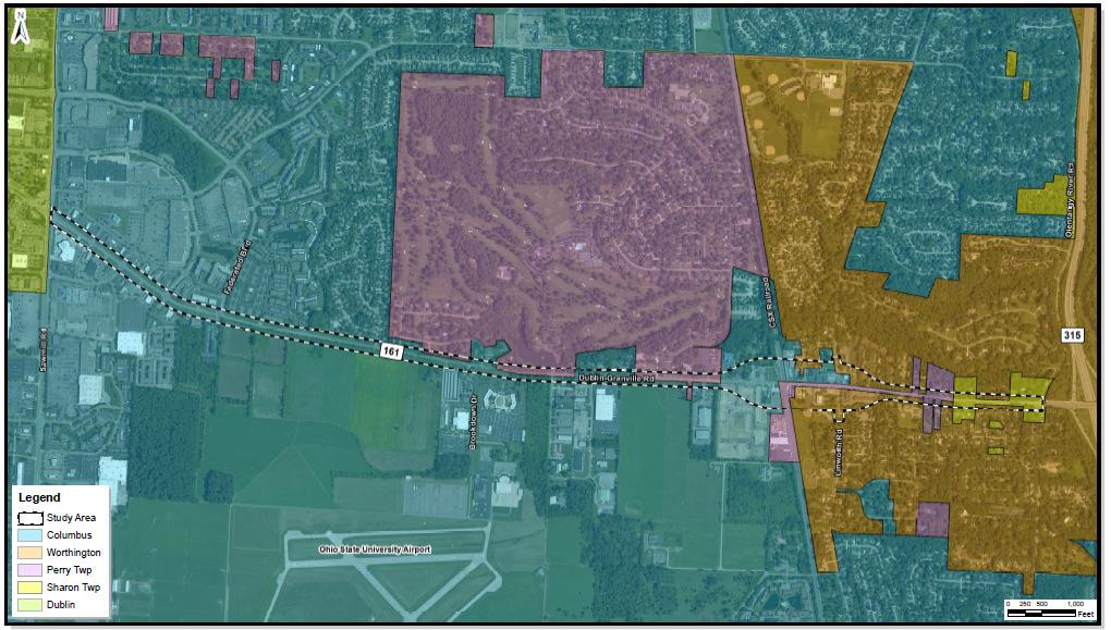
6 Jurisdictions 6
7 Technical Strategy Previous studies ended with no action Public controversy Lack of Funding Different Approach Identify buildable and fundable solutions 7
8 Technical Strategy Advisory Committee Key Milestones Purpose & Need real vs. perceived problems Alternatives Identification, Development & Evaluation Project sections Targeted engineering solution Public Involvement gain support 8
9 Technical Strategy Technical input Traffic projections Capacity analyses Crash analyses Typical sections, footprint and impacts Cost 9

10 Critical Areas 10

11 Business impact example: LinworthLumber 11
12 Public Involvement Advisory Committee Meetings August 2016 Introduction & Input on Problems November 2016 Data Analysis/Transportation Needs January 2017 Alternatives Workshop March 2017 Concept Evaluation part 1 April 2017 Concept Evaluation part 2 July 2017 Public Comments/Proposed Recommendations Public Meeting June
13 Public Involvement Strategy Consensus needed among project partners Buy-in required from constituents Achieved through a transparent process 13
14 Advisory Committee Plan Input from committee at milestones 1. Introduction & Input on Problems 2. Data Analysis/Transportation Needs 3. Development of Alternatives 4. Evaluation of Alternatives 5. Recommendations 14
15 Advisory Committee Membership Diverse perspectives Neighborhood leaders Known advocates Purpose Focus the team s attention on the most relevant data Anticipate issues from the broader community Provide feedback on concepts 15
16 Advisory Committee Participation ODOT MORPC City of Columbus City of Worthington Perry Township Franklin County Engineer s Office City of Dublin The Ohio State University Worthington Bicycle and Pedestrian Advisory Board Worthington Schools Brookside Estates Brookside Woods Northwest Civic Association Olentangy Highlands Plesenton Rau Lane Civic Assoc. Strathaven Westbrook Civic Assoc. Yay Bikes! Safety First 161 Ohio Army National Guard Guests 16
17 Advisory Committee Meeting #1 August 2016 The Agenda: Introductions Team Process Scope Public involvement plan Their role Our goals Begin to establish trust Manage expectations Identify potential conflicts Determine if others should be involved 17
18 Advisory Committee s Role Study and Recommend Mead & Hunt Burgess & Niple Lawhon Inform and Advise Advisory Committee Public Outreach Agency Technical Experts Review and Decide ODOT MORPC Columbus Worthington Franklin County Perry Township 18
19 Advisory Committee Meeting #2 November 2016 Technical Analyses Traffic volumes and growth Congestion Railroad crossing delay Crash history Access issues Bicycle/Pedestrian facilities Our goals All the same from meeting #1, plus Test for understanding Set the stage for Purpose and Need Get a sense of priorities 19
20 Railroad Signal Railroad Crossing Linworth Road 20
21 Crash History Percentage Compared to Statewide Averages for Study Area Injury Rear End Angle Fixed Object Left-Turn Sideswipe-Passing 0% 10% 20% 30% 40% 50% 60% 70% Crash History (Below Average) % Statewide Average % Crash History (Above Average) % 21


22 McVey Boulevard to Linworth Road 18 REAR END CRASHES 0.5 MILE SEGMENT 1.54 MORE CRASHES PER YEAR THAN SIMILAR LOCATIONS CAUSED BY BOTH ACCESS POINTS AND CONGESTION 22


23 Linworth Road to Olentangy River Road 1.45 MORE CRASHES PER YEAR THAN SIMILAR LOCATIONS 15 REAR END CRASHES 0.6 MILE SEGMENT CAUSED BY BOTH ACCESS POINTS AND CONGESTION 3 SIDESWIPE-PASSING CRASHES 23
24 Purpose and Need Primary Needs Reduce vehicular delay at the SR 161/Linworth Intersection Improve pedestrian connectivity and walkability Improve access to/from driveways and side streets Address identified rear-end crash patterns Secondary Needs Reduce delay at rail crossing Improve cycling connectivity and quality 24
25 Advisory Committee Meeting #3 January 2017 Hands-on Workshop Divide into squads Visit each station Develop ideas that should be considered Discuss among your group Tools Aerials (1 = 50 feet) Transparent templates of typical section elements 25
26 Developing Conceptual Alternatives Assign a Squad Leader make sure everyone has opportunity to be heard, keep track of time Assign a Scribe make sure all ideas are recorded on notepads or photographed by the project team Make a list of alternatives that your group would like to see investigated at each station Templates and menus are provided to assist with brainstorming 26
27 Workshop Schedule Period 1-3:45pm Period 2-4:15pm Period 3-4:45pm Squad Station Station Station A West-A Linworth East-A B West-B Linworth East-B C Linworth East-A West-A D Linworth East-B West-B E East-A West-A Linworth F East-B West-B Linworth 27
28 Advisory Committee Meeting #4-A March 2017 Evaluation presentation Analysis highlights Evaluation Open House Mark-ups on exhibits Green/red dots 28
29 Preliminary Concepts The results of the workshop revealed several key decisions for each section of the corridor: 3-lane versus 5-lane Bikelanes/sidewalks versus Shared Use Path/sidewalk If SUP, then which side in what areas Railroad grade separation versus at-grade crossing Overpass versus underpass? Existing location or bypass? Traditional intersection versus non-traditional 22 Concepts 29
30 Intersection Delay and LOS Lane and 5-Lane Morning Peak Lane 31 Seconds in Lane Seconds in 2020
31 Intersection Delay and LOS Lane and 5-Lane Afternoon Peak Lane 36 Seconds in Lane Seconds in 2020
32 Volume Increase from 3-Lane to 5-Lane Based on MORPC s Travel Demand Model
33 Designing for Anticipated Users Bike lanes Transportation Serious riders Shared Use Path Recreation Casual riders 33
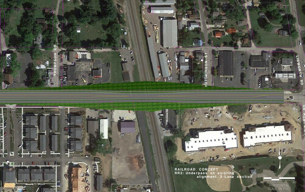
34 Grade separation 34

35 Grade separation on new alignment 35
36 Evaluation Review the Concepts (open-house style) Should any of the concepts be eliminated? Why? Where will we need more information? Mark exhibits for areas of concern Provide feedback to assist in developing comparison matrix 36
37 AC Meeting #4-Part A Comments 3-Lanes or 5-Lanes The use of a 5-lane cross-section does not fit the character of the corridor. No to continuous 5 lanes. 5 lanes between Sawmill and Federated. 37
38 AC Meeting #4-Part A Comments Pedestrian and Bicycle Facilities Prefer SUP to bike lanes. SUP not an ideal solution for bike transportation On road facilities work better. SUP and bike lanes. 38
39 AC Meeting #4-Part A Comments Railroad Crossing Underpass: Worth continuing to study. Overpass: Too much property acquired. No over or under. 39
40 Advisory Committee Meeting #4-B April 2017 Project Team takeaways from AC input Recommended concepts to take to public meeting 40
41 Take-aways Traffic volumes increase by about 30% if additional through lanes are provided (based upon MORPC model) Traffic flow benefit for 161 to adding additional through lanes is partially offset by the traffic growth Traffic benefit may be realized system-wide by removing traffic from other routes Not within the partners intent when initiating the study Not within this project s purpose and need Not quantified in this study 41
42 Take-aways Interest in pedestrian and bicycle facilities in corridor Bike lanes/shared Use Path/Sidewalk Combinations Consensus that it is important No consensus on best way to do it Suggest letting broader public weigh in users and affected property owners 42
43 Take-aways Concern over impacts to residential property Concern over impacts to businesses Request for more information on right-of-way widths 43
 CW1 3 Lane with Buffered Bike Lanes and Sidewalks Both Sides 79 CW2 3 Lane with Shared Use Path on South Side, Sidewalk on North Side 69 CW1/2 3 Lane with")
44 West Corridor ROW Comparisons North CW2 69 CW3 69 CW1 79 CW1/2 85 CW5 91 South CW6 91 CW4 101 Buffers / Curb & Gutter Sidewalk Shared Use Path Tree Lawn Bike Lane Thru Lane / Turning Lane Alternatives Description ROW (in feet) CW1 3 Lane with Buffered Bike Lanes and Sidewalks Both Sides 79 CW2 3 Lane with Shared Use Path on South Side, Sidewalk on North Side 69 CW1/2 3 Lane with Buffered Bike Lanes on Both Sides, Shared Use Path on 85 South Side, Sidewalk on North Side CW3 3 Lane with Sidewalk on South Side, Shared Use Path on North Side 69 CW4 5 Lane with Buffered Bike Lanes and Sidewalks on Both Sides 101 CW5 5 Lane with Shared Use Path on South Side, Sidewalk on North Side 91 CW6 5 Lane with Sidewalk on South Side, Shared Use Path on North Side 91
 CE1 3 Lane with Buffered Bike Lanes and Sidewalks on Both Sides 79 CE2 3 Lane with Shared Use Path on South Side, Sidewalk on North Side 69 CE1/2 3 Lane with Buffered Bike Lanes on Both")
45 East Corridor ROW Comparisons North CE2 69 South CE1 79 CE1/2 85 CE4 91 CE3 101 Buffers / Curb & Gutter Sidewalk Shared Use Path Tree Lawn Bike Lane Thru Lane / Turning Lane Alternatives Description ROW (in feet) CE1 3 Lane with Buffered Bike Lanes and Sidewalks on Both Sides 79 CE2 3 Lane with Shared Use Path on South Side, Sidewalk on North Side 69 CE1/2 3 Lane with Buffered Bike Lanes on Both Sides, Shared Use Path on 85 South Side, Sidewalk on North Side CE3 5 Lane with Buffered Bike Lanes and Sidewalks Both Sides 101 CE4 5 Lane with Shared Use Path on South Side, Sidewalk on North Side 91
46 Take-aways Railroad crossing is a concern But the impacts might outweigh the benefit Need more information to evaluate this 46
47 Public Meeting June 2017 Presented corridor alternatives with 3-lane section plus: Bike lanes and sidewalks both sides Shared-use path on south side, sidewalk on north Bike lanes, shared-use path on south, sidewalk on north Linworth Intersection Concept Railroad underpass And there was much rejoicing. 47
48 Advisory Committee Meeting #5 July 2017 Discuss comments from June 6th public meeting Discuss recommendations of the Study Team Requested feedback for the Partners to consider 48
49 Achieving Consensus Representation Diverse perspectives Opposing/reflecting Context/preparation Pace Transparency 49


50 Next Steps -Funding Strategy Partners adopt study Develop funding strategy for each buildable section Identify sources and apply 50
51 Questions? 51
Lee s Summit Road Improvement Study Public Open House June 7, 2007 Summary of Comment Card Responses
 Lee s Summit Road Improvement Study Public Open House June 7, 2007 Summary of Comment Card Responses Introduction At the Lee s Summit Road Improvement Study Public Open House held Thursday, June 7, 2007
Beach Cities Living Streets Design Manual and Aviation Boulevard Multimodal Corridor Plan
 Beach Cities Living Streets Design Manual and Aviation Boulevard Multimodal Corridor Plan AGENDA 1 Introductions & Project Scope 2 Public Outreach Recap 3 Living Streets Design Manual 4 Aviation Boulevard
GIS Based Non-Motorized Transportation Planning APA Ohio Statewide Planning Conference. GIS Assisted Non-Motorized Transportation Planning
 The Purpose of GIS Assisted Network GIS Assisted Non-Motorized Transportation 2011 APA Ohio Statewide Conference Friday, 10:45 AM to Noon Focus on near-term projects wwwgreenwaycollabcom The purpose of
Technical Working Group November 15, 2017
 Technical Working Group November 15, 2017 Welcome and Introductions Project Partners Regional Transportation District (RTD) Colorado Department of Transportation (CDOT) Denver Regional Council of Governments
WELCOME. Stakeholder Involvement Group Meeting #2 Round Lake Public Works October 24, 2018
 WELCOME Stakeholder Involvement Group Meeting #2 Round Lake Public Works October 24, 2018 MEETING AGENDA 1. Welcome and Introductions 2. Study Progress Update 3. Problem Statement 4. Technical Analysis
BETHEL ROAD AND SEDGWICK ROAD CORRIDOR STUDY
 DRAFT PLAN City Council Meeting August 14, 2017 STUDY AREA Sedgwick Corridor State Route 160, principal arterial with Class 3 access management designation, commuter and freight route, connection to SR
Citizen Advisory Group Meeting #8 May 5, Welcome. Today s meeting will focus on: Land Use & Transportation CHARLOTTEPLANNING.
 Citizen Advisory Group Meeting #8 May 5, 2010 Welcome. Today s meeting will focus on: Land Use & Transportation CHARLOTTEPLANNING.ORG Meeting Agenda Handouts: o Meeting Agenda o Summary of East Seventh
City of Fairfax, Virginia City Council Work Session
 City of Fairfax, Virginia City Council Work Session Agenda Item # 4b City Council Meeting 6/2/2015 TO: FROM: SUBJECT: ISSUE(S): SUMMARY: FISCAL IMPACT: RECOMMENDATION: ALTERNATIVE COURSE OF ACTION: RESPONSIBLE
Ocean Park Boulevard Streetscape Improvement Project Alternatives & Trade Offs
 City Council Study Session January 27, 2009 Ocean Park Boulevard Streetscape Improvement Project Alternatives & Trade Offs Scope of Work Purpose of Tonight s Meeting Review work to date and direct staff
Sandwich Pedestrian/Bicycle Planning
 Sandwich Pedestrian/Bicycle Planning Improved Pedestrian and Bicycle Connections with the Cape Cod Canal Multi-use Path February 2014 Table of Contents Introduction... 1 Background... 1 Study Goals...
Planning Study SR 976. Project Advisory Team Meeting May 24, 2017
 ` SR 976 BIRD ROAD/SW 40TH STREET FROM SR 821/HEFT TO SR 5/US-1 Miami-Dade County, Florida FPID No.: 434845-4-22-01 Planning Study Project Advisory Team Meeting May 24, 2017 1 Agenda Introductions Project
Road Diets FDOT Process
 Florida Department of TRANSPORTATION Road Diets FDOT Process Humberto Castillero, PE, PTOE Roadway Design Office Purpose of Guide Develop a statewide lane elimination review process Balance state & local
City Council Briefing March 18, Draft Working Ideas for Confirmation of Direction
 City Council Briefing March 18, 2014 Draft Working Ideas for Confirmation of Direction Draft Working Ideas for Confirmation of Direction Overall Study Area Regional Population Growth Plan for Today and
GIS Based Data Collection / Network Planning On a City Scale. Healthy Communities Active Transportation Workshop, Cleveland, Ohio May 10, 2011
 The Purpose of GIS Based Network Planning GIS Based Data Collection / Network Planning Healthy Communities Active Transportation Conference Tuesday, May 10, 2011 10:00 AM Norman Cox, LLA, ASLA. Ann Arbor,
CITY OF FRANKLIN, TENNESSEE. Columbia Avenue. Widening & Improvements Project. Public Meeting May 16, 2017
 CITY OF FRANKLIN, TENNESSEE Columbia Avenue Widening & Improvements Project Public Meeting May 16, 2017 Agenda 6:00 6:30 Formal Presentation 6:30 8:00 Town Hall Forum City of Franklin Columbia Avenue Alternatives
M-58 HIGHWAY ACCESS MANAGEMENT STUDY Mullen Road to Bel-Ray Boulevard. Prepared for CITY OF BELTON. May 2016
 M-58 HIGHWAY ACCESS MANAGEMENT STUDY Prepared for CITY OF BELTON By May 2016 Introduction Missouri State Highway 58 (M-58 Highway) is a major commercial corridor in the City of Belton. As development has
Community Task Force March 14, 2018
 Community Task Force March 14, 2018 Welcome and Introductions Project Partners Regional Transportation District (RTD) City of Aurora Colorado Department of Transportation (CDOT) Denver Regional Council
THE ALAMEDA CONCEPT DESIGN COMMUNITY MEETING 3. A Plan for The Beautiful Way JANUARY 28, 2010
 CONCEPT DESIGN COMMUNITY MEETING 3 JANUARY 28, 2010 AGENDA INTRODUCTION COMMUNITY INPUT ROADWAY STUDIES STREETSCAPE DESIGN STATIONS DISCUSSION SUMMARY AND DISCUSSION NEXT STEPS CLOSE INTRODUCTION SCHEDULE
Southbend to Prima Vista. October 30, Floresta Corridor Master Plan
 Application of a Complete Street initiative and how it might function operationally 8 8 Southbend to Prima Vista October 30, 2017 Presentation Agenda 2 Perspective and History Traffic projections, Levels
Application of a Complete Street
 Application of a Complete Street Southbend to Prima Vista Update May 14, 2018 Meeting Agenda Perspective and History Public input received Typical sections being considered Presentation of the 2-lane master
HARRISON STREET/OAKLAND AVENUE COMMUNITY TRANSPORTATION PLAN
 HARRISON STREET/OAKLAND AVENUE Community Workshop #4: Draft Plan Review December 3, 2009 D E S I G N, C O M M U N I T Y & E N V I R O N M E N T INTRODUCTIONS Key Project Staff: Alisa Shen, Project Manager,
Major Bike Routes 102 Avenue Workshop April 21, 2015
 Major Bike Routes 102 Avenue Workshop April 21, 2015 Our Purpose Today Provide context on how Major Bike Routes fit into Edmonton s future Share information on what we heard in our last phase, and how
Board of Supervisors February 27, 2017
 : Traffic Analysis Results & Draft Conceptual Plan Board of Supervisors February 27, 2017 Transportation Solutions Building Better Communities Presentation Overview Background Summary of Traffic Analysis
Chapter 6 Transportation Plan
 Chapter 6 Transportation Plan Transportation Plan Introduction Chapter 6 Transportation Plan Transportation Plan Introduction This chapter describes the components of Arvada s transportation system, comprised
FONTAINE AVENUE STUDY Final Report
 FONTAINE AVENUE STUDY Final Report March 28, 2005 FONTAINE AVENUE STUDY City of Charlottesville March 28, 2005 Renaissance Planning Group Kenneth Schwartz, FAIA, AICP Director of Design Leigh Wilkerson,
ORANGE COUNTY PUBLIC WORKS TRAFFIC INVESTIGATIONS
 ORANGE COUNTY PUBLIC WORKS TRAFFIC INVESTIGATIONS STAFF REPORT OF: January 6, 2019 SUPERVISORIAL DISTRICT: 5 SUBJECT: LOCATION: INVESTIGATOR: O Neill Drive at Roanoke Drive; Ladera Ranch; TB 922-E6 Clever
SR 693 (Pasadena Avenue) Corridor Study from Shore Drive South to 66 th Street
 Corridor Study from Shore Drive South to 66 th Street") Welcome and Introduction Sign-in and comment sheets Restrooms and exits Meeting agenda and timeline Meeting goals / expectations Provide input to guide study recommendations Actively participate throughout
Welcome and Introduction Sign-in and comment sheets Restrooms and exits Meeting agenda and timeline Meeting goals / expectations Provide input to guide study recommendations Actively participate throughout
Complete Streets Process and Case Study: Taft / McMillian Two-Way Street Conversion Cincinnati, Ohio. Traffic Engineering Workshop June 4, 2014
 Complete Streets Process and Case Study: Taft / McMillian Two-Way Street Conversion Cincinnati, Ohio Traffic Engineering Workshop June 4, 2014 Complete Streets Streets that enable safe access for users
Downtown Naples Mobility and Connectivity Study. Naples City Council Presentation January 2017
 Downtown Naples Mobility and Connectivity Study Naples City Council Presentation January 2017 Agenda 1. Introduction 2. Scope Review 3. Project Schedule 4. Existing Conditions 5. Public Charrette 6. Mobility
PROPOSED BICYCLE AND PEDESTRIAN FACILITY Vicinity of Route 123/I-495 Interchange Tysons, Fairfax County, Virginia
 PROPOSED BICYCLE AND PEDESTRIAN FACILITY Vicinity of Route 123/I-495 Interchange Tysons, Fairfax County, Virginia PRELIMINARY ENGINEERING REPORT Prepared for: Prepared by: July 2017 Table of Contents 1
APPENDIX A: Complete Streets Checklist DRAFT NOVEMBER 2016
 APPENDIX A: Complete Streets Checklist DRAFT NOVEMBER 2016 Complete Streets Checklist MetroPlan Orlando s Complete Streets Checklist is an internal planning tool for staff to further implementation of
Ann Arbor Downtown Street Plan
 1 Ann Arbor Downtown Street Plan Public Workshop #1 We know that. 2 Public right-of-way (streets, sidewalks, and alleys) make up 30% of the total District area of downtown. Streets need to provide mobility
Bikeway action plan. Bicycle Friendly Community Workshop March 5, 2007 Rochester, MN
 Bikeway action plan Summary The was held on March 5, 2007 at the Rochester Mayo Civic Center. The workshop was hosted by Rochester-Olmsted County Planning Department in collaboration with the League of
Ocean Park Boulevard Green Street Project Alternatives & Trade Offs
 Planning Commission March 4, 2009 Ocean Park Boulevard Green Street Project Alternatives & Trade Offs Purpose of Tonight s Meeting Review concept plans and options Provide input on alternatives and trade-offs
Executive Summary Route 30 Corridor Master Plan
 Route Corridor Master Plan Project Overview The Route Corridor Master Plan is a coordinated multimodal transportation and land use plan for the entire stretch of Route through East Whiteland Township,
Albany Shaker Road Corridor Study Public Meeting # 2
 Albany Shaker Road Corridor Study Public Meeting # 2 Scope / Meeting Purpose This project is a CDTC Linkage Study. The Linkage Program is designed to implement the adopted planning and investment principles
Active Transportation Facility Glossary
 Active Transportation Facility Glossary This document defines different active transportation facilities and suggests appropriate corridor types. Click on a facility type to jump to its definition. Bike
City of Wilsonville 5 th Street to Kinsman Road Extension Project
 City of Wilsonville 5 th Street to Kinsman Road Walking Tour & Neighborhood Workshop Summary Report Public Outreach Overview On July 18 th, 2017, the City of Wilsonville hosted a neighborhood walking tour
Community Task Force November 15, 2017
 Community Task Force November 15, 2017 Welcome and Introductions Project Partners Regional Transportation District (RTD) Colorado Department of Transportation (CDOT) Denver Regional Council of Governments
MAG Town of Cave Creek Bike Study Task 6 Executive Summary and Regional Significance Report
 Page 1 MAG Town of Cave Creek Bike Study Task 6 Executive Summary and Regional Significance Report August 1, 2012 MAG Project #481 Page 2 Task 6 Executive Summary and Regional Significance Report Introduction
TRANSPORTATION NEEDS ASSESSMENT
 TRANSPORTATION NEEDS ASSESSMENT A travel demand analysis was carried out to determine the operational issues and the potential benefit that adding traffic capacity would have on the road network. All the
FM 1092/Murphy Road Access Management Study Pulic Meeting #1. Wednesday, August 31, :00 p.m. 8:00 p.m.
 FM 1092/Murphy Road Access Management Study Pulic Meeting #1 Wednesday, August 31, 2011 6:00 p.m. 8:00 p.m. Introductions Agency Partners H-GAC Missouri City TxDOT Introductions Consulting Team In Association
JONESBORO HIGHWAY 63 HIGHWAY 18 CONNECTOR STUDY
 JONESBORO HIGHWAY 63 HIGHWAY 18 CONNECTOR STUDY Craighead County May 2007 JONESBORO HIGHWAY 63 HIGHWAY 18 CONNECTOR STUDY Craighead County May 2007 Prepared by Planning and Research Division Arkansas State
COWETA HIGH SCHOOL AND EAST HIGHWAY 51
 COWETA HIGH SCHOOL AND EAST HIGHWAY 51 Lack of sidewalks along Ben Lumpkin Rd. Lack of crosswalks and ramps at intersection. Hwy 51 is wide to cross as a pedestrian. No ADA compliance or connection to
5/31/2016 VIA . Arwen Wacht City of Sacramento Community Development Department 300 Richards Blvd., 3 rd Floor Sacramento, CA 95811
 5/31/2016 VIA EMAIL Arwen Wacht City of Sacramento Community Development Department 300 Richards Blvd., 3 rd Floor Sacramento, CA 95811 RE: El Pollo Loco (P16-028) Dear Ms. Wacht: WALKSacramento has reviewed
Houma-Thibodaux Metropolitan Planning Organization STP<200K Funding Application APPLICATION
 APPLICATION HOUMA-THIBODAUX METROPOLITAN PLANNING ORGANIZATION (HTMPO) FOR SURFACE TRANSPORTATION PROGRAM (STP
ADOT Statewide Bicycle and Pedestrian Program Summary of Phase IV Activities APPENDIX B PEDESTRIAN DEMAND INDEX
 ADOT Statewide Bicycle and Pedestrian Program Summary of Activities APPENDIX B PEDESTRIAN DEMAND INDEX May 24, 2009 Pedestrian Demand Index for State Highway Facilities Revised: May 29, 2007 Introduction
Report. Typical Sections. City of Middleton, WI
 Report Typical Sections City of Middleton, WI December 2006 Report for City of Middleton, Wisconsin Typical Sections repared by: Traffic Associates LLC and STRAND ASSOCIATES, INC. 910 West Wingra Drive
Community Advisory Committee
 Community Advisory Committee Meeting #1 November 19, 2014 Presentation Team Matt Fulda, Greater Bridgeport Regional Council Chris Granatini, P.E., Tighe & Bond Craig Yannes, P.E., PE PTOE, Tighe & Bond
APPENDIX D. May 22, 2002 Open House Summary and Materials
 APPENDIX D May 22, 2002 Open House Summary and Materials TH 36 Partnership Study Open House May 22, 2002 Summary of Survey Responses 1. If no new crossing of the St. Croix River is built (e.g. the existing
Bus Rapid Transit ALTERNATIVES ANALYSIS. Open House
 Bus Rapid Transit ALTERNATIVES ANALYSIS Open House June 23, 2015 Open House Meeting Agenda Agenda Introductions What is BRT? Project Goals Study Tasks Next steps Discussion PVTA Bus Rapid Transit Study
METHODOLOGY. Signalized Intersection Average Control Delay (sec/veh)
") Chapter 5 Traffic Analysis 5.1 SUMMARY US /West 6 th Street assumes a unique role in the Lawrence Douglas County transportation system. This principal arterial street currently conveys commuter traffic
Chapter 5 Traffic Analysis 5.1 SUMMARY US /West 6 th Street assumes a unique role in the Lawrence Douglas County transportation system. This principal arterial street currently conveys commuter traffic
ITE Northeastern District Meeting
 West Hartford Road Diet and Safety Study ITE Northeastern District Meeting Session 2A Complete Streets May 22, 2018 North Main St. - Classified as a principal arterial But provides high levels of access
Environmental Assessment Findings & Recommendations. Public Hearing November 13, 2014
 Environmental Assessment Findings & Recommendations Public Hearing November 13, 2014 Welcome! Welcome and Introductions Project and Environmental Assessment Overview Public Comments Adjourn Purpose of
Vision: Traditional hamlet with an attractive business/pedestrian friendly main street connected to adjacent walkable neighborhoods
 N D. Focus Area II Vision: Traditional hamlet with an attractive business/pedestrian friendly main street connected to adjacent walkable neighborhoods Transit Road Focus Area II is located in the Hamlet
DEPARTMENT OF ENVIRONMENTAL SERVICES. North Harrison Street (Lee Highway to Little Falls Road) Comparative Analysis. Prepared for:
 Comparative Analysis. Prepared for:") DEPARTMENT OF ENVIRONMENTAL SERVICES North Harrison Street (Lee Highway to Little Falls Road) Comparative Analysis Prepared for: Arlington County Department of Environmental Services 2100 Clarendon Boulevard,
DEPARTMENT OF ENVIRONMENTAL SERVICES North Harrison Street (Lee Highway to Little Falls Road) Comparative Analysis Prepared for: Arlington County Department of Environmental Services 2100 Clarendon Boulevard,
Atwood Avenue Fair Oaks Avenue Cottage Grove Road
 Atwood Avenue Fair Oaks Avenue Cottage Grove Road Agenda Purpose Review project scope & goals Present design alternatives Gather feedback Answer Questions Format Open House Presentation Q&A Open House
5. RUNNINGWAY GUIDELINES
 5. RUNNINGWAY GUIDELINES These guidelines should be considered collectively when making runningway decisions. A runningway is the linear component of the transit system that forms the right-of-way reserved
Modal Interrelationships: A bicycle lane is proposed between Harrington Ave and Swanns Station Rd.
 DRAFT PROJECT PAGE July 12, 2007 Main St / Broadway Rd (SR 1579) Project Statement Project Recommendation: From Avent Ferry Rd (NC 42) to the Harnett County line, Broadway Rd/Main St is recommended to
Click to edit Master title style
 Route N Study Community Advisory Group (CAG) Meeting #2 December 12, 2018 Click Agenda to edit Master title style Introductions Recap of the CAG Meeting #1 and Public Meeting #1 Purpose & Need Review Review
City of Sammamish. Welcome. Issaquah-Fall City Road Improvements Project Phase I Design: 242nd Avenue SE to Klahanie Drive SE
 Welcome Welcome to the third community meeting for the Issaquah-Fall City Road Improvements Project. AGENDA 6:00 p.m. Welcome and sign-in 6:10 p.m. Presentation 6:50 p.m. Open house Learn about the roadway
Basalt Creek Transportation Refinement Plan Recommendations
 Basalt Creek Transportation Refinement Plan Recommendations Introduction The Basalt Creek transportation planning effort analyzed future transportation conditions and evaluated alternative strategies for
MAYFIELD ROAD CORRIDOR MULTIMODAL TRANSPORTATION PLAN. Public Workshop
 MAYFIELD ROAD CORRIDOR MULTIMODAL TRANSPORTATION PLAN Public Workshop 06.06.18 AGENDA Project Process & Schedule Document Review Summary Project Goals Initial Findings Concept Development Next Steps PROJECT
University of Victoria Campus Cycling Plan Terms of Reference. 1.0 Project Description
 University of Victoria Campus Cycling Plan Terms of Reference 1.0 Project Description The Campus Cycling Plan, a first for the University, will provide a comprehensive and coordinated approach to support
Information on display. Inside this handout. Triangle Area revisions. Project need displays. Preferred alternative on aerial maps
 Public information meeting #4 4 to 7 p.m., September 30, 2009 Hales Corners Welcome Thank you for attending this public information meeting for the WIS 100 Corridor Study. Your interest and comments are
McGrath Boulevard Project Development Public Meeting #2 May 28 th, 2015 East Somerville Community School
 McGrath Boulevard Project Development Public Meeting #2 May 28 th, 2015 East Somerville Community School Agenda Introductions Project Context Current Construction McGrath Boulevard Project Development
Colchester/Riverside/Barrett/ Mill Intersection Study. PAC Meeting #3 September 22, 2016
 Colchester/Riverside/Barrett/ Mill Intersection Study PAC Meeting #3 September 22, 2016 Tonight s Agenda Review Project Purpose and Need Describe short term and long improvements and changes since public
MASTER BICYCLE AND PEDESTRIAN PLAN
 VILLAGE OF NORTHBROOK MASTER BICYCLE AND PEDESTRIAN PLAN DRAFT PLAN OPEN HOUSE May 2, 2018 AGENDA 1. Community Engagement 2. Vision and Goals 3. General Structure of Plan 4. Recommendations Overview 5.
10/8/2014 VIA . RE: CVS Pharmacy (P13-002) Revised August 2014
 Revised August 2014") 10/8/2014 VIA EMAIL David Hung, Associate Planner Community Development Department, Current Planning Division City of Sacramento 300 Richards Boulevard, 3 rd Floor Sacramento, CA 95811 RE: CVS Pharmacy
10/8/2014 VIA EMAIL David Hung, Associate Planner Community Development Department, Current Planning Division City of Sacramento 300 Richards Boulevard, 3 rd Floor Sacramento, CA 95811 RE: CVS Pharmacy
CONNECTIVITY PLAN. Adopted December 5, 2017 City of Virginia Beach
 CONNECTIVITY PLAN Adopted December 5, 2017 City of Virginia Beach CONTENTS 1.0 Background & Purpose... 2 2.0 Existing Inventory & Analysis... 3 ViBe District Existing Walking Conditions... 4 3.0 ViBe District
Meade Street Bridge Design Alternative Study
 Meade Street Bridge Design Alternative Study Preferred Alternative Presentation Stakeholder Meeting #3 June 23, 2011 Presented by: Dan Biggs, RLA Meeting Agenda Purpose: 1. Review Meeting #2 Feedback 2.
INTRODUCTION THOROUGHFARE SYSTEM CLASSIFICATIONS
 INTRODUCTION The thoroughfare plan will assist public officials in the development of a specialized system for efficient and safe movement of vehicular traffic while minimizing potential conflicts with
PROJECT BACKGROUND/DESCRIPTION
 SCOPE OF SERVICES St. Charles Parish Comprehensive Pedestrian and Bicycle Master Plan (CPBP) St. Charles Parish, Louisiana State Project No. H. 012462 RPC Project No. SCPBMP1 PROJECT BACKGROUND/DESCRIPTION
Evaluation of M-99 (Broad Street) Road Diet and Intersection Operational Investigation
 Road Diet and Intersection Operational Investigation") Evaluation of M-99 (Broad Street) Road Diet and Intersection Operational Investigation City of Hillsdale, Hillsdale County, Michigan June 16, 2016 Final Report Prepared for City of Hillsdale 97 North Broad
Evaluation of M-99 (Broad Street) Road Diet and Intersection Operational Investigation City of Hillsdale, Hillsdale County, Michigan June 16, 2016 Final Report Prepared for City of Hillsdale 97 North Broad
6/22/2018 VIA . Darcy Goulart, Planning Manager City of Rancho Cordova Planning Department 2729 Prospect Park Drive Rancho Cordova, CA 95670
 6/22/2018 VIA EMAIL Darcy Goulart, Planning Manager City of Rancho Cordova Planning Department 2729 Prospect Park Drive Rancho Cordova, CA 95670 RE: Quick Quack Car Wash (DD9801) Dear Ms. Goulart: WALKSacramento
TRANSPORTATION FACILITY PLANNING Waugh Chapel Road Maytime Drive to New Market Lane
 July 24, 2018 TRANSPORTATION FACILITY PLANNING Waugh Chapel Road Maytime Drive to New Market Lane DPWandYOU.com Making a difference, together Meeting Agenda Purpose of the project Overview of work conducted
Bellevue Downtown Association Downtown Bike Series
 Bellevue Downtown Association Downtown Bike Series Meeting 2 Franz Loewenherz Andreas Piller Kyle Potuzak Chris Long October 26, 2017 Today s Agenda: 1) Meeting Purpose 2) 9/28 Meeting Recap 3) Candidate
Paoli Road Improvement Feasibility Study
 Paoli Road Improvement Feasibility Study & Public Participation Project March 24, 2015 Prepared for: Tredyffrin Township Prepared by: McMahon Associates, Inc. with Town Planning Partnership, LLC Glackin
Montgomery Road Project Stakeholder Focus Group Meeting # 1 January 29, 2014
 Stakeholder Focus Group (SFG) Meeting #1: The first SFG meeting for the Montgomery Road Study was held on at the Montgomery Village Hall, 200 N. River Street, in Montgomery, Illinois from 2:00-4:00 PM.
CSAH 101 Preliminary Design
 CSAH 101 Preliminary Design Public Open House No. 2 January 29, 2013 CSAH 62 to Hutchins Drive Welcome / Introductions Hennepin County Craig Twinem, Transportation Maury Hooper, Transportation Nick Peterson,
REGIONAL BICYCLE AND PEDESTRIAN DESIGN GUIDELINES
 REGIONAL BICYCLE AND PEDESTRIAN DESIGN GUIDELINES November 16, 2011 Deb Humphreys North Central Texas Council of Governments Bicycle and Pedestrian Advisory Committee Snapshot of the Guide 1. Introduction
TRANSPORTATION COMMISSION Agenda Staff Report
 TRANSPORTATION COMMISSION Agenda Staff Report Agenda Item No. 5.a DATE: JULY 31, 2014 TO: FROM: SUBJECT: TRANSPORTATION COMMISSION COMMUNITY DEVELOPMENT DEPARTMENT - PLANNING DRAFT OLYMPIC CORRIDOR PREFERRED
Los Altos Hills Town Council - June 18, 2015 Palo Alto City Council June 22, AGENDA ITEM #2.B Presentation
 Los Altos Hills Town Council - June 18, 2015 Palo Alto City Council June 22, 2015 AGENDA ITEM #2.B Presentation Previous Presentations Los Altos Hills Town Council in May 2014 and February 2015 Palo Alto
Houma-Thibodaux Metropolitan Planning Organization STP<200K Funding Application APPLICATION
 APPLICATION HOUMA-THIBODAUX METROPOLITAN PLANNING ORGANIZATION (HTMPO) FOR SURFACE TRANSPORTATION PROGRAM (STP
Moving Together Conference Complete Streets from the MassDOT District 5 Perspective
 Moving Together Conference Complete Streets from the MassDOT District 5 Perspective Timothy Kochan, Transportation Planner and Bicycle/ Pedestrian Coordinator District 5 Office Taunton S Overview of District
Broad Street Bicycle Boulevard Design Guidelines
 Broad Street Bicycle Boulevard Design Guidelines Building from the strategies introduced in the 2013 Bicycle Transportation Plan and community input received thus far, City Transportation Staff have identified
Route 29 Corridor Assessment Update. Development of Possible Solutions
 Route 29 Corridor Assessment Update Development of Possible Solutions Public Workshop #3 October 27, 2016 Purpose of Developing Possible Solutions Recap of where we ve been and timeline for moving forward
CITY OF BLOOMINGTON COMPLETE STREETS POLICY
 CITY OF BLOOMINGTON COMPLETE STREETS POLICY POLICY OBJECTIVE: The City of Bloomington will enhance safety, mobility, accessibility and convenience for transportation network users of all ages and abilities,
Community Task Force July 25, 2017
 Community Task Force July 25, 2017 Welcome and Introductions Project Partners Regional Transportation District (RTD) Colorado Department of Transportation (CDOT) Denver Regional Council of Governments
Complete Streets Policy DAVID CRONIN, P.E., CITY ENGINEER
 Complete Streets Policy DAVID CRONIN, P.E., CITY ENGINEER Complete Streets City Commission adopted a Complete Streets policy in 2012 Complete Streets are road networks that are designed for all users:
Owl Canyon Corridor Project Overview and Summary
 Owl Canyon Corridor Project Overview and Summary December 22, 2008 The Owl Canyon corridor (generally the connection between the I-25 / Larimer County Road 70 interchange and the US 287 / Larimer County
Traffic Analysis and Design Report. NW Bethany Boulevard. NW Bronson Road to NW West Union Road. Washington County, Oregon
 Traffic Analysis and Design Report NW Bethany Boulevard NW Bronson Road to NW West Union Road Washington County, Oregon May 2011 Table of Contents Table of Contents Section 1 Executive Summary... 2 Section
Corridor Studies. LA 415 and LA 73
 Corridor Studies LA 415 and LA 73 Project Approach for Both Corridors 1. Data Collection 2. Data Summary 3. Traffic Analysis 4. Micro-Simulation modeling 5. Generation of alternatives 6. Modeling alternatives
Project Development & Environment (PD&E) Study. November 17, SR 90 (SW 8th Street and SW 7th Street) SW 8 th Street/SW 7 th Street PD&E Study 1
 Study. November 17, SR 90 (SW 8th Street and SW 7th Street) SW 8 th Street/SW 7 th Street PD&E Study 1") Financial Management Number: 432639-6-22-01 Federal Aid Project Number: 0202-054-P Efficient Transportation Decision Making Number: 14230 Project Development & Environment (PD&E) Study SR 90 (SW 8th Street
Financial Management Number: 432639-6-22-01 Federal Aid Project Number: 0202-054-P Efficient Transportation Decision Making Number: 14230 Project Development & Environment (PD&E) Study SR 90 (SW 8th Street
Meeting Schedule 7:00-7:15 Open House 7:15-7:45 Existing Conditions/Short-Term Improvements Study Presentation 7:45-8:00 Q&A Session 8:00-8:10
 Meeting Schedule 7:00-7:15 Open House 7:15-7:45 Existing Conditions/Short-Term Improvements Study Presentation 7:45-8:00 Q&A Session 8:00-8:10 Long-Term Study Presentation 8:10-8:40 Table Discussions 8:40-9:00
Southview Blvd & 3 rd Avenue Improvement Project. Public Open House December 4, to 7pm
 Southview Blvd & 3 rd Avenue Improvement Project Public Open House December 4, 2014 5 to 7pm Southview Blvd & 3 rd Avenue Public Information Meeting Agenda Presentation 5:30 to 6:15 pm Purpose of Project
9/22/2014 VIA . RE: Butano Apartments Pre App (PAMP )
") 9/22/2014 VIA EMAIL Surinder Singh, Senior Planner Planning and Environmental Review Division Sacramento County 827 7th Street, Second Floor RE: Butano Apartments Pre App (PAMP2014-00012) Dear Mr. Singh:
9/22/2014 VIA EMAIL Surinder Singh, Senior Planner Planning and Environmental Review Division Sacramento County 827 7th Street, Second Floor RE: Butano Apartments Pre App (PAMP2014-00012) Dear Mr. Singh:
TRANSPORTATION & MOBILITY VISIONING MEETING. August 23 24, 2017
 TRANSPORTATION & MOBILITY VISIONING MEETING August 23 24, 2017 Project Team 1999 South Lakefront Framework Plan In 1999, the Chicago Park District authorized framework plans for three historic parks: Jackson,
Chapter 4 Traffic Analysis
 Chapter 4 Traffic Analysis PURPOSE The traffic analysis component of the K-68 Corridor Management Plan incorporates information on the existing transportation network, such as traffic volumes and intersection
Safe Streets. City of Lake Forest Park. March 21, 2017
 Safe Streets City of Lake Forest Park March 21, 2017 1 01 WELCOME 2 Agenda WELCOME WHAT IS THIS PROJECT? CONTEXT DRAFT CITYWIDE PROJECTS EXERCISE INTRODUCTION 3 02 WHAT IS THIS PROJECT? 4 WHAT IS THIS