2016 TRI-CITY AREA SINGLE OCCUPANT AND HIGH OCCUPANT WINDSHIELD SURVEY
|
|
|
- Pierce Banks
- 6 years ago
- Views:
Transcription

1
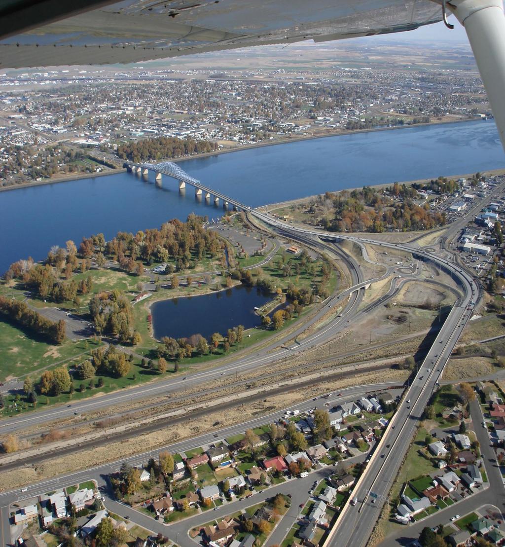
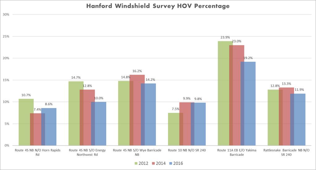
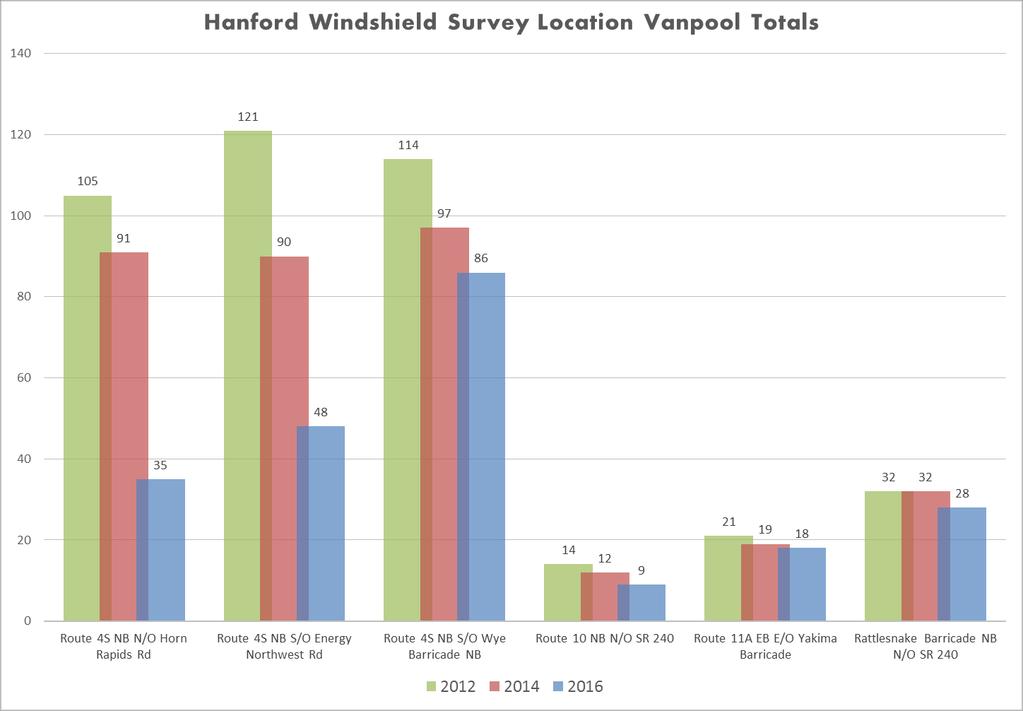
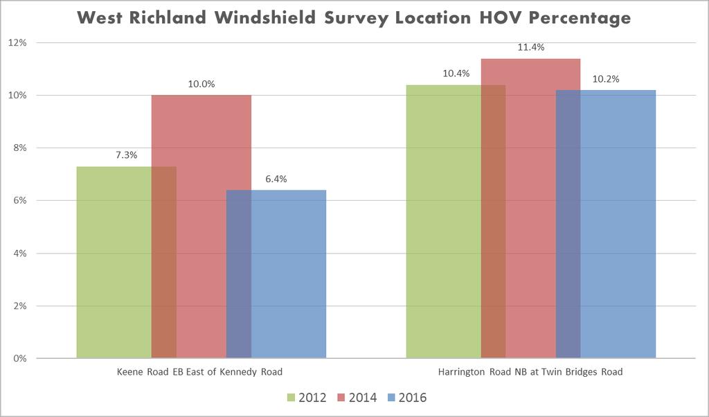
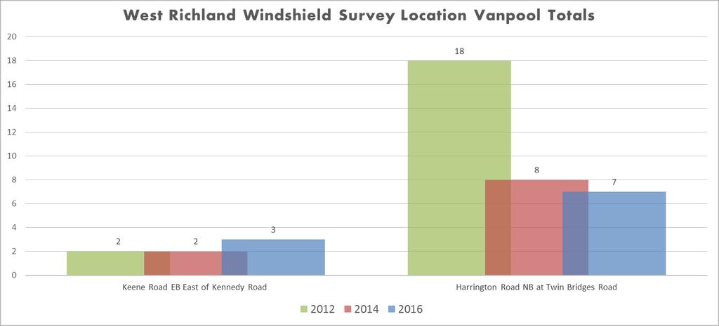
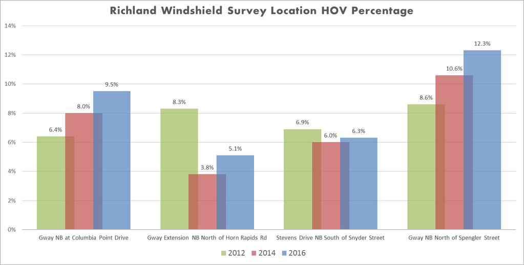
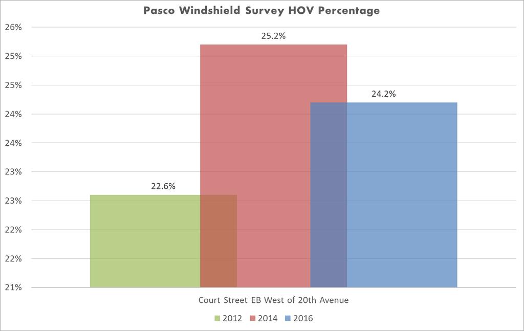
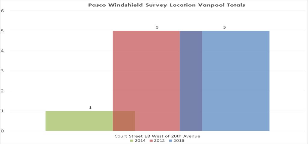
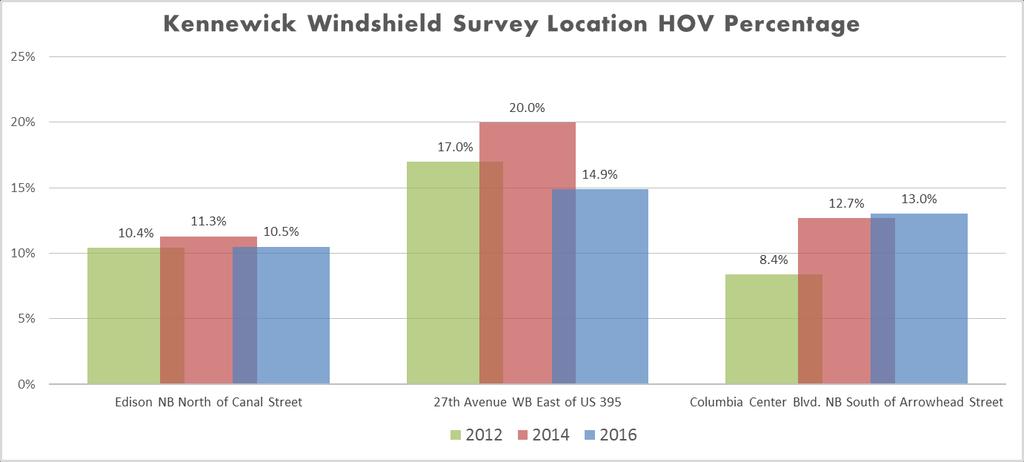
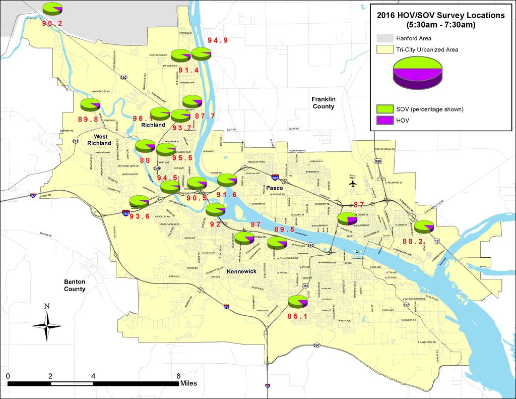
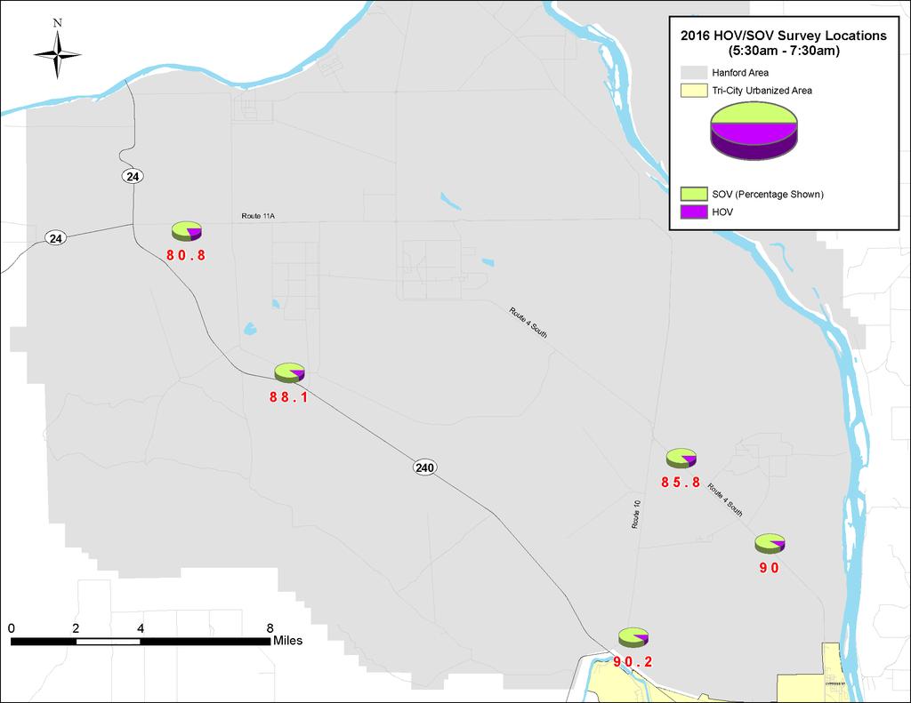
2 2016 TRI-CITY AREA SINGLE OCCUPANT AND HIGH OCCUPANT WINDSHIELD SURVEY In mid-may, the BFCG Transportation Programs office coordinated a windshield survey aimed at providing Single Occupancy Vehicles (SOV) and High Occupancy Vehicles (HOV) rates throughout the Tri-City Area. The survey is conducted every two years with data available at various locations dating back to Surveys were completed at select spots along major commute corridors, and at primary access points to the Hanford Site. BFCG staff wants to express their appreciation to WSDOT, Mission Support Alliance (MSA), and the cities of Kennewick, Pasco, Richland, and West Richland for their help in providing staff time toward this effort. In total, surveyors were able to collect SOV/HOV occupancy rates at twenty-three locations in our region. The SOV/HOV data is an important indicator of occupancy travel patterns for the area s Transportation Demand Management (TDM) program as well as calibrating the local Travel Model. Data was collected in fifteen minute increments between 5:30am -7:30am May 17 th & 18 th with surveyors tallying singleoccupant vehicles, high-occupant vehicles (2, or more persons), and vanpools SOV/HOV Survey Locations: Hanford Area Route 4S north bound, north of Horn Rapids Rd Route 4S north bound, south of Energy Northwest Rd Route 4S north bound, south of Wye Barricade Route 10 north bound, north of State Route 240 Route 11A east bound, east of Yakima Barricade Rattlesnake Barricade north bound, north of State Route 240 City of Richland George Washington Way Extension north bound, north of Horn Rapids Rd George Washington Way north bound, at Columbia Point Dr Stevens Dr north bound, south of Snyder Rd George Washington Way north bound, north of Spengler St City of Kennewick Columbia Center Boulevard north bound, south of Arrowhead Ave Edison St north bound, north of Canal Dr 27 th west bound, east of US 395 City of Pasco US 12 west bound, west of A St Court St east bound, west of 20 th Ave BFCG (WSDOT State Routes) State Route 240 west bound, south of Duportail St State Route 224 (Van Giesen) east bound, east of Jones Rd State Route 240 west bound, south of Robertson Rd WSDOT I 182 west bound at Columbia River Bridge, west of Road 100 State route 240 (causeway) west bound, at Yakima River Bridge State route 240 west bound, south of State Route 224 (Van Giesen) West Richland Keene Rd east bound, east of Kennedy Rd Harrington Rd north bound, at Twin Bridges Rd 2016 Survey Results (EB = East Bound, WB = West Bound, SB = South Bound, NB = North Bound) (N/O = North of, S/O =South of, W/O = West of, E/O = East of) 1
3 2
4 3
5 4
6 5
7 6
8 7
9 8
10 9

11 10 Gasoline Price Chart
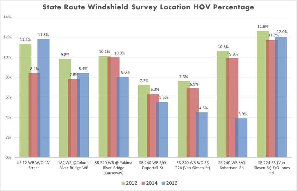
 and Robertson Road (10.6% in 2012, 3.9% in 2016).")
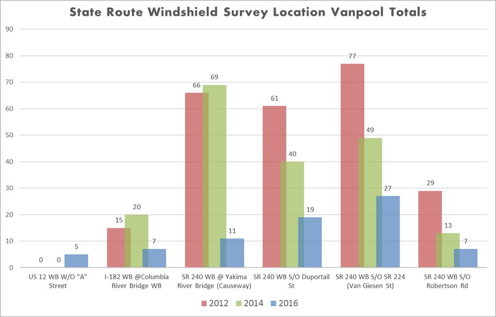
12 2016 HOV/SOV Observations WSDOT State Routes In August 2014, all Hanford are employees switched to a 6:00 a.m. to 4:30 p.m. shift. There is a considerable drop in HOV at the SR 240 locations at Van Giesen (7.6% in 2012, 4.5% in 2016) and Robertson Road (10.6% in 2012, 3.9% in 2016). The SR 240 bypass South of Duportail and south of Van Giesen also had their peak time shifted one half hour earlier to 5:30 a.m. 6:30 a.m. in Hanford Area The 2016 Vanpool counts were drastically lower (143 less) at the Route 4S locations (Horn Rapids Road and Energy Northwest Road) than in West Richland Keene Road EB East of Kennedy Road dropped in 2016 HOV percentage by 3.6% form Richland All of Richland s survey locations rose in HOV percentage over 2014 by 4.8%. Vanpools The most obvious downturn was in the vanpool program. With the closure of the Umatilla Weapons Depot in 2012 and lower gas prices there has been a significant drop in ridership in 2014 and
13 HISTORICAL SOV/HOV TRAFFIC SURVEY RESULTS LOCATION YEAR* Time Period Tot Vol Tot SOV Tot HOV % SOV % HOV Vanpool Peak Hr Peak Vol Peak SOV * Surveys conducted on weekday mornings during May of the noted year. STATE HIGHWAYS US 12 WB W/O "A" Street Peak Hr % SOV Peak HOV Some locations reflect higher HOV rates due to home-to-school trips observed - noticable between the 7:15-8am time period. Those locations noted with "HOV/Students" in the comments column :30-7:30 am % 11.8% 5 6:30-7:30 am % % :30-7:30 am % 8.4% 0 6:30-7:30 am % % :30-7:30 am % 11.3% 0 6:30-7:30 am % % :00-8:00 am % 12.3% 1 7:00-8:00 am % % :00-8:30 am % 15.9% 7:00-8:00 am % % I-182 River Bridge WB :30-7:30 am % 8.4% 7 6:30-7:30 am % % :30-7:30 am % 7.8% 20 6:30-7:30 am % % 2 Volumes without Road 100 ramp traffic :30-7:30 am % 9.8% 15 6:30-7:30 am % % :00-8:00 am % 8.6% 9 7:00-8:00 am % % :00-8:00 am % 12.7% 7:00-8:00 am % % :30-8:00 am % 10.1% 6:30-7:30 am % % Peak Hr % HOV Vanpool Comments SR 240 Yakima River Bridge (Causeway) SR 240 WB S/O Duportail St SR 240 WB S/O SR 224 (Van Giesen St) SR 240 WB N/O SR 224 (Van Giesen St) SR 240 WB S/O Robertson Rd SR 224 EB (Van Giesen St) E/O Jones Rd :30-7:30 am % 8.0% 11 6:30-7:30 am % % :30-7:30 am % 10.0% 69 6:30-7:30 am % % :30-7:30 am % 10.1% 66 6:30-7:30 am % % :00-8:00 am % 8.4% 40 6:15-7:15 am % % 10 HOV/Students :00-8:00 am % 13.6% 6:30-7:30 am % % HOV/Students :00-8:00 am % 10.1% 6:15-7:15 am % % HOV/Students :30-7:30 am % 5.5% 19 5:30-6:30 am % % :30-7:30 am % 6.3% 40 6:00-7:00 am % % :30-7:30 am % 7.2% 61 6:00-7:00 am % % 31 HOV/Students :00-8:00 am % 9.5% 39 6:00-7:00 am % % 35 HOV/Students :00-8:00 am % 8.1% 6:00-7:00 am % % HOV/Students :30-8:00 am % 8.3% 6:00-7:00 am % % HOV/Students :00-8:00 am % 9.4% 6:00-7:00 am % % :00-8:00 am % 8.1% 6:00-7:00 am % % :00-8:00 am % 9.2% 6:00-7:00 am % % :30-7:30 am % 4.5% 27 5:30-6:30 am % % :30-7:30 am % 6.9% 49 6:00-7:00 am % % :30-7:30 am % 7.6% 77 6:00-7:00 am % % :00-8:00 am % 7.5% 40 6:00-7:00 am % % :00-8:00 am % 8.1% 6:00-7:00 am % % :30-8:00 am % 8.2% 6:15-7:15 am % % :30-8:00 am % 8.2% 6:15-7:15 am % % HOV/Students :00-8:00 am % 10.6% 6:00-7:00 am % % :00-8:00 am % 10.4% 6:00-7:00 am % % :00-8:00 am % 12.1% 6:00-7:00 am % % :30-7:30 am % 3.9% 7 6:00-7:00 am % % :30-7:30 am % 9.9% 13 6:00-7:00 am % % :30-7:30 am % 10.6% 29 6:00-7:00 am % % :00-8:00 am % 12.8% 35 6:00-7:00 am % % :00-8:00 am % 17.3% 6:00-7:00 am % % :30-7:30 am % 10.7% 6:00-7:00 am % % :00-8:00 am % 14.7% 6:00-7:00 am % % :00-8:00 am % 17.2% 6:00-7:00 am % % :30-7:30 am % 12.0% 0 6:30-7:30 am % % :30-7:30 am % 11.7% 1 6:30-7:30 am % % :30-7:30 am % 12.6% 0 6:30-7:30 am % % 0 HOV/Students :00-8:00 am % 15.3% 2 7:00-8:00 am % % 0 HOV/Students BENTON - FRANKLIN REGIONAL TRANSPORTATION PLANNING ORGANIZATION
14 HISTORICAL SOV/HOV TRAFFIC SURVEY RESULTS LOCATION YEAR* Time Period Tot Vol Tot SOV Tot HOV % SOV % HOV Vanpool Peak Hr Peak Vol Peak SOV * Surveys conducted on weekday mornings during May of the noted year. KENNEWICK Edison NB N/O Canal Peak Hr % SOV Peak HOV Some locations reflect higher HOV rates due to home-to-school trips observed - noticable between the 7:15-8am time period. Those locations noted with "HOV/Students" in the comments column. Peak Hr % HOV Vanpool Comments :00-8:00 am % 12.6% 6:45-7:45 am % % HOV/Students :30-8:00 am % 15.9% 6:45-7:45 am % % HOV/Students :00-8:00 am % 18.6% 7:00-8:00 am % % :30-7:30 am % 10.5% 3 6:30-7:30 am % % :30-7:30 am % 11.3% 6 6:30-7:30 am % % :30-7:30 am % 10.4% 12 6:30-7:30 am % % :00-8:00 am % 10.3% 6 7:00-8:00 am % % 0 HOV/Students :00-8:30 am % 11.1% 7:00-8:00 am % % :00-8:00 am % 9.2% 7:00-8:00 am % % WB 27th Avenue E/O US :30-7:30 am % 14.9% 0 6:30-7:30 am % % :30-7:30 am % 20.0% 6 6:30-7:30 am % % :30-7:30 am % 17.0% 17 6:30-7:30 am % % 8 HOV/Students :00-8:00 am % 20.2% 1 7:00-8:00 am % % 1 HOV/Students :00-8:30 am % 21.7% 7:00-8:00 am % % HOV/Students Columbia Center Blvd. NB S/O Arrowhead PASCO Court Street EB W/O 20th Avenue RICHLAND GW Way NB at Columbia Point Dr George Washington Way NB N/O Comstock GW Way Extension NB N/O Horn Rapids Rd Stevens Dr NB S/O Snyder Rd :30-7:30 am % 13.0% 3 6:30-7:30 am % % :30-7:30 am % 12.7% 4 6:30-7:30 am % % :30-7:30 am % 8.4% 11 6:30-7:30 am % % :00-8:00 am % 11.2% 2 7:00-8:00 am % % 0 HOV/Students :00-8:30 am % 12.8% 7:30-8:30 am % % HOV/Students :00-8:00 am % 12.0% 7:00-8:00 am % % :30-7:30 am % 24.2% 5 6:30-7:30 am % % :30-7:30 am % 25.2% 1 6:30-7:30 am % % :30-7:30 am % 22.6% 5 6:30-7:30 am % % :00-8:00 am % 21.9% 1 7:00-8:00 am % % 0 HOV/Students :00-8:30 am % 24.4% 7:30-8:30 am % % HOV/Students :30-7:30 am % 9.5% 17 6:30-7:30 am % % :30-7:30 am % 8.0% 10 6:30-7:30 am % % :30-7:30 am % 6.4% 14 6:30-7:30 am % % :00-8:00 am % 8.1% 22 6:30-7:30 am % % :00-8:00 am % 5.0% 7:00-8:00 am % % :00-8:00 am % 8.8% 6:30-7:30 am % % :00-8:00 am % 10.2% 6:00-7:00 am % % :00-8:00 am % 8.9% 7:00-8:00 am % % :30-7:30 am % 5.1% 2 5:30-6:30 am % 9 6.3% :30-7:30 am % 3.8% 5 5:30-6:30 am % % :30-7:30 am % 8.3% 7 5:30-6:30 am % % :00-8:00 am % 10.5% 3 6:00-7:00 am % % :00-8:00 am % 8.5% 6:00-7:00 am % % :00-8:00 am % 9.8% 6:00-7:00 am % % :00-8:00 am % 7.9% 6:00-7:00 am % % :00-8:00 am % 15.5% 6:00-7:00 am % % :00-8:00 am % 13.5% 6:00-7:00 am % % :30-7:30 am % 6.3% 26 5:30-6:30 am % % :30-7:30 am % 6.0% 60 6:00-7:00 am % % :30-7:30 am % 6.9% 92 6:15-7:15 am % % 17 BENTON - FRANKLIN REGIONAL TRANSPORTATION PLANNING ORGANIZATION
15 HISTORICAL SOV/HOV TRAFFIC SURVEY RESULTS LOCATION YEAR* Time Period Tot Vol Tot SOV Tot HOV % SOV % HOV Vanpool Peak Hr Peak Vol Peak SOV * Surveys conducted on weekday mornings during May of the noted year. Peak Hr % SOV Peak HOV Some locations reflect higher HOV rates due to home-to-school trips observed - noticable between the 7:15-8am time period. Those locations noted with "HOV/Students" in the comments column :00-8:00 am % 6.7% 14 6:15-7:15 am % % :00-8:00 am % 6.6% 6:15-7:15 am % % :00-8:00 am % 6.0% 6:15-7:15 am % % :00-8:00 am % 10.3% 6:00-7:00 am % % :00-8:00 am % 9.7% 6:00-7:00 am % % :00-8:00 am % 9.6% 7:00-8:00 am % % Peak Hr % HOV Vanpool Comments GW Way NB N/O Spengler Rd WEST RICHLAND Keene Road EB E/O Kennedy Road Harrington Road NB at Twin Bridges Van Giesen EB E/O S. 38th Avenue HANFORD Route 4S/Stevens Dr NB N/O Horn Rapids Rd Energy Northwest Rd Access off Route 4S Route 4S NB S/O Energy Northwest Road Route 4S S/O Wye Barricade NB :30-7:30 am % 12.3% 4 6:30-7:30 am % % :30-7:30 am % 10.6% 10 6:30-7:30 am % % :30-7:30 am % 8.6% 8 6:30-7:30 am % % :00-8:00 am % 9.8% 1 6:30-7:30 am % % 0 HOV/Students :00-8:00 am % 17.9% 6:45-7:45 am % % HOV/Students :00-8:00 am % 15.1% 6:15-7:15 am % % HOV/Students :00-8:00 am % 21.1% 7:00-8:00 am % % :00-8:00 am % 21.1% 7:00-8:00 am % % :00-8:00 am % 18.9% 7:00-8:00 am % % :30-7:30 am % 6.4% 3 6:30-7:30 am % % :30-7:30 am % 10.0% 2 6:30-7:30 am % % :30-7:30 am % 7.3% 2 6:30-7:30 am % % :00-8:00 am % 11.4% 8 7:00-8:00 am % % :00-8:00 am % 9.2% 7:00-8:00 am % % :30-7:30 am % 10.2% 7 5:30-6:30 am % % :30-7:30 am % 11.4% 8 5:30-6:30 am % % :30-7:30 am % 10.4% 18 5:45-6:45 am % % :00-8:00 am % 9.7% 13 6:00-7:00 am % % :00-8:30 am % 12.5% 6:00-7:00 am % % :00-8:30 am % 14.0% 7:00-8:00 am % % :30-7:30 am % 8.6% 35 5:30-6:30 am % % :30-7:30 am % 7.4% 91 5:30-6:30 am % % :30-7:30 am % 10.7% 105 5:30-6:30 am % % :00-8:00 am % 9.8% 42 6:00-7:00 am % % :00-8:00 am % 7.6% 6:00-7:00 am % % :00-8:00 am % 8.7% 6:00-7:00 am % % :00-8:00 am % 11.6% 6:00-7:00 am % % :00-8:00 am % 13.3% 6:00-7:00 am % % :00-8:00 am % 9.1% 5:45-6:45 am % % :30-7:30 am % 10.0% 48 5:30-6:30 am % % :30-7:30 am % 12.8% 90 5:30-6:30 am % % :30-7:30 am % 14.7% 121 5:45-6:45 am % % :00-8:00 am % 12.0% 51 6:00-7:00 am % % :45-7:45 am % 10.5% 5:45-6:45 am % % :00-8:00 am % 11.0% 6:00-7:00 am % % :30-7:30 am % 14.2% 86 5:30-6:30 am % % :30-7:30 am % 16.2% 97 5:30-6:30 am % % :30-7:30 am % 14.8% 114 6:00-7:00 am % % :00-8:00 am % 11.4% 49 6:00-7:00 am % % :00-8:00 am % 24.2% 5:30-6:30 am % % BENTON - FRANKLIN REGIONAL TRANSPORTATION PLANNING ORGANIZATION
16 HISTORICAL SOV/HOV TRAFFIC SURVEY RESULTS LOCATION YEAR* Time Period Tot Vol Tot SOV Tot HOV % SOV % HOV Vanpool Peak Hr Peak Vol Peak SOV * Surveys conducted on weekday mornings during May of the noted year. Peak Hr % SOV Peak HOV Some locations reflect higher HOV rates due to home-to-school trips observed - noticable between the 7:15-8am time period. Those locations noted with "HOV/Students" in the comments column :00-7:30 am % 13.9% 5:45-6:45 am % % :00-8:00 am % 12.0% 6:00-7:00 am % % Peak Hr % HOV Vanpool Comments Route 10 NB / SR 240 N/O Park and Ride :30-7:30 am % 9.8% 9 5:30-6:30 am % % :30-7:30 am % 9.9% 12 5:30-6:30 am % % :30-7:30 am % 7.5% 14 5:30-6:30 am % % :00-8:00 am % 9.7% 4 6:00-7:00 am % % :00-8:00 am % 12.3% 5:45-6:45 am % % :00-7:30 am % 12.0% 5:45-6:45 am % % :00-8:00 am % 5.7% 6:00-7:00 am % % Route 11A EB E/O Yakima Barricade Rattlesnake Barricade NB N/O SR :30-7:30 am % 19.2% 18 5:30-6:30 am % % :30-7:30 am % 23.0% 19 5:30-6:30 am % % :30-7:30 am % 23.9% 21 5:30-6:30 am % % :00-8:00 am % 17.9% 11 6:00-7:00 am % % :00-8:00 am % 24.2% 5:30-6:30 am % % :00-7:30 am % 23.7% 6:00-7:00 am % % :00-8:00 am % 10.8% 6:00-7:00 am % % :30-7:30 am % 11.9% 28 5:30-6:30 am % % :30-7:30 am % 13.3% 32 5:30-6:30 am % % :30-7:30 am % 12.8% 32 6:00-7:00 am % % :00-8:00 am % 12.5% 37 6:00-7:00 am % % :00-8:00 am % 15.7% 6:15-7:15 am % % :00-7:30 am % 11.4% 6:15-7:15 am % % :00-8:00 am % 9.3% 6:00-7:00 am % % 15 BENTON - FRANKLIN REGIONAL TRANSPORTATION PLANNING ORGANIZATION
The Bike Buzz in Richland. November 2017 Carl Berkowitz
 The Bike Buzz in Richland November 2017 Carl Berkowitz Richland has been growing by leaps and bounds with lots of new homes and roads throughout the community. Recognizing all the growth in the Queensgate
Queensgate Drive Corridor Traffic Study
 January 2015 Prepared for: City of Richland Prepared by: J-U-B ENGINEERS, Inc. 2810 W. Clearwater Avenue, Suite 201 Kennewick, Washington 99336 Table of Contents Introduction and Background... 1 Existing
4 Level of Service Results: HOV and Express Lanes
 4 Level of Service Results: HOV and Express Lanes Considering the importance of managed lanes (such as HOV and express lanes) in improving the overall performance of a corridor, Alameda CTC started monitoring
Strategies to keep people and goods moving in and through Seattle
 Strategies to keep people and goods moving in and through Seattle The Seattle Squeeze and the #Realign99 Closure 2018-2024 Commute Seattle Employer Department Open of Transportation House December 7, 2018
UBC Vancouver Transportation Status Report Fall 2014
 UBC Vancouver Transportation Status Report Fall 2014 July 2015 1. Introduction... 1 1.1. Context... 1 1.2. Transportation Monitoring Program... 2 1.3. Changes at UBC Affecting Travel Patterns... 4 1.4.
Welcome. 53 Avenue Overpass over Whitemud Drive Rehabilitation. Public Information Session. Wednesday, March 9, :30-8:00 p.m.
 BRIDGE REHABILITATION Welcome 53 Avenue Overpass over Whitemud Drive Rehabilitation Public Information Session Wednesday, March 9, 2016 4:30-8:00 p.m. Tonight you can: Learn about the 53 Avenue Overpass
ROADSOADS CONGESTION HAMPTON SYSTEMYSTEM MANAGEMENT. Part II Roadway Congestion Analysis Mitigation Strategies and Evaluation
 HAMPTON ROADSOADS CONGESTION MANAGEMENT SYSTEMYSTEM Part II Roadway Congestion Analysis Mitigation Strategies and Evaluation Presented by: Dwight Farmer, PE Deputy Executive Director, Transportation April
Bluffdale South (SR140) Bicycle/Shoulder Lanes Project Type Bicycle
 Bicycle/Shoulder Lanes Project Type Bicycle") Bluffdale 14600 South (SR140) Bicycle/Shoulder Lanes Project Type Bicycle From Pony Express to UPRR Bridge over SR-140 $ 669,700 $ 624,361 To build bicycle/shoulder lanes on SR-140. SR-140 is an official
Bluffdale 14600 South (SR140) Bicycle/Shoulder Lanes Project Type Bicycle From Pony Express to UPRR Bridge over SR-140 $ 669,700 $ 624,361 To build bicycle/shoulder lanes on SR-140. SR-140 is an official
List of Exhibits...ii
 One Brickell Traffic Study TABLE OF CONTENTS List of Exhibits...ii EXECUTIVE SUMMARY...1 1. INTRODUCTION...2 1.1 Study Area...2 1.2 Study Objective...5 2. EXISTING TRAFFIC CONDITIONS...6 2.1 Data Collection...6
Today s Agenda. Welcome & Introductions. I-526 Lowcountry Corridor Update. Table Discussions. Next Steps / Conclusion
 SCDOT Turns 100! SCDOT Turns 100! Today s Agenda Welcome & Introductions I-526 Lowcountry Corridor Update Table Discussions Next Steps / Conclusion Project Limits I-526 Lowcountry Corridor Project Description
TRANSPORTATION & MOBILITY
 TRANSPORTATION & MOBILITY ROADWAY SYSTEM There are approximately 40 miles of roadways in Manitou Springs. For planning purposes, roadways are typically assigned a functional classification which defines
Harrah s Station Square Casino
 Transportation Analysis Harrah s Station Square Casino Pittsburgh, Pennsylvania Submitted To: City of Pittsburgh and Pennsylvania Gaming Control Board Prepared By: DKS Associates GAI Consultants December
TRB Managed Lanes Conference May 22 24, 2012, Oakland, CA
 HOT LLanes and d TTransit i P f Performance TRB Managed Lanes Conference May 22 24, 2012, Oakland, CA Miami UPA Transit Results (2008 2010 Data) Miami UPA Transit Improvements 2 new routes Dade-Broward
TRANSIT PERFORMANCE IN THE I-66 INSIDE THE BELTWAY CORRIDOR
 TRANSIT PERFORMANCE IN THE I-66 INSIDE THE BELTWAY CORRIDOR June 2018 This report summarizes the performance of public transportation systems serving the I-66 inside the Beltway corridor in Northern Virginia.
Bus Rapid Transit on Silicon Valley s El Camino Real: Working Together to Create a Grand Boulevard Steven Fisher
 Bus Rapid Transit on Silicon Valley s El Camino Real: Working Together to Create a Grand Boulevard Steven Fisher Senior Transportation Planner Santa Clara Valley Transportation Authority San Jose, CA How
DEVELOPING A POLICY TO PLAN AND OPERATE MANAGED LANES IN NORTH CENTRAL TEXAS: LBJ IN DALLAS COUNTY AND AIRPORT FREEWAY IN TARRANT COUNTY
 DEVELOPING A POLICY TO PLAN AND OPERATE MANAGED LANES IN NORTH CENTRAL TEXAS: LBJ IN DALLAS COUNTY AND AIRPORT FREEWAY IN TARRANT COUNTY Regional Transportation Council May 11, 2006 Transportation Department
FINAL DESIGN TRAFFIC TECHNICAL MEMORANDUM
 FINAL DESIGN TRAFFIC TECHNICAL MEMORANDUM July 2014 FINAL (SR 43) Project Development and Environment Study From State Road 60 (Adamo Drive) to I-4 (SR 400) Hillsborough County, Florida Work Program Item
Congestion Reducing Activities. Toby Carr GDOT Director of Planning April 10, 2014
 Congestion Reducing Activities Toby Carr GDOT Director of Planning April 10, 2014 GDOT Performance Dashboard Congestion Congestion Relief Strategies 511 HEROS RTOP Highway Emergency Response Operators
FI N A N C I A L RESOURCER S REVIEW AND UPDATE M I A M I-DADE LO N G R A N G E TRANSPORT T ATION PLAN UPDATE TO THE YE
 Appendix B: Miami-Dade LRTP Cost Feasible Projects (Fully Funded and Partially Funded Projects) Fully Funded Projects Existing County roads O&M $317.9 $316.7 $811.5 Non Motorized set aside $27.9 $24.7
Appendix SEA Seattle, Washington 2003 Annual Report on Freeway Mobility and Reliability
 (http://mobility.tamu.edu/mmp) Office of Operations, Federal Highway Administration Appendix SEA Seattle, Washington 2003 Annual Report on Freeway Mobility and Reliability This report is a supplement to:
Roundabouts in Small-Medium Sized Communities: Why Consider Them?
 Roundabouts in Small-Medium Sized Communities: Why Consider Them? PRESENTORS: Dave Kliewer, PE J-U-B Engineers, Spokane Manager Spencer Montgomery J-U-B Engineers, Transportation Planner Roger Krieger
UBC Vancouver Transportation Status Report Fall 2017
 UBC Vancouver Transportation Status Report Fall 2017 March 2018 1. Introduction... 1 1.1. Context... 1 1.2. Transportation Monitoring Program... 2 1.3. Changes at UBC Affecting Travel Patterns... 5 1.4.
Santa Clara I-280 CORRIDOR STUDY
 Santa Clara I-280 CORRIDOR STUDY OCTOBER 2017 PREPARED BY: 1.1 Background The I-280 Corridor Study within Santa Clara County is a high-level highway planning study led by the Santa Clara VTA, in partnership
Appendix PIT Pittsburgh, Pennsylvania 2003 Annual Report on Freeway Mobility and Reliability
 (http://mobility.tamu.edu/mmp) Office of Operations, Federal Highway Administration Appendix PIT Pittsburgh, Pennsylvania 2003 Annual Report on Freeway Mobility and Reliability This report is a supplement
U NIVERSITY OF B RITISH C OLUMBIA. Fall 2010 Transportation Status Report
 U NIVERSITY OF B RITISH C OLUMBIA Fall 2010 Transportation Status Report 1 April 2011 U NIVERSITY OF B RITISH C OLUMBIA Fall 2010 Transportation Status Report Contents 1. INTRODUCTION... 1 1.1. Context...
Northbound San Jose Avenue & I-280 Off-Ramp Road Diet Pilot Project
 Project Overview Fed by a two-lane Interstate-280 (I-280) off-ramp, high vehicular volumes and speeds are longstanding issues along San Jose Avenue. Residents in the surrounding neighborhoods have expressed
PRESENTATION WILL BEGIN AT APPROXIMATELY 6:05 P.M. I-90 EXIT 406 INTERCHANGE MODIFICATION STUDY AND ENVIRONMENTAL ASSESSMENT MARKET
 PRESENTATION WILL BEGIN AT APPROXIMATELY 6:05 P.M. MARKET I-90 EXIT 406 INTERCHANGE MODIFICATION STUDY AND ENVIRONMENTAL ASSESSMENT JANUARY 23, 2017 Public Meeting & Open House #2 TODAY S MEETING Purpose:
CONGESTION MANAGEMENT PROCESS:
 HAMPTON ROADS CONGESTION MANAGEMENT PROCESS: 2014 UPDATE Presented by: Keith Nichols, PE Transportation Technical Advisory Committee Meeting Agenda Item #12 September 3, 2014 HAMPTON ROADS CONGESTION MANAGEMENT
2016 Northwest Metro Region Mobility Report. July 2018
 2016 Northwest Metro Region Mobility Report July 2018 Table of Contents Executive Summary... 6 US 36 Express Lanes Project... 6 2015 US 36 Communities Transportation Mode Share... 7 Preliminary Outcomes
I-264 CORRIDOR EVALUATION STUDY. September 7, 2016 Eric Stringfield VDOT Planning Director Chris Lawrence AECOM Senior Transportation Engineer
 I-264 CORRIDOR EVALUATION STUDY September 7, 2016 Eric Stringfield VDOT Planning Director Chris Lawrence AECOM Senior Transportation Engineer Study Overview Interchange Locations Study Context Follow-up
Uptown Houston November 2014
 Uptown Houston November 2014 City of Houston Leads the Nation in Job Growth Leads the Nation in Exports Record Construction Permits - $ 8 Billion Most Competitive Metro in America - Forbes New Development
Freeway Performance Report 2015, 3 rd Quarter. Photo courtesy of
 Freeway Performance Report 2015, 3 rd Quarter Photo courtesy of NDOT Facebook page 1 Table of contents 1. Title page 2. Table of Contents 3. Objective 4. Corridor Map 5. Performance Details Performance
Traffic Data Overview
 George Massey Tunnel Replacement Project Traffic Data Overview DRAFT November 2015 TABLE OF CONTENTS LIST OF FIGURES... ii LIST OF TABLES... iii LIST OF DEFINITIONS... iv 1. INTRODUCTION... 1 2. HISTORICAL
Trip Generation for an averaged sized elementary school in Provo, Utah
 Trip Generation for an averaged sized elementary school in Provo, Utah Brigham Young University s ITE student chapter conducted a Trip Generation Study to determine the number of trips generated by an
Sketch Level Assessment. of Traffic Issues. for the Fluor Daniel I-495 HOT Lane Proposal. Ronald F. Kirby
 Sketch Level Assessment of Traffic Issues for the Fluor Daniel I-495 HOT Lane Proposal Ronald F. Kirby Director of Transportation Planning National Capital Region Transportation Planning Board (TPB) Metropolitan
A: PLANNED P ROJECTS PROJECTS
 Appendix A: PLANNED PROJECTS Programming Study Sound Barrier along south side of for approx. 2100 feet. Construction Complete $850,000 5 8613.00 Y Y Y Sound Barrier along south side of for 500' west of
NO BUILD TRAFFIC OPERATIONS
 3. 23 NO BUILD TRAFFIC OPERATIONS This section addresses the operations of the transportation system and details how it would be expected to function under year 23 No Build conditions with the projected
Traffic Technical Environmental Study
 Traffic Technical Environmental Study US Department of Transportation Federal Highway Administration New Jersey Department of Transportation Table of Contents I. Introduction Project Background. 1 Purpose
THE NACTO MANUALS AND DESIGNING FOR VISION ZERO ZAKI MUSTAFA SHIRLEY ZAMORA
 THE NACTO MANUALS AND DESIGNING FOR VISION ZERO ZAKI MUSTAFA SHIRLEY ZAMORA NACTO Design Guides 2 City of Los Angeles Vision Zero 3 Vision Zero Roscoe Boulevard Corridor SHIRLEY ZAMORA TRANSPORTATION ENGINEERING
THE LANDMARK AT TALBOT PARK
 TRAFFIC IMPACT STUDY FOR THE LANDMARK AT TALBOT PARK IN NORFOLK, VA INTERMODAL ENGINEERING, P.C. OCTOBER, 200 The Landmark at Talbot Park is a proposed redevelopment of the existing apartments along the
MoPac South: Impact on Cesar Chavez Street and the Downtown Network
 MoPac South: Impact on Cesar Chavez Street and the Downtown Network Prepared by: The University of Texas at Austin Center for Transportation Research Prepared for: Central Texas Regional Mobility Authority
MIT Kendall Square Initiative
 MIT Kendall Square Initiative Volume II: Technical Studies and Information (NoMa Project and SoMa Project) Final Development Plan Submission Cambridge Planning Board #302 and #303 November 5, Submitted
Waterford Lakes Small Area Study
 Waterford Lakes Small Area Study Existing Traffic Conditions PREPARED FOR: ORANGE COUNTY PUBLIC WORKS DEPARTMENT TRAFFIC ENGINEERING DIVISION ORLANDO, FLORIDA PREPARED WITH: INWOOD CONSULTING ENGINEERS
Tunnel Reconstruction Brooklyn CB 1 August 14, 2018
 Tunnel Reconstruction Brooklyn CB 1 August 14, 2018 Reconstructing the Tunnel 2 Service During Tunnel Reconstruction April 2019 through July 2020 3 Projected Cross River Travel Paths of Customers The Service
Session 76 Pedestrians and Intersections
 Session 76 Pedestrians and Intersections Moderator: Meg Storrow, RLA Storrow Kinsella Associates Andrew Gast-Bray, PhD, AICP Storrow Kinsella Associates (former) Michael Koslow, PE Storrow Kinsella Associates
SANTA CLARA COUNTY I-280 CORRIDOR STUDY
 SANTA CLARA COUNTY I-280 CORRIDOR STUDY Appendix D CrowdSpot Outreach Summary SANTA CLARA VALLEY TRANSPORTATION AUTHORITY (VTA) 1-1 Introduction Background I-280 Corridor Study project used Crowdspot mapping
Circulation and Mobility
 SECTION 4 Circulation and Mobility OVERVIEW The first phase of the circulation analysis is to address specific concerns regarding the circulation system in the vicinity of the Gateway Specific Plan area
Tolling Study. July 23, 2009
 Eastside Corridor Tolling Study Interagency Working Group July 23, 2009 1 Welcome Craig Stone Director of WSDOT Toll Division 2 Agenda Introductions/Roles & Responsibilities Meeting Goals Express Toll
University of California, Davis Transit Signal Priority Implementation Study
 Proposal University of California, Davis Transit Signal Priority Implementation Study Prepared for: Prepared by: University of California, Davis 2990 Lava Ridge Court Suite 200 Roseville, CA 95661 November
Key objectives of the survey were to gain a better understanding of:
 3 COMMUNITY INPUT Community input is an essential part of corridor studies. For the SR 87 corridor study, VTA staff conducted an extensive online survey of people living and commuting along the corridor.
Preliminary Review of the T-REX Southeast Corridor Highway and Light Rail Transit Project
 Preliminary Review of the T-REX Southeast Corridor Highway and Light Rail Transit Project DRCOG Congestion Mitigation Program White Paper 07-1 (February 16, 2007) On time and under budget! Festivities
Task Force Meeting #5, August 3, Prepared by DKS Associates
 Task Force Meeting #5, August 3, 2018 Prepared by DKS Associates Agenda 1. Agenda Review and Meeting #4 Recap 2. Review Project Goal, Data, and Project Ideas 3. Recommendations and Reporting a) Recommended
KING STREET TRANSIT PILOT
 STREET TRANSIT PILOT Update toronto.ca/kingstreetpilot #kingstreetpilot HIGHLIGHTS PREVIOUS HIGHLIGHTS TRANSIT RELIABILITY TRANSIT TRAVEL TIMES 85% of streetcars arriving within 4 minutes westbound during
WELCOME PTH 59N - PTH 101 INTERCHANGE FUNCTIONAL DESIGN STUDY PUBLIC INFORMATION SESSION MONDAY, JUNE 13, :00 P.M. - 8:00 P.M.
 WELCOME - PTH 1 INTERCHANGE FUNCTIONAL DESIGN STUDY PUBLIC INFORMATION SESSION MONDAY, JUNE 13, 11 4:00 P.M. - 8:00 P.M. PROJECT STUDY AREA 1 Wenzel Street PR 2 Pritchard Farm Farm Road Road McGregor Farm
North Coast Corridor:
 North Coast Corridor: Connecting People, Transportation & Environment Legislative Hearing: 11.8.10 1 North Coast Corridor Region s Lifeline A Regional Strategy Mobility, Economy & Environment North Coast
6TH AVE N/BENCH BLGS Phase II
 6TH AVE N/BENCH BLGS Phase II Study Objectives Evaluate existing and future traffic conditions on Main Street between Airport Road and 1 st Avenue Determine what, if any design improvements should be considered
What are Managed Lanes?
 Express Lanes What are Managed Lanes? Highway facilities or a set of lanes where operational strategies are proactively implemented and managed in response to changing conditions. http://ops.fhwa.dot.gov/freewaymgmt/managedlanesvideo/index.htm
Capital Beltway HOT Lanes Project
 Some things can t wait for traffic Capital Beltway HOT Lanes Project New Travel Choices Ahead Some things can t wait for traffic Overview Two new lanes in each direction Carpool/HOV-3 lanes on the Beltway
Tunnel Reconstruction South 5 th Street Association October 16, 2018
 Tunnel Reconstruction South 5 th Street Association October 16, 2018 Reconstructing the Tunnel 2 Service During Tunnel Reconstruction April 2019 through July 2020 3 Projected Cross River Travel Paths of
Three Rivers of the Tri Cities
 Three Rivers of the Tri Cities HISTORY COMMITTEE Pat Brodin John Carpita Bob Moorhead Yakima River X Three Rivers of the Tri Cities 1 Three Rivers Convention Center The Kennewick Public Facilities District
Exhibit ES1: Project Study Area Introduction
 Executive Summary Exhibit ES1: Project Study Area Introduction In an effort to address the existing and future congestion and operational issues of the Interstate 526 (I526) corridor in Charleston County,
MEASUREMENT OF RECURRING VERSUS NON-RECURRING CONGESTION
 Final Report Research Project T2695, Task 36 Congestion Measurement MEASUREMENT OF RECURRING VERSUS NON-RECURRING CONGESTION by John M. Ishimaru Senior Research Engineer Mark E. Hallenbeck Director Jennifer
Purpose and Need Report. Appendix B. Purpose and Need Report
 Purpose and Need Report Appendix B Purpose and Need Report I-35W North Corridor Project EA Minnesota Department of Transportation Purpose and Need Statement I-35W North Corridor Preliminary Design Project
EXECUTIVE SUMMARY... vii 1 STUDY OVERVIEW Study Scope Study Area Study Objectives
 Contents EXECUTIVE SUMMARY... vii 1 STUDY OVERVIEW... 1-1 1.1 Study Scope... 1-1 1.2 Study Area... 1-1 1.3 Study Objectives... 1-3 2 EXISTING CONDITIONS... 2-1 2.1 Existing Freeway Conditions... 2-4 2.1.1
FRONT RANGE CROSSINGS TRAFFIC IMPACT STUDY
 FRONT RANGE CROSSINGS TRAFFIC IMPACT STUDY Prepared for: City of Thornton And Colorado Department of Transportation Prepared by: 11 Blake Street, Suite 2 Denver, Colorado 822 Contact: Brian Bern, PE, PTOE
VIVA RETIREMENT COMMUNITIES OAKVILLE TRAFFIC IMPACT STUDY
 VIVA RETIREMENT COMMUNITIES OAKVILLE TRAFFIC IMPACT STUDY VIVA RETIREMENT COMMUNITIES OAKVILLE TRAFFIC IMPACT STUDY DECEMBER 2012 READ, VOORHEES & ASSOCIATES TORONTO, ONTARIO Read, Voorhees & Associates
LOUISIANA STATE UNIVERSITY COMPREHENSIVE & STRATEGIC CAMPUS MASTER PLAN. APPENDIX L - Mobilitiy Component Implementation Matrix
 LOUISIANA STATE UNIVERSITY COMPREHENSIVE & STRATEGIC CAMPUS MASTER PLAN APPENDIX L - Mobilitiy Component Implementation Matrix TRANSPORTATION DEMAND MANAGEMENT (TDM) TRANSIT/TIGER TRAILS/ TRAMLINK Staff/Faculty
State Route 160 (Blue Diamond Highway)
") State Route 160 (Blue Diamond Highway) ~ Multi-Year Expansion Program ~ Highway Improvement Projects in Clark and Nye Counties EXHIBIT G Treasures Document consists of 16 slides. Entire exhibit provided.
State Route 160 (Blue Diamond Highway) ~ Multi-Year Expansion Program ~ Highway Improvement Projects in Clark and Nye Counties EXHIBIT G Treasures Document consists of 16 slides. Entire exhibit provided.
The Bay Bridge Corridor Congestion Study
 Bay Bridge Corridor Congestion Study Tony Bruzzone, Arup TJPA Board Nov 1, 2010 Funded by AC Transit/Federal Transit Administration (FTA) Contracted with the Transbay Joint Powers Authority (TJPA) Stakeholders:
M E M O R A N D U M M:\2017\117036\DATA\CORRESPONDENCE\MEMOS\ WINDSORPARKSURVEY.DOCX
 M E M O R A N D U M DATE: NOVEMBER 24, 217 TO: FROM: RE: CC: WALLY DUBYK, CITY OF OTTAWA JENNIFER LUONG 126-4 HUNT CLUB ROAD RETIREMENT RESIDENCE TRIP GENERATION NEIL MALHOTRA, JIM BURGHOUT (CLARIDGE HOMES)
GEARY BRT SIMULATION VISSIM Calibration and Existing Conditions Results
 GEARY BRT SIMULATION VISSIM Calibration and Existing Conditions Results Geary BRT Citizens Advisory Committee February 17, 2011 www.gearybrt.org Presentation Objectives 1. Overview of modeling process
An Easier Commute. Learn how to use I-77 Express to save you time.
 An Easier Commute Learn how to use I-77 Express to save you time PUBLIC-PRIVATE PARTNERSHIP I-77 Express is the first-ever toll lane public-private partnership with NCDOT I-77 Mobility Partners is financing,
Canarsie Tunnel Repairs: Planning Ahead for the Crisis
 Canarsie Tunnel Repairs: Planning Ahead for the Crisis Beginning in April 2019, the Canarsie Tunnel between Brooklyn and Manhattan will close for 15 months, affecting over 400,000 daily riders of the L
Moving Cambridge. City of Cambridge Transportation Master Plan Public Consultation Centre. March 7, :00 8:00 PM.
 City of Cambridge Transportation Master Plan Public Consultation Centre March 7, 2018 5:00 8:00 PM Region of Waterloo City of Cambridge Transportation Master Plan Public Consultation Centre March 7, 2018
DDI s Can Move More Than Cars! 2016 Western ITE Conference Albuquerque, NM July 12, 2016 Alex Ariniello, P.E. Public Works Director, Town of Superior
 DDI s Can Move More Than Cars! 2016 Western ITE Conference Albuquerque, NM July 12, 2016 Alex Ariniello, P.E. Public Works Director, Town of Superior Overview How did we get to the DDI concept? What s
Appendix MSP Minneapolis-St. Paul, Minnesota 2003 Annual Report on Freeway Mobility and Reliability
 (http://mobility.tamu.edu/mmp) Office of Operations, Federal Highway Administration Appendix MSP Minneapolis-St. Paul, Minnesota 2003 Annual Report on Freeway Mobility and Reliability This report is a
Public Information and Participation Comments
 Two public meetings were held in December. The first meeting was December 6, 2011 at Mary Ellen Henderson Middle School and had 36 public attendees. The second meeting was on December 14, 2011 at the Arlington
MULTIMODAL NEEDS ASSESSMENT
 1. ROADWAY INTRODUCTION The roadway network is the backbone of the region s transportation system. While Destino 2045 strives to establish a multi-modal transportation system, the roadway network is still
KC Scout Kansas City s Bi-State Transportation Management Center
 KC Scout Kansas City s Bi-State Transportation Management Center Operations Report August- 215 This report contains statistical and operational data of activities at the Scout TMC for the period Saturday,
2016 Virginia Department of Transportation Daily Traffic Volume Estimates Including Vehicle Classification Estimates
 Daily Traffic Volume Estimates Including Vehicle Classification Estimates where available Special Locality Report 227 Information in this report is included in Report (Pittsylvania County) Prepared By
EXISTING (2006) CONDITIONS
 CONDITIONS") Section 2 EXISTING (2006) CONDITIONS This section provides a description of the existing transportation system in the study area and a comprehensive analysis of existing traffic operations and crash history.
Section 2 EXISTING (2006) CONDITIONS This section provides a description of the existing transportation system in the study area and a comprehensive analysis of existing traffic operations and crash history.
Arlington Public Schools New Elementary School at Thomas Jefferson Site Off-Site Transportation. Thomas Jefferson BLPC / PFRC Meeting July 27, 2016
 Arlington Public Schools New Elementary School at Thomas Jefferson Site Off-Site Transportation Thomas Jefferson BLPC / PFRC Meeting July 27, 2016 1.Review of Analysis 2.Key Transportation Issues 3.Recommendations
Welcome. The Brooklin Secondary Plan and Transportation Master Plan are collectively referred to as the Brooklin Study.
 Welcome The Town of Whitby is undertaking a study to prepare a Secondary Plan and Transportation Master Plan to guide and manage growth in the Brooklin area. The Brooklin Secondary Plan and Transportation
Appendix C. NORTH METRO STATION AREA TRAFFIC IMPACT STATEMENT 88th Avenue Station
 Appendix C NORTH METRO STATION AREA TRAFFIC IMPACT STATEMENT 88th Avenue Station Prepared for: Regional Transportation Department and URS Corporation as part of the North Metro EIS David Evans and Associates,
2009 Virginia Department of Transportation Daily Traffic Volume Estimates Including Vehicle Classification Estimates. Special Locality Report 227
 2009 Daily Traffic Volume Estimates Including Vehicle Classification Estimates where available Special Locality Report 227 Information in this report is included in Report (Pittsylvania County) Prepared
Central Freeway and Octavia Circulation Study
 Central Freeway and Octavia Circulation Study Final Report Plans and Programs Committee San Francisco County Transportation Authority September 18, 2012 Presentation Outline Background and Study Purpose
PenPlace SPRC #6. September 27, DRAFT
 PenPlace SPRC #6 1 Agenda Site and Project Overview Multiple Transportation Options Traffic Analysis Neighborhood Analysis Street Network Street Sections/Sidewalk Width Pedestrian/Bicycle Circulation Secure
CMAQ DETAILED PROJECT LISTING REPORT ( FY 2001 )
") Fiscal Year = 'By Fiscal Year' and Status Selection Criteria = 'All' and State = '' $943,000 Traffic Flow Improvements Downtown Traffic Management System (phase 2) Systems - Other 7 68 $800,000 Traffic
Fiscal Year = 'By Fiscal Year' and Status Selection Criteria = 'All' and State = '' $943,000 Traffic Flow Improvements Downtown Traffic Management System (phase 2) Systems - Other 7 68 $800,000 Traffic
TRAFFIC IMPACT STUDY COMPREHENSIVE UPDATE TOWN OF THOMPSON S STATION, TENNESSEE PREPARED FOR: THE TOWN OF THOMPSON S STATION
 TRAFFIC IMPACT STUDY COMPREHENSIVE UPDATE TOWN OF THOMPSON S STATION, TENNESSEE PREPARED FOR: THE TOWN OF THOMPSON S STATION Transportation Consultants, LLC 1101 17 TH AVENUE SOUTH NASHVILLE, TN 37212
Dulles Area Transportation Association. October 11, Susan Shaw, P.E., Megaprojects Director Virginia Department of Transportation
 Dulles Area Transportation Association October 11, 2017 Susan Shaw, P.E., Megaprojects Director Virginia Department of Transportation Transform 66: Outside the Beltway 2 Project Overview Multimodal improvements
Los Angeles Congestion Reduction Demonstration (LA CRD) ExpressLanes Program National Evaluation:
 ExpressLanes Program National Evaluation:") Los Angeles Congestion Reduction Demonstration (LA CRD) ExpressLanes Program National Evaluation: Technical Memorandum on Congestion, Tolling, Transit, and Equity Results www.its.dot.gov/index.htm Final
Los Angeles Congestion Reduction Demonstration (LA CRD) ExpressLanes Program National Evaluation: Technical Memorandum on Congestion, Tolling, Transit, and Equity Results www.its.dot.gov/index.htm Final
BOSTON REGION METROPOLITAN PLANNING ORGANIZATION
 PLANNING ORGANIZATIO BOSTON REGION MPO NMETROPOLITAN BOSTON REGION METROPOLITAN PLANNING ORGANIZATION Stephanie Pollack, MassDOT Secretary and CEO and MPO Chair Karl H. Quackenbush, Executive Director,
7.0 Preferred Alternative with Service Road Concept
 .0 Preferred Alternative with Service Road Concept This section evaluates the traffic operations for all of the study years for the Build conditions as related to the Preferred Alternative with Service
Appendix PDX Portland, Oregon 2003 Annual Report on Freeway Mobility and Reliability
 (http://mobility.tamu.edu/mmp) Office of Operations, Federal Highway Administration Appendix PDX Portland, Oregon 2003 Annual Report on Freeway Mobility and Reliability This report is a supplement to:
Waterford Lakes Small Area Study
 Over the last several years, the Waterford Lakes area has experienced increased congestion due to a substantial increase in residential and commercial development. The current Existing and Future Conditions
From Disarray to Complete Street:
 From Disarray to Complete Street: Utilizing BRT to improve bus service, pedestrian safety, and traffic organization in the South Bronx BRT, TOD and Complete Streets TRB BRT Conference June 19, 2018 We
Pedestrian and Bicycle Safety Program Leg Agency Title of Project Project Description Dist
 2015-17 and Bicycle Safety Program Leg Lummi Nation 42 Kennewick 8 Lummi Nation 42 Jamestown S'Klallam 24 WSDOT-- NW 32 Port of Vancouver 49 Spokane 3 Seattle 46 Shoreline 32 Lummi Shore Drive Columbia
Markham Sports, Entertainment and Cultural Centre Transportation Overview
 Markham Sports, Entertainment and Cultural Centre Transportation Overview ARENA LOCATION 2 3 TRANSPORTATION VISION IN MARKHAM On April 12, 2011, Markham Council adopted a long-term Transportation Vision
Enhancing Return on Investment for MnPASS Express Lanes
 Enhancing Return on Investment for MnPASS Express Lanes Minnesota s Transportation Conference February 28, 2018 mnpass.org Agenda MnPASS Express Lane Background MnPASS System Update Enhancing Return on
TABLE TRAFFIC ANALYSIS SCENARIOS
 4.11 TRANSPORTATION The potential traffic impacts of the proposed project are evaluated in the Buena Park Beach/Orangethorpe Mixed Use Project Traffic Analysis (Traffic Analysis) by Austin-Foust Associates