|
|
|
- Benjamin Gregory
- 5 years ago
- Views:
Transcription

1
2
3

4

5
6
 18039 US-41 Chattanooga, TN 37419 35.019743, -85.")


7 LEG MILES -- VERY HARD -- NO VAN SUPPORT LEG MILES - VERY HARD Exchange 3 TN River Boat Launch (Sullivan's Ramp) US-41 Chattanooga, TN , LEG NOTES: Only Runner 4 is allowed to Cross Cummings Hwy. Ragnar will provide 1 water station on this leg. In efforts to be more sustainable, these water stations will not have cups. Please carry a water bottle. LEG LEGEND: 0.0 Depart Ex 2 by taking a Left on Kellys Ferry Rd 1.7 Turn Right (W) onto Cummings Hwy *Cross with Police Officer* 6.3 Arrive at Ex 3 on the right GPS CooRos ExCH 2: , ExCH 3: , TOTAL ELEVATION Loss: -666 FT TOTAL ELEVATION GAIN: 712 FT NET ELEVATION CHANGE: 46 FT Distance (Miles) Exch 3 = 719' ReebokA f+i RAGNAR TENNESSEE LEG 3

8 LEG MILES -- VERY HARD -- NO VAN SUPPORT as.ss w. z 8 LEG MILES -VERY HARD Exchange 4 Marion County Park 9696 US-41 Jasper, TN , LEG LEGEND: 0.0 Depart Ex 3 heading West on Cummings Hwy 10.2 Arrive at Ex 4 on the left LEG NOTES: Ragnar will provide 2 water stations on this leg. In efforts to be more sustainable, these water stations will not have cups. Please carry a water bottle. Congratulations! You've conquered Ragnar TN's Hardest Leg like a BOSS. Be sure to claim your medal - you earned it!.+j > Exch 3 = 719' GPS CooRos ExcH 3: , ExcH 4: , TOTAL ELEVATION Loss: FT. TOTAL ELEVATION GAIN: NET ELEVATION CHANGE: 1119 FT. -82 FT. Exch 4 =637' W " W U M U M Distance (Miles) ReebokAf'+I RAGNAR I TENNESSEE LEG4
9
 onto Betsy Pack Dr. Turn Left (W) onto 4th St W Arrive at Ex 6 1600 1400 1200 1()(X) p 800 Exch 5 = 620' ------.-... ---- Exch 6 = 630' 400 t t 200 0 0.")
10 LEG MILES -- EASY -- FULL VAN SUPPORT LEG MILES -- EASY Exchange 6 First Baptist Church Jasper: 108 W 3rd St. Jasper. TN , LEG LEGEND: Depart Ex 5 heading West on Dixie Hwy Turn Right (N) onto Betsy Pack Dr. Turn Left (W) onto 4th St W Arrive at Ex ()(X) p 800 Exch 5 = 620' Exch 6 = 630' 400 t t Ll W M " a M M M Distance (Miles) GPS CooRos ExCH 5: , ExCH 6: , TOTAL ELEVATION Loss: -69 FT. TOTAL ELEVATION GAIN: 79 FT. NET ELEVATION CHANGE: 10 FT ReebokA... RAGNAR?I TENNESSEE LEG 6
11

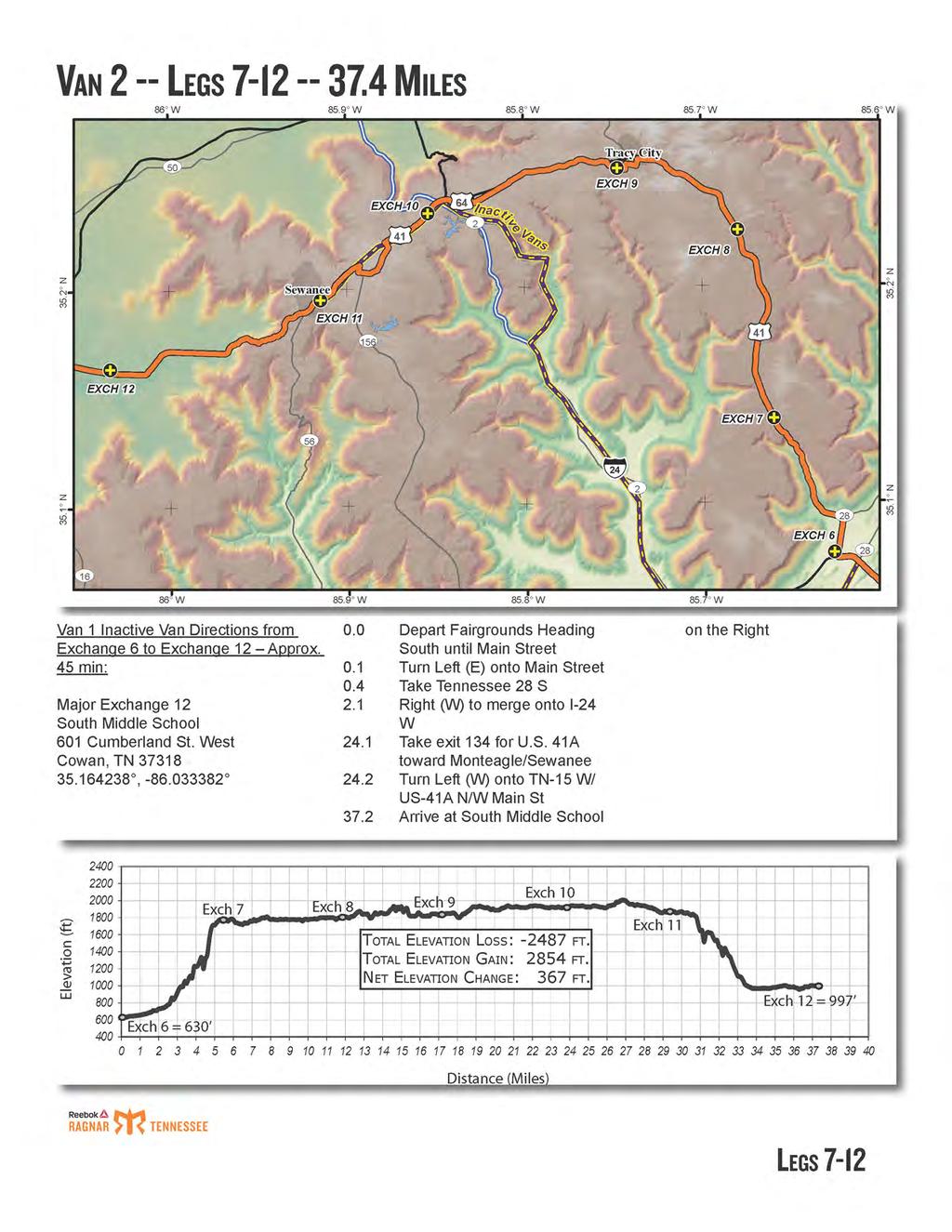
12 LEG MILES -- HARD -- NO VAN SUPPORT 85.6 w LEG MILES -- HARD Exchange 7 Abandon Mtn Mart 4381 Hwy 150 Sequatchie TN , LEG NOTES: Ragnar will provide 1 water station on this leg. In efforts to be more sustainable, this water stations will not have cups. Please carry a water bottle. Only runner 8 is allowed to cross US-41 DO NOT PARK IN RESIDENTIAL DRIVEWAYS LEG LEGEND: Depart Ex 6 heading East on W 4th St Turn Left (N) onto Betsy Pack Dr. (US-41) Merge Left (NW) onto US-41/TN-150 Arrive at Ex 7 on the left 2()(X) 18(X) 1600 :E ()(X) 8(X) t Exch 6= 630' Exch 7 = 1759' Distance (Miles) GPS CooRDS ExcH 6: , ExcH 7: , TOTAL ELEVATION Loss: -164 FT TOTAL ELEVATION GAIN: 1299 FT. NET ELEVATION CHANGE: FT ReebokA f+i RAGNAR TENNESSEE LEG 7

13 LEG MILES -- HARD -- NO VAN SUPPORT LEG MILES -- HARD Exchange 8 Ricky's Automotive Repair TN-150 Sequatchie, TN LEG NOTES: Ragnar will provide 1 water station on this leg. In efforts to be more sustainable, this water stations will not have cups. Please carry a water bottle. Drivers must remain available at Exchange 8 to allow truck driver access to parking. Only Runner 9 is allowed to cross US-41 LEG LEGEND: 0.0 Depart Ex 7 heading North on US-41/ TN-1 SO 6.5 Arrive at Ex 8 on the right..,, :ii 0.+J GPS CooRos 1!1:!!!!!!!!!!""-IExcH 7: , EXCH 8: , TOTAL ELEVATION Loss: -217 FT. TOTAL ELEVATION GAIN: NET ELEVATION CHANGE: Exch 7 = 1759' "! , Exch f 8 = 1811' t t t 269 FT. 52 FT Distance (Miles) ReebokA RAGNAR TENNESSEE LEG8
14
15
16
17
18

19 LEG MILES -- MODERATE-- NO VAN SUPPORT 86.1 w 86.o s w 86.0 w LEG MILES - MODERATE Exchange S College St Winchester, TN , Leg Notes: Ragnar will provide 1 water station on this leg. In efforts to be more sustainable, this water stations will not have cups. Please carry a water bottle. LEG LEGEND: 0.0 Depart Ex 12 heading West on SR-41 ftn Arrive at Ex 13 on the left i:u (X) Exch 12 = 997' r : t_,,_.....,.- Exch-13-= 981' GPS CooRos ExcH 12: , ExcH 13: , TOTAL ELEVATION Loss: -226 FT. TOTAL ELEVATION GAIN: 210 FT. NET ELEVATION CHANGE: -16 FT. 6(X) Distance (Miles) ReebokA,._._. RAGNAR TENNESSEE LEG 13
20

21
22
23

24
25

26 LEG MILES -- HARD -- NO VAN SUPPORT 86.2 s w 86.2 w 86.2 s w LEG MILES -- HARD Exchange 19 Intersection of Ledford Mills Rd and Brinkley Rd, Wartrace, TN ' Leg Notes: Ragnar will provide 1 water station on this leg. In efforts to be more sustainable, this water stations will not have cups. Please carry a water bottle. LEG LEGEND: o.o Depart Ex 18 on trail towards bridge 500 ft. Turn Left (N) on N Jackson St 3.6 Turn Left (W) onto Motlow College Rd 5.4 Turn Left (SW) on Ledford Mills Rd 5.8 Turn Right (NW) on Brinkley Rd 5.9 Arrive at Ex (X) 1600 :E ::; LU L i (X) 600 GPS CooRos TOTAL ELEVATION Loss: -135 FT. ExcH 18: , TOTAL ELEVATION GAIN: 223 FT. ExcH 19: , NET ELEVATION CHANGE: 89 FT. Exch 19 = 1119 Exch 18= 1030' 4(X) Distance (Miles) ReebokA f+i RAGNAR TENNESSEE LEG 19

 on John Brinkley Rd Turn Left (S) on Thompson Creek Rd Turn Right (NW) on Hwy-130E Arrive at Ex 20 on right 18(X) 1600 1400 1200.")
27 LEG MILES -- VERY HARD -- PARTIAL NO VAN SUPPORT 86.37s 0 w 86.3s 0 w 86.3 W LEG MILES - VE RY HARD Exchange 20 Singleton United Methodist Church 2695 TN-130 Petersburg, TN , LEG NOTES: Teams may ONLY support their runners for the first 2 miles on Brinkley Rd and after the first mile on TN-130 Ragnar will provide 1 water station on this leg. In efforts to be more sustainable, this water stations will not have cups. Please carry a water bottle LEG LEGEND: Depart Ex 19 heading NW on Brinkley Rd Turn Left (W) on John Brinkley Rd Turn Left (S) on Thompson Creek Rd Turn Right (NW) on Hwy-130E Arrive at Ex 20 on right 18(X) J 1()(JJ 8(X) (X) GPS Coo R o s ---:" heh 20 =-797' ExCH 19: , ExcH 20: , TOTAL ELEVATION L o ss: -807 FT. TOTAL ELEVATION GAIN: 486 FT. NET ELEVATION CHANGE: -322 FT. 4(X) Distance (Miles) ReebokAf+I RAGNAR I TENNESSEE LEG20

28
29
30
31

32
33
 t- z + + :ii LEG LEGEND: 0.")
.")

 1600 1400 1200 1000 8(X) 600 Exch 25 = 758' GPS (OORDS ExCH 25: 35.669, -86.602 ExCH 26: 35.741, -86.")
34 LEG MILES -- HARD -- NO VAN SUPPORT 86.6 s w 86. w LEG MILES -- HARD Exchange 26 Eagleville City Hall 108 S Main St Eagleville, TN , z (') t- z + + :ii LEG LEGEND: 0.0 Depart Ex 25 by heading east on Baptist Church Rd 0.3 Left onto US-41 A 6.1 Arrive at Ex 26 on the right z. :ii t. z Van Directions: Van parking is located on the right of US-41 A (west side). Additional parking is located on both sides of the road past the light at US-41A and Allisona Rd. DO NOT TRY TO PARK IN THE CITY HALL PARKING LOT - RUNNER TRAFFIC ONLY LEG NOTES: Ragnar will provide 1 water station on this leg. In efforts to be more sustainable, this water station will not have cups. PLEASE carry your own water bottle. z -j,- (!) :ii I + z (!) :ii 86.6 w I s w ;::; (X) (X) 600 Exch 25 = 758' GPS (OORDS ExCH 25: , ExCH 26: , TOTAL ELEVATION Loss: -299 FT. TOTAL ELEVATION GAIN: 305 FT. NET ELEVATION CHANGE: 7 FT. Exch 26 = 764' Distance (Miles) ReebokA RAGNAR TENNESSEE LEG 26
35
36
37
38
39
40
41
42
43
44
 If you would like closer parking, expect to pay to park")
45 LEG MILES-- VERY HARD -- FULL VAN SUPPORT LEG MILES VERY HARD Exchange 36 Music City Walk of Fame Park 4th Ave S Nashville, TN , LEG NOTES: There will be FREE parking provided at the South R Lot of the Nissan Stadium (Address is: 478 S 1st St, Nashville, TN 37213) If you would like closer parking, expect to pay to park in downtown Nashville. There are several lots around Walk of Fame Park. Visit for references to nearby parking. There will be a Nashville Predators game on Saturday night, so parking will be "event pricing" LEG NOTES: Ragnar will provide 1 water station on this leg. In efforts to be more sustainable, this water station will not have cups. PLEASE carry your own water bottle. LEG LEGEND: 0.0 Depart Ex 35 heading East on Hobbs Rd 900 ft Turn Left (N) onto Valwood Dr 0.65 Turn Right (E) onto Abbot Martin Rd 1.1 Turn Left (N) onto Cross Creek Rd 1.2 Turn Right (N) to stay on Cross Creek Rd 1.4 Left 0fl/') onto Valley Brook Rd 1.9 Left 0fl/') onto Woodmont Blvd 2.1 Right (N) onto Bowling Ave 3.3 Right (E) onto sidewalk in front of West End Middle School 3.45 Straight to continue onto Richardson Ave 3.7 Left onto trail just before Chesterfield Ave 4.0 Trail will turn right to run alongside West End Ave with traffic 5.5 Left onto sidewalk along 20th Ave S 6.0 Right onto sidewalk along Charlotte Ave 7.4 Right onto sidewalk along 4th Ave N 7.5 Left onto sidewalk along Union St. (run with traffic) 7.54 Right to run down Printer's Alley 7.75 Use crosswalk to run with traffic on Commerce St 7.78 Right onto 3rd Ave N 8.0 Left onto Symphony Place 8.1 Arrive At Finish Line! Congratulations! uj (X) 6(X) 400 Exch 35 = 564' Distance (Miles) GPS CooRos ExcH 35: , FINISH: , TOTAL ELEVATION Loss: TOTAL ELEVATION GAIN: -637 FT. 495 FT. NET ELEVATION CHANGE: -141 FT. Finish= 423' ReebokA RAGNAR TENNESSEE LEG36
DAFFODIL FESTIVAL 2018 STREET PARADE BANDS & LARGE MARCHING UNITS USING BUSES (SU#5)
") DAFFODIL FESTIVAL 2018 STREET PARADE BANDS & LARGE MARCHING UNITS USING BUSES (SU#5) The Parade will start at: 10:15 a.m. in Tacoma 2:30 p.m. in Sumner 12:45 p.m. in Puyallup 5:00 p.m. in Orting MARCHERS:
DAFFODIL FESTIVAL 2018 STREET PARADE BANDS & LARGE MARCHING UNITS USING BUSES (SU#5) The Parade will start at: 10:15 a.m. in Tacoma 2:30 p.m. in Sumner 12:45 p.m. in Puyallup 5:00 p.m. in Orting MARCHERS:
RACE BOOK. PARTICIPANT S GUIDE TO THE RACE WEEKEND
 RACE BOOK A P R I L 7, 2 0 1 8 H A L F 5 K R E L AY PARTICIPANT S GUIDE TO THE RACE WEEKEND www.runbentonville.com TABLE OF CONTENTS 3 4 5 6 7 8 9 10 11 12 13 14 SCHEDULE OF EVENTS RACE RULES & TIME LIMIT
Palmetto200 Relay - Leg #1
 Palmetto200 Relay - Leg #1 Distance: 6.76 Miles Start: Red Bank Arena Rating: Hard Finish: Bethany Lutheran Church GPS Coordinates for Finish: Lat: 33.878 Long: -81.219 Finish Address: 720 Bethany Church
LOW-TECH MAPS AND SUNDRY ITEMS. LOVE THE PLANET, RECYCLE ME!
 LOW-TECH MAPS AND SUNDRY ITEMS. LOVE THE PLANET, RECYCLE ME! Ragnar Del Sol Sweet Happenings! Pre-Race Dinner Chaparral Homemade Ice Cream 472 E. Wickenburg Way, Wickenburg, AZ 85390 Thursday, February
Des Moines Women s Half Marathon Team Relay Athlete Packet
 Des Moines Women s Half Marathon Team Relay Athlete Packet Hello Beautiful, Des Moines Women s Half Marathon, 5K and Team Relay May 7th, 2017 Before we jump in to the details of our team relay, we want
USBR 21 KNOXVILLE TO CHATTANOOGA ROUTE MILE TURNS ROADS
 USBR 21 KNOXVILLE TO CHATTANOOGA ROUTE MILE TURNS ROADS 0.0 L SS Hill Rd 0.3 L SL S Gay Street 0.6 R SL E Blount Ave - stay S at SL 2.2 L SL Maryville Pike 2.3 R SS Martin Mill Pike 4.0 L Neubert Springs
 NO PARKING ZONE, YELLOW CURB (OPTIONAL) Z 8 20 MIN. 8 Z (SEE SHEET 2) 4" WHITE "X" (TYP.),(OPTIONAL) TYPE I NO PARKING ZONE, YELLOW CURB (OPTIONAL) Z 8 20 20 ALL SPACES 22 MIN., 26 MAX. EACH Z TYPE II
Welcome to the Sellwood Bridge Project Open House!
 Welcome to the Sellwood Bridge Project Open House! 5:30 7:30 pm Please sign in here Information stations and project staff are located throughout the room. Goals for Tonight s Meeting: Learn how the Preferred
2017 Relay Team Handbook
 2017 Relay Team Handbook Race Date: April 23, 2017 (Updated 4/05/17) PRESENTED BY Welcome to the Mt. Si Relay 2017 This booklet contains important information for the 34th Annual Mt. Si Relay, April 23,
Blue Mountain 200K November 10, 2018 Time Limit 13:30 hours
 Blue Mountain 200K November 10, 2018 Time Limit 13:30 hours Andrew's Cell phone: (717) 203-1471 Bill Olsen's Cell phone: (908) 268-9690 L=Left, R=Right, T=T Intersection, B=Bear, X=Cross TRO=To remain
Water Gap 300K April 14, 2018 Time Limit 20:00 hours
 Water Gap 300K April 14, 2018 Time Limit 20:00 hours Andrew's Cell phone: 717-203-1471 L=Left, R=Right, T=T Intersection, B=Bear, X=Cross TRO=To remain on, ***=Easy to miss SS=Stop Sign, TFL=Traffic Light,
USBR 21 KENTUCKY TO GEORGIA ROUTE MILE TURNS ROADS
 USBR 21 KENTUCKY TO GEORGIA ROUTE MILE TURNS ROADS 0.0 KY State Line -at Jellico, TN 0.2 R TN-297 W/Main Street stores 18.6 L TN-63 wide shoulders 20.0 R Old TN-63/E - Royal Blue Rd 28.7 S continue on
VIEW OF NISSAN STADIUM FROM THE 14TH FLOOR
 BUILDING FEATURES Prominent Downtown location Recently renovated common areas in 2016 Great views of Nashville skyline, Cumberland River and Nissan Stadium Nashville City Club recently renovated First
Course Maps Preliminary Version Awaiting final confirmation of construction on Rt. 100 June 19 Version
 Course Maps 2018 Preliminary Version Awaiting final confirmation of construction on Rt. 100 June 19 Version LEG #1- TRAIL MAP DESCRIPTION The runner lucky enough to start the race for their team immediately
Areas for Redevelopment or New Development:
 Small Group Exercise Summary Areas for Redevelopment or New Development: 1. Downtown a. Job Resource Center b. Community Activities / Activities to draw youth & millennials c. Need for additional parking
City of Davis East Covell Corridor Plan
 Community Open House #2 January 22, 2014 6:00 8:00 p.m. Veterans Memorial Center, Club Room City of Davis Introduction The (ECCP) is a taking a comprehensive look at the existing transportation systems
2019 TIR Written Directions
 Prologue (1.15 miles) Follow the flags from the Memorial Museum, around the historic Gonzales courthouse, and back! (Prologue - Leg 3) Leg 2 (5.15 miles) Immediate Right on Hwy 90A. Run on left hand shoulder
Replace Bridge 51 on Blackiston Mill Dr. over Silver Creek,
 INDIANA PROJECTS 1558 Bridge 51 1601823 1601971 I 64 Blackiston Mill Road Phase II Charlestown Rd. Clark State Forest Road Maintenance E. Main Street Improvements to Blackiston Mill Road from just north
STAGE #3 TRANSITION 1 at Camp Keystone
 STAGE #3 SWIM STAGE #3 TRANSITION 1 at Camp Keystone Mount bike AFTER bump T1 Changing Tent STAGE #3 Camp Keystone to Marineland 68 MILE BIKE STAGE #3 68 MILE BIKE Mile 0-10 SAG 0.0 Turn RIGHT out of T1.
DOWNTOWN TENINO. Goal: Get more People in Downtown. A Pamphlet of Concepts for
 A Pamphlet of Concepts for DOWNTOWN TENINO The Tenino Planning Commission believes that the highest potential for economic development and business development in the City of Tenino (in the short-term)
Traffic Signs and Signals
 CHAPTER FOUR Traffic Signs and Signals Traffic signs control traffic flow, making streets and highways safer for drivers, bicyclists and pedestrians. These signs, which are posted by the Indiana Department
Exhibit C 2018 Wasatch Back Ragnar Relay Analysis
 Event Description The 2018 Wasatch Back Ragnar Relay is a 200 mile race, run by teams of 12 runners that starts in Logan, Utah and finishes in Kamas, Utah, June 1-2, 2018. The Wasatch Back Ragnar Relay
Mileage One-Way (Remember, river left is the left side of the river headed downstream.)
") Santa Fe River Fact Sheet www.5-staryakpak.org Mileage One-Way (Remember, river left is the left side of the river headed downstream.) Mileage Chart 0.0 Santa Fe Rise (N29.87388 W82.59158) 2.4 Darby Spring,
Santa Fe River Fact Sheet www.5-staryakpak.org Mileage One-Way (Remember, river left is the left side of the river headed downstream.) Mileage Chart 0.0 Santa Fe Rise (N29.87388 W82.59158) 2.4 Darby Spring,
2019 Snowflakes and Stitches Shop Hop Driving Directions
 All shops are listed in the same order as on the Passport. While there are many different routes you could take - we have mapped out what seems to be the most direct route to each shop and between shops.
2017 Temple to Temple Relay Race Bible
 Brigham Young University-Idaho Student Activities 2017 Temple to Temple Relay Race Bible (As of May 25, 2017) The Temple to Temple Relay is a team running event that starts at the church immediately west
2018 Greenway Challenge. Up River Course Maps and Cue Sheets
 2018 Greenway Challenge Up River Course Maps and Cue Sheets Segment 1 2 laps with in- water mass start for 2.7 mile Open Water Paddle (2x 1.35 mile loop) on Olney Pond at Lincoln Woods State Park, Lincoln,
Complete Streets Funding Program Project Prioritization Plan
 Funding Program Project Prioritization Plan Location and Type Needs South Street Crosswalk Installation Stripe a new formalized crosswalk across South Street at the Anne T. Dunphy School pedestrian path
Golden Gate Park. Project Goal and Description. Lower Great Highway Facts
 PROJECT OVERVIEW Project Goal and Description The goal of the is to increase pedestrian safety and comfort along Lower Great Highway by evaluating and implementing near- and medium-term pedestrian improvements
CITY OF DELRAY BEACH. Overview Map. Commuter Mode of Choice QUICK FACTS. 47 Median Age. 65,804 Residents. 29.1% Traditionally Underserved
 CITY OF $51,829 Median Income 291% Traditionally Underserved 438% Growth from 2010 859% HS/GED 345% Bachelors 27,041 Households 620% Labor Force Lake Okeechobee Delray Beach Palm Beach County Commuter
City of Sammamish. Welcome. Issaquah-Fall City Road Improvements Project Phase I Design: 242nd Avenue SE to Klahanie Drive SE
 Welcome Welcome to the third community meeting for the Issaquah-Fall City Road Improvements Project. AGENDA 6:00 p.m. Welcome and sign-in 6:10 p.m. Presentation 6:50 p.m. Open house Learn about the roadway
Chapter 3.6 Elementary School Z. Volusia County MPO. March Page 13.0
 Chapter 3.6 Elementary School Z DeLand, FL Volusia County MPO March 2008 Page 13.0 Volusia County MPO Bicycle and Pedestrian School Safety Review Study Introduction Elementary School Z is a planned elementary
Technical Guide. Windrock ProGRT March 8 th to 12 th 2017 Oliver Springs, TN USA Windrockbikepark.com
 Technical Guide Windrock ProGRT March 8 th to 12 th 2017 Oliver Springs, TN USA Windrockbikepark.com Welcome Overview Windrock Park is one of the United States longest running off-road parks a premiere
Leg #1 (GUNLOCK AND LOADED) Miles
 Miles") Leg #1 (GUNLOCK AND LOADED)- 6.07 Miles Difficulty: Easy to Moderate This is a nice leg for those who like running downhill. It s a beautiful run down the Santa Clara River canyon to the point where the
Leg #1 (GUNLOCK AND LOADED)- 6.07 Miles Difficulty: Easy to Moderate This is a nice leg for those who like running downhill. It s a beautiful run down the Santa Clara River canyon to the point where the
DIRECTIONS TO SCHOOLS From Florence Christian
 DIRECTIONS TO SCHOOLS From Florence Christian AUGUSTA CHRISTIAN Take I-20 West to Washington Road Exit. Turn right onto Washington Road, proceed on Washington Road and turn right onto Furys Ferry at red
TRAFFIC MANAGEMENT PLAN
 292 84 140440 TRAFFIC MANAGEMENT PLAN The purpose of the Traffic Management Plan (TMP) is to have established procedures for traffic flow and circulation around the elementary school related to student
CAPITOL DRIVE & FOND DU LAC AVENUE INTERSECTION ANALYSIS. Urban Planning 772 SARAH BREGANT, RYAN PETERSON, & MATT WERDERITCH
 CAPITOL DRIVE & FOND DU LAC AVENUE INTERSECTION ANALYSIS Urban Planning 772 SARAH BREGANT, RYAN PETERSON, & MATT WERDERITCH OVERVIEW N 51 ST BOULEVARD N 51 ST BOULEVARD 12,100 44,700 W CAPITOL DRIVE 52,600
BOARD OF COUNTY COMMISSIONERS AGENDA ITEM SUMMARY
 7B BOARD OF COUNTY COMMISSIONERS AGENDA ITEM SUMMARY PLACEMENT: REQUESTS AND PRESENTATIONS PRESET: TITLE: FLORIDA DEPARTMENT OF TRANSPORTATION (FDOT) PRESENTATION RECONSTRUCTION OF SR-76 (SW KANNER HIGHWAY)
Lee County Department of Transportation 1500 Monroe Street Fort Myers, FL (239) (239) Fax
 (239) Fax") Lee County Department of Transportation 1500 Monroe Street Fort Myers, FL 33901 (239) 533-8580 (239) 485-8520 Fax ROAD WATCH UPDATE October 12 October 18, 2017 Gunnery Road and 8th Street SW Intersection
Lee County Department of Transportation 1500 Monroe Street Fort Myers, FL 33901 (239) 533-8580 (239) 485-8520 Fax ROAD WATCH UPDATE October 12 October 18, 2017 Gunnery Road and 8th Street SW Intersection
Implementation challenge 2: Is there room for Complete Streets? Does street classification enable Complete Streets?
 Implementation challenge 2: Is there room for Complete Streets? Does street classification enable Complete Streets? 1 Do we have to widen roads to fit everything? 2 There s room; it needs to be recaptured
62.21 miles. RVCR 100K Starts In Phoenix, Oregon. 2,595ft Max 1,060ft Min +2,185ft -2,172ft 5.8 % 1 2. Page 1 of 1
 RVCR 100K Starts In Phoenix, Oregon 62.21 miles 2,595ft Max 1,060ft Min +2,185ft -2,172ft 5.8 % 1 2 Rogue Valley Challenge Relay 100K Find this route online at mapmyrun.com/ routes/ view/34000740 RVCR
DIRECTIONS ARE FROM DISNEY S WIDE WORLD OF SPORTS TM COMPLEX
 PAGE ONE Disney s Wide World of Sports Complex Milkhouse (COURTS 1-6) Jostens Center (COURTS 7-12) 700 South Victory Way Kissimmee, FL 34747 (407) 828-3267 Traveling Westbound on I-4 Take I-4 to exit 65/old
Monument Elementary School Trenton, NJ School Travel Plan
 Monument Elementary School Trenton, NJ School Travel Plan Prepared by Greater Mercer TMA With Assistance from Alan M. Voorhees Transportation Center; Rutgers, The State University of New Jersey and NJ
Downtown Dunedin Merchant Association 26th Annual Dunedin Mardi Gras Parade Bourbon Street Meets Main Street is this year s theme
 Downtown Dunedin Merchant Association 26th Annual Dunedin Mardi Gras Parade Bourbon Street Meets Main Street is this year s theme Tuesday, February 28 th 2017 PARADE APPLICATION Sponsoring Group/Business:
HALFF TRAFFIC MANAGEMENT PLAN. Richardson ISD Northwood Hills Elementary School Dallas, Texas. /? /4O/2o16
 30279 161966 TRAFFIC MANAGEMENT PLAN Richardson ISD Northwood Hills Elementary School August 30 2016 Exhibit 976B Planned Development District No. 976 Z156-311(OTH) Approved City Plan Commission October
Building Great Neighbourhoods BONNIE DOON
 Building Great Neighbourhoods BONNIE DOON We Are Here Today To Explain the Neighbourhood Renewal Process Show you the Westwood Preliminary Design Ask for local knowledge Highlight the Local Improvement
State Road (S.R.) 61 (U.S. 319) FPID s and
 61 (U.S. 319) FPID s and") State Road (S.R.) 61 (U.S. 319) FPID s 220496 2 22 01 and 219747 2 22 01 Crawfordville Highway Conceptual Design and Environmental Reevaluation May 6, 2014 END PROJECT PROJECT LOCATION/LIMITS Project Limits:
State Road (S.R.) 61 (U.S. 319) FPID s 220496 2 22 01 and 219747 2 22 01 Crawfordville Highway Conceptual Design and Environmental Reevaluation May 6, 2014 END PROJECT PROJECT LOCATION/LIMITS Project Limits:
Buckeye Mountaineer Conference Directions
 Buckeye Mountaineer Conference Directions Beaver Local: Volleyball, Basketball, Football, Track, Wrestling Beaver Local Middle School 46088 Bell School Road East Liverpool, OH 43920 Route 7 North to Route
Leg 1: 4.7 miles, Easy
 Leg 1: 4.7 miles, Easy Run Legs 1-4 on L. L - 0.0 Church bike path to Coffield Ave. L - 0.2 still Coffield Ave. R - 0.3 Solano Ave. L - 1.0 West Pueblo Ave. R - 2.4 Redwood Rd. L - 2.5 Dry Creek Rd. in
2009 AAU GIRLS BASKETBALL SUPER REGIONAL CHAMPIONSHIPS SOUTHERN PREMIER HOOPS ATLANTA, GA
 2009 AAU GIRLS BASKETBALL SUPER REGIONAL CHAMPIONSHIPS SOUTHERN PREMIER HOOPS ATLANTA, GA QUALIFY FOR NATIONALS AAU MEMBERSHIP: All participants and coaches must be members of the Amateur Athletic Union
A WORLD-CLASS, CREATIVE HUB IN THE HEART OF NASHVILLE TOWER 401 CHURCH STREET
 A WORLD-CLASS, CREATIVE HUB IN THE HEART OF NASHVILLE L&C TOWER 401 CHURCH STREET MULTI-MILLION DOLLAR, FULL BUILDING RENOVATION L & C Tower offers tenants creative office space with contiguous blocks
2016 I-30 CROSSING ARKANSAS BOULEVARD KEY IDEAS OF PLAN B:
 KEY IDEAS OF PLAN B: Transportation shall support all parts of the cities and improve the quality of life downtown. There is no need to shorten commuting time at rush hour by a few minutes at the risk
The Will To Live Foundation, Inc. For The Kids, Through The Kids, By The Kids WELCOME TO THE 2019 EDITION OF WHERE THERE S A WILL THERE S A WAY 5K
 WELCOME TO THE 2019 EDITION OF WHERE THERE S A WILL THERE S A WAY 5K (Fun Run For Hope) Directions, Parking instructions, Check In Procedure and 5K Course document! General Directions To River Trail Middle
2016 CANLAKE50 RACE HANDBOOK
 2016 CANLAKE50 RACE HANDBOOK October 8, 2016 Finger Lakes Community College 3325 Marvin Sands Dr, Canandaigua, NY 14424 TABLE OF CONTENTS Table of Contents... 2 Beneficiary Serenity House... 2 Sponsors...
LTAC: Katie Mencarini, Central & Hampton Roads streets and a fifteen minute debrief to discuss the findings. Participants walked along Mill Road
 Walkabout Summary On June 3, 2013, five participants met at Glen Allen Elementary School in Glen Allen, Virginia to take a closer look at the walking and biking network around the school. In addition to
BRR Leg 25 (4.3 miles, Moderate)
") BRR Leg 25 (4.3 miles, Moderate) Min 2290 Max 2492 Ascent +287 Descent -244 0.0 EZ 24 (Bakersville Fire Dept.) 0.0 Cross bridge 0.0 L Route 226 4.3 Red Hill Baptist Church, on L (EZ 25) Leg Notes: 226
BRR Leg 25 (4.3 miles, Moderate) Min 2290 Max 2492 Ascent +287 Descent -244 0.0 EZ 24 (Bakersville Fire Dept.) 0.0 Cross bridge 0.0 L Route 226 4.3 Red Hill Baptist Church, on L (EZ 25) Leg Notes: 226
Queensboro Bridge Bus Priority Study: Summary of Recommendations. Presentation to Manhattan Community Board 8 May 4, 2011
 : Summary of Recommendations Presentation to Manhattan Community Board 8 May 4, 2011 1 Overview Study Goal: Identify cost-effective ways to improve bus speed and reliability for local and express buses
Merrick and Memorial Neighborhood Study 5/14/2014 Public Meeting
 Merrick and Memorial Neighborhood Study 5/14/2014 Public Meeting Study Area April 9 Public Meeting Comments Summary Pedestrian Safety - A Walking Neighborhood Pedestrian traffic is very difficult A need
Driving directions during the closure of Business 40 for the Downtown Health Plaza in Innovation Quarter
 Driving directions during the closure of Business 40 for the Downtown Health Plaza in Innovation Quarter BUSINESS 40 IMPROVEMENT PROJECT AUGUST 31, 2018 DRIVING TO THE DOWNTOWN HEALTH PLAZA DURING BUSINESS
SECTION VII ROADWAY AND SITE IMPROVEMENTS
 SECTION VII ROADWAY AND SITE IMPROVEMENTS TOC-VII.1 of 4 TABLE OF CONTENTS ROADWAY AND SITE IMPROVEMENTS No. Title I-1 Alley Intersection (Commercial Areas) I-2 Valley Gutter For 90 Intersection I-3 Typical
2016 YARK Subaru 5-Person Relay Marathon
 2016 YARK Subaru 5-Person Relay Marathon www.glasscitymarathon.org 5-Person Marathon Relay The following pages contain detailed maps of each exchange point along with directions to the next exchange point.
WELCOME! Please complete a comment sheet as we value your feedback. 4 pm to 8 pm. September 15, Hosted by: AECOM on behalf of City of Calgary
 WELCOME! Thank you for attending our open house. There will be no formal presentation today so please take the time to read the boards. If you have any questions, please do not hesitate to approach one
CITY OF OAK CREEK SAFE ROUTES TO SCHOOL ACTION PLAN. East Middle School
 CITY OF OAK CREEK SAFE ROUTES TO SCHOOL ACTION PLAN East Middle School CITY OF OAK CREEK SAFE ROUTES TO SCHOOL ACTION PLAN East Middle School Why Safe Routes to School? Safe Routes to School ( SRTS ) is
Reference: Laguna Canyon Road Traffic Conditions Data Collection Summary
 Stantec Consulting Services Inc. 38 Technology Drive Suite 100, Irvine CA 92618-5312 September 8, 2017 File: 2073014320 Attention: Mark Trestik, Assistant City Engineer City of Beach Department of Public
2012 PRIORITY TRANSPORTATION PROJECTS
 0 PRIORITY TRANSPORTATION PROJECTS The 0 Priority Transportation Projects include candidate road, congestion management, multi-use trail, transit, transportation regional incentive program (TRIP), county
Comments EXECUTIVE SUMMARY
 Comments 1. Under any Alternatives, MCDOT should provide better at-grade pedestrian crossing of Georgia Avenue and Forest Glen Road, including improved crosswalks with wider medians and adequate signal
City of Gainesville Transportation/Roadway Needs PROJECT SUMMARY
 A1 Roadway Resurfacing $23,846,000 TYPE: Preservation of existing system Roadway resurfacing A2 Signal Replacement $6,000,000 TYPE: Preservation of existing system Replace traffic signals. B1 W 6th St
SAFE ROUTES TO SCHOOL
 SAFE ROUTES TO SCHOOL Edgewood Elementary School Existing Conditions and ACTION PLAN > Oak Creek - Franklin Joint School District Table of Contents CONTEXT Enrollment Boundaries Enrollment
Turnpike Projects in Palm Beach County. Palm Beach TPA Update September 20, 2018
 Turnpike Projects in Palm Beach County Palm Beach TPA Update September 20, 2018 Agenda Background Funded Projects Future Project Status Widenings Interchanges Express Lanes Phasing 2 Background 45 Miles
SOUND TRANSIT AT A GLANCE
 SOUND TRANSIT AT A GLANCE STATION ACCESS IMROVEMENTS ROJECT Sound Transit operates Sounder commuter trains, ST Express buses and Link light rail. The 2008 voter-approved Sound Transit 2 package included
TRAFFIC ACTION PLAN. Laurie Meadows Neighborhood CITY OF SAN MATEO
 TRAFFIC ACTION PLAN Laurie Meadows Neighborhood CITY OF SAN MATEO Draft January 2017 Table of Contents Introduction... 2 The Traffic Forum Process... 5 Neighborhood Traffic Issues... 7 Neighborhood Recommendations
11,000. P.M. Peak Hour Vehicles/Hour 10,000 9,000 8,000. Year
 CONGESTION RELIEF TASK FORCE The problem today With traffic levels hampering downtown circulation, and long delays in west Salem, policy makers are evaluating potential transportation infrastructure, programs,
Trail and Driving Directions
 Trail and Driving Directions GETTING TO THE START: FROM CADILLAC: Follow M-55 west from US131 for 20.9 miles to the corner of M-37 and M-55 FROM THE INTERSECTION OF M-55 AND M-37: Head west on M-55 2.7
Brookings Traffic Safety Committee 2017 Annual Report
 Brookings Traffic Safety Committee 2017 Annual Report PURPOSE The current Traffic Safety Committee was formed by Resolution 58-79 dated December 18, 1979 with its stated duties and responsibilities of
APPENDIX G: INTERSECTION NEEDS AT OKEECHOBEE BOULEVARD
 APPENDIX G: INTERSECTION NEEDS AT OKEECHOBEE BOULEVARD INTERSECTION NEEDS AT SR 7 and OKEECHOBEE BOULEVARD SR 7 Extension Project Development and Environment (PD&E) Study From Okeechobee Boulevard (SR
Welcome. 53 Avenue Overpass over Whitemud Drive Rehabilitation. Public Information Session. Wednesday, March 9, :30-8:00 p.m.
 BRIDGE REHABILITATION Welcome 53 Avenue Overpass over Whitemud Drive Rehabilitation Public Information Session Wednesday, March 9, 2016 4:30-8:00 p.m. Tonight you can: Learn about the 53 Avenue Overpass
THE OFFICIAL GUIDE TO CYCLING SAFELY IN PHILADELPHIA
 B IKE NICE THE OFFICIAL GUIDE TO CYCLING SAFELY IN PHILADELPHIA A partnership of the City of Philadelphia and the Bicycle Coalition of Greater Philadelphia ABOUT VISION ZERO & BIKE NICE It s a great day
AAA School Safety Patrol Lifesaving Nomination
 AAA School Safety Patrol Lifesaving Nomination A proud tradition since 1920, the AAA School Safety Patrol program equips patrollers with the skills and resources needed to ensure children commute to and
CLINT THAYER, FOCAL FLAME PHOTOGRAPHY SPECTATOR GUIDE SUNDAY, NOVEMBER 12, 2017 MADISONMARATHON.ORG
 SPECTATOR GUIDE SUNDAY, NOVEMBER 12, 2017 MADISONMARATHON.ORG CLINT THAYER, FOCAL FLAME PHOTOGRAPHY WELCOME TO THE MADISON MARATHON TABLE OF CONTENTS 2017 SCHEDULE 3 FAQs & EXPO 4 RACEYJOY & RUNNER TRACKING
DeSoto County. Fiscal Years FDOT Draft Tentative Five Year Work Program Project Highlights
 DeSoto County Fiscal Years 2019-2023 FDOT Draft Tentative Five Year Work Program Project Highlights DeSoto Map ID 1 Project Description SR 70 over Joshua Creek - Bridge #040027 Bridge - Repair / Rehabilitation
The Richland County Transportation Penny Program. September 21, 2015
 The Richland County Transportation Penny Program September 21, 2015 Program Funding Categories Bike / Ped./ Greenway, $80,888,356 Administration, $32,100,000 Bus Service, $300,991,000 Roadway Projects,
INTERSECTION CONTROL NOVEMBER 2018
 INTERSECTION CONTROL NOVEMBER 2018 ICE OVERVIEW AGENDA Why ICE? When ICE is Required? Applicability and Process 2 AVAILABLE RESOURCES http://www.fdot.gov/traffic/trafficservices/intersection_operations.shtm
PEDESTRIAN SAFETY, MOBILITY & CONTEXT IMPROVEMENT STUDY
 PEDESTRIAN SAFETY, MOBILITY & CONTEXT IMPROVEMENT STUDY STATE ROUTES 70/20 MARYSVILLE, CA JULY 2008 PREPARED BY LOCAL GOVERNMENT COMMISSION COMMUNITY PARTNERS LLC MIG: MOORE IACOFANO GOLTSMAN DESIGNING
LIST OF PRIORITY PROJECTS 2020/ /35
 LIST OF PRIORITY PROJECTS 2020/21-2034/35 Adopted June 10, 2015 Prepared by the Lake~Sumter Metropolitan Planning Organization 1616 South 14th Street Leesburg, FL 34748 This report was financed in part
Driver Education Ch. 4: Safe Driving Rules & Regulations. Ms. Marx
 Driver Education Ch. 4: Safe Driving Rules & Regulations Ms. Marx Speed Control Speed is one of the most common contributing factors of fatal & other types of accidents School zones, business or residential
DOT Policy and Procedure Integrity Excellence Respect
 DOT Policy and Procedure 05.05.020 Integrity Excellence Respect Alaska s Speed Limit Policy Contained in DOT Policy and Procedure (P&P) 05.05.020, Establishment of Speed Limits and Zones Incorporates pertinent
FI N A N C I A L RESOURCER S REVIEW AND UPDATE M I A M I-DADE LO N G R A N G E TRANSPORT T ATION PLAN UPDATE TO THE YE
 Appendix B: Miami-Dade LRTP Cost Feasible Projects (Fully Funded and Partially Funded Projects) Fully Funded Projects Existing County roads O&M $317.9 $316.7 $811.5 Non Motorized set aside $27.9 $24.7
AGENDA REPORT. Issue: Discussion of potential improvements on Barnwell Road at Niblick Drive
 AGENDA REPORT To: From: By: Honorable Mayor and City Council Members Warren Hutmacher, City Manager Tom Black, Public Works Director Date: March 23, 2016 Agenda: March 28, 2016 WORK SESSION AGENDA: Barnwell
GIS Based Data Collection / Network Planning On a City Scale. Healthy Communities Active Transportation Workshop, Cleveland, Ohio May 10, 2011
 The Purpose of GIS Based Network Planning GIS Based Data Collection / Network Planning Healthy Communities Active Transportation Conference Tuesday, May 10, 2011 10:00 AM Norman Cox, LLA, ASLA. Ann Arbor,
Welcome 78 Ave S.E. Underpass and Road Widening Project Update
 Welcome 78 Ave S.E. Underpass and Road Widening Project Update About the 78 Avenue S.E. Project 69 Avenue S.E. crossing of CP proposed to close to accommodate future CP operations. 78 Avenue S.E. would
Cumberland River Flood Preparedness Mapping and Products
 Cumberland River Flood Preparedness Mapping and Products Barry P. Moran, P.E. Hydraulic Engineer Nashville District September 2013 US Army Corps of Engineers BUILDING STRONG Authority: As a result of the
including shade trees; Recommend minimum 13 ft total sidewalk
 Appendix B Projects From Other Plans Location Type of Project Description West. Julian St. Intersection and streetscape along West Julian St. Intersection and scape : Add high visibility side street crosswalks
Recommendations. Central Salem Mobility Study
 Central Salem Mobility Study The Central Salem Mobility Study evaluated a range of multimodal transportation issues affecting downtown Salem, including circulation, access, and safety for people traveling
CLINT THAYER, FOCAL FLAME PHOTOGRAPHY SPECTATOR GUIDE SUNDAY, NOVEMBER 11, 2018 MADISONMARATHON.ORG
 SPECTATOR GUIDE SUNDAY, NOVEMBER 11, 2018 MADISONMARATHON.ORG CLINT THAYER, FOCAL FLAME PHOTOGRAPHY WELCOME TO THE MADISON MARATHON TABLE OF CONTENTS 2018 SCHEDULE 3 FAQs & EXPO 4 RACEYJOY & RUNNER TRACKING
TRAFFIC CALMING TOOLBOX
 TRAFFIC CALMING TOOLBOX Traffic control devices are those official signs and striping placed in the public right-of-way and recognized by the public such as STOP signs, curve warning signs, centerline
U.S. HIGHWAY 50 IMPROVEMENT PROJECT
 U.S. HIGHWAY 50 IMPROVEMENT PROJECT in the City of South Lake Tahoe Project Purpose and Need Planned Improvements Project Cost and Delivery Schedule Proposed Construction Staging Project Partners: HIGHWAY
Lee County Department of Transportation 1500 Monroe Street Fort Myers, FL (239) (239) Fax
 (239) Fax") Lee County Department of Transportation 1500 Monroe Street Fort Myers, FL 33901 (239) 533-8580 (239) 485-8520 Fax ROAD WATCH UPDATE August 24 August 30, 2017 Hancock Bridge Parkway: Lee County DOT will
Lee County Department of Transportation 1500 Monroe Street Fort Myers, FL 33901 (239) 533-8580 (239) 485-8520 Fax ROAD WATCH UPDATE August 24 August 30, 2017 Hancock Bridge Parkway: Lee County DOT will
Controlled. Semi-Controlled PAGE 01 CHAPTER 12 INTERSECTIONS
 PAGE 01 CHAPTER 12 INTERSECTIONS You will cross many intersections while driving. Intersections are especially dangerous because vehicles are crossing each other s driving path. Many crashes happen at
City of Wilsonville 5 th Street to Kinsman Road Extension Project
 City of Wilsonville 5 th Street to Kinsman Road Walking Tour & Neighborhood Workshop Summary Report Public Outreach Overview On July 18 th, 2017, the City of Wilsonville hosted a neighborhood walking tour
April 23, 2017 Mercy Health Glass City Marathon Yark Subaru 5-Person Relay Marathon
 April 23, 2017 Mercy Health Glass City Marathon Yark Subaru 5-Person Relay Marathon 5-PERSON RELAY MARATHON The following pages contain detailed maps of each exchange point along with directions to the
May 10, 2013 Meredith Cruz, (561) Palm Beach County Traffic Report May 10 through May 17, 2013
 Palm Beach County Traffic Report May 10 through May 17, 2013") May 10, 2013 Meredith Cruz, (561) 641-6440 mcruz@corradino.com Palm Beach County Traffic Report May 10 through May 17, 2013 Palm Beach County Palm Beach County traffic will be affected this week by ongoing
May 10, 2013 Meredith Cruz, (561) 641-6440 mcruz@corradino.com Palm Beach County Traffic Report May 10 through May 17, 2013 Palm Beach County Palm Beach County traffic will be affected this week by ongoing