Ryuichiro Nishi, Li Erikson and MyoKhin Kagoshima Univ., Lund Univ., Daiichi Institute of Technology
|
|
|
- Ethan Richard
- 5 years ago
- Views:
Transcription


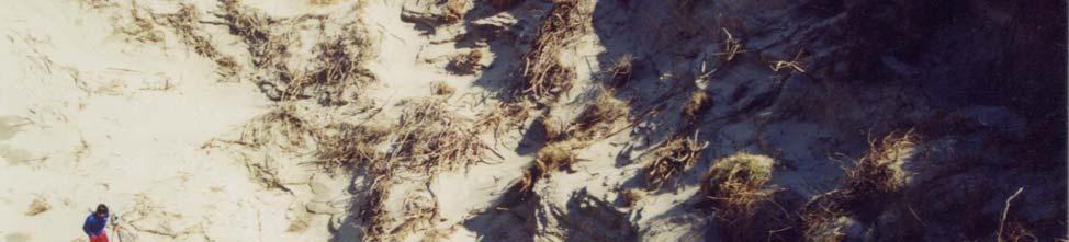
1 Dune blowout hollow generated in Fukiage Dune, Kagoshima, Japan Ryuichiro Nishi, Li Erikson and MyoKhin Kagoshima Univ., Lund Univ., Daiichi Institute of Technology

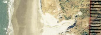
2 Contents of this presentation; topography change of frontal dune No.1


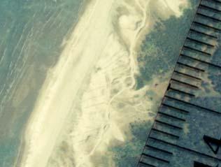
3 Topography change of frontal dune No. 2 Dune scarp
4 Processes of Dune topography changes 1. Sand dune stabilized by vegetation and coastal forest 2. Dune scarp generation caused by storm surge and high waves 3. Wind blowout hollow generation and expansion, and destruction of vegetation surface 4. Breaching of wind blowout hollow and destruction of frontal dune 5. (Normal) Enhanced wind blown sand process Dune protect human beings and property against high waves, storm surge and tsunami! It should be properly stabilized!

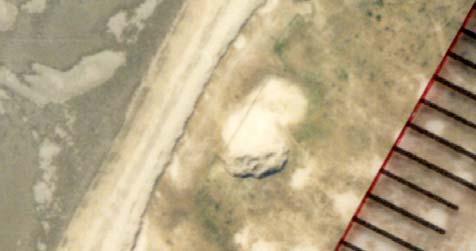
5 Example of cross-shore profile of dune blowout hollow

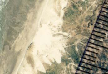
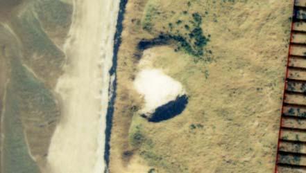
6 Example; 3D topography of wind blowout hollow Unit (m)

7 Example 2; 3D topography of wind blown sand area Topography after a breaching of wind blowout hollow
8 Previous study on a dune Dune erosion -----Erosion due to storm surge and high waves Dune erosion ---- Dune scarp generation Wind blown sand ---- Annual and seasonal wind blown sand rate Stabilization of dune ----Vegetation, coastal forest and fence Topography change due to wind vortex (turbulence)
9 Overview of wind blown hollow *Growth of coastal forest Saburo Akagi (1991) Yoshiro Hatakeyama(1998) *Dune (wind blown sand) stabilization CERC(1984) : Shore protection manual *Character of wind blown sand Carter (1993) Nordstrom et al. (1990)
 Tokyo")
10 Study area (Fukiage dune, Kagoshima, Japan) Tokyo Kagoshima
11 Study area (Fukiage dune, Kagoshima, Japan) Kagoshima Dominant wind direction in winter Kagoshima Pref.; 2700km coastal line 600km long Manose R. Isaku R. Okinawa
12 Aerial photographs used for analysis Predominant wind in winter No. 1 Right hand side of Manose River (Down stream side) No. 2 Intermediate region No. 3 Left hand side of Isaku River (Up-stream side) Original aerial photo 1/10,000 Enlarged to 1/5,000 for analysis
13 Example of aerial photographs used for analysis Predominant wind in winter Predominant wind in winter

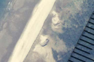
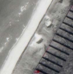
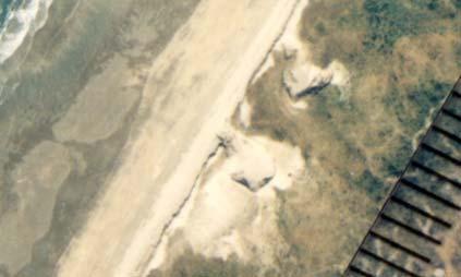
14 Position and geometry of wind blowout hollow Sea Sandy beach Dune field L 2 D 1 L 1 D 1 ; Cross-shore distance L 1 ; Cross-shore radius L 2 ; Longshore radius Dune scarp Wind blowout hollow
15 Cross-shore distance of wind blowout hollow; D 1 L 1 Cross-shore distance from the edge of dune scarp (m)
16 80 70 Spatial distribution of wind blowout hollow 風食孔の岸沖距離 (m) Cross-shore distance; D 1 (m) 浜崖頂部から風食孔までの距離 (m) Longshore 沿岸距離 distance ( m) (m)
17 Frequency diagram; landward distance of a hollow center from an edge of dune scarp 10 風食孔発生位置の頻度分布 頻度 ( 個所 ) Frequency Data: Data13_Count Model: Gauss Chi^2 = y ± xc ± w ± A ± Gaussian distribution ガウス分布フィット Cross-shore 浜崖頂部から distance from の内陸側距離 the edge of (m) dune scarp (m)
18 46 wind blown hollow in 6.3km coastal stretch 1 in every 137m Most of the hollow features are created in an area between 10 to 40 m from the edge of dune
 短軸長さ ( m) 区間 : 万ノ瀬川 ~ 伊作川 0 1000 2000 3000 4000 5000 6000 沿岸距離 ( m) Longshore distance")
19 Geometry of dune blowout hollow 160 Cross-shore radius & longshore radius (m) 風食孔長軸 短軸長さ ( m) 長軸長さ ( m) 短軸長さ ( m) 区間 : 万ノ瀬川 ~ 伊作川 沿岸距離 ( m) Longshore distance (m)
20 Average length of cross-shore radius = 40m Average length of longshore radius = 29m
21 Cross-shore 風食孔短軸長さ radius (m) ( m) Geometry of dune blowout hollow 風食孔の形状 ( 長軸長さと短軸長さの比較 ) Expansion of single blowout hollow Breaching Combination of neighboring blowout hollows Longshore 風食 radius 孔長 (m) 軸長さ ( m)
22 Geometry of blowout hollow; expansion stage y = 0.64x R = 0.84, SD = 5.81 Cross-shore 短軸長さ radius ( m) (m) Longshore radius 長軸長さ (m) (m)
23 D 1 ; Cross-shore distance L 1 ; Cross-shore quasi-radius L 2 ; Longshore quasi-radius Sandy beach Wind blown sand dominated area Dune field Sea L 2 D 1 L 1 (Breached) dune scarp
24 Stage III (Normal wind blown sand); Position of wind blown sand area 100 飛砂領域の岸沖距離 ( m) Cross-shore distance; D 1 (m) 岸沖方向距離 ( m) 沿岸距離 ( m) Longshore distance (m)
25 Geometry of wind blown sand dominated area L 1 & L 2 Cross-shore radius & longshore radius (m) 長軸 短軸長さ ( m) 長軸長さ ( 飛砂の卓越方向 ) 短軸長さ ( 沿岸方向 ) Longshore 沿岸 distance 距離 ( m) (m)
26 Average length of cross-shore radius = 78m Average length of longshore radius = 60m
27 Geometry of wind blown sand area; stage III 250 Cross-shore 短軸長さ radius ( m) (m) 飛砂発生域の長軸 短軸長さ Y=1.24X Longshore radius 長軸長さ (m) ( m)
 m) 300 200 100 0 0 5 10 15 20 25 30 35 40 45 50 Identification number 発生個所")
28 Distance between neighboring wind blown sand areas & wind blowout hollows 風食 飛砂領域の発生間隔 ( m) 400 Distance 発生間隔 ( (m) m) Identification number 発生個所 No.
29 Frequency distribution of distance between wind blown sand areas & blowout hollows Frequency (No.) 頻度 ( 個所 ) 風食孔 飛砂領域の発生間隔頻度 Data: Data11_Count Model: Gauss Chi^2 = y ± xc ± w ± A ± Gaussian ガウス分布フィ distribution ット Distance (m) 発生間隔 ( m)


30 Average annual deposition rate per unit shoreline length & total wind blown sand rate Total wind blown sand transport rate in the study area is nearly 20,000 to 30,000 m 3 /year Annual deposition of wind blown sand is nearly 20cm Summer season Winter season
31 Wind observation Wind speed (m/s)

32 Wind numerical simulation Example of numerical result; wind velocity field
33 Major conclusions; 1. Geometry size of wind blowout hollows and wind blown sand areas is wider in upstream region of predominant wind (Isaku region) than down-stream region (Manose region), in general. 2. Wind blowout hollows are generated in the narrow band area which exists 10m to 50m landward from the edge of frontal dune scarp.
34 Major conclusions; 3. Wind blowout hollow develop it s size as much as 50m long, then a seaward boundary reaches to the edge of frontal dune scarp face to breach the frontal dune completely. 4. Average distance between the wind blowout hollows and wind blown sand areas is 113.4m in the study site.


35 Major conclusions; 5. Nearly vertical slope of dune scarp caused by storm surge and high waves enhances a wind turbulence behind the frontal dune, and causes wind blowout hollow and destruction of vegetation covering dune surface. 6.After the breaching of frontal dune, landward wind causes more wind blown sand than stabilized dune by vegetation.
36 Ready for submission;


37 Time for Q&A Thank you very much for your kind attention!
 Cross-shore")
38 Plan view of dune blowout Longshore distance (m) Cross-shore distance(m)
39 Dune profile without wind blowout hollow Isaku, Fukigae 10 8 E 6 l e v 4 a t i o 2 n (m) Distance offshore(m)


40 Wind blowout hollow which is cut at seaside edge


41 Spreading out of wind blown sand


42 Turbulence created behind an edge of frontal dune Snapshot behind an edge of frontal dune
Wind Blow-out Hollow Generated in Fukiage Dune Field, Kagoshima Prefecture, Japan
 R. Nishi Wind Blow-out Hollow Generated in Fukiage Dune Field, Kagoshima Prefecture, Japan Ryuichiro Nishi, Li Elikson and Myokhin PREFACE A sand dune is vulnerable to severe waves and wind. Therefore,
BEACH CHANGES CAUSED BY EXTENSION OF OFFSHORE BREAKWATER AND LIMITATIONS OF ARTIFICIAL REEFS CONSTRUCTED AS A MEASURE AGAINST BEACH EROSION
 BEACH CHANGES CAUSED BY EXTENSION OF OFFSHORE BREAKWATER AND LIMITATIONS OF ARTIFICIAL REEFS CONSTRUCTED AS A MEASURE AGAINST BEACH EROSION Yasuhito Noshi 1, Takaaki Uda and Yukiyoshi Hoshigami 3 Beach
DISAPPEARANCE OF SANDY BEACH TRIGGERED BY EXTENSION OF FISHING PORT BREAKWATER AND EXCESS LAND RECLAMATION
 Proceedings of the 7 th International Conference on Asian and Pacific Coasts (APAC 2013) Bali, Indonesia, September 24-26, 2013 DISAPPEARANCE OF SANDY BEACH TRIGGERED BY EXTENSION OF FISHING PORT BREAKWATER
EROSION MECHANICS OF A CARBONATE- TOMBOLO BEACH IN MIYAKOJIMA ISLAND, OKINAWA PREFECTURE, JAPAN.
 EROSION MECHANICS OF A CARBONATE- TOMBOLO BEACH IN MIYAKOJIMA ISLAND, OKINAWA PREFECTURE, JAPAN. Ryuichiro NISHI 1, Takaaki UDA 2, Akio KIKUCHI 3 and Kou FURUIKE 4 1) Associate Prof. Dept. of Ocean Civil
FIELD EXPERIMENT ON BEACH NOURISHMENT USING GRAVEL AT JINKOJI COAST
 FILD XPRIMNT ON BACH NOURISHMNT USING GRAVL AT JINKOJI COAST Takayuki Kumada, Takaaki Uda, Takeo Matsu-ura and Michio Sumiya Beach nourishment using 87, m of gravel with grain size between.5 and mm was
Mechanisms and Characteristics of High-Speed Reef Rip Current
 Mechanisms and Characteristics of High-Speed Reef Rip Current Ryuichiro Nishi, Mario P. de Leon, Kouji Horinouchi,Akira Ohtani, Nicholas C. Kraus, and Julianti K. Manu Many people utilize beaches, but
Sussex County, DE Preliminary Study Overview
 Sussex County, DE Preliminary Study Overview Coastal study scope: 102 miles of entire County shoreline Revised 102 panels for coastal study Riverine study scope: 14 streams, 67.1 miles, within the Nanticoke
2011 年東北地方太平洋沖地震の強震動生成のための震源モデル (2011 年 8 月 17 日修正版 )
") 2011 年東北地方太平洋沖地震の強震動生成のための震源モデル (2011 年 8 月 17 日修正版 ) Source Model for Generating Strong Ground Motions during the 11 March 2011 off Tohoku,Japan Earthquake (Revised on August 17, 2011) 入倉孝次郎 倉橋奨愛知工業大学地域防災研究センター
2011 年東北地方太平洋沖地震の強震動生成のための震源モデル (2011 年 8 月 17 日修正版 ) Source Model for Generating Strong Ground Motions during the 11 March 2011 off Tohoku,Japan Earthquake (Revised on August 17, 2011) 入倉孝次郎 倉橋奨愛知工業大学地域防災研究センター
川のながれ River Flows. Outline
 River Eng. By Hosoda, T. 川のながれ River Flows 1. Classification of river flows (free surface flows in open channels) Sub-critical vs Super-critical, Stable or Unstable 流れの分類 ( 常流 射流, 安定 不安定 ) 2. Enjoy watching
General Coastal Notes + Landforms! 1
 General Coastal Notes + Landforms! 1 Types of Coastlines: Type Description Primary Coast which is essentially in the same condition when sea level stabilized Coastline after the last ice age, younger.
Development of NOx Removal Method Using a Permeable Roadside Fence Filled with Activated Carbon Fiber : Experimental
 5th IAPPA WORLD CLEAN AIR CONGRESS Development of x Removal Method sing a Permeable Roadside Fence Filled with Activated Carbon Fiber : Experimental Investigation of x Removal Performance *Takao Kanzaki
SAND ACCUMULATION IN WAVE-SHELTER ZONE OF OHARAI PORT AND CHANGE IN GRAIN SIZE OF SEABED MATERIALS ON NEARBY COAST
 SAND ACCUMULATION IN WAVE-SHELTER ZONE OF OHARAI PORT AND CHANGE IN GRAIN SIZE OF SEABED MATERIALS ON NEARBY COAST Takeo Matsu-ura, Takaaki Uda, Takayuki Kumada and Michio Sumiya Beach changes around facing
Fig.1 A bridge along the shore in expressways
 Abstract STUDY ON TSUNAMI WAVE FORCE ACTING ON A BRIDGE SUPERSTRUCTURE Hidekazu Hayashi 1 In this study, we conducted waterway experiments to clarify properties that tsunami wave force affects a bridge
Controling Snowdrifts
 Controling Snowdrifts Masaru Matsuzawa, Ph.D. Civil Engineering Research Institute for Cold Region, Public Works Research Institute, JAPAN (masaru@ceri.go.jp) Contents I. Characteristics of blowing/drifting
Coastal management has lagged behind the growth in population leading to problems with pollution
 Fifty percent of the population of the industrialized world lives within 100 km of a coast. Coastal management has lagged behind the growth in population leading to problems with pollution and natural
COASTAL ENVIRONMENTS. 454 lecture 12
 COASTAL ENVIRONMENTS Repeated movement of sediment & water constructs a beach profile reflecting the balance between average daily or seasonal wave forces and resistance of landmass to wave action Coasts
Distributions of Road Spaces in Tokyo Ward Area While Focusing on Pedestrian Spaces
 Distributions of Road Spaces in Tokyo Ward Area While Focusing on Pedestrian Spaces -Toward a Description of Necessary Levels of Roadway Spaces in a Compact City - Sunyong Eom Candidate for PhD Department
FINAL REPORT FOR 2013 ON THE CONDITION OF THE MUNICIPAL OCEANFRONT BEACHES THE BOROUGH OF AVALON, CAPE MAY COUNTY, NEW JERSEY
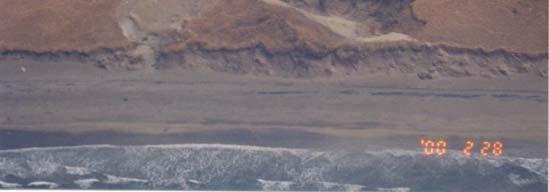
 FINAL REPORT FOR 2013 ON THE CONDITION OF THE MUNICIPAL OCEANFRONT BEACHES THE BOROUGH OF AVALON, CAPE MAY COUNTY, NEW JERSEY View from 12 th Street to the south taken February 28, 2013, following completion
A REVIEW OF THE CONDITION OF THE MUNICIPAL BEACHES AS A RESULT OF HURRICANE SANDY IN THE BOROUGH OF STONE HARBOR, CAPE MAY COUNTY, NEW JERSEY
 A REVIEW OF THE CONDITION OF THE MUNICIPAL BEACHES AS A RESULT OF HURRICANE SANDY IN THE BOROUGH OF STONE HARBOR, CAPE MAY COUNTY, NEW JERSEY View along the dune scarp from 103 rd Street on October 31,
Overview. Beach Features. Coastal Regions. Other Beach Profile Features. CHAPTER 10 The Coast: Beaches and Shoreline Processes.
 Overview CHAPTER 10 The Coast: Beaches and Shoreline Processes Coastal regions constantly change. The beach is a dominant coastal feature. Wave activity continually modifies the beach and coastal areas.
Beach profile surveys and morphological change, Otago Harbour entrance to Karitane May 2014 to June 2015
 Beach profile surveys and morphological change, Otago Harbour entrance to Karitane May 2014 to June 2015 Prepared for Port Otago Ltd Martin Single September 2015 Shore Processes and Management Ltd Contact
ATLANTIC COUNTY 2006 to 2008
 ATLANTIC COUNTY 2006 to 2008 The Atlantic County oceanfront shoreline consists of three barrier islands where the northern one, Little Beach Island and a third of the second, Brigantine Island, are undeveloped
Reading Material. Inshore oceanography, Anikouchine and Sternberg The World Ocean, Prentice-Hall
 Reading Material Inshore oceanography, Anikouchine and Sternberg The World Ocean, Prentice-Hall BEACH PROCESSES AND COASTAL ENVIRONMENTS COASTAL FEATURES Cross section Map view Terminology for Coastal
Volume and Shoreline Changes along Pinellas County Beaches during Tropical Storm Debby
 Volume and Shoreline Changes along Pinellas County Beaches during Tropical Storm Debby Ping Wang and Tiffany M. Roberts Coastal Research Laboratory University of South Florida July 24, 2012 Introduction
/50. Physical Geology Shorelines
 Physical Geology Shorelines Multiple Guess: (You know the drill 2 points each) 1. The path of movement of a water particle in a wave at sea is 1. circular 2. horizontal 3. vertical 4. elliptical 5. none
International Conference of Scour and Erosion
 International Conference of Scour and Erosion Long-term prediction of sediment budgets with dynamic cross-shore migration of sand spits Yoshihiro Hamada Yoshimitsu Tajima Bandula Wickramaarachchi Shinichi
Variation in Beach Profile and Sediment Characteristics at Popham Beach, Phippsburg, ME
 Colby College Digital Commons @ Colby Undergraduate Research Symposium Student Research 2006 Variation in Beach Profile and Sediment Characteristics at Popham Beach, Phippsburg, ME Kathryn Lidington Colby
Undertow - Zonation of Flow in Broken Wave Bores
 Nearshore Circulation Undertow and Rip Cells Undertow - Zonation of Flow in Broken Wave Bores In the wave breaking process, the landward transfer of water, associated with bore and surface roller decay
HURRICANE SANDY LIMITED REEVALUATION REPORT UNION BEACH, NEW JERSEY DRAFT ENGINEERING APPENDIX SUB APPENDIX D SBEACH MODELING
 HURRICANE SANDY LIMITED REEVALUATION REPORT UNION BEACH, NEW JERSEY DRAFT ENGINEERING APPENDIX SUB APPENDIX D SBEACH MODELING Rev. 18 Feb 2015 1 SBEACH Modeling 1.0 Introduction Following the methodology
Concepts & Phenomena
 Concepts & Phenomena in coastal and port sedimentation R. Kamalian Ports and Maritime Organization of Iran and PIANC-Iran 7 9 December 2015 What is the problem? Many harbours have sedimentation problems
SPECIAL SPRING 2018 STORM REPORT ON THE CONDITION OF THE MUNICIPAL BEACHES FOR THE BOROUGH OF STONE HARBOR, CAPE MAY COUNTY, NEW JERSEY
 SPECIAL SPRING 2018 STORM REPORT ON THE CONDITION OF THE MUNICIPAL BEACHES FOR THE BOROUGH OF STONE HARBOR, CAPE MAY COUNTY, NEW JERSEY Aerial photograph taken April 21, 2018 showing the view up the beach
COASTAL SYSTEMS WAVE ENERGY
 WAVE ENERGY The energy of a wave determines its ability to erode and transport material on the coast Wave energy depends on the fetch, the distance the wind has blown the wave Wind strength and wind duration
New Jersey Beach Profile Network Ocean County Profile Site Locations
 125 RICHARD STOCKTON COLLEGE OF NEW JERSEY COASTAL RESEARCH CENTER New Jersey Beach Profile Network Ocean County Profile Site Locations Figure 73 156 155 154 153 152 151 15 149 The Ocean County shoreline
Beach, dune and development in the Borough of Mantoloking as of January Prepared for The Borough of Mantoloking: April 2, 2008
 Summary of 20-years of Shoreline Monitoring Between Maryland Avenue, Point Pleasant Beach, Bay Head, Mantoloking, Brick Township, to 1 st Avenue in Normandy Beach, Ocean County, New Jersey & an Evaluation
Fact Sheet Ordinance Regulating Erosion Threatened Structures
 Fact Sheet Ordinance Regulating Erosion Threatened Structures Town of Duck, North Carolina August 15, 2011 What is being considered? The Town of Duck Council is considering an ordinance to limit the encroachment
Figure 38. Locations of the 28 NJBPN profile stations in Ocean County, NJ.
 52 Figure 38. Locations of the 28 NJBPN profile stations in Ocean County, NJ. 53 Individual Site Descriptions: Beaches in Northern Ocean County continued to recover slowly as sand transported offshore
Basic Dune Physical Characteristics
 Basic Dune Physical Characteristics New Jersey s Beach and Dune Characteristics Dunes in New Jersey are mainly confined to a narrow strip of land between the beach berm and upland development. While there
Chapter - Oceans and Coasts
 Chapter - Oceans and Coasts Discussion: What do oceans contribute to the environment of Earth? How do Earth s major systems relate to the oceans? Oceans and Coasts Oceans are important - Thermal regulation
Label the diagram below with long fetch and short fetch:
 Coastal Processes Coasts are shaped by the sea and the action of waves. The processes that take place are erosion, transportation and deposition. The power of waves is one of the most significant forces
Figure 38. Locations of the 28 NJBPN profile stations in Ocean County, NJ.
 55 Figure 38. Locations of the 28 NJBPN profile stations in Ocean County, NJ. 56 Individual Site Descriptions: Northern Ocean County recovered its beaches approaching pre-hurricane Sandy elevation or width,
Undertow - Zonation of Flow in Broken Wave Bores
 Lecture 22 Nearshore Circulation Undertow - Zonation of Flow in Broken Wave Bores In the wave breaking process, the landward transfer of water, associated with bore and surface roller decay within the
DUXBURY WAVE MODELING STUDY
 DUXBURY WAVE MODELING STUDY 2008 Status Report Duncan M. FitzGerald Peter S. Rosen Boston University Northeaster University Boston, MA 02215 Boston, MA 02115 Submitted to: DUXBURY BEACH RESERVATION November
Fauna Ryukyuana ISSN
 Fauna Ryukyuana ISSN 2187-6657 http://w3.u-ryukyu.ac.jp/naruse/lab/fauna_ryukyuana.html Records of the spotbase burrfish, Cyclichthys spilostylus (Tetraodontiformes: Diodontidae), from Okinawa-jima Island,
Shorelines Earth - Chapter 20 Stan Hatfield Southwestern Illinois College
 Shorelines Earth - Chapter 20 Stan Hatfield Southwestern Illinois College The Shoreline A Dynamic Interface The shoreline is a dynamic interface (common boundary) among air, land, and the ocean. The shoreline
STATUS REPORT FOR THE SUBMERGED REEF BALL TM ARTIFICIAL REEF SUBMERGED BREAKWATER BEACH STABILIZATION PROJECT FOR THE GRAND CAYMAN MARRIOTT HOTEL
 August 23 STATUS REPORT FOR THE SUBMERGED REEF BALL TM ARTIFICIAL REEF SUBMERGED BREAKWATER BEACH STABILIZATION PROJECT FOR THE GRAND CAYMAN MARRIOTT HOTEL performed by Lee E. Harris, Ph.D., P.E. Consulting
Beach Dune Performance Assessment of. New Jersey Beach Profile Network (NJBPN) Sites at. Long Beach Island, New Jersey. After Hurricane Sandy
 Sites at. Long Beach Island, New Jersey. After Hurricane Sandy") Beach Dune Performance Assessment of New Jersey Beach Profile Network (NJBPN) Sites at Long Beach Island, New Jersey After Hurricane Sandy November 13, 2012 The Richard Stockton College of NJ Coastal Research
Beach Dune Performance Assessment of New Jersey Beach Profile Network (NJBPN) Sites at Long Beach Island, New Jersey After Hurricane Sandy November 13, 2012 The Richard Stockton College of NJ Coastal Research
v.s. (GW) USD ( 07)/Wp 0.6 USD/Wp 1.8 MW
 USD ( 07)/Wp 0.6 USD/Wp 1.8 MW") 3 2 4 5 v.s. GW 65 55 45 35 25 15 4 3 2 5-5 21 22 23 24 25 26 27 28 29 21 211 212 213 214 215 1 Data from: GWEA, IAEA, Photon, Pla4s, 5 1965 197 1975 198 1985 199 1995 2 25 21 7 5, 45, 4, 35, 3, 25, 2,
3 2 4 5 v.s. GW 65 55 45 35 25 15 4 3 2 5-5 21 22 23 24 25 26 27 28 29 21 211 212 213 214 215 1 Data from: GWEA, IAEA, Photon, Pla4s, 5 1965 197 1975 198 1985 199 1995 2 25 21 7 5, 45, 4, 35, 3, 25, 2,
BEACH NOURISHMENT PROJECTS IN CARBONATE MATERIAL BEACH
 Submitted February, 2006 BEACH NOURISHMENT PROJECTS IN CARBONATE MATERIAL BEACH Ryuichiro Nishi 1, Robert G. Dean 2 and Mario P. de Leon 1 1 Department of Ocean Civil Engineering, Kagoshima University,
Earth Science Chapter 16 Section 3 Review
 Name: Class: Date: Earth Science Chapter 16 Section 3 Review Multiple Choice Identify the choice that best completes the statement or answers the question. 1. The movement of water that parallels the shore
LAB: WHERE S THE BEACH
 Name: LAB: WHERE S THE BEACH Introduction When you build a sandcastle on the beach, you don't expect it to last forever. You spread out your towel to sunbathe, but you know you can't stay in the same spot
Nearshore Placed Mound Physical Model Experiment
 Nearshore Placed Mound Physical Model Experiment PURPOSE: This technical note describes the migration and dispersion of a nearshore mound subjected to waves in a physical model. The summary includes recommendations
Soft Designs for a Harsh Climate: Trends in Coastal Engineering
 Alaska Department of Transportation & Public Facilities Ruth Carter, PE, and Harvey Smith, PE Coastal Engineering Section 20 October 2014 Soft Designs for a Harsh Climate: Trends in Coastal Engineering
Nearshore Morphodynamics. Bars and Nearshore Bathymetry. Sediment packages parallel to shore, that store beach sediment
 Nearshore Morphodynamics http://coastal.er.usgs.gov/bier/images/chandeleur-xbeach-lg.jpg Bars and Nearshore Bathymetry Sediment packages parallel to shore, that store beach sediment Can be up to 50 km
The evolution of beachrock morphology and its influence on beach morphodynamics
 The evolution of beachrock morphology and its influence on beach morphodynamics Robert J. Turner Division of Natural Sciences, Southampton College, 239 Montauk Highway, Southampton, NY 11968, U.S.A. email:
Long Beach Island Holgate Spit Little Egg Inlet Historical Evolution Introduction Longshore Transport Map, Survey and Photo Historic Sequence
 Appendix B Long Beach Island Holgate Spit Little Egg Inlet Historical Evolution Introduction The undeveloped southern end of Long Beach Island (LBI) is referred to as the Holgate spit as it adjoins the
Ocean Waves. Capillary. Gravity. Wind generated. Tides Tsunamis Seiches
 Ocean Waves Capillary Wind generated Gravity Tides Tsunamis Seiches Capillary waves are driven by the surface tension produced by electrically polarized water molecule San Pedro Lighthouse Waves are alternate
RESILIENCE THROUGH RESTORATION
 RESILIENCE THROUGH RESTORATION RECLAMATION DISTRICT NO. 1601 TWITCHELL ISLAND SAN JOAQUIN RIVER SETBACK LEVEE PROJECT TWITCHELL ISLAND BASICS Nearly 12 miles of levee Storm drainage facilities Protects
TITLE: COASTAL EROSION AND LANDFORMS.
 TITLE: COASTAL EROSION AND LANDFORMS. AIM: What are the factors that influence the formation of coastal features along Fishing Pond beach Trinidad? LOCATION OF FIELD STUDY: The study was carried out in
Photo by: Darryl Hatheway, 2011
 Photo by: Darryl Hatheway, 2011 September 11, 2015 Presentation Discussion Examine PFD V-Zone Mapping in Wave Runup Dominated West Coast Application of PFD V-Zone Mapping Criteria in Pacific G&S PFD V-Zone
The Physical and Human Causes of Erosion. The Holderness Coast
 The Physical and Human Causes of Erosion The Holderness Coast By The British Geographer Situation The Holderness coast is located on the east coast of England and is part of the East Riding of Yorkshire;
2016 NC Coastal Local Governments Annual Meeting
 2016 NC Coastal Local Governments Annual Meeting Coastal Flood Study Modeling and Mapping 101 April 21, 2016 Tom Langan, PE, CFM Engineering Supervisor NCEM Floodplain Mapping Program FEMA Coastal Flood
BEACH PROCESSES AND COASTAL ENVIRONMENTS
 BEACH PROCESSES AND COASTAL ENVIRONMENTS COASTAL FEATURES Cross section Map view TOPICS: Terminology Waves Beach Morphology Barriers Coastal Migration Tides Tidal Flats and Marshes Sediment Budgets Human
LOCALLY CONCENTRATED SEVERE BEACH EROSION ON SEISHO COAST CAUSED BY TYPHOON T0709
 F-4 Fourth International Conference on Scour and Erosion 2008 LOCALLY CONCENTRATED SEVERE BEACH EROSION ON SEISHO COAST CAUSED BY TYPHOON T0709 Yoshimitsu TAJIMA 1 and Shinji SATO 2 1 Member of JSCE, Associate
Chesil Beach, Dorset UK High energy, shingle coastline. Brighton Beach, Sussex UK Pebble beach
 Beaches: Depositional landform Extends from the highest high tide to the lowest low tide. Very important temporary store in coastal system. Accretion: sediment returning to the visible portion of a beach
HARBOUR SEDIMENTATION - COMPARISON WITH MODEL
 HARBOUR SEDIMENTATION - COMPARISON WITH MODEL ABSTRACT A mobile-bed model study of Pointe Sapin Harbour, in the Gulf of St. Lawrence, resulted in construction of a detached breakwater and sand trap to
Shore - place where ocean meets land Coast - refers to the larger zone affected by the processes that occur at this boundary.
 Waves, Beaches, and Coasts Shore - place where ocean meets land Coast - refers to the larger zone affected by the processes that occur at this boundary. Waves: energy moving through water The height of
COASTAL MORPHODYNAMICS
 COASTAL MORPHODYNAMICS PATRICIA CHARDÓN-MALDONADO, PHD, EIT Miguel Canals, Jack A. Puleo, Alec Torres-Freyermuth & Jens Figlus March 9, 2017 OUTLINE INTRODUCTION Meteorological Phenomena Forcing Conditions
Figure 41. Locations of the 28 NJBPN profile stations in Ocean County, NJ.
 57 Figure 41. Locations of the 28 NJBPN profile stations in Ocean County, NJ. 58 Hurricane Sandy s Impact on the Ocean County Shoreline; In general terms, all forms of damage to beaches, dunes and public
DUNE STABILIZATION AND BEACH EROSION
 DUNE STABILIZATION AND BEACH EROSION CAPE HATTERAS NATIONAL SEASHORE NORTH CAROLINA ROBERT DOLAN PAUL GODFREY U. S. DEPARTMENT OF INTERIOR NATIONAL PARK SERVICE OFFICE OF NATURAL SCIENCE WASHINGTON, D.
Evaluation of Placement Alternatives for Matagorda Ship Channel Bottleneck Removal
 Evaluation of Placement Alternatives for Matagorda Ship Channel Bottleneck Removal James Rosati III Ashley E. Frey CPT Grays Harbor, WA Wood Wood chips Flour Other CMS Shark River Inlet, NJ US Army Corps
2013 ANNUAL REPORT - TO THE CITY OF NORTH WILDWOOD ON THE CONDITION OF THE CITY BEACHES
 2013 ANNUAL REPORT - TO THE CITY OF NORTH WILDWOOD ON THE CONDITION OF THE CITY BEACHES View on June 18, 2013 from the 2 nd Avenue jetty looking south while the 2013 beach nourishment project was under
CROSS-SHORE SEDIMENT PROCESSES
 The University of the West Indies Organization of American States PROFESSIONAL DEVELOPMENT PROGRAMME: COASTAL INFRASTRUCTURE DESIGN, CONSTRUCTION AND MAINTENANCE A COURSE IN COASTAL DEFENSE SYSTEMS I CHAPTER
MULTIDECADAL SHORELINE EVOLUTION DUE TO LARGE-SCALE BEACH NOURISHMENT JAPANESE SAND ENGINE? Abstract
 MULTIDECADAL SHORELINE EVOLUTION DUE TO LARGE-SCALE BEACH NOURISHMENT JAPANESE SAND ENGINE? Masayuki Banno 1, Satoshi Takewaka 2 and Yoshiaki Kuriyama 3 Abstract Beach nourishment is one of the countermeasures
Essentials of Oceanography Eleventh Edition
 Chapter Chapter 1 10 Clickers Lecture Essentials of Oceanography Eleventh Edition The Coast: Beaches and Shoreline Processes Alan P. Trujillo Harold V. Thurman Chapter Overview Coastal regions have distinct
Figure 106. Locations of the 28 NJBPN profile stations in Ocean County, NJ.
 130 Figure 106. Locations of the 28 NJBPN profile stations in Ocean County, NJ. 131 2016-2017 Beach Fills in Ocean County: The federal/state/local storm damage reduction project (beachfill) between Manasquan
Exemplar for Internal Assessment Resource Geography Level 3. Resource title: The Coastal Environment Kaikoura
 Exemplar for internal assessment resource Geography 3.5A for Achievement Standard 91430 Exemplar for Internal Assessment Resource Geography Level 3 Resource title: The Coastal Environment Kaikoura This
2014 ANNUAL REPORT - TO THE CITY OF NORTH WILDWOOD ON THE CONDITION OF THE CITY BEACHES
 2014 ANNUAL REPORT - TO THE CITY OF NORTH WILDWOOD ON THE CONDITION OF THE CITY BEACHES View on September 25, 2014 looking northwest into Hereford Inlet. Considerable southerly expansion of the tip of
Oceans in Motion: Waves and Tides
 Oceans in Motion: Waves and Tides Waves Waves are among the most familiar features in the ocean. All waves work similarly, so although we are talking about ocean waves here, the same information would
Nearshore Waves and Erosion Model Quantifying the Coastal Protection Benefits Provided by Natural Habitats
 Nearshore Waves and Erosion Model Quantifying the Coastal Protection Benefits Provided by Natural Habitats SaveGuanaCayReef Marinehindsight.com Necessary to quantify protection services offered by natural
Understanding the Tsunami Wave
 The First Tsunami attack on Sri Lanka Krakatoa Island 27 th August 1883 Understanding the Tsunami Wave Generation Propagation Nearshore Transformation Shoreline Entry Inland Dissipation 1 Generation and
Beach Profiles. Topics. Module 9b Beach Profiles and Crossshore Sediment Transport 3/23/2016. CE A676 Coastal Engineering
 Beach Profiles AND CROSS-SHORE TRANSPORT Orson P. Smith, PE, Ph.D., Professor Emeritus Topics Features of beach and nearshore profiles Equilibrium profiles Cross-shore transport References Text (Sorensen)
Figure79. Location map for the 10 NJBPN profile sites in Atlantic County, NJ 155
 154 Figure79. Location map for the 10 NJBPN profile sites in Atlantic County, NJ 155 ATLANTIC COUNTY SPRING 2009 to FALL 2010 The Atlantic County coastline consists of three barrier islands. Between Little
Natural Bridges Field Trip Activity
 Natural Bridges Field Trip Activity This is due in class on MONDAY- March 1 - not in sections! Name TA: NOTE ON THE GRADING OF THIS ASSIGNMENT: Many of the questions below (especially in the tidepool part)
New Jersey Beach Profile Network Atlantic County Profile Site Locations
 215 RICHARD STOCKTON COLLEGE OF NEW JERSEY New Jersey Beach Profile Network Atlantic County Profile Site Locations COASTAL RESEARCH CENTER Figure 128 There are nine NJBPN survey sites on the Atlantic County
Geology of the Hawaiian Islands
 Geology of the Hawaiian Islands Class 24 8 April 2004 Any Questions? Rise and fall of sea level and its effect on Hawai`i Sea level Has fluctuated up and down many times in the geologic past Evidence?
Figure 46. Locations of the 28 NJBPN profile stations in Ocean County, NJ. A new site was added in the Borough of Seaside Heights (#248).
.") 90 Figure 46. Locations of the 28 NJBPN profile stations in Ocean County, NJ. A new site was added in the Borough of Seaside Heights (#248). 91 OCEAN COUNTY SPRING 2008 to FALL 2009 The Ocean County shoreline
90 Figure 46. Locations of the 28 NJBPN profile stations in Ocean County, NJ. A new site was added in the Borough of Seaside Heights (#248). 91 OCEAN COUNTY SPRING 2008 to FALL 2009 The Ocean County shoreline
Longshore sediment transport
 and Orson P. Smith, PE, Ph.D., Professor Emeritus Longshore transport Waves breaking at an angle to shore Sediment under breakers lifted by saltation Drops back to sea bed a little down drift Swash (runup)
City of Del Mar Local Coastal Plan (LCP) Amendment for Sea Level Rise and Coastal Flooding
 Amendment for Sea Level Rise and Coastal Flooding") City of Del Mar Local Coastal Plan (LCP) Amendment for Sea Level Rise and Coastal Flooding 6/22/17 Presentation to Sea Level Rise Stakeholder- Technical Advisory Committee (STAC) Nick Garrity, P.E. Lindsey
City of Del Mar Local Coastal Plan (LCP) Amendment for Sea Level Rise and Coastal Flooding 6/22/17 Presentation to Sea Level Rise Stakeholder- Technical Advisory Committee (STAC) Nick Garrity, P.E. Lindsey
BEACH NOURISHMENT COMBINED WITH SIC VERTICAL DRAIN IN MALAYSIA. Claus Brøgger 1 and Poul Jakobsen 2
 BEACH NOURISHMENT COMBINED WITH SIC VERTICAL DRAIN IN MALAYSIA. Claus Brøgger 1 and Poul Jakobsen 2 The present paper presents measurements and results from a three year full scale Pilot Project with the
Estuarine Shoreline Stabilization
 Estuarine Shoreline Stabilization Property Owner s Guide to Determining the Most Appropriate Stabilization Method Estuarine shorelines are dynamic features that experience continued erosion. Land is lost
Marginal Marine Environments
 Marginal Marine Environments Delta: discrete shoreline protuberances formed where rivers enter oceans, semi-enclosed seas, lakes or lagoons and supply sediment more rapidly than it can be redistributed
The History of Coastal Flood Hazard Assessments in the Great Lakes
 The History of Coastal Flood Hazard Assessments in the Great Lakes Brian A. Caufield, P.E., CFM June 23, 2016 2 The Great Lakes Some Statistics Courtesy of Great Lakes Information Network One-fifth of
USE OF SEGMENTED OFFSHORE BREAKWATERS FOR BEACH EROSION CONTROL
 .. CETN-III-22 4/84 PURPOSE: USE OF SEGMENTED OFFSHORE BREAKWATERS FOR BEACH EROSION CONTROL To provide information on the functional application of and general design considerations for using offshore
MODELING OF CLIMATE CHANGE IMPACTS ON COASTAL STRUCTURES - CONTRIBUTION TO THEIR RE-DESIGN
 Proceedings of the 14 th International Conference on Environmental Science and Technology Rhodes, Greece, 3-5 September 2015 MODELING OF CLIMATE CHANGE IMPACTS ON COASTAL STRUCTURES - CONTRIBUTION TO THEIR
FINAL REPORT FOR 2013 ON THE CONDITION OF THE MUNICIPAL BEACHES IN THE TOWNSHIP OF UPPER, CAPE MAY COUNTY, NEW JERSEY
 FINAL REPORT FOR 2013 ON THE CONDITION OF THE MUNICIPAL BEACHES IN THE TOWNSHIP OF UPPER, CAPE MAY COUNTY, NEW JERSEY Aerial photograph at Corson s Inlet showing conditions on December 1, 2013 of the north
Coastal Processes and Landforms
 Coastal Processes and Landforms These icons indicate that teacher s notes or useful web addresses are available in the Notes Page. This icon indicates that the slide contains activities created in Flash.
There are many different kinds of beaches which are generally characterized by the dominance of waves, tides, rivers and currents, and in particular
 Fig. 11-11, p. 253 There are many different kinds of beaches which are generally characterized by the dominance of waves, tides, rivers and currents, and in particular differ by the amount of energy, which
A Preliminary Review of Beach Profile and Hardbottom Interactions
 A Preliminary Review of Beach Profile and Hardbottom Interactions Douglas W. Mann, P.E., D.CE. CB&I A World of Solutions Presentation Goal Lead to a better understanding of the challenges regarding the
Chronic coastal erosion is a statewide problem
 Chronic coastal erosion is a statewide problem 1 Seawalls are constructed where there is erosion, but they do not solve the erosion they often worsen it along adjacent shores. Hawaii needs erosion solutions.
SHOREHAM BEACH LOCAL NATURE RESERVE
 SHOREHAM BEACH LOCAL NATURE RESERVE Coastal Geography Education Programme 2014-15 S. Savage 2014 COASTAL GEOGRAPHY OPPORTUNITIES Shoreham Beach Shoreham Beach is a shingle spit formed over many centuries