St Ives Head to Godrevy Head
|
|
|
- Marshall Butler
- 6 years ago
- Views:
Transcription
 The stretch of coast between St Ives and Godrevy contains 10 beaches,")


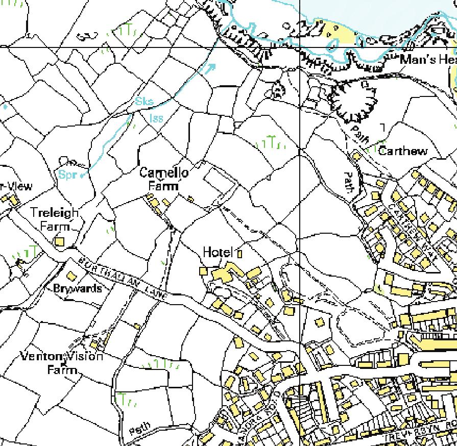
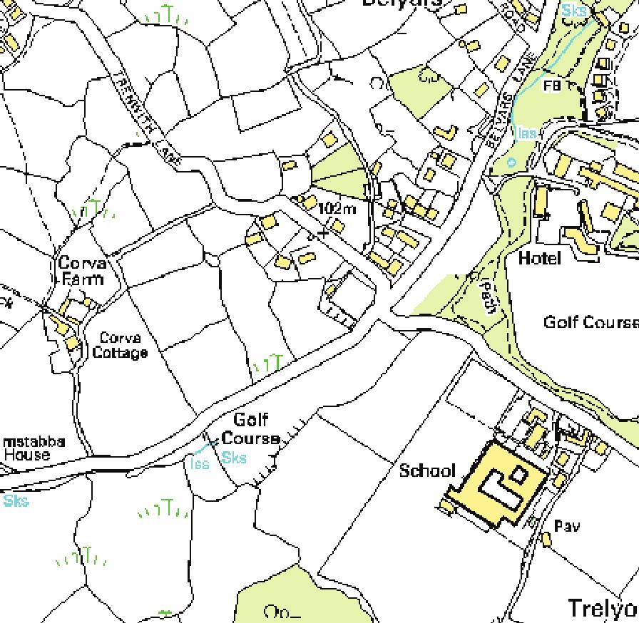
1 Chapter 2 St Ives Head to Godrevy Head Figure 2.1 St Ives Head to Godrevy Head (scale 1:38794) The stretch of coast between St Ives and Godrevy contains 10 beaches, comprising a total area of 2,802,500 m 2. St Ives Bay, 20 square kilometres in area and 7km at its widest extent, is a major sediment sink, with the beaches, dunes and Hayle estuary storing regionally important volumes of sand. This is a closed sedimentary system with little/no input of sediment from adjacent stretches of coastline. This means that sediment eroded from local sources such as raised-beach deposits and sand dunes, is likely to remain within individual embayments and undergo periodic redistribution within the Bay [Halcrow, 2002]. Between Hayle and Godrevy there is potential for north-eastward sediment transport, however there is little evidence of sediment accumulating against Godrevy Head [Halcrow, 2002]. St Ives Bay has formed where the sea has cut in lee of relatively resistant granite rocks which make up the cliffs between St Ives Head and Lands End. In St Ives Bay the geology becomes Devonian silty slates, mudstones, sandstones and limestones. Godrevy Point and 25
2 26 Navax Point are possibly more resistant to erosion due to bands of sandstones in the slates [Halcrow, 2002]. There are limited amounts (less than 1m thick) of sand offshore in the Bay although these are not thought to have a strong interaction with shoreline sediments [Halcrow, 2002]. St Ives Bay is sheltered from the dominant south-westerly/westerly waves. Most of the beaches are swash-aligned to waves with roughly equal movement in either direction, although there is a tendency for longshore drift to deflect the north-oriented low-water harbour channel to the east. There is uncertainty over the exact nature of sediment movements within the Bay, particularly the alongshore movements which are likely to be most important for shorelines and beach plan shapes [Halcrow, 2002]. The beaches would be expected to retain their overall shape because of continual inputs of carbonate material from marine organisms, with possibly some additional material from the erosion of cliff heads and slopes. Local dune erosion in the un-sheltered section between Carbis and Godrevy would be expected to continue during storms. Figure 2.2 Bathymetry of St Ives Bay. Source: Marine Digimap
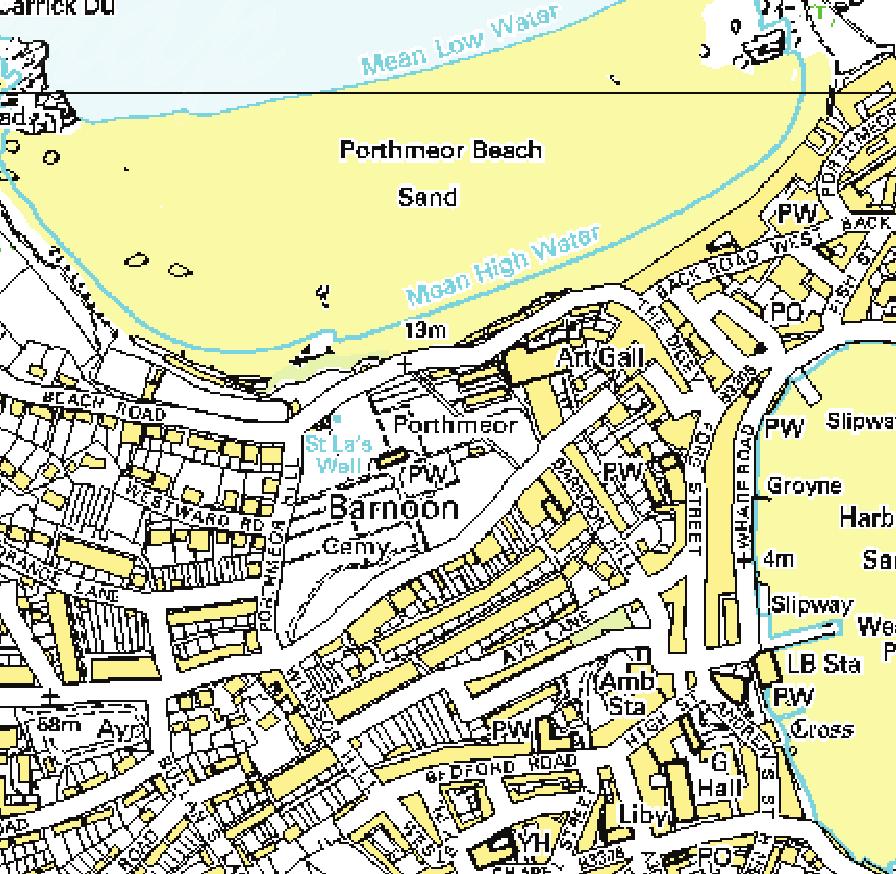
3 Porthmeor Porthmeor The Island headland separates Porthmeor to the west, and Porth Gwidden, Harbour Sand and Porth Minster to the east. These are wide sand beaches composed of carbonate material. Porthmeor (SW515410) is one of the most popular surfing beaches in Cornwall. The rocky headlands separating the beaches in this part of St Ives Bay are composed of dolerite and gabbro, and the beaches are backed by cliffs and head deposits [Halcrow, 2002]. Table 2.1 Porthmeor Beach - Physical Attributes Easting (m) Northing (m) Latitude 50 o N Longitude 5 o W Local authority Penwith Council Management Unit Porthmeor 7A2-02 MSR (m) 5.77 Length (m) 550 LW Length (m) 550 Width (m) 200 Area (m 2 ) Angle ( o ) 350 Angle Code NNW Morphological Classification Open coast beach. Sediment Classification High water sand and rock; low water sand. Table 2.2 Porthmeor Beach - Sediment Attributes (08/11/2007) Lower Upper Mean (ψ) (0.17 mm) (0.11 mm) Sorting (ψ) 0.35 (0.78 mm) 0.24 (0.85 mm) Skewness Mean fall vel (cm/s) D 50 (Hallermeier equation, mm) CaCO 3 % ± 0.61 n/a
4 28 Porthmeor Figure 2.3 Digital Elevation Model of Porthmeor Beach, Elevations in m (ODN) 0 ODN (MSL) marked. Data courtesy of the Plymouth Coastal Observatory.


")
5 Porthmeor 29 Figure 2.4 Porthmeor Beach (scale 1:7831)
6 30 Porth Gwidden 2.2 Porth Gwidden A sheltered sandy cove (SW ) backed by stone walkways. The composition of beach sediments indicates that shell material is the primary source of sand, with carbonate contents up to 80%. The remaining proportion is accounted for by inputs from the erosion of cliffs adjacent to and backing sections of beach. Table 2.3 Porth Gwidden Beach - Physical Attributes Easting (m) Northing (m) Latitude 50 o N Longitude 5 o W Local authority Penwith Council Management Unit St Ives 7A2-04 MSR (m) 5.77 Length (m) 100 LW Length (m) 100 Width (m) 100 Area (m 2 ) Angle ( o ) 80 Angle Code ENE; relatively sheltered Morphological Classification Open coast beach. Sediment Classification High water sand and rock; low water sand.


7 Porth Gwidden 31 Figure 2.5 Porth Gwidden Beach (scale 1:7831)
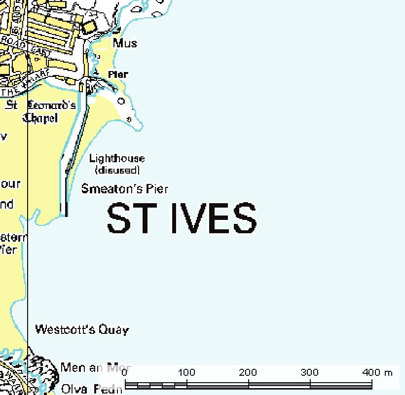
8 32 Harbour Sand 2.3 Harbour Sand St Ives Harbour Beach is a small sandy beach in centre of St Ives beside the harbour and sheltered by the harbour wall (Smeaton Pier, built in 1770). There are numerous hard defences around St Ives including seawalls and harbour piers, which act to trap a large volume of sediment within and adjacent to the harbour. Seawalls run continuously behind Porthmeor, Porth Gwidden and Harbour beaches, and in the central portions of Porth Minster and Carbis Bay. Sand accumulating against the back of Porthmeor beach is annually re-profiled to lower parts of the beach. This practice possibly prevents the formation of supra-tidal dune systems [Halcrow, 2002]. The harbour is one of the few places between Lands End and Newquay where trailer-bourne boats can be launched. Table 2.4 Harbour Sand Beach - Physical Attributes Easting (m) Northing (m) Latitude 50 o N Longitude 5 o W Local authority Penwith Council Management Unit St Ives 7A2-04 MSR (m) 5.77 Length (m) 400 LW Length (m) 400 Width (m) 150 Area (m 2 ) Angle ( o ) 110 Angle Code ESE; relatively sheltered Morphological Classification Open coast beach with breakwaters and groyne. Sediment Classification High water sand and rock; low water sand.
9 Harbour Sand 33 Figure 2.6 Digital Elevation Model of St Ives Harbour Beach, Elevations in m (ODN) 0 ODN (MSL) marked. Data courtesy of the Plymouth Coastal Observatory.


10 34 Harbour Sand Figure 2.7 Harbour Sand Beach (scale 1:7831)
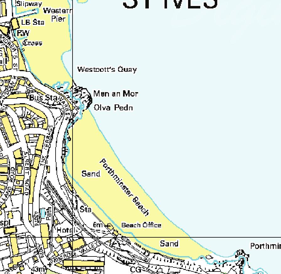
11 Porth Minster Porth Minster This gently sloping sheltered beach (SW522402) has a mild microclimate, and is popular with families. Table 2.5 Porth Minster Beach - Physical Attributes Easting (m) Northing (m) Latitude 50 o N Longitude 5 o W Local authority Penwith Council Management Unit St Ives 7A2-04 MSR (m) 5.77 Length (m) 600 LW Length (m) 600 Width (m) 100 Area (m 2 ) Angle ( o ) 50 Angle Code NE; relatively sheltered Morphological Classification Open coast beach. Sediment Classification High water sand and rock; low water sand.


12 36 Porth Minster Figure 2.8 Porthminster Beach (scale 1:7831)
13 Carbis Bay Carbis Bay This family-orientated beach (SW ) is privately owned by the Carbis Bay Hotel, approximately 2 miles from St Ives. The beach is protected both by it s aspect and the large tree covered cliffs, which is rare on the exposed north Cornish coast. From Carbis Bay to Godrevy Point the coastline is composed entirely of sedimentary rocks with Devonian slates, which form a relatively low-relief shoreline. Table 2.6 Carbis Bay Beach - Physical Attributes Easting (m) Northing (m) Latitude 50 o N Longitude 5 o W Local authority Penwith Council Management Unit West of Porth Kidney 7A2-05 MSR (m) 5.81 Length (m) 1000 LW Length (m) 1000 Width (m) 150 Area (m 2 ) Angle ( o ) 20 Angle Code NNE; relatively sheltered Morphological Classification Open coast beach. Sediment Classification High water sand; low water sand. Table 2.7 Carbis Bay Beach - Sediment Attributes (08/11/2007) Lower Upper Mean (ψ) (0.20 mm) (0.21 mm) Sorting (ψ) 0.38 (0.77 mm) 0.34 (0.79 mm) Skewness Mean fall vel (cm/s) D 50 (Hallermeier equation, mm) CaCO 3 % ± 5.18 n/a
14 38 Carbis Bay Figure 2.9 Digital Elevation Model of Carbis Bay Beach, Elevations in m (ODN) 0 ODN (MSL) marked. Data courtesy of the Plymouth Coastal Observatory.

15 Carbis Bay 39 Figure 2.10 Carbis Beach at low tide.


")
16 40 Carbis Bay Figure 2.11 Carbis Bay or Barrepta Cove Beach (scale 1:7831)
17 Porth Kidney Sands and Hayle Estuary Porth Kidney Sands and Hayle Estuary Porth Kidney is a large sandy beach in front of the sand dunes of Lelant and adjacent to the mouth of the Hayle estuary. The Hayle is a small estuary formed from the valleys of the Rivers Hayle, St. Erth and Angarrack, which join at the harbour head and which have become infilled following their inundation by post-glacial sea-level rise. The Hayle river is of Tertiary age, and is thought to have been deepened and modified by periglacial meltwater. Hayle estuary has been infilled with sediment to such a level that its tidal prism is very small and has little direct impact upon the adjacent open coast [Halcrow, 2002]. Indeed, up to 34m of alluvium lies on the bed of the river Hayle, siltation caused by the deposition of fines from tin mining centres. Ebb-tidal dominance ensures that sand is transported into Hayle estuary, deposited as a bank at the mouth of the harbour [Bird, 1998]. This bank is actively extracted to aid navigation, and some is carried into the entrance channel from where it may be flushed back to the shoreline by the strong ebb tide [Halcrow, 2002]. Further upstream, sparse saltmarshes have grown in the muddy sediment south of Lelant [Bird, 1998]. Hayle estuary is regarded as an international quality bird-watching spot: sightings include Avocets, Ospreys and a host of wading birds. Hayle estuary has been heavily modified by various walls and sluices, however it is unlikely that this has significantly reduced its interaction with the open coast. Sand is also removed from a bank at the mouth of the harbour to aid navigation [Halcrow, 2002]. Table 2.8 Porth Kidney Beach - Physical Attributes Easting (m) Northing (m) Latitude 50 o N Longitude 5 o W Local authority Penwith Council Management Unit Hayle 7A1-06 MSR (m) 5.81 Length (m) 1350 LW Length (m) 6450 Width (m) 500 Area (m 2 ) Angle ( o ) 0 Angle Code NNE Morphological Classification Open coast beach with high cliff. Sediment Classification High water rock and sand; low water sand.
18 42 Porth Kidney Sands and Hayle Estuary Table 2.9 Porth Kidney Beach - Sediment Attributes (08/11/2007) Lower Upper Mean (ψ) (0.23 mm) (0.22 mm) Sorting (ψ) 0.45 (0.73 mm) 0.31 (0.80 mm) Skewness Mean fall vel (cm/s) D 50 (Hallermeier equation, mm) CaCO 3 % ± 0.64 n/a In 1985, the D 50 at Porth Kidney was 0.35 mm [Goudie, 1990], compared with in 2007 (Table 2.2). The CaCO 3 content in 1985 was 56.8% [Goudie, 1990], and in 2007 it was 62%.
19 Porth Kidney Sands and Hayle Estuary Elevation (m, ODN) x Easting (m) x Northing (m) Figure 2.12 Digital Elevation Model of Hayle, Elevations in m (ODN) 0 ODN (MSL) marked. Data courtesy of the Plymouth Coastal Observatory.


")
20 44 Porth Kidney Sands and Hayle Estuary Figure 2.13 Porth Kidney or Hayle Beach (scale 1:7831)
21 Phillack Towans Phillack Towans The dune system east of Hayle extends some 3km and over 1km inland, known as the Phillack/Hayle (SW554388), Upton, and Gwithian Towans, banked to heights of over 60m. The dunes overlie cliffs of bedrock and head or raised-beach deposits, and in some places even old mine waste [Halcrow, 2002]. Blown sand also covers parts of the western side of Godrevy Point at the northern end of St Ives Bay [Halcrow, 2002]. There has been only limited research at this site [Steers, 1964; Balchin, 1954; Hosking and Ong, 1963]. Black Cliff is an outcrop of the Porthtowan Formation [Bird, 1998], which are steep sandstones. The beach and dunes are carbonate-rich because they are primarily composed of shell material, and have varying patterns of erosion and accretion. The beach sands contain both tin and other heavy metals which have preseumably been carried to the beach from streams [Hosking and Ong, 1963]. This site is unusual within the UK because there are few sites where erosional forms are being exposed by the removal of dunes. As dunes to the south have been eroded they have exposed former cliffs, caves and stacks [May and Hansom, 2003]. Table 2.10 Phillack Towans Beach and Dunes - Physical Attributes Easting (m) Northing (m) Latitude 50 o N Longitude 5 o W Local authority Penwith Council Management Unit Godrevy 7A2-07 MSR (m) 5.84 Length (m) 2050 LW Length (m) 2050 Width (m) 350 Area (m 2 ) Angle ( o ) 330 Angle Code NNW Morphological Classification Open coast beach with high dunes. Sediment Classification High water sand; low water sand.


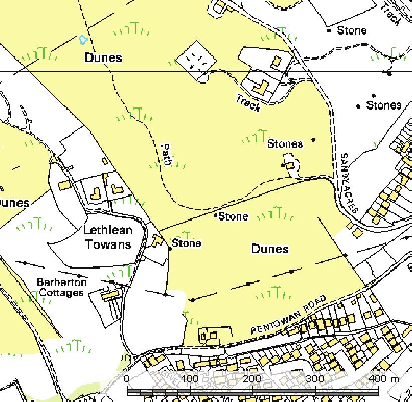
22 46 Phillack Towans Figure 2.14 Phillack Towans (scale 1:7831)
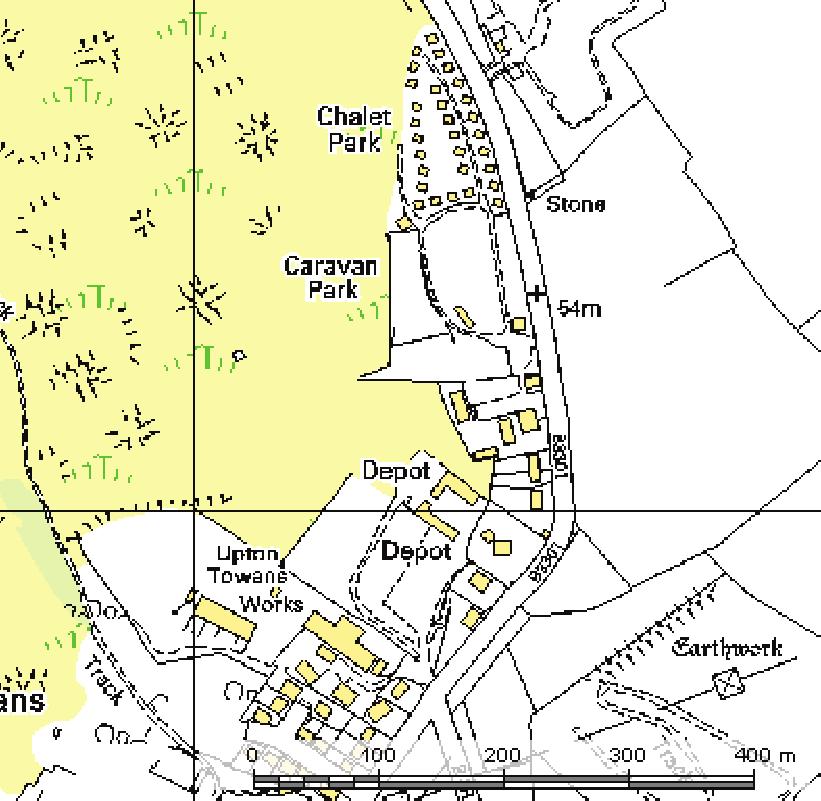
23 Upton or Mexico Towans Upton or Mexico Towans There has been significant extraction of sand from the dunes northeast of Hayle, in particular Mexico Towans (to the south) and Upton Towans (to the north) where the dunes have been almost entirely removed and a bund has been constructed across the back of the beach to prevent inundation [Halcrow, 2002]. The dunes are dissected by blowouts [Bird, 1998]. Table 2.11 Upton Towans Beach and Dunes - Physical Attributes Easting (m) Northing (m) Latitude 50 o N Longitude 5 o W Local authority Penwith Council Management Unit Godrevy 7A2-07 MSR (m) 5.86 Length (m) 1400 LW Length (m) 1400 Width (m) 30 Area (m 2 ) Angle ( o ) 31 Angle Code NW Morphological Classification Open coast beach with high dunes. Sediment Classification High water sand; low water sand.
24 48 Upton or Mexico Towans Elevation (m, ODN) x Northing (m) x 10 Easting (m) Figure 2.15 Digital Elevation Model of Hayle to Gwithian, Elevations in m (ODN) 0 ODN (MSL) marked. Data courtesy of the Plymouth Coastal Observatory.


")
25 Upton or Mexico Towans 49 Figure 2.16 Upton Towans (scale 1:7831)
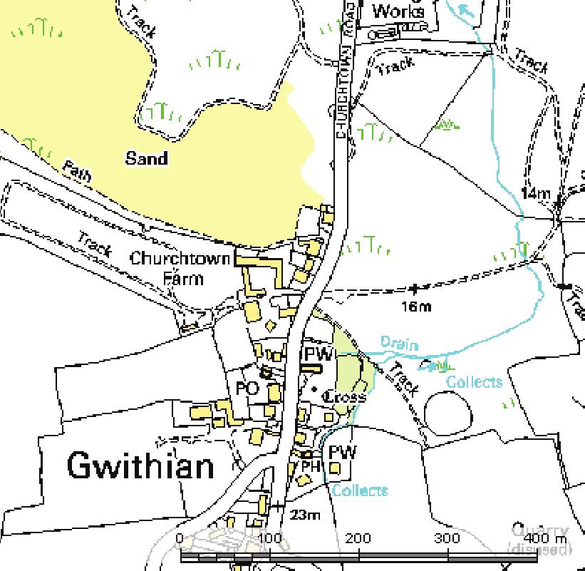
26 50 Gwithian Towans 2.9 Gwithian Towans Gwithian (SW581417) is a sandy bay interspersed with rocks, popular with surfers. This Geological Conservation Review (GCR) and Blue Flag site is formed at its southern end by active climbing dunes which reach over 25m in height [May and Hansom, 2003]. Gwithian village was named after the obscure St. Gwthian, who was patron saint of good fortune on the sea. A fifth century church and the relics of St. Gwithian were uncovered on the beach itself in the last century but reclaimed by the sand. The beach also covers the remains of a Bronze Age farm [Steers, 1964]. Through Gwithian Towans runs the Red River, named after oxidised tin residues from the tin mines around Reduth and Camborne. Nowadays it is running clear, however it is in fact still heavily contaminated. The fact that Gwithian Towans rests high on head deposits which themselves rest on fossiled dunes suggests that dunes have existed at this site for tens of thousands of years [Bird, 1998]. Table 2.12 Gwithian Towans Beach and Dunes - Physical Attributes Easting (m) Northing (m) Latitude 50 o N Longitude 5 o W Local authority Penwith Council Management Unit Godrevy 7A2-07 MSR (m) 5.87 Length (m) 1500 LW Length (m) 1500 Width (m) 300 Area (m 2 ) Angle ( o ) 295 Angle Code WNW Morphological Classification Open coast beach with high dunes. Sediment Classification High water sand; low water sand. Table 2.13 Gwithian Beach - Sediment Attributes (08/11/2007) Lower Upper Mean (ψ) (0.31 mm) (0.29 mm) Sorting (ψ) 0.44 (0.74 mm) 0.39 (0.76 mm) Skewness Mean fall vel (cm/s) D 50 (Hallermeier equation, mm) CaCO 3 % ± n/a
27 Gwithian Towans 51 Figure 2.17 Digital Elevation Model of Gwithian Beach, 11/02/2008. Elevations in m (ODN) 0 ODN (MSL) marked.


28 52 Gwithian Towans Figure 2.18 Gwithian Towans (scale 1:7831)
29 Godrevy Cove Godrevy Cove The coastline here, 4 miles from Hayle, is run by the National Trust. Navax Point hosts Godrevy Lighthouse 50 miles offshore, built in 1859 and immortalised by Virginia Woolfe s novel To The Lighthouse. In the summer, porpoises are frequent visitors to the rather strong tidal currents that sweep around the headland. The dunes at Gwithian undergoing erosion are gradually replaced at the shoreline by a small rock cliff upon which they rest. This cliff reaches about 20 m in height south of Peter s Point before declining towards 15 m around Strap Rocks. Between Peter s Point and the northern boundary of the site (SW ), the cliff is broken by small coves, stacks and caves associated with lines of weakness in the Lower Devonian rocks [May and Hansom, 2003]. At Godrevy Point the sand has been cemented to form a porous sandstone called beachstone. Table 2.14 Godrevy Cove - Physical Attributes Easting (m) Northing (m) Latitude 50 o N Longitude 5 o W Local authority Penwith Council Management Unit Godrevy 7A2-07 MSR (m) 5.88 Length (m) 150 LW Length (m) 150 Width (m) 100 Area (m 2 ) Angle ( o ) 240 Angle Code WSW Morphological Classification Open coast beach with dunes and low cliffs. Sediment Classification High water rock and sand; low water sand.

30 54 Godrevy Cove Figure 2.19 Godrevy Beach at low tide

31 Godrevy Cove 55 Figure 2.20 Godrevy Cove (scale 1:7831)
32 56 Godrevy Cove
PDZ: 10 Clodgy Point to Godrevy Point Management Area 25 Management Area 26 Management Area 27 Management Area 28
 PDZ: 10 Clodgy Point to Godrevy Point Management Area 25 Management Area 26 Management Area 27 Management Area 28 Looking toward Hayle from Godrevy Towans Clodgy Point to Godrevy Point This area encompasses
PDZ: 10 Clodgy Point to Godrevy Point Management Area 25 Management Area 26 Management Area 27 Management Area 28 DRAFT
 PDZ: 10 Clodgy Point to Godrevy Point Management Area 25 Management Area 26 Management Area 27 Management Area 28 Clodgy Point to Godrevy Point This area encompasses St Ives Bay and is made up of both
Chapter 10 Lecture Outline. The Restless Oceans
 Chapter 10 Lecture Outline The Restless Oceans Focus Question 10.1 How does the Coriolis effect influence ocean currents? The Ocean s Surface Circulation Ocean currents Masses of water that flow from one
The Coastal Geomorphology of North Cornwall: St. Ives Head to Trevose Head.
 The Coastal Geomorphology of North Cornwall: St. Ives Head to Trevose Head. by DANIEL D. BUSCOMBE & TIMOTHY M. SCOTT Wave Hub Impact on Seabed and Shoreline Processes (WHISSP) University of Plymouth. c
Overview. Beach Features. Coastal Regions. Other Beach Profile Features. CHAPTER 10 The Coast: Beaches and Shoreline Processes.
 Overview CHAPTER 10 The Coast: Beaches and Shoreline Processes Coastal regions constantly change. The beach is a dominant coastal feature. Wave activity continually modifies the beach and coastal areas.
Shorelines Earth - Chapter 20 Stan Hatfield Southwestern Illinois College
 Shorelines Earth - Chapter 20 Stan Hatfield Southwestern Illinois College The Shoreline A Dynamic Interface The shoreline is a dynamic interface (common boundary) among air, land, and the ocean. The shoreline
Australian Coastal Councils Conference
 Australian Coastal Councils Conference Kiama March 2019 Where Has My Beach Gone? (and what can I do about it?) Dr Andrew McCowan Water Technology Where Has My Beach Gone? Where Has My Beach Gone? Where
Chesil Beach, Dorset UK High energy, shingle coastline. Brighton Beach, Sussex UK Pebble beach
 Beaches: Depositional landform Extends from the highest high tide to the lowest low tide. Very important temporary store in coastal system. Accretion: sediment returning to the visible portion of a beach
Oceans and Coasts. Chapter 18
 Oceans and Coasts Chapter 18 Exploring the oceans The ocean floor Sediments thicken and the age of the seafloor increases from ridge to shore The continental shelf off the northeast United States Constituent
Coasts. 1. Coastal Processes. 1.1 Coastal erosion. 1.2 Sediment transport. Coastal Processes and Landforms. i. Hydraulic action
 Coasts Coastal Processes and Landforms 1. Coastal Processes 1.1 Coastal erosion i. Hydraulic action When waves strike against a rock surface, the waves trap air in the rock joints. This air is compressed
Coastal Change and Conflict
 Coastal Change and Conflict Outline of the Topic Contrasting Coasts why do all coasts not look the same? Geology of the coast the impact rock structure has on the coastline Waves Constructive and destructive
Anatomy of Coastal Regions
 The Coast I. BEACH ANATOMY Anatomy of Coastal Regions Terms for different parts of beaches and coastal regions Are all about ENERGY- ie, where the ocean s energy Mostly through tides and waves, and shape
Label the diagram below with long fetch and short fetch:
 Coastal Processes Coasts are shaped by the sea and the action of waves. The processes that take place are erosion, transportation and deposition. The power of waves is one of the most significant forces
Marginal Marine Environments
 Marginal Marine Environments Delta: discrete shoreline protuberances formed where rivers enter oceans, semi-enclosed seas, lakes or lagoons and supply sediment more rapidly than it can be redistributed
page - Laboratory Exercise #5 Shoreline Processes
 page - Laboratory Exercise #5 Shoreline Processes Section A Shoreline Processes: Overview of Waves The ocean s surface is influenced by three types of motion (waves, tides and surface currents). Shorelines
Chapter. The Dynamic Ocean
 Chapter The Dynamic Ocean An ocean current is the mass of ocean water that flows from one place to another. 16.1 The Composition of Seawater Surface Circulation Surface Currents Surface currents are movements
Lecture Outlines PowerPoint. Chapter 15 Earth Science, 12e Tarbuck/Lutgens
 Lecture Outlines PowerPoint Chapter 15 Earth Science, 12e Tarbuck/Lutgens 2009 Pearson Prentice Hall This work is protected by United States copyright laws and is provided solely for the use of instructors
The Sea Geography Notes JC-Learn. JC-Learn. Geography Notes The Sea. 1 P a g e
 JC-Learn Geography Notes The Sea 1 P a g e The Sea *Here, you can choose to study the chapter on glaciation or the one on the sea, or even both, because whenever these topics come up in the Junior Cert
Coastal management has lagged behind the growth in population leading to problems with pollution
 Fifty percent of the population of the industrialized world lives within 100 km of a coast. Coastal management has lagged behind the growth in population leading to problems with pollution and natural
Earth Science Chapter 16 Section 3 Review
 Name: Class: Date: Earth Science Chapter 16 Section 3 Review Multiple Choice Identify the choice that best completes the statement or answers the question. 1. The movement of water that parallels the shore
1.5 Understand how ocean waves and currents change the face of coastal areas. (Chapter 3)
") 1.5 Understand how ocean waves and currents change the face of coastal areas. (Chapter 3) 1. Hydraulic Action/Pressure - air being forced into crack in rocks. 2. Corrosion (Solution) Minerals such as calcium
1.5 Understand how ocean waves and currents change the face of coastal areas. (Chapter 3) 1. Hydraulic Action/Pressure - air being forced into crack in rocks. 2. Corrosion (Solution) Minerals such as calcium
Chapter 20 Lecture. Earth: An Introduction to Physical Geology. Eleventh Edition. Shorelines. Tarbuck and Lutgens Pearson Education, Inc.
 Chapter 20 Lecture Earth: An Introduction to Physical Geology Eleventh Edition Shorelines Tarbuck and Lutgens The Shoreline: A Dynamic Interface The Coastal Zone The shoreline is constantly modified by
Apostle Islands National Seashore
 Apostle Islands National Seashore David Speer & Phillip Larson October 2 nd Fieldtrip Report Table of Contents Introduction 1 Stop 1: Apostle Island Boat Cruise 1 Stop 2: Coastal Geomorphology 5 Stop 3:
Essentials of Oceanography Eleventh Edition
 Chapter Chapter 1 10 Clickers Lecture Essentials of Oceanography Eleventh Edition The Coast: Beaches and Shoreline Processes Alan P. Trujillo Harold V. Thurman Chapter Overview Coastal regions have distinct
Coastal Processes Day Criccieth
 Coastal Processes Rivers (Conwy) Rivers (Peris) Urban Studies Lowland Glaciation Tourism and National Parks Soils Sand Dunes Upland Glaciation Rural Settlements The Centre and Staff Fieldwork Equipment
Nearshore Sediment Transport What influences the loss of sediment on Beaches? - Waves - Winds - Tidal Currents - River discharge - Runoff
 Tides & Beaches Nearshore Sediment Transport What influences the loss of sediment on Beaches? - Waves - Winds - Tidal Currents - River discharge - Runoff Oceans Ocean Topography Physical Structure of the
LAKKOPETRA (GREECE) EUROSION Case Study. Contact: Kyriakos SPYROPOULOS. TRITON Consulting Engineers. 90 Pratinou Str Athens (GREECE)
 EUROSION Case Study. Contact: Kyriakos SPYROPOULOS. TRITON Consulting Engineers. 90 Pratinou Str Athens (GREECE)") LAKKOPETRA (GREECE) Contact: Kyriakos SPYROPOULOS TRITON Consulting Engineers 90 Pratinou Str. 11634 Athens (GREECE) Tel: +32 10 729 57 61 Fax: +32 10 724 33 58 e-mail: kspyropoulos@tritonsa.gr 19 1 1.
LAKKOPETRA (GREECE) Contact: Kyriakos SPYROPOULOS TRITON Consulting Engineers 90 Pratinou Str. 11634 Athens (GREECE) Tel: +32 10 729 57 61 Fax: +32 10 724 33 58 e-mail: kspyropoulos@tritonsa.gr 19 1 1.
COASTAL SYSTEMS WAVE ENERGY
 WAVE ENERGY The energy of a wave determines its ability to erode and transport material on the coast Wave energy depends on the fetch, the distance the wind has blown the wave Wind strength and wind duration
Studland Bay Context and Learning Aims
 Studland Bay Enquiry 7: How are coastal processes affecting Studland Bay? Context and Learning Aims Pupils will be supported in and outside of the classroom to: Identify; describe and explain the physical
Beach profile surveys and morphological change, Otago Harbour entrance to Karitane May 2014 to June 2015
 Beach profile surveys and morphological change, Otago Harbour entrance to Karitane May 2014 to June 2015 Prepared for Port Otago Ltd Martin Single September 2015 Shore Processes and Management Ltd Contact
Define the key terms: - Abrasion - Attrition - Hydraulic action - Solution. Y11 Coasts
 Define the key terms: - Abrasion - Attrition - Hydraulic action - Solution Abrasion caused by waves picking up material which is forced against the cliff face wearing it away Attrition where stones and
Map 8: Ayrshire Coast: Ardrossan North Bay to Stevenston Pier Map Content Descriptions
 Map 8: Ayrshire Coast: Ardrossan North Bay to Stevenston Pier Map Content Descriptions 1. Built Heritage and Archaeology A total of twenty four sites were recorded in the area covered by Map 8. Of these
LAB: WHERE S THE BEACH
 Name: LAB: WHERE S THE BEACH Introduction When you build a sandcastle on the beach, you don't expect it to last forever. You spread out your towel to sunbathe, but you know you can't stay in the same spot
OECS Regional Engineering Workshop September 29 October 3, 2014
 B E A C H E S. M A R I N A S. D E S I G N. C O N S T R U C T I O N. OECS Regional Engineering Workshop September 29 October 3, 2014 Coastal Erosion and Sea Defense: Introduction to Coastal Dynamics David
Identify one factor which influences wave strength (1 Mark) Factors which affect wave strength
 Factors which affect wave strength") Coasts revision Identify one factor which influences wave strength (1 Mark) Factors which affect wave strength Identify one factor which influences wave strength (1 Mark) Factors which affect wave strength
Coasts revision Identify one factor which influences wave strength (1 Mark) Factors which affect wave strength Identify one factor which influences wave strength (1 Mark) Factors which affect wave strength
Risk Assessment. Compiled by: Lawrence Smith Date Compiled: 1 February 2009
 Risk Assessment Compiled by: Lawrence Smith Date Compiled: 1 February 2009 Location: Gwithian Date of Activity: Ongoing Activity: Kitesurfing on the sea and launching and landing of LEI kites on land.
Management Area 19 Management Area 20 Management Area 21 Management Area 22. Mount s Bay West (The Greeb to Point Spaniard)
") PDZ: 8 Mount s Bay West (The Greeb to Point Spaniard) (Including Marazion and St Michael s Mount) Management Area 19 Management Area 20 Management Area 21 Management Area 22 Mount s Bay West (The Greeb
PDZ: 8 Mount s Bay West (The Greeb to Point Spaniard) (Including Marazion and St Michael s Mount) Management Area 19 Management Area 20 Management Area 21 Management Area 22 Mount s Bay West (The Greeb
1.5 How do ocean waves and currents change the face of coastal areas? (Chapter 3)
") 1.5 How do ocean waves and currents change the face of coastal areas? (Chapter 3) 1. Hydraulic Action/Pressure - air being forced into crack in rocks. 2. Corrosion (Solution) Minerals such as calcium carbonate
1.5 How do ocean waves and currents change the face of coastal areas? (Chapter 3) 1. Hydraulic Action/Pressure - air being forced into crack in rocks. 2. Corrosion (Solution) Minerals such as calcium carbonate
General Coastal Notes + Landforms! 1
 General Coastal Notes + Landforms! 1 Types of Coastlines: Type Description Primary Coast which is essentially in the same condition when sea level stabilized Coastline after the last ice age, younger.
Shore - place where ocean meets land Coast - refers to the larger zone affected by the processes that occur at this boundary.
 Waves, Beaches, and Coasts Shore - place where ocean meets land Coast - refers to the larger zone affected by the processes that occur at this boundary. Waves: energy moving through water The height of
TITLE: COASTAL EROSION AND LANDFORMS.
 TITLE: COASTAL EROSION AND LANDFORMS. AIM: What are the factors that influence the formation of coastal features along Fishing Pond beach Trinidad? LOCATION OF FIELD STUDY: The study was carried out in
There are many different kinds of beaches which are generally characterized by the dominance of waves, tides, rivers and currents, and in particular
 Fig. 11-11, p. 253 There are many different kinds of beaches which are generally characterized by the dominance of waves, tides, rivers and currents, and in particular differ by the amount of energy, which
SHOREHAM BEACH LOCAL NATURE RESERVE
 SHOREHAM BEACH LOCAL NATURE RESERVE Coastal Geography Education Programme 2014-15 S. Savage 2014 COASTAL GEOGRAPHY OPPORTUNITIES Shoreham Beach Shoreham Beach is a shingle spit formed over many centuries
COASTAL ENVIRONMENTS. 454 lecture 12
 COASTAL ENVIRONMENTS Repeated movement of sediment & water constructs a beach profile reflecting the balance between average daily or seasonal wave forces and resistance of landmass to wave action Coasts
Q1. What are the primary causes/contributors to coastal erosion at Westshore and the concept of longshore / littoral drift.
 Q1. What are the primary causes/contributors to coastal erosion at Westshore and the concept of longshore / littoral drift. In order of (timing related) contribution to present problem 1. Beach is too
MESSOLOGI LAGOON AREA (GREECE)
") MESSOLOGI LAGOON AREA (GREECE) 20 Contact: Kyriakos SPYROPOULOS TRITON Consulting Engineers 90 Pratinou Str. 11634 Athens (GREECE) Tel: +32 10 729 57 61 Fax: +32 10 724 33 58 e-mail: kspyropoulos@tritonsa.gr
MESSOLOGI LAGOON AREA (GREECE) 20 Contact: Kyriakos SPYROPOULOS TRITON Consulting Engineers 90 Pratinou Str. 11634 Athens (GREECE) Tel: +32 10 729 57 61 Fax: +32 10 724 33 58 e-mail: kspyropoulos@tritonsa.gr
Julebæk Strand. Effect full beach nourishment
 Julebæk Strand Effect full beach nourishment Aim of Study This study is a part of the COADAPT funding and the aim of the study is to analyze the effect of beach nourishment. In order to investigate the
Name: Form: 2.To know the difference between Constructive and Destructive wave # $
 Name: Form: Landforms and landscape processes: COASTS 1. To know what factors affect the strength of waves # $ 2.To know the difference between Constructive and Destructive wave # $ 3. To be able to draw
Low-crested offshore breakwaters: a functional tool for beach management
 Environmental Problems in Coastal Regions VI 237 Low-crested offshore breakwaters: a functional tool for beach management K. Spyropoulos & E. Andrianis TRITON Consulting Engineers, Greece Abstract Beach
Reading Material. Inshore oceanography, Anikouchine and Sternberg The World Ocean, Prentice-Hall
 Reading Material Inshore oceanography, Anikouchine and Sternberg The World Ocean, Prentice-Hall BEACH PROCESSES AND COASTAL ENVIRONMENTS COASTAL FEATURES Cross section Map view Terminology for Coastal
The Physical and Human Causes of Erosion. The Holderness Coast
 The Physical and Human Causes of Erosion The Holderness Coast By The British Geographer Situation The Holderness coast is located on the east coast of England and is part of the East Riding of Yorkshire;
Impacts of breakwaters and training walls
 Across the eastern seaboard of Australia, breakwaters and training walls have instigated fundamental perturbations to coastal and estuary processes. This has induced long-term changes to foreshore alignments,
Coastal Processes and Landforms
 Coastal Processes and Landforms These icons indicate that teacher s notes or useful web addresses are available in the Notes Page. This icon indicates that the slide contains activities created in Flash.
DRAFT. Management Area 19 Management Area 20 Management Area 21 Management Area 22
 PDZ: 8 Mounts Bay West (The Greeb to Point Spaniard) (Including Marazion and St Michael s Mount) Management Area 19 Management Area 20 Management Area 21 Management Area 22 Mounts Bay West (The Greeb to
Volume and Shoreline Changes along Pinellas County Beaches during Tropical Storm Debby
 Volume and Shoreline Changes along Pinellas County Beaches during Tropical Storm Debby Ping Wang and Tiffany M. Roberts Coastal Research Laboratory University of South Florida July 24, 2012 Introduction
Surfers Against Sewage Are Calling For A Review of the UK s Bathing Water Sample Sites.
 Surfers Against Sewage Are Calling For A Review of the UK s Bathing Water Sample Sites. Welsh Report Surfers Against Sewage (SAS) believe the weekly bathing water samples required by the EU Bathing Water
Formation and characteristics of different types of beaches
 Activity Title: Formation and characteristics of different types of beaches Focusing questions What different types of beaches are there in New Zealand? How are estuaries different to open coastal sandy
Available online at ScienceDirect. Procedia Engineering 116 (2015 )
") Available online at www.sciencedirect.com ScienceDirect Procedia Engineering 116 (2015 ) 320 325 8th International Conference on Asian and Pacific Coasts (APAC 2015) Department of Ocean Engineering, IIT
Available online at www.sciencedirect.com ScienceDirect Procedia Engineering 116 (2015 ) 320 325 8th International Conference on Asian and Pacific Coasts (APAC 2015) Department of Ocean Engineering, IIT
1 Shoreline Erosion and Deposition
 CHAPTER 12 1 Shoreline Erosion and Deposition SECTION Agents of Erosion and Deposition BEFORE YOU READ After you read this section, you should be able to answer these questions: What is a shoreline? How
4/20/17. #30 - Coastlines - General Principles Coastlines - Overview
 Writing Assignment Due one week from today by 11:59 pm See main class web pages for detailed instructions Essays will be submitted in Illinois Compass (instructions later) Pick one: Earthquakes, tsunamis,
Long Beach Island Holgate Spit Little Egg Inlet Historical Evolution Introduction Longshore Transport Map, Survey and Photo Historic Sequence
 Appendix B Long Beach Island Holgate Spit Little Egg Inlet Historical Evolution Introduction The undeveloped southern end of Long Beach Island (LBI) is referred to as the Holgate spit as it adjoins the
The Dynamic Coast. Right Place Resources. A presentation about the interaction between the dynamic coast and people
 The Dynamic Coast Houses threatened by coastal erosion in California Right Place Resources A presentation about the interaction between the dynamic coast and people For the rest of the presentations in
Constructive waves build beaches. Each wave is low. As the wave breaks it carries material up the beach in its. material will then be deposited as
 Constructive waves Constructive waves build beaches. Each wave is low. As the wave breaks it carries material up the beach in its swash. The beach material will then be deposited as the backwash soaks
The Case of the Disappearing Shoreline
 Name The Case of the Disappearing Shoreline Humans change the earth's climate in many ways. One change is the increase of carbon dioxide in the atmosphere. As we burn more fossil fuels, we release more
NORTH HAVEN NORTH HAVEN SLSC
 NORTH HAVEN NORTH HAVEN SLSC Patrols: November to March, weekends and public holidays North Haven beach is the product of a major redevelopment of the northern part of the Adelaide coast. In the 1980s,
IMPACTS OF COASTAL PROTECTION STRATEGIES ON THE COASTS OF CRETE: NUMERICAL EXPERIMENTS
 IMPACTS OF COASTAL PROTECTION STRATEGIES ON THE COASTS OF CRETE: NUMERICAL EXPERIMENTS Tsanis, I.K., Saied, U.M., Valavanis V. Department of Environmental Engineering, Technical University of Crete, Chania,
ALTERNATIVES FOR COASTAL STORM DAMAGE MITIGATION
 ALTERNATIVES FOR COASTAL STORM DAMAGE MITIGATION Dave Basco Old Dominion University, Norfolk, Virginia, USA National Park Service Photo STRUCTURAL (changes to natural, physical system) hardening (seawalls,
Shorelines Earth Chapter 20 Chapter 20 Shorelines The Shoreline: A Dynamic Interface Cape Cod and Point Reyes Hurricane Sandy
 1 2 3 4 5 6 7 8 9 10 11 12 13 Shorelines Earth Chapter 20 Chapter 20 Shorelines The Shoreline: A Dynamic Interface The interface is the common boundary where different parts of a system interact. The Coastal
Inlet Management Study for Pass-A-Grille and Bunces Pass, Pinellas County, Florida
 Inlet Management Study for Pass-A-Grille and Bunces Pass, Pinellas County, Florida Final Report Submitted By Ping Wang, Ph.D., Jun Cheng Ph.D., Zachary Westfall, and Mathieu Vallee Coastal Research Laboratory
BYPASS HARBOURS AT LITTORAL TRANSPORT COASTS
 BYPASS HARBOURS AT LITTORAL TRANSPORT COASTS by K. Mangor 1, I. Brøker 2, R. Deigaard 3 and N. Grunnet 4 ABSTRACT Maintaining sufficient navigation depth in front of the entrance at harbours on littoral
Chapter 12: Coasts (after a brief review of Tides)
") Chapter 12: Coasts (after a brief review of Tides) 1 Questions from previous classes: What happens when a wave meets a current? wave = people walking current = bus If wave goes with the current, the wave
Chapter 12: Coasts (after a brief review of Tides) 1 Questions from previous classes: What happens when a wave meets a current? wave = people walking current = bus If wave goes with the current, the wave
HARBOUR SEDIMENTATION - COMPARISON WITH MODEL
 HARBOUR SEDIMENTATION - COMPARISON WITH MODEL ABSTRACT A mobile-bed model study of Pointe Sapin Harbour, in the Gulf of St. Lawrence, resulted in construction of a detached breakwater and sand trap to
Wave-dominated embayed beaches. Andrew D Short School of Geosciences University of Sydney
 Wave-dominated embayed beaches Andrew D Short School of Geosciences University of Sydney Wave-dominated embayed beaches wave-dominated beaches embayed beaches morphodynamics of W-D embayed beaches circulation,
Exemplar for Internal Assessment Resource Geography Level 3. Resource title: The Coastal Environment Kaikoura
 Exemplar for internal assessment resource Geography 3.5A for Achievement Standard 91430 Exemplar for Internal Assessment Resource Geography Level 3 Resource title: The Coastal Environment Kaikoura This
RAINBOW BAY FIELD REPORT
 RAINBOW BAY FIELD REPORT Contents Page Abstract 1.0 Introduction.. 2.0 Methodology 2.1 Limitations.. 3.0 Statement of Findings. 3.1 History. 3.2 Data Collection. 3.2.1 Observations. 3.2.2 Management Strategies
Chapter - Oceans and Coasts
 Chapter - Oceans and Coasts Discussion: What do oceans contribute to the environment of Earth? How do Earth s major systems relate to the oceans? Oceans and Coasts Oceans are important - Thermal regulation
New Jersey Coastal Zone Overview. The New Jersey Beach Profile Network (NJBPN) 3 Dimensional Assessments. Quantifying Shoreline Migration
 3 Dimensional Assessments. Quantifying Shoreline Migration") New Jersey Coastal Zone Overview The New Jersey Beach Profile Network (NJBPN) Objectives Profile Locations Data Collection Analyzing NJBPN Data Examples 3 Dimensional Assessments Methodology Examples Quantifying
New Jersey Coastal Zone Overview The New Jersey Beach Profile Network (NJBPN) Objectives Profile Locations Data Collection Analyzing NJBPN Data Examples 3 Dimensional Assessments Methodology Examples Quantifying
COASTS (P.38-45) Management: Hard engineering: Groynes Sea walls Gabions Soft Engineering: Beach replenishment Dune regeneration
 Management: Hard engineering: Groynes Sea walls Gabions Soft Engineering: Beach replenishment Dune regeneration") COASTS (P.38-45) Processes: Types of wave Weathering Mass Movement Erosion Transport Deposition Landforms: Cracks Caves Arches Stacks/stumps Headlands/bays Coves Spits Tombolos Beaches Sand dunes Management:
COASTS (P.38-45) Processes: Types of wave Weathering Mass Movement Erosion Transport Deposition Landforms: Cracks Caves Arches Stacks/stumps Headlands/bays Coves Spits Tombolos Beaches Sand dunes Management:
ALTERNATIVES FOR COASTAL STORM DAMAGE MITIGATION AND FUNCTIONAL DESIGN OF COASTAL STRUCTURES
 The University of the West Indies Organization of American States PROFESSIONAL DEVELOPMENT PROGRAMME: COASTAL INFRASTRUCTURE DESIGN, CONSTRUCTION AND MAINTENANCE A COURSE IN COASTAL DEFENSE SYSTEMS I CHAPTER
Environmental Protection on the Gold Coast of Queensland, Australia. 1. What is the appeal of the Gold Coast to tourists?
 Environmental Protection on the Gold Coast of Queensland, Australia Sections 1. What is the appeal of the Gold Coast to tourists? 2. How are Gold Coast visitor trends changing? 3. How can the impacts of
Montserrat. Wise practices for coping with. i b bea n Se a
 Wise practices for coping with Montserrat Car i b bea n Se a Fisheries Division, Montserrat Physical Planning Department, Montserrat University of Puerto Rico, Sea Grant College Program Caribbean Development
EVALUATION OF BEACH EROSION UP-DRIFT OF TIDAL INLETS IN SOUTHWEST AND CENTRAL FLORIDA, USA. Mohamed A. Dabees 1 and Brett D.
 EVALUATION OF BEACH EROSION UP-DRIFT OF TIDAL INLETS IN SOUTHWEST AND CENTRAL FLORIDA, USA Mohamed A. Dabees 1 and Brett D. Moore 1 The paper discusses the analysis of up-drift beach erosion near selected
BEACH PROCESSES AND COASTAL ENVIRONMENTS
 BEACH PROCESSES AND COASTAL ENVIRONMENTS COASTAL FEATURES Cross section Map view TOPICS: Terminology Waves Beach Morphology Barriers Coastal Migration Tides Tidal Flats and Marshes Sediment Budgets Human
CHAPTER 8 ASSESSMENT OF COASTAL VULNERABILITY INDEX
 124 CHAPTER 8 ASSESSMENT OF COASTAL VULNERABILITY INDEX 8.1 INTRODUCTION In order to assess the vulnerability of the shoreline considered under this study against the changing environmental conditions,
CHAPTER 134 INTRODUCTION
 CHAPTER 134 NEW JETTIES FOR TUNG-KANG FISHING HARBOR, TAIWAN Chi-Fu Su Manager Engineering Department Taiwan Fisheries Consultants, Inc. Taipei, Taiwan INTRODUCTION Tung-Kang Fishing Harbor, which is about
Montessori for Everyone 2013 Types of Coastlines
 Coast The coast is the part of the land that borders the sea. It is subject to constant change, as the result of the waves and deposits carried by water onto the land. Coastline The coastline is where
The Composition of Seawater
 The Composition of Seawater Salinity Salinity is the total amount of solid material dissolved in water. Most of the salt in seawater is sodium chloride, common table salt. Element Percent Element Percent
3/9/2013. Build house on cliff for a view of the ocean - be one with said view Pearson Education, Inc. Shorelines: summary in haiku form
 Introduction to Environmental Geology, 5e Edward A. Keller Shorelines: summary in haiku form Chapter 11 Coastal Processes Lecture Presentation prepared by X. Mara Chen, Salisbury University Build house
Läna i is a single shield that formed from summit eruptions and along
 Läna i is a single shield that formed from summit eruptions and along three rift zones between 1.2 and 1.46 Ma; a classic example of a Hawaiian shield with a gently sloping profile. The small sub-circular
Cove Point Beach Restoration: Utilization of a Spawning Habitat by Horseshoe Crabs (Limulus polyphemus)
") Cove Point Beach Restoration: Utilization of a Spawning Habitat by Horseshoe Crabs (Limulus polyphemus) Paul Bushmann, Jessica Peterson, Bethany Enyeart and Deborah Smith Anne Arundel Community College
Cove Point Beach Restoration: Utilization of a Spawning Habitat by Horseshoe Crabs (Limulus polyphemus) Paul Bushmann, Jessica Peterson, Bethany Enyeart and Deborah Smith Anne Arundel Community College
Deep-water orbital waves
 What happens when waves approach shore? Deep-water orbital waves Fig. 9.16, p. 211 Wave motion is influenced by water depth and shape of the shoreline wave buildup zone surf zone beach Wave base deepwater
OECS Regional Engineering Workshop September 29 October 3, 2014
 B E A C H E S. M A R I N A S. D E S I G N. C O N S T R U C T I O N. OECS Regional Engineering Workshop September 29 October 3, 2014 Coastal Erosion and Sea Defense: Introduction to Coastal/Marine Structures
Wind Blow-out Hollow Generated in Fukiage Dune Field, Kagoshima Prefecture, Japan
 R. Nishi Wind Blow-out Hollow Generated in Fukiage Dune Field, Kagoshima Prefecture, Japan Ryuichiro Nishi, Li Elikson and Myokhin PREFACE A sand dune is vulnerable to severe waves and wind. Therefore,
Natural Bridges Field Trip Activity
 Natural Bridges Field Trip Activity This is due in class on MONDAY- March 1 - not in sections! Name TA: NOTE ON THE GRADING OF THIS ASSIGNMENT: Many of the questions below (especially in the tidepool part)
NORTHERN CELL OPTIONS SHORTLIST RECOMMENDATIONS
 OPTIONS SHORTLIST RECOMMENDATIONS Coastal Unit C: Bayview Options recommended for MCDA scoring. Status quo. Planting 3. Renourishment (gravel) 6. Beach-scraping 7. Restore shingle crest. Inundation accommodation
SAND ACCUMULATION IN WAVE-SHELTER ZONE OF OHARAI PORT AND CHANGE IN GRAIN SIZE OF SEABED MATERIALS ON NEARBY COAST
 SAND ACCUMULATION IN WAVE-SHELTER ZONE OF OHARAI PORT AND CHANGE IN GRAIN SIZE OF SEABED MATERIALS ON NEARBY COAST Takeo Matsu-ura, Takaaki Uda, Takayuki Kumada and Michio Sumiya Beach changes around facing
HURRICANE SANDY LIMITED REEVALUATION REPORT UNION BEACH, NEW JERSEY DRAFT ENGINEERING APPENDIX SUB APPENDIX D SBEACH MODELING
 HURRICANE SANDY LIMITED REEVALUATION REPORT UNION BEACH, NEW JERSEY DRAFT ENGINEERING APPENDIX SUB APPENDIX D SBEACH MODELING Rev. 18 Feb 2015 1 SBEACH Modeling 1.0 Introduction Following the methodology
Site The fieldwork should be completed at a localised site on the Victorian coast (or elsewhere).
.") Coastal fieldwork Studying the coast provides the opportunity to conduct fieldwork in coastal regions. This fieldwork could investigate the geographic characteristics of the coast and how they change over
Coastal fieldwork Studying the coast provides the opportunity to conduct fieldwork in coastal regions. This fieldwork could investigate the geographic characteristics of the coast and how they change over
Chapter 10 Field Survey and Sediment Analysis for the Candidate Site
 Chapter 1 Field Survey and Sediment Analysis for the Candidate Site 1.1 Overview Several kinds of field surveys have been carried out to obtain the necessary information for sediment analysis, planning,
SAND BOTTOM EROSION AND CHANGES OF AN ACTIVE LAYER THICKNESS IN THE SURF ZONE OF THE NORDERNEY ISLAND
 SAND BOTTOM EROSION AND CHANGES OF AN ACTIVE LAYER THICKNESS IN THE SURF ZONE OF THE NORDERNEY ISLAND Kos'yan R. 1, Kunz H. 2, Podymov l. 3 1 Prof.Dr.,The Southern Branch of the P.P.Shirshov Institute