SAFE ROUTES TO SCHOOL TRAVEL PLAN MARION LOCAL SCHOOLS MARIA STEIN, OH MARION ON THE MOVE
|
|
|
- Joleen Watkins
- 5 years ago
- Views:
Transcription
1 SAFE ROUTES TO SCHOOL TRAVEL PLAN MARION LOCAL SCHOOLS MARIA STEIN, OH MARION ON THE MOVE SECTION 1: SCHOOL TRAVEL PLAN TEAM MEMBERS Carl Metzger School Superintendent/Primary Contact James Keller Marion Community Development Coordinator/ Local Planner Karen Post K-8 Principal Bob Unrast Marion Township Board of Trustees Chairman SECTION 2: INTRODUCTION - Why has our community chosen to write a School Travel Plan? The name for the Marion Local Safe Routes to School Plan is Marion on the Move. Our community has chosen to write a School Travel Plan because we want to investigate ways to encourage our students to engage in active transportation (traveling by means other than motor vehicle or bus to and from school). We also want to find ways to improve the safety and wellness of our K-8 students which will in turn benefit our entire community. We would like to see more of our students walk or bike to school, but a safety concern has been an obstacle to this goal. Near the schools, we have an intersection which most students need to cross when walking or biking to school. We believe that this intersection is unsafe, especially during the busiest times before and after school. A major portion of our SRTS plan development is the completion of an engineering safety study. The completed SRTS plan will provide the guidance and planning document, which will direct the Marion Local School District, the Marion Township Trustees, and the Mercer County Sheriff s Office to pursue the needed improvements. The improvements will relate to the 5 E s by providing our students with a safe route to school and encouraging healthy lifestyles. Many parents currently refuse to allow their children to walk or bike to school by themselves due to this unsafe intersection. If a traffic light were installed at the intersection, the community would then like to connect most of the rural Maria Stein community to State Routes 716 and 119. These two routes bring all traffic to our K-12 facilities. We currently have sidewalks on both sides of SR 119 extending 1.5 miles to the east of our school facility. We would like to extend these existing sidewalks to additional areas that would connect both state routes in a manner that would allow our students to walk or bike safely to school. The plan would educate our community to the benefits of walking and biking to school using the traffic patterns established. This approach addresses both our safety and wellness goals. We want to make bicycling and walking to school a safer and more appealing transportation alternative, thereby encouraging a healthy and active lifestyle from an early age. 1 5/15/2009
2 SAFE ROUTES TO SCHOOL TRAVEL PLAN MARION LOCAL SCHOOLS MARIA STEIN, OH MARION ON THE MOVE Our project will improve safety and reduce traffic, fuel consumption and air pollution in the vicinity of our elementary/middle school. We will use a team based approach to identify the barriers to active transportation and formulate a set of solutions and countermeasures to address them. This plan will serve as a foundation for our SRTS program. Stakeholders School Carl Metzger School Superintendent/Parent/Primary Contact Karen Post K-8 Principal Kim Piper K-8 Assistant Principal Mike Pohlman High School Principal/Parent June Moeller School Nurse/Parent Ted Heitkamp Transportation Supervisor/Parent Cindy Moeder Food Service Supervisor/Wellness Committee/Parent Dot Garman Technology Coordinator Ron Winner School Board Dan Koenig School Improvement Team/Teacher/Parent Treva Fortkamp K-8 Physical Education Teacher/Parent Ken Meyer 7-12 Physical Education Teacher Patrick Minnich Wellness Committee Lynn Will School Secretary/Parent Tim Goodwin Teacher/Parent Bill Elking Teacher/Parent Luke Bertke 9-12 Student Tara Hartings 9-12 Student Stakeholders Community Lynn Will Parent Tim Goodwin Parent Bill Elking Parent Bill Winner Grandparent Gene Bruns Grandparent Doug Heitkamp Parent Jim Keller Grandparent Stakeholders Local Government Jim Keller Local Planner/Marion Community Development Coordinator Jeff Grey Mercer County Sheriff Bob Unrast Marion Township Board of Trustees Chairman Ron Bruns Marion Township Board of Trustees Larry Reichert Marion Township Board of Trustees/Parent 2 5/15/2009
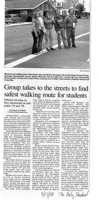
3 SAFE ROUTES TO SCHOOL TRAVEL PLAN MARION LOCAL SCHOOLS MARIA STEIN, OH SECTION 3: THE PUBLIC INPUT PROCESS MARION ON THE MOVE For our public input we utilized the following options: 1. Parent surveys 2. Interviews of key stakeholders 3. Soliciting student opinions 4. Incorporated school wellness policy objectives (attached Section 12) 5. Numerous public meetings conducted by the Marion Community Development Organization (MCDO) 6. Newspaper articles discussing Marion Local SRTS efforts (attached Section 12) SECTION 4: SCOPE Our school travel plan addresses the initial need of our K-8 elementary/middle school, under the guidelines of the grant application. But, in essence, the plan addresses the need(s) of the entire Marion Community. If we are able to accomplish the goals as outlined in the plan, it will provide safety and wellness benefits to everyone. The elementary/middle school is located in Maria Stein, which is the center of the Marion Community. Students from five other communities feed into the Marion Local School System (Chickasaw, Osgood, St. Sebastian, St. Rose and Cassella). The plan will serve the Marion Local K-8 elementary/middle school (597 students) but will also benefit the 9-12 Marion Local High School (335 students). (See maps included in the DGL Engineering Report, and the attached aerial map from Fanning Howey in Section 12.) 3 5/15/2009
4 SECTION 5: SCHOOL DEMOGRAPHICS SAFE ROUTES TO SCHOOL TRAVEL PLAN MARION LOCAL SCHOOLS MARIA STEIN, OH MARION ON THE MOVE Source: 4 5/15/2009
5 SAFE ROUTES TO SCHOOL TRAVEL PLAN MARION LOCAL SCHOOLS MARIA STEIN, OH MARION ON THE MOVE SECTION 6: CURRENT SCHOOL TRAVEL ENVIRONMENT Current travel modes and numbers: 597 students are enrolled at the elementary/middle school. 465 ride the bus, 10 walk, 5 ride bikes, and 117 are driven to school by family members. (All numbers are averages and dependent on the weather) Distance from school: 60 students live within walking distance (one mile or less) from the elementary/middle school. 185 students live within two miles. Number of Students in grades K-8: 597 Number of Students living within 1 mile of school: 60 Number of Students living within 2 miles of school: 185 Supports during student travel times: Students are welcomed to the elementary/middle school by administrators and teachers in the morning at the front door of the school (bus) and are ushered out at the end of the day. Those driving with parents to the school are dropped off at another door with teachers supervising the entrance and hallways. After school, students exit the same door as those using the bus (see below). Arrival/dismissal procedures: Students arrive at the school between 8:00 8:25 a.m. daily. There are three monitored entrances for students to enter the building each morning. The majority of the students arrives by school bus and is left off at one of two supervised entrances on the east side of the school building. Entrances are supervised by certified staff and/or building administrators. Bus drivers assist with the supervision as the students disembark from their buses. Almost weekly one or more of the buses are delayed in arrival, due to traffic congestion at the intersection of St. Rt. 119 and St. Rt Approximately 15% of the student body arrives in personal vehicles. Their parents or older siblings drop them off at two supervised entrances. One entrance is the same as used for the bus stops. The second is on the west side of school away from the flow of the bus zone. Departure is accomplished in the same manner as arrival, only in reverse form. Entrances are again supervised by certified or non-certified staff as well as building administrators. Students load the school buses under the supervision of the bus drivers at designated intervals of time. The youngest grades (K-2) depart the building at the 3:11 p.m. bell. The next grades (3-5) leave at 3:13 and the oldest grades (6-8) at 3:15. Students leaving in personal vehicles do so under the same time frame, with all vehicles exiting the parking lot ahead of the school buses. The number of students leaving at the end of the day is slightly less than arrivals due to after school events and athletic practices for junior high students. 5 5/15/2009
6 SAFE ROUTES TO SCHOOL TRAVEL PLAN MARION LOCAL SCHOOLS MARIA STEIN, OH MARION ON THE MOVE School travel policies: Marion Local has policies in place that deal with student transportation services (EEA); walkers and riders (EEAA); school bus scheduling and routing (EEAB). Teachers are in the hallways during dismissal. Dismissal times for buses are: K-2 students that ride first pickup at 3:11 p.m.; grades 3-5 dismiss students that ride the first pick-up at 3:13; grades 6-8 dismiss students that ride the first pick-up at 3:15. (next two pages) 6 5/15/2009
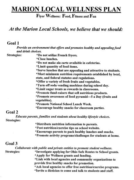
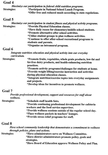
7 SAFE ROUTES TO SCHOOL TRAVEL PLAN MARION LOCAL SCHOOLS MARIA STEIN, OH MARION ON THE MOVE What Marion Local is already doing: Marion Local has a wellness program that has a goal of collaborating with public and private entities to promote overall student wellness. We also promote healthy lifestyles through food nutrition, our curriculum, and extra-curricular involvement. Teachers promote wellness with the projects they do in class. We have other goals that include: 1. Provide an environment that offers and promotes healthy lifestyle choices. 2. Educate parents, families and students about healthy lifestyle choices. 3. Maximize our participation in federal child nutrition programs. 4. Maximize our participation in student fitness and physical activity programs. 5. Integrate nutrition education and physical activity into our everyday curriculum; provide professional development, support, and resources for staff about wellness. 6. Have school community leadership that demonstrates a commitment to wellness through policies, plans, and action. 7. Provide a positive dining environment that encourages a pleasant eating experience. 8. Provide and promote social, noncompetitive fitness and activity opportunities 9. Use data to develop, structure, and support our Wellness Plan. (See Marion Local Wellness Plan, attached in Section 12) 7 5/15/2009
8 SAFE ROUTES TO SCHOOL TRAVEL PLAN MARION LOCAL SCHOOLS MARIA STEIN, OH MARION ON THE MOVE SECTION 7: BARRIERS TO ACTIVE TRANSPORTATION Please refer to Marion Local SRTS study submitted by DGL Engineering and approved by Rhonda Voisard of Sidney, OH ODOT in December SECTION 8: CREATING SOLUTIONS AND COUNTERMEASURES Please refer to Marion Local SRTS study submitted by DGL Engineering and approved by Rhonda Voisard of Sidney, OH ODOT in December SECTION 9: IMPROVEMENTS MAPPING Please refer to Marion Local SRTS study submitted by DGL Engineering and approved by Rhonda Voisard of Sidney, OH ODOT in December (DGL Engineering Study attached in Section 12) SECTION 10: THE ACTION PLAN The Marion Local SRTS team met on Monday February 2, 2009 to develop the attached action plan. The team evaluated all aspects of the DGL report and prioritized the action items listed in the following table. The team rated the projects based on the greatest safety impact, feasibility and likelihood of implementation with considerations given to the cost of each project. 8 5/15/2009
9 SAFE ROUTES TO SCHOOL TRAVEL PLAN MARION LOCAL SCHOOLS MARIA STEIN, OH MARION ON THE MOVE Strategy Type Engineering/ Enforcement Engineering Engineering Engineering/ Enforcement Engineering Engineering Engineering Evaluation/ Education Strategy Name Relocate Flasher Install Crosswalks Install Crosswalks Relocate Flasher Install Crosswalks Install Crosswalks Install Crosswalks SRTS Parent Survey Strategy Detail Relocate 20 mph flasher on west bound SR 119 to east of SR 119/716 intersection at a point 300' from school property line Install three (3) crosswalks and suggested crosswalk signs at SR 119/716 intersection. Install one (1) crosswalk and suggested crosswalk signs along SR 119 at primary southbound entrance to elementary school Relocate 20 mph flasher on north bound SR ' further south of school property line Install one (1) crosswalk and suggested crosswalk signs at south east corner of elementary building leading to football field area Install two (2) crosswalks and suggested crosswalk signs across driveway and SR 716 at north east corner of high school building Install two (2) crosswalks and suggested crosswalk signs across two driveways at south east corner of high school building Collect parent survey data and update in SRTS data base Time Frame August 2009 August 2009 August 2009 August 2009 August 2009 August 2009 August 2009 Fall 2008 Responsible Party ODOT Status Pending Est. Cost ODOT Pending $3,600 ODOT Pending $1,200 ODOT Pending ODOT Pending $1,200 ODOT Pending $2,400 ODOT Pending $2,400 M L Schools/ MCDO Complete N/A Funding Source ODOT/ SRTS Grant ODOT/ SRTS Grant ODOT/ SRTS Grant ODOT/ SRTS Grant ODOT/ SRTS Grant ODOT/ SRTS Grant ODOT/ SRTS Grant Marion Local Schools/ MCDO % of Students Affected 100% 100% 100% 50% 100% 100% 50% 100% 9 5/15/2009
10 SAFE ROUTES TO SCHOOL TRAVEL PLAN MARION LOCAL SCHOOLS MARIA STEIN, OH MARION ON THE MOVE Strategy Type Strategy Name Strategy Detail Time Frame Responsible Party Status Est. Cost Funding Source % of Students Affected 9 Encouragement/ Education Walk Across USA Conduct a Walking Across the USA campaign. April 2009 M L Schools Complete Marion Local Schools 100% Encouragement/ Education Encouragement/ Education Encouragement/ Education Evaluation/ Education Encouragement/ Education Engineering Kick Off INTL Walk to School Day LOGO Contest Student Tally Media Install Crosswalks Hold a Safe Routes to School kick - off celebration Conduct an International Walk To School day Conduct a "Marion on the Move" LOGO contest. Distribute prizes Track student arrival and departure on tally sheet. Update in SRTS data base Numerous SRTS related articles in local papers, Marion Local "Flyer Highlights", & Marion Community Development Organization (MCDO) newsletters. Install one (1) crosswalk and suggested crosswalk signs across SR 716 in general vicinity of 20 mph flasher October 2009 October 2009 October 2009 October 2008 On Going 6-12 months M L Schools M L Schools M L Schools M L Schools/ MCDO Various Pending $100 Pending $100 Pending $250 Complete On Going ODOT Pending $1,200 ODOT/Marion Local Schools ODOT/Marion Local Schools ODOT/Marion Local Schools Marion Local Schools/ MCDO Marion Local Schools/ MCDO ODOT/ SRTS Grant 100% 100% 100% 100% 100% 50% 10 5/15/2009
11 SAFE ROUTES TO SCHOOL TRAVEL PLAN MARION LOCAL SCHOOLS MARIA STEIN, OH MARION ON THE MOVE Strategy Type Strategy Name Strategy Detail Time Frame Responsible Party Status Est. Cost Funding Source % of Students Affected Engineering Engineering Engineering Enforcement Evaluation/ Enforcement Encouragement/ Education Encouragement/ Education Engineering Install Crosswalks Install Crosswalks Install Crosswalks Consolidate Speed Limit Evaluate Speed Patterns Walk Across USA INTL Walk to School Day New Walks Install one (1) crosswalk and suggested crosswalk signs across St Johns Road at Superior Drive in the Chapel Hill area Install one (1) crosswalk and suggested crosswalk signs at SR 119/St Johns Road intersection Install one (1) crosswalk and suggested crosswalk signs at SR 119/Rolfes Road intersection Consolidate current varying speed limits to one limit on SR 119 through entire length of the Maria Stein community Set up monitoring device to evaluate speed patterns through Maria Stein. Devise will be set up twice to determine speeds of east and west bound traffic Conduct a Walking Across the USA campaign. Conduct an International Walk To School day Install 3525 Sq Ft (881 Ft Lg) of sidewalk per engineering study on east side of SR months 6-12 months 6-12 months 6-18 months April 2009 April 2010 April months ODOT Pending $1,200 ODOT Pending $1,200 ODOT Pending $1,200 ODOT/ SRTS Grant ODOT/ SRTS Grant ODOT/ SRTS Grant 50% 50% 50% ODOT Pending TBD TBD 100% Mercer Cty Sheriff's Dept M L Schools M L Schools Complete Pending $100 Pending $100 ODOT Pending $21,150 Mercer County ODOT/Marion Local Schools ODOT/Marion Local Schools ODOT/ SRTS Grant 100% 100% 100% 50% 11 5/15/2009
12 SAFE ROUTES TO SCHOOL TRAVEL PLAN MARION LOCAL SCHOOLS MARIA STEIN, OH MARION ON THE MOVE 24 Strategy Type Engineering Strategy Name New Walks Strategy Detail Install 10,380 Sq Ft (2,595 Ft Lg) of sidewalk per engineering study on west side of Rolfes Road Time Frame months Responsible Party Status Est. Cost ODOT Pending $62,280 Funding Source ODOT/ SRTS Grant % of Students Affected 50% 12 5/15/2009
13
14 SECTION 12 SUPPORTING DOCUMENTS Documents supporting the Marion on the Move Safe Routes to School Travel Plan are attached on following pages.
15
16
17
18
19
20
21

22 SEE SEPARATELY ATTACHED DGL STUDY
23 SEE SEPARTELY ATTACHED AERIAL MAP FROM FANNING HOWEY SAFE ROUTES TO SCHOOL ENGINEERING STUDY MARION LOCAL SCHOOL DISTRICT VILLAGE OF MARIA STEIN OHIO DEPARTMENT OF TRANPORTATION DISTRICT SEVEN APPLICANT: MARION LOCAL SCHOOLS DATE: DECEMBER 12, 2008 PREPARED BY: DGL CONSULTING ENGINEERS 3455 Briarfield Blvd Maumee, Ohio 43537
24 TABLE OF CONTENTS PAGE EXECUTIVE SUMMARY... 1 EXISTING CONDITIONS IMPROVEMENT SUGGESTIONS COST ESTIMATES SUGGESTED IMPROVEMENTS MAP APPENDICES... A i

25 Safe Routes To School Engineering Study Marion Local Schools EXECUTIVE SUMMARY The purpose of this report was to conduct an engineering study as part of the Ohio Department of Transportation s Safe Routes to School program. The engineering study includes a walkability audit, analysis of accident records, identifying existing conditions and determining engineering countermeasures and solutions. EXISTING CONDITIONS Marion Local Schools are located in the Village of Maria Stein, Ohio at the intersection of SR 119 and SR 716. The school campus is located southwest of the intersection and includes an elementary, middle and high school on the same campus. The location map is shown in Figure 1. An aerial map is shown in Figure 2 that shows the populated areas within an approximate 1-mile radius. Figure 1 Location Map Marion Local Schools draws students from five communities including Chickasaw, Osgood, St. Sebastian, St. Rose and Cassella. There are also students that live south of Grand Lake St Mary s in the Celina School District that open enroll to Marion Local due to their location. 1

26 Safe Routes To School Engineering Study Marion Local Schools Only the students from the Maria Stein area live within the one-mile walking distance to the school. The majority of the eligible walkers live to the east and north of the school campus. Figure 2 Aerial map of population within 1-mile radius 2

27 Safe Routes To School Engineering Study Marion Local Schools The school campus is shown in Figure 3. Figure 3 School Campus Aerial The walking audit took place on September 15, 2008 with 14 attendees including two ODOT representatives. The sign-in sheet is included in this report. The group walked from the school, east on SR 119 to St Johns Road and returned to the SR 119/SR 716 intersection. The group then walked south to the southerly property of the school and walked through the school grounds to return to the elementary school. Several members of the group also observed the school departure operations. Buses line along the east side of the elementary building. This drive operates one way in the southerly direction. While the elementary and middle schools are loading onto the buses, the high school students are dismissed from the parking lot. The majority of the high school students drive to/from school. This action empties the high school lot before the buses depart. Elementary/middle school students that are picked up by parents use the SR 119 lot. The buses and high school students use drives on SR


28 Safe Routes To School Engineering Study Marion Local Schools The intersection of SR 119 and SR 716 was congested for about 30 minutes after school was dismissed. Observations at the intersection included grain trucks that stick out in the roadway and force cars to go around them, as many as 15 vehicles queued northbound and the crosswalk being blocked by drivers that have a hard time seeing down SR 119 to the west. Drivers that are impatient cut through the grain elevator site to get to eastbound SR 119. Younger drivers were observed accepting smaller gaps in traffic to get across SR 119 or to turn left. 4


 volumes on SR 119 were 2,600 in 2007 with")

29 Safe Routes To School Engineering Study Marion Local Schools Student walking from school were observed from both the high school and the elementary/middle school buildings. Some students did not use the designated crosswalks at the intersection. Crosswalks are not provided on the east approach. The intersection of SR 119 and SR 716 operates with SR 716 traffic (northbound and southbound) having a stop condition. Due to the nature of the agricultural, grain and animal businesses located nearby, truck traffic is significant on both roadways. Average Daily Traffic (ADT) volumes on SR 119 were 2,600 in 2007 with approximately 12 percent trucks. On SR 716, the ADT was approximately 1,500 in 2007 with 7 percent trucks. Those in attendance for the walking audit indicated that the intersection is congested in the morning and afternoon coinciding with school hours and on nights with home sporting events. 5


30 Safe Routes To School Engineering Study Marion Local Schools Sidewalks were found on both sides of SR 119 from the school property to approximately one half mile past St Johns Road. Sidewalks were not found on SR 716 north of SR 119, on Rolfs Road north or south of SR 119 or on St Johns Road south of SR 119. Sidewalks were found on the west side of St Johns Road from SR 119 to Marion Township Park and on the west side of SR 716 from the school property to approximately 0.4 miles south of the school property. These sidewalks were generally in good shape and were 4 feet in width. The roadways are not curbed and no curb ramps are provided. Near the intersection of SR 119 and SR 716, there are several parcels with sidewalk, drive, parking and shoulder areas adjacent to each other. These areas are confusing for the pedestrian and the drivers. The school campus provides sidewalks and painted walking areas in parking lots for most of the campus area. Bike racks are provided in two locations at the elementary/middle school building. 6

31 Safe Routes To School Engineering Study Marion Local Schools SIGNAL AND MULTI-WAY STOP ANALYSES ODOT placed a video recording vehicle at the intersection on October 14 from 12:00 pm to 6:00 pm and on October 15 from 6:00 am to 12:00 pm. The video was reviewed and turning movement counts were obtained along with pedestrian counts. Data was collected on an hourly basis. Traffic count data is included in the appendices. PC-Warrants software was used to compare the traffic volumes counted against the warrants for signalization. The intersection does not meet the requirements for a signalized intersection. Multi-way stop warrants were then checked for the intersection. The minimum requirements for a multi-way stop warrant were not met. Warrant software output in included in the appendices. ACCIDENT DATA Per the provided accident data spreadsheet, no pedestrian or biking accidents were reported for children of school age near Marion Local Schools during the study period of SUGGESTED IMPROVEMENTS HIGH PRIORITY-0 TO 12 MONTHS Upgraded school campus markings and signs Consider implementing marked crosswalks on all school drives. Crosswalk signs should also be provided. In the staff parking area between the elementary/middle school and the high school, the painted walking area should be continued as many students move between the buildings throughout the day. It is recommended that the school flasher signs located just west and south of the SR 119 and SR 716 intersection be relocated to 300 from the school property line. This will place the flashers on the approach side of the intersection (just north and just east) and will reduce traffic to 20 mph within the intersection during school flashing hours. Upgraded intersection markings and signs - Consider implementing marked crosswalks on west, north and south approaches at the SR 119/SR 716 intersection. Any installed crosswalks should meet current ODOT standards. The preferred crosswalk markings are ladder style. Crosswalk signs with the fluorescent yellow-green background should also be provided. Fluorescent yellow-green signs are more conspicuous than standard yellow signs, especially at dawn and dusk, as well as during inclement weather. As a result, drivers detect fluorescent yellow-green signs from greater distances, which enables drivers to respond to situations earlier (i.e., slowing down or yielding to a 7

32 Safe Routes To School Engineering Study Marion Local Schools pedestrian). By alerting drivers sooner that special caution is needed, fluorescent yellow-green signs significantly improve the safety of students who walk and bike to school. The preferred signs are yellow-green S1-1. The S1-1sign will be provided for advanced warning with the W16-9p AHEAD plaque and at the actual crosswalk with the W16-7 sloping down arrow plaque. SR 716 Crosswalk at School Property Consider implementing a new crosswalk on the south approach at the drive south of the stadium. This crosswalk would provide a marking crossing for students that live on the east side of SR 716. Proper crosswalk signage to be included. Sidewalk Delineation Consider painting the pedestrian walking area or edge lines delineating the pedestrian walking are where sidewalks abuts or is included in parking lots or adjacent to shoulders and other paved areas. MEDIUM PRIORITY-1 TO 3 YEARS Speed Limit Consolidation Speed limits along SR 119 range from 55 mph west of the school to 25 mph near the SR 119/SR 716 intersection to 45 mph east of the intersection, then back to 35 mph near St Johns Road and then back to 55 mph. A common speed limit should be considered for consistency and enforcement. 8
33 Safe Routes To School Engineering Study Marion Local Schools SR 119 Sidewalk and Crosswalks Consider installing sidewalk along the school property along SR 119 to the westerly school property line. A crosswalk should be considered within the school property frontage. SR 716 Sidewalk Consider installing sidewalk along the populated area east of SR 716 to at least the southerly school property line. As residential homes are constructed in this area, sidewalk should be added. St Johns Road Crosswalk Consider installing sidewalk crosswalk with appropriate signage for students living in the subdivision to cross St Johns Road. Rolfs Road Sidewalk Consider extending sidewalk from SR 119 to the north for residential areas. LEGISLATIVE Sidewalk Installation Marion Township should review subdivision plans submitted to Mercer County and request sidewalks in all subdivisions. ENFORCEMENT Speed Limit and School Zone Enforcement Law enforcement officers should be present and enforce all limits including the 20 mph school speed limit during the appropriate hours. EDUCATION Pedestrian and Bike Safety A program that instructs all aspects of pedestrian and bicycle safety should be considered for students. These can be accomplished with classroom activities, bike rodeos, safety town, walking clubs, etc. Media Support Local residents should be made aware of school zone safety rules through the use of media articles and/or a township newsletter. 9
34 Safe Routes To School Engineering Study Marion Local Schools COST ESTIMATES MARION LOCAL COUNTERMEASURE COST ESTIMATES Upgraded school campus markings and signs Crosswalks & Signage 8 Each $1, $9, Sidewalks 1520 SF $6.00 $9, $18, Upgraded intersection markings and signs Crosswalks & Signage 3 Each $1, $3, SR 716 Crosswalk at School Property Crosswalks & Signage 8 Each $1, $9, Sidewalk Delineation Sidewalk Delineation 1 Lump $5,000 $5,000 SR 119 Sidewalk and Crosswalks Walk, 4ft 1564 SF $6.00 $9, Crosswalks & Signage 2 Each $ $1, $10, SR 716 Sidewalk Walk, 4ft 3525 SF $6.00 $21, St Johns Road Crosswalk Crosswalks & Signage 1 Each $1, $1, Rolfs Road Sidewalk Walk, 4ft SF $6.00 $62, Total $131,
Wellington Exempted Village School District SAFE ROUTES TO SCHOOL TRAVEL PLAN January 2014
 Wellington Exempted Village School District SAFE ROUTES TO SCHOOL TRAVEL PLAN January 2014 OHIO SAFE ROUTES TO SCHOOL WELLINGTON EXEMPTED VILLAGE SCHOOL DISTRICT TRAVEL PLAN SECTION 1: WELLINGTON EXEMPTED
SAFE ROUTES TO SCHOOL
 SAFE ROUTES TO SCHOOL Forest Ridge Elementary School Existing Conditions and ACTION PLAN > Oak Creek - Franklin Joint School District Table of Contents CONTEXT Enrollment Boundaries
CITY OF OAK CREEK SAFE ROUTES TO SCHOOL ACTION PLAN. East Middle School
 CITY OF OAK CREEK SAFE ROUTES TO SCHOOL ACTION PLAN East Middle School CITY OF OAK CREEK SAFE ROUTES TO SCHOOL ACTION PLAN East Middle School Why Safe Routes to School? Safe Routes to School ( SRTS ) is
ARCADIA ELEMENTARY & MIDDLE SCHOOLS
 ARCADIA ELEMENTARY & MIDDLE SCHOOLS SAFE ROUTES TO SCHOOL TRAVEL August 2013 ARCADIA LOCAL SCHOOLS OHIO SAFE ROUTES TO SCHOOL SCHOOL TRAVEL Ohio Safe Routes to School Travel Plan Local Schools www.dot.state.oh.us/saferoutes
SECTION 1 - CONTACT INFORMATION
 SECTION 1 - CONTACT INFORMATION Please complete the information below. The person identified as the Project Contact Person will be the primary point of contact for Georgia DOT staff. Organization: (Please
2 Mark Twain Elementary School Report
 2 Mark Twain Elementary School Report Principal: Greg Kaatz Grades: K-2 Enrollment: 323 Address: 425 N. Church Street First bell: 8:10 a.m. Silverton, OR 97381 Last bell: 2:30 p.m. Free & Reduced Lunch:
3 Silverton High School Report
 3 Silverton High School Report Principal: Justin Lieuallen Grades: 9-12 Enrollment: 1,277 Address: 1456 Pine Street First bell: 7:55 a.m. Silverton, OR 97381 Last bell: 3:05 p.m. Free & Reduced Lunch:
July 5, Arthur R. Ware, Jr. Elementary School 2017 Safe Routes to School Walkabout Report
 July 5, 2017 Arthur R. Ware, Jr. Elementary School 2017 Safe Routes to School Walkabout Report 1 Walkabout Report Introduction On April 28, 2017, City, School, and SAWMPO staff met to conduct a Safe Routes
Introduction.
 2307-1.0. Introduction. Delaware s Safe Routes to School (SRTS) Program was established September 10, 2002 when Governor Ruth Ann Minner signed Senate Bill 353 of the 141st General Assembly of Delaware
Safe Routes to School Comprehensive Plan
 Safe Routes to School Comprehensive Plan City of Apple Valley Dakota County, MN May 2010 Prepared by: Project Background The Statewide Health Improvement Program (SHIP) aims to help Minnesotans live longer,
C/CAG. Sunnybrae Elementary School Walking and Bicycling Audit. San Mateo-Foster City School District JUNE 2013
 Sunnybrae Elementary School Walking and Bicycling Audit JUNE 2013 San Mateo-Foster City School District C/CAG City/County Association of Governments of San Mateo County SUNNYBRAE ELEMENTARY SCHOOL WALKING
LTAC: Katie Mencarini, Central & Hampton Roads streets and a fifteen minute debrief to discuss the findings. Participants walked along Mill Road
 Walkabout Summary On June 3, 2013, five participants met at Glen Allen Elementary School in Glen Allen, Virginia to take a closer look at the walking and biking network around the school. In addition to
S A F E R O U T E S T O S C H O O L H E R M A N TOW N S C H O O L S A N D P R O C TO R S C H O O L S P L A N A P P R OVA L S
 S A F E R O U T E S T O S C H O O L H E R M A N TOW N S C H O O L S A N D P R O C TO R S C H O O L S P L A N A P P R OVA L S WHAT IS SAFE ROUTES TO SCHOOL? In 1969, nearly 50% of children walked or rode
Sardis Elementary School Road Safety Plan. Produced by: Sardis Elementary School - Safer School Travel Team in cooperation with Safer City
 Sardis Elementary Road Safety Plan Produced by: Sardis Elementary - Safer Travel Team in cooperation with Safer City Plan completed in January 2016 1 Acknowledgements It takes commitment and community
Vallecito Elementary School. Travel Plan
 Vallecito Elementary School Travel Plan TABLE OF CONTENTS 1. PURPOSE... 1 1.1. SR2S PLANNING, IMPLEMENTATION AND MONITORING... 1 1.2. MARIN COUNTY MEASURE A... 1 2. VALLECITO ELEMENTARY SCHOOL PROFILE...
Arlington Public Schools Thomas Jefferson Site Evaluation Transportation Networks. Thomas Jefferson Working Group Meeting #6 November 10, 2014
 Arlington Public Schools Thomas Jefferson Site Evaluation Transportation Networks Thomas Jefferson Working Group Meeting #6 November 10, 2014 2 3 INTRODUCTION 4 Goal of our work: Identify and assess multi-modal
Drag and drop pic and stretch/crop to the limits of the blue rectangle (delete this text box) Maxey Elementary School
 Maxey Elementary School") Drag and drop pic and stretch/crop to the limits of the blue rectangle (delete this text box) Maxey Elementary School SCHOOL ROUTE PLAN For MAXEY ELEMENTARY SCHOOL LOCATION 33 ORANGE COUNTY Prepared for:
Drag and drop pic and stretch/crop to the limits of the blue rectangle (delete this text box) Maxey Elementary School SCHOOL ROUTE PLAN For MAXEY ELEMENTARY SCHOOL LOCATION 33 ORANGE COUNTY Prepared for:
SAFE ROUTES TO SCHOOL
 SAFE ROUTES TO SCHOOL Edgewood Elementary School Existing Conditions and ACTION PLAN > Oak Creek - Franklin Joint School District Table of Contents CONTEXT Enrollment Boundaries Enrollment
Safe Routes to School Travel Plan 2011 Reading-Fleming Intermediate School (RFIS)
") Safe Routes to School Travel Plan 0 Reading-Fleming Intermediate School (RFIS) Reading Fleming Intermediate School 50 Court Street Flemington, NJ 088 Grades: 5-6 Introduction Reading-Fleming Intermediate
Safe Routes to School Travel Plan 0 Reading-Fleming Intermediate School (RFIS) Reading Fleming Intermediate School 50 Court Street Flemington, NJ 088 Grades: 5-6 Introduction Reading-Fleming Intermediate
Bremen Elementary. SAFE ROUTES TO SCHOOL TRAVEL PLAN October 9, 2012
 Bremen Elementary SAFE ROUTES TO SCHOOL TRAVEL PLAN October 9, 2012 Introduction The purpose of the Bremen Elementary Safe Route to School (SRTS) Plan is to encourage school age children to travel to school
Lake Whitney Elementary School
 Lake Whitney Elementary School SCHOOL ROUTE PLAN For LAKE WHITNEY ELEMENTARY SCHOOL LOCATION 18 ORANGE COUNTY Prepared for: ORANGE COUNTY SCHOOL ASSESSMENT PROGRAM ORANGE COUNTY PUBLIC WORKS Traffic Engineering
Safe Routes to School Comprehensive Plan
 Safe Routes to School Comprehensive Plan City of Rosemount Dakota County, MN June 2010 Prepared by: Project Background The Statewide Health Improvement Program (SHIP) aims to help Minnesotans live longer,
Orange Center Elementary School
 Drag and drop pic and stretch/crop to the limits of the blue rectangle (delete this text box) Orange Center Elementary School Drag and drop pic and stretch/crop to the limits of the blue rectangle (delete
TRAFFIC IMPACT STUDY And A TRAFFIC SIGNAL WARRANT ANALYSIS FOR A SENIOR LIVING AND APARTMENT DEVELOPMENT
 TRAFFIC IMPACT STUDY And A TRAFFIC SIGNAL WARRANT ANALYSIS FOR A SENIOR LIVING AND APARTMENT DEVELOPMENT DEERFIELD TOWNSHIP, WARREN COUNTY, OHIO Nantucket Circle and Montgomery Road () Prepared for: ODLE
Hidden Oaks Elementary School
 Hidden Oaks Elementary School SCHOOL ROUTE PLAN For HIDDEN OAKS ELEMENTARY SCHOOL LOCATION 13 ORANGE COUNTY Prepared for: ORANGE COUNTY SCHOOL ASSESSMENT PROGRAM ORANGE COUNTY PUBLIC WORKS Traffic Engineering
Implementing the Three Es of School Zone Traffic Calming
 Implementing the Three Es of School Zone Traffic Calming Use this evaluation tool as a guide to analyze the specific safety needs of your school. SCHOOL PROFILE School Name: School District: Address: Phone
OCEAN DRIVE ELEMENTARY SCHOOL
 OCEAN DRIVE ELEMENTARY SCHOOL North Myrtle Beach, SC Safe Routes to School Travel Plan JANUARY 2017 SRTS Team Roster SRTS Team members represent key community stakeholders, share work of developing the
Safe Routes to School Action Plan Aberdeen, Idaho
 Background Aberdeen, Idaho is a largely agricultural community of nearly 2,000 people and is located in the southeast portion of the state on the western edge of American Falls Reservoir. The community
Bringing together community and health. Physical Activity and Nutrition Unit Office of Statewide Health Improvement Initiatives
 Bringing together community and health. Physical Activity and Nutrition Unit Office of Statewide Health Improvement Initiatives Physical Activity and Nutrition Unit Office of Statewide Health Improvement
Safe Routes to School Guide
 Safe Routes to School Guide Steps to Creating a Safe Routes to School Program Created February 2007 SafeRoutes National Center for Safe Routes to School This guide was developed by the Pedestrian and Bicycle
Village of Caldwell Safe Routes to School School Travel Plan Ohio Department of Transportation, District 10 May 31, 2012
 Village of Caldwell Safe Routes to School School Travel Plan Ohio Department of Transportation, District 10 May 31, 2012 Caldwell School Travel Plan (STP) Safe Routes to School Table of Contents Part 1:
Summary Report School Walking & Bicycling Audits. Mesa County Regional Transportation Planning Office
 Summary Report School Walking & Bicycling Audits Mesa County Regional Transportation Planning Office This page left blank intentionally WALKING & BICYCLING AUDIT SUMMARY 2 Executive Summary Background:
Windy Ridge Elementary School
 Windy Ridge Elementary School SCHOOL ROUTE PLAN For WINDY RIDGE ELEMENTARY SCHOOL LOCATION 54 ORANGE COUNTY Prepared for: ORANGE COUNTY SCHOOL ASSESSMENT PROGRAM ORANGE COUNTY PUBLIC WORKS Traffic Engineering
THORNVILLE-GLENFORD STP
 THORNVILLE-GLENFORD STP SAFE ROUTES TO SCHOOL TRAVEL PLAN September 2013 OHIO SAFE ROUTES TO SCHOOL SCHOOL TRAVEL PLAN SECTION 1: OUR SCHOOL/S 1A. Identify Target Schools School District School Name School
CHILLICOTHE CITY SCHOOLS. SAFE ROUTES TO SCHOOL TRAVEL PLANS for Allen, Mt. Logan, Tiffin & Worthington Elementary Schools January 2013
 CHILLICOTHE CITY SCHOOLS SAFE ROUTES TO SCHOOL TRAVEL PLANS for Allen, Mt. Logan, Tiffin & Worthington Elementary Schools January 2013 i Ohio s Safe Routes to School Travel Plan Template www.dot.state.oh.us/saferoutes
Walkabout Summary Report
 Walkabout Summary Report Introduction On September 3, 2014, stakeholders at Bessie Weller Elementary School (Bessie Weller ES) in Staunton, Virginia met to examine the walking and bicycling network around
Lawrence Safe Routes to School. Community Meeting January 14, 2015
 Lawrence Safe Routes to School Community Meeting January 14, 2015 Safe Routes to School The 6 E s Education Encouragement Enforcement Engineering Evaluation Equity What are the elements of a SRTS plan?
NORTH UNION LOCAL SCHOOLS
 NORTH UNION LOCAL SCHOOLS SAFE ROUTES TO SCHOOL TRAVEL PLAN November 2015 OHIO SAFE ROUTES TO SCHOOL SCHOOL TRAVEL PLAN SECTION 1: OUR SCHOOL(S) 1A. Identify Target Schools School District School Name
PEDESTRIAN ACTION PLAN
 ATTACHMENT 2 CITY OF SANTA MONICA PEDESTRIAN ACTION PLAN CITY OF SANTA MONICA PEDESTRIAN ACTION PLAN This page intentionally left blank EXECUTIVE SUMMARY CHAPTER 1 EXECUTIVE SUMMARY Setting the Stage
HALFF TRAFFIC MANAGEMENT PLAN. Richardson ISD Northwood Hills Elementary School Dallas, Texas. /? /4O/2o16
 30279 161966 TRAFFIC MANAGEMENT PLAN Richardson ISD Northwood Hills Elementary School August 30 2016 Exhibit 976B Planned Development District No. 976 Z156-311(OTH) Approved City Plan Commission October
Corporate. Report COUNCIL DATE: May 25, 1998 NO: R1500 REGULAR COUNCIL. TO: Mayor & Council DATE: April 27, 1998
 R1500 : Traffic Safety at 25 Avenue and 128 Street Intersection Corporate NO: R1500 Report COUNCIL DATE: May 25, 1998 REGULAR COUNCIL TO: Mayor & Council DATE: April 27, 1998 FROM: General Manager, Engineering
San Ramon Elementary School. Travel Plan
 San Ramon Elementary School Travel Plan TABLE OF CONTENTS 1. PURPOSE... 1 1.1. SR2S PLANNING, IMPLEMENTATION AND MONITORING... 1 1.2. MARIN COUNTY MEASURE A... 1 2. SAN RAMON ELEMENTARY SCHOOL PROFILE...
Chapter 3.9 Timbercrest Elementary School. Volusia County MPO. November 2008
 Chapter 3.9 Timbercrest Elementary School Deltona, FL Volusia County MPO November 2008 Volusia County MPO School Bicycle and Pedestrian Review Study, Phase 3B School Summary Timbercrest Elementary School
Windom Area Schools District #177 Safe Routes to School Plan Winfair Elementary & the Middle School January 2014
 Windom Area Schools District #177 Safe Routes to School Plan Winfair Elementary & the Middle School January 2014 Prepared by: Southwest Regional Development Commission 2401 Broadway Avenue, Suite 1 Slayton,
Pearl Sample Elementary & A.G. Richardson Elementary Walkabout Report
 Pearl Sample Elementary & A.G. Richardson Elementary Walkabout Report Introduction On December 14, 2017, stakeholders at Pearl Sample Elementary School and A.G. Richardson Elementary School in Culpeper,
PROSPECT ELEMENTARY GIRARD INTERMEDIATE GIRARD JUNIOR HIGH
 PROSPECT ELEMENTARY GIRARD INTERMEDIATE GIRARD JUNIOR HIGH SAFE ROUTES TO SCHOOL SCHOOL TRAVEL PLAN January 8, 2014 2 SECTION 1: OUR SCHOOLS School District School Name School Address Grades served Girard
Chapter 2. Bellingham Bicycle Master Plan Chapter 2: Policies and Actions
 Chapter 2 Bellingham Bicycle Master Plan Chapter 2: Policies and Actions Chapter 2: Policies and Actions The Bicycle Master Plan provides a road map for making bicycling in Bellingham a viable transportation
Hedgepeth Williams Middle School and Paul Robeson Elementary School Trenton, NJ. School Travel Plan
 Hedgepeth Williams Middle School and Paul Robeson Elementary School Trenton, NJ School Travel Plan Hedgepeth Williams Middle School Description: Hedgepeth-Williams Middle School is located at 301 Gladstone
About the Studio. Edward J. Bloustein School of Planning and Public Policy - Rutgers University
 About the Studio Edward J. Bloustein School of Planning and Public Policy - Rutgers University Purpose of studio: Help City of Bayonne apply for Safe Routes to School (SRTS) funding by producing a School
Meadow Woods Elementary School
 Drag and drop pic and stretch/crop to the limits of the blue rectangle (delete this text box) Meadow Woods Elementary School Drag and drop pic and stretch/crop to the limits of the blue rectangle (delete
Get Oregon kids. Walking, biking and rolling to school planning guide
 Get Oregon kids Walking, biking and rolling to school planning guide The Oregon Health Authority produced this guide with assistance from the Oregon Department of Education, Oregon Department of Transportation
SCHOOL ROUTE PLAN. For HUNTER S CREEK ELEMENTARY SCHOOL LOCATION 14 ORANGE COUNTY. Prepared for:
 SCHOOL ROUTE PLAN For HUNTER S CREEK ELEMENTARY SCHOOL LOCATION 14 ORANGE COUNTY Prepared for: ORANGE COUNTY SCHOOL ASSESSMENT PROGRAM ORANGE COUNTY PUBLIC WORKS Traffic Engineering Division 42 South John
Prioritizing Schools for Safe Routes to School Infrastructure Projects
 Prioritizing Schools for Safe Routes to School Infrastructure Projects Determining the most effective use of limited infrastructure funds is a challenging task. It is especially demanding for local transportation
Grandview Heights Safe Routes to School School Travel Plan Ohio Department of Transportation, District 6 February 23, 2012
 Grandview Heights Safe Routes to School School Travel Plan Ohio Department of Transportation, District 6 February 23, 2012 Grandview Heights School Travel Plan (STP) Safe Routes to School Table of Contents
AMHERST EXEMPTED VILLAGE SCHOOLS AND SAINT JOSEPH SCHOOL
 AMHERST EXEMPTED VILLAGE SCHOOLS AND SAINT JOSEPH SCHOOL SAFE ROUTES TO SCHOOL TRAVEL PLAN 12/11/18 DRAFT OHIO SAFE ROUTES TO SCHOOL SCHOOL TRAVEL PLAN Ohio s Safe Routes to School Travel Plan Template
Enhanced Walkabout Summary Report
 Enhanced Walkabout Summary Report Introduction On September 18, 2013, thirteen participants met at Galax Elementary School in Galax, Virginia to examine the walking and bicycling network around the elementary
BETHEL ROAD AND SEDGWICK ROAD CORRIDOR STUDY
 DRAFT PLAN City Council Meeting August 14, 2017 STUDY AREA Sedgwick Corridor State Route 160, principal arterial with Class 3 access management designation, commuter and freight route, connection to SR
Agenda. Overview PRINCE GEORGE S PLAZA METRO AREA PEDESTRIAN PLAN
 PRINCE GEORGE S PLAZA METRO AREA PEDESTRIAN PLAN May 28, 2008 Agenda Welcome and introductions Project overview and issue identification Planning context and strengths Design challenges and initial recommendations
ASHTABULA AREA SCHOOLS STP
 ASHTABULA AREA SCHOOLS STP SAFE ROUTES TO SCHOOL TRAVEL PLAN April 2013 OHIO SAFE ROUTES TO SCHOOL SCHOOL TRAVEL PLAN SECTION 1: OUR SCHOOL/S 1A. Identify Target Schools School District School Name School
Chapter 4.3 Enterprise Elementary. Volusia County MPO. March Page 7.0
 Chapter 4.3 Enterprise Elementary Enterprise, FL Volusia County MPO March 2008 Page 7.0 Volusia County MPO Bicycle and Pedestrian School Safety Review Study Introduction Enterprise Elementary School is
TRAFFIC MANAGEMENT PLAN
 292 84 140440 TRAFFIC MANAGEMENT PLAN The purpose of the Traffic Management Plan (TMP) is to have established procedures for traffic flow and circulation around the elementary school related to student
Traffic Impact Study. Westlake Elementary School Westlake, Ohio. TMS Engineers, Inc. June 5, 2017
 TMS Engineers, Inc. Traffic Impact Study Westlake Elementary School Westlake, Ohio June 5, 2017 Prepared for: Westlake City Schools - Board of Education 27200 Hilliard Boulevard Westlake, OH 44145 TRAFFIC
TRAFFIC ACTION PLAN. Laurie Meadows Neighborhood CITY OF SAN MATEO
 TRAFFIC ACTION PLAN Laurie Meadows Neighborhood CITY OF SAN MATEO Draft January 2017 Table of Contents Introduction... 2 The Traffic Forum Process... 5 Neighborhood Traffic Issues... 7 Neighborhood Recommendations
ADA TRANSITION PLAN 2013
 ADA TRANSITION PLAN 2013 TABLE OF CONTENTS Contents Introduction 1 Purpose 2 Identified Obstacles to the Public Right of Way 3 Criteria for Determining Impediments at Village Facilities 4 Removing Barriers
CHAIR AND MEMBERS CIVIC WORKS COMMITTEE MEETING ON APRIL 25, 2016
 TO: FROM: SUBJECT: CHAIR AND MEMBERS CIVIC WORKS COMMITTEE MEETING ON APRIL 25, 2016 JOHN BRAAM, P. ENG. MANAGING DIRECTOR, ENVIRONMENTAL & ENGINEERING SERVICES AND CITY ENGINEER SCHOOL ZONE SPEED LIMIT
Transportation Planning Division
 Transportation Planning Division Presentation Outline Study Tasks Recap of Previous Meetings Data Collected Focus Areas within Study Limits Design Principles Tool Box Recommended Concepts Schedule Moving
BEVERLY GARDENS ELEMENTARY SCHOOL TRAVEL PLAN
 BEVERLY GARDENS ELEMENTARY SCHOOL TRAVEL PLAN City of Riverside, Ohio Ohio Safe Routes to School Plan INDEX SECTION 1: TARGET SCHOOLS AND THE SAFE ROUTES TO SCHOOL TEAM SECTION 2: INTRODUCTION SECTION
Safe Routes to School Travel Plan 2011
 Safe Routes to School Travel Plan 2011 Barley Sheaf Elementary School Barley Sheaf School 80 Barley Sheaf Road Flemington, NJ 08822 Grades: K-4 Introduction Barley Sheaf School is a K-4 elementary school
National Safe Routes to School Program: Initial Results
 National Safe Routes to School Program: Initial Results Lauren Marchetti National Center for Safe Routes to School 9 th Annual New Partners for Smart Growth Thursday, February 4, 2010 Seattle, WA August
CURBSIDE ACTIVITY DESIGN
 5 CURBSIDE ACTIVITY DESIGN This chapter provides design guidance for separated bike lanes adjacent to curbside activities including parking, loading and bus stops. Typical configurations are presented
Acknowledgements. Mr. David Nicol 3/23/2012. Daniel Camacho, P.E. Highway Engineer Federal Highway Administration Puerto Rico Division
 Daniel Camacho, P.E. Highway Engineer Federal Highway Administration Puerto Rico Division Acknowledgements Mr. David Nicol Director, FHWA Office of Safety FHWA Office of Safety http://safety.fhwa.dot.gov/provencountermeasures/
Sunset Park Center for Accelerated Studies
 Sunset Park Center for Accelerated Studies The following are a simple list of advantages, disadvantages, and recommendations based on a community assessment. It is not intended to be a list of complete
Elkton Elementary School Walkabout Report
 Elkton Elementary School Walkabout Report Introduction On September 12, 2017, stakeholders at Elkton Elementary School in Elkton, Virginia met to examine the walking and bicycling networks around the school
BEXLEY CITY SCHOOL DISTRICT
 BEXLEY CITY SCHOOL DISTRICT SAFE ROUTES TO SCHOOL TRAVEL PLAN December 2012 OHIO SAFE ROUTES TO SCHOOL SCHOOL TRAVEL PLAN SECTION 1: OUR SCHOOLS 1A. Identify Target Schools School District School Name
Rim Rock Elementary School Walking and Biking Audit
 Rim Rock Elementary School Walking and Biking Audit September 29, 2016 Rim Rock Elementary School Audit for Walking and Biking September 29, 2016 Audit Team Members: Sam Atkins, City Engineer, City of
Chapter 3.3 Horizon Elementary School. Volusia County MPO. June 2009
 Chapter 3.3 Horizon Elementary School Port Orange, FL Volusia County MPO June 2009 Volusia County MPO School Bicycle and Pedestrian Review Study, Phase 3C School Summary Horizon Elementary School is located
AGENDA ITEM NO. 5b HCAOG TAC meeting of May 8, 2014
 Humboldt County Association of Governments Eureka, CA, 95501 AGENDA ITEM NO. 5b HCAOG TAC meeting of May 8, 2014 DATE: May 1, 2014 TO: HCAOG Technical Advisory Committee (TAC) FROM:, SUBJECT: Letters of
6.0 PEDESTRIAN AND BICYCLE FACILITIES 6.1 INTRODUCTION 6.2 BICYCLE DEMAND AND SUITABILITY Bicycle Demand
 6.0 PEDESTRIAN AND BICYCLE FACILITIES 6.1 INTRODUCTION Bicycle and pedestrian travel along and in the vicinity of the corridor is part of the vision of Somerset and Hunterdon counties and the integrated
ORANGE COUNTY TRAFFIC COMMITTEE. Intersection Control. Constituent. Deepthi Arabolu. Relocate Stop Sign
 ORANGE COUNTY TRAFFIC COMMITTEE SUPERVISORIAL DISTRICT: 3 SUBJECT: Intersection Control LOCATION: Browning Avenue at Rainbow Drive; North Tustin; TB 830-E3 INITIATED BY: INVESTIGATOR: REQUEST: Constituent
FREMONT CITY SCHOOLS STP
 FREMONT CITY SCHOOLS STP SAFE ROUTES TO SCHOOL TRAVEL PLAN February 2014 OHIO SAFE ROUTES TO SCHOOL SCHOOL TRAVEL PLAN SECTION 1: OUR SCHOOL(S) 1A. Identify Target Schools School District School Name School
Active Transportation Facility Glossary
 Active Transportation Facility Glossary This document defines different active transportation facilities and suggests appropriate corridor types. Click on a facility type to jump to its definition. Bike
Traffic Circulation & Pedestrian Safety Study
 Lyons Township High School North Campus La Grange, Illinois Parking Lot Vaughan Building N Main Building Prepared for: Prepared by: July 23, 2015 Contents List of Figures, iii 1. Introduction...1 2. Existing
Ward Elementary School
 Clark County School Walk Audits Prepared For: Audit Date: September 20, 2016 Final Report Date: December 2016 Ward Elementary School Prepared By: Prepared By: & Overview This report summarizes existing
SRTS Programs That Increase Walking and Bicycling to School
 Getting Results: SRTS Programs That Increase Walking and Bicycling to School SafeRoutes National Center for Safe Routes to School Communities initiate Safe Routes to School (SRTS) programs for a variety
MEMORANDUM. Date: 9/13/2016. Citywide Crosswalk Policy
 MEMORANDUM Date: 9/13/2016 Re: Citywide Crosswalk Policy Foreword Through the s Circulation Element and Complete Streets Policy, it is the City s goal to promote walking trips and provide safe facilities
Transportation Impact Study for Abington Terrace
 Transportation Impact Study for Abington Terrace Abington Township, Montgomery County, PA Sandy A. Koza, P.E., PTOE PA PE License Number PE059911 Prepared by McMahon Associates, Inc. 425 Commerce Drive,
CITY OF KASSON TRANSPORTATION ALTERNATIVES KASSON SAFE ROUTES TO SCHOOL
 ve ha 8t G B A Mantorville Ave N 240th Ave 16th St NE 11th Ave NE K-M HIGH SCHOOL SUNRISE TRAIL TO MANTORVILLE MNTH 57 SUNSET TRAIL TO MANTORVILLE NE PARK 16TH ST NE TRAIL K-M ELEMENTARY SCHOOL K-M MIDDLE
VILLAGE OF NILES TRAFFIC CALMING POLICY
 INTRODUCTION There is increasing interest across the country in developing new strategies to reduce the speed and amount of traffic in residential neighborhoods. Measurement of speeds, traffic volumes,
APPENDIX E Needs Assessment
 APPENDIX E Needs Assessment Active Transportation Needs Assessment Technical Background This appendix provides the technical background supporting the findings presented in Section 3 of the report. Developed
Abingdon Elementary School School Transportation Report
 Abingdon Elementary School School Transportation Report May 2015 Prepared for Arlington Public Schools by Toole Design Group, LLC 1 CONTENTS Executive Summary... 3 Introduction... 7 Existing Conditions
BMPO Area-Wide School Traffic Guidelines
 Area-Wide School Traffic Guidelines Rigby 26 o Blackfoot Prepared for: BONNEVILLE METROPOLITAN PLANNING ORGANIZATION IDAHO FALLS, IDAHO 15 CHS Consulting Group TABLE OF CONTENTS Introduction... 1 Choosing
1.0 EXECUTIVE SUMMARY
 1.0 EXECUTIVE SUMMARY The Active Transportation Plan is a guide to accomplish the Town s vision for developing a network of sidewalks, on-road bicycle facilities, and trails that allow for safe and convenient
Walk Friendly Communities Education and Encouragement Programs
 Walk Friendly Communities Programs Dan Gelinne Walk Friendly Communities Workshop Grandview, MO June 2015 Module Overview Topics Background and purpose What is the role of education and encouragement programs?
AGENDA REPORT. Issue: Discussion of potential improvements on Barnwell Road at Niblick Drive
 AGENDA REPORT To: From: By: Honorable Mayor and City Council Members Warren Hutmacher, City Manager Tom Black, Public Works Director Date: March 23, 2016 Agenda: March 28, 2016 WORK SESSION AGENDA: Barnwell
MEMORANDUM INTRODUCTION AREA DESCRIPTION. DATE: December 8, 2017
 7719 SOUTH MAIN STREET MIDVALE, UT 84047 P 801.307.3400 MEMORANDUM DATE: December 8, 2017 TO: FROM: SUBJECT: PROJECT NUMBER: 344-7517-003 PROJECT NAME: Keith Ludwig, P.E. Midvale City Lesley Burns, Midvale
Introduction Additional Safe Routes to School Resources Main Street Elementary School Survey Results Field Audit...
 Contents Introduction... 2 Additional Safe Routes to School Resources... 2... 3 Survey Results... 4 Field Audit... 6 Proposed Safe Routes to School Elements... 9 Typical Safe Routes to School Summary...
BICYCLE AND PEDESTRIAN SCHOOL SAFETY REVIEW STUDY BUDDY TAYLOR MIDDLE SCHOOL PALM COAST, FLAGLER COUNTY, FL
 BICYCLE AND PEDESTRIAN SCHOOL SAFETY REVIEW STUDY BUDDY TAYLOR MIDDLE SCHOOL PALM COAST, FLAGLER COUNTY, FL Assessment & Implementation Report June 2017 Bicycle and Pedestrian Safety Review This page is
DEPARTMENT OF ENVIRONMENTAL SERVICES. North Harrison Street (Lee Highway to Little Falls Road) Comparative Analysis. Prepared for:
 Comparative Analysis. Prepared for:") DEPARTMENT OF ENVIRONMENTAL SERVICES North Harrison Street (Lee Highway to Little Falls Road) Comparative Analysis Prepared for: Arlington County Department of Environmental Services 2100 Clarendon Boulevard,
DEPARTMENT OF ENVIRONMENTAL SERVICES North Harrison Street (Lee Highway to Little Falls Road) Comparative Analysis Prepared for: Arlington County Department of Environmental Services 2100 Clarendon Boulevard,
INDUSTRIAL BUILDING 1660 COMSTOCK ROAD CITY OF OTTAWA TRANSPORTATION OVERVIEW. Prepared for:
 INDUSTRIAL BUILDING 1660 COMSTOCK ROAD CITY OF OTTAWA TRANSPORTATION OVERVIEW Prepared for: Simluc Contractors Limited 2550 Blackwell Street, Ottawa K1B 5R1 October 18, 2013 113-584 Overview_1.doc D. J.
A collaboration between St. Mary School, Chardon Local Schools, and the City of Chardon 1/22/10
 A collaboration between St. Mary School, Chardon Local Schools, and the City of Chardon 1/22/10 SECTION 1: THE SAFE ROUTES TO SCHOOL TEAM Identified stakeholders for Safe Routes to School (SRTS) include