LESSONS LEARNED: ALTERNATIVE INTERSECTION AND INTERCHANGES
|
|
|
- Blanche Chapman
- 5 years ago
- Views:
Transcription
1 LESSONS LEARNED: ALTERNATIVE INTERSECTION AND INTERCHANGES CRAIG ELEY, P.E., CHOICE ONE ENGINEEING MARC GRAKE, P.E., ODOT DISTRICT 8 TRAFFIC OPERATIONS KRAIG SHREWSBERRY, P.E., PTOE, ODOT DISTRICT 6 TRAFFIC OPERATIONS


2 INTENDED AUDIENCE: LOCAL CITIES AND VILLAGES THAT MAY BE CONSIDERING HOW TO IMPROVE INTERSECTION OR ANY INTERCHANGE BUT HAVE LIMITATIONS OF: TIME TO GET IMPROVEMENT BUILT QUICKLY BUDGET RIGHT-OF-WAY

3 FOR ANY PROJECT, WHAT ARE WE TRYING TO FIX? THE TWO MAIN REASONS FOR ANY TYPE OF INTERSECTION OR INTERCHANGE PROJECT: RELIEVE CONGESTION IMPROVE SAFETY WHILE KEEPING COSTS LOW AND WITH THE FEWEST IMPACTS.

4 HOW DO WE RELIEVE CONGESTION? STANDARD SOLUTIONS: ADD MORE PAVEMENT TO INCREASE CAPACITY: FOR INTERSECTIONS AND INTERCHANGES, MORE TRAFFIC WILL BE ABLE TO GET THRU THE INTERSECTION BY WIDENING TO ADD MORE TURN LANES/THRU LANES. POTENTIAL DRAWBACKS: EXPENSIVE TO ADD MORE PAVEMENT. MAY HAVE TO WIDEN BRIDGES. ADDITIONAL TIME AND MONEY TO PURCHASE RIGHT OF WAY. TRAFFIC IS ALWAYS INCREASING, SO SIMPLY JUST CAN T KEEP WIDENING AND WIDENING. CAN BE A LENGTHY PROCESS.


5 HOW DO WE IMPROVE SAFETY? STANDARD SOLUTIONS: REDUCE BACKUPS BY ADDING MORE LANES. IMPLEMENT PROTECTED ONLY MOVEMENTS. BUILD INTERCHANGES TO SEPARATE TRAFFIC. POTENTIAL DRAWBACKS: DOESN T REDUCE THE NUMBER OF CONFLICT POINTS AT AN INTERSECTION. RESTRICTION OF MOVEMENTS DOES IMPROVE SAFETY BUT WILL DECREASE TRAFFIC FLOW. GREAT EXPENSE OF TIME, MONEY, AND RIGHT-OF-WAY.
6 WHY ARE WE CONSIDERING ALTERNATIVE TREATMENTS NOW? STANDARD PRACTICES OR TREATMENTS CAN BE: EXPENSIVE LENGTHY PROCESS RIGHT-OF-WAY IMPACTS: ACQUIRING PROPERTY ADDS TIME AND MONEY TO THE PROJECT. IMPROVEMENTS CAN COUNTERACT EACH OTHER: IMPROVEMENT IN SAFETY MAY MEAN SACRIFICING TRAFFIC FLOW, SO WHAT DOES THE PUBLIC SEE? SIMPLY CAN T CONTINUE TO KEEP WIDENING AND BUILDING BRIDGES.
7 SO HOW DO WE GET MORE VEHICLES SAFELY THRU AN INTERSECTION? HAVE TO START THINKING OUTSIDE THE BOX WE KNOW THAT REDUCING THE NUMBER OF SIGNAL PHASES AT AN INTERSECTION WILL PROVIDE MORE GREEN TIME TO THE REMAINING PHASES: (EACH MOVEMENT GETS THEIR SLICE OF THE PIE FOR GREEN TIME)
 CONFLICTS, SO REDUCING THIS NUMBER OF CONFLICT POINTS WILL IMPROVE SAFETY.")
8 SO HOW DO WE GET MORE VEHICLES SAFELY THRU AN INTERSECTION? A STANDARD INTERSECTION HAS 32 CONFLICT POINTS WITH 16 CROSSING (LEFT TURN) CONFLICTS, SO REDUCING THIS NUMBER OF CONFLICT POINTS WILL IMPROVE SAFETY. SO REDUCING OR ELIMINATING LEFT TURN AND CROSSING MOVEMENTS SHOULD MAKE A SIGNIFICANT REDUCTION IN SAFETY. REDUCE THE NUMBER OF COVENTIONAL INTERSECTIONS-SIMPLY SAID, BUT HARD TO IMPLEMENT.
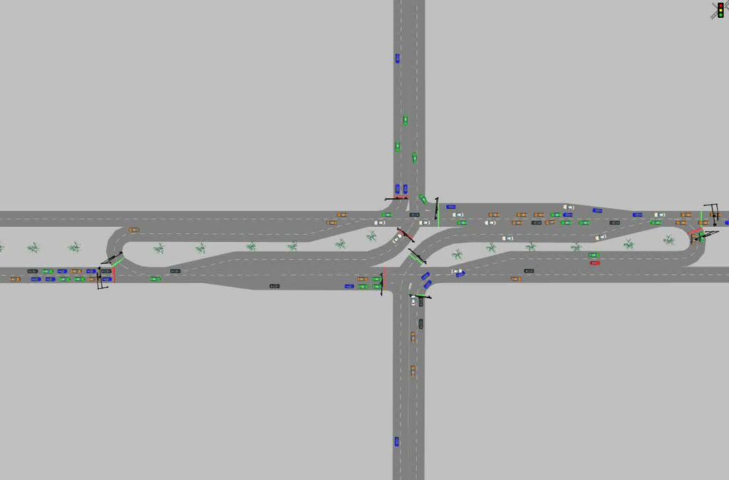
9 3 PROJECTS THAT USED ALTERNATIVE TREATMENTS PARTIAL CONTINUOUS FLOW INTERSECTION (PARTIAL CFI.) SR AUSTIN BLVD IN MONTGOMERY COUNTY, DISTRICT 7. SUPERSTREET INTERSECTION. SR 4 HAMILTON-MASON, TYLERSVILLE, AND SYMMES ROADS IN BUTLER COUNTY IN DISTRICT 8. SINGLE POINT URBAN INTERCHAGE (SPUI.) SUNBURY ROAD IN FRANKLIN COUNTY, DISTRICT 6.


 SR 741 &")

10 OUTLINE Continuous Flow Intersection Austin Boulevard & SR 741 Montgomery County, Ohio Ohio Dep t of Transportation District 7 General Overview of Continuous Flow Intersection (CFI) SR 741 & Austin Blvd Design and Operation Planning and Construction Lessons Learned / Questions 10
. Objective is to reduce delay and increase capacity.")
11 CONTINUOUS FLOW INTERSECTION Continuous Flow Intersection Austin Boulevard & SR 741 Montgomery County, Ohio Ohio Dep t of Transportation District 7 Courtesy FHWA FHWA defines this type of intersection as a Displaced Left Turn Intersection (DLT). Objective is to reduce delay and increase capacity. Left turn movements occur in advance of the main CFI traffic signal at advance traffic signals placed approximately 300 to 400 feet upstream of intersection. 11 CFIs have been shown to increase capacity by 60% compared to similar conventional intersections (1996 Traffic Control Systems Handbook)
12 CFI ADVANTAGES AND DISADVANTAGES Continuous Flow Intersection Austin Boulevard & SR 741 Montgomery County, Ohio Ohio Dep t of Transportation District 7 Courtesy FHWA Advantages Shorter delay and travel times Double left turn = 82.5 sec CFI = 27.4 sec Separate left turns from through traffic Improved capacity Disadvantages Adjacent Property Impacts (driveways, right-of-way, etc.) Signal Maintenance Pedestrian Accommodations 12 Driver Familiarity
13 DRIVER SAFETY Continuous Flow Intersection Austin Boulevard & SR 741 Montgomery County, Ohio Ohio Dep t of Transportation District 7 Courtesy FHWA CFIs have fewer conflict points than conventional intersections Angled conflict points are also fewer in CFIs Therefore when collisions do occur they tend to be less significant and damaging. 13

14 CONFLICT POINTS Courtesy FHWA Continuous Flow Intersection Austin Boulevard & SR 741 Montgomery County, Ohio Ohio Dep t of Transportation District 7 Traditional Intersection 32 conflict points 16 angle conflict points Continuous Flow Intersection 30 conflict points 14 angle conflict points 14

15 PEDESTRIAN MOVEMENTS AND SAFETY Continuous Flow Intersection Austin Boulevard & SR 741 Montgomery County, Ohio Ohio Dep t of Transportation District 7 15 Courtesy FHWA Crossing pattern similar to traditional intersection, but improvements should be made Pedestrian refuges between lanes can increase safety and minimize vehicle delay Accurate signing to guide pedestrians to their destination

16 ADVANCE LEFT TURN MOVEMENT Continuous Flow Intersection Austin Boulevard & SR 741 Montgomery County, Ohio Ohio Dep t of Transportation District 7 Courtesy FHWA 16

17 ADVANCE LEFT TURN MOVEMENT Continuous Flow Intersection Austin Boulevard & SR 741 Montgomery County, Ohio Ohio Dep t of Transportation District 7 Courtesy FHWA 17 Advance Left Turn Distance Ft
18 TWO-LEGGED CFI EXAMPLE Continuous Flow Intersection Austin Boulevard & SR 741 Montgomery County, Ohio Ohio Dep t of Transportation District 7 Courtesy FHWA Advance CFI Traffic Signal Center CFI Traffic Signal Advance CFI Traffic Signal 18
 493-3314, joe.")
19 FOUR-LEGGED CFI EXAMPLE Continuous Flow Intersection Austin Boulevard & SR 741 Montgomery County, Ohio Ohio Dep t of Transportation District 7 Courtesy FHWA 19 Source: FHWA Publication No.: FHWA-HRT , FHWA Contact: Joe Bared, HRDS-05, (202) , joe.bared@dot.gov

20 P1 P6 P2 P5 P3 P8 P4 P7 TWO-LEGGED CFI CENTER TRAFFIC SIGNAL Continuous Flow Intersection Austin Boulevard & SR 741 Montgomery County, Ohio Ohio Dep t of Transportation District 7 P1 P2 P3 P4 P5 P6 P7 P8 20

21 AUSTIN BOULEVARD & STATE ROUTE 741 LOCATION Continuous Flow Intersection Austin Boulevard & SR 741 Montgomery County, Ohio Ohio Dep t of Transportation District 7 Courtesy FHWA 21 Miami Township, Montgomery County, Ohio Opened fall 2010


22 AUSTIN BOULEVARD & STATE ROUTE 741 LAYOUT Continuous Flow Intersection Austin Boulevard & SR 741 Montgomery County, Ohio Ohio Dep t of Transportation District 7 Courtesy FHWA 22
23 WHY SELECT A CFI? Continuous Flow Intersection Austin Boulevard & SR 741 Montgomery County, Ohio Ohio Dep t of Transportation District 7 23 Austin Boulevard at SR 741, PM Peak Hour, Design Year 2035 Current Geometry (No-Build) Overall Average Delay: seconds Level of Service: F Eastbound/Westbound Travel Time: 3.3/1.6 minutes Current Geometry with Double Lefts, All Approaches Overall Average Delay: 65.3 seconds Level of Service: E Eastbound/Westbound Travel Time: 1.5/1.5 minutes Two-Legged CFI on Austin Boulevard (E/W) Overall Average Delay: 27.5 seconds Level of Service: C Eastbound/Westbound Travel Time: 1.3/1.6 minutes
24 PHASING DIAGRAM Photo taken by jyoh Continuous Flow Intersection Austin Boulevard & SR 741 Montgomery County, Ohio Ohio Dep t of Transportation District 7 24


 16 phases 15 overlaps")
25 25 Photo taken by jyoh OPERATION HIGHLIGHTS Continuous Flow Intersection Austin Boulevard & SR 741 Montgomery County, Ohio Ohio Dep t of Transportation District 7 The CFI operates utilizing: Three separate signalized locations consisting of: 34 traffic signal heads 20 pedestrian signal heads 16 Iteris Versicam video detection cameras with Edge Connect module for remote monitoring 6 single mast arm signal support poles 2 double mast arm signal support poles All controlled by: 2070 Siemens controller using Eagle Traffic software (First installation east of the Mississippi River) 16 phases 15 overlaps Photo taken by jyoh

26 CRASH DATA BEFORE CFI Continuous Flow Intersection Austin Boulevard & SR 741 Montgomery County, Ohio Ohio Dep t of Transportation District 7 26

27 CRASH DATA AFTER CFI Continuous Flow Intersection Austin Boulevard & SR 741 Montgomery County, Ohio Ohio Dep t of Transportation District 7 27

28 MOST RECENT CRASH DATA AFTER CFI Crashes Total Crashes = 100 Rear End = 71 Angle/Left Turn =15 SideSwipe passing = 8


29 OPENING DAY CONDITIONS Continuous Flow Intersection Austin Boulevard & SR 741 Montgomery County, Ohio Ohio Dep t of Transportation District 7 Photo taken by jyoh Delay and Level of Service Northbound Left Turn 92.6s / F (AM Peak) Eastbound Right Turn 146.6s / F (PM Peak) Public response 29
30 TRAFFIC VOLUMES Photo taken by jyoh Continuous Flow Intersection Austin Boulevard & SR 741 Montgomery County, Ohio Ohio Dep t of Transportation District 7 AM / PM Peak Hours Total Intersection Volume Source Year AM Peak PM Peak Projected IJS Traffic Count
31 Photo taken by jyoh Continuous Flow Intersection Austin Boulevard & SR 741 Montgomery County, Ohio Ohio Dep t of of Transportation Transportation District 7 District 7 AM / PM Peak Hours Selected Movements Source Year NB Left Turn EB Right Turn Projected IJS (AM) Projected IJS (PM) Traffic Count (AM) (687) 318 (376) Traffic Count (PM) (496) 649 (763) 31


32 PLANNING HIGHLIGHTS Continuous Flow Intersection Austin Boulevard & SR 741 Montgomery County, Ohio Ohio Dep t of Transportation District 7 Photo courtesy of LJB Eng. 32 P & N Access to regional area Congestion relief / adjoining interchange Economic Development Project CFI New Interchange on I-75 Not Fixing existing Problem Using traffic projections / design OSIP Imagery N


33 Construction Awarded Feb Completion Aug Photo courtesy of D-7 PIO Continuous Flow Intersection Austin Boulevard & SR 741 Montgomery County, Ohio Ohio Dep t of Transportation District 7 Consultants: Prime LJB Inc. Sub (Design of CFI) ABMB Engineers Inc. Several other consulting firms involved in planning & design Contractors: Prime John R Jurgenson Company Sub Contractors Traffic Signals Bansal Construction Traffic Signs M P Dory Co. Over 20 sub-contractors in total 33 Bid Information Eight bids in total Range between 22 million and 27.6 million Awarded bid= John R Jurgenson Company $22,005,676.51
 will include: 500,000 sq. ft. retail, restaurants, entertainment 500,000 sq. ft. professional office 100,000 sq.")

34 ECONOMIC IMPACT: AUSTIN LANDING Continuous Flow Intersection Austin Boulevard & SR 741 Montgomery County, Ohio Ohio Dep t of Transportation District 7 Photo courtesy of LJB Eng. 34 Phase 1 (NE Tract) will include: 500,000 sq. ft. retail, restaurants, entertainment 500,000 sq. ft. professional office 100,000 sq. ft. hospitality 200+ residential units Development Status: First 4-story office building complete & occupied Teradata Corp. has moved into its own 2-story building 87,000 sq. ft. Kohls opened in September room Hilton Garden Inn Kroger Photo from austinlanding.com

35 DEVELOPMENT Continuous Flow Intersection Austin Boulevard & SR 741 Montgomery County, Ohio Ohio Dep t of Transportation District 7 Photo courtesy of LJB Eng. 35


36 LESSONS LEARNED Access Management Plan is essential Economic Development (Known/ Unknown) : Future land use plan 20 year traffic-models / Adjoining project effects Public perception (not fixing a known problem) Increase size of signs 36 Ongoing studies: Actual Impacts vs. Projected


37 PROPOSED CHANGES Continuous Flow Intersection Austin Boulevard & SR 741 Montgomery County, Ohio Ohio Dep t of Transportation District 7 Photo taken by jyoh Sale Date July 2016 Est. Construction End Date June
38 SR 4 BYPASS SUPERSTREETS SUPERSTREET INTERSECTIONS ALLOW FULL MOVMENTS (LEFT, THRU, AND RIGHT TURNS) ON THE MAJOR STREET. TRAFFIC ON THE SIDE STREETS AT THE MAIN INTERSECTION ARE ONLY ALLOWED TO TURN RIGHT ONTO THE MAJOR STREET. PREVIOUS THRU OR LEFT TURN MOVEMENTS FROM THE SIDE STREETS ARE NOW MADE BY MAKING A U-TURN MOVEMENT AT A SIGNALIZED INTERSECTION OR LOON APPROXIMATELY 1000 FEET FROM THE MAIN INTERSECTION.

39 SR 4 BYPASS SUPERSTREETS


40 SR 4 BYPASS SUPERSTREETS
41


42 SR 4 BYPASS SUPERSTREETS How do we get from here To this?
43 SR 4 BYPASS SUPERSTREETS 1. ISSUES: 1. THE BYPASS WAS A HIGH SPEED 2 LANE HIGHWAY WITH AVERAGE DAILY TRAFFIC (ADT) VOLUMES OF 20,000-30,000 AS A HIGH COMMUTER ROUTE. 2. HEAVY SIDE STREET TRAFFIC AS WELL FROM SYMMES RD, TYLERSVILLE RD, AND HAMILTON-MASON RD. 3. HIGH NUMBER OF ACCIDENTS OCCURING ALONG THE BYPASS AND AT THE INTERSECTIONS. 4. TYPICALLY CYCLE LENGTHS OF SECONDS, WHICH IS VERY HIGH FOR A CONVENTIONAL INTERSECTION. RULE OF THUMB: LONGER CYCLE LENGTHS=LONGER QUEUES. 5. LONGER QUEUES ON A HIGH SPEED ROADWAY MEANS POTENTIAL FOR SEVERE READ- END ACCIDENTS.


44 SR 4 BYPASS SUPERSTREETS PREVIOUS SAFETY CONDITIONS:
45 SR 4 BYPASS SUPERSTREET SOLUTIONS? CONVENTIONAL CONCEPTS: SIMPLY WIDENING TO ADD MORE THROUGH LANES AND TURN LANES DOESN T RESOLVE THE POTENTIAL FOR ANGLE AND LEFT TURN CRASHES ON A HIGHSPEED ROADWAY. (IMAGINE SR 32 AT GLEN ESTE-WITHAMSVILLE RD.) CONSTRUCTING INTERCHANGES WOULD TAKE SEVERAL YEARS OF PLANNING AND CONSTRUCTION, CONSIDERABLE RIGHT-OF-WAY ACQUISTION, AND A COST OF TENS OF MILLIIONS OF DOLLARS PER INTERCHANGE.
46 SR 4 BYPASS SUPERSTREET ALERNATIVE SOLUTION: THE BYPASS WAS WIDENING FROM 2 LANES TO 4 AND 6 LANE SECTIONS FROM SYMMES RD TO SR 129, WHICH WAS NECESSARY IN ANY OF THE PROJECTS. 3 SUPERSTREET INTERSECTIONS WERE CONSTRUCTED AT SYMMES RD, TYLERSVILLE RD, AND HAMILTON-MASON RD TO INCREASE CAPACITY (REDUCES QUEUES) AND REDUCE THE NUMBER OF CONFLICT POINTS (REDUCES SEVERE CONFLICTS). TOTAL OF 3 PROJECTS TO WIDEN 3.25 MILES OF HIGHWAY AND CONSTRUCT THE SUPERSTREETS WAS NEARLY $22.5 MILLION. CONSTRCUTION OF 3 INTERCHANGES WOULD HAVE ADDED TENS OF MILLIONS AND REQUIRED MORE RIGHT-OF-WAY ON THE SIDE STREETS INCLUDING TOTAL TAKES.
47 SR 4 BYPASS SUPERSTREET IMPROVED SAFETY: REDUCED NUMBER OF CONFLICT POINT: 32 CONFLICT POINTS (16 CROSSING) 14 CONFLICT POINTS (2 CROSSING)

48 LESSONS LEARNED DESIGN: SUPERSTREETS AREN T IDEAL CANDIDATES FOR LOCATIONS WITH HIGH PEDESTRIAN USAGE. NO PEDS AT HAMILTON-MASON RD, SO COMPLEX OR UNUSUAL PED CROSSINGS HAVE BEEN AVOIDED. ILLUSTRATED CROSSING PATH:
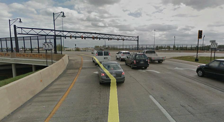
49 LESSONS LEARNED DESIGN: YOU WON T BE ABLE TO ANTICIPATE AND AVOID ALL POTENTIAL HICCUPS, SO EXPECT TO MAKE CHANGES AFTER OPENED TO TRAFFIC. THERE WILL BE TWEAKS TO THE TRAFFIC CONTROL: ISSUE OF LEFT TURN ON RED BETWEEN TWO ONE-WAY STREETS ALLOWED PER THE OHIO REVISED CODE, BUT SIGNED NOW TURN ON RED AT LOON INTERSECTIONS. PROHIBITED DUE TO HIGH-SPEED CONFLICTS. ADDED PAVEMENT MARKINGS TO IDENTIFY U-TURN AND RIGHT TURN ONLY LANES. VIDEO CAMERA RADAR DETECTION HAD TO BE RAISED TO DETECT FURTHER DOWN THE U- TURN LANES- SHOULD HAVE USED STANDARD LOOP DETECTORS.
50 LESSONS LEARNED DESIGN: CAREFULLY ON WHAT YOU PROMISE TO THE PUBLIC. ODOT MADE AN ENVIRONMENTAL COMMENT THAT THE LEFT TURN TRAFFIC ON HAMILTON-MASON WOULD GET A GREEN WHEN THEY ARRIVED AT THE LOON INTERSECTION. WHILE WE TIMED THAT THE AMOUNT OF TIME TO TURN RIGHT, MAKE A U TURN, AND RETURN TO THE MAIN INTERSECTION IS THE SAME AS THE TYPICAL WAIT IT USED TO MAKE A LEFT AT THE OLD INTERSECTION-PROMISE MET, BUT IT DOESN T MAKE IT DIFFICULT TO COORDINATE TRAFFIC TRAVELLING STRAIGHT THRU ON THE BYPASS. HOW LONG DO WE KEEP THIS COMMITMENT IF IT S A THE SACFRICE OF A LONGER VOLUME OF TRAFFIC MAKING MORE STOPS.
51 LESSONS LEARNED DESIGN: NUMBER OF SIGNALIZED INTERSECTIONS: TRY TO CREATE SIGNALIZED INTERSECTIONS THAT USE YOUR STANDARD CABINETS AND CONTROLLERS AND THAT CAN BE MAINTAINED EASILY WITH MAINTENANCE CREWS. CONSIDERED ONE CONTROLLER TO OPERATE ALL THREE INTERSECTIONS, BUT SETUP WOULD BE COMPLEX FOR SIGNAL ELECTRICIANS. DECIDED ON 3 CONTROLLERS 1 PER INTERSECTION USING STANDARD EQUIPMENT AND EASY TO MAINTAIN. IN HIND SIGHT: SHOULD HAVE USED 4 CONTROLLERS AND CABINETS-PER LOON AND 2 AT THE MAIN INTERSECTION. VASTLY DIFFERENT THINKING THAT EACH DIRECTION OF BYPASS CAN BE TIMED INDEPENDENTLY. MAYBE A FUTURE CHANGE???
52
53 LESSONS LEARNED CONSTRUCTION: FIRST IMPRESSIONS ARE MOST IMPORTANT: MAKE SURE THAT THE SIGNALS ARE 100% OPERATIONAL INCLUDING DETECTION AND SIGNAL TIMING AT THE TIME OF TURN ON! COMPLAINTS WILL START COMING IN!

54 LESSONS LEARNED MAINTENANCE: 3 SIGNALIZAED INTERSECTIONS PER SUPERSTREET TO ADD TO MAINTENANCE PROGRAM. AT LEAST 4 OVERHEAD CANTILEVER SIGN SUPPORTS TO ADD TO MAINTENANCE PROGRAM. CENTER INTERSECTION HAS A LARGE TRUSS SIGNAL SUPPORT TO MAINTAIN AS WELL. HOW TO MAINTAIN AND POSSIBLY REPLACE A SUPPORT OVER 200 FEET LONG???
55 LESSONS LEARNED TYPICAL CUSTOMER FEEDBACK: WHY DO WE HAVE TO STOP AT THE LOON INTERSECTION WHEN THERE ARE NO CARS MAKING U-TURNS. RESULT OF VIDEO DETECTION-SOON TO BE REPLACED WITH RADAR. WHEN TRAVELING STRAIGHT THRU THE LOON AND THE MAIN INTERSECTION, WHY DO I GET STOPPED. A PRODUCT OF ENVIRONMENTAL COMMITMENT TO COORDINATE THE RIGHT TURN FROM SIDE STREET TO GET A GREEN AT THE U-TURN. TWO COMPETING STRATEGIES. HARD TO BALANCE AND TO EXPLAIN! WHY CAN T I TRAVEL THROUGH SYMMES, TYLERSVILLE, AND HAMILTON-MASON RD WITHOUT STOPPING? PRODUCT OF SIGNAL SPACING OF 1.1 AND 1.3 MILES, WHICH IS HARD TO KEEP PLATOON TOGETHER AND COORDINATE FROM SIGNAL TO SIGNAL.
56 WOULD WE DO IT ALL OVER AGAIN? IMPROVED SAFETY. DEFINITELY! 257 TOTAL ACCIDENTS IN 3 YEARS PRIOR TO SUPERSTREETS, BUT 236 IN 3 YEARS SINCE THEY OPENED TO TRAFFIC. PROPERTY DAMAGE ONLY CRASHES-STAYED THE SAME. 20% REDUCTION IN INJURY CRASHES AND REAR-END CRASHES. NO FATALS. MOVING A HIGH VOLUME OF TRAFFIC. PROBABLY WILL STILL BE WAITING ON THE CONSTRUCTION OF INTERCHANGES.


57 SR-161 & SUNBURY ROAD SPUI


58 SR-161 & SUNBURY ROAD SPUI


59 SR-161 & SUNBURY ROAD SPUI CURRENT DECEMBER 2004
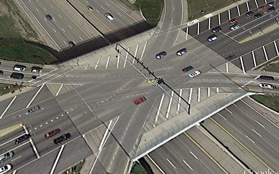
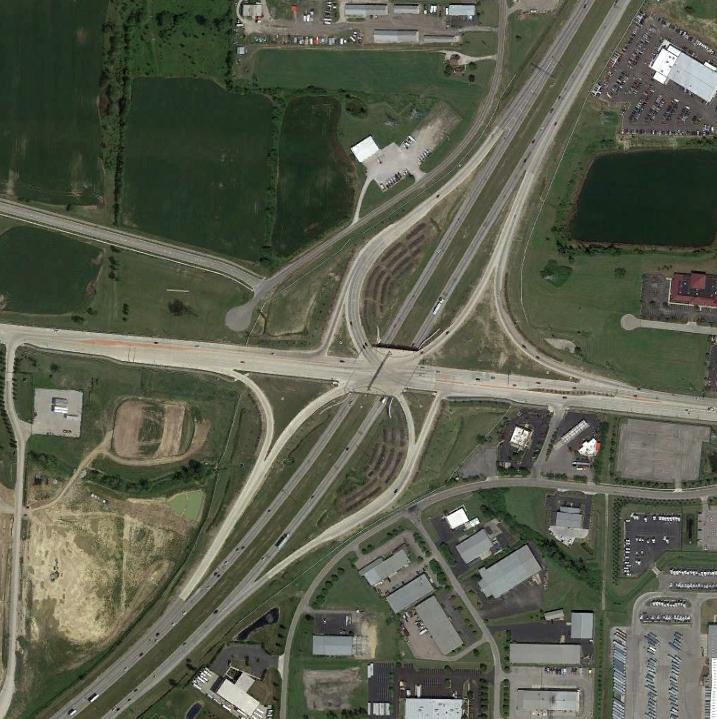
60 SR-161 & SUNBURY ROAD SPUI SPUI INTERCHANGE IS AN ALTERNATIVE TO A TYPICAL DIAMOND INTERCHANGE. DIAMOND INTERCHANGES TYPICALLY HAVE TWO CLOSE-SPACED SIGNALIZED INTERSECTIONS, WHERE CONGESTION OCCURS BETWEEN THE INTERSECTIONS THAT CAN BLOCK THE INTERSTATE RAMPS. THE TWO SIGNALIZED INTERSECTIONS ARE REPLACED WITH ONE SIGNALIZED INTERSECTIONS AND ALL 4 INTERSTATE RAMPS ARE CURVED TO CREATE A 4 LEGGED, 6 PHASE INTERSECTION AND RAMPS ARE ADDED, TYPICALLY, FOR CONTINUOUS FLOW RIGHT TURN MOVEMENTS.
61 CHALLENGES SR-161 & SUNBURY ROAD SPUI CLOSELY SPACED INTERCHANGES HIGH TRAFFIC VOLUMES ACCOMMODATE ALL TRAFFIC MOVEMENTS DESIGN WAS VERY COMPLEX WALLS & STRUCTURES WITH VARIOUS TRAFFIC SUPPORTS BUILT AS PART OF A $115M DOUBLE INTERCHANGE PROJECT COMPLETED IN 2007 THE SPUI ELIMINATED AN INTERSECTION/SIGNAL WITHIN THE COORIDOR MET PROJECT GOALS OF INCREASED CAPACITY AND SAFETY
62 LESSONS LEARNED AFTER 9 YEARS IN OPERATION CONSTRUCTION AND MAINTENANCE OF TRAFFIC WAS CHALLENGING OPERATIONS LARGEST CHALLENGE IS SIGNAL COORDINATION CD ROAD SIGNALS ARE CLOSE TO THE SPUI INTERSECTION MINOR CHANGES SINCE OPENING NB DUAL LEFT-TURN WAS LENGTHENED IN 2011 SPUI DOES NOT INCLUDE ANY PEDESTRIAN FEATURES OVERALL DESIGN IS NOT CONDUCIVE TO PEDESTRIAN ACCESS PEDESTRIAN ACCESS IS PERMITTED ONLY ON ONE LEG AT EACH CD ROAD INTERSECTION OVERALL, CONGESTION AT THE SPUI IS MINOR CD ROAD TRAFFIC FREQUENTLY BACKS UP ESPECIALLY EB


63 IR-270 & SAWMILL SPUI


64 IR-71 & SR-665 SPUI
65 QUESTIONS??
Innovative Intersections Presented by: Matt Crim P.E., PTOE Stantec Consulting Services Inc. October 29, 2015
 Innovative Intersections Presented by: Matt Crim P.E., PTOE Stantec Consulting Services Inc. October 29, 2015 1 Traditional Intersections Traditional Intersections allow left turns from all approaches.
INNOVATIVE INTERSECTION SOLUTIONS. Jay Bockisch, PE, PTOE Senior Associate
 INNOVATIVE INTERSECTION SOLUTIONS Jay Bockisch, PE, PTOE Senior Associate INNOVATIVE INTERSECTION SOLUTIONS Innovative intersection overview Case studies Continuous flow intersection Modern roundabouts
INNOVATIVE INTERSECTION DESIGN
 INNOVATIVE INTERSECTION DESIGN J. Eddie Valtier, P.E. ELP TP&D Director Introduction Why Do We Need To Start Looking For Innovative Intersection Designs? Congestion is worsening and traffic volumes and
Innovative Intersections
 Innovative Intersections Things You Need to Know About FDOT D-7 Safety Academy October 19, 2016 Mark Doctor FHWA Resource Center Atlanta, GA HOW DO YOU FEEL??? about innovative intersections??? Why is
HOWDY! Victor M. Vargas P.E. Assistant Director of Transportation Operations - Austin District Texas Department of Transportation
 HOWDY! Victor M. Vargas P.E. Assistant Director of Transportation Operations - Austin District Texas Department of Transportation Alternative Intersection Analysis The Do s & Don ts on Selling the Public
Access Management Benefits & Techniques. Access Management Workshop June 2, 2006
 Access Management Benefits & Techniques Access Management Workshop June 2, 2006 1 Benefits of Access Management Safety As access density increases, crash rates increase Increasing the density of access
Safety Evaluation at Innovative Geometric Designs Gilbert Chlewicki, PE Advanced Transportation Solutions
 2016 ITE Mid-Colonial District Annual Conference Wilmington, Delaware Safety Evaluation at Innovative Geometric Designs Gilbert Chlewicki, PE Advanced Transportation Solutions April 18, 2016 WHY INNOVATIVE
Offset Single Point Interchange I-25 at Rio Bravo Boulevard Albuquerque, New Mexico
 Offset Single Point Interchange I-25 at Rio Bravo Boulevard Albuquerque, New Mexico INSTITUTE OF TRANSPORTATION ENGINEERS 2016 WESTERN DISTRICT MEETING JULY 11, 2016 7/11/2016 1 Project Vicinity Map 7/11/2016
Highway 49, Highway 351 and Highway 91 Improvements Feasibility Study Craighead County
 Highway 49, Highway 351 and Highway 91 Improvements Feasibility Study Craighead County Executive Summary March 2015 Highway 49, Highway 351 and Highway 91 Improvements Feasibility Study Craighead County
SUPERSTREETS IN TEXAS. ITS Texas Annual Meeting San Marcos, Texas Session 6A - Operations November 11, 2011
 SUPERSTREETS IN TEXAS ITS Texas Annual Meeting San Marcos, Texas Session 6A - Operations November 11, 2011 1 Superstreet Corridor Location 2 3 US Highway 281 2007 Looking south above Evans Road, pm peak
M-58 HIGHWAY ACCESS MANAGEMENT STUDY Mullen Road to Bel-Ray Boulevard. Prepared for CITY OF BELTON. May 2016
 M-58 HIGHWAY ACCESS MANAGEMENT STUDY Prepared for CITY OF BELTON By May 2016 Introduction Missouri State Highway 58 (M-58 Highway) is a major commercial corridor in the City of Belton. As development has
VT15 / Allen Martin Drive Intersection Scoping Study
 VT15 / Allen Martin Drive Intersection Scoping Study ALTERNATIVES PRESENTATION MEETING DECEMBER 19, 2016 Agenda Study Area Project Background Existing Conditions Identified Issues Proposed Alternatives
DDI s Can Move More Than Cars! 2016 Western ITE Conference Albuquerque, NM July 12, 2016 Alex Ariniello, P.E. Public Works Director, Town of Superior
 DDI s Can Move More Than Cars! 2016 Western ITE Conference Albuquerque, NM July 12, 2016 Alex Ariniello, P.E. Public Works Director, Town of Superior Overview How did we get to the DDI concept? What s
Highway 217 Corridor Study. Phase I Overview Report
 Highway 217 Corridor Study Phase I Overview Report November 3, 24 BACKGROUND AND OVERVIEW Study purpose The Highway 217 Corridor Study is developing multi-modal transportation solutions for traffic problems
Route 7 (East Market Street) Interchange at Battlefield Parkway Town of Leesburg Project No: UPC Presentation to Town Council
 Interchange at Battlefield Parkway Town of Leesburg Project No: UPC Presentation to Town Council") Route 7 (East Market Street) Interchange at Battlefield Parkway Town of Leesburg Project No: 0007-253-109 UPC 106573 Presentation to Town Council June 26, 2017 Council Decisions East Market Street / Battlefield
Route 7 (East Market Street) Interchange at Battlefield Parkway Town of Leesburg Project No: 0007-253-109 UPC 106573 Presentation to Town Council June 26, 2017 Council Decisions East Market Street / Battlefield
Access Location, Spacing, Turn Lanes, and Medians
 Design Manual Chapter 5 - Roadway Design 5L - Access Management 5L-3 Access Location, Spacing, Turn Lanes, and Medians This section addresses access location, spacing, turn lane and median needs, including
SR 53 Corridor Study. Final Report Presentation. Friday, October 3, :00 AM to noon
 SR 53 Corridor Study Final Report Presentation Friday, October 3, 2014 10:00 AM to noon SR 53 Corridor Study Final Report Presentation Study Purpose: Investigate safety improvements along the SR 53 corridor
Superstreets. A Tool for Safely and Efficiently Managing Congestion
 Superstreets A Tool for Safely and Efficiently Managing Congestion Prepared for NORTH CAROLINA DEPARTMENT OF TRANSPORTATION TRAFFIC ENGINEERING AND SAFETY SYSTEMS BRANCH Original Superstreet Presentation
Mark Malone, P.E. SD DOT
 Mark Malone, P.E. SD DOT SD10 Grading & Surfacing From 8 th Ave W to 8 th Ave E 1 mile plus transition lengths Complete Urban Reconstruction Grading, C&G, Storm Sewer, Sidewalk, Concrete Surfacing Railroad
Access Management Regulations and Standards
 Access Management Regulations and Standards January 2014 Efficient highway operation Reasonable property access Concept of Access Management The way to manage access to land development while preserving
Active Traffic Management and Part-Time Shoulder Use in Montgomery County, PA
 Active Traffic Management and Part-Time Shoulder Use in Montgomery County, PA PENN STATE TESC SESSION 8B MOVING PENNDOT AND PTC FORWARD DECEMBER 8, 2017 Agenda Define Active Traffic Management and describe
Bay to Bay Boulevard Complete Streets Project
 Bay to Bay Boulevard Complete Streets Project Dale Mabry Highway to Bayshore Boulevard February 08, 2018 Photo Source: Tampa Bay Times Alessandra Da Pra Meeting Format Introduction Resurfacing Information
Frequently Asked Questions
 Frequently Asked Questions Business US 190 in Copperas Cove From Avenue D to Constitution Drive What is access management? A. Access Management is a growing effort by government agencies to improve how
Traffic Impact Analysis Chatham County Grocery Chatham County, NC
 Chatham County Grocery Chatham County, NC TABLE OF CONTENTS 1. INTRODUCTION... 1 1.1. Location and Study Area... 1 1.2. Proposed Land Use and Access... 2 1.3. Adjacent Land Uses... 2 1.4. Existing ways...
Optimizing The Operations of Closely Spaced Traffic Signals. Gordon E. Meth, P.E., PTOE ITE District 1 Annual Meeting May 21, 2004
 Optimizing The Operations of Closely Spaced Traffic Signals Gordon E. Meth, P.E., PTOE ITE District 1 Annual Meeting May 21, 2004 Closely Spaced Signals - The Challenges According to many sources, minimum
I-264 CORRIDOR EVALUATION STUDY. September 7, 2016 Eric Stringfield VDOT Planning Director Chris Lawrence AECOM Senior Transportation Engineer
 I-264 CORRIDOR EVALUATION STUDY September 7, 2016 Eric Stringfield VDOT Planning Director Chris Lawrence AECOM Senior Transportation Engineer Study Overview Interchange Locations Study Context Follow-up
Interstate Route 77 / US Route 62 / State Route 687 (Fulton Road) Transportation Improvement Project. Prepared September 6, 2017
 Transportation Improvement Project. Prepared September 6, 2017") EODOT Project: ODOT Project: STA-IR 77-.50; PID 00290 Interstate Route 77 / US Route 62 / State Route 687 (Fulton Road) Transportation Improvement Project Summary of Public Comments Received and Responses
EODOT Project: ODOT Project: STA-IR 77-.50; PID 00290 Interstate Route 77 / US Route 62 / State Route 687 (Fulton Road) Transportation Improvement Project Summary of Public Comments Received and Responses
THE FUTURE OF THE TxDOT ROADWAY DESIGN MANUAL
 THE FUTURE OF THE TXDOT ROADWAY DESIGN MANUAL Kenneth Mora, P.E. (Design Division) 10/10/2017 Table of contents 1 2 Reduction in FHWA design controlling criteria Innovative Intersection Guidance 3-7 8-42
Traffic Signal Design
 Traffic Signal Design Instructor: S. M. Mahdi Amiripour m.amiripour@gmail.com 2 Introduction Intersection is an area shared by two or more roads Designated for the vehicles to turn to different directions
PEDESTRIAN ACCOMMODATIONS DPS 201 AT INTERCHANGES
 PEDESTRIAN ACCOMMODATIONS DPS 201 AT INTERCHANGES UNDERSTANDING THE ISSUES Intersections of freeway ramp terminals at crossroads are the most critical components of an interchange Challenge: balance mobility
ROUNDABOUTS. Improving Safety and Efficiency. SR83 & Smithville Western Rd. Joel Montgomery, PE Director of Administration
 ROUNDABOUTS Improving Safety and Efficiency SR83 & Smithville Western Rd. Joel Montgomery, PE Director of Administration The Ohio Department of Transportation District 3 906 North Clark Ave. Ashland, OH
Highway 111 Corridor Study
 Highway 111 Corridor Study June, 2009 LINCOLN CO. HWY 111 CORRIDOR STUDY Draft Study Tea, South Dakota Prepared for City of Tea Sioux Falls Metropolitan Planning Organization Prepared by HDR Engineering,
Modern Roundabouts: a guide for application
 Modern Roundabouts: a guide for application Kentucky Community Transportation Innovation Academy 2005 The contents of this booklet reflect the views of the authors who are responsible for the facts and
Downtown Signals Traffic Analysis
 Downtown Signals Traffic Analysis City of St. Mary s April 16, 2018 Presented by: Allan Heitbrink, P.E. & Craig Eley, P.E. Who We Are Craig Eley, P.E o o o Previously the ODOT D7 Traffic and Safety Engineer.
PRELIMINARY DRAFT WADDLE ROAD / I-99 INTERCHANGE PROJECT ALTERNATIVE ANALYSIS FINAL TRAFFIC SUMMARY REPORT
 PRELIMINARY DRAFT WADDLE ROAD / I-99 INTERCHANGE PROJECT ALTERNATIVE ANALYSIS FINAL TRAFFIC SUMMARY REPORT Prepared by: In Association with: November 2013 EXECUTIVE SUMMARY Patton Township, in partnership
3 TRAFFIC CONTROL SIGNAL TIMING AND SYNCHRONIZATION
 Report No. 8 of the Transportation Services Committee Regional Council Meeting of October 20, 2011 3 TRAFFIC CONTROL SIGNAL TIMING AND SYNCHRONIZATION The Transportation Services Committee recommends:
Shockoe Bottom Preliminary Traffic and Parking Analysis
 Shockoe Bottom Preliminary Traffic and Parking Analysis Richmond, Virginia August 14, 2013 Prepared For City of Richmond Department of Public Works Prepared By 1001 Boulders Pkwy Suite 300, Richmond, VA
OTTAWA TRAIN YARDS PHASE 3 DEVELOPMENT CITY OF OTTAWA TRANSPORTATION IMPACT STUDY. Prepared for:
 OTTAWA TRAIN YARDS PHASE 3 DEVELOPMENT CITY OF OTTAWA TRANSPORTATION IMPACT STUDY Prepared for: The Ottawa Train Yards Inc. 223 Colonnade Road South, Suite 212 Nepean, Ontario K2E 7K3 January 17, 2012
MUTCD Part 6G: Type of Temporary Traffic Control Zone Activities
 MUTCD Part 6G: Type of Temporary Traffic Control Zone Activities 6G.01 Typical Applications Each temporary traffic control (TTC) zone is different. Many variables, such as location of work, highway type,
Capital Region Council of Governments
 March 23, 2018 Capital Region Council of Governments PROJECT CONCEPT REPORT Realignment of Swamp and Northfield Road s approaches to Route 44 (Boston Turnpike) Town of Coventry SUMMARY: The Town of Coventry
Comments EXECUTIVE SUMMARY
 Comments 1. Under any Alternatives, MCDOT should provide better at-grade pedestrian crossing of Georgia Avenue and Forest Glen Road, including improved crosswalks with wider medians and adequate signal
Access Management Regulations and Standards
 Access Management Regulations and Standards Efficient highway operation Reasonable property access Concept of Access Management The way to manage access to land development while simultaneously preserving
Roundabouts in Small-Medium Sized Communities: Why Consider Them?
 Roundabouts in Small-Medium Sized Communities: Why Consider Them? PRESENTORS: Dave Kliewer, PE J-U-B Engineers, Spokane Manager Spencer Montgomery J-U-B Engineers, Transportation Planner Roger Krieger
MEMORANDUM. DATE March 1, 2012 TO Town of Milton Mark Abbott, Seth Asante, and Efi Pagitsas Boston Region MPO Staff
 MEMORANDUM DATE March 1, 212 TO Town of Milton FROM RE Mark Abbott, Seth Asante, and Efi Pagitsas Boston Region MPO Staff FFY 211 Safety and Operations Analyses at Selected Boston Region MPO Intersections:
Appendix D: Concept Screening
 Concept Description Concept #1 Route 288 Roadway Widening This concept consists of constructing a third lane on northbound and southbound Route 288 between Powhite Parkway and US 360. This improvement
Public Meeting. I-35 Corridor from John Kilpatrick Turnpike North to Waterloo Road October 26, 6:00pm Edmond Community Center Auditorium
 Public Meeting I-35 Corridor from John Kilpatrick Turnpike North to Waterloo Road October 26, 2017 @ 6:00pm Edmond Community Center Auditorium Before we get started Please turn off or mute any electronic
ODOT DISTRICT CONSTRUCTION PROGRAM SERVING BUTLER, CLERMONT, CLINTON, GREENE, HAMILTON, PREBLE AND WARREN COUNTIES.
 ODOT DISTRICT 8 2018 CONSTRUCTION PROGRAM Preble Greene SERVING BUTLER, CLERMONT, CLINTON, GREENE, HAMILTON, PREBLE AND WARREN COUNTIES. Butler Hamilton Warren Clinton Lebanon Clermont John R. Kasich,
High Flow Multi-Lane Roundabouts
 High Flow Multi-Lane Roundabouts - Design Optimization - Project Examples Mark T. Johnson, P.E. MTJ Roundabout Engineering - City of Loveland CO 1994-1998 - Consulting Firm 1998-2001 - Key Contributor
ENHANCED PARKWAY STUDY: PHASE 2 CONTINUOUS FLOW INTERSECTIONS. Final Report
 Preparedby: ENHANCED PARKWAY STUDY: PHASE 2 CONTINUOUS FLOW INTERSECTIONS Final Report Prepared for Maricopa County Department of Transportation Prepared by TABLE OF CONTENTS Page EXECUTIVE SUMMARY ES-1
Brian McHugh, Buckhead Community Improvement District. SUBJECT: Wieuca Road at Phipps Boulevard Intersection Improvements Project
 MEMO TO: FROM: Brian McHugh, Buckhead Community Improvement District Jagan Kaja, AICP, WSP Parsons Brinckerhoff SUBJECT: Wieuca Road at Phipps Boulevard Intersection Improvements Project DATE: October
Project Issues. Kentucky s First DCD Interchange: One Year Later. Kentucky s First DCD Interchange One Year Later. Project Location.
 Kentucky s First DCD Interchange: One Year Later SEAUPG Annual Meeting November 13, 2012 Kentucky s First DCD Interchange One Year Later Project Background Project Schedule Post-Construction Findings http://transportation.ky.gov/us-68-double-crossover-diamond
METHODOLOGY. Signalized Intersection Average Control Delay (sec/veh)
") Chapter 5 Traffic Analysis 5.1 SUMMARY US /West 6 th Street assumes a unique role in the Lawrence Douglas County transportation system. This principal arterial street currently conveys commuter traffic
Chapter 5 Traffic Analysis 5.1 SUMMARY US /West 6 th Street assumes a unique role in the Lawrence Douglas County transportation system. This principal arterial street currently conveys commuter traffic
INTERCHANGES. Module 7
 INTERCHANGES Module 7 Learning Outcomes 7-2 At the end of this module, you will be able to: Identify how land uses around freeway interchanges create pedestrian trips Explain how and why pedestrian crashes
Pedestrian & Bicycle Safety Innovations & Applications
 Pedestrian & Bicycle Safety Innovations & Applications County Engineers Association of Maryland Spring, 2017 Conference May 25, 2017 George Branyan Pedestrian Program Coordinator District Department of
Justification and Feasibility of Roundabout
 Justification and Feasibility of Roundabout Shruti B. Khara M. E. Sem IV Transportation Engineering L. D. College of Engineering Ahmedabad e-mail shruti21063@gmail.com Prof. Ashutosh K. Patel Lecturer
H8 Signs, Supports and Poles
 Alberta Infrastructure and Transportation Roadside Design Guide November 2007 H8 Signs, Supports and Poles H8.1 Introduction This section identifies the appropriate roadside safety treatment for signs,
TRANSPORTATION ANALYSIS REPORT US Route 6 Huron, Erie County, Ohio
 TRANSPORTATION ANALYSIS REPORT US Route 6 Huron, Erie County, Ohio December 12, 2012 Prepared for: The City of Huron 417 Main Huron, OH 44839 Providing Practical Experience Technical Excellence and Client
Delaware Avenue Corridor Study
 Delaware Avenue Corridor Study City of Marysville, Ohio February 19, 2009 ms consultants, inc. engineers, architects, planners 2221 Schrock Road Columbus, Ohio 43229-1547 ms ms consultants, inc. engineers
Bicycle - Motor Vehicle Collisions on Controlled Access Highways in Arizona
 Bicycle - Motor Vehicle Collisions on Controlled Access Highways in Arizona Analysis from January 1, 1991 to June 30, 2002 Richard C. Moeur, PE Traffic Design Manager, Northern Region Michelle N. Bina
Introduction Roundabouts are an increasingly popular alternative to traffic signals for intersection control in the United States. Roundabouts have a
 HIGH-CAPACITY ROUNDABOUT INTERSECTION ANALYSIS: GOING AROUND IN CIRCLES David Stanek, PE and Ronald T. Milam, AICP Abstract. Roundabouts have become increasingly popular in recent years as an innovative
Financial Project ID No(s).: and ETDM No(s).: and 14181
.: and ETDM No(s).: and 14181") Palm Beach Metropolitan Planning Organization (MPO) Presentation I-95 at Boynton Beach Boulevard Interchange and I-95 at Gateway Boulevard Interchange Project Development and Environment Study Palm Beach
Palm Beach Metropolitan Planning Organization (MPO) Presentation I-95 at Boynton Beach Boulevard Interchange and I-95 at Gateway Boulevard Interchange Project Development and Environment Study Palm Beach
WELCOME. Stakeholder Involvement Group Meeting #2 Round Lake Public Works October 24, 2018
 WELCOME Stakeholder Involvement Group Meeting #2 Round Lake Public Works October 24, 2018 MEETING AGENDA 1. Welcome and Introductions 2. Study Progress Update 3. Problem Statement 4. Technical Analysis
OFFICE/RETAIL DEVELOPMENT 1625 BANK STREET OTTAWA, ONTARIO TRANSPORTATION BRIEF. Prepared for: Canada Inc.
 OFFICE/RETAIL DEVELOPMENT 1625 BANK STREET OTTAWA, ONTARIO TRANSPORTATION BRIEF Prepared for: 9402209 Canada Inc. December 15, 2015 115-625 Report_2.doc D. J. Halpenny & Associates Ltd. Consulting Transportation
Terwillegar Drive Expressway Draft Concept Plan
 Terwillegar Drive Expressway Draft Concept Plan Anthony Henday Drive to Whitemud Drive November 28 5:00-8:00 p.m. December 1 10:00 a.m. - 3:00 p.m. Let s Talk Today you can: Learn about the new direction
Lincoln Avenue Road Diet Trial
 Lincoln Avenue Road Diet Trial Data Collection Report June 1, 2015 Department of Transportation Table of Contents I. Introduction...... 3 II. Data Collection Methodology & Results...... 5 A. Traffic Volume
APPENDIX G: INTERSECTION NEEDS AT OKEECHOBEE BOULEVARD
 APPENDIX G: INTERSECTION NEEDS AT OKEECHOBEE BOULEVARD INTERSECTION NEEDS AT SR 7 and OKEECHOBEE BOULEVARD SR 7 Extension Project Development and Environment (PD&E) Study From Okeechobee Boulevard (SR
180 Grand Avenue, Suite x117 Dowling Associates, Inc.
 180 Grand Avenue, Suite 250 510.839.1742 x117 Oakland, CA 94612 510.839.0871 fax www.dowlinginc.com mbowman@dowlinginc.com Dowling Associates, Inc. Date: Memorandum To: CC: From: Ms. Leah Greenblat City
91
 90 91 92 93 94 95 96 97 98 99 100 101 102 103 104 105 106 As previously depicted in Exhibit 4-J, vehicular accidents are shown along Forrester Road. The contributing factors may be due to its current two
Iowa Highway 58 Corridor Improvement Study
 1 Iowa Highway 58 Corridor Improvement Study Public Informational Meeting May 6, 2014 2 Welcome and Introductions Randy Lorenzen, City of Cedar Falls Engineer 3 Outline of Presentation Review of Project
Executive Summary June 2015
 Executive Summary June 2015 Highway 112 Corridor Study Benton and Washington Counties Executive Summary June 2015 Prepared by Transportation Planning and Policy Division Arkansas State Highway and Transportation
City of Wayzata Comprehensive Plan 2030 Transportation Chapter: Appendix A
 A1. Functional Classification Table A-1 illustrates the Metropolitan Council s detailed criteria established for the functional classification of roadways within the Twin Cities Metropolitan Area. Table
PennDOT ICE Policy An Introduction
 PennDOT ICE Policy An Introduction January 2018 What is Intersection Control Evaluation (ICE)? Purpose: To consistently consider and screen among many proven combinations of geometry and traffic control
Strategies to Re capture Lost Arterial Traffic Carrying Capacities
 Strategies to Re capture Lost Arterial Traffic Carrying Capacities Chalap K. Sadam, P.E. and Albert L. Grover, P.E. Over the years, many arterials that were initially designed to carry tens of thousands
TRAFFIC IMPACT ANALYSIS
 TRAFFIC IMPACT ANALYSIS FOR THE CHAMPAIGN UNIT#4 SCHOOL DISTRICT PROPOSED HIGH SCHOOL (SPALDING PARK SITE) IN THE CITY OF CHAMPAIGN Final Report Champaign Urbana Urbanized Area Transportation Study 6/24/2014
A Diet that Works AMATS Road Diet Analysis
 A Diet that Works AMATS Road Diet Analysis Curtis Baker, Planning Administrator David Pulay, Transportation Engineer October 2015 Overview What is a Road Diet? The Big Picture Why does an MPO care about
STANLEY STREET December 19, 2017
 STANLEY STREET December 19, 2017 Welcome Mike Wiza, Mayor Scott Beduhn, Director of Public Works Agenda 1. Introduction 2. Existing Roadway Conditions 3. Current Alternative Improvements 4. Summary of
Traffic Impact Analysis Walton Acres at Riverwood Athletic Club Clayton, NC
 Traffic Impact Analysis Walton Acres at Riverwood Athletic Club Clayton, NC 1. TABLE OF CONTENTS INTRODUCTION...1 1.1. Site Location and Study Area...1 1.2. Proposed Land Use and Site Access...2 1.3.
3.0 PROJECT DESCRIPTION
 The following section of the Draft EIR contains a description of the proposed Elk Grove Boulevard/SR 99 Interchange Modification project, consistent with the requirements of CEQA Guidelines Section 15124.
ACCESS MANAGEMENT PLAN FOR SR-741 & MIAMISBURG-SPRINGBORO/ AUSTIN PIKE MONTGOMERY COUNTY, OHIO
 ACCESS MANAGEMENT PLAN FOR SR-741 & MIAMISBURG-SPRINGBORO/ AUSTIN PIKE MONTGOMERY COUNTY, OHIO Prepared For: Miami Valley Regional Planning Commission (MVRPC) Prepared By: DLZ Ohio, Inc. Project #0321-1003-00
2015 MAJOR TRANSPORTATION CONSTRUCTION PROJECTS UPDATE
 2015 MAJOR TRANSPORTATION CONSTRUCTION PROJECTS UPDATE 2015 MAJOR TRANSPORTATION CONSTRUCTION PROJECTS HOLD HARD ROAD & SAWMILL ROAD INTERSECTION HARD ROAD WIDENING RIVERSIDE DRIVE REALIGNMENT I-270/US
INTERSECTION SAFETY STUDY State Route 57 / Seville Road
 INTERSECTION SAFETY STUDY State Route 57 / Seville Road City of Wadsworth, Medina County, Ohio Prepared For: City of Wadsworth Engineering Department 120 Maple Street Wadsworth, OH 44281 Prepared By: GPD
Chapter 4 Traffic Analysis
 Chapter 4 Traffic Analysis PURPOSE The traffic analysis component of the K-68 Corridor Management Plan incorporates information on the existing transportation network, such as traffic volumes and intersection
ALLEY 24 TRAFFIC STUDY
 ALLEY 24 TRAFFIC STUDY in City of Frostburg, Maryland January 2013 3566 Teays Valley Road Hurricane, WV Office: (304) 397-5508 www.denniscorporation.com Alley 24 Traffic Study January 2013 Frostburg, Maryland
Access Management Regulations and Standards for Minor Arterials, Collectors, Local Streets
 Access Management Regulations and Standards for Minor Arterials, Collectors, Local Streets September 2009 Paul Grasewicz Access Management Administrator Concept of Access Management The way to manage access
Diverging Diamond Interchange and Double Crossover Intersection Vehicle and Pedestrian Performance
 Diverging Diamond Interchange and Double Crossover Intersection Vehicle and Pedestrian Performance Praveen K. Edara, Department of Civil and Environmental Engineering, Virginia Polytechnic Institute and
BETHEL ROAD AND SEDGWICK ROAD CORRIDOR STUDY
 DRAFT PLAN City Council Meeting August 14, 2017 STUDY AREA Sedgwick Corridor State Route 160, principal arterial with Class 3 access management designation, commuter and freight route, connection to SR
Superstreet Concepts & Application. Prepared by: PAPE-DAWSON ENGINEERS, INC. October 16, 2012
 Superstreet Concepts & Application Prepared by: PAPE-DAWSON ENGINEERS, INC. October 16, 2012 1 Purpose of a Superstreet Improve Traffic Flow Increased Safety Economical Solution What is a Superstreet?
Welcome! San Jose Avenue Open House August 25, 2015
 Welcome! San Jose Avenue Open House August 25, 2015 Vision Zero The City and County of San Francisco adopted Vision Zero San Francisco Vision Zero High Injury Network as a policy in 2014, committing an
FHWA Safety Performance for Intersection Control Evaluation (SPICE) Tool
 Tool") FHWA Safety Performance for Intersection Control Evaluation (SPICE) Tool Virginia Section ITE Annual Meeting Virginia Beach June 217 Pete Jenior Kittelson & Associates, Inc. 1 Intersection Control Evaluation
FHWA Safety Performance for Intersection Control Evaluation (SPICE) Tool Virginia Section ITE Annual Meeting Virginia Beach June 217 Pete Jenior Kittelson & Associates, Inc. 1 Intersection Control Evaluation
Mineral Avenue Corridor Assessment. ITE 2017 Western District Annual Meeting San Diego, CA June 21 st
 Mineral Avenue Corridor Assessment ITE 2017 Western District Annual Meeting San Diego, CA June 21 st Biography - Aaron Heumann, PE, PTOE Currently City of Littleton Transportation Engineering Manager 24
133 rd Street and 132 nd /Hemlock Street 132 nd Street and Foster Street MINI ROUNDABOUTS. Overland Park, Kansas
 133 rd Street and 132 nd /Hemlock Street 132 nd Street and Foster Street MINI ROUNDABOUTS Overland Park, Kansas September 1, 2017 TABLE OF CONTENTS 1. INTRODUCTION... 1 2. LITERATURE REVIEW... 1 3. CONCEPT
Welcome. Thank you for attending tonight s open house. The purpose of this open house is to give you an opportunity to:
 Welcome Thank you for attending tonight s open house. The purpose of this open house is to give you an opportunity to: Review the circulation plan concept Give us your input Why a circulation plan? During
Truck Climbing Lane Traffic Justification Report
 ROUTE 7 (HARRY BYRD HIGHWAY) WESTBOUND FROM WEST MARKET STREET TO ROUTE 9 (CHARLES TOWN PIKE) Truck Climbing Lane Traffic Justification Report Project No. 6007-053-133, P 101 Ι UPC No. 58599 Prepared by:
City Avenue Projects
 City Avenue Projects City Avenue Special Services District Conceived in the early 1990 s Lita Cohen, Jim Ettelson, Joe Manko, and Michael Nutter Saint Joseph s provided key start-up support. True Public/Private
PRESENTATION OUTLINE
 November 8, 2017 PRESENTATION OUTLINE Regional Express Lanes Network Purpose/Benefits of Express Lanes 95 Express Phase 3C Project Video and Overview 95 Express Phase 3C Schedule 2 SOUTH FLORIDA REGIONAL
Grade Separated Intersection
 Grade Separated Intersection Lecture Notes in Transportation Systems Engineering Prof. Tom V. Mathew Contents 1 Overview 1 2 Classification of Intersection 2 2.1 Grade Separated Intersection...........................
Waterford Lakes Small Area Study
 Waterford Lakes Small Area Study Existing Traffic Conditions PREPARED FOR: ORANGE COUNTY PUBLIC WORKS DEPARTMENT TRAFFIC ENGINEERING DIVISION ORLANDO, FLORIDA PREPARED WITH: INWOOD CONSULTING ENGINEERS
DEPARTMENT OF ENVIRONMENTAL SERVICES. North Harrison Street (Lee Highway to Little Falls Road) Comparative Analysis. Prepared for:
 Comparative Analysis. Prepared for:") DEPARTMENT OF ENVIRONMENTAL SERVICES North Harrison Street (Lee Highway to Little Falls Road) Comparative Analysis Prepared for: Arlington County Department of Environmental Services 2100 Clarendon Boulevard,
DEPARTMENT OF ENVIRONMENTAL SERVICES North Harrison Street (Lee Highway to Little Falls Road) Comparative Analysis Prepared for: Arlington County Department of Environmental Services 2100 Clarendon Boulevard,
Benefits and Limitations of J- Turn Intersections
 Benefits and Limitations of J- Turn Intersections Ernest B. Perry, Eric Oberhart, Steven Wagner, and Teresa Adams Mid-America Freight Coalition National Center for Freight and Infrastructure Research and
Harrah s Station Square Casino
 Transportation Analysis Harrah s Station Square Casino Pittsburgh, Pennsylvania Submitted To: City of Pittsburgh and Pennsylvania Gaming Control Board Prepared By: DKS Associates GAI Consultants December