I-290 Phase I Study Village of Forest Park November 9, of 25
|
|
|
- Silas Rogers
- 5 years ago
- Views:
Transcription


1 I-290 Phase I Study Village of Forest Park November 9, of 25
 Re-striping Section (4 miles)")


2 I-290 Study Area Reconstruction Section (9 miles) Re-striping Section (4 miles) 13 miles West of Mannheim Road to Racine Avenue Connects between: I-88 on the west Jane Bryne Interchange on the east Jane Bryne Interchange Improvements 2 of 25

3 I-290 Study Overview 3 of 25


4 Public Involvement Efforts 21 Corridor Advisory Group/ Task Force Meetings Over 100 Community and Transit Agency Meetings 6 Newsletters and Factsheets 3Public Meetings 4 of 25

5 Transportation Needs, Alternatives Summary Transportation needs to be addressed Mobility, safety, condition, design Connections between travel modes Access to jobs OVERALL GOAL Create an asset for adjoining communities 5 of 25

 HCT Extension Add 1 lane (HOV 2+) 3")
6 Transportation Needs, Alternatives Summary Alternatives development evaluation Three evaluation rounds, CTA Blue Line Vision Study Engineering considerations Evaluation rounds 1 and 2 conceptual alternatives, travel model Evaluation round 3 geometry Environmental Considerations Communities are the environment Noise, air quality HOV 2+ Express Bus 3 lanes Add 1 lane (HOV 2+) HCT Extension Add 1 lane (HOV 2+) 3 lanes 6 of 25
7 CTA Vision Study Recommendations Complete reconstruction/modernization for the Forest Park branch Bring existing service speeds up to state of good repair Maintain existing station access Maintain existing service no 3 rd track or express service Remove stations closed in the 1970 s Redesign Forest Park terminal, yard and shop Work with IDOT to refine design, develop staging concept, explore joint funding opportunities Preserve footprint for future extension (supportive land use required) 7 of 25

8 Preliminary Preferred Alternative HOT 3+ & Supporting Transit 88 Mannheim Rd. Des Plaines Austin Blvd. Racine Ave. 90/94 Existing Condition 4 lanes 3 lanes 3 lanes 4 lanes 4 lanes I-290 I mi 3.5 mi 2.1 mi 6.1 mi 0.5 mi Preferred Alternative HOT 3+ Express Bus 3 lanes 3 lanes Add 1 lane (HOT 3+) Convert 1 lane (HOT 3+) Blue Line Extension Add 1 lane (HOT 3+) Convert 1 lane (HOT 3+) 3 lanes 3 lanes SUPPORTING TRANSIT > Bus feeder service > Blue Line extension to Mannheim Initial service option - bus in managed lane I-290 corridor improvements will enable/leverage transit improvements 8 of 25
9 DesPlaines Avenue Circle Avenue Harlem Avenue 9 of 25

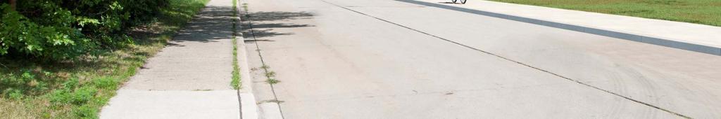
10 DesPlaines Ave. Improvements Proposed design compatible with future CTA Terminal concept Simplify intersection at I-290 ramp and CTA Extended southbound right turn lane to I-290 Modern traffic signals Signal protected ramp crossing Improved / wider sidewalks (ADA) On-street bike lanes New shared use path & connections Shared use path bridge over DesPlaines Avenue Aesthetic opportunities 10 of 25

11 Circle Avenue Improvements Wider sidewalks 16-feet wide at CTA station 12-feet wide along west side Dedicated directional bike lanes New CTA Blue Line head station Kiss and Ride pullout-waiting area New Shared Use Path & connections Modern traffic signal at Harrison Street Improved lighting Aesthetic opportunities 11 of 25

12 Harlem Ave Improvements Right hand ramps Keeps intersection in same location Partial decking over I-290 Wide sidewalks & pedestrian plaza areas (ADA) Pedestrian refuge islands between ramps New pedestrian crossings of Harlem Avenue New shared use path & connection Modern signals with ped countdown timers Improved operations Up to 36% delay reduction Up to 44% queue reduction 12 of 25
13 Noise Analysis & Noise Walls 13 of 25

14 1 Identify Noise Receptors Worst-case noise location Outdoor activity area Residence Restaurant Office Courthouse Residence Cemetery 14 of 25


")
15 2 Traffic Noise Level Determination Noise calculated at worst-case locations Predict traffic noise levels using the FHWA Traffic Noise Model (TNM) Validate model by field monitoring 15 of 25

 residential 2. 72 db(a) commercial 3.")
 2.")
16 3 Traffic Noise Impact Identification Impacts identified for worst-case locations 1. FHWA Noise Abatement Criteria (NAC) db(a) residential db(a) commercial 3. NAC is a trigger to study abatement 4. Existing, 2040 No Build over 67 db(a) 2. Proposed project would not result in substantial noise increases 16 of 25
17 4 Traffic Noise Abatement Analysis Abatement analysis completed in areas with impacts Noise walls only option for I-290 corridor Each receptor studied for abatement Noise walls must: Be constructible Achieve noise reductions of 5 and 8 db(a) Pass a benefit/cost calculation Be supported by those it benefits acoustically (voting) Viewpoints solicitation 17 of 25
18 Viewpoints Solicitation Rental properties: One vote for tenant, one vote for owner (per unit) Receptors that share property line with I-290 receive TWO VOTES Up to TWO ROUNDS of voting to MAXIMIZE response rates RESPONSE GOAL OF 33% of benefited receptors per proposed barrier If more than half of the votes are in favor of a barrier, the proposed abatement measure will be likely to be implemented 18 of 25


19 Proposed Noise Walls Forest Park 19 of 25


20 Before & After Visualizations Existing Lehmer Street and Beloit Ave Forest Park 20 of 25

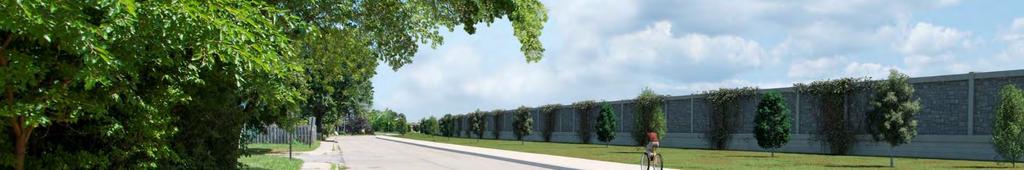

21 Before & After Visualizations With Noise Wall Lehmer Street and Beloit Ave Forest Park 21 of 25


22 Harlem Ave Ramp Without noise wall Lehmer Street & Marengo Drive Forest Park 22 of 25


23 Harlem Ave Ramp With noise wall Lehmer Street & Marengo Drive Forest Park 23 of 25


24 Next Steps - Overall Noise analysis and coordination Technical Analysis Community and agency meetings continued Noise Wall Viewpoints Solicitation Surveys Early November Corridor Advisory Group #22 February 2016 Draft Environmental Impact Statement Release February 2016 Public Hearing March 2016 Corridor Advisory Group #23 Summer 2016 Final Environmental Impact Statement/Record of Decision Fall of 25


25 Thank You Also, please visit Additional project information and updates Project contact information On-line comment form 25 of 25
Maywood Town Hall Meeting. May 4, 2016
 Maywood Town Hall Meeting May 4, 2016 1 AGENDA Overall I-290 Study Background Maywood Advisory Working Group (AWG) findings to date Noise Wall Update Next Steps 2 Questions? Study team members also available
I-290 Phase I Study Area OAK PARK AVE AUSTIN BLVD. Reconstruction Area (9 miles) Oak Park RIDGELAND AVE CENTRAL AVE HARLEM AVE. Cicero.
 Oak Park RIDGELAND AVE CENTRAL AVE HARLEM AVE. Cicero.") RIDGELAND AVE OAK PARK AVE AUSTIN BLVD UP-RR BRC-RR ASHLAND AVE Study Area Map I-290 Phase I Study Area 294 UP RR Metra UP-W Illinois Prairie Path 38 Berkeley WOLF RD Hillside MANNHEIM RD Bellwood 290
RIDGELAND AVE OAK PARK AVE AUSTIN BLVD UP-RR BRC-RR ASHLAND AVE Study Area Map I-290 Phase I Study Area 294 UP RR Metra UP-W Illinois Prairie Path 38 Berkeley WOLF RD Hillside MANNHEIM RD Bellwood 290
Corridor Advisory Group Meeting #21. October 15, 2015
 Corridor Advisory Group Meeting #21 October 15, 2015 Agenda CAG #20 Recap Study Timeline Round 3 Wrap-Up/Results Air Quality Noise Analysis Environmental Justice Preliminary Preferred Alternative Recommendation
Corridor Advisory Group and Task Force Meeting #10. July 27, 2011
 Corridor Advisory Group and Task Force Meeting #10 July 27, 2011 1 Agenda Recap CAG/TF #9 Public Meeting #2 Summary Single Mode Alternatives Evaluation Results Next Steps 2 3 CAG/TF #9 Recap CAG /TF #9
Managed Lanes. Steve Schilke, P.E. Major Projects Unit Head District 1. Illinois Traffic Engineering and Safety Conference October 2016
 Managed Lanes Steve Schilke, P.E. Major Projects Unit Head District 1 Illinois Traffic Engineering and Safety Conference October 2016 Agenda Managed Lanes Projects I-55 (Stevenson Expressway) Express Toll
Environmental Assessment Findings & Recommendations. Public Hearing November 13, 2014
 Environmental Assessment Findings & Recommendations Public Hearing November 13, 2014 Welcome! Welcome and Introductions Project and Environmental Assessment Overview Public Comments Adjourn Purpose of
Comprehensive Collection of Stakeholder Alternatives by Mode
 2011 Illinois Department of Transportation Comprehensive Collection of Stakeholder Alternatives by Mode October 2009 January 2011 www.dot.il.gov www.eisenhowerexpressway.com FILEY RD FILEY RD IHB RR 2
5. RUNNINGWAY GUIDELINES
 5. RUNNINGWAY GUIDELINES These guidelines should be considered collectively when making runningway decisions. A runningway is the linear component of the transit system that forms the right-of-way reserved
Initial Alternatives Identification and Evaluation Report. November 2011 APPENDIX B. Summary of Stakeholder Single Mode Suggestions
 Initial Alternatives Identification and Evaluation Report ovember 2011 APPEDIX B Summary of Stakeholder Single Mode Suggestions 2011 Illinois Department of Transportation Summary of Stakeholder Alternatives
Princeton Avenue and Spruce Street Transportation and Site Access Enhancements Project
 Princeton Avenue and Spruce Street Transportation and Site Access Enhancements Project Mercer County Planning Division AECOM Transportation (formerly DMJM Harris) January 29, 2009 Agenda Project Status
Geary Corridor Bus Rapid Transit
 Geary Corridor Bus Rapid Transit Near-term Improvements Update SAN FRANCISCO COUNTY TRANSPORTATION AUTHORITY SAN FRANCISCO MUNICIPAL TRANSPORTATION AGENCY Phasing Packages Phase 1 Near-term: Delivers project
Terwillegar Drive Expressway Draft Concept Plan
 Terwillegar Drive Expressway Draft Concept Plan Anthony Henday Drive to Whitemud Drive November 28 5:00-8:00 p.m. December 1 10:00 a.m. - 3:00 p.m. Let s Talk Today you can: Learn about the new direction
About the study. North Milwaukee Ave. Key goals of this study are to: Achieve Vision Zero* by. Harmonize the space and improve walkability
 About the study Key goals of this study are to: North Milwaukee Avenue is a local and regional street for multiple modes of transportation. It is officially zoned and functions as a pedestrian street southeast
US 20 Feasibility Study. Village Board Meeting. Shales Parkway to IL Route 390 IL Route 390 Extension (North Ave to US 20)
") US 20 Feasibility Study Shales Parkway to IL Route 390 IL Route 390 Extension (North Ave to US 20) Village Board Meeting Bartlett Village Hall February 16, 2016 1 Background 1991 IDOT Study Recommendations
US 20 Feasibility Study Shales Parkway to IL Route 390 IL Route 390 Extension (North Ave to US 20) Village Board Meeting Bartlett Village Hall February 16, 2016 1 Background 1991 IDOT Study Recommendations
Thank you for attending
 Improving mobility safety comfort WELCOME Thank you for attending The purpose of this meeting is to: Learn about the project Prioritize potential walking and biking improvements on Snelling Ave Gather
Hennepin/First Transportation Study
 CITY OF MINNEAPOLIS Hennepin/First Transportation Study NIEBNA Board Meeting November 10, 2016 11/10/2016 1 Study Overview Evaluate transportation system and alternatives Coordinate with County, Metro
HARRISON STREET/OAKLAND AVENUE COMMUNITY TRANSPORTATION PLAN
 HARRISON STREET/OAKLAND AVENUE Community Workshop #4: Draft Plan Review December 3, 2009 D E S I G N, C O M M U N I T Y & E N V I R O N M E N T INTRODUCTIONS Key Project Staff: Alisa Shen, Project Manager,
PROJECT OVERVIEW. 20th Avenue Project Limits (Lincoln Way to Wawona St)
") PROJECT OVERVIEW In 2014, San Francisco adopted Vision Zero as City policy, with a commitment to eliminate all traffic deaths in the City by 2024. nue Project Limits (Lincoln Way to St) Collision data
PROJECT OVERVIEW In 2014, San Francisco adopted Vision Zero as City policy, with a commitment to eliminate all traffic deaths in the City by 2024. nue Project Limits (Lincoln Way to St) Collision data
95 th Street Corridor Transportation Plan. Steering Committee Meeting #2
 95 th Street Corridor Transportation Plan Steering Committee Meeting #2 February 18, 2015 PURPOSE OF THE MEETING Update Steering Committee Present Community/Stakeholder Survey Results Present Transportation
Public Meeting #2 May 18, 2011 Comment Summary by Category
 Multi-modal Options The mode of transportation which should be used is an increased option of mass transit. Light rail should be added. Express rail with Park N Rides will provide a short, safe means of
Bay to Bay Boulevard Complete Streets Project
 Bay to Bay Boulevard Complete Streets Project Dale Mabry Highway to Bayshore Boulevard February 08, 2018 Photo Source: Tampa Bay Times Alessandra Da Pra Meeting Format Introduction Resurfacing Information
Summary: Mercer County Princeton Avenue & Spruce Street Study January 2009
 Summary: Several recent studies have assessed potential development and redevelopment opportunities in the Mercer Crossing area of Trenton, Ewing, and Lawrence. This Princeton Avenue and Spruce Street
NEWMARKET UPHAM S CORNER
 SOUTH STATION Planning Initiative NEWMARKET UPHAM S CORNER COLUMBIA ROAD (P) FOUR CORNERS/GENEVA Working Advisory Group (WAG) Meeting #5 TALBOT AVENUE MORTON STREET BLUE HILL AVE/CUMMINS HWY (P) RIVER
Commerce Street Complete Street Project from Good Latimer Expressway to Exposition Avenue
 Commerce Street Complete Street Project from Good Latimer Expressway to Exposition Avenue T A N Y A B R O O K S A S S I S T A N T D I R E C T O R M O B I L I T Y P L A N N I N G M O B I L I T Y A N D S
Hennepin County Bicycle and Pedestrian Planning
 Hennepin County Bicycle and Pedestrian Planning 1 Value of bicycle and sidewalk systems Safety Livability Mobility Health Personal Finances Economic Sustainability Clean Air Recreation Parking and congestion
I-66 Corridor Improvements Route 15 to I-495. November 2014
 I-66 Corridor Improvements Route 15 to I-495 November 2014 I-66 Corridor: Haymarket to the Beltway = Park and Ride Lots 2 Purpose and Need Improve multimodal mobility along the I-66 corridor by providing
Lawrence Avenue Streetscape Concepts August 30, 2011
 Lawrence Avenue Streetscape Concepts August 30, 2011 Neighborhood Context Phase II: River to Western Ave. Phase I: Western Ave. to Clark St. Key Map Lawrence Ave. Existing Streetscape Conditions East of
Freeway ramp intersection study
 Freeway ramp intersection study Supporting Vision Zero: Zero traffic deaths in San Francisco by 2024 Study Goals: Primary Improve Safety Improve Accessibility Secondary Provide Efficient Circulation Accommodate
Geary Corridor Bus Rapid Transit SFMTA Citizens Advisory Committee
 Geary Corridor Bus Rapid Transit SFMTA Citizens Advisory Committee Project Update SAN FRANCISCO COUNTY TRANSPORTATION AUTHORITY SAN FRANCISCO MUNICIPAL TRANSPORTATION AGENCY August 6, 2015 Project Overview
122 Avenue: 107 Street to Fort Road
 : 107 Street to Fort Road November 24, 2015 4:30 8:00 p.m. Meeting Purpose Summarize project work completed to date Share results of public input from Phase 1 Share the draft concept plan and proposed
Queensboro Bridge Bus Priority Study: Summary of Recommendations. Presentation to Manhattan Community Board 8 May 4, 2011
 : Summary of Recommendations Presentation to Manhattan Community Board 8 May 4, 2011 1 Overview Study Goal: Identify cost-effective ways to improve bus speed and reliability for local and express buses
Building Great Neighbourhoods BELLEVUE AND VIRGINIA PARK
 Building Great Neighbourhoods BELLEVUE AND VIRGINIA PARK This is Meeting 2 Unfortunately, some residents in Bellevue and Virginia Park received the wrong information for this public open house (Meeting
U.S. Route 45 (IL 132 to IL 173 and Millburn Bypass) Frequently Asked Questions
 Frequently Asked Questions") U.S. Route 45 (IL 132 to IL 173 and Millburn Bypass) Frequently Asked Questions This document provides responses to the frequently asked questions pertaining to the U.S. Route 45; IL Route 132 to IL Route
U.S. Route 45 (IL 132 to IL 173 and Millburn Bypass) Frequently Asked Questions This document provides responses to the frequently asked questions pertaining to the U.S. Route 45; IL Route 132 to IL Route
KEARNY MESA COMMUNITY PLAN UPDATE
 KEARNY MESA COMMUNITY PLAN UPDATE January 18, 2018 SUBCOMMITTEE MEETING Mobility Concepts and Urban Design Presentation Outline Mobility Concepts: Multimodal Planning Toolbox Presentation and Activities
DULLES AREA TRANSPORTATION ASSOCIATION (DATA) February 18, Susan Shaw, P.E., VDOT, Megaprojects Director
 February 18, Susan Shaw, P.E., VDOT, Megaprojects Director") DULLES AREA TRANSPORTATION ASSOCIATION (DATA) February 18, 2015 Susan Shaw, P.E., VDOT, Megaprojects Director I-66 Corridor Conditions Steady population growth Employment growth in activity centers Congestion
DULLES AREA TRANSPORTATION ASSOCIATION (DATA) February 18, 2015 Susan Shaw, P.E., VDOT, Megaprojects Director I-66 Corridor Conditions Steady population growth Employment growth in activity centers Congestion
Display Boards Including Five Refined Design Concepts
 APPENDIX D Workshop Session 3 Sign-in sheets Agenda Booklet Display Boards Including Five Refined Design Concepts PowerPoint Presentation Questions Recorded Discussion of Preference Exercise AGENDA
95 th Street Corridor Transportation Plan. Steering Committee Meeting
 95 th Street Corridor Transportation Plan Steering Committee Meeting August 11, 2014 PROJECT OBJECTIVES Develop a Transportation and Economic Plan for the 95 th Street Corridor Improve public transit efficiency
Welcome and Introductions Overview of the Study to Date Community Involvement Intersection Improvement Concepts Bike-Ped Recommendations ITS
 Welcome and Introductions Overview of the Study to Date Community Involvement Intersection Improvement Concepts Bike-Ped Recommendations ITS Recommendations Transit Recommendations Next Steps Inventoried
MASTER BICYCLE AND PEDESTRIAN PLAN
 VILLAGE OF NORTHBROOK MASTER BICYCLE AND PEDESTRIAN PLAN DRAFT PLAN OPEN HOUSE May 2, 2018 AGENDA 1. Community Engagement 2. Vision and Goals 3. General Structure of Plan 4. Recommendations Overview 5.
BALBOA AREA: TRANSPORTATION PROJECTS & PLANNING
 BALBOA AREA: TRANSPORTATION PROJECTS & PLANNING TRANSPORTATION FOR ALL AGES, ABILITIES & MEANS CHANGING PATTERNS: TRENDING TO WALKING, BIKING, TRANSIT San Francisco s Change in Number of Commuters by Mode
Colchester/Riverside/Barrett/ Mill Intersection Study. PAC Meeting #3 September 22, 2016
 Colchester/Riverside/Barrett/ Mill Intersection Study PAC Meeting #3 September 22, 2016 Tonight s Agenda Review Project Purpose and Need Describe short term and long improvements and changes since public
Welcome! Thank you for joining us today for a Geary Rapid project open house. Geary Rapid Project. SFMTA.com/GearyRapid
 Welcome! Thank you for joining us today for a Geary Rapid project open house. Get the most out of this event: 1. Sign in and get your feedback sheet 2. Visit project information stations hosted by project
Brooklyn Boulevard (County Road 152) Reconstruction Project Phase I. OPEN HOUSE June 20, 2017
 Reconstruction Project Phase I. OPEN HOUSE June 20, 2017") Brooklyn Boulevard (County Road 152) Reconstruction Project Phase I OPEN HOUSE June 20, 2017 Brooklyn Boulevard (County Road 152) Phase I Project Partners Project Lead Other Project Partners include Brooklyn
Brooklyn Boulevard (County Road 152) Reconstruction Project Phase I OPEN HOUSE June 20, 2017 Brooklyn Boulevard (County Road 152) Phase I Project Partners Project Lead Other Project Partners include Brooklyn
North Avenue Corridor Study
 North Avenue Corridor Study Advisory Committee Meeting #6 July 1, 2014 Agenda Concept Revisions based on Advisory Committee feedback Review of New Concept Scoring & Costs Concept Discussion/Questions Voting:
Pine Hills Road Pedestrian/Bicycle Safety Study Board of County Commissioners Work Session
 Pine Hills Road Pedestrian/Bicycle Safety Study Board of County Commissioners Work Session February 20, 2018 Meeting Agenda Study Overview Existing Conditions Access Management Potential Gateway Features
SAN FRANCISCO MUNICIPAL TRANSPORTATION AGENCY
 THIS PRINT COVERS CALENDAR ITEM NO. : 11 DIVISION: Sustainable Streets BRIEF DESCRIPTION: SAN FRANCISCO MUNICIPAL TRANSPORTATION AGENCY Approving traffic modifications on Twin Peaks Boulevard between Christmas
STATUS OF 2009 PEDESTRIAN MASTER PLAN (AS OF DECEMBER 2013)
") Appendix P.1 STATUS OF 2009 PEDESTRIAN MASTER PLAN (AS OF DECEMBER 2013) The 2009 Pedestrian Master Plan establishes 21 core recommendations in three goal areas to improve pedestrian transportation in
Appendix P.1 STATUS OF 2009 PEDESTRIAN MASTER PLAN (AS OF DECEMBER 2013) The 2009 Pedestrian Master Plan establishes 21 core recommendations in three goal areas to improve pedestrian transportation in
WELCOME. Stakeholder Involvement Group Meeting #2 Round Lake Public Works October 24, 2018
 WELCOME Stakeholder Involvement Group Meeting #2 Round Lake Public Works October 24, 2018 MEETING AGENDA 1. Welcome and Introductions 2. Study Progress Update 3. Problem Statement 4. Technical Analysis
North Avenue Corridor Study
 North Avenue Corridor Study City Council October 6, 2014 Presentation Outline Project Initiation & Process Corridor Conditions & Issues Vision & Goals Concept Development - Development/Evaluation Implementation
LANE ELIMINATION PROJECTS
 PRESENTATION OUTLINE Lane Elimination Considerations Districts 4 & 7 Draft Lane Elimination Processes FDOT Lane Elimination Guidelines Example Projects D4 Case Study: SR A1A (Ft. Lauderdale) D7 Case Study:
UNIVERSITY AVENUE CORRIDOR REDESIGN. January 8, 2017 PUBLIC OPEN HOUSE
 January 8, 2017 PUBLIC OPEN HOUSE COLLABORATIVE COMMUNITY-BASED DESIGN IS THE FOUNDATION TO A SUCCESSFUL PROJECT AGENDA FOR TONIGHT 1 INTRODUCTIONS 2 WHY ARE WE HERE PROJECT NEED 3 SCHEDULE & GOALS 4 OPEN
Public Information Meeting
 Richmond Highway (U.S. Route 1) Corridor Improvements Public Information Meeting Tuesday, April 18, 2017 Mount Vernon High School 8515 Old Mt. Vernon Road, Alexandria, VA 22309 Amanda Baxter, VDOT, Special
Project Overview. Rolling Road Widening Fairfax County. Get Involved. Design Public Hearing. Contact Information
 Get Involved VDOT representatives will review and evaluate information received as a result of this meeting. Please fill out the comment sheet provided in this brochure if you have any comments or questions.
Creating the Future Bruce B Downs Blvd
 Creating the Future Bruce B Downs Blvd How things look today May not be how things look in the future. Bruce B Downs PD&E Study 2003 Construction programmed 2009, Palm Springs to Pebble Creek Tampa Rail
MnPASS System Today and the Future
 MnPASS System Today and the Future April 2010 By Nick Thompson Minnesota Department of Transportation Topics Minnesota s Current and Future MnPASS High Occupancy Toll Systems Overview of the MnPASS System
US 278 Corridor Concept Presentation. Avondale Estates Intersection Improvement/Roundabout and Road Diet Feasibility Study March 19, 2015
 US 278 Corridor Concept Presentation Avondale Estates Intersection Improvement/Roundabout and Road Diet Feasibility Study March 19, 2015 Thanks to our Partners Atlanta Regional Commission Georgia Department
Arlington Public Schools New Elementary School at Thomas Jefferson Site Off-Site Transportation. Thomas Jefferson BLPC / PFRC Meeting July 27, 2016
 Arlington Public Schools New Elementary School at Thomas Jefferson Site Off-Site Transportation Thomas Jefferson BLPC / PFRC Meeting July 27, 2016 1.Review of Analysis 2.Key Transportation Issues 3.Recommendations
Technical Working Group November 15, 2017
 Technical Working Group November 15, 2017 Welcome and Introductions Project Partners Regional Transportation District (RTD) Colorado Department of Transportation (CDOT) Denver Regional Council of Governments
Ann Arbor Downtown Street Plan
 1 Ann Arbor Downtown Street Plan Public Workshop #1 We know that. 2 Public right-of-way (streets, sidewalks, and alleys) make up 30% of the total District area of downtown. Streets need to provide mobility
Bellevue Downtown Association Downtown Bike Series
 Bellevue Downtown Association Downtown Bike Series Meeting 2 Franz Loewenherz Andreas Piller Kyle Potuzak Chris Long October 26, 2017 Today s Agenda: 1) Meeting Purpose 2) 9/28 Meeting Recap 3) Candidate
Capital Projects Update: N. Lynn Street Esplanade and Custis Trail Improvements 100% Engineering Design - Progress Report
 Capital Projects Update: N. Lynn Street Esplanade and Custis Trail Improvements 100% Engineering Design - Progress Report UPC 70762 Locally Administered PE Phase VDOT Administered CN Phase 4/6/17 1 Project
Columbia Pike Implementation Team (CPIT) Meeting
 Meeting") Columbia Pike Implementation Team (CPIT) Meeting November 30, 2010 Agenda Introductions / Purpose of Meeting Review of project goals Multimodal project: 10% street design between the curbs Discussion Multimodal
Columbia Pike Implementation Team (CPIT) Meeting November 30, 2010 Agenda Introductions / Purpose of Meeting Review of project goals Multimodal project: 10% street design between the curbs Discussion Multimodal
Route 79/Davol Street Corridor Study
 Route 79/Davol Street Corridor Study Fall River, MA Public Information Meeting #2 November 21, 2013 Fall River Heritage State Park Fall River, MA Agenda Welcome and Introductions Overview of Study Process
DDI s Can Move More Than Cars! 2016 Western ITE Conference Albuquerque, NM July 12, 2016 Alex Ariniello, P.E. Public Works Director, Town of Superior
 DDI s Can Move More Than Cars! 2016 Western ITE Conference Albuquerque, NM July 12, 2016 Alex Ariniello, P.E. Public Works Director, Town of Superior Overview How did we get to the DDI concept? What s
Highway 217 Corridor Study. Phase I Overview Report
 Highway 217 Corridor Study Phase I Overview Report November 3, 24 BACKGROUND AND OVERVIEW Study purpose The Highway 217 Corridor Study is developing multi-modal transportation solutions for traffic problems
PRINCE GEORGE S PLAZA METRO AREA PEDESTRIAN PLAN
 PRINCE GEORGE S PLAZA METRO AREA PEDESTRIAN PLAN May 28, 2008 Agenda Welcome and introductions Project overview and issue identification Planning context and strengths Design challenges and initial recommendations
Southview Blvd & 3 rd Avenue Improvement Project. Public Open House December 4, to 7pm
 Southview Blvd & 3 rd Avenue Improvement Project Public Open House December 4, 2014 5 to 7pm Southview Blvd & 3 rd Avenue Public Information Meeting Agenda Presentation 5:30 to 6:15 pm Purpose of Project
Memo. Ocean Avenue Corridor Design Project Public Workshop #2 Summary
 Ocean Avenue Corridor Design Project Public Workshop #2 Summary The second public workshop for the Ocean Avenue Corridor Design Project was held on Wednesday, May 14, 2014 from, 6 to 8 pm at Lick Wilmerding
RIVERSIDE, Newton MA BH NORMANDY RIVERSIDE LLC. Riverside Station. A green, transit-oriented community
 Riverside Station A green, transit-oriented community October 6, 2011 TONIGHT S AGENDA: 1. Project Update (5 min.) 2. Master Plan Update (10 min.) 3.Traffic Plan Update (10 min.) Questions & Answers MASTER
Community Task Force November 15, 2017
 Community Task Force November 15, 2017 Welcome and Introductions Project Partners Regional Transportation District (RTD) Colorado Department of Transportation (CDOT) Denver Regional Council of Governments
Project Goal and Description. Why Broadway? Broadway SFMTA.COM/BROADWAY. The goal of the Broadway Safety Improvement
 PROJECT OVERVIEW Project Goal and Description The goal of the Broadway Safety Improvement d St Van Ness Ave Project is to improve safety and comfort for all who Franklin St Hyde St Octavia St Gough St
CITY OF MINNEAPOLIS 26 th St E/W & 28 th St E/W Protected Bikeway. Open House - February 2017
 CITY OF MINNEAPOLIS 26 th St E/W & 28 th St E/W Protected Bikeway Open House - February 2017 2/27/2017 1 Purpose of Meeting Inform: Provide an overview of the project Opportunity to gather feedback/input/observations
Road Diets FDOT Process
 Florida Department of TRANSPORTATION Road Diets FDOT Process Humberto Castillero, PE, PTOE Roadway Design Office Purpose of Guide Develop a statewide lane elimination review process Balance state & local
Tonight is for you. Learn everything you can. Share all your ideas.
 Strathcona Neighbourhood Renewal Draft Concept Design Tonight is for you. Learn everything you can. Share all your ideas. What is Neighbourhood Renewal? Creating a design with you for your neighbourhood.
PRESENTATION WILL BEGIN AT APPROXIMATELY 6:05 P.M. I-90 EXIT 406 INTERCHANGE MODIFICATION STUDY AND ENVIRONMENTAL ASSESSMENT MARKET
 PRESENTATION WILL BEGIN AT APPROXIMATELY 6:05 P.M. MARKET I-90 EXIT 406 INTERCHANGE MODIFICATION STUDY AND ENVIRONMENTAL ASSESSMENT JANUARY 23, 2017 Public Meeting & Open House #2 TODAY S MEETING Purpose:
Regional Transportation Needs Within Southeastern Wisconsin
 Regional Transportation Needs Within Southeastern Wisconsin #118274 May 24, 2006 1 Introduction The Southeastern Wisconsin Regional Planning Commission (SEWRPC) is the official areawide planning agency
Hennepin Avenue Reconstruction Washington Avenue to 12 th Street
 CITY OF MINNEAPOLIS Hennepin Avenue Reconstruction Washington Avenue to 12 th Street April 2016 1 Upcoming Opportunities Public Meeting #2 April 25, 2016 Minneapolis Central Library Doty Board Room Repeat
STATION #3 INITIAL ALTERNATIVES
 www.dot.il.gov www.eisenhowerexpressway.com STATIO #3 IHB RR Heavy Rail Transit (HRT) High capacity transit mode serving urban areas:» Steel wheeled, high performance electric powered rail vehicles» Right-of-way
CITY OF SPOKANE VALLEY Request for Council Action
 CITY OF SPOKANE VALLEY Request for Council Action Meeting Date: December 16, 2014 Department Director Approval: Check all that apply: consent old business new business public hearing information admin.
Byron Avenue. Public Meeting. Thursday June 16, Traffic Calming Design Sherbourne Road to Island Park Drive
 Byron Avenue Traffic Calming Design Sherbourne Road to Island Park Drive Public Meeting Thursday June 16, 2016 Our Lady of Fatima Parish 153 Woodroffe Avenue 6 9pm 1 Project Summary Area Projects Background
Merrick and Memorial Neighborhood Study 5/14/2014 Public Meeting
 Merrick and Memorial Neighborhood Study 5/14/2014 Public Meeting Study Area April 9 Public Meeting Comments Summary Pedestrian Safety - A Walking Neighborhood Pedestrian traffic is very difficult A need
Watertown Complete Streets Prioritization Plan. Public Meeting #1 December 14, 2017
 Watertown Complete Streets Prioritization Plan Public Meeting #1 December 14, 2017 Goals for Public Meeting Overview of MassDOT Complete Streets Funding Program Educate the community on Complete Streets
RapidRide Roosevelt Seat Sea t t le t le Depa De r pa t r men men t of Sept T an r sp an or sp t or a t t a ion
 RapidRide Roosevelt Seattle Bicycle Advisory Board 1 Our mission, vision, and core values Mission: deliver a high-quality transportation system for Seattle Vision: connected people, places, and products
Planning Study SR 976. Project Advisory Team Meeting May 24, 2017
 ` SR 976 BIRD ROAD/SW 40TH STREET FROM SR 821/HEFT TO SR 5/US-1 Miami-Dade County, Florida FPID No.: 434845-4-22-01 Planning Study Project Advisory Team Meeting May 24, 2017 1 Agenda Introductions Project
Capital Projects Update: N. Lynn Street Esplanade and Custis Trail Improvements Advertisement for Construction - Progress Report
 Capital Projects Update: N. Lynn Street Esplanade and Custis Trail Improvements Advertisement for Construction - Progress Report UPC Design 70762 / CN 109813 Locally Administered PE Phase VDOT Administered
Building Great Neighbourhoods QUEEN ALEXANDRA
 Building Great Neighbourhoods QUEEN ALEXANDRA We are here today to Explain how the City is investing in improving your neighbourhood and how your neighbourhood will be improved to meet current City standards.
Active Transportation Rail to River Corridor. Community Meeting - Segment A
 Active Transportation Rail to River Corridor Community Meeting - Segment A June 29, 2017 Tonight s Agenda > Open House (30 min) > Welcome / Project Overview > Presentation of 30% Design Refinements > Next
The Bay Bridge Corridor Congestion Study
 Bay Bridge Corridor Congestion Study Tony Bruzzone, Arup TJPA Board Nov 1, 2010 Funded by AC Transit/Federal Transit Administration (FTA) Contracted with the Transbay Joint Powers Authority (TJPA) Stakeholders:
Supervisor Cook Announces Final Plans for Braddock Road Improvement Project
 Supervisor Cook Announces Final Plans for Braddock Road Improvement Project After more than two years of study and significant community input, I am pleased to announce the final plans for the Braddock
South King County High-Capacity Transit Corridor Study
 HIGH-CAPACITY TRANSIT CORRIDOR STUDY South King County Corridor South King County High-Capacity Transit Corridor Study Corridor Report August 2014 South King County High Capacity Transit Corridor Report
Board of Supervisors February 27, 2017
 : Traffic Analysis Results & Draft Conceptual Plan Board of Supervisors February 27, 2017 Transportation Solutions Building Better Communities Presentation Overview Background Summary of Traffic Analysis
Detailed Description of Work
 Trail Items I-580 Eastbound Shoulder Running Lane and Bi-Directional Bike Lane Project Bay Area Toll Authority Task Order Contract with HNTB Corporation Effective May 12, 2014 Description of Work: Implement
I-20 ODESSA-MIDLAND CORRIDOR STUDY. Public Meeting for Schematic Design
 I-20 ODESSA-MIDLAND CORRIDOR STUDY Public Meeting for Schematic Design The environmental review, consultation, and other actions required by applicable Federal environmental laws for this project are being,
Description: Improve I-71 corridor from I-64 to I-265. Approximately 9.1 miles.
 I-71 KIPDA ID # 130 Project Type: ROADWAY CAPACITY Description: Improve I-71 corridor from I-64 to I-265. Approximately 9.1 miles. Purpose: Improve capacity and level of service along I-71 in the project
APPENDIX D. May 22, 2002 Open House Summary and Materials
 APPENDIX D May 22, 2002 Open House Summary and Materials TH 36 Partnership Study Open House May 22, 2002 Summary of Survey Responses 1. If no new crossing of the St. Croix River is built (e.g. the existing
Oakland Pedestrian Master Plan Oakland Pedestrian Plan Draft Recommendations Chapter Outline
 EISEN LETUNIC T R A N S P O R T A T I O N, ENVIRO N M E N TA L A N D URBAN PLANNIN G MEMORANDUM To Oakland Pedestrian Plan Technical Advisory Committee & Pedestrian Advisory Group From Victoria Eisen Date
PEDESTRIAN ACCOMMODATIONS DPS 201 AT INTERCHANGES
 PEDESTRIAN ACCOMMODATIONS DPS 201 AT INTERCHANGES UNDERSTANDING THE ISSUES Intersections of freeway ramp terminals at crossroads are the most critical components of an interchange Challenge: balance mobility
S T A T I O N A R E A P L A N
 The Circulation and Access Plan describes vehicle, pedestrian, and transit improvements recommended within the Concept Plan. In order to create and sustain a vibrant business district that provides pedestrian-friendly
Bikeway action plan. Bicycle Friendly Community Workshop March 5, 2007 Rochester, MN
 Bikeway action plan Summary The was held on March 5, 2007 at the Rochester Mayo Civic Center. The workshop was hosted by Rochester-Olmsted County Planning Department in collaboration with the League of
APPENDIX E Evaluation of Improvement Alternatives
 APPENDIX E Evaluation of Improvement Alternatives Table E-1 Preliminary Comparison of Design Alternatives, Concord Table E-2 Preliminary Comparison of Route 2 Improvement Packages, Acton and Concord TABLE