(US80 TO SKYLINE DRIVE)
|
|
|
- Hugh Fox
- 5 years ago
- Views:
Transcription
1 PUBLIC MEETING TOWN EAST BOULEVARD (US80 TO SKYLINE DRIVE) & SKYLINE DRIVE (TOWN EAST BLVD. TO PEACHTREE ROAD) Real. Texas. Service.
2 PURPOSE OF PUBLIC MEETING City Council and Staff are here to Present Information and Brief Citizens on Options for the two Projects. Answer Questions. City Council and Staff are here to Listen to Citizen Concerns and Receive Citizen Input on Desired Design.
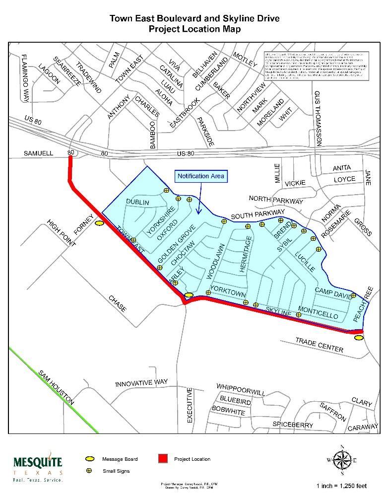
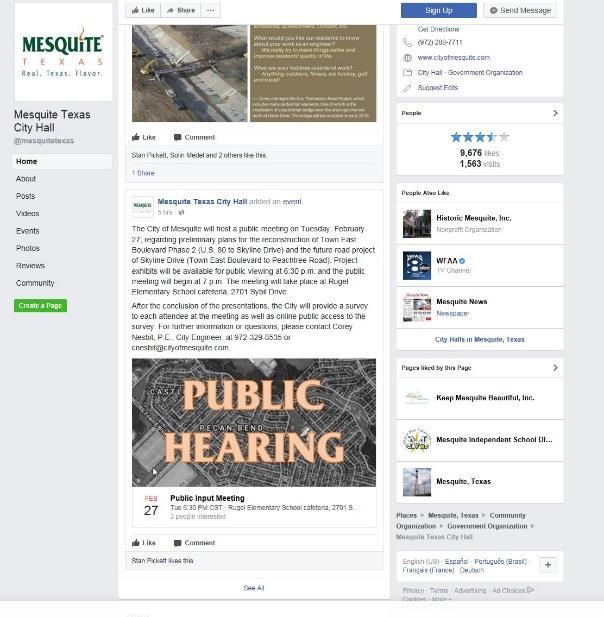
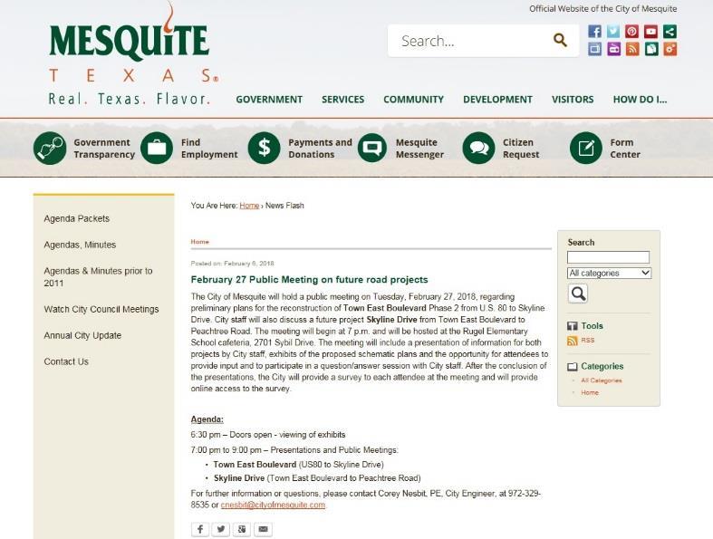
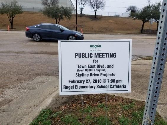
3 PUBLIC NOTIFICATION & INPUT PROCESS Notices Mailed to 1,100 Homes Adjacent to Projects. Signs at Every Street & Message Boards on Major Streets. City website, Facebook, Twitter, Nextdoor app, Mesquite News Article and Mainstream Newsletter (included with utility bills). Real. Texas. Service.

4
5 PUBLIC NOTIFICATION & INPUT PROCESS Public Meeting February 27 th 6:30pm to 9:00pm. Survey Will be Mailed to Adjacent Homes & Online for Entire City. Deadline to Complete Survey is March 23, City websites will have all the information presented tonight, detailed schematics of various options, video of tonight's meeting, summary of survey results, traffic impact analysis, etc. Staff to Compile Public Input & Survey and Present to City Council (April 2018). Council will Request Citizen Input at City Council Meeting.
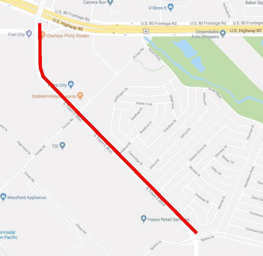
6 PUBLIC MEETING TOWN EAST BOULEVARD (US80 TO SKYLINE DRIVE) Two Segments: 1. US80 to Forney Road 2. Forney Road to Skyline Drive Real. Texas. Service.
7
8 TOWN EAST BOULEVARD (US80 TO SKYLINE DRIVE) Tentative Schedule: April 2018-City Council Decision on Design March 2018 to September 2018 Finish Design October-December 2018 Bidding Project February 2019 Start Construction Summer 2020 Finish Construction Real. Texas. Service.
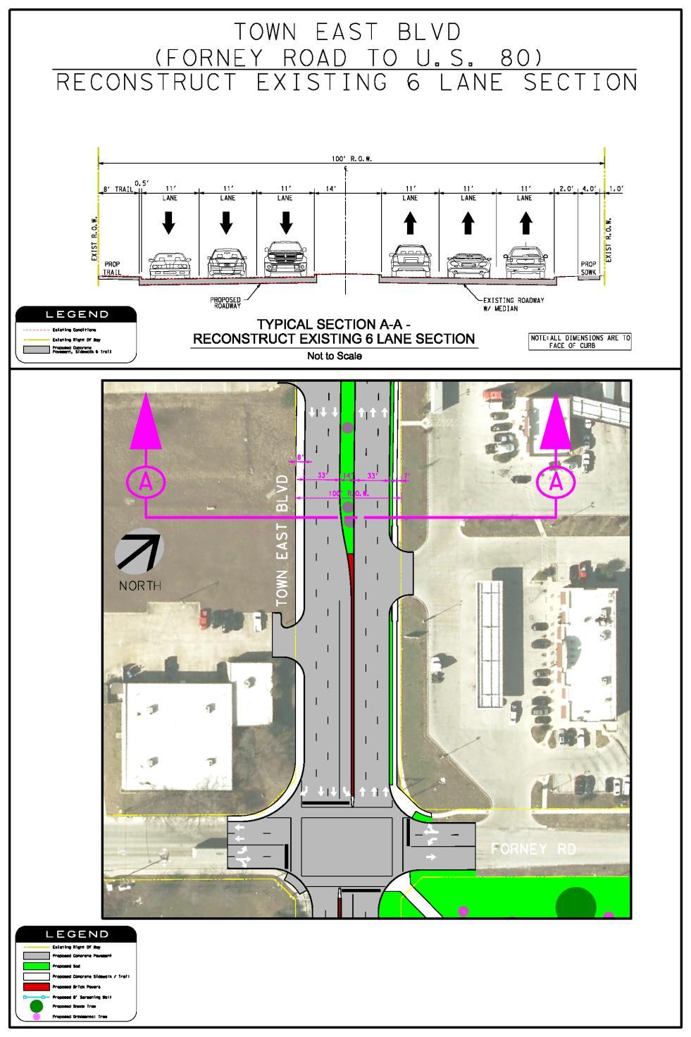
9 TOWN EAST BOULEVARD (US80 TO SKYLINE DRIVE) Segment 1 - US80 to Forney Road Maintain Existing 6-Lane Configuration with 8-foot Trail on West Side of Road Constraints: 100-foot wide right-of-way Higher Traffic Volumes Industrial / Commercial Land Use Real. Texas. Service.
10
11
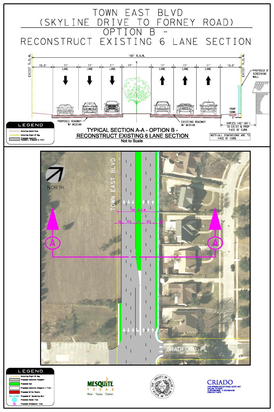
12 TOWN EAST BOULEVARD (US80 TO SKYLINE DRIVE) Segment 2 Forney Road to Skyline Drive Option A: 4-Lanes with Median & Amenities Option B: 6-Lanes with Median Constraints: 100-foot wide right-of-way Lower Traffic Volumes than Segment 1 Industrial verses Residential Land Use Real. Texas. Service.
13 TOWN EAST BOULEVARD (US80 TO SKYLINE DRIVE) Segment 2 - Forney Road to Skyline Drive Option A: 4-Lanes with Median & Amenities ADVANTAGES Moves Heavy Truck Traffic Away from Homes (reduces vibration & noise; improves pedestrian safety). More Room for Amenities (Trail, Landscaping, Screening Wall). Lower Speeds. Lower Cost. Real. Texas. Service. DISADVANTAGES Fewer Traffic Lanes.
14
15
16 TOWN EAST BOULEVARD (US80 TO SKYLINE DRIVE) Segment 2 - Forney Road to Skyline Drive Option B: 6-Lanes with Median (Existing Configuration) ADVANTAGES More Lanes DISADVANTAGES Truck Traffic Closer to Homes (more vibration & noise, less pedestrian safety). Less Room for Amenities (No Trail, No Landscaping-Sod Only). Higher Speeds than Option A. Higher Cost. Real. Texas. Service.
17
18
19 TOWN EAST BOULEVARD (US80 TO SKYLINE DRIVE) Questions - Answers and Citizen Input Real. Texas. Service.
20 5-Minute Break Real. Texas. Service.
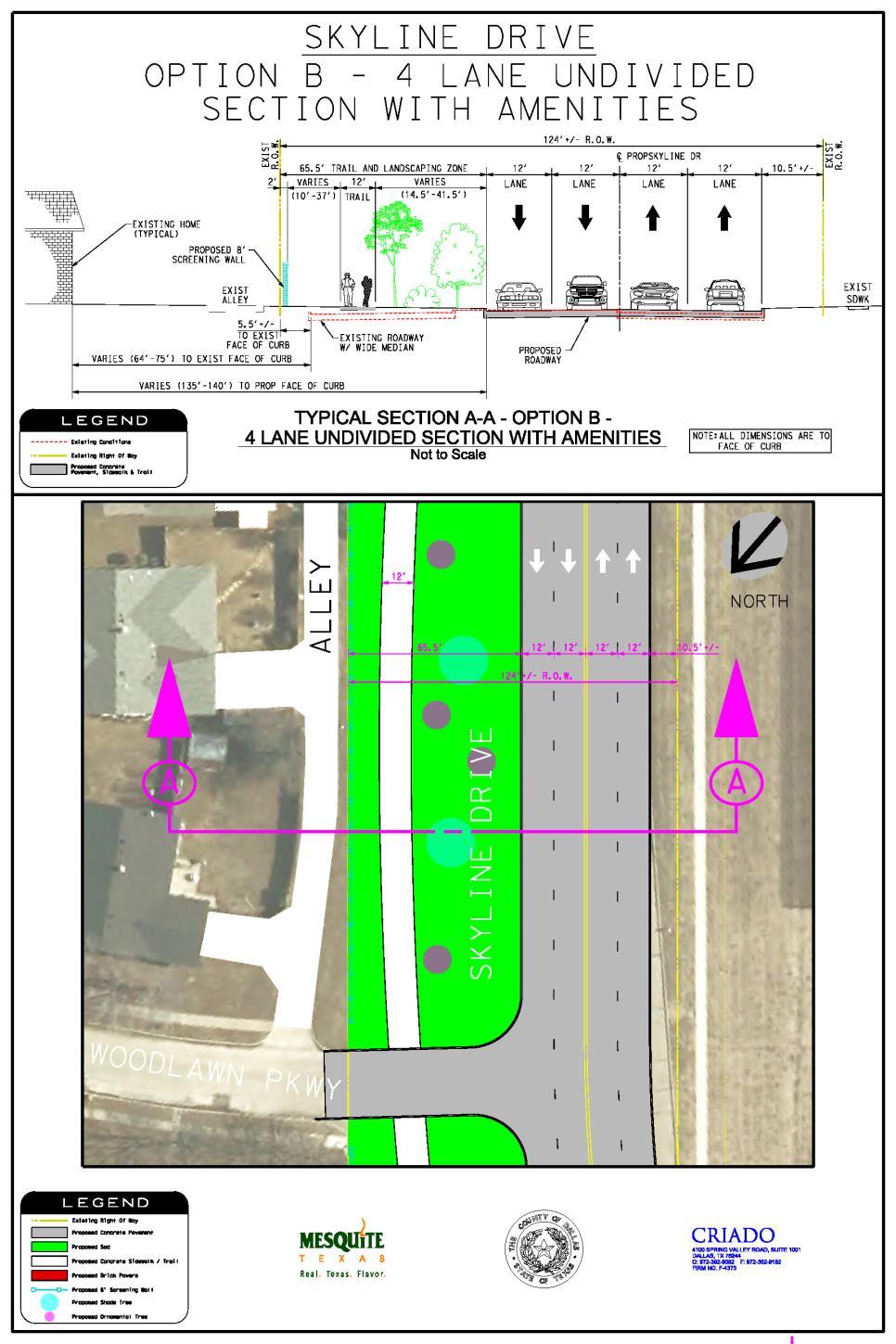
21 PUBLIC MEETING Skyline Drive (Town East Boulevard to Peachtree Road) Four Options: Reconstruct Existing Configuration A. Three Lanes (no median-with Auxiliary Right Turn Lanes) with Amenities B. Four-Lane Undivided (no median) with Amenities C. Four-Lane Divided (with median) with Amenities
22 Skyline Drive (Town East Boulevard to Peachtree Road) Constraints & Considerations: 124-foot very wide right-of-way Low Traffic Volumes Mixed Industrial - Residential Land Use
23 Skyline Drive (Town East Boulevard to Peachtree Road) Reconstruct Current Configuration 4-Lanes with Wide Median ADVANTAGES No Change DISADVANTAGES Traffic Closer to Homes Green Space in Wide Median not Easily Accessible to Pedestrian Uses Minimal Amenities Higher Speeds Real. Texas. Service.
24
25
26 Skyline Drive (Town East Boulevard to Peachtree Road) Option A - Three Lanes with Amenities (no median-but with auxiliary right turn lanes) ADVANTAGES Traffic Pushed the Maximum Distance Away from Homes Green Space Maximized and Provides Widest Buffer Between Homes and Industrial Land Uses Maximum Room for Amenities Lower Speeds Lowest Cost DISADVANTAGES Fewer Traffic Lanes
27
28
29 Skyline Drive (Town East Boulevard to Peachtree Road) Option B - Four-Lane Undivided (no median) with Amenities ADVANTAGES Traffic Pushed Away from Homes (less than Option A) Large Green Space Buffer Between Homes and Industrial Land Uses (less than Option A) Room for Amenities DISADVANTAGES Traffic Closer to Homes than Option A Higher Speeds than Option A Higher Cost
30
31
32 Skyline Drive (Town East Boulevard to Peachtree Road) Option C - Four-Lane Divided (with median) with Amenities ADVANTAGES Traffic Pushed Away from Homes (but less than Options A & B) Increases Green Space Buffer Between Homes and Industrial Land Uses (but less than Option A & B) Room for Amenities DISADVANTAGES Traffic Closer to Homes than Option A or B Higher Speeds than Option A or B Higher Cost Real. Texas. Service.
33
34
35 Skyline Drive (Town East Boulevard to Peachtree Road) Questions - Answers and Citizen Input Real. Texas. Service.
36 PUBLIC NOTIFICATION & INPUT PROCESS Public Meeting February 27 th 6:30pm to 9:00pm. Survey Will be Mailed to Adjacent Homes & Online for Entire City. Deadline to Complete Survey is March 23, City websites will have all the information presented tonight, detailed schematics of various options, video of tonight's meeting, summary of survey results, traffic impact analysis, etc. Staff to Compile Public Input & Survey and Present to City Council (April 2018). Council will Request Citizen Input at City Council Meeting.
37 Thank You for Attending!! PUBLIC MEETING TOWN EAST BOULEVARD (US80 TO SKYLINE DRIVE) & SKYLINE DRIVE (TOWN EAST BLVD. TO PEACHTREE ROAD) Real. Texas. Service.
Ocean Park Boulevard Streetscape Improvement Project Alternatives & Trade Offs
 City Council Study Session January 27, 2009 Ocean Park Boulevard Streetscape Improvement Project Alternatives & Trade Offs Scope of Work Purpose of Tonight s Meeting Review work to date and direct staff
Report. Typical Sections. City of Middleton, WI
 Report Typical Sections City of Middleton, WI December 2006 Report for City of Middleton, Wisconsin Typical Sections repared by: Traffic Associates LLC and STRAND ASSOCIATES, INC. 910 West Wingra Drive
City of Davis East Covell Corridor Plan
 Community Open House #2 January 22, 2014 6:00 8:00 p.m. Veterans Memorial Center, Club Room City of Davis Introduction The (ECCP) is a taking a comprehensive look at the existing transportation systems
Lee s Summit Road Improvement Study Public Open House June 7, 2007 Summary of Comment Card Responses
 Lee s Summit Road Improvement Study Public Open House June 7, 2007 Summary of Comment Card Responses Introduction At the Lee s Summit Road Improvement Study Public Open House held Thursday, June 7, 2007
Ocean Park Boulevard Green Street Project Alternatives & Trade Offs
 Planning Commission March 4, 2009 Ocean Park Boulevard Green Street Project Alternatives & Trade Offs Purpose of Tonight s Meeting Review concept plans and options Provide input on alternatives and trade-offs
Ocean Park Boulevard Green Street Project Community Workshop
 Ocean Park Boulevard Green Street Project Community Workshop 2.2.10 Project Objectives Community Priority: reclaim OPB for public open space. Build upon LUCE principles; neighborhood enhancement, connectivity,
Multi-Modal Facility Feasibility Study (WFC006)
") Multi-Modal Facility Feasibility Study (WFC006) Presented by: Michael Costa, Interim Transit Manager Kevin Bewsey, Senior Civil Engineer October 25, 2017 Background 1. Received a $125,000 Sustainable Transportation
Multi-Modal Facility Feasibility Study (WFC006) Presented by: Michael Costa, Interim Transit Manager Kevin Bewsey, Senior Civil Engineer October 25, 2017 Background 1. Received a $125,000 Sustainable Transportation
Scarlett Road Bridge & Road Improvements Lambton Park Community School - Gymnasium Tuesday November 28 th, 2017
 Scarlett Road Bridge & Road Improvements Lambton Park Community School - Gymnasium Tuesday November 28 th, 2017 PROJECT LOCATION 2 SCARLETT ROAD BRIDGE Constructed in 1912, the bridge carries 4 active
Tonight is for you. Learn everything you can. Share all your ideas.
 Strathcona Neighbourhood Renewal Draft Concept Design Tonight is for you. Learn everything you can. Share all your ideas. What is Neighbourhood Renewal? Creating a design with you for your neighbourhood.
Report Purpose To seek Council s approval of the Wye Road Functional Planning Study (January 2015).
.") COUNCIL MEETING Meeting Date: March 10, 2015 Agenda Item #: 13.1 Wye Road Functional Planning Study (January 2015) Report Purpose To seek Council s approval of the Wye Road Functional Planning Study (January
COUNCIL MEETING Meeting Date: March 10, 2015 Agenda Item #: 13.1 Wye Road Functional Planning Study (January 2015) Report Purpose To seek Council s approval of the Wye Road Functional Planning Study (January
IOWA HIGHWAY 58 CORRIDOR IMPROVEMENT STUDY PROJECT UPDATE NO. 1 OCTOBER 17, 2013
 IOWA HIGHWAY 58 CORRIDOR IMPROVEMENT STUDY PROJECT UPDATE NO. 1 OCTOBER 17, 2013 INTRODUCTION This web page provides information on the Iowa Highway 58 (IA 58) Corridor Improvement Study in Cedar Falls,
I-635 LBJ EAST PROJECT
 635 I-635 LBJ EAST PROJECT Transportation and Trinity River Project Committee 9 June 2014 TxDOT Dallas District Dallas County, Texas CSJ: 2374-01-137, 2374-02-053 Agenda I-635 LBJ East Project Overview
City of Memphis On-Street Parking Modification Guidelines
 City of Memphis Effective Date: December 1, 2013 Bicycle/Pedestrian Program 125 N. Main Street Memphis, TN 38103 (901) 576-6710 www.bikepedmemphis.com City of Memphis Executive Summary It is current practice
City of Fairfax, Virginia City Council Work Session
 City of Fairfax, Virginia City Council Work Session Agenda Item # 4b City Council Meeting 6/2/2015 TO: FROM: SUBJECT: ISSUE(S): SUMMARY: FISCAL IMPACT: RECOMMENDATION: ALTERNATIVE COURSE OF ACTION: RESPONSIBLE
SH 68. Meeting with Affected Property Owners September 9, 2014
 SH 68 Meeting with Affected Property Owners September 9, 2014 SH 68 US 83/I-2 TO US 281/I-69C Meeting with Affected Property Owners (MAPO) September 9, 2014 Agenda Open Meeting with Affected Property Owners
Fairview and Main Local Streets Improvement Plan
 PIM#2 Summary Report Meeting Format Date & Time: Location: Address: Prepared By: Community Open House August 11, 2016 5:30 p.m. 7:30 p.m. Red Lion Hotel 1800 W. Fairview Avenue, Boise Stephanie Borders,
Tonight is an opportunity to learn about the Study and ask questions of the Study Team members.
 Exhibit 1 Welcome Second Open House Tonight is an opportunity to learn about the Study and ask questions of the Study Team members. A first Public Open House was held on September 18th, 2013 which presented
Feasibility Study of Pedestrian Crossings Along Route 7, East of Cascades Parkway and West of Dranesville Road. October 3, 2017
 Feasibility Study of Pedestrian Crossings Along Route 7, East of Cascades Parkway and West of Dranesville Road October 3, 2017 Study Area (area within a ¼-mile radius of the study intersections) Route
Project Description Form 8EE
 Project Description Form 8EE Basic Project Information Submitting Jurisdiction/Agency: Town of Dumfries Project Title: Route 1 (Fraley Blvd) Widening: Brady's Hill Road to Dumfries Road Project Location:
City of Madison, East Johnson Street North Baldwin Street to First Street Local Street Dane County
 City of Madison, East Johnson Street North Baldwin Street to First Street Local Street Dane County Public Involvement Meeting Thursday, April 28, 2016 6 to 8 P.M. Lapham Elementary School 1045 E. Dayton
City of Beverly Hills North Santa Monica Blvd Reconstruction. Community Meeting Presentation September 30 and October 1, 2015
 City of Beverly Hills North Santa Monica Blvd Reconstruction Community Meeting Presentation September 30 and October 1, 2015 1 Project Description Complete reconstruction of boulevard (pavement, curbs,
Purple Line Extension Community Meeting
 Purple Line Extension Community Meeting August 22, 2016 Agenda Introductions Meeting Goals Project Overview and Schedules Proposed Memorandum of Agreement Overview Stay in Touch! Q & A Meeting Goals Provide
122 Avenue: 107 Street to Fort Road
 : 107 Street to Fort Road November 24, 2015 4:30 8:00 p.m. Meeting Purpose Summarize project work completed to date Share results of public input from Phase 1 Share the draft concept plan and proposed
Brighton Boulevard Public Input Summary December 2015
 Brighton Boulevard Public Input Summary December 2015 The final design-focused public meeting for the Brighton Boulevard Redevelopment Project was held as a part of the larger North Denver Cornerstone
RM 620/RM 2222 CONNECTOR (BYPASS) STATUS REPORT RM 620/2222 STATUS
 STATUS REPORT RM 620/2222 STATUS") RM 620/RM 2222 CONNECTOR (BYPASS) STATUS REPORT January 25, 2017 RM 620/2222 BYPASS - INTRODUCTION Because of the enormous traffic demand at the RM 620/2222 intersection, TxDOT searched for a way to relieve
RM 620/RM 2222 CONNECTOR (BYPASS) STATUS REPORT January 25, 2017 RM 620/2222 BYPASS - INTRODUCTION Because of the enormous traffic demand at the RM 620/2222 intersection, TxDOT searched for a way to relieve
Board of Supervisors February 27, 2017
 : Traffic Analysis Results & Draft Conceptual Plan Board of Supervisors February 27, 2017 Transportation Solutions Building Better Communities Presentation Overview Background Summary of Traffic Analysis
West Dimond Blvd Upgrade Jodhpur Street to Sand Lake Road
 West Dimond Blvd Jodhpur St to Sand Lake CSS Transportation Project Summary Municipality of Anchorage Project # 05 005 Project Manager: John Smith, P.E. (MOA PM&E) Project Administrator: Julie Makela,
Ottewell Traffic Shortcutting Pilot Project
 About the project Traffic shortcutting is an issue in communities, with residents expressing concerns about safety and their quality of life. City Council has heard these concerns, and in response, has
Station Plan: Penn & 43rd Avenue
 Station Plan: Penn & 43rd Avenue This station will serve the northern portion of the Penn Avenue corridor, including the commercial node at 44th Avenue. Ridership and roadway geometry support station siting
APPENDIX G: INTERSECTION NEEDS AT OKEECHOBEE BOULEVARD
 APPENDIX G: INTERSECTION NEEDS AT OKEECHOBEE BOULEVARD INTERSECTION NEEDS AT SR 7 and OKEECHOBEE BOULEVARD SR 7 Extension Project Development and Environment (PD&E) Study From Okeechobee Boulevard (SR
CURRENT ORIGINAL REFERENCE SECTIONS. (Typical Section) (Typical Section) The Parade Island Bay : Concept Option Summary Sheets.
 (Typical Section) The Parade Island Bay : Concept Option Summary Sheets.") ORIGINAL (Typical Section) CURRENT (Typical Section) 3,900 3,000 2,000 1,500 3,100 1,600 3,100 1,500 2,000 2,500 3,900 3,000 1,800 600 2,000 3,000 3,000 2,000 600 1,800 2,500 Existing Planting Traffic
ORIGINAL (Typical Section) CURRENT (Typical Section) 3,900 3,000 2,000 1,500 3,100 1,600 3,100 1,500 2,000 2,500 3,900 3,000 1,800 600 2,000 3,000 3,000 2,000 600 1,800 2,500 Existing Planting Traffic
Building Great Neighbourhoods BELLEVUE AND VIRGINIA PARK
 Building Great Neighbourhoods BELLEVUE AND VIRGINIA PARK This is Meeting 2 Unfortunately, some residents in Bellevue and Virginia Park received the wrong information for this public open house (Meeting
TRANSPORTATION COMMISSION Agenda Staff Report
 TRANSPORTATION COMMISSION Agenda Staff Report Agenda Item No. 5.a DATE: JULY 31, 2014 TO: FROM: SUBJECT: TRANSPORTATION COMMISSION COMMUNITY DEVELOPMENT DEPARTMENT - PLANNING DRAFT OLYMPIC CORRIDOR PREFERRED
PROPOSED BICYCLE AND PEDESTRIAN FACILITY Vicinity of Route 123/I-495 Interchange Tysons, Fairfax County, Virginia
 PROPOSED BICYCLE AND PEDESTRIAN FACILITY Vicinity of Route 123/I-495 Interchange Tysons, Fairfax County, Virginia PRELIMINARY ENGINEERING REPORT Prepared for: Prepared by: July 2017 Table of Contents 1
Caltrans Sloat Boulevard Pedestrian Safety Project Response to Community Questions, Comments & Concerns
 Caltrans Sloat Boulevard Pedestrian Safety Project Response to Community Questions, Comments & Concerns Revised: May 10, 2016 The California Department of Transportation (Caltrans) is planning various
JANUARY 2017 STUDY UPDATE. Logan City, Cache Co., CMPO
 JANUARY 2017 STUDY UPDATE Logan City, Cache Co., CMPO Purpose of the presentation To provide an update on the status of the Study To present the Study Purpose and Need To present the results of Level 1
COMMUNITY MEETING #1 Summary
 COMMUNITY MEETING #1 Summary October 26, 2016 LOCATION: TIME: ATTENDEES: Dr. Phillips High School Cafeteria 6500 Turkey Lake Road, Orlando, FL 32819 6:00 pm to 8:00 pm 79 citizens Commissioner Scott Boyd,
Purpose + Need. Connect: Thrive: Develop: < Strengthen the spine of our regional transportation system
 Purpose + Need I-29 NW Barry Road 64/68/72 MAIN STREET Connect: < Strengthen the spine of our regional transportation system Leavenworth Road Parallel Parkway State Avenue 18th Street Expressway Shawnee
MAG Town of Cave Creek Bike Study Task 6 Executive Summary and Regional Significance Report
 Page 1 MAG Town of Cave Creek Bike Study Task 6 Executive Summary and Regional Significance Report August 1, 2012 MAG Project #481 Page 2 Task 6 Executive Summary and Regional Significance Report Introduction
Austin Avenue Bridges Project. Public Meeting Summary
 Austin Avenue Bridges Project Public Meeting Summary June 29, 2016 Red Table Safety and Connectivity Notes: 1. Would like to see forensic report evaluations 2. What is the lifespan? 3. Extend safety considerations
General Plan Circulation Element Update Scoping Meeting April 16, 2014 Santa Ana Senior Center, 424 W. 3rd Street, Santa Ana, CA 92701
 General Plan Circulation Element Update Scoping Meeting April 16, 2014 Santa Ana Senior Center, 424 W. 3rd Street, Santa Ana, CA 92701 Meeting Agenda 1. Purpose of Scoping Meeting 2. Project Overview 3.
I-20 ODESSA-MIDLAND CORRIDOR STUDY. Public Meeting for Schematic Design
 I-20 ODESSA-MIDLAND CORRIDOR STUDY Public Meeting for Schematic Design The environmental review, consultation, and other actions required by applicable Federal environmental laws for this project are being,
Southview Blvd & 3 rd Avenue Improvement Project. Public Open House December 4, to 7pm
 Southview Blvd & 3 rd Avenue Improvement Project Public Open House December 4, 2014 5 to 7pm Southview Blvd & 3 rd Avenue Public Information Meeting Agenda Presentation 5:30 to 6:15 pm Purpose of Project
Environmental Assessment Findings & Recommendations. Public Hearing November 13, 2014
 Environmental Assessment Findings & Recommendations Public Hearing November 13, 2014 Welcome! Welcome and Introductions Project and Environmental Assessment Overview Public Comments Adjourn Purpose of
Application of a Complete Street
 Application of a Complete Street Southbend to Prima Vista Update May 14, 2018 Meeting Agenda Perspective and History Public input received Typical sections being considered Presentation of the 2-lane master
Military Road Safety Improvements
 Military Road Safety Improvements 26 th Road North to 31 st Street North SUMMARY OF DATA REVIEW AND PRELIMINARY RECOMMENDATIONS Prepared for: Department of Environmental Services Traffic Engineering and
MTP BICYCLE ELEMENT UPDATE. November 2017
 MTP BICYCLE ELEMENT UPDATE November 2017 TIME FOR AN UPDATE Bicycle Element adopted in July 2008 Almost 10 years old Many planned facilities have been implemented 10 years more experience in planning,
Public Information Meeting. Orange Camp Road. Dr. Martin Luther King Jr. Beltway to I-4. Presented by: Volusia County August 2, 2018
 Public Information Meeting Orange Camp Road Dr. Martin Luther King Jr. Beltway to I-4 Presented by: Volusia County August 2, 2018 1 Project Goals To improve the operations and safety for Orange Camp Road
Casablanca Boulevard & GO Station Access
 Casablanca Boulevard & GO Station Access Class Environmental Assessment STAKEHOLDER WORKSHOP Thursday September 27th, 2018 5:30PM 8:00PM 1 WORKSHOP PURPOSE Provide an overview of the Design Alternatives
Water Street Promenade Engineering and Design Services
 Preliminary Design Presentation Parking & Traffic Safety Committee Water Street Promenade Engineering and Design Services July 16,2014 November 3, 2016 Education / Infrastructure / Innovation 1 Project
Frequently Asked Questions
 Why is this roadway needed? Can't SR 50, University Boulevard and Aloma Avenue be widened instead of building this road? The need for this roadway was identified and determined through the East Orange
City of Sammamish. Welcome. Issaquah-Fall City Road Improvements Project Phase I Design: 242nd Avenue SE to Klahanie Drive SE
 Welcome Welcome to the third community meeting for the Issaquah-Fall City Road Improvements Project. AGENDA 6:00 p.m. Welcome and sign-in 6:10 p.m. Presentation 6:50 p.m. Open house Learn about the roadway
Transform I-66. Chief Engineer Garrett W. Moore, P.E. July 12, 2018
 Transform I-66 Chief Engineer Garrett W. Moore, P.E. July 12, 2018 Transform 66: Program Goals Improve multimodal mobility by providing diverse travel choices in a cost-effective manner Enhance transportation
Citizen Advisory Committee (CAC) Meeting #5 West Anaheim Youth January 27, 2016
 Meeting #5 West Anaheim Youth January 27, 2016") Citizen Advisory Committee (CAC) Meeting #5 West Anaheim Youth January 27, 2016 1 Project Team City: Jonathan Borrego, AICP Planning Manager Susan Kim, AICP Principal Planner Gustavo Gonzalez, AICP Associate
Citizen Advisory Committee (CAC) Meeting #5 West Anaheim Youth January 27, 2016 1 Project Team City: Jonathan Borrego, AICP Planning Manager Susan Kim, AICP Principal Planner Gustavo Gonzalez, AICP Associate
DRAFT. Corridor study. Honeysuckle Road. October Prepared for the City of Dothan, AL. Prepared by Gresham, Smith and Partners
 DRAFT Corridor study Honeysuckle Road October 2017 Prepared for the City of Dothan, AL Prepared by TABLE OF CONTENTS SECTION I... 1 STUDY SUMMARY... 1 INTRODUCTION... 1 CONCLUSIONS... 5 SECTION II... 7
El Camino Real Specific Plan. TAC/CAC Meeting #2 Aug 1, 2018
 El Camino Real Specific Plan TAC/CAC Meeting #2 Aug 1, 2018 Land Use Alternatives Goals and Tradeoffs Parks & open space Housing Retail & services Civic spaces Parking Community gathering spaces 3 Alternatives
Telegraph Avenue Complete Streets DRAFT Recommendations. Oakland Public Works Department September 11 and 13, 2014 Open Houses
 Telegraph Avenue Complete Streets DRAFT Recommendations Oakland Public Works Department September 11 and 13, 2014 Open Houses Presentation Overview What are complete streets? What problem are we trying
Building Great Neighbourhoods LANSDOWNE
 Building Great Neighbourhoods LANSDOWNE We are here today to Explain how the City is investing in improving your neighbourhood and how your neighbourhood will be improved to meet current City standards.
Access Location, Spacing, Turn Lanes, and Medians
 Design Manual Chapter 5 - Roadway Design 5L - Access Management 5L-3 Access Location, Spacing, Turn Lanes, and Medians This section addresses access location, spacing, turn lane and median needs, including
Agenda. Citizen Advisory Committee. CSAH 101 (CSAH 62 to Hutchins Drive) City of Minnetonka May 29, :00 pm
 City of Minnetonka May 29, :00 pm") Citizen Advisory Committee CSAH 101 (CSAH 62 to Hutchins Drive) City of Minnetonka May 29, 2012 3:00 pm Agenda 1. Introductions 2. Project Overview 3. Role of Citizen Advisory Committee 4. Citizen Advisory
Citizen Advisory Committee CSAH 101 (CSAH 62 to Hutchins Drive) City of Minnetonka May 29, 2012 3:00 pm Agenda 1. Introductions 2. Project Overview 3. Role of Citizen Advisory Committee 4. Citizen Advisory
Water Street Promenade. Engineering and Design Services. Public Information Meeting No. 2. Education / Infrastructure / Innovation. Maplewood Avenue &
 Public Information Meeting No. 2 Water Street Promenade Maplewood Avenue & Engineering and Design Services Adjacent Areas July 16,2014Portsmouth, NH May 10, 2016 Education / Infrastructure / Innovation
Frequently Asked Questions
 Frequently Asked Questions Business US 190 in Copperas Cove From Avenue D to Constitution Drive What is access management? A. Access Management is a growing effort by government agencies to improve how
Executive Summary Route 30 Corridor Master Plan
 Route Corridor Master Plan Project Overview The Route Corridor Master Plan is a coordinated multimodal transportation and land use plan for the entire stretch of Route through East Whiteland Township,
PEABODY SQUARE RECONSTRUCTION PROJECT
 FINAL DESIGN PRESENTATION HEARING Thursday April 23, 2015 with Peabody City Council Peabody, Massachusetts 6:00 PM PEABODY SQUARE RECONSTRUCTION PROJECT 239 LITTLETON ROAD, SUITE 3, WESTFORD, MA 01886
FEEDBACK SURVEY #2: WHO PARTICIPATED
 Attachment 2 - Summary of Public Opinion Survey Results Attachment 2 FEEDBACK SURVEY #2: WHO PARTICIPATED Online for public input from December 13, 2016 to May 4, 2017 Promoted through 30,000 flyers, sharing
Bay to Bay Boulevard Complete Streets Project
 Bay to Bay Boulevard Complete Streets Project Dale Mabry Highway to Bayshore Boulevard February 08, 2018 Photo Source: Tampa Bay Times Alessandra Da Pra Meeting Format Introduction Resurfacing Information
A CHANGING CITY. of Edmonton, it is essential that it reflects the long-term vision of the City.
 A CHANGING CITY By the year 2040, Edmonton will be home to more than 1 million people. To accommodate growth and support a healthy and compact city, we need a new approach to development/redevelopment
Active Transportation Facility Glossary
 Active Transportation Facility Glossary This document defines different active transportation facilities and suggests appropriate corridor types. Click on a facility type to jump to its definition. Bike
Public Workshop #2. September 14, 2016
 Public Workshop #2 September 14, 2016 Agenda Welcome Project Overview Where We Have Been Alternatives for State Street Land Use Street Design Next Steps 2 Project Overview Create a Vibrant State Street
PRESENTATION OUTLINE
 November 8, 2017 PRESENTATION OUTLINE Regional Express Lanes Network Purpose/Benefits of Express Lanes 95 Express Phase 3C Project Video and Overview 95 Express Phase 3C Schedule 2 SOUTH FLORIDA REGIONAL
Planning Study SR 976. Project Advisory Team Meeting May 24, 2017
 ` SR 976 BIRD ROAD/SW 40TH STREET FROM SR 821/HEFT TO SR 5/US-1 Miami-Dade County, Florida FPID No.: 434845-4-22-01 Planning Study Project Advisory Team Meeting May 24, 2017 1 Agenda Introductions Project
Columbia Pike Implementation Team (CPIT) Meeting
 Meeting") Columbia Pike Implementation Team (CPIT) Meeting November 30, 2010 Agenda Introductions / Purpose of Meeting Review of project goals Multimodal project: 10% street design between the curbs Discussion Multimodal
Columbia Pike Implementation Team (CPIT) Meeting November 30, 2010 Agenda Introductions / Purpose of Meeting Review of project goals Multimodal project: 10% street design between the curbs Discussion Multimodal
2014/2015 BIKE ROUTE PLAN 83 AVENUE PROTECTED BIKE LANE
 About the Project 2014/2015 BIKE ROUTE PLAN The City of Edmonton is planning a major bike route on the south side of Edmonton. This bike route is one part of a plan to provide citizens with transportation
Draft Traffic Calming Policy Paper
 Draft Traffic Calming Policy Paper What is Traffic Calming The term traffic calming is defined differently throughout the United States. The Institute of Transportation Engineers, an international educational
Appendix A-K Public Information Centre 2 Materials
 Appendix A-K Public Information Centre 2 Materials Our Rapid Transit Initiative Make an impact on the future of transit Join the discussion on Rapid Transit in London You re invited to a Public Information
Project Team Project Background Project Improvements Proposed Construction Approach Traffic Impact and Mitigation Next Steps Questions/Comments
 Project Team Project Background Project Improvements Proposed Construction Approach Traffic Impact and Mitigation Next Steps Questions/Comments 1 City of Beverly Hills Samer Elayyan, Project Manager Mark
MASTER BICYCLE AND PEDESTRIAN PLAN
 VILLAGE OF NORTHBROOK MASTER BICYCLE AND PEDESTRIAN PLAN DRAFT PLAN OPEN HOUSE May 2, 2018 AGENDA 1. Community Engagement 2. Vision and Goals 3. General Structure of Plan 4. Recommendations Overview 5.
Frequently Asked Questions (FAQ)
") Frequently Asked s (FAQ) Study Process... 2 Rapid Transit Service and Operations... 5 Public Consultation... 8 Business Impacts... 8 Design and Property Impacts... 9 Construction Impacts...12 Traffic,
Frequently Asked s (FAQ) Study Process... 2 Rapid Transit Service and Operations... 5 Public Consultation... 8 Business Impacts... 8 Design and Property Impacts... 9 Construction Impacts...12 Traffic,
APPENDIX D LEVEL OF TRAFFIC STRESS METHODOLOGY
 APPENDIX D LEVEL OF TRAFFIC STRESS METHODOLOGY 01 WHAT IS LEVEL OF TRAFFIC STRESS? When people bicycle on roadways, they encounter varying levels of stress from traffic. A quiet residential street with
City of Homewood Transportation Plan
 City of Homewood Transportation Plan Prepared for: City of Homewood, Alabama Prepared by: Skipper Consulting, Inc. May 2007 TABLE OF CONTENTS INTRODUCTION... 1 BACKGROUND INFORMATION... 1 EXISTING TRANSPORTATION
Preliminary Design of Wayzata Boulevard Improvements(CSAH 112)
") Project Area Map 6 COUNTY 112 COUNTY Preliminary Design of Wayzata Boulevard Improvements(CSAH 112) Public Open House Open House To Do List: Sign in Visit with Hennepin County staff and design team Learn
Project Area Map 6 COUNTY 112 COUNTY Preliminary Design of Wayzata Boulevard Improvements(CSAH 112) Public Open House Open House To Do List: Sign in Visit with Hennepin County staff and design team Learn
Fleur Drive Reconstruction
 Fleur Drive Reconstruction October 29, 2018 1 Agenda: Fleur Drive Reconstruction Project Scope & Cost Overview Fleur Drive Cross Section Elements - Travel Lane Widths - Sidewalk Widths - Parkway Widths
J Street and Folsom Boulevard Lane Conversion Project (T ) Before and After Traffic Evaluation
 Before and After Traffic Evaluation") J Street and Folsom Boulevard Lane Conversion Project (T15125400) Before and After Traffic Evaluation Prepared by Transportation Division June 2014 Executive Summary On February 12, 2013, the City of Sacramento
J Street and Folsom Boulevard Lane Conversion Project (T15125400) Before and After Traffic Evaluation Prepared by Transportation Division June 2014 Executive Summary On February 12, 2013, the City of Sacramento
REPORT. Engineering and Construction Department
 REPORT COMMUNITY SERVICES COMMITTEE MEETING DATE: JUNE 11, 2013 FROM: Engineering and Construction Department DATE: May 24, 2013 SUBJECT: Great Lakes Boulevard Mini Roundabout LOCATION: Great Lakes Boulevard
Chapter 3 DESIGN SPECIFICATIONS
 Brampton PathWays Planning and Design Guidelines 27 Chapter 3 DESIGN SPECIFICATIONS 3.1 CLASS 1 MULTI-USE PATH Off-road multi-use trails are the backbone of the Brampton PathWays Network. They are typically
T10:2012 Site Category 1a) T10:2012 Site Category 1b) Railway Level Crossing Approach Traffic Signal Approach Event Code F Event Code E
 T10:2012 Site Category 1b) Railway Level Crossing Approach Traffic Signal Approach Event Code F Event Code E") T10:2012 Site Category 1a) Railway Level Crossing Approach Event Code F T10:2012 Site Category 1b) Traffic Signal Approach Event Code E Traffic signals Crosswalk T10:2012 Site Category 1c) Pedestrian Crossing
T10:2012 Site Category 1a) Railway Level Crossing Approach Event Code F T10:2012 Site Category 1b) Traffic Signal Approach Event Code E Traffic signals Crosswalk T10:2012 Site Category 1c) Pedestrian Crossing
Governance and Priorities Committee Report For the July 2, 2015 Meeting
 CITY OF VICTORIA For the July 2, 2015 Meeting To: Governance and Priorities Committee Date: From: Subject: Brad Dellebuur, A/Assistant Director, Transportation and Parking Services Executive Summary The
Owl Canyon Corridor Project Overview and Summary
 Owl Canyon Corridor Project Overview and Summary December 22, 2008 The Owl Canyon corridor (generally the connection between the I-25 / Larimer County Road 70 interchange and the US 287 / Larimer County
2014/2015 BIKE ROUTE PLAN 83 AVENUE PROTECTED BIKE LANE
 About the Project The City of Edmonton is planning a major bike route on the southside of Edmonton. The Strathcona Bike Route will connect the communities of Strathcona, Garneau and the University area,
Alternative Traffic Calming Methods
 Alternative Traffic Calming Methods In-street Pedestrian Crossing Sign Cost: approximately $300 per sign not including the installation cost Advantages of in-street pedestrian crossing signs 1. Typically
Thank you for attending
 Improving mobility safety comfort WELCOME Thank you for attending The purpose of this meeting is to: Learn about the project Prioritize potential walking and biking improvements on Snelling Ave Gather
RESIDENTIAL TRAFFIC CALMING PROGRAM
 RESIDENTIAL TRAFFIC CALMING PROGRAM CITY OF ALEXANDRIA, KENTUCKY Prepared For: Safety & Public Works Departments 1 Table of Contents CITY OF ALEXANDRIA... 3 RESIDENTIAL TRAFFIC CALMING PROGRAM... 3 INTRODUCTION...
Golden s Plan. For the Highway 6 & 93 Corridor
 Golden s Plan For the Highway 6 & 93 Corridor Purpose of the Study Accommodate regional traffic needs on Highways 6 and 93, as defined by the Northwest Quadrant Feasibility Study. Find a solution that
Classification Criteria
 SCHEDULE D TO RECOMMENDED OFFICIAL PLAN AMENDMENT NO. 40 SCHEDULE C-4 Road Criteria Criteria Traffic Service Objective Land Service/Access Typical Daily Traffic Volume Flow characteristics Travel Speed
EXECUTIVE SUMMARY... vii 1 STUDY OVERVIEW Study Scope Study Area Study Objectives
 Contents EXECUTIVE SUMMARY... vii 1 STUDY OVERVIEW... 1-1 1.1 Study Scope... 1-1 1.2 Study Area... 1-1 1.3 Study Objectives... 1-3 2 EXISTING CONDITIONS... 2-1 2.1 Existing Freeway Conditions... 2-4 2.1.1
ALBERTA AVENUE WHAT WE HEARD REPORT BUILDING GREAT NEIGHBOURHOODS
 ALBERTA AVENUE WHAT WE HEARD REPORT BUILDING GREAT NEIGHBOURHOODS FEBRUARY 2019 EXECUTIVE SUMMARY Starting in 2019, Alberta Avenue will see the replacement and enhancement of its aging collector and local
NORTH HIGHLAND LAKE ROAD PROJECT
 NORTH HIGHLAND LAKE ROAD PROJECT The purpose of this special newsletter is to inform the residents of Flat Rock about the facts concerning the proposed N. Highland Lake Road Project and clarify some misconceptions.
Public Involvement Outreach Requirements for Public Information Open House Meeting: C.N , HSIP-5003(12) 132 nd and West Center Road, Omaha
 132 nd and West Center Road, Omaha") To: NDOR Environmental From: Randy McCart, HDR Date: 4 April 2017 RE: Public Involvement Summary Report, HSIP-5003(12) 132 nd and West Center Road, Omaha; C.N. 22629 Public Involvement Outreach Requirements
To: NDOR Environmental From: Randy McCart, HDR Date: 4 April 2017 RE: Public Involvement Summary Report, HSIP-5003(12) 132 nd and West Center Road, Omaha; C.N. 22629 Public Involvement Outreach Requirements
Plant City Walk-Bike Plan
 Plant City Walk-Bike Plan Plant City Commute Mode Share 2.2% 1.4% 2.9% Drove alone 10.2% Carpooled Public transportation (0.1%) Walked Used a Bike (0.4%) 82.9% Taxicab, motorcycle, or other means Worked
Traffic Control Inspection Checklist Segment:
 Traffic Control Inspection Checklist Segment: Simon Contractors Simon Contractors Originator: Description Reviewed by: Initials Date Distribution: Traffic Quality Manager, Site Assistant Traffic Manager