Bicycle and Pedestrian Advisory Committee, Monthly Meeting
|
|
|
- Meagan Potter
- 5 years ago
- Views:
Transcription
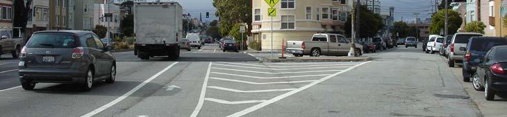
1 Bicycle and Pedestrian Advisory Committee, Monthly Meeting Thursday, November 15, 2012; 5:30 7:30 pm Oakland City Hall, Sgt Daniel Sakai Hearing Room (aka Hearing Room 4), Second Floor Attendees: Ann Killebrew, Brian Toy, Carol Levine, Chris Hwang, Chris Kidd, Jason Patton, Jennifer Stanley, Rebecca Saltzman, Tom Willging, Jonathan Bair, Jamie Parks, Ina Gerhard, Sheara Cohen, Mike Jones, Kenya Wheeler Approval of Meeting Minutes The October meeting minutes were approved. Latham Square Design Review (see attachments) Jamie Parks, Senior Transportation Planner with the Oakland DOT, introduced the design concept for the reconfiguration of Latham Square (where Telegraph St and Broadway meet in DT). The project is supposed to enhance the pedestrian experience and improve the overall functioning and safety of the intersection. Jamie shared examples of similar projects in NYC, Chicago and SF, where new plazas were created by reconfiguring intersections. This is often done without curb removal by limiting vehicle access, changing surface treatments and using low cost re used material. There are around 70 examples in NYC alone. The main advice, based on the experience in those cities, is not to make permanent changes right away, instead to get input from the public first on the concept and initial reversible changes. Also, to ensure that money for maintenance will be available once improvements are in place. For that the city is already in touch with the DT Business Association. This is the first project of this kind in Oakland. It started in 2004 with Measure B funds for the re design of Telegraph St (Streetscape project) and Latham Square. Other locations are supposed to follow with this concept of streets as public spaces to transform Oakland into Barcelona. The concept proposes to close the NB left turn from Broadway to Telegraph and the SB connection from Telegraph at 16 th to Broadway, make Telegraph one way SB between 17 th and 16 th, to create a car free plaza separated by moveable planters. All curbs and the median along Broadway will remain. The B shuttle and AC Transit line on Telegraph will be rerouted. Feedback and suggestions: Exciting project! What about bike access and impact on bike circulation as bikes cannot continue NB on Telegraph? Suggestions: Provide left turn pocket for bikes from Broadway; bike path through the square; buffered (contraflow?) bike lane or cycle path on Telegraph. Discussion about parking and one way versus two way traffic on Telegraph; two way option for 16 th and Telegraph should be evaluated. Extend plaza treatment further across 16 th and Telegraph. Can we see cross section of Broadway? Bike travel on Broadway approaching 14 th is difficult.
2 Maintenance and vandalism will be an issue. Street furniture would have to be removed at night. What about raised concrete area to create an elevated plaza? Bike access not so important. This should be a destination, not a connection. Provide educational info on parklets and other things. Consider lighting at night and sun or lack thereof during the day in design and choice of materials. BPAC s ongoing input is welcome. Volunteers are: Rebecca, Chris, Dave, Jonathan, Carol, and Kenya. Telegraph Ave, 16 th to 20 th Sts, Bikeway Design Review Jason provided background on the Telegraph Ave Streetscape project from Broadway to 20 th. The project started in 2004 and went to Council in It originally included a lane reduction and wider sidewalks, but no bike lanes. There was also property owner encroachment happening that had to be addressed. Bike lanes were added in 2008 and approved by Council with 10 travel lane width on Telegraph and a bike corral at NB 19 th. Because of the somewhat complicated project history the presented configuration is probably as good as it gets. Comments/questions: Can connection from shoulder bike lane to bike lane pocket at 19 th St be dashed or pavement marker Bike Merge Ahead be provided? (Striping as proposed is preferred b/c it leaves greater flexibility for cyclists to transition from shoulder bike lane to bike lane pocket when it is safe. There will be sign Begin Right Turn Lane Yield to Bikes. ) Issue with signal at 19 th St crosswalk that is not timed. Cars turning right NB onto Telegraph at 19 th frequently do not stop at crosswalk. Now there is a push button and all ped phase but not yet a countdown signal. DOT is working to fix this problem. Taxi stand and other issues make the whole area problematic, especially during events at the Fox Theater. Is there any way to get rid of the right turn lane at 19 th and to direct WB drivers to take 20 th or 27 th Sts instead of 19 th? (This would require revisiting the traffic study and would potentially hold up the project.) BPAC Calendar/Agenda for 2013 (see attachment) Jennifer presented a spreadsheet listing the 2012 agenda topics, comparing what was in the 2012 framework and made it on the agenda and what did not, what is working and what is not working (for example regular updates on Construction and Redevelopment projects; policy discussion of issues not taken care of by anyone). Question: How does BPAC want to proceed? Chris mentioned the Agenda Subcommittee that is working on an info package describing what the BPAC is, who can attend etc. BPAC still does not have good geographic representation of all parts of Oakland. She emphasized that everyone can submit agenda items. Jason mentioned that the Bike/Ped Program will present its work during 2012 at the next meeting in December and next year s work plan will be introduced in January Feedback and suggestions: We have done a good job of covering a variety of topics in all parts of Oakland.
3 Presentation of before and after data with collision analysis. (City will soon have better bike/ped collision analysis data based on counts at 36 intersections and will share that info once available.) Learn more about what other cities are doing, especially adjacent, connecting cities such as Alameda, Emeryville, and Berkeley. Presentation of bike/ped work students are doing. How is DOT approaching development and prioritization of traffic calming requests? On Street Bay Trail Wayfinding Signage Plan This agenda item was tabled; to be revisited at the next meeting. Announcements a) Biketopia: November 16, celebrate EBBC s 40 th anniversary. b) Measure 1B is at 66.53%. c) Oakland Department of Transportation is tweeting d) The following three Highway Safety Improvement Program (HSIP) projects are funded: o Market Street bike lanes o Bike lanes at Adeline and Market Sts o I didn t get the third one... e) Rebecca Saltzman to be sworn in at BART board meeting, December 20 th at 9 am. f) OAK Bike Plan to be re affirmed at November 27 th Public Works committee meeting; Jason to send out further details. Attachments Latham Square Design handouts Latham Plaza Building Something Out of Something (Powerpoint presentation) BPAC calendar handout


4 Latham Plaza Building Something Out of Something Streets are Public Places Look beyond traffic service function Recognize transportation facilities and services affect community life Public health Cultural resources Housing Natural environments Jamie Parks, AICP City of Oakland DOT = Department of Livability New York City Cities increasingly see MANY uses for the public ROW 1


5 New York City New York City New York City New York City 2


6 San Francisco San Francisco San Francisco Latham Square Iconic Intersection Intersection of prominent corridors Historic architecture Cathedral Building Rotunda Building Rotunda Building Gateway to Uptown 3


7 Latham Square Confusing Intersection Complex turning movements Poor pedestrian connectivity Usable pedestrian space limited Latham Square/Telegraph Streetscape Project design began in 2004 Measure B funded Numerous compromises and setbacks 95% plans complete as of Fall 2012 $2M pricetag Latham Square Latham Square New traffic signal combining 15 th and Telegraphace limited Widens SB Telegraph to 2 lanespace limited 4


8 Latham Square Latham Square Removes 2 existing crosswalksmited Removes 5 existing trees and adds 5 new treesited Latham Square Latham Square Re-imagined Build on existing assets Increase pedestrian space and connectivity Reduce driver confusion Increase Cathedral Building accessibility Adds new pedestrian spacece limited 5


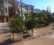
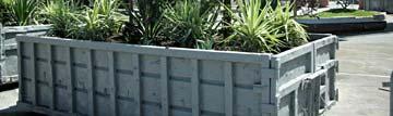
9 Latham Pilot Plaza Latham Pilot Plaza Flexible multi-purpose space Latham Pilot Plaza Latham Pilot Plaza Public art Movable planters Food trucks Tables and chairs Flexible multi-purpose space Net increase in on-street parking 6
10 Latham Pilot Plaza Latham Pilot Plaza Increased bike parking Maintain emergency access to Rotunda Building Latham Pilot Plaza Summary Installed on temporary basis Phased permanence Minimal external impacts anticipated Improved traffic flow on Broadway Increased on-street parking capacity No loss of access/delivery zones Provides flexible, community-oriented space Grass-roots programming Encourage frequent activity Ensure on-going maintenance Improves transit and auto flow along Broadway 7


11 Making it Work Next Steps Stakeholder engagement and collaboration Questions? Thank you! Jamie Parks Complete Streets Program Manager City of Oakland (510)

 Fixed Re-purposed Industrial Planters (Typ.")
12 Potential Food Truck Use 16TH ST Moveable Re-purposed Industrial Planters at both ends of Special Use Lane Bike Corral Stain on Existing Asphalt Emergency Access & Special Use & Fire Access Lane Existing Curb TELEGRAPH ONE WAY Moveable Tables & Chairs (Typ.) Temporary Public Art Installations BROADWAY 15TH ST (N) Trees in 36 boxes (Typ.) Existing Tree To Remain (Typ.) Fixed Re-purposed Industrial Planters (Typ.) Potential Temporary Stage Location for Performances N DRAFT November 12, 2012 Latham Square Pavement to Parks Concept Oakland, CA c d + a C O M M U N I T Y + D E S I G N + ARCHITECTURE
; gateway to the emerging Uptown neighborhood and entertainment district;")

 increases economic development potential; (2) saves existing")

13 Latham Square Plaza Pilot Preliminary Project Concept Project Objective Latham Square is one of the most prominent and architecturally important intersections in the City of Oakland, with several unique features: located at the intersection of two of the most significant streets in Oakland (Telegraph Avenue and Broadway); gateway to the emerging Uptown neighborhood and entertainment district; flanked by the Rotunda and Cathedral Buildings, two of the best local examples of early 20 th century architecture. Despite this prime location, Latham Square is currently dominated by automobile traffic due to the need to serve trips from both Broadway and Telegraph Avenue, and the awkward angle of the intersection. The Plaza Pilot seeks to build on Latham Square s significance by creating an enhanced pedestrian space through a low-cost trial that: (1) increases economic development potential; (2) saves existing trees; (3) improves private automobile and transit operations; and (4) enhances transportation safety. Project Summary Pedestrian Plaza Convert existing Telegraph Avenue roadbed south of 16 th Street to pedestrian-only space through the use of temporary surface treatments and perimeter planters/bollards. Use low-cost, temporary materials, similar to the New York City DOT in its successful pedestrian plaza program, and subsequently by SFMTA s Pavement to Parks program. Attractive planters will separate the pedestrian plaza from adjacent street traffic. Flexible space will be provided for a range of urban design enhancements, including outdoor art, seating, and landscaping. San Francisco's Pavement to Parks Program has successfully transformed intersections through trial installations, such as Guerrero Park. New York City s plazas serve as an important showcases for local artists, such as this exhibit on Broadway.

14 Traffic Operations Close Telegraph Avenue to automobile traffic between 16 th Street and Broadway. Convert Telegraph Avenue to one-way southbound between 16 th Street and 17 th Street with angled parking, in order to maintain full access to all properties along Telegraph Avenue. Conversion will require installation/removal of several signs, but will not require geometric modifications to the street. Remove the traffic signal at Telegraph Avenue/16 th Street from operation, and bag the signal heads per standards for inoperable signals. Close the median opening on Broadway that currently allows northbound left-turns onto Telegraph Avenue. Install temporary New Traffic Pattern Ahead signs on Telegraph Avenue and Broadway warning drivers of the closure. Should the pilot become permanent, future changes could include: Convert 16 th Street to two-way traffic to restore two-way operations on Telegraph Remove the existing traffic signal at 16 th Street/Telegraph Avenue. Continue landscaping across Broadway median opening connecting the two existing islands to create a single contiguous median in Broadway. See attached concept drawing for additional details. Potential Pilot Benefits Iconic gateway to Uptown. Aesthetically appealing pedestrian space for residents, visitors, and local business customers. Preserve existing street tree canopy (proposed 2006 re-configuration would remove most existing street trees). Space for additional bike parking in a high demand area. Unique opportunity for outdoor art installations. Improved traffic operations and safety by removing a skewed intersection with a history of head-on and broadside collisions (statistically likely to cause serious injuries). Improved transit operations for AC Transit and Free B Shuttle service on Broadway. Low cost (compared to 2006 re-configuration) by eliminating need to alter existing curbs. New York City DOT pedestrian plaza program has reinvigorated iconic locations through low-cost urban design treatments to create attractive pedestrian space.
15 Oakland BPAC 2012 Agendas: Topics discussed and omitted Date Topic 1 Topic 2 Topic 3 Topic 4 Topic 5 Not on agenda 1/19/12 TDA projects: possibilities 2/16/12 BPAC officer nominations 3/15/12 BPAC officer elections 4/19/12 5/17/12 Bi annual bike project status overview Chair's annual report on previous year 6/21/12 Resurfacing overview Officer Huy Nyugen, OPD bike patrol Broadway bikeway design review TDA projects: recommended list Oakland Traffic Calming Plan, Joe Wang, TSD BTWD report back Aaron Weinstein, BART, on new car designs Bike/Ped Program one year plan TDA projects: refined list E 12th St bikeway draft design review AC Transit, Network Structure In street bike parking draft designs BPAC training; DEC District 1 projects Bike/ped program one year plan (presented in January); Redevelopment Update: Central District Measure B Reauthorization SeeClickFix Bikeway striping update DEC District 2 projects BRT Update, AC Transit Bi annual bike project status overview (continued from April) 40th St project update Redevelopment Update: West Oakland Adeline St bike lane design East Bay Greenway DEC District 3 projects Ordinance re: Complete Streets Redevelopment Update: Broadway, MacArthur, San Pablo 7/19/12 progress report on installation of citywide bike wayfinding signs Central Estuary Implementation Guide BPAC packet (new member, by laws, minutes) HSIP grant application BPAC training; DEC District 4 projects 8/16/12 West Oakland Specific Plan About NACTO 9/20/12 10/18/12 11/15/12 Report back on PWA / bike community meeting Bi annual bike project status overview BPAC calendar for the coming year 14th St Bikeway design concepts review Shattuck Ave Bikeway design review Shattuck/52nd St intersection redesign review New Google and DIT web map apps Bicycle Master Plan City Council reaffirmation Policy forum (topic tbd); Redevelopment Update: Central City East Bike/ped collision analysis; DEC District 5 projects BFC campaign discussion Traffic signal prioritization Redevelopment Update: Coliseum Latham Sq Design Telegraph Ave bikeway design review 12/20/12 Form BTWD subcommittee Policy Forum (topic tbd) DEC District 7 projects Bay Trail Wayfinding sign plan DEC District 6 projects outlined=planned items discussed bold=proposed recurring item italics=recurring item held in other month 11/15/12
16 Status of presentations on requested (or staff recommended) topics General topics mentioned at the Nov 2011 meeting: Other funding deadlines/grants Specific topics mentioned at the Nov 2011 meeting: E12th St bikeway design Other topics: Adeline St design/buffered bike lane detail Policy forum re: ped signals Broadway bikeway design SeeClickFix Presentations of broader interest (could be like BPAC training) In street bike parking Google map of Oakland bike facilities 35th Ave final bikeway design Shattuck Ave design review Parklets On street Bay Trail signage plan crosswalk signalization update on bike corrals and parklets Madison/Oak/8th/9th Sts 35% design plans design review Oakland's draft bicycle facilities design manual Complete Streets Bike wayfinding sign plans (misc) Caldecott projects
City of Oakland, Bicyclist & Pedestrian Advisory Commission Minutes from the July 21, 2016 meeting City Hall, Hearing Room 3
 City of Oakland, Bicyclist & Pedestrian Advisory Commission Minutes from the July 21, 2016 meeting City Hall, Hearing Room 3 Meeting agenda at http://www2.oaklandnet.com/oak056329 Meeting called to order
5:30 1 Introductions, appointment of note taker (5 minutes) Ad
 Ad") DALZIEL BUILDING. 250 FRANK H. OGAWA PLAZA. SUITE 4344. OAKLAND. CALIFORNIA. 94612 Public Works Agency TEL: (510) 238-3466 Transportation Planning & Funding Division FAX: (510) 238-7415 Bicycle and Pedestrian
DALZIEL BUILDING. 250 FRANK H. OGAWA PLAZA. SUITE 4344. OAKLAND. CALIFORNIA. 94612 Public Works Agency TEL: (510) 238-3466 Transportation Planning & Funding Division FAX: (510) 238-7415 Bicycle and Pedestrian
Minutes: A motion was made to approve minutes from both the July and August BPAC meetings. That motion was approved.
 Oakland BPAC 9/20/12 Attendees: Ann Killebrew, Carol Levine, Chris Hwang, Chris Kidd, Dave Campbell, Jason Patton, Jennifer Stanley, Liza Pratt, Midori Tabata, Robert Prinz, Ryan Chan, Tom Willging, Ade
Tonight is for you. Learn everything you can. Share all your ideas.
 Strathcona Neighbourhood Renewal Draft Concept Design Tonight is for you. Learn everything you can. Share all your ideas. What is Neighbourhood Renewal? Creating a design with you for your neighbourhood.
Oakland Bicycle and Pedestrian Advisory Committee, September 19, 2013 Meeting
 Oakland Bicycle and Pedestrian Advisory Committee, September 19, 2013 Meeting Attendees: Brian Toy, Chris Hwang, Chris Kidd, Daniel Schulman, Dave Campbell, Jason Patton, Jennifer Stanley, Midori Tabata,
Bicycle and Pedestrian Advisory Committee (BPAC) November 21, 2013
 November 21, 2013") Bicycle and Pedestrian Advisory Committee (BPAC) November 21, 2013 OVERALL LAND USE CONCEPT Overall Broadway Valdez District: 95.5 acres (35.1 acres right-of ways + 60.4 acres developable land) Plan Subareas:
Bicycle and Pedestrian Advisory Committee (BPAC) November 21, 2013 OVERALL LAND USE CONCEPT Overall Broadway Valdez District: 95.5 acres (35.1 acres right-of ways + 60.4 acres developable land) Plan Subareas:
Notes from BPAC Meeting January 20, 2011
 tes from BPAC Meeting January 20, 2011 Attendees: Brian Toy, Chris Hwang, Dave Campbell, Jason Patton, Jennifer Stanley, Jonathan Bair, Kassie Rohrbach, Rebecca Saltzman, Rick Rickard, Robert Raburn, Ron
Approval of Meeting Minutes: The September minutes were approved.
 Bicycle and Pedestrian Advisory Committee, Monthly Meeting Thursday, October 18, 2012; 5:30 7:30 pm Oakland City Hall, Sgt Daniel Sakai Hearing Room (aka Hearing Room 4), Second Floor Attendees: Ann Killebrew,
Welcome! San Jose Avenue Open House August 25, 2015
 Welcome! San Jose Avenue Open House August 25, 2015 Vision Zero The City and County of San Francisco adopted Vision Zero San Francisco Vision Zero High Injury Network as a policy in 2014, committing an
Oakland Pedestrian Master Plan Oakland Pedestrian Plan Draft Recommendations Chapter Outline
 EISEN LETUNIC T R A N S P O R T A T I O N, ENVIRO N M E N TA L A N D URBAN PLANNIN G MEMORANDUM To Oakland Pedestrian Plan Technical Advisory Committee & Pedestrian Advisory Group From Victoria Eisen Date
San Jose Transportation Policy
 San Jose Transportation Policy Protected Intersections in LOS Policies to Support Smart Growth Presented by: Manuel Pineda City of San Jose Department of Transportation Bay Area Map San Francisco Oakland
THE ALAMEDA CONCEPT DESIGN COMMUNITY MEETING 3. A Plan for The Beautiful Way JANUARY 28, 2010
 CONCEPT DESIGN COMMUNITY MEETING 3 JANUARY 28, 2010 AGENDA INTRODUCTION COMMUNITY INPUT ROADWAY STUDIES STREETSCAPE DESIGN STATIONS DISCUSSION SUMMARY AND DISCUSSION NEXT STEPS CLOSE INTRODUCTION SCHEDULE
Richmond-Adelaide Cycle Tracks
 Public Drop-In Event Richmond-Adelaide Cycle Tracks June 25, 2018 12:00 p.m. 3:00 p.m. 4:30 p.m. 7:30 p.m. Metro Hall, Rotunda 55 John Street 1 Purpose of Event In Scope Communicate an update about the
CONNECTIVITY PLAN. Adopted December 5, 2017 City of Virginia Beach
 CONNECTIVITY PLAN Adopted December 5, 2017 City of Virginia Beach CONTENTS 1.0 Background & Purpose... 2 2.0 Existing Inventory & Analysis... 3 ViBe District Existing Walking Conditions... 4 3.0 ViBe District
Broad Street Bicycle Boulevard City Council Study Session Summary
 Broad Street Bicycle Boulevard City Council Study Session Summary Overview: On August 15 th, 2017, a City Council Study Session was held to invite community input and request City Council guidance on a
Major Bike Routes 102 Avenue Workshop April 21, 2015
 Major Bike Routes 102 Avenue Workshop April 21, 2015 Our Purpose Today Provide context on how Major Bike Routes fit into Edmonton s future Share information on what we heard in our last phase, and how
Protected Bike Lanes in San Francisco Mike Sallaberry SFMTA NACTO Workshop - Chicago IL
 Protected Bike Lanes in San Francisco Mike Sallaberry SFMTA 10 14 2011 NACTO Workshop - Chicago IL San Francisco 2 nd Highest Density in the U.S. 47 square miles Mild Climate Market Population ~810,000
AGENDA. 6:00 1 Roll Call/Determination of Quorum/Introductions (5 minutes)
") CITY OF OAKLAND DALZIEL BUILDING. 250 FRANK H. OGAWA PLAZA. SUITE 4344. OAKLAND. CALIFORNIA. 94612 Public Works Department TEL: (510) 238-3466 Transportation Planning & Funding Division FAX: (510) 238-7415
CITY OF OAKLAND DALZIEL BUILDING. 250 FRANK H. OGAWA PLAZA. SUITE 4344. OAKLAND. CALIFORNIA. 94612 Public Works Department TEL: (510) 238-3466 Transportation Planning & Funding Division FAX: (510) 238-7415
Community Meeting February 27, 2007 Dorchester Avenue Transportation & Streetscape Improvements Action Plan February 27, 2007
 Community Meeting Tonight s Agenda 6:00 Introductions South Boston/Dot Ave Improvement Study Background 6:15 Consultant Introductions Review of Scope and Schedule Review of Proposed Corridor Wide Guidelines
Outreach Approach RENEW SF served as the primary liaison with the North Beach community; the Chinatown. Executive Summary
 Executive Summary Executive Summary The Columbus Avenue Neighborhood Transportation Study s objective is to identify changes to transportation infrastructure and policies that could enhance the livability
Ann Arbor Downtown Street Plan
 1 Ann Arbor Downtown Street Plan Public Workshop #1 We know that. 2 Public right-of-way (streets, sidewalks, and alleys) make up 30% of the total District area of downtown. Streets need to provide mobility
SAN FRANCISCO MUNICIPAL TRANSPORTATION AGENCY
 THIS PRINT COVERS CALENDAR ITEM NO. : 11 DIVISION: Sustainable Streets BRIEF DESCRIPTION: SAN FRANCISCO MUNICIPAL TRANSPORTATION AGENCY Approving traffic modifications on Twin Peaks Boulevard between Christmas
APPENDIX A: Complete Streets Checklist DRAFT NOVEMBER 2016
 APPENDIX A: Complete Streets Checklist DRAFT NOVEMBER 2016 Complete Streets Checklist MetroPlan Orlando s Complete Streets Checklist is an internal planning tool for staff to further implementation of
FOLSOM-HOWARD STREETSCAPE OVERVIEW
 FOLSOM-HOWARD STREETSCAPE OVERVIEW SoMa residents should have the same kinds of amenities that other neighborhoods have. The Folsom- Howard Streetscape Project will make SoMa more livable by making it
REGIONAL BICYCLE AND PEDESTRIAN DESIGN GUIDELINES
 REGIONAL BICYCLE AND PEDESTRIAN DESIGN GUIDELINES November 16, 2011 Deb Humphreys North Central Texas Council of Governments Bicycle and Pedestrian Advisory Committee Snapshot of the Guide 1. Introduction
HARRISON STREET/OAKLAND AVENUE COMMUNITY TRANSPORTATION PLAN
 HARRISON STREET/OAKLAND AVENUE Community Workshop #4: Draft Plan Review December 3, 2009 D E S I G N, C O M M U N I T Y & E N V I R O N M E N T INTRODUCTIONS Key Project Staff: Alisa Shen, Project Manager,
UPTOWN REGIONAL BIKE CORRIDORS PROJECT SAN DIEGO ASSOCIATION OF GOVERNMENTS
 UPTOWN REGIONAL BIKE CORRIDORS PROJECT SAN DIEGO ASSOCIATION OF GOVERNMENTS SUMMARY REPORT: COMMUNITY UPDATE MEETING February 6, 2014 6 8:30 p.m. Roosevelt Middle School Library 3366 Park Blvd, San Diego
NEWMARKET UPHAM S CORNER
 SOUTH STATION Planning Initiative NEWMARKET UPHAM S CORNER COLUMBIA ROAD (P) FOUR CORNERS/GENEVA Working Advisory Group (WAG) Meeting #5 TALBOT AVENUE MORTON STREET BLUE HILL AVE/CUMMINS HWY (P) RIVER
TLC GRANT K / WATER STREETSCAPE ENHANCEMENTS WILL HANDSFIELD, AICP TRANSPORTATION DIR, GEORGETOWN BID
 TLC GRANT K / WATER STREETSCAPE ENHANCEMENTS Applied Fall 15 Awarded Winter 15/ 16 Notice to Proceed Spring 16 Completion Summer 16 Community Outreach Ongoing WILL HANDSFIELD, AICP TRANSPORTATION DIR,
BALBOA AREA: TRANSPORTATION PROJECTS & PLANNING
 BALBOA AREA: TRANSPORTATION PROJECTS & PLANNING TRANSPORTATION FOR ALL AGES, ABILITIES & MEANS CHANGING PATTERNS: TRENDING TO WALKING, BIKING, TRANSIT San Francisco s Change in Number of Commuters by Mode
Lincoln Highway Streetscape Plan Concept Plan
 Lincoln Highway Streetscape Plan Concept Plan November 14, 2014 Introduction This report provides a summary of conceptual transportation, land use, and design recommendations in the Lincoln Highway Streetscape
EXECUTIVE SUMMARY. Vision
 Vision Walking and bicycling in Salt Lake City will be safe, convenient, comfortable, and viable transportation options that connect people to places, foster recreational and economic development opportunities,
Las Tunas Downtown Revitalization City Council Study Session. December 1, :00 p.m. Live Oak Park Community Center
 Las Tunas Downtown Revitalization City Council Study Session December 1, 2015 7:00 p.m. Live Oak Park Community Center AGENDA 2 Provide downtown context. Confirm project goals. Analyze three design concepts.
WELCOME. Purpose of the Open House. Update you on the project. Present a draft recommended plan. Receive your input
 WELCOME Purpose of the Open House The Town of Smiths Falls has initiated the Beckwith Street Redevelopment Plan that includes the preparation of a streetscape functional design for the renewal of Beckwith
ROUTE 81 CORRIDOR STUDY DESIGN CONCEPTS
 RT 81 Corridor Study CLINTON ROUTE 81 CORRIDOR STUDY DESIGN CONCEPTS View north on High Street, with potential improvements to the streetscape Draft Recommendations November 8 th, 2018 TOWN OF CLINTON
5:30 1 Introductions, appointment of note taker (5 minutes) Ad
 Ad") CITY OF OAKLAND DALZIEL BUILDING. 250 FRANK H. OGAWA PLAZA. SUITE 4344. OAKLAND. CALIFORNIA. 94612 Public Works Agency TEL: (510) 238-3466 Transportation Planning & Funding Division FAX: (510) 238-7415
CITY OF OAKLAND DALZIEL BUILDING. 250 FRANK H. OGAWA PLAZA. SUITE 4344. OAKLAND. CALIFORNIA. 94612 Public Works Agency TEL: (510) 238-3466 Transportation Planning & Funding Division FAX: (510) 238-7415
Saskatchewan Drive Roadway Rehabilitation and Shared-Use Path Widening
 Saskatchewan Drive Roadway Rehabilitation and Shared-Use Path Widening We are here today to present the draft plan for the Saskatchewan Drive Roadway Rehabilitation and Shared-Use Path Widening project
About the study. North Milwaukee Ave. Key goals of this study are to: Achieve Vision Zero* by. Harmonize the space and improve walkability
 About the study Key goals of this study are to: North Milwaukee Avenue is a local and regional street for multiple modes of transportation. It is officially zoned and functions as a pedestrian street southeast
Meade Street Bridge Design Alternative Study
 Meade Street Bridge Design Alternative Study Preferred Alternative Presentation Stakeholder Meeting #3 June 23, 2011 Presented by: Dan Biggs, RLA Meeting Agenda Purpose: 1. Review Meeting #2 Feedback 2.
Agenda. Overview PRINCE GEORGE S PLAZA METRO AREA PEDESTRIAN PLAN
 PRINCE GEORGE S PLAZA METRO AREA PEDESTRIAN PLAN May 28, 2008 Agenda Welcome and introductions Project overview and issue identification Planning context and strengths Design challenges and initial recommendations
Mayor s Bicycle Advisory Council. Wednesday, December 13 th, 2017
 Mayor s Bicycle Advisory Council Wednesday, December 13 th, 2017 Bicyclist Fatalities, Year to Date (January 1 November 30, 2017) - MBAC Briefing Bicyclist Fatality Statistics Year to date total, 2017
Community Task Force November 15, 2017
 Community Task Force November 15, 2017 Welcome and Introductions Project Partners Regional Transportation District (RTD) Colorado Department of Transportation (CDOT) Denver Regional Council of Governments
NJDOT Complete Streets Checklist
 Background The New Jersey Department of Transportation s Complete Streets Policy promotes a comprehensive, integrated, connected multi-modal network by providing connections to bicycling and walking trip
Public Workshop #2. September 14, 2016
 Public Workshop #2 September 14, 2016 Agenda Welcome Project Overview Where We Have Been Alternatives for State Street Land Use Street Design Next Steps 2 Project Overview Create a Vibrant State Street
Working Group Meeting
 Working Group Meeting February 6, 2018 Parks and Natural Resources Operations Building Transportation Analysis Draft Policy Framework Agenda 7:05 pm Welcome 7:10 pm Follow-up from Previous Meetings Schedule
CITY OF SLO SEEKS INPUT ON PREFERRED ALTERNATIVE FOR BROAD STREET BICYCLE BOULEVARD PROJECT
 City of San Luis Obispo, News Release DATE: August 1, 2017 RELEASE: Immediate CONTACT: Luke Schwartz (805) 781-7190 Transportation Planner-Engineer, Public Works CITY OF SLO SEEKS INPUT ON PREFERRED ALTERNATIVE
BD RESOLUTION NO RESOLUTION ADOPTING THE VISION ZERO RAMP INTERSECTION STUDY PHASE 1
 BD00 RESOLUTION NO. - RESOLUTION ADOPTING THE VISION ZERO RAMP INTERSECTION STUDY PHASE [NTIP PLANNING] FINAL REPORT WHEREAS, The Vision Zero Ramp Intersection Study Phase was recommended by Commissioner
Dowling/Beaty Cycling Route
 Public Meeting #2 Dowling/Beaty Cycling Route May 17, 2017 6:00 p.m. 8:00 p.m. Parkdale Public Library - Auditorium 1303 Queen Street West How to Participate Share your questions, ideas and concerns We
Southview Blvd & 3 rd Avenue Improvement Project. Public Open House December 4, to 7pm
 Southview Blvd & 3 rd Avenue Improvement Project Public Open House December 4, 2014 5 to 7pm Southview Blvd & 3 rd Avenue Public Information Meeting Agenda Presentation 5:30 to 6:15 pm Purpose of Project
Chapter 3: Multi-Modal Circulation and Streetscapes
 CHAPTER 3: MULTI-MODAL CIRCULATION AND STREETSCAPES Chapter 3: Multi-Modal Circulation and Streetscapes Overview Streetscape improvements have already been completed for Depot Street between Main Avenue
PRINCE GEORGE S PLAZA METRO AREA PEDESTRIAN PLAN
 PRINCE GEORGE S PLAZA METRO AREA PEDESTRIAN PLAN May 28, 2008 Agenda Welcome and introductions Project overview and issue identification Planning context and strengths Design challenges and initial recommendations
City of Oakland, Bicycle and Pedestrian Advisory Committee, Monthly Meeting
 City of Oakland, Bicycle and Pedestrian Advisory Committee, Monthly Meeting Thursday October 17, 2013 meeting Attendees: Jennifer Anderson Jenna Burton Dave Campbell, East Bay Bicycle Coalition Jeffrey
FOCUS AREA 1 - Alberta Avenue Pocket Park 3 (121 Ave and 92 St)
") FOCUS AREA 1 - Alberta Avenue Pocket Park 3 (121 Ave and 92 St) New benches Plant evergreen trees Widen existing sidewalk from 1.5m to 1.8m Marked crosswalk 1.8m wide sidewalk Add pedestrian oriented lights
FOCUS AREA 1 - Alberta Avenue Pocket Park 3 (121 Ave and 92 St) New benches Plant evergreen trees Widen existing sidewalk from 1.5m to 1.8m Marked crosswalk 1.8m wide sidewalk Add pedestrian oriented lights
In station areas, new pedestrian links can increase network connectivity and provide direct access to stations.
 The Last Mile Planning for Pedestrians Planning around stations will put pedestrians first. Making walking to stations safe and easy is important; walking will be a part of every rapid transit Accessible
AGENDA ITEM G-2 Public Works
 AGENDA ITEM G-2 Public Works STAFF REPORT City Council Meeting Date: 12/6/2016 Staff Report Number: 16-214-CC Regular Business: Approve the Oak Grove University Crane Bike Improvement Concept Plan, authorize
General Plan Circulation Element Update Scoping Meeting April 16, 2014 Santa Ana Senior Center, 424 W. 3rd Street, Santa Ana, CA 92701
 General Plan Circulation Element Update Scoping Meeting April 16, 2014 Santa Ana Senior Center, 424 W. 3rd Street, Santa Ana, CA 92701 Meeting Agenda 1. Purpose of Scoping Meeting 2. Project Overview 3.
Technical Working Group November 15, 2017
 Technical Working Group November 15, 2017 Welcome and Introductions Project Partners Regional Transportation District (RTD) Colorado Department of Transportation (CDOT) Denver Regional Council of Governments
PROJECT OVERVIEW. 20th Avenue Project Limits (Lincoln Way to Wawona St)
") PROJECT OVERVIEW In 2014, San Francisco adopted Vision Zero as City policy, with a commitment to eliminate all traffic deaths in the City by 2024. nue Project Limits (Lincoln Way to St) Collision data
PROJECT OVERVIEW In 2014, San Francisco adopted Vision Zero as City policy, with a commitment to eliminate all traffic deaths in the City by 2024. nue Project Limits (Lincoln Way to St) Collision data
2014/2015 BIKE ROUTE PLAN 83 AVENUE PROTECTED BIKE LANE
 About the Project The City of Edmonton is planning a major bike route on the southside of Edmonton. The Strathcona Bike Route will connect the communities of Strathcona, Garneau and the University area,
Active Transportation Facility Glossary
 Active Transportation Facility Glossary This document defines different active transportation facilities and suggests appropriate corridor types. Click on a facility type to jump to its definition. Bike
5 Circulation & Parking
 5 Circulation & Parking Downtown Parking & Circulation Strategy. Downtown Wayne has a somewhat disconnected system of local public streets to connect downtown with the residential neighborhoods, and primary
Exhibit 1 PLANNING COMMISSION AGENDA ITEM
 Exhibit 1 PLANNING COMMISSION AGENDA ITEM Project Name: Grand Junction Circulation Plan Grand Junction Complete Streets Policy Applicant: City of Grand Junction Representative: David Thornton Address:
Upper Market Street Bike Lane Project
 Upper Market Street Bike Lane Project 17th Street to Octavia Boulevard 6 30 2010 SAN FRANCISCO, CALIFORNIA Agenda San Francisco & Sustainable Transportation Project Goals Outreach & Coordination Project
City of Lafayette Public Meeting Agenda Downtown Street Improvement Master Plan Implementation Committee Thursday, April 21, :00 PM
 1. CALL TO ORDER 2. ROLL CALL 3. ADOPTION OF AGENDA 4. PUBLIC COMMENTS 5. OLD BUSINESS 6. NEW BUSINESS City of Lafayette Public Meeting Agenda Downtown Street Improvement Master Plan Implementation Committee
Thank you for attending
 Improving mobility safety comfort WELCOME Thank you for attending The purpose of this meeting is to: Learn about the project Prioritize potential walking and biking improvements on Snelling Ave Gather
Mineral Avenue Corridor Assessment. ITE 2017 Western District Annual Meeting San Diego, CA June 21 st
 Mineral Avenue Corridor Assessment ITE 2017 Western District Annual Meeting San Diego, CA June 21 st Biography - Aaron Heumann, PE, PTOE Currently City of Littleton Transportation Engineering Manager 24
MARTIN LUTHER KING JR. WAY
 OCTOBER 2011 40 Vision and Goals The Martin Luther King, Jr. Way Illustrative Master Plan that follows has been developed through a process of community involvement. It expresses a long term vision for
Data Analysis February to March Identified safety needs from reported collisions and existing travel patterns.
 Welcome! Thank you for participating in today s Valencia Bikeway Improvements workshop. Data Analysis February to March Identified safety needs from reported collisions and existing travel patterns. Initial
University of Victoria Campus Cycling Plan Terms of Reference. 1.0 Project Description
 University of Victoria Campus Cycling Plan Terms of Reference 1.0 Project Description The Campus Cycling Plan, a first for the University, will provide a comprehensive and coordinated approach to support
Bridgewater Complete Streets Prioritization Plan and Pedestrian Safety Assessment
 Bridgewater Complete Streets Prioritization Plan and Pedestrian Safety Assessment Presented by Luciano Rabito Manager of Complete Streets Presented to Bridgewater, MA Wednesday, April 26, 2017 6:30 P.M.
Data Analysis February to March Identified safety needs from reported collisions and existing travel patterns.
 Welcome! Thank you for participating in today s Valencia Bikeway Improvements workshop. Data Analysis February to March Identified safety needs from reported collisions and existing travel patterns. Initial
Main-McVay Transit Study: Phase 2 Options Definition and High Level Constraints Evaluation
 Main-McVay Transit Study: Phase 2 Options Definition and High Level Constraints Evaluation APRIL 2016 A collaborative study between: For Additional Information or to Comment If you would like additional
City of Charlottesville Bicycle and Pedestrian Master Plan Update
 City of Charlottesville Bicycle and Pedestrian Master Plan Update September 17, 2014 I. Welcome and meeting overview II. Project status update III. Network overview IV. Break-out groups Pedestrian Network
Northbound San Jose Avenue & I-280 Off-Ramp Road Diet Pilot Project
 Project Overview Fed by a two-lane Interstate-280 (I-280) off-ramp, high vehicular volumes and speeds are longstanding issues along San Jose Avenue. Residents in the surrounding neighborhoods have expressed
Designing Complete Streets: What you need to know
 Designing Complete Streets: What you need to know Getting from this to this. Continuous sidewalk Buffer w/trees Bicycle lane Raised median Buildings close to the street Flexibility in design Design and
Item to be Addressed Checklist Consideration YES NO N/A Required Description Complete Streets Guidelines
 Passaic County Complete Streets Checklist - Concept Development Project Name Item to be Addressed Checklist Consideration YES NO N/A Required Description Complete Streets Guidelines Existing Plans Have
Lincoln Neighborhood Corridor Plan The LiNC
 CITY OF SANTA MONICA Lincoln Neighborhood Corridor Plan The LiNC PLANNING COMMISSION September 2, 2015 COMMUNITY DESIGN + ARCHITECTURE TEAM: Community Design + Architecture Iteris Studio 111 Urban Place
City of Seattle Edward B. Murray, Mayor
 City of Seattle Edward B. Murray, Mayor Department of Transportation Scott Kubly, Director Eastlake Community Council 117 E Louisa St. #1 Seattle, WA 98102-3278 January 28, 2016 RE: Roosevelt to Downtown
Central Freeway and Octavia Circulation Study
 Central Freeway and Octavia Circulation Study Final Report Plans and Programs Committee San Francisco County Transportation Authority September 18, 2012 Presentation Outline Background and Study Purpose
The Wiggle Route in Context
 The Wiggle Route in Context In a city of hills, the Wiggle is an important route because it winds its way along the flattest streets from Market to the Panhandle, bringing residents to local parks and
Telegraph Avenue Complete Streets DRAFT Recommendations. Oakland Public Works Department September 11 and 13, 2014 Open Houses
 Telegraph Avenue Complete Streets DRAFT Recommendations Oakland Public Works Department September 11 and 13, 2014 Open Houses Presentation Overview What are complete streets? What problem are we trying
Make Lincoln Highway an economically vibrant corridor that is safe, efficient, and beautiful for local residents and visitors.
 Lincoln Highway Streetscape Plan Stakeholder Workshop #2 Handout Contents Introduction and Project Vision Planning Principles Specific Recommendations including a Proposed Typical Roadway Section Renderings
Lee s Summit Road Improvement Study Public Open House June 7, 2007 Summary of Comment Card Responses
 Lee s Summit Road Improvement Study Public Open House June 7, 2007 Summary of Comment Card Responses Introduction At the Lee s Summit Road Improvement Study Public Open House held Thursday, June 7, 2007
Safe Streets. City of Lake Forest Park. March 21, 2017
 Safe Streets City of Lake Forest Park March 21, 2017 1 01 WELCOME 2 Agenda WELCOME WHAT IS THIS PROJECT? CONTEXT DRAFT CITYWIDE PROJECTS EXERCISE INTRODUCTION 3 02 WHAT IS THIS PROJECT? 4 WHAT IS THIS
PEDESTRIAN ACTION PLAN
 ATTACHMENT 2 CITY OF SANTA MONICA PEDESTRIAN ACTION PLAN CITY OF SANTA MONICA PEDESTRIAN ACTION PLAN This page intentionally left blank EXECUTIVE SUMMARY CHAPTER 1 EXECUTIVE SUMMARY Setting the Stage
Dr. M.L. King, Jr. Street North Complete Streets Resurfacing Opportunities HOUSING, LAND USE, AND TRANSPORTATION COMMITTEE MARCH 22, 2018
 Dr. M.L. King, Jr. Street North Complete Streets Resurfacing Opportunities HOUSING, LAND USE, AND TRANSPORTATION COMMITTEE MARCH 22, 2018 What s Happening The City plans to mill and resurface Dr. M.L.
Oakland BPAC 7/17/14 5:30 7:30 pm Hearing Room 4
 Oakland BPAC 7/17/14 5:30 7:30 pm Hearing Room 4 Attendees: Carol Levine, Chris Hwang, Chris Kidd, Christina Ferracane, Fred McWilliams, Jason Patton, Jennifer Anderson, Jennifer Stanley, Kenya Wheeler,
Item No. 14 Town of Atherton
 Item No. 14 Town of Atherton CITY COUNCIL STAFF REPORT CONSENT AGENDA TO: THROUGH: FROM: HONORABLE MAYOR AND CITY COUNCIL GEORGE RODERICKS, CITY MANAGER MICHAEL KASHIWAGI, COMMUNITY SERVICES DIRECTOR MARTY
25th Avenue Road Diet Project A One Year Evaluation. Transportation Fund for Clean Air Project #05R07
 25th Avenue Road Diet Project A One Year Evaluation Transportation Fund for Clean Air Project #05R07 Submitted by: The San Francisco Municipal Transportation Agency Dan Provence May 22, 2009 EXECUTIVE
Appendix C. TRAFFIC CALMING PROGRAM TOOLBOX
 Appendix C. TRAFFIC CALMING PROGRAM TOOLBOX PHASE I...2 Do Not Enter Sign...3 One-Way Sign...4 Turn Prohibition...5 Pavement Markings...6 Speed Monitoring Trailer...7 Neighborhood Speed Watch...8 Police
Polk Streetscape Project
 What is this project? The Polk Streetscape Project is an effort to improve safety for everyone traveling on Polk Street between Union and McAllister streets. Also included in this project are paving, sewer
Pennsylvania Avenue (CR 484) Design Alternatives Study
 Design Alternatives Study") MEMORANDUM Pennsylvania Avenue (CR 484) Design Alternatives Study Prepared for: APRIL 2016 Prepared By TABLE OF CONTENTS Project Background... 2 Previous Concept... 2 Existing Conditions... 4 New Alternatives...
MEMORANDUM Pennsylvania Avenue (CR 484) Design Alternatives Study Prepared for: APRIL 2016 Prepared By TABLE OF CONTENTS Project Background... 2 Previous Concept... 2 Existing Conditions... 4 New Alternatives...
Welcome to the Open House
 Leslie Street Between 19 th Avenue and Stouffville Road Addendum to Class Environmental Assessment Study Welcome to the Open House Please sign in at the front desk. March 28, 2017 Richmond Green Sports
S T A T I O N A R E A P L A N
 The Circulation and Access Plan describes vehicle, pedestrian, and transit improvements recommended within the Concept Plan. In order to create and sustain a vibrant business district that provides pedestrian-friendly
City of Novi Non-Motorized Master Plan 2011 Executive Summary
 City of Novi Non-Motorized Master Plan 2011 Executive Summary Prepared by: February 28, 2011 Why Plan? Encouraging healthy, active lifestyles through pathway and sidewalk connectivity has been a focus
Golden Gate Park. Project Goal and Description. Lower Great Highway Facts
 PROJECT OVERVIEW Project Goal and Description The goal of the is to increase pedestrian safety and comfort along Lower Great Highway by evaluating and implementing near- and medium-term pedestrian improvements
Observations and Ideas: Toomer s Corner Streetscape Improvements
 Observations and Ideas: Toomer s Corner Streetscape Improvements AUBURN DOWNTOWN MASTER PLAN planning downtown s future August 26, 2013 Observations: Vertical Clutter at Corners 6 3 7 5 9 2 8 4 1 Excess
Lawrence Avenue Streetscape Concepts August 30, 2011
 Lawrence Avenue Streetscape Concepts August 30, 2011 Neighborhood Context Phase II: River to Western Ave. Phase I: Western Ave. to Clark St. Key Map Lawrence Ave. Existing Streetscape Conditions East of
COMMUNITY MEETING AGENDA
 COMMUNITY MEETING AGENDA Welcome and Introductions SAFE Presentation Project Presentation Priorities Feedback Next Steps Q&A Santa Cruz Avenue Corridor Study 1 Santa Cruz Avenue Corridor Study Community
Pedestrian Safety Workshop SAN FRANCISCO, CALIFORNIA
 Pedestrian Safety Workshop 02 15 2011 SAN FRANCISCO, CALIFORNIA 1 Agenda Walking in San Francisco Accomplishments and Current Pedestrian Activities Mayor s Pedestrian Safety Executive Directive Next Steps