Geographic Response Plan Map: EFL-25. Map Continued on Page: EFL-30. EFL25-01 Cape Canaveral Air Force Station Nesting Beach - South
|
|
|
- Lilian Sherman
- 5 years ago
- Views:
Transcription
 Canaveral Port Authority k!")
 Incident Command Posts!( S!")
1 r '30"W Banana River 28 30'0"N!d! White Geographic Response Plan Map: EFL-25 Point Map Continued on Page: EFL '0"W 28 30'0"N! Cactus Point a th)! er erve Map Continued on Page: EFL-26!S(!d 28 22'30"N AB 528!d [s!s( Long Point 80 37'30"W! Banana River [r!s(!d Home Point Merritt Island National Wildlife Refuge Middle Point Inter Agency Maritime Operations Center (IMOC) Canaveral Port Authority k! Banana River Aquatic Preserve!d!d AB A1A Environmentally Sensitive Areas Summer Protection Priority XXX!Å A - Protect First XX B - AB!] 520 Protect after A Areas X C - Protect after B Areas Response Methods m «Skimmer Shallow Water Skimmer!( h # Collection Point General Booming Strategy (Length in Feet) Incident Command Posts!( S!( R!( F E Staging Areas Oil Spill Risk Sites Equipment Storage Locations Tidal Inlet Protection Strategy XXX m! XXX EFL Port Canaveral - East Entrance # # 1500 F « EFL Brevard Atlantic Coast Beaches (Cape Canaveral) Bio-Socioeconomic Beach Access! Airport [y Aquaculture Aquatic Preserve/State Park [k Black Bear Habitat [z Boat Ramp!d Coast Guard [s [¼ Diving Gull/Tern Nesting Area!!Å Heliport High Recreational Beach [m!] Marina! [j Cape Canaveral Air Station Conservation Area Map Continued on Page: EFL-24! Manatee [v NERR [j [w [«!d( [x [²!!q [r National Park Naval Facility Piping Plover Power Plant Recreational Fishing Right Whale Sea Turtle Nesting Area Water Intake Wildlife Refuge EFL25-01 Cape Canaveral Air Force Station Nesting Beach - South Mangroves [² Atlantic Ocean! XXX Sea Turtle Nesting Beach µ Aquaculture Leases Federal Managed Areas State Managed Areas State Waters/County Line USCG Sector Boundary Northeast & Eastern Central Florida Area Committee Fish and Wildlife Research Institute (FWRI-FWC) Miles Sector St. Petersburg 80 30'0"W MSU Savannah Sector Jacksonville Sector Jacksonville Sector Miami 28 22'30"N
2 GRP - Oil Spill Sensitive Site Report for Sector : Jacksonville GRP Map # EFL-25 Name: Site Description: Cape Canaveral Air Force Station Nesting Beach - South Protection Priority (Season): Restricted access Spring: A Summer: A Fall: A Winter: A Site ID: Latitude (DMS): 28 27' " Longitude (DMS): 80 31' " County: Brevard Latitude (DD): Longitude (DD): SCAT Division: Brevard County Division 2 ESI Map: EFL-25 ESI Name: Cape Canaveral, Fla. NOAA Chart 11481_1 CHART Name APPROACHES TO PORT CANAVERAL USGS Quad: D5 QUAD Name: Cape Canaveral Managed Area (if applicable): Cape Canaveral Air Force Station General Location: Contacts: Shoreline Type: Beach GEOSPATIAL INFORMATION CONTACT INFORMATION EFL25-01 FL State Watch Office ; NRC ; FWC Mammal Conservation Biologist ; FWC-LE (Dispatch) ; Brevard County EOC (Director) NOAA-SSC (USCG District 7) (o) (c) (24hr); DOI - Regional Environmental Officer or ; DEP-OER RESOURCES AT RISK INFORMATION Habitat: Wildlife: Beach Sea turtles, right whale, dolphins, beach mice Threaten/Endangered Species: Sea turtles, Right whale, beach mouse Socio-Economic Resources: Staging Area Collection Points: Area Access: Spill Risk: Response Resources: OSRO/BOA RESPONSE CONSIDERATIONS PROTECTION STRATEGY INFORMATION Tidal Range (FT): Average Current (KTS): Ease of Protection: Min. Boom Length (FT): Boom Type: Booming Method: Protection Strategy: Cape Canaveral AFS may have protection strategy. Report produced by Florida FWC - Fish and Wildlife Research Institue on: Tuesday, July 02, 2013 For additional information, please contact FWC-FWRI Center for Spatial Analysis (727)
3 GRP - Oil Spill Sensitive Site Report for Sector : Jacksonville GRP Map # EFL-25 Name: Port Canaveral - East Entrance Site ID: EFL25-02 Protection Priority (Season): Spring: A Summer: A Fall: A Winter: A Site Description: Latitude (DMS): 28 24' " Longitude (DMS): 80 35' " Latitude (DD): Longitude (DD): ESI Map: EFL-25 ESI Name: Cape Canaveral, Fla. NOAA Chart 11478_1 CHART Name PORT CANAVERAL USGS Quad: D5 QUAD Name: Cape Canaveral Managed Area (if applicable): Port Canaveral General Location: GEOSPATIAL INFORMATION County: Brevard SCAT Division: Brevard County Division 2 CONTACT INFORMATION Contacts: FL State Watch Office ; NRC ; FL DEP Aquatic Preserve (Manager) or ; FWC Non-Game Biologist ; Brevard County EOC (Director) ; Port Control NOAA-SSC (USCG District 7) (o) (c) (24hr); DOI - Regional Environmental Officer or ; DEP-OER Shoreline Type: RESOURCES AT RISK INFORMATION Habitat: Wildlife: Mangroves, seagrasses, turtle nesting beach Juvenile turtles, fish, manatees, shorebirds, wading birds, breeding birds, Atlantic salt marsh snake, nesting and hatching turtles, breeding Least terns, dolphins Threaten/Endangered Species: Manatees, Leatherback and Green sea turtles (nesting and hatching), Scrub jay, gopher tortoise, indigo snake, breeding Least terns, Atlantic salt marsh snake Socio-Economic Resources: Staging Area Collection Points: Area Access: Spill Risk: Response Resources: RESPONSE CONSIDERATIONS Freddie Patrick Park, Rodney S. Ketchum Boat Ramp At mouth of harbor, deflection boom to basin boat/vehicle Clean Coast Cooperative. OSRO/BOA PROTECTION STRATEGY INFORMATION Tidal Range (FT): Average Current (KTS): Ease of Protection: Min. Boom Length (FT): 4,000 Boom Type: Booming Method: Deflection Protection Strategy: Sorbent boom on beach. 2,000' of cascading deflection boom off each jetty. Collect on beach north and south of jetties. Offshore open water recovery system. See BMP if manatees are present. Report produced by Florida FWC - Fish and Wildlife Research Institue on: Tuesday, July 02, 2013 For additional information, please contact FWC-FWRI Center for Spatial Analysis (727)
4 GRP - Oil Spill Sensitive Site Report for Sector : Jacksonville GRP Map # EFL-25 Name: Brevard Atlantic Coast Beaches (Cape Canaveral) Site ID: EFL25-03 Protection Priority (Season): Spring: A Summer: A Fall: A Winter: A Site Description: Latitude (DMS): 28 23' " Longitude (DMS): 80 35' " Latitude (DD): Longitude (DD): ESI Map: EFL-25 ESI Name: Cape Canaveral, Fla. NOAA Chart 11478_1 CHART Name PORT CANAVERAL USGS Quad: D5 QUAD Name: Cape Canaveral Managed Area (if applicable): General Location: Cape Canaveral Entrance south GEOSPATIAL INFORMATION County: Brevard SCAT Division: Brevard County Division 2 CONTACT INFORMATION Contacts: FL State Watch Office ; NRC ; FWC LE (Jacksonville) ; FWC-LE (Dispatch) ; FLDEP Aquatic Preserve (Manager) ; Brevard County EOC (Director) Brev. Co. (Beach Coord.) ; FWC Non-Game Biologist ; NOAA-SSC (USCG District 7) (o) (c) (24hr); DOI - Regional Environmental Officer or ; DEP-OER Shoreline Type: Sand beach RESOURCES AT RISK INFORMATION Habitat: Wildlife: Sandy beach Sea turtle nesting beaches, fishing resources Threaten/Endangered Species: Sea turtles (April - November), manatees, nesting Least terns Socio-Economic Resources: Staging Area Access all along A1A Collection Points: Mechanical removal from beach Area Access: boat/vehicle/atv Spill Risk: Response Resources: OSRO/BOA RESPONSE CONSIDERATIONS PROTECTION STRATEGY INFORMATION Tidal Range (FT): Average Current (KTS): Ease of Protection: Min. Boom Length (FT): Boom Type: Booming Method: NA Protection Strategy: Remove oil from high tide mark ASAP to reduce amount sinking into sand. Possible to boom some areas if not turtle season. Open water recovery system. No staging in/on sand dunes. Be aware of venomous snakes in sand dunes. Report produced by Florida FWC - Fish and Wildlife Research Institue on: Tuesday, July 02, 2013 For additional information, please contact FWC-FWRI Center for Spatial Analysis (727)
5 GRP - Oil Spill Staging Area Report for Sector : Jacksonville GRP Map # EFL-25 Facility Name: Central Basin Collection Site #3, #4 Site ID: Data Collector (Agency): Managing Agency: Physical Address: NCP 1 & NCP2 Central Basin City: Cape Canaveral State: Florida Zip Code Latitude (DMS): 28 24' " N Site Type: Staging GEOSPATIAL INFORMATION Longitude (DMS): 80 37' 6.456" W Latitude (DD): Longitude (DD): Operational Status: Water Type: Boat Launch Capability: Number of Boat Slips: Boat Ramp Surface Composition: Water Depth at End of Boat Ramp: 35' off pier Shoreline Type in Viewable Viscinity: concrete bulkhead Access Constraints: Crane Capabilities: Collection Point Capabilities: Parking Capacity for Trailers: Parking Lot Dimensions: paved to bulkhead Capable for Light or Heavy Equipment and Type: Boom Available On-Site and Length: Fuels Available: Special/Pre-Planned Events and Dates: SITE DESCRIPTION Access: Water Body Name: Number of Moorings: Wave Energy at Site: Parking Capacity for Cars: Parking Surface: ADDITIONAL AMMENITIES Water Available: 35' off pier Fire Hydrant: Pumpout Available: GENERAL INFORMATION AND COMMENTS County: Brevard Propane or Natural Gas Available Bathrooms Available: Electricity Amperage Available: Camping Facilities: Food Available: Comments: Port Authority General Manager/Contact Person: Dwight Fender Survey Type: Contact Phone #: SCAT Description: Brevard County Division 2 Hours of Operation: Number of Boat Ramps: Photo URL: Scale of Staging Area: Days of Operation: Number of Boat Ramp Lanes: Security Available and Hours On Duty: Survey Date: Report produced by Florida FWC - Fish and Wildlife Research Institue on: Tuesday, July 02, 2013 For additional information, please contact FWC-FWRI Center for Spatial Analysis (727)
6 GRP - Oil Spill Staging Area Report for Sector : Jacksonville GRP Map # EFL-25 Facility Name: Central Basin Collection Site #3, #4 Site ID: Data Collector (Agency): Managing Agency: Physical Address: NCP 1 & NCP2 Central Basin City: Cape Canaveral State: Florida Zip Code Latitude (DMS): 28 24' " N Site Type: Staging GEOSPATIAL INFORMATION Longitude (DMS): 80 36' " W Latitude (DD): Longitude (DD): Operational Status: Water Type: Boat Launch Capability: Number of Boat Slips: Boat Ramp Surface Composition: Water Depth at End of Boat Ramp: 35' off pier Shoreline Type in Viewable Viscinity: concrete bulkhead Access Constraints: Crane Capabilities: Collection Point Capabilities: Parking Capacity for Trailers: Parking Lot Dimensions: paved to bulkhead Capable for Light or Heavy Equipment and Type: Boom Available On-Site and Length: Fuels Available: Special/Pre-Planned Events and Dates: SITE DESCRIPTION Access: Water Body Name: Number of Moorings: Wave Energy at Site: Parking Capacity for Cars: Parking Surface: ADDITIONAL AMMENITIES Water Available: 35' off pier Fire Hydrant: Pumpout Available: GENERAL INFORMATION AND COMMENTS County: Brevard Propane or Natural Gas Available Bathrooms Available: Electricity Amperage Available: Camping Facilities: Food Available: Comments: Port Authority General Manager/Contact Person: Dwight Fender Survey Type: Contact Phone #: SCAT Description: Brevard County Division 2 Hours of Operation: Number of Boat Ramps: Photo URL: Scale of Staging Area: Days of Operation: Number of Boat Ramp Lanes: Security Available and Hours On Duty: Survey Date: Report produced by Florida FWC - Fish and Wildlife Research Institue on: Tuesday, July 02, 2013 For additional information, please contact FWC-FWRI Center for Spatial Analysis (727)
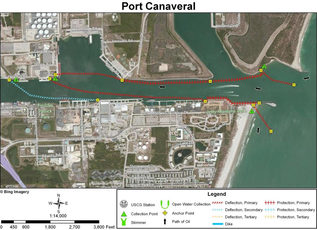
7 INLET SUMMARY SHEET SITE: Port Canaveral, Brevard County, Florida DATE AND TIME OF ORIGINAL FIELD SURVEY [TIDE]: 26 June 1994; (+3.8), Port Canaveral entrance] UPDATED: In October 2011 using imagery collected in 2010 and RANKING (DEGREE OF DIFFICULTY): C. (see ranking scale) PRINCIPAL RESOURCES AT RISK: The Atlantic green turtle and Atlantic loggerhead turtle nest on outer beaches. Manatees and Atlantic bottlenose dolphins are present. Shorebirds, wading birds, and seabirds. Marine and Port facilities; boats. For more information refer to recent ESI map and data and the GRP. PRELIMINARY PROTECTION STRATEGY: Use deflection boom to divert oil to a collection on the outer sand beach on the south side of the south jetty (CP1) and to the sand beach inside the inlet (riprap at high-tide line), adjacent to the north jetty (CP2). Use about one mile of protection boom to prevent oil from entering the first boat basin to the north and to keep oil out of riprap along the north shore. Also place protection boom along the riprap to the west of the south jetty. Deploy a line of deflection boom across the entrance to the next bay on the north side of the main inlet channel to divert oil to a collection point against the seawall of the southwest corner of Port Canaveral (CP3). Another long line of deflection boom extended obliquely across the main inlet channel that is anchored to a line of riprap at the west end of the south jetty will also deflect oil to CP3. Another line of deflection boom extended obliquely across the main inlet channel would deflect oil to the concrete/metal seawall along the north shore of the Canaveral Barge Canal (CP4). [NOTE]: The Canaveral Lock is located between Port Canaveral s West Turning Basin and the Banana River. The lock reduces the tidal-current velocities in Canaveral Harbor and can be kept closed as the final line of defense to prevent oil from entering the Banana River. OTHER COMMENTS: Hunt (1980) calculated, based on tidal prism, average current velocities at both maximum flood and ebb tides to be approximately 0.1 knots, but somewhat stronger flood currents are to be expected at times. Lots of construction is taking place in this port area. 95
8 96

9 Collection Point Description Inlet: Port Canaveral Site Name: Collection Point #1 Relative Location: Beach on south side of the south jetty. Latitude: 28 24' " N Longitude: 80 35' " W Currents: 1-3 knots flood currents running to the north during rising tides; heavy waves at times. Shoreline Description: Fine-grained sand beach. Access: Paved road to beach, 150 yards from paved road to water; parking area at Jetty Maritime Park. 97

10 Collection Point Description Inlet: Port Canaveral Site Name: Collection Point #2 Relative Location: Just south of the north jetty. Latitude: 28 24' " N Longitude: 80 35' " W Currents: Probably flood currents of about one knot on rising tide. Shoreline Description: A small fine-grained sand beach in corner; riprap at high tide line elsewhere. Access: Drive down beach; also there is a sand track behind beach that eventually leads to the beach beside the north jetty. 98

11 Collection Point Description Inlet: Port Canaveral Site Name: Collection Point #3 Relative Location: West side of Central Turning Basin. Latitude: 28 24' " N Longitude: 80 36' " W Water Depth Description: 35 depth off pier. Currents: Probably less than one knot. Shoreline Description: Concrete bulkhead/seawall. Access: Paved to bulkhead. 99

12 Collection Point Description Inlet: Port Canaveral Site Name: Collection Point #4 Relative Location: North side of Canaveral Barge Canal, about 1.8 miles inland from inlet entrance. Latitude: 28 24' " N Shoreline Description: Concrete/metal seawall. Currents: Probably considerably less than one knot. Access: Easy driving access by Dolphin Road. Longitude: 80 36' " W 100
Geographic Response Plan Map: EFL-13NW AB 608 AB 5 1 AB 68 ") 770. !Å Heliport [ Historical!Å Site!(RSeagrass! Manatee
 770. !Å Heliport [ Historical!Å Site!(RSeagrass! Manatee") ! 27 30'0"N 80 22'30"W! Geographic Response Plan Map: EFL-13NW [k Indian River - Vero Beach to Ft. Pierce Aquatic Preserve Ft. Pierce State Park [k J a c k I s l a n d 80 18'45"W [\ 27 30'0"N ]^607A ")
! 27 30'0"N 80 22'30"W! Geographic Response Plan Map: EFL-13NW [k Indian River - Vero Beach to Ft. Pierce Aquatic Preserve Ft. Pierce State Park [k J a c k I s l a n d 80 18'45"W [\ 27 30'0"N ]^607A ")
Geographic Response Plan Map: SFL-21. Map continued on: SFL-31S XXX. k Curry Hammock. SFL21-05 Grassy Key Beaches. Map continued on: SFL-20
 ! 81 0'0"W Geographic Response Plan Map: SFL-21 Map continued on: SFL-31S 80 52'30"W Arse XXX S A 24 52'30"N j Everglades National Park [] [ 24 52'30"N Florida Bay Flo Nati S 9N-01 oo Banks ock 54! Bamboo
EFL Map Continued on Page: EFL-54 FXXXEFL Nassau Sound XXX. Nassau Sound. Little Talbot. Big Talbot A1A. r rg. Ft.
 Ecological & Historic Preserve c 900 ou Nassau C ounty C l a v Du Nassau Sound Geographic Response Plan Map: EFL-55 EFL-56-06 # t k S EFL-56 F XXonXPage: ( Map Continued d Nassau Sound \ «- Bird Island
Geographic Response Plan Map: SFL-19. Map continued on: SFL-19N. Vaca Key. Hawk Channel. Reef Monitoring Site. Florida Keys.
 !!! L18-01 thel Bank en X! 46 e) igeon 24 45'0"N Bethel Bank XXX Map continued on: SFL-18 81 7'30"W 47! # 450 SFL19-04 Boot Inlet SFL19N-02 John Sawyer Bank 100 SFL19-05 Sister Creek - Boot, FL Rachel
Geographic Response Plan Map: EFL-9. Map continued on: EFL-11 #[\ [\ H u t c h i n s o n I s l a n d XXX XXX
 OUNTY r South h t. r 1200 27 15'0"N!] Map continued on: EFL-10 27 7'30"N 80 15'0"W Environmentally Sensitive Areas Summer Protection Priority A - Protect First B - Protect after A Areas XX X C - Protect
Geographic Response Plan Map: SFL-25. Map continued on: SFL-29. Lignumvitae Key. Aquatic Preserve. Lignumvitae Key Botanical.
 ! 25 0'0"N 80 45'0"W Spy Key Geographic Response Plan Map: SFL-25 Panhandle Key Panhandle Key Florida Bay Map continued on: SFL-29 Crab Keys West Key 80 37'30"W 25 0'0"N Crane Keys Crane Keys XXX j Everglades
Geographic Response Plan Map: SFL-26. Map continued on: SFL-28. Florida Keys. Wildlife and Environmental. ! k. Area. Plantation Key.
 !!!!!!!!!!!!!!!!!!!!!!!!!!!!!!!! u Cotton Key lamorada f!. ey 4550 SFL26-03 Cotton Key 82! 2750 SFL25-05 Upper Matecumbe Beach ey 25 0'0"N Map continued on: SFL-25 tic Ocean 24 52'30"N 80 37'30"W XXX 1700!
Geographic Response Plan Map: SFL-54. !d [\ AB A1A XXX. SFL54-04 Boca Raton Inlet/ Lake Boca Raton XXX. SFL Site 3.
 26 22'30"N Map continued on: SFL-55 26 15'0"N 80 7'30"W Environmentally Sensitive reas Bio-Socioeconomic Summer Protection Priority - Protect First [\ Beach ccess B - Protect after reas [m irport XXX XX
XXX. Chisolm Island Creeks. Map Continued on SC-48. Judge Island. SC49-03 Jenkins Creek/Morgan River Intersection XXX. Saint Helena Island
 w River 32 30'0"N ufort County 80 37'30"W 802 Coosaw River 250 450 SC41-05 Geographic Response SC41-03 Plan Map: Coosaw SC-49 River Chisolm Island Chisolm Island s u Map Continued on SC-41 3 (west side)
Geographic Response Plan Map: SC-41 ACE BASIN NERR. u [b. Big Island. SC47-08 Old Chehaw. River SC Bull River XXX
 32 37'30"N 80 37'30"W Geographic Response Plan Map: SC-41 Map Continued on SC-33W ACE BASIN NERR 80 30'0"W 32 37'30"N!d Old Chehaw Ashepoo Map Continued on SC-40 32 30'0"N y Schooner Channal 80 37'30"W
Geographic Response Plan Map: SC-35 Pleasant Point. Map Continued on SC-36. SC35-05 Church Flats Creek. SC35-01 Mouth of Stono River XXX.
 wood [ 34-01 ogoodoo ek 32 45'0"N Map Continued on SC-34 32 37'30"N 80 15'0"W [y [ 80 15'0"W «165 «165 Meggett SC35-04 Wadmalaw River Wadmalaw River «165 Hollywood Martins Point [ SC35-03 Oyster House
Geographic Response Plan Map: VI-7 Inset Map A567 TRUNK AND HAWKSNEST BAYS XXX. St. John. qxxxa551 - V.I. WAPA WATERINTAKE, Acropora Priority Sites
 Geographic Response Plan Map: VI-7 Inset Map Whistling Cay Virgin Islands National Park j St. John qa551 - V.I. WAPA WATERINTAKE, Great Cruz FRANK BAY # St. St. n Jo h s a om Th A554 CHOCOLATE HOLE FISH
Geographic Response Plan Map: SC-17
 79 37'30"W Geographic Response Plan Map: SC-17 79 30'0"W 33 7'30"N Charleston County 33 7'30"N 33 0'0"N 79 37'30"W [ Awendaw [j [e!d!s(!d Graham Creek FRANCIS MARION NATIONAL FOREST 450 Awendaw Creek [j
Case Study: Merritt Island National Wildlife Refuge
 Case Study: Merritt Island National Wildlife Refuge Read the case study below. As you read, complete the Case Study Notetaking worksheet. Geography Cape Canaveral is on the east coast of Florida, roughly
Geographic Response Plan Map: VI-1. Maroon Hole Annaly Bay. Hams Bluff. Bay B515 FREDERIKSTED PIER A518 - LONG POINT BAY BEACHES AND SALT POND ( ^
 Geographic Response Plan Map: VI-1 64 52'3W A512 - DAVIS BAY BEACH CARAMBOLA BEACH RESORT) Maroon Hole Annaly Hams Bluff A511 CANE BAY XXX ^7 XXX # ^ 5 4 Cane 17 45'N 17 45'N Butler Hams Caribbean Sea
Chief-Planning & Readiness USCG Sector Houston-Galveston
 Boom Efficacy During the DEEPWATER HORIZON Response LCDR Joseph J. Leonard, Jr. Chief-Planning & Readiness USCG Sector Houston-Galveston June 2011 Boom Selection Responder Skill Sets Boom Utilization Site
GOAL: Collect product flowing over Onalaska spillway to protect downstream resources C&C 250 Y Y. Looking upstream at spillway
 GOAL: Collect product flowing over Onalaska spillway to protect downstream resources BR5 Black n/a Onalaska Spillway Carry- In C&C 250 Y Y Looking upstream at spillway Implementation (Go to Aerial View)
Proposed Terrestrial Critical Habitat for the Northwest Atlantic Loggerhead Sea Turtle Population. U.S. Fish and Wildlife Service
 Proposed Terrestrial Critical Habitat for the Northwest Atlantic Loggerhead Sea Turtle Population U.S. Fish and Wildlife Service History of Loggerhead Listing (joint responsibility USFWS and NOAA Fisheries)
HARBOR INFRASTRUCTURE INVENTORIES Fairport Harbor, OH
 HARBOR INFRASTRUCTURE INVENTORIES Fairport Harbor, OH Harbor Location: Fairport Harbor is located at the mouth of the Grand River on the southern shore of Lake Erie in the city of Fairport, OH, approximately
Beach Nourishment Impact on Beach Safety and Surfing in the North Reach of Brevard County, Florida
 Beach Nourishment Impact on Beach Safety and Surfing in the North Reach of Brevard County, Florida Prepared by John Hearin, Ph.D. Coastal Engineering Vice Chairman Cocoa Beach Chapter Port Canaveral Patrick
Project Webpage:
 Project Webpage: http://nature.ly/marinesatlanticbightera Coastal Data and Full Metadata: http://easterndivision.s3.amazonaws.com/marine/sab MA/SABMACoastalEcosystems.zip Coastal Chapter: http://easterndivision.s3.amazonaws.com/marine/sab
AGENCY/ORGANIZATION OFFICE/DIVISION SECTION/SUBSECTION ACTIONS (Related to Coral Reefs) Natural Resources Planning and Management Division
 Natural Resources Planning and Management Division") AGENCY/ORGANIZATION OFFICE/DIVISION SECTION/SUBSECTION ACTIONS (Related to Coral Reefs) Broward County Environmental Protection and Growth Department Natural Resources Planning and Division Broward County
AGENCY/ORGANIZATION OFFICE/DIVISION SECTION/SUBSECTION ACTIONS (Related to Coral Reefs) Broward County Environmental Protection and Growth Department Natural Resources Planning and Division Broward County
Beach Renourishment in Jacksonville
 Beach Renourishment in Jacksonville Kevin Bodge, PhD, P.E. - Olsen Associates, Inc. 1978 Oct 2004 2000 2016 2011 Oct 2016 Coastal Duval County, FL Nassau Sound Blount Island Ft. George Inlet St. Johns
Southeast Volusia Coastal Projects Update
 Southeast Volusia Coastal Projects Update Public Works Department Coastal Division August 15, 2016 2016 Dune Walkover Re-Decking Program Completed Dune Walkovers South End 8 th Ave. New Smyrna Beach* 12
Wexford Harbour. Yachting Guide. Navigation
 Wexford Harbour Yachting Guide Navigation This document supersedes all previous editions. Approvals: Yacht Club Committee April, 2015 Wexford Board of Directors April, 2015 # Date Section Revision 1 6.5.2015
REGION 2. Eysturoy (north)
") REGION 2. Eysturoy (north) DATE OF SURVEY: October 2000 General Description of the Area including Tidal Information The region consists of the northern part of Eysturoy, within which are the coastal villages
REGION 2. Eysturoy (north) DATE OF SURVEY: October 2000 General Description of the Area including Tidal Information The region consists of the northern part of Eysturoy, within which are the coastal villages
Puget Sound Nearshore Ecosystem Restoration Project Restore America s Estuaries Conference 2012 Tampa, FL
 Restore America s Estuaries Conference 2012 Tampa, FL presented by: Theresa Mitchell, WA Dept. of Fish & Wildlife Nearshore General Investigation Change Analysis: Comparison of historical and current
HARBOR INFRASTRUCTURE INVENTORIES West Harbor, OH
 HARBOR INFRASTRUCTURE INVENTORIES West Harbor, OH Harbor Location: West Harbor is located on the southern shore of Lake Erie in the township of Catawba Island, OH about 50 miles east of Toledo, OH. Authority:
Marine Ecosystems. Aquatic Ecosystems Section 2
 Marine Ecosystems Marine ecosystems are located mainly in coastal areas and in the open ocean. Organisms that live in coastal areas adapt to changes in water level and salinity. Organisms that live in
Barge MM 46 Response Natchez, MS Lower Mississippi River Mile Marker 363
 UNCLASSIFIED Barge MM 46 Response Natchez, MS Lower Mississippi River Mile Marker 363 UNCLASSIFIED RRT Activation: Type of Product & Amount spilled: Cause of Spill: None Catalytic Cracked Clarified Oil
HARBOR INFRASTRUCTURE INVENTORIES Oak Orchard Harbor, New York
 HARBOR INFRASTRUCTURE INVENTORIES Oak Orchard Harbor, New York Harbor Location: Oak Orchard Harbor is located on the southern shore of Lake Ontario at the mouth of Oak Orchard Creek in the village of Point
HARBOR INFRASTRUCTURE INVENTORIES Muskegon Harbor, Michigan
 HARBOR INFRASTRUCTURE INVENTORIES Muskegon Harbor, Michigan Harbor Location: Muskegon Harbor is located on the east shore of Lake Michigan, 114 miles northeast of Chicago, IL. Authority: River & Harbor
Initial recovery of flora and fauna at restored mosquito impoundments in Indian River Lagoon, FL
 Initial recovery of flora and fauna at restored mosquito impoundments in Indian River Lagoon, FL Melinda Donnelly PhD Candidate, University of Central Florida Ron Brockmeyer, Linda Walters, William Greening,
GONE! Coastal Erosion Happens During Storms! Why Worry About Coastal Setbacks? Goals for Today
 RI Regulatory Setbacks & Buffers: Coastal Zone Management Issues New England Onsite Wastewater Training Program @ URI OWT 155 November 21, 2013 Goals for Today Understand the impacts of storms, coastal
Final Waterways Assets and Resources Survey Master Plan for Dredging and Beach Nourishment
 Final Waterways Assets and Resources Survey Master Plan for Dredging and Beach Nourishment For, Massachusetts Prepared For: Dennis Town Hall P.O. Box 2060 485 Main Street Dennis, MA 02660 Prepared By:
2018 Beach Preservation Project Information
 QUICK FACTS Beach Renourishment to begin late April 2018 o U.S. Army Corps of Engineers project o Project Area: 8 th St. E. to end of E. Ashley Ave. o Project Length: 2 miles o Cost: $10,900,000 o Funding:
Invasive Species. No, not aliens from outer space!
 Invasive Species No, not aliens from outer space! Next Generation Science Standards This lesson about invasive species incorporates real data and tools used by Gulf of Mexico scientists and resource managers.
Nome Harbor Page 2 of 12
 Nome Harbor Nome Harbor Page 2 of 12 Condition of Improvements 30 December 2015 Nome Harbor, Alaska (CWIS No. 010422, 012270, 072742, 087755) Authorization (1) Rivers and Harbors Act, 8 August 1917 (House
North Shore of Long Island, Feasibility Study
 North Shore of Long Island, Asharoken New York Asharoken, Feasibility Study Asharoken, NY Public Meeting June 30, 2015 US Army Corps of Engineers US Army Corps of Engineers New York BUILDING STRONG BUILDING
HARBOR INFRASTRUCTURE INVENTORIES Marquette Harbor, Michigan
 HARBOR INFRASTRUCTURE INVENTORIES Marquette Harbor, Michigan Harbor Location: Marquette Harbor is located in Marquette Bay on the south shore of Lake Superior, 160 miles west of Sault Ste. Marie, MI and
National Oceanic and Atmospheric Administration (NOAA)/ Mulberry Phosphate Trustee Council September 12, 2013
/ Mulberry Phosphate Trustee Council September 12, 2013") OYSTER REEF CREATION PROJECT DESIGN AND IMPLEMENTATION IN HILLSBOROUGH BAY, FLORIDA TAMPA BAY REGIONAL PLANNING COUNCIL AGENCY ON BAY MANAGEMENT MEETING National Oceanic and Atmospheric Administration
OYSTER REEF CREATION PROJECT DESIGN AND IMPLEMENTATION IN HILLSBOROUGH BAY, FLORIDA TAMPA BAY REGIONAL PLANNING COUNCIL AGENCY ON BAY MANAGEMENT MEETING National Oceanic and Atmospheric Administration
GEM Network; Færoe Islands Coastal Protection Plans. REGION 1. Viðoy. DATE OF SURVEY: October 2000
 REGION 1. Viðoy DATE OF SURVEY: October 2000 General Description of the Area including Tidal Information This region consists of the northern parts of Borðoy, Kalsoy, Kunoy, Svínoy as well as Fugloy. Borðoy
US Beach Nourishment Experience:
 Beach Nourishment: Introduction of new sand to the beach by truck or dredge Large beach >1 million cubic yards (100,000 dump truck loads) Funding is a combination of federal, state, local & private Also
Cat Island Chain Restoration
 Cat Island Chain Restoration 1820s Fox River Military Road Map to Fort Howard 1845 Chart of Green Bay & Fox River Cat Island Chain - 1938 Cat Island Brown County Aerial Photography, 1938 Historic Western
Surfrider s Recreational Use Survey and Marine Spatial Planning in Washington State. Gus Gates- WA Policy Manager
 Surfrider s Recreational Use Survey and Marine Spatial Planning in Washington State Gus Gates- WA Policy Manager Overview Background on MSP and Rec Study Stakeholder outreach Collaboration w/ OCNMS staff
The Sand Beaches of New Hampshire and Maine
 The Sand Beaches of New Hampshire and Maine Beach Preservation and Erosion Control Photographs provided by Joe Kelly and Steve Adams Cover photo: Reid State Park, ME Introduction The sand beaches of New
RI Regulatory Setbacks & Buffers: Coastal Management Issues
 RI Regulatory Setbacks & Buffers: Coastal Management Issues New England Onsite Wastewater Training Program @ URI OWT 155 - November 29, 2012 James Boyd - Coastal Policy Analyst Photo: October 30, 2012
BookletChart. Intracoastal Waterway Matecumbe to Grassy Key NOAA Chart A reduced-scale NOAA nautical chart for small boaters
 BookletChart Intracoastal Waterway Matecumbe to Grassy Key NOAA Chart 11449 A reduced-scale NOAA nautical chart for small boaters When possible, use the full-size NOAA chart for navigation. Published by
Species Conclusions Table
 Conclusions Table Project Name: Chesapeake Landing HOA- Breakwaters (NAO-14-0283) Date: February 25, 2014 /Resource Name Loggerhead sea turtle (Caretta caretta) Conclusion ESA Section 7 / Eagle Act Determination
Impact of Hurricane Matthew on the Atlantic Coast of Florida
 Impact of Hurricane Matthew on the Atlantic Coast of Florida A coastal engineer was driving across country and his jeep broke down in front of a monastery. It was late in the day and the monks invited
Summary of Water Access for Marinas and Public Boat Ramps
 Lake Tahoe Shoreline Plan Meeting Materials: Steering Committee Last Updated: 11-28-16 Summary of Water Access for Marinas and Public Boat Ramps Table 1: Marinas Buoy Field Assessment Marinas 1. North
no-take zone 1 of 5 Channel Islands National Marine Sanctuary, California
 This website would like to remind you: Your browser (Apple Safari 4) is out of date. Update your browser for more security, comfort and the best experience on this site. Encyclopedic Entry no-take zone
Conservation and Restoration Florida s Coastal Marshes: An Overview of MESS. Jeff Beal, Kent Smith, Erin McDevitt, Maria Merrill
 Conservation and Restoration Florida s Coastal Marshes: An Overview of MESS Jeff Beal, Kent Smith, Erin McDevitt, Maria Merrill FWC s MESS: -Marine/Estuarine Subsection -within Aquatic Habitat Conservation
9. SHORELINE PROTECTION
 9. Shoreline protection is defined as those response activities that take place at or near the shoreline, rather than on open water, to protect the shore zone from becoming oiled or to protect vulnerable
HARBOR INFRASTRUCTURE INVENTORIES Harbor Beach Harbor, Michigan
 HARBOR INFRASTRUCTURE INVENTORIES Harbor Beach Harbor, Michigan Harbor Location: Harbor Beach Harbor is located on the west shore of Lake Huron about 60 miles north of Port Huron, MI. Authority: Rivers
The Case of the Disappearing Shoreline
 Name The Case of the Disappearing Shoreline Humans change the earth's climate in many ways. One change is the increase of carbon dioxide in the atmosphere. As we burn more fossil fuels, we release more
Pacific States Marine Fisheries Commission 63 rd Annual Meeting
 Pacific States Marine Fisheries Commission 63 rd Annual Meeting John Oliver Deputy Assistant Administrator for Fisheries August 23, 2010 2 NOAA Fisheries Service Organization Deputy Assistant Administrator
Orange County MPA Watch Program Quarterly Report (Jan 1 March 31, 2012)
") Orange County MPA Watch Program Quarterly Report (Jan 1 March 31, 2012) What is the OC MPA Watch Program? The Orange County Marine Protected Area (OC MPA) Watch Program enlists volunteers, community groups
Orange County MPA Watch Program Quarterly Report (Jan 1 March 31, 2012) What is the OC MPA Watch Program? The Orange County Marine Protected Area (OC MPA) Watch Program enlists volunteers, community groups
TOWN OF DENNIS 10 YR COMPREHENSIVE DREDGE PERMIT SEPTEMBER 10, 2013
 TOWN OF DENNIS 10 YR COMPREHENSIVE DREDGE PERMIT SEPTEMBER 10, 2013 WHAT IS IT? ALL NECESSARY PERMITS FOR DREDGING FOR PORTIONS OF BASS RIVER, SWAN POND RIVER, SESUIT HARBOR AND CHASE GARDEN CREEK ONE
Expanding Anchoring Away
 Expanding Anchoring Away Vessel taxonomy &territorial waters Maritime and admiralty law distinguished The right to navigate Federal navigational servitude as applied CZMA, reverse federalism & Florida
Phase II Final Report Port Canaveral Lionfish Project
 Phase II Final Report Port Canaveral Lionfish Project Contract PO # P14685 Report prepared for Carol Noble Director, Environmental Plans and Programs Canaveral Port Authority Suite 301 445 Challenger Road
Overview Open Space and Recreation
 Overview Open Space and Recreation Open Space Plan (2004) Environmental Priority Areas Town Character Priority Areas Recreational Facilities maintained by the Town RSU 21 Recreational Facilities in Kennebunk
Issues facing this region include the status of the Sluice Creek tide gates, various tidal wetlands, and locations of public access:
 5.6 Guilford Point to Madison Town Line Existing Resources This region extends from Guilford Point to the Madison town line. Named places include Grass Island and the East River. Residential, commercial,
1-32 NOME HARBOR, ALASKA (CWIS NOS , 87755, 12270, & 10422) Condition of Improvement 30 September 2012
 Condition of Improvement 30 September 2012") NOME HARBOR 1-32 NOME HARBOR, ALASKA (CWIS NOS. 72742, 87755, 12270, & 10422) Condition of Improvement 30 September 2012 AUTHORIZATION: (1) Rivers and Harbors Act, 8 August 1917 (House Doc. 1932, 64th
NOME HARBOR 1-32 NOME HARBOR, ALASKA (CWIS NOS. 72742, 87755, 12270, & 10422) Condition of Improvement 30 September 2012 AUTHORIZATION: (1) Rivers and Harbors Act, 8 August 1917 (House Doc. 1932, 64th
SECTION II NM 11/13 NAVIGATION PUBLICATIONS COAST PILOT CORRECTIONS. Chapter 4 Paragraphs 85 to 86; read: (85)
") NAVIGATION PUBLICATIONS COAST PILOT CORRECTIONS COAST PILOT 1 42 Ed 2012 Change No. 13 LAST NM 9/13 Chapter 4 Paragraph 9; read: (9) Round Rock, which uncovers, and The Boring Stone, 3 feet high and bare,
NAVIGATION PUBLICATIONS COAST PILOT CORRECTIONS COAST PILOT 1 42 Ed 2012 Change No. 13 LAST NM 9/13 Chapter 4 Paragraph 9; read: (9) Round Rock, which uncovers, and The Boring Stone, 3 feet high and bare,
Changes in Beach Profile and Grain Size after Beach Renourishment
 Kevin Bodge, PE PhD Krista Egan, EI olsen associates, inc. and Mike McGarry Brevard County Natural Resources Mgt. Dept. Changes in Beach Profile and Grain Size after Beach Renourishment February 2018 Beach
Juneau Douglas Harbor
 Juneau Douglas Harbor Douglas Harbor Page 2 of 8 Condition of Improvements 31 December 2015 Douglas Harbor, Alaska (CWIS No. 072789, 180942) Authorization Rivers and Harbors Act, 3 July 1958 (House Doc.
Shoreline Sensitivity Map 6651 Sisimiut
 Airphoto Keymap Legend Contents Phys. Env. & Logistics Map Keymap 66 30' 66 40' 66 50' 67 00' Area 223 209 Area 222 isimiut 221 9 L e c (Holsteinsborg) b439m Gu438 Al436 Kangerluarsuk Tulleq 4 0 222 Area
MILE POINT TRAINING WALL JACKSONVILLE, FL. Geotextile Tube Installation
 MILE POINT TRAINING WALL JACKSONVILLE, FL Geotextile Tube Installation PROJECT DESIGN Remove portion of existing training wall Construct new eastern and western training walls Deepen new flow improvement
Water Resources Report RKLD Annual Meeting July 30, 2016
 Water Resources Report RKLD Annual Meeting 2016 July 30, 2016 Topics Hydrology Report Indianford Dam trash rack cleanout performance Experimental Project update Review of PAS project Twin floods- 1 to
Nearshore Sediment Transport What influences the loss of sediment on Beaches? - Waves - Winds - Tidal Currents - River discharge - Runoff
 Tides & Beaches Nearshore Sediment Transport What influences the loss of sediment on Beaches? - Waves - Winds - Tidal Currents - River discharge - Runoff Oceans Ocean Topography Physical Structure of the
Coastal and marine recreation in New England is ingrained in the region s economic and
 RECREATION Coastal and marine recreation in New England is ingrained in the region s economic and social fabric. Recreation on the ocean and coast includes many of New Englanders most time-honored and
FINAL ENVIRONMENTAL IMPACT STATEMENT ON BROWARD COUNTY SHORE PROTECTION PROJECT SEGMENTS II AND III BROWARD COUNTY, FLORIDA
 FINAL ENVIRONMENTAL IMPACT STATEMENT ON BROWARD COUNTY SHORE PROTECTION PROJECT SEGMENTS II AND III BROWARD COUNTY, FLORIDA 1. PROJECT PURPOSE AND NEED 1.1. PROJECT AUTHORITY. 1.1.1. INITIAL AUTHORIZATION.
Clearlake Road (State Road 501) Project Development & Environment (PD&E) Study
 Project Development & Environment (PD&E) Study") Clearlake Road (State Road 501) Project Development & Environment (PD&E) Study FROM MICHIGAN AVENUE TO INDUSTRY ROAD BREVARD COUNTY, FLORIDA Financial Project ID No: 433605-1-22-01 Federal Aid Project
Clearlake Road (State Road 501) Project Development & Environment (PD&E) Study FROM MICHIGAN AVENUE TO INDUSTRY ROAD BREVARD COUNTY, FLORIDA Financial Project ID No: 433605-1-22-01 Federal Aid Project
ADL Attachment 1
 (formerly) 106502 Kina Cove A reapplication for an expired lease. The type of commercial use is identical to that previously. The immediate off-shore tidelands will be used to dump, raft, and store round
2013 FEDERAL STORM RESPONSE
 2013 FEDERAL STORM Presented to the Florida Shore & Beach Association Sep 26, 2013 Presented by: COL Alan Dodd Commander, Jacksonville District September 2013 THE COLLABORATION 2 THE PROGRAM 3 THE STORMS
MEMORANDUM. Existing Operations. City of Clearwater. Michael Herrman. Date: January 26, Seminole Boat Launch Overview. M&N Job No.
 1509 W. Swann Avenue, Suite 225 Tampa, FL 33606 (813) 258-8818 Fax (813) 258-8525 www.moffattnichol.com MEMORANDUM To: From: City of Clearwater Michael Herrman Date: Subject: Seminole Boat Launch Overview
Florida s Artificial Reef Monitoring Efforts
 Florida s Artificial Reef Monitoring Efforts Prepared by Keith Mille March 14, 2016 Dive assessment of the Oriskany Reef, October 2006. Photo by Keith Mille Florida Fish and Wildlife Conservation Commission
Indian River Lagoon: Lessons, Challenges and Opportunities
 Indian River Lagoon: Lessons, Challenges and Opportunities Upper Chain of Lakes Lake Kissimmee Kissimmee River Indian River Lagoon Caloosahatchee Estuary Lake Okeechobee St. Lucie Estuary Mark Perry, Executive
HARBOR INFRASTRUCTURE INVENTORIES Lorain Harbor, Ohio
 HARBOR INFRASTRUCTURE INVENTORIES Lorain Harbor, Ohio Harbor Location: Lorain Harbor is located on the southern shore of Lake Erie in the city of Lorain, OH about 45 miles west of Cleveland, OH. Authority:
Another essential characteristic of boat channel geography is the form and spacing of channel
 Another essential characteristic of boat channel geography is the form and spacing of channel segments.some channels are simple, and others are complex. The channel systems include: finger canals or basins;
Overview. Beach Features. Coastal Regions. Other Beach Profile Features. CHAPTER 10 The Coast: Beaches and Shoreline Processes.
 Overview CHAPTER 10 The Coast: Beaches and Shoreline Processes Coastal regions constantly change. The beach is a dominant coastal feature. Wave activity continually modifies the beach and coastal areas.
East Central Florida Region Matt Culver, Brevard County James Gray, Indian River County Jim Oppenbourn, St. Lucie County Kathy Fitzpatrick, Martin
 James Gray, Indian River County January 14, 2015 East Central Florida Region Matt Culver, Brevard County James Gray, Indian River County Jim Oppenbourn, St. Lucie County Kathy Fitzpatrick, Martin County
MOREHEAD CITY HARBOR, NC. Dredged Material Management Plan (DMMP)
") MOREHEAD CITY HARBOR, NC Dredged Material Management Plan (DMMP) Public Meeting/Info Session 15 January 2014 US Army Corps of Engineers Morehead City Harbor DMMP Presentation Topics Morehead City Harbor
MOREHEAD CITY HARBOR, NC Dredged Material Management Plan (DMMP) Public Meeting/Info Session 15 January 2014 US Army Corps of Engineers Morehead City Harbor DMMP Presentation Topics Morehead City Harbor
ARGO Incident. Marine Safety Unit Toledo, OH U.S. Coast Guard Sector Detroit, MI Ohio Environmental Protection Agency
 ARGO Incident Marine Safety Unit Toledo, OH U.S. Coast Guard Sector Detroit, MI Ohio Environmental Protection Agency ARGO Background: Built 1911, sunk in 1937 (78 yrs ago), 120ft x 35ft x 12ft with 4 to
Oil Spill Incident Annex. Introduction [Link to the Oil and Hazardous Materials Incident Annex in the NRP]
![Oil Spill Incident Annex. Introduction [Link to the Oil and Hazardous Materials Incident Annex in the NRP]](/thumbs/89/100738091.jpg "Oil Spill Incident Annex. Introduction [Link to the Oil and Hazardous Materials Incident Annex in the NRP]") Introduction [Link to the Oil and Hazardous Materials Incident Annex in the NRP] Response to oil spills can vary greatly, involving only a few people or thousands. The initial action taken by responders
Introduction [Link to the Oil and Hazardous Materials Incident Annex in the NRP] Response to oil spills can vary greatly, involving only a few people or thousands. The initial action taken by responders
For more information or permission to reprint slides, please contact Donna Milligan at 1
 For more information or permission to reprint slides, please contact Donna Milligan at milligan@vims.edu 1 For more information or permission to reprint slides, please contact Donna Milligan at milligan@vims.edu
Public Notice U.S. Army Corps In Reply to Application Number CENAB-OP-RMS (NATIONAL HARBOR (FORMERLY PORT Baltimore District AMERICA])
![Public Notice U.S. Army Corps In Reply to Application Number CENAB-OP-RMS (NATIONAL HARBOR (FORMERLY PORT Baltimore District AMERICA])](/thumbs/89/100795623.jpg "Public Notice U.S. Army Corps In Reply to Application Number CENAB-OP-RMS (NATIONAL HARBOR (FORMERLY PORT Baltimore District AMERICA])") Public Notice U.S. Army Corps In Reply to Application Number of Engineers CENAB-OP-RMS (NATIONAL HARBOR (FORMERLY PORT Baltimore District AMERICA]) 88-01361 PN 14-05 Comment Period: January 16, 2014 to
Public Notice U.S. Army Corps In Reply to Application Number of Engineers CENAB-OP-RMS (NATIONAL HARBOR (FORMERLY PORT Baltimore District AMERICA]) 88-01361 PN 14-05 Comment Period: January 16, 2014 to
***This summary does not include shad and herring net requirements.***
 South Carolina Department of Natural Resources Marine Resources Division Summary of Seine and Gill Net Laws (Saltwater) 2013-2014 This document should be kept on board all vessels using seines or gill
BookletChart. Chesapeake Bay Severn and Magothy Rivers NOAA Chart A reduced-scale NOAA nautical chart for small boaters
 BookletChart Chesapeake Bay Severn and Magothy Rivers NOAA Chart 12282 A reduced-scale NOAA nautical chart for small boaters When possible, use the full-size NOAA chart for navigation. Published by the
VENICE LOCAL COASTAL PROGRAM UPDATE: COASTAL HAZARDS WELCOME
 VENICE LOCAL COASTAL PROGRAM UPDATE: COASTAL HAZARDS WELCOME 1 Introducing the Team Hosted by the Department of City Planning and grant funded in part by the California Coastal Commission 2 Workshop Purpose
APPENDIX H PLUME MODELS
 APPENDIX H PLUME MODELS APPENDIX H PLUME MODELS Prior to the initiation of recovery activities, the National Oceanic and Atmospheric Administration ran a series of oil plume trajectory analyses (2001a)
Warm-up # 7 A day 5/17 - B day 5/18 UPDATE YOUR TABLE OF CONTENTS
 Warm-up # 7 A day 5/17 - B day 5/18 UPDATE YOUR TABLE OF CONTENTS Question: List all examples of surface water on Earth. Answer: Rivers and streams, lakes and reservoirs, (ponds) wetlands, estuaries and
Welcome to Paddle for the Edge!
 Welcome to Paddle for the Edge! Thank you for volunteering to conduct a survey of the Barnegat Bay s shorelines. As a citizen scientist, you become part of a project to collect critical data about current
Eastern Shore Islands Area of Interest Community Newsletter
 Eastern Shore Islands Area of Interest Community Newsletter Fall 2018 1ỊNTRODUCTION In addition to information on our Fisheries and Oceans Canada (DFO) website, we have now created a seasonal, community
Tidal Inlet Protection Strategies (TIPS) Field Guide API TECHNICAL REPORT JANUARY 2016
 Field Guide API TECHNICAL REPORT JANUARY 2016") Tidal Inlet Protection Strategies (TIPS) Field Guide API TECHNICAL REPORT 1153-2 JANUARY 2016 Special Notes API publications necessarily address problems of a general nature. With respect to particular
Tidal Inlet Protection Strategies (TIPS) Field Guide API TECHNICAL REPORT 1153-2 JANUARY 2016 Special Notes API publications necessarily address problems of a general nature. With respect to particular
Overview of Florida s Cooperative East Coast Red Snapper Tagging Program, SEDAR41-DW10. Submitted: 1 August 2014
 Overview of Florida s Cooperative East Coast Red Snapper Tagging Program, 2011-2013 Russell B. Brodie, Justin J. Solomon, Richard Paperno, Theodore S. Switzer, Cameron B. Guenther, and Beverly Sauls SEDAR41-DW10
MIAMI-DADE COUNTY MANATEE PROTECTION AREAS AND BOATING RESTRICTED AREAS
 MANATEE PROTECTION AREAS AND BOATING RESTRICTED AREAS For description of zone boundaries see: 68C-22.025 F.A.C for State Manatee Protection Zones last amended 2/25/99 68D-24.03 F.A.C. for State Boating
HARBOR INFRASTRUCTURE INVENTORIES Caseville Harbor, Michigan
 HARBOR INFRASTRUCTURE INVENTORIES Caseville Harbor, Michigan Harbor Location: Caseville Harbor is located at the mouth of the Pigeon River on the east shore of Saginaw Bay, about 17 miles southwest of
1-32 NOME HARBOR, ALASKA (CWIS NOS , 87755, & 10422) Condition of Improvement 30 September 2009
 Condition of Improvement 30 September 2009") NOME HARBOR 1-32 NOME HARBOR, ALASKA (CWIS NOS. 72742, 87755, & 10422) Condition of Improvement 30 September 2009 AUTHORIZATION: (1) Rivers and Harbors Act, 8 August 1917 (House Doc. 1932, 64th Congress,
NOME HARBOR 1-32 NOME HARBOR, ALASKA (CWIS NOS. 72742, 87755, & 10422) Condition of Improvement 30 September 2009 AUTHORIZATION: (1) Rivers and Harbors Act, 8 August 1917 (House Doc. 1932, 64th Congress,