UF Center Drive Pedestrian Crosswalk Study Gainesville, Alachua County, FL. University of Florida Facilities Planning & Construction
|
|
|
- Christal Jackson
- 5 years ago
- Views:
Transcription
 375-8999 Fax: (352) 375-0833 E-mail: bci@brown-cullen.")
1 UF Center Drive Pedestrian Crosswalk Study Gainesville, Alachua County, FL University of Florida Facilities Planning & Construction Final Report September 17, 2010 B R O W N & C U L L E N I N C. CIVIL ENGINEERS and LAND PLANNERS 3530 N.W. 43 rd Street Gainesville, FL Phone: (352) Fax: (352) bci@brown-cullen.com State of Florida Board of Professional Engineering Certificate of Authorization No Daniel D. Sostrom, P.E. (FL Registration No )
2 I. Introduction A. Project Description The UF Center Drive Pedestrian Crosswalk Study was conducted along a 1100 corridor of Center Drive on the University of Florida campus in Gainesville, Florida (Alachua County). The project corridor is bounded by Archer Road (State Road 24) to the South, and extends just north of the creek on the north side of the Health Professions Nursing and Pharmacy (HPNP) building on campus. The project corridor can be seen on the Existing Conditions Plan (Attachment A). The corridor contains 12 crosswalks within or adjacent to the Center Drive rightof-way. Seven of the crosswalks run approximately east-west, crossing Center Drive. Five of the crosswalks run approximately north-south, and are crossing various parking lots, driveways, and Mowry Road. B. Purpose of Study The University of Florida Facilities Planning and Construction Division contracted with Brown & Cullen Inc. (BCI) to perform a study of the pedestrian traffic in the project corridor to address user concerns and evaluate potential improvements within the corridor. Crosswalks within the corridor were evaluated for appropriate placement, signage, construction, applicability, lighting, safety concerns and usage volume. II. Data Collection Methodology In order to accurately represent typical daily pedestrian usage patterns within the corridor, data was collected during peak times on two consecutive mid-week days near the end of the UF Spring Semester This ensured a normal population of students and faculty in addition to the typical Shands Hospital traffic from staff, patients and visitors. A BCI-developed spreadsheet was utilized to collect data at each of the twelve (12) crosswalks in the corridor. Pedestrian traffic counts were separated into direction of travel (North, South, East, West) and whether or not they were within the crosswalk, or outside the crosswalk in a violation zone. Data was acquired by a data collection team each of the two mid-week days during the following three (3) known peak times for usage within the corridor: 7:00 AM 9:00 AM; 11:00 AM 1:00 PM; 3:30 PM 5:30 PM. This data was analyzed and calculated to determine the actual peak hour for each period. Collected raw data was input into the BCI data collection spreadsheet, and is presented in Attachment B. Brown & Cullen Inc. UF Center Drive Pedestrian Crosswalk Study 2 of 10
3 III. Data Analysis A. Pedestrian Traffic All crosswalks were evaluated to pinpoint the key areas of highest pedestrian traffic. Crosswalk #5, which leads from the parking garage to the main Dental School entry, had significantly more traffic than any other crosswalk in the corridor. The next two most highly used crosswalks were #9 (south entry into Vet Med Basic Science Bldg #206) and #12 (between the boardwalk through the woods west of Center Drive, and the HPNP building). These three crosswalks accounted for over 62% of the pedestrian traffic within the corridor. Flow patterns were monitored to determine where pedestrians were coming from and going to, and the paths they typically take. A resultant evaluation of these patterns allowed us to assess the violations that occurred at each crosswalk. Pedestrians within the street who left the limits of the crosswalk, or never entered the crosswalk, were counted separately, and each zone was evaluated for volume and direction of crosswalk violations. The heaviest violation zones occurred at crosswalks 1, 10, 11 and 12, with Crosswalk #1 consisting of the highest percentage of violations, as nearly half of all pedestrian traffic within Center Drive at this intersection was not using a dedicated crosswalk. Peak Hour totals, daily totals and hourly averages were also calculated in addition to the volume summaries and jaywalk data. This data was tabulated and highlighted on a Traffic Study Data Plan, included as Attachment C. B. Signage Existing signage was recorded on the Existing Conditions Plan (Attachment A). This signage was evaluated in accordance with the 2009 Edition of the Manual for Uniform Traffic Control Devices (MUTCD), as it relates to each crosswalk and the surrounding conditions. Much of the signage design involves sound engineering judgment and a common sense approach. Existing signage was found to be lacking in some locations (no stop bar or pedestrian crossing warning at Crosswalks #4 or #6), excessive in others (mid-corridor beacons), and generally in need of improvement / upgrades throughout the corridor. Field research was conducted along with research of prior studies, anecdotal field interviews with pedestrians, review of alternate local installations, user group discussions, and review of the MUTCD. Brown & Cullen Inc. UF Center Drive Pedestrian Crosswalk Study 3 of 10
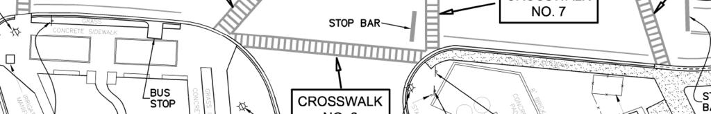
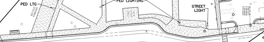
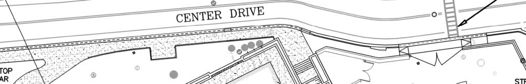
4 C. Physical Considerations 1. Hardscape Several existing hardscape issues present potentially dangerous situations for pedestrians along the corridor. a. The mountable curb along the eastern edge of Center Drive between the Mowry Road intersection and the corner of Bldg #206 presents a dangerous condition, as vehicles could easily travel off the roadway and into the path of the pedestrian. b. The curb cut ramp at the northeast corner of the Mowry Road intersection extends unnecessarily far to the north and should be rebuilt to direct traffic into the appropriate crosswalk space. c. Where Crosswalks #6 and #7 meet, the sidewalk landing area provides limited space, creating a claustrophobic feel in addition to being an inadequate refuge for the pedestrian. 2. Crosswalk Locations Many of the crosswalks could be better aligned to reflect real-world pedestrian patterns, and to improve the safety of the pedestrian. a. Crosswalk #5 sees the most high-volume pedestrian traffic of any crosswalk in the corridor. It also sees a high volume of violations. A realignment could improve flow patterns and safety at this location. b. The location of Crosswalk #10 creates potentially-hazardous situations. The location essentially within the loading area is not ideal, and limited visibility is available when cars are stopped for pedestrians in the crosswalk. Furthermore, it is not aligned with the main path of travel for Biomed/Communicore foot traffic. c. Crosswalk #12 sees a high volume of violations whereby traffic to and from the boardwalk continues along the boardwalk alignment, regardless of the actual crosswalk alignment in the street. 3. Other Physical Considerations Brown & Cullen Inc. a. Lighting was evaluated for appropriate locations as related to crosswalks and pedestrian safety. Ultimately, it was found that lighting was generally adequate except on the west side of Crosswalk #5. An additional street light is proposed here, which will greatly enhance visibility and safety. b. A lack of traffic calming devices adds to potential for pedestrian-vehicle impacts. c. Driver and pedestrian visibility along the corridor is limited due to a combination of limiting factors including several abrupt turns and kinks in the road, the tall brick wall along the east side, and the expansive intersection at Mowry Road. Potential exists to straighten out the UF Center Drive Pedestrian Crosswalk Study 4 of 10
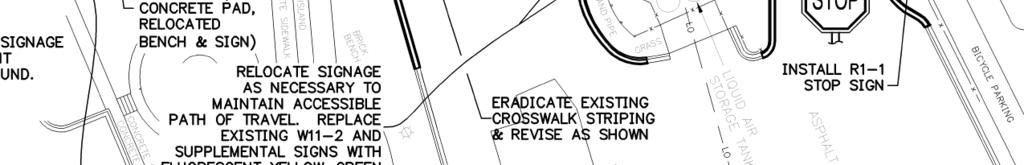
5 Center Drive alignment, thereby greatly improving visibility and functionality. IV. Short-Term Improvement Recommendations On June 18, 2010, BCI made a presentation to a variety of stakeholders whereby the data analysis and some early concepts for short-term and long-term remediation within the corridor were presented and discussed. The resulting consensus reached at this meeting was to devise a separate short-term plan of a few low-cost but high-impact remediations to key areas of the corridor. A second presentation was given to the University of Florida Transportation and Parking Committee on July 13, The Short Term, Intermediate, and Long-Term Improvement Plans were presented to the Committee, and a general approval of the proposed recommendations was provided. Through dialogue and a question and answer session with the committee, there was virtually no opposition to the suggested improvements. Sign-in sheets from these two meetings are included in Attachment D. The proposed Short Term Improvements can be seen in detail on the Short Term Improvements Plan (Attachment E), and are further described below. A. Crosswalk No. 1 No changes are proposed to this specific crosswalk. However, pedestrian traffic in the vicinity of this crosswalk had the greatest percentage of violations by far, in terms of straying out of the crosswalk (or in most instances, not using it at all). Due to the sidewalk patterns on the west side of Center Drive, the natural instinct is for the pedestrian to stay along the sidewalk alignments, which currently takes them directly into the street at a location outside of the crosswalk. By eliminating these angled sidewalk legs and re-routing the sidewalk to direct pedestrian traffic to Crosswalk No. 3, this reduces or eliminates the potential for conflicts. A dense hedge/shrubbery, fencing or other acceptable barrier should be provided between the new sidewalk and the existing curb to further discourage short cuts. A low-height seat wall may be desired to aid in pedestrian routing as well. Topography in this area will need to be evaluated to determine the potential need for a low retaining wall between the proposed new sidewalk and the parking garage. B. Crosswalk No. 3 A realignment of this crosswalk will be beneficial to maintain the flow and continuity from the Crosswalk No. 1 revisions listed above. Brown & Cullen Inc. UF Center Drive Pedestrian Crosswalk Study 5 of 10
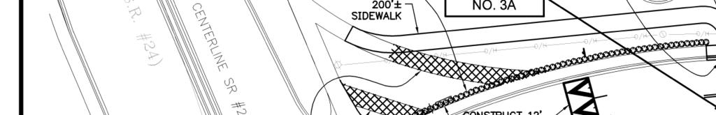
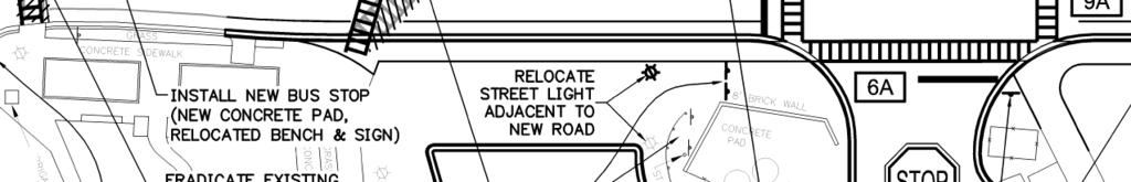
6 C. Crosswalk No. 5 As previously discussed, a lighting deficiency exists on the west side of Center Drive near Crosswalk No. 5. A new street light is proposed for installation at this location. D. Crosswalk No. 12 A reconfiguration of this crosswalk to align with the boardwalk on the west side of Center Drive is a quick and easy remedy to the consistent problem of pedestrian crosswalk violations. By aligning the crosswalk with the boardwalk, all pedestrian traffic will be directed in a straight-line travel path with the boardwalk. Observations revealed that virtually 100% of pedestrian traffic at this location is coming from or going to the boardwalk. Further revisions to the east side of this crosswalk will provide an improved curb cut ramp and ample pedestrian refuge zone where a cramped location currently exists. This will require pulling back the brick curb-wall to allot more space for usable pedestrian area and curb cut ramps. E. Signage All proposed pedestrian-crossing signage is to be fluorescent strong yellowgreen. This sign color greatly improves visibility (particularly at night) of the signage to the driver. Additional signage is also proposed in various locations, and existing signage is proposed for relocation to comply with the crosswalk improvements. 1. In-Street Pedestrian Crossing Signs In-Street Pedestrian Crossing Signage (MUTCD: R1-6A) is proposed at the north side of Crosswalk No. 12 and the south side of Crosswalk No. 3. These signs placed in the center of the street, at the entry points to the corridor, further capture the attention of the driver and are a low-cost, lowmaintenance way to call attention to the special needs of this high-use pedestrian zone. 2. Speed Hump Signage Each speed hump will be appropriately signed (MUTCD: W17-1) in each direction, with additional plaque signage indicating an appropriate 15 mph speed limit. 3. Speed Limit Signage Appropriate signage is located at the south end of the corridor to alert drivers entering the corridor of the 20 mph campus-wide speed limit. However, the suggested improvements will have an impact on the location Brown & Cullen Inc. UF Center Drive Pedestrian Crosswalk Study 6 of 10
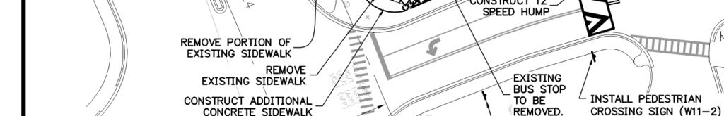
7 of the sign. As such, the speed limit sign would be located further south. No other speed limit signage is necessary or warranted within the corridor, with the exception of the 15 mph plaque signage to accompany the speed hump signs. 4. Pedestrian Crossing Signage To minimize the overabundance of flashing lights throughout the corridor, the Short Term Improvements Plan proposes a flashing beacon at each end of the corridor to accompany the standard Pedestrian Crossing (MUTCD: W11-2) sign, thus alerting drivers to heed caution without numbing them to the effects of the flashing light. All other beacons should be removed within the corridor to retain effectiveness. (Note: the red beacon on the stop sign at Mowry Road is proposed to remain.) A southbound approach to Crosswalk No. 3 will be additionally signed with a diagonal arrow. F. Additional Physical Improvements The site topography of the corridor places its north end at the bottom of a relatively steep hill, and around a corner. Additionally, the entry onto Center Drive from the south immediately puts drivers on a downhill slope. To aid in pedestrian safety, and to alert drivers entering this corridor, speed humps are proposed north of Crosswalk No. 1 and north of Crosswalk No. 12. These traffic calming devices will have a significant impact on the driver s attention and will likely greatly reduce any potential for vehicle-pedestrian conflicts by keeping the vehicle speeds reduced within the corridor. The existing bus stop location on the west side of Center Drive, at the south end of the corridor, is very close to Archer Road, and also impedes some of the proposed improvements. As such, a new bus stop location is proposed north of Crosswalk No. 3 to replace the existing bus stop. The existing bench and sign will be relocated. V. Intermediate Improvement Recommendations Additional improvements to the corridor are suggested in order to reduce the hazardous conditions of the existing environment, and to provide better overall safety to the pedestrians. These improvements may be more costly and more involved than the improvements suggested with the Short Term Improvements Plan. The Intermediate Improvements are shown on Attachment F, in conjunction with the Short Term Improvements described previously. The Intermediate Improvement Recommendations are described below: Brown & Cullen Inc. UF Center Drive Pedestrian Crosswalk Study 7 of 10
8 A. Crosswalk No. 5 Angling the west end of this crosswalk further to the south will help align foot traffic with the path of travel into the hospital, and will also bridge the gap between the two parking garage exits/entries. A realignment of the sidewalk from the parking garage stairwell helps direct pedestrians, and the sidewalk expansion will aid in traffic flow to and from the main parking garage entry/exit south of the stairs. B. Crosswalks No.6 & 7 Sidewalk expansion at the intersection of these two crosswalks provides a muchneeded refuge area for pedestrians, increasing the overall safety and comfort. Additionally, Crosswalk No. 7 is proposed to be shifted closer to the Mowry Road intersection, thus providing more fluid pedestrian movements in a more compact area. The connecting sidewalk from the northeast corner of the parking garage will be modified to better direct traffic into and out of the garage more in line with actual pedestrian traffic patterns. C. Crosswalk No. 8 A new sidewalk leg connecting the parking garage to the south end of this crosswalk will provide the pedestrian the instinctual path they are prone to take, and protect existing landscaping in this area by replacing the worn path with a concrete walk. D. Crosswalk No. 9 By reducing the width of the existing curb ramp, pedestrian traffic will be betterdirected toward the crosswalks, promoting a safer path of travel and reducing potential for roadway conflicts. E. Crosswalk No. 10 A significant improvement to this area would be to shift the crosswalk to the north of the Physical Therapy Education Center driveway. This would move the crosswalk out of the loading zone on the east side of Center Drive and improve the driveway entry there, would effectively reduce the width of the Physical Therapy driveway, and would involve shifting the bus stop further north. This would place the crosswalk within a more ideal alignment with the east-west sidewalk on the east side of the road, creating a more natural path of travel for the pedestrian and reducing the significant number of crosswalk violations in this vicinity. F. Crosswalk No. 11 Revisions to the sidewalk area at the south end of this crosswalk will accommodate a revised curb cut ramp (necessary with the shifting of the bus stop), and will eliminate the small patch of landscaping, thus providing a more pedestrian-friendly area to maneuver. Brown & Cullen Inc. UF Center Drive Pedestrian Crosswalk Study 8 of 10
9 G. Signage All pedestrian crossing signage within the corridor is proposed to be replaced with fluorescent yellow-green signage. Additional pedestrian crossing (MUTCD: W11-2) signage with supplemental plaques are proposed on the south side of Mowry Road as the approach to Center Drive to alert drivers of the high volume of pedestrian traffic within the corridor. The same signage is also proposed at the corner of Bldg #206 on the east side of Center Drive, to alert drivers of Crosswalk No. 10. A stop sign and stop bar are proposed at the parking garage exit, west of Crosswalk No. 4. H. Additional Physical Improvements The mountable curb along the eastern edge of Center Drive is proposed to be replaced with standard curb. The main reason for this improvement is to provide protection for the pedestrian traffic, as vehicles encroaching onto the sidewalk area create potential conflicts. The standard curb provides a physical barrier between pedestrian and vehicular traffic, whereas the existing mountable curb does not. It should be noted that this area is frequently utilized as an off-street drop-off zone for hospital patients and delivery vehicles. The high vehicular usage of this area provides some concern for the user groups if the mountable curb is replaced. The general concern is that vehicles will stop regardless, and will then be blocking vehicle and/or bicycle traffic lanes instead. As such, there may be a desire to keep the mountable curb as is, or possibly a less expansive section. In this circumstance, BCI recommends additional signage and/or sidewalk markings, additional sidewalk width to provide a safe and unencumbered path for pedestrians, and/or a designated paved pull-off area for vehicular traffic. Additional cost estimating should be evaluated depending upon the desired additional design elements discussed above. VI. Long-Term Improvement Recommendations Two conceptual long-term improvements plans are proposed and provided within Attachment G. The basic goal of the Long Term Improvements Plan is to straighten out the corridor, thus greatly improving visibility (and safety) of both the vehicle driver and the pedestrian. This plan also eliminates tight pedestrian spaces along the east side of the corridor. An additional benefit of this plan that was explored is to align the Shands loading dock entry with the Mowry Road intersection. The proposed concept greatly improves functionality and visibility by creating a 4-way stop and eliminating an awkward series of conflict points to the south of Mowry Road. Brown & Cullen Inc. UF Center Drive Pedestrian Crosswalk Study 9 of 10
10 The Alternate Long Term Improvements Plan adds northbound and southbound left turn lanes at the Mowry road intersection. The addition of these turn lanes will greatly enhance vehicle traffic flow by moving traffic appropriately, and providing more efficient access to the loading dock area for service vehicles Financial implications of this work are difficult to pinpoint, as a variety of unknowns associated with the Shands property, utilities, and other impacted facilities are significant and require major assessment beyond the scope of this study. VI. Cost Estimates for Improvements Construction cost estimate figures are based on the best available current, local construction costs for site construction. These costs are not representative of the sum total of all project costs associated with the improvements work. Typical additional costs not accounted for within the provided cost estimate would include (but not be limited to) General Conditions, Mobilization, Surveying, Staking, Layout, Testing, Erosion Control, Traffic Control, Geotechnical Testing, Tree Protection, additional demolition, additional earthwork, Landscaping, additional engineering/permitting, and more. General construction costs associated with the recommended improvements proposed within this study are provided in the Cost Estimating Spreadsheets, included as Attachment H. Brown & Cullen Inc. UF Center Drive Pedestrian Crosswalk Study 10 of 10
11 Attachment A Existing Conditions Plan Brown & Cullen Inc. UF Center Drive Pedestrian Crosswalk Study


12
13 Attachment B Collected Raw Data Brown & Cullen Inc. UF Center Drive Pedestrian Crosswalk Study
14 Data Collection Spreadsheet Date: 04/20/10 Project: UF Center Drive Pedestrian Study Name of Data Collector: Mary T. Green Crosswalk Location: (1) E/W Archer Road Begin End Eastbound Violation Westbound Violation E W Total Hourly 7:00 7: Totals 7:16 7: :31 7: :46 8: :01 8: :16 8: :31 8: :46 9: Begin End Eastbound Violation Westbound Violation E W Total Hourly 11:00 11: Totals 11:15 11: :30 11: :45 12: :00 12: :15 12: :30 12: :45 1: Begin End Eastbound Violation Westbound Violation E W Total Hourly 3:30 3: Totals 3:45 4: :00 4: :15 4: :30 4: :45 5: :00 5: :15 5:
15 Data Collection Spreadsheet Date: 04/21/10 Project: UF Center Drive Pedestrian Study Name of Data Collector: Mary T. Green Crosswalk Location: (1) E/W Archer Road Begin End Eastbound Violation Westbound Violation E W Total Hourly 7:00 7: Totals 7:16 7: :31 7: :46 8: :01 8: :16 8: :31 8: :46 9: Begin End Eastbound Violation Westbound Violation E W Total Hourly 11:00 11: Totals 11:15 11: :30 11: :45 12: :00 12: :15 12: :30 12: :45 1: Begin End Eastbound Violation Westbound Violation E W Total Hourly 3:30 3: Totals 3:45 4: :00 4: :15 4: :30 4: :45 5: :00 5: :15 5:
16 Data Collection Spreadsheet Name of Data Collector: Bennett Lloyd Project Name: Date: 4/20/2010 Time of Arrival: 6:40am Project Engineer: UF Center Drive Pedestrian Study Brown & Cullen Inc. (Dan Sostrom, P.E.) Crosswalk Location: (2) Across HSC Parking Lot (N/S) Crosswalk Location: (3) North Parking Garage (E/W) 7:00 7: Totals 7:00 7: Totals 7:16 7: :16 7: :31 7: :31 7: :46 8: :46 8: :01 8: :01 8: :16 8: :16 8: :31 8: :31 8: :46 9: :46 9: :00 11: Totals 11:00 11: Totals 11:15 11: :15 11: :30 11: :30 11: :45 12: :45 12: :00 12: :00 12: :15 12: :15 12: :30 12: :30 12: :45 1: :45 1: :30 3: Totals 3:30 3: Totals 3:45 4: :45 4: :00 4: :00 4: :15 4: :15 4: :30 4: :30 4: :45 5: :45 5: :00 5: :00 5: :15 5: :15 5: Crosswalk Location: (4) Across Parking Garage Driveway (N/S) Crosswalk Location: (5) South Parking Garage (E/W) 7:00 7: Totals 7:00 7: Totals 7:16 7: :16 7: :31 7: :31 7: :46 8: :46 8: :01 8: :01 8: :16 8: :16 8: :31 8: :31 8: :46 9: :46 9: :00 11: Totals 11:00 11: Totals 11:15 11: :15 11: :30 11: :30 11: :45 12: :45 12: :00 12: :00 12: :15 12: :15 12: :30 12: :30 12: :45 1: :45 1: :30 3: Totals 3:30 3: Totals 3:45 4: :45 4: :00 4: :00 4: :15 4: :15 4: :30 4: :30 4: :45 5: :45 5: :00 5: :00 5: :15 5: :15 5:
17 Data Collection Spreadsheet Name of Data Collector: Bennett Lloyd Project Name: Date: 4/21/2010 Time of Arrival: Project Engineer: UF Center Drive Pedestrian Study Brown & Cullen Inc. (Dan Sostrom, P.E.) Crosswalk Location: (2) Across HSC Parking Lot (N/S) Crosswalk Location: (3) North Parking Garage (E/W) 7:00 7: Totals 7:00 7: Totals 7:16 7: :16 7: :31 7: :31 7: :46 8: :46 8: :01 8: :01 8: :16 8: :16 8: :31 8: :31 8: :46 9: :46 9: :00 11: Totals 11:00 11: Totals 11:15 11: :15 11: :30 11: :30 11: :45 12: :45 12: :00 12: :00 12: :15 12: :15 12: :30 12: :30 12: :45 1: :45 1: :30 3: Totals 3:30 3: Totals 3:45 4: :45 4: :00 4: :00 4: :15 4: :15 4: :30 4: :30 4: :45 5: :45 5: :00 5: :00 5: :15 5: :15 5: Crosswalk Location: (4) Across Parking Garage Driveway (N/S) Crosswalk Location: (5) South Parking Garage (E/W) 7:00 7: Totals 7:00 7: Totals 7:16 7: :16 7: :31 7: :31 7: :46 8: :46 8: :01 8: :01 8: :16 8: :16 8: :31 8: :31 8: :46 9: :46 9: :00 11: Totals 11:00 11: Totals 11:15 11: :15 11: :30 11: :30 11: :45 12: :45 12: :00 12: :00 12: :15 12: :15 12: :30 12: :30 12: :45 1: :45 1: :30 3: Totals 3:30 3: Totals 3:45 4: :45 4: :00 4: :00 4: :15 4: :15 4: :30 4: :30 4: :45 5: :45 5: :00 5: :00 5: :15 5: :15 5:
18 Data Collection Spreadsheet Name of Data Collector: Susan Brown Project Name: Date: 4/20/2010 Time of Arrival: 6:40am Project Engineer: UF Center Drive Pedestrian Study Brown & Cullen Inc. (Dan Sostrom, P.E.) Crosswalk Location: (6) Crossing HSC Service Drive (N/S) Crosswalk Location: (7) North of Mowry (E/W) 7:00 7: Totals 7:00 7: Totals 7:16 7: :16 7: :31 7: :31 7: :46 8: :46 8: :01 8: :01 8: :16 8: :16 8: :31 8: :31 8: :46 9: :46 9: :00 11: Totals 11:00 11: Totals 11:15 11: :15 11: :30 11: :30 11: :45 12: :45 12: :00 12: :00 12: :15 12: :15 12: :30 12: :30 12: :45 1: :45 1: :30 3: Totals 3:30 3: Totals 3:45 4: :45 4: :00 4: :00 4: :15 4: :15 4: :30 4: :30 4: :45 5: :45 5: :00 5: :00 5: :15 5: :15 5: Crosswalk Location: (8) Crossing Mowry (N/S) Crosswalk Location: (9) South of Mowry (E/W) 7:00 7: Totals 7:00 7: Totals 7:16 7: :16 7: :31 7: :31 7: :46 8: :46 8: :01 8: :01 8: :16 8: :16 8: :31 8: :31 8: :46 9: :46 9: :00 11: Totals 11:00 11: Totals 11:15 11: :15 11: :30 11: :30 11: :45 12: :45 12: :00 12: :00 12: :15 12: :15 12: :30 12: :30 12: :45 1: :45 1: :30 3: Totals 3:30 3: Totals 3:45 4: :45 4: :00 4: :00 4: :15 4: :15 4: :30 4: :30 4: :45 5: :45 5: :00 5: :00 5: :15 5: :15 5:
19 Data Collection Spreadsheet Name of Data Collector: Susan Brown Project Name: Date: 4/21/2010 Time of Arrival: 6:30am Project Engineer: UF Center Drive Pedestrian Study Brown & Cullen Inc. (Dan Sostrom, P.E.) Crosswalk Location: (6) Crossing HSC Service Drive (N/S) Crosswalk Location: (7) North of Mowry (E/W) 7:00 7: Totals 7:00 7: Totals 7:16 7: :16 7: :31 7: :31 7: :46 8: :46 8: :01 8: :01 8: :16 8: :16 8: :31 8: :31 8: :46 9: :46 9: :00 11: Totals 11:00 11: Totals 11:15 11: :15 11: :30 11: :30 11: :45 12: :45 12: :00 12: :00 12: :15 12: :15 12: :30 12: :30 12: :45 1: :45 1: :30 3: Totals 3:30 3: Totals 3:45 4: :45 4: :00 4: :00 4: :15 4: :15 4: :30 4: :30 4: :45 5: :45 5: :00 5: :00 5: :15 5: :15 5: Crosswalk Location: (8) Crossing Mowry (N/S) Crosswalk Location: (9) South of Mowry (E/W) 7:00 7: Totals 7:00 7: Totals 7:16 7: :16 7: :31 7: :31 7: :46 8: :46 8: :01 8: :01 8: :16 8: :16 8: :31 8: :31 8: :46 9: :46 9: :00 11: Totals 11:00 11: Totals 11:15 11: :15 11: :30 11: :30 11: :45 12: :45 12: :00 12: :00 12: :15 12: :15 12: :30 12: :30 12: :45 1: :45 1: :30 3: Totals 3:30 3: Totals 3:45 4: :45 4: :00 4: :00 4: :15 4: :15 4: :30 4: :30 4: :45 5: :45 5: :00 5: :00 5: :15 5: :15 5:
20 Data Collection Spreadsheet Name of Data Collector: Mary Susan J. Weinstein Project Name: Date: 4/20/2010 Time of Arrival: 6:30am Project Engineer: UF Center Drive Pedestrian Study Brown & Cullen Inc. (Dan Sostrom, P.E.) Crosswalk Location: (10) Crossing to Biomed Engineering (E/W) Crosswalk Location: (11) Crossing HPNP Turnaround (N/S) Begin End Eastbound Violation Westbound Violation E W Total Hourly Begin End Northbound Violation Southbound Violation N S Total Hourly 7:00 7: Totals 7:00 7: Totals 7:16 7: :16 7: :31 7: :31 7: :46 8: :46 8: :01 8: :01 8: :16 8: :16 8: :31 8: :31 8: :46 9: :46 9: Begin End Eastbound Violation Westbound Violation E W Total Hourly Begin End Northbound Violation Southbound Violation N S Total Hourly 11:00 11: Totals 11:00 11: Totals 11:15 11: :15 11: :30 11: :30 11: :45 12: :45 12: :00 12: :00 12: :15 12: :15 12: :30 12: :30 12: :45 1: :45 1: Begin End Eastbound Violation Westbound Violation E W Total Hourly Begin End Northbound Violation Southbound Violation N S Total Hourly 3:30 3: Totals 3:30 3: Totals 3:45 4: :45 4: :00 4: :00 4: :15 4: :15 4: :30 4: :30 4: :45 5: :45 5: :00 5: :00 5: :15 5: :15 5: Crosswalk Location: (12) Creek (E/W) Crosswalk Location: (13) Non-Crosswalk Crossings (Violations) Begin End Eastbound Violation Westbound Violation E W Total Hourly Begin End Eastbound Violation Westbound Violation E W Total Hourly 7:00 7: Totals 7:00 7: Totals 7:16 7: :16 7: :31 7: :31 7: :46 8: :46 8: :01 8: :01 8: :16 8: :16 8: :31 8: :31 8: :46 9: :46 9: Begin End Eastbound Violation Westbound Violation E W Total Hourly Begin End Eastbound Violation Westbound Violation E W Total Hourly 11:00 11: Totals 11:00 11: Totals 11:15 11: :15 11: :30 11: :30 11: :45 12: :45 12: :00 12: :00 12: :15 12: :15 12: :30 12: :30 12: :45 1: :45 1: Begin End Eastbound Violation Westbound Violation E W Total Hourly Begin End Eastbound Violation Westbound Violation E W Total Hourly 3:30 3: Totals 3:30 3: Totals 3:45 4: :45 4: :00 4: :00 4: :15 4: :15 4: :30 4: :30 4: :45 5: :45 5: :00 5: :00 5: :15 5: :15 5:
21 Data Collection Spreadsheet Name of Data Collector: Mary Susan J. Weinstein Project Name: Date: 4/21/2010 Time of Arrival: 6:45am Project Engineer: UF Center Drive Pedestrian Study Brown & Cullen Inc. (Dan Sostrom, P.E.) Crosswalk Location: (10) Crossing to Biomed Engineering (E/W) Crosswalk Location: (11) Crossing HPNP Turnaround (N/S) Begin End Eastbound Violation Westbound Violation E W Total Hourly Begin End Northbound Violation Southbound Violation N S Total Hourly 7:00 7: Totals 7:00 7: Totals 7:16 7: :16 7: :31 7: :31 7: :46 8: :46 8: :01 8: :01 8: :16 8: :16 8: :31 8: :31 8: :46 9: :46 9: Begin End Eastbound Violation Westbound Violation E W Total Hourly Begin End Northbound Violation Southbound Violation N S Total Hourly 11:00 11: Totals 11:00 11: Totals 11:15 11: :15 11: :30 11: :30 11: :45 12: :45 12: :00 12: :00 12: :15 12: :15 12: :30 12: :30 12: :45 1: :45 1: Begin End Eastbound Violation Westbound Violation E W Total Hourly Begin End Northbound Violation Southbound Violation N S Total Hourly 3:30 3: Totals 3:30 3: Totals 3:45 4: :45 4: :00 4: :00 4: :15 4: :15 4: :30 4: :30 4: :45 5: :45 5: :00 5: :00 5: :15 5: :15 5: Crosswalk Location: (12) Creek (E/W) Crosswalk Location: (13) Non-Crosswalk Crossings (Violations) Begin End Eastbound Violation Westbound Violation E W Total Hourly Begin End Eastbound Violation Westbound Violation E W Total Hourly 7:00 7: Totals 7:00 7: Totals 7:16 7: :16 7: :31 7: :31 7: :46 8: :46 8: :01 8: :01 8: :16 8: :16 8: :31 8: :31 8: :46 9: :46 9: Begin End Eastbound Violation Westbound Violation E W Total Hourly Begin End Eastbound Violation Westbound Violation E W Total Hourly 11:00 11: Totals 11:00 11: Totals 11:15 11: :15 11: :30 11: :30 11: :45 12: :45 12: :00 12: :00 12: :15 12: :15 12: :30 12: :30 12: :45 1: :45 1: Begin End Eastbound Violation Westbound Violation E W Total Hourly Begin End Eastbound Violation Westbound Violation E W Total Hourly 3:30 3: Totals 3:30 3: Totals 3:45 4: :45 4: :00 4: :00 4: :15 4: :15 4: :30 4: :30 4: :45 5: :45 5: :00 5: :00 5: :15 5: :15 5:
22 Attachment C Traffic Study Data Brown & Cullen Inc. UF Center Drive Pedestrian Crosswalk Study
23
24 Attachment D Sign-In Sheets Stakeholder Meeting (June 18, 2010) and Parking & Transportation Committee Meeting (July 13, 2010) Brown & Cullen Inc. UF Center Drive Pedestrian Crosswalk Study
25
26
27 Attachment E Short-Term Improvements Plan Brown & Cullen Inc. UF Center Drive Pedestrian Crosswalk Study


28
29 Attachment F Intermediate Improvements Plan Brown & Cullen Inc. UF Center Drive Pedestrian Crosswalk Study


30
31 Attachment G Long Term Improvements Plan & Long Term Improvements Plan Alternate Brown & Cullen Inc. UF Center Drive Pedestrian Crosswalk Study


32


33
34 Attachment H Cost Estimates Brown & Cullen Inc. UF Center Drive Pedestrian Crosswalk Study
35 UF Center Drive Pedestrian Study Estimated Construction Quantities Short Term Improvements Item Description Unit Quantity Unit Price Item Cost Crosswalks No Remove Existing Sidewalk SF 960 $1.00 $ Construct New Sidewalk SF 1,800 $3.00 $5, Revised Curb Cut Ramp EA 1 $1, $1, Construct 12' x 32' Speed Hump EA 1 $ $ Eradicate Existing Crosswalk Striping & Stripe New Crosswalk EA 1 $1, $1, Install Pedestrian Crossing Sign EA 2 $ $ Install In-Street Ped Xing Sign EA 1 $ $ Ped Sign Warning Beacon EA 1 $ $ Install Speed Hump Sign EA 2 $ $ Dense Shrubbery LS 1 $2, $2, Remove Existing Sign EA 1 $ $ Relocate Existing Sign EA 1 $ $ New Bus Stop Concrete Pad SF 60 $3.00 $ Demolish Existing Bus Stop Concrete LS 1 $ $ Relocate Bus Stop Bench and Signage LS 1 $ $ Subtotal $14, Crosswalk No. 5 1 Install Street Light Pole and Fixture EA 1 $3, $3, Subtotal $3, Crosswalk No Install Speed Hump Sign EA 2 $ $ Construct 12' x 32' Speed Hump EA 1 $ $ Install In-Street Ped Xing Sign EA 1 $ $ Relocate Existing Sign EA 1 $ $ Ped Sign Warning Beacon EA 1 $ $ Eradicate Existing Crosswalk Striping & Stripe New Crosswalk EA 1 $1, $1, Revised Curb Cut Ramp EA 1 $1, $1, Remove Curb Cut Ramp, Replace with new Sidewalk and C&G EA 1 $1, $1, Install New Curb Cut Ramp EA 1 $1, $1, Construct New Sidewalk / Concrete SF 200 $3.00 $ Revised Brick Curb Wall LS 1 $1, $1, Subtotal $8, Additional services 1 Engineering Design Services LS 1 $5, $5, Construction Contingency (10%) LS 1 $2, $2, Total: $33, * Note: The quantities shown hereon are engineering estimates only. Unit prices are based on best available historical data. Actual construction costs may vary. Additional costs not accounted for here may include (but not be limited to) General Conditions, Mobilization, Surveying, Staking, Layout, Testing, Erosion Control, Traffic Control, Geotechnical Testing, Tree Protection, additional demolition, additional earthwork, Landscaping, additional engineering/permitting, and more.
36 UF Center Drive Pedestrian Study Estimated Construction Quantities Intermediate Improvements (Including Short Term Improvements) Item Description Unit Quantity Unit Price Item Cost Crosswalks No (See Short Term Improvements Estimate for detail) LS 1 $14, $14, Crosswalk No. 4 1 Install Stop Sign EA 1 $ $ Install Stop Bar EA 1 $ $ Subtotal $ Crosswalk No. 5 1 Eradicate Existing Crosswalk Striping & Stripe New Crosswalk EA 1 $1, $1, Remove existing sidewalk SF 140 $1.00 $ Remove Curb Cut Ramp, Replace with new Sidewalk and C&G EA 1 $1, $1, Construct New Sidewalk / Concrete EA 270 $3.00 $ Construct New Curb Cut Ramp EA 1 $1, $1, (Short Term Improvements) LS 1 $3, $3, Subtotal $7, Crosswalk No Reconstruct Curb Cut Ramp EA 2 $1, $2, Additional Concrete Sidewalk SF 635 $3.00 $1, Replace existing signage with Fluorescent Signage EA 2 $ $ Relocate Existing Sign EA 1 $ $ Eradicate Existing Crosswalk Striping & Stripe New Crosswalk EA 1 $1, $1, Remove existing sidewalk SF 125 $1.00 $ Subtotal $5, Crosswalk No. 8 1 Additional Concrete Sidewalk SF 160 $3.00 $ Install Pedestrian Crossing Sign EA 1 $ $ Subtotal $ Crosswalk No Remove Mountable Curb LF 215 $6.00 $1, Install Type 'F' C&G LF 215 $15.00 $3, Reconstruct Concrete Sidewalk SF 2,200 $3.00 $6, Install Pedestrian Crossing Sign EA 1 $ $ Subtotal $11, Crosswalk No Eradicate Existing Crosswalk Striping & Stripe New Crosswalk EA 1 $1, $1, Remove Curb Cut Ramp, Replace with new Sidewalk and C&G EA 3 $1, $3, Revise Existing Driveway EA 1 $2, $2, Install Pedestrian Crossing Sign EA 1 $ $ Construct New Curb Cut Ramp EA 1 $1, $1, Revised Bus Stop LS 1 $10, $10, Additional Concrete Sidewalk SF 50 $3.00 $ Subtotal $17, Crosswalk No (See Short Term Improvements Estimate for detail) LS 1 $8, $8, Additional services 1 Engineering Design Services LS 1 $10, $10, Construction Contingency (10%) LS 1 $6, $6, Total: $82, * Note: The quantities shown hereon are engineering estimates only. Unit prices are based on best available historical data. Actual construction costs may vary. Additional costs not accounted for here may include (but not be limited to) General Conditions, Mobilization, Surveying, Staking, Layout, Testing, Erosion Control, Traffic Control, Geotechnical Testing, Tree Protection, additional demolition, additional earthwork, Landscaping, additional engineering/permitting, and more.
37 UF Center Drive Pedestrian Study Estimated Construction Quantities Long Term Improvements (Including Short Term and Intermediate Improvements) Item Description Unit Quantity Unit Price Item Cost General Conditions 1 Mobilization & General Conditions LS 1 $50, $50, Construction Signage & Traffic Control LS 1 $35, $35, Construction Surveying & Testing LS 1 $30, $30, Tree Protection LS 1 $3, $3, Erosion control LS 1 $10, $10, Projected Long-Term Improvements - Corridor Straightening 1 Demolish Existing Pavement SY 3,100 $2.00 $6, Demolish Existing Curb LF 1,500 $3.00 $4, Remove existing sidewalk SF 10,000 $1.00 $10, Revised Road Alignment - Paving SY 3,680 $30.00 $110, Additional Pavement Markings & Signage LS 1 $5, $5, Earthwork LS 1 $60, $60, Stormwater Revisions LS 1 $100, $100, Other Utility Revisions / Adjustments LS 1 $300, $300, Landscaping LS 1 $30, $30, Concurrent Intermediate Improvements 1 (See Intermediate Improvements Estimate for detail) LS 1 $82, $82, Additional services 1 Engineering Design Services LS 1 $85, $85, Construction Contingency (10%) LS 1 $81, $81, Total: $875, * Note: The quantities shown hereon are engineering estimates only. Unit prices are based on best available historical data. Actual construction costs may vary. Additional costs not accounted for here may include (but not be limited to) General Conditions, Mobilization, Surveying, Staking, Layout, Testing, Erosion Control, Traffic Control, Geotechnical Testing, Tree Protection, additional demolition, additional earthwork, Landscaping, additional engineering/permitting, and more.
Windy Ridge Elementary School
 Windy Ridge Elementary School SCHOOL ROUTE PLAN For WINDY RIDGE ELEMENTARY SCHOOL LOCATION 54 ORANGE COUNTY Prepared for: ORANGE COUNTY SCHOOL ASSESSMENT PROGRAM ORANGE COUNTY PUBLIC WORKS Traffic Engineering
Hidden Oaks Elementary School
 Hidden Oaks Elementary School SCHOOL ROUTE PLAN For HIDDEN OAKS ELEMENTARY SCHOOL LOCATION 13 ORANGE COUNTY Prepared for: ORANGE COUNTY SCHOOL ASSESSMENT PROGRAM ORANGE COUNTY PUBLIC WORKS Traffic Engineering
Orange Center Elementary School
 Drag and drop pic and stretch/crop to the limits of the blue rectangle (delete this text box) Orange Center Elementary School Drag and drop pic and stretch/crop to the limits of the blue rectangle (delete
IMPLEMENTATION WORKBOOK
 Lawrence Township Bicycle and Pedestrian Planning Assistance Study IMPLEMENTATION WORKBOOK Final Action Plan - Part 2 April 2009 Prepared For: The Township of Lawrence and the New Jersey Department of
Memorandum. Sunday, July 13, Saturday, July 19, 2014
 Memorandum To: David Lowin, Brooklyn Bridge Park Corporation From: Daniel Schack, AICP, PTP Date: Re: Brooklyn Bridge Park Pier 5/6 Loop Road Traffic Study Project No: 14-01-2407 At the request of Brooklyn
Meadow Woods Elementary School
 Drag and drop pic and stretch/crop to the limits of the blue rectangle (delete this text box) Meadow Woods Elementary School Drag and drop pic and stretch/crop to the limits of the blue rectangle (delete
WEST AVENUE AND NEW ROAD TRAFFIC STUDY PART III WEST AVENUE CLOSURE ALTERNATIVES ANALYSIS
 WEST AVENUE AND NEW ROAD TRAFFIC STUDY PART III WEST AVENUE CLOSURE ALTERNATIVES ANALYSIS CITY OF LINWOOD ATLANTIC COUNTY, NEW JERSEY March 30, 2006 PREPARED FOR: City of Linwood 400 Poplar Avenue Linwood,
Drag and drop pic and stretch/crop to the limits of the blue rectangle (delete this text box) Maxey Elementary School
 Maxey Elementary School") Drag and drop pic and stretch/crop to the limits of the blue rectangle (delete this text box) Maxey Elementary School SCHOOL ROUTE PLAN For MAXEY ELEMENTARY SCHOOL LOCATION 33 ORANGE COUNTY Prepared for:
Drag and drop pic and stretch/crop to the limits of the blue rectangle (delete this text box) Maxey Elementary School SCHOOL ROUTE PLAN For MAXEY ELEMENTARY SCHOOL LOCATION 33 ORANGE COUNTY Prepared for:
Traffic Circulation & Pedestrian Safety Study
 Lyons Township High School North Campus La Grange, Illinois Parking Lot Vaughan Building N Main Building Prepared for: Prepared by: July 23, 2015 Contents List of Figures, iii 1. Introduction...1 2. Existing
AGENDA ITEM 6 D THOMASVILLE ROAD (HERMITAGE BOULEVARD TO LIVE OAK PLANTATION ROAD) ROADWAY SAFETY AUDIT
 ROADWAY SAFETY AUDIT") May 15, 2018 AGENDA ITEM 6 D THOMASVILLE ROAD (HERMITAGE BOULEVARD TO LIVE OAK PLANTATION ROAD) ROADWAY SAFETY AUDIT TYPE OF ITEM: Discussion STATEMENT OF ISSUE The Florida Department of Transportation
May 15, 2018 AGENDA ITEM 6 D THOMASVILLE ROAD (HERMITAGE BOULEVARD TO LIVE OAK PLANTATION ROAD) ROADWAY SAFETY AUDIT TYPE OF ITEM: Discussion STATEMENT OF ISSUE The Florida Department of Transportation
Lake Whitney Elementary School
 Lake Whitney Elementary School SCHOOL ROUTE PLAN For LAKE WHITNEY ELEMENTARY SCHOOL LOCATION 18 ORANGE COUNTY Prepared for: ORANGE COUNTY SCHOOL ASSESSMENT PROGRAM ORANGE COUNTY PUBLIC WORKS Traffic Engineering
Broad Street Bicycle Boulevard Design Guidelines
 Broad Street Bicycle Boulevard Design Guidelines Building from the strategies introduced in the 2013 Bicycle Transportation Plan and community input received thus far, City Transportation Staff have identified
MEMORANDUM. Charlotte Fleetwood, Transportation Planner
 MEMORANDUM Date: Updated August 22, 2017 To: Organization: Charlotte Fleetwood, Transportation Planner Boston Transportation Department From: Jason DeGray, P.E., PTOE, Regional Director of Engineering
SCHOOL ROUTE PLAN. For HUNTER S CREEK ELEMENTARY SCHOOL LOCATION 14 ORANGE COUNTY. Prepared for:
 SCHOOL ROUTE PLAN For HUNTER S CREEK ELEMENTARY SCHOOL LOCATION 14 ORANGE COUNTY Prepared for: ORANGE COUNTY SCHOOL ASSESSMENT PROGRAM ORANGE COUNTY PUBLIC WORKS Traffic Engineering Division 42 South John
Transportation Planning Division
 Transportation Planning Division Presentation Outline Study Tasks Recap of Previous Meetings Data Collected Focus Areas within Study Limits Design Principles Tool Box Recommended Concepts Schedule Moving
CITY OF OTTAWA ROADWAY MODIFICATION APPROVAL UNDER DELEGATED AUTHORITY
 RMA-2015-ATM-038 CITY OF OTTAWA ROADWAY MODIFICATION APPROVAL UNDER DELEGATED AUTHORITY DATE: April 22, 2015 SUBJECT Approval of Roadway Modifications Recommended through an Area Traffic Management Study
City of Albert Lea Policy and Procedure Manual 4.10 ALBERT LEA CROSSWALK POLICY
 4.10 ALBERT LEA CROSSWALK POLICY PURPOSE: Pedestrian crosswalks are an integral part of our transportation infrastructure. To be effective and promote safety, marked crosswalks must be installed after
Off-road Trails. Guidance
 Off-road Trails Off-road trails are shared use paths located on an independent alignment that provide two-way travel for people walking, bicycling, and other non-motorized users. Trails specifically along
City of Margate, Florida. Neighborhood Traffic Management Manual
 City of Margate, Florida Neighborhood Traffic Management Manual Table of Contents Page No. I. INTRODUCTION... 1 II. TRAFFIC CALMING REQUEST AND PROCESSING PROCEDURES... 2 1. COMPLETE AND SUBMIT PROJECT
Appendix T CCMP TRAIL TRAFFIC & TRANSPORTATION DESIGN STANDARD
 Appendix T CCMP 3.3.4 TRAIL TRAFFIC & TRANSPORTATION DESIGN STANDARD 3.3.4 Trail Traffic and Transportation Design Multi-use trails have certain design standards, which vary depending on the agency that
Durrance Elementary School
 Durrance Elementary School SCHOOL ROUTE PLAN For DURRANCE ELEMENTARY SCHOOL LOCATION 9 ORANGE COUNTY Prepared for: ORANGE COUNTY SCHOOL ASSESSMENT PROGRAM ORANGE COUNTY PUBLIC WORKS Traffic Engineering
Tonight is for you. Learn everything you can. Share all your ideas.
 Strathcona Neighbourhood Renewal Draft Concept Design Tonight is for you. Learn everything you can. Share all your ideas. What is Neighbourhood Renewal? Creating a design with you for your neighbourhood.
4 GENERIC COST ESTIMATING TOOL
 4 GENERIC COST ESTIMATING TOOL Table 4-1 presents a generic cost estimating tools that can serve as a conceptual planning tool for local jurisdictions to estimate the costs of pedestrian improvements.
DEPARTMENT OF ENVIRONMENTAL SERVICES. North Harrison Street (Lee Highway to Little Falls Road) Comparative Analysis. Prepared for:
 Comparative Analysis. Prepared for:") DEPARTMENT OF ENVIRONMENTAL SERVICES North Harrison Street (Lee Highway to Little Falls Road) Comparative Analysis Prepared for: Arlington County Department of Environmental Services 2100 Clarendon Boulevard,
DEPARTMENT OF ENVIRONMENTAL SERVICES North Harrison Street (Lee Highway to Little Falls Road) Comparative Analysis Prepared for: Arlington County Department of Environmental Services 2100 Clarendon Boulevard,
Chapter 3.9 Timbercrest Elementary School. Volusia County MPO. November 2008
 Chapter 3.9 Timbercrest Elementary School Deltona, FL Volusia County MPO November 2008 Volusia County MPO School Bicycle and Pedestrian Review Study, Phase 3B School Summary Timbercrest Elementary School
July 5, Arthur R. Ware, Jr. Elementary School 2017 Safe Routes to School Walkabout Report
 July 5, 2017 Arthur R. Ware, Jr. Elementary School 2017 Safe Routes to School Walkabout Report 1 Walkabout Report Introduction On April 28, 2017, City, School, and SAWMPO staff met to conduct a Safe Routes
Summary: Mercer County Princeton Avenue & Spruce Street Study January 2009
 Summary: Several recent studies have assessed potential development and redevelopment opportunities in the Mercer Crossing area of Trenton, Ewing, and Lawrence. This Princeton Avenue and Spruce Street
Typical Cross Section: DOWNTOWN (Observer Highway - 8th Street)
") Typical Cross Section: DOWNTOWN (Observer Highway - 8th Street) DRAFT SEPTEMBER 23, 14 1 Washington Street Typical Block Downtown Typical Block: DOWNTOWN (Observer Highway - 8th Street) New crosswalks
Typical Cross Section: DOWNTOWN (Observer Highway - 8th Street) DRAFT SEPTEMBER 23, 14 1 Washington Street Typical Block Downtown Typical Block: DOWNTOWN (Observer Highway - 8th Street) New crosswalks
FOCUS AREA 1 - Alberta Avenue Pocket Park 3 (121 Ave and 92 St)
") FOCUS AREA 1 - Alberta Avenue Pocket Park 3 (121 Ave and 92 St) New benches Plant evergreen trees Widen existing sidewalk from 1.5m to 1.8m Marked crosswalk 1.8m wide sidewalk Add pedestrian oriented lights
FOCUS AREA 1 - Alberta Avenue Pocket Park 3 (121 Ave and 92 St) New benches Plant evergreen trees Widen existing sidewalk from 1.5m to 1.8m Marked crosswalk 1.8m wide sidewalk Add pedestrian oriented lights
FLORIDA DEPARTMENT OF TRANSPORTATION DISTRICT 7 DISTRICT WIDE BICYCLE/PEDESTRIAN ACCESS TO TRANSIT SAFETY ASSESSMENT AND IMPROVEMENT PLAN
 FLORIDA DEPARTMENT OF TRANSPORTATION DISTRICT 7 DISTRICT WIDE BICYCLE/PEDESTRIAN ACCESS TO TRANSIT SAFETY ASSESSMENT AND IMPROVEMENT PLAN TRANSIT SAFETY ASSESSMENT SR 55/US 19 AT 80 TH AVE N DRAFT JUNE
MEMORANDUM. Date: 9/13/2016. Citywide Crosswalk Policy
 MEMORANDUM Date: 9/13/2016 Re: Citywide Crosswalk Policy Foreword Through the s Circulation Element and Complete Streets Policy, it is the City s goal to promote walking trips and provide safe facilities
Chapter 2: Standards for Access, Non-Motorized, and Transit
 Standards for Access, Non-Motorized, and Transit Chapter 2: Standards for Access, Non-Motorized, and Transit The Washtenaw County Access Management Plan was developed based on the analysis of existing
APPENDIX A: Complete Streets Checklist DRAFT NOVEMBER 2016
 APPENDIX A: Complete Streets Checklist DRAFT NOVEMBER 2016 Complete Streets Checklist MetroPlan Orlando s Complete Streets Checklist is an internal planning tool for staff to further implementation of
Shockoe Bottom Preliminary Traffic and Parking Analysis
 Shockoe Bottom Preliminary Traffic and Parking Analysis Richmond, Virginia August 14, 2013 Prepared For City of Richmond Department of Public Works Prepared By 1001 Boulders Pkwy Suite 300, Richmond, VA
Bases, Ballasts, and Paving
 Sections Included In This Standard: 1.1 Paving and Surfacing 1.2 Protection of the Work 1.3 Repair of Pavement 1.4 Pavement Marking 1.1 PAVING AND SURFACING A. DESIGN REQUIREMENTS 1. Applicable Design
Final Sidewalk Feasibility Study
 Garfield Drive From Anastasia Drive to Elizabeth Place City of South Daytona July 23, 2009 Final Sidewalk Feasibility Study Prepared for: Prepared by: Final Sidewalk Feasibility Study Garfield Drive 2
Military Road Safety Improvements
 Military Road Safety Improvements 26 th Road North to 31 st Street North SUMMARY OF DATA REVIEW AND PRELIMINARY RECOMMENDATIONS Prepared for: Department of Environmental Services Traffic Engineering and
Improving Cyclist Safety at the Dundas Street West and Sterling Road Intersection
 STAFF REPORT ACTION REQUIRED Improving Cyclist Safety at the Dundas Street West and Sterling Road Intersection Date: August 17, 2012 To: From: Wards: Reference Number: Public Works and Infrastructure Committee
Readington Road (C.R. 637) Construction
 Construction") Public Information Meeting Thursday, August 2, 2012 Readington Road (C.R. 637) Construction from Dreahook Road to Harlan School Road Branchburg Township, Somerset County Readington Township, Hunterdon
Public Information Meeting Thursday, August 2, 2012 Readington Road (C.R. 637) Construction from Dreahook Road to Harlan School Road Branchburg Township, Somerset County Readington Township, Hunterdon
AGENDA REPORT. Issue: Discussion of potential improvements on Barnwell Road at Niblick Drive
 AGENDA REPORT To: From: By: Honorable Mayor and City Council Members Warren Hutmacher, City Manager Tom Black, Public Works Director Date: March 23, 2016 Agenda: March 28, 2016 WORK SESSION AGENDA: Barnwell
Appendix C. TRAFFIC CALMING PROGRAM TOOLBOX
 Appendix C. TRAFFIC CALMING PROGRAM TOOLBOX PHASE I...2 Do Not Enter Sign...3 One-Way Sign...4 Turn Prohibition...5 Pavement Markings...6 Speed Monitoring Trailer...7 Neighborhood Speed Watch...8 Police
Lincoln Highway Streetscape Plan Concept Plan
 Lincoln Highway Streetscape Plan Concept Plan November 14, 2014 Introduction This report provides a summary of conceptual transportation, land use, and design recommendations in the Lincoln Highway Streetscape
Comments EXECUTIVE SUMMARY
 Comments 1. Under any Alternatives, MCDOT should provide better at-grade pedestrian crossing of Georgia Avenue and Forest Glen Road, including improved crosswalks with wider medians and adequate signal
FINAL SCOPING REPORT. Bennington Streetscape Improvement Project BENNINGTON STP SDWK (12) August Bennington County Regional Commission
 August Bennington County Regional Commission") FINAL SCOPING REPORT Bennington Streetscape Improvement Project BENNINGTON STP SDWK (12) August 214 Bennington County Regional Commission Table of Contents Purpose & Need 3 Project Area Photos 5 Conceptual
FINAL SCOPING REPORT Bennington Streetscape Improvement Project BENNINGTON STP SDWK (12) August 214 Bennington County Regional Commission Table of Contents Purpose & Need 3 Project Area Photos 5 Conceptual
City of Scotts Valley CITY COUNCIL STAFF REPORT
 DATE: April 19, 2017 City of Scotts Valley CITY COUNCIL STAFF REPORT AGENDA ITEM 2 DATE: 4-19-2017 TO: FROM: APPROVED: SUBJECT: Honorable Mayor and City Council Scott Hamby, Public Works Director Jenny
Ottawa Beach Road Study
 Ottawa Beach Road Study Prepared For: Park Township September 30, 2014 Project No. G140303 OTTAWA BEACH ROAD STUDY PREPARED FOR: PARK TOWNSHIP SEPTEMBER 30, 2014 PROJECT NO. G140303 TABLE OF CONTENTS 1.0
Caltrans Sloat Boulevard Pedestrian Safety Project Response to Community Questions, Comments & Concerns
 Caltrans Sloat Boulevard Pedestrian Safety Project Response to Community Questions, Comments & Concerns Revised: May 10, 2016 The California Department of Transportation (Caltrans) is planning various
DRAFT. A fifth objective, other considerations, has been added to capture considerations not captured by the four primary objectives.
 TECHNICAL MEMORANDUM Albany - Washington Avenue Traffic Calming Evaluation Matrix of Conceptual Alternatives Date: May 17, 2017 Project #: 17356 To: Aleida Andrino-Chavez From: Laurence Lewis, Sara Muse,
Mission Bay Loop (MBL) Public Meeting
 Public Meeting") Mission Bay Loop (MBL) Public Meeting La Scuola Internazionale di San Francisco, November 18, 2014 Frequently Asked Questions 1. When would construction have to start before the SFMTA loses TIGER funds?
Mission Bay Loop (MBL) Public Meeting La Scuola Internazionale di San Francisco, November 18, 2014 Frequently Asked Questions 1. When would construction have to start before the SFMTA loses TIGER funds?
1. Executive Summary The purpose of this document is to provide support and justification for a pedestrian hybrid beacon or High-Intensity Activated C
 N. Grand Avenue at Ritchie Pedestrian Crossing - Phase 1 Technical Memorandum Prepared by DN Traffic Consultants For the City of Pullman September 2015 1. Executive Summary The purpose of this document
Date: April 4, Project #: Re: A Street/Binford Street Traffic/Intersection Assessment
 To: Peter Cavanaugh General Electric From: David Bohn, PE Ryan White, PE Date: April 4, 217 Project #: 13421. Re: / Traffic/Intersection Assessment Consistent with the Cooperation Agreement between the
Joshua Jester, E.I., Florida Department of Transportation, District One
 MEMORANDUM To: From: Joshua Jester, E.I., Florida Department of Transportation, District One Michael Garau, P.E., Kimley-Horn and Associates, Inc. Date: October 5, 2018 Subject: at Gulfstream Avenue Intersection
Appendix A: Crosswalk Policy
 Appendix A: Crosswalk Policy Appendix A: Crosswalk Policy Introduction This citywide Crosswalk Policy is aimed at improving pedestrian safety and enhancing pedestrian mobility by providing a framework
APPENDIX E GRADE CROSSING LOCATIONS
 APPENDIX E GRADE CROSSING LOCATIONS 1 2 3 Citrus Avenue Riverside County and City Palmyrita Avenue Columbia Avenue MP 0.57 002X-0.6 027301Y MP 1.00 002X-1.0 027302F MP 1.24 002X-1.3 027303M 1. Existing
City of Memphis On-Street Parking Modification Guidelines
 City of Memphis Effective Date: December 1, 2013 Bicycle/Pedestrian Program 125 N. Main Street Memphis, TN 38103 (901) 576-6710 www.bikepedmemphis.com City of Memphis Executive Summary It is current practice
133 rd Street and 132 nd /Hemlock Street 132 nd Street and Foster Street MINI ROUNDABOUTS. Overland Park, Kansas
 133 rd Street and 132 nd /Hemlock Street 132 nd Street and Foster Street MINI ROUNDABOUTS Overland Park, Kansas September 1, 2017 TABLE OF CONTENTS 1. INTRODUCTION... 1 2. LITERATURE REVIEW... 1 3. CONCEPT
ADA PRESENTATION (CURB RAMPS)
") ADA PRESENTATION (CURB RAMPS) ACECNJ/NJDOT/FHWA DESIGN SUMMIT Warren Howard New Jersey Department of Transportation May 21, 2013 ADA Curb Ramps NJDOT wants curb ramps to be designed & constructed properly
ADA PRESENTATION (CURB RAMPS) ACECNJ/NJDOT/FHWA DESIGN SUMMIT Warren Howard New Jersey Department of Transportation May 21, 2013 ADA Curb Ramps NJDOT wants curb ramps to be designed & constructed properly
A. Arlington County Master Transportation Plan Pedestrian Element B. Arlington County Horizontal Standards H-3.1 Driveway Entrances
 GENERAL 1. Description This standard identifies minimum requirements that shall be met for all accessible ramps in the design and construction of elements for Arlington County Horizontal Design Standards.
6.4 RECOMMENDED IMPROVEMENTS
 6.4 RECOMMENDED IMPROVEMENTS 6.4.1 Williston Road Recommendations While all alternatives would be an improvement over existing conditions, Alternative 3B is recommended over the others because it provides
Clay Street Bridge Replacement Project
 Clay Street Bridge Replacement Project Frequently Asked Questions (FAQs) The project is located in downtown Placerville on Clay Street between US Highway 50 and Main Street and Cedar Ravine Road. The proposed
C/CAG. Sunnybrae Elementary School Walking and Bicycling Audit. San Mateo-Foster City School District JUNE 2013
 Sunnybrae Elementary School Walking and Bicycling Audit JUNE 2013 San Mateo-Foster City School District C/CAG City/County Association of Governments of San Mateo County SUNNYBRAE ELEMENTARY SCHOOL WALKING
Corporate. Report COUNCIL DATE: May 25, 1998 NO: R1500 REGULAR COUNCIL. TO: Mayor & Council DATE: April 27, 1998
 R1500 : Traffic Safety at 25 Avenue and 128 Street Intersection Corporate NO: R1500 Report COUNCIL DATE: May 25, 1998 REGULAR COUNCIL TO: Mayor & Council DATE: April 27, 1998 FROM: General Manager, Engineering
MARKET STREET STUDY TECHNICAL REPORT PEDESTRIAN CIRCULATION
 MARKET STREET STUDY TECHNICAL REPORT PEDESTRIAN CIRCULATION This technical report is one of over a dozen reports prepared to support the Market Street Study. The purpose of the technical reports was to
Princeton Avenue and Spruce Street Transportation and Site Access Enhancements Project
 Princeton Avenue and Spruce Street Transportation and Site Access Enhancements Project Mercer County Planning Division AECOM Transportation (formerly DMJM Harris) January 29, 2009 Agenda Project Status
BLOSSOM AT PICKENS SIGNALIZED INTERSECTION IMPROVEMENT STUDY
 BLOSSOM AT PICKENS SIGNALIZED INTERSECTION IMPROVEMENT STUDY Class Project Report for ECIV 542 Traffic Engineering Submitted by Omor Sharif Muchun Song Narges Kaveshgar Quyen Pham Chih-Yao Lin Submission
Small Area Study U.S. Route 220 and VA Route 615 Intersection. Bath County, Virginia
 Small Area Study U.S. Route 220 and VA Route 615 Intersection Bath County, Virginia Prepared by the Central Shenandoah Planning District Commission Final Report February 2018 Table of Contents 1. INTRODUCTION...
2014/2015 BIKE ROUTE PLAN 83 AVENUE PROTECTED BIKE LANE
 About the Project The City of Edmonton is planning a major bike route on the southside of Edmonton. The Strathcona Bike Route will connect the communities of Strathcona, Garneau and the University area,
MARTIN LUTHER KING JR. WAY
 OCTOBER 2011 40 Vision and Goals The Martin Luther King, Jr. Way Illustrative Master Plan that follows has been developed through a process of community involvement. It expresses a long term vision for
TOWN OF MORAGA MORAGA WAY AND CAMINO PABLO/CANYON ROAD IMPROVEMENTS Town Council Meeting March 13, 2019
 TOWN OF MORAGA MORAGA WAY AND CAMINO PABLO/CANYON ROAD IMPROVEMENTS Town Council Meeting March 13, 2019 1 Edric Kwan, Public Works Director Josh Peterman, Principal, Fehr and Peers Shawn Knapp, Senior
Observations and Ideas: Toomer s Corner Streetscape Improvements
 Observations and Ideas: Toomer s Corner Streetscape Improvements AUBURN DOWNTOWN MASTER PLAN planning downtown s future August 26, 2013 Observations: Vertical Clutter at Corners 6 3 7 5 9 2 8 4 1 Excess
Chapter 4 TOOLBOX AND SAMPLE BIKE BOULEVARD LAYOUT
 Chapter 4 TOOLBOX AND SAMPLE BIKE BOULEVARD LAYOUT OVERVIEW This chapter describes a cohesive set of strategies to create a bicycle boulevard, namely to make streets safer and more efficient for bicycle
Long Island Rail Road Expansion Project Floral Park to Hicksville
 Long Island Rail Road Expansion Project Floral Park to Hicksville Final Environmental Impact Statement Appendix 1-D Complete Streets Policy Checklist April 2017 0902ML PIN: Project Location: 18A-4 Floral
Complete Streets. Designing Streets for Everyone. Sarnia
 Complete Streets Designing Streets for Everyone Sarnia Complete Streets ~ Sarnia ~ 2018 Introduction Our City is made up of a network of streets that we use to go for a walk, cycle to work, drive to the
Forest Hills Improvement Initiative
 Forest Hills Improvement Initiative Transportation Action Plan Short Term Recommendations ONLY Final Draft as of April 30, 2008 For Community Review and Feedback Prepared for: The City of Boston Boston
WHEREAS delivery trucks also pass through the Narrows, into the northern parking lot, to loading docks in the back of the building.
 CEDAR-ISLES-DEAN NEIGHBORHOOD ASSOCIATION ( CIDNA ) RESOLUTION OPPOSING A DRUG STORE DRIVE THRU, AND COMMENDING DORAN COMPANIES FOR PROPOSING MITIGATING AMENITIES INCLUDING NEW LANDSCAPING AND A DEDICATED
City of Vallejo Traffic Calming Toolbox
 City of Vallejo Traffic Calming Toolbox June 1, 2013 Final Table of Contents Introduction... 1 Non-Physical Devices... 3 High-Visibility Crosswalk... 3 In Pavement Lighted Crosswalk... 4 Rapid Flashing
Public Meeting #1 Comment Summary
 Public Meeting #1 Comment Summary This summary includes comments received on comment forms and during conversations between attendees and project team staff at the February 18, 2016 public open house.
Draft North Industrial Area-Wide Traffic Plan
 Summary of North Industrial and Hudson Bay Industrial Recommended Improvements Table 1. Summary of s Item Location 1 2 3 4 5 6 7 8 9 10 11 12 Millar Ave north of 51st St Super 8 Motel back lane 400 Block
Huntington Station Metro Zone / North Kings Highway Concept Plan
 Summary Narrative of Huntington Station Metro Zone / North Kings Highway Concept Plan Located in Fairfax County, Virginia prepared for A.J. Dwoskin & Associates, Inc.. 9302 Lee Highway, Suite 300 Fairfax,
Washington St. Corridor Study
 FIGURE 7.17 Bridge Alternatives - Cross Sections 86 Discarded Alternative: Short-Term Bridge Repair Short-term repairs and west bridge span replacement were considered during analysis. Short-term repairs
Swamp Road Residents Study
 Swamp Road Residents Study SRRG Meeting with PennDot and Elected Officials Newtown and Wrightstown, PA April 25, 2008 Newtown Township Section of Swamp Road Limited Public Funds No reconstruction of a
Addendum to SDDCTEA Pamphlet 55 17: Better Military Traffic Engineering Revision 1 Effective: 24 Aug Crosswalk Guidelines
 Addendum to SDDCTEA Pamphlet 55 17: Better Military Traffic Engineering Revision 1 Effective: 24 Aug 2017 Crosswalk Guidelines Warrants for Uncontrolled Crosswalk Locations Crosswalks at Midblock Locations
Site Improvements
 Sections Included In This Standard: 1.1 Bicycle Facilities 1.2 Guardrails 1.3 Parking Bumpers 1.4 Traffic Signage 1.5 Traffic Signals 1.6 Traffic Impact Studies 1.7 Vision Triangle 1.8 Bus Stop Shelters
Multi-Modal Traffic Analysis. Parisi and Associates
 Mill Valley to Corte Madera Bicycle and Pedestrian Corridor Study Appendix D: Multi-Modal Traffic Analysis Prepared by Parisi and Associates August 2009 Appendix D - Multi-Modal Traffic Analysis Table
Taking a Step back, can we make crossing the street less chancy? Kerry Wilcoxon City of Phoenix Street Transportation Department
 Taking a Step back, can we make crossing the street less chancy? Kerry Wilcoxon City of Phoenix Street Transportation Department What are the realities? Pedestrian Source - Neighborhood - Bus Stop - Business
2014/2015 BIKE ROUTE PLAN 83 AVENUE PROTECTED BIKE LANE
 About the Project 2014/2015 BIKE ROUTE PLAN The City of Edmonton is planning a major bike route on the south side of Edmonton. This bike route is one part of a plan to provide citizens with transportation
Existing Conditions. Date: April 16 th, Dan Holderness; Coralville City Engineer Scott Larson; Coralville Assistant City Engineer
 Date: April 16 th, 2015 To: From: Re: Dan Holderness; Coralville City Engineer Scott Larson; Coralville Assistant City Engineer Darian Nagle-Gamm, Traffic Engineering Planner Highway 6 (2 nd Street) /
DRAFT. Scholls Ferry Road Conceptual Design Plan Technical Memorandum Multi-Modal Examples. Multnomah County 1600 SE 190th Avenue Portland, OR 97233
 Technical Memorandum Multi-Modal Examples Prepared for 1600 SE 190th Avenue Portland, OR 97233 December 2008 CITATION This project is partially funded by a grant from the Transportation and Growth Management
A plan for improved motor vehicle access on Railroad Avenue in Provincetown
 A plan for improved motor vehicle access on Railroad Avenue in Provincetown February 2011 A plan for improved motor vehicle access on Railroad Avenue in Provincetown INTRODUCTION AND PROBLEM IDENTIFICATION
Project Goal and Description. Why Broadway? Broadway SFMTA.COM/BROADWAY. The goal of the Broadway Safety Improvement
 PROJECT OVERVIEW Project Goal and Description The goal of the Broadway Safety Improvement d St Van Ness Ave Project is to improve safety and comfort for all who Franklin St Hyde St Octavia St Gough St
TRAFFIC IMPACT ANALYSIS OF PROPOSED CHESTNUT HILL COLLEGE MASTER PLAN DEVELOPMENT
 TRAFFIC IMPACT ANALYSIS OF PROPOSED CHESTNUT HILL COLLEGE MASTER PLAN DEVELOPMENT Prepared by Orth-Rodgers & Associates, Inc. December 14, 2009 Updated November 9, 2010 230 South Broad Street Philadelphia
Pedestrian Road Safety Audit
 Pedestrian Road Safety Audit Middlebrook Road From Father Hurley Boulevard to Waring Station Road December 2017 Montgomery County Department of Transportation Table of Contents 1. Introduction... 1 1.1
Road Diets FDOT Process
 Florida Department of TRANSPORTATION Road Diets FDOT Process Humberto Castillero, PE, PTOE Roadway Design Office Purpose of Guide Develop a statewide lane elimination review process Balance state & local
ALBERTA AVENUE WHAT WE HEARD REPORT BUILDING GREAT NEIGHBOURHOODS
 ALBERTA AVENUE WHAT WE HEARD REPORT BUILDING GREAT NEIGHBOURHOODS FEBRUARY 2019 EXECUTIVE SUMMARY Starting in 2019, Alberta Avenue will see the replacement and enhancement of its aging collector and local
Alexander Ikefuna City of Charlottesville Director of Neighborhood and Development Services
 To: CC: From: Alexander Ikefuna City of Charlottesville Director of Neighborhood and Development Services Jeanette Janiczek, City of Charlottesville UCI Program Manager, NDS Tony Edwards, City of Charlottesville
See Figure 38, Existing Nonmotorized Connections.
 Nonmotorized Connections Existing Nonmotorized Connections Pedestrian, vehicle and bike traffic access and movements are confined primarily to Penny Drive on campus. Due to the steep slope along the length
DRAFT. Corridor study. Honeysuckle Road. October Prepared for the City of Dothan, AL. Prepared by Gresham, Smith and Partners
 DRAFT Corridor study Honeysuckle Road October 2017 Prepared for the City of Dothan, AL Prepared by TABLE OF CONTENTS SECTION I... 1 STUDY SUMMARY... 1 INTRODUCTION... 1 CONCLUSIONS... 5 SECTION II... 7
1609 E. FRANKLIN STREET HOTEL TRAFFIC IMPACT STUDY EXECUTIVE SUMMARY
 1609 E. FRANKLIN STREET HOTEL TRAFFIC IMPACT STUDY EXECUTIVE SUMMARY Prepared for: The Town of Chapel Hill Public Works Department Traffic Engineering Division Prepared by: HNTB North Carolina, PC 343
Boston Post Road Design Feasibility Study
 Boston Post Road Design Feasibility Study Prepared for the City of Rye Final Report July 18, 2007 Prepared by: Buckhurst Fish & Jacquemart (BFJ) 115 Fifth Avenue New York, NY 10003 www.bfjplanning.com
Public Works Committee Meeting Richard E. Mastrangelo Council Chamber November 20, 2017
 Public Works Committee Meeting Richard E. Mastrangelo Council Chamber November 20, 2017 Purpose of Meeting Why are we here? Project Recap/Updates Project Limits/Segments Road Diet Concept Lessons Learned