FINAL SCOPING REPORT. Bennington Streetscape Improvement Project BENNINGTON STP SDWK (12) August Bennington County Regional Commission
|
|
|
- Gwendoline Edwina Sharp
- 5 years ago
- Views:
Transcription
 August 214 Bennington County Regional")
1 FINAL SCOPING REPORT Bennington Streetscape Improvement Project BENNINGTON STP SDWK (12) August 214 Bennington County Regional Commission
2 Table of Contents Purpose & Need 3 Project Area Photos 5 Conceptual Plans Aldi Driveway to Performance Drive 6 Performance Drive to East Road 13 Cost Estimate 17 Appendix Bike/Pedestrian Count 21 Capacity and Delay Analysis 22 Traffic Count 27
3 PURPOSE & NEED
4 Statement of Purpose and Need Bennington Streetscape Improvement Project Bennington STP SDWK (12) Project Purpose The purpose of this project is to create safe and appealing pedestrian access, with accommodations for bicycles where possible, along Northside Drive / Kocher Drive near the intersection with US Route 7. Project need The project area has high traffic volume but no facilities for pedestrians or cyclists who must tolerate unsafe conditions to use the roadway. Kocher Drive/Northside Drive is the only east- - - west passage for 2.3 miles between Houghton Lane and County Street and is a key link in the local transportation network. The route is a developed commercial strip with large retail stores, offices, and industrial parks. US 7 is a 6- lane wide limited- - - access highway immediately north of the Kocher Drive/US 7 intersection which has no pedestrian accommodations, acting as a barrier to east- west pedestrian movement, and has the highest traffic volume in the region. These roadways and intersections are a deterrent, discouraging pedestrian travel between the region s most populous residential neighborhood to the south and the commercial uses to the north and west. Mount Anthony Union Middle School, Mount Anthony Union High School, Grace Christian School and Molly Stark Elementary School are all nearby, and many children walk along the edge of the roadway and cross the Kocher Drive/US 7 intersection. Notably, the middle school has a wide multi- use path used by many students, which extends to the eastern edge of the project area, yet does not connect west through the project area to the neighborhoods on the western side. It is likely that many other children choose not to walk to school because of the lack of safe and appealing pedestrian facilities. There is growing evidence that infrastructure that promotes driving over active transportation has contributed to the public health epidemics of childhood obesity and type 2 diabetes. Many additional concerns and deficiencies with the project area s intersections and roadways support the purpose including: Despite the numerous pedestrians and cyclists who use the roadway, there are no sidewalks (except on Northside Drive west of Benmont Avenue), crosswalks, pedestrian signals, or bike lanes, and only limited paved roadway shoulders. The lack of pedestrian facilities encourages driving, even for short trips, and limits transportation options. All three of the project area s intersections are high crash locations (HCLs). The bridge on Kocher Drive is too narrow to safely accommodate pedestrians, cyclists and motor vehicles. Roadway hardware (guardrail, signal mast poles and drainage structures) adjacent to the roadway pushes pedestrians and cyclists close to motor vehicle traffic. Steep slopes at the roadway s edge limit space for pedestrians. The lack of street trees or landscaping makes walking less appealing and does not promote traffic calming. Inadequate lighting makes it difficult to see pedestrians and cyclists at night.

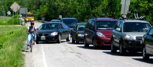


5 Project Area Photos
6 CONCEPTUAL PLANS ALDI DRIVEWAY TO PERFORMANCE DRIVE (STATE PROJECT)

7
8
9
10
11
12
13 CONCEPTUAL PLANS PERFORMANCE DRIVE TO EAST ROAD (TOWN PROJECT)

14
15
16
17 COST ESTIMATE
18 Kocher Drive Streetscape Improvements Construction Estimate State August 214 ITEM NO. DESCRIPTION UNIT VAOT 5 YR AVG PRICE ESTIMATED QUANTITY STATE TOTAL COST STATE CLEARING AND GRUBBING ACRE $12,4..4 $4, EARTH BORROW CY $ $56, SUBBASE OF CRUSHED GRAVEL, COARSE GRADED CY $ $1, BRIDGE RAILING LF $11. 4 $4, " DIA. CPEP (SL) LF $3.9 5 $1, " DIA. CPEP (SL) LF $ $9, " CPEPES EA $ $ " CPEPES EA $ $ PRECAST REINFORCED CONCRETE CATCH BASIN WITH CAST IRON GATE EA $2,75. 4 $11, REMOVAL OF EXISTING CURB LF $ $1, PORTLAND CEMENT CONCRETE SIDEWALK, 5 INCH SY $6.7 1 $6, BITUMINOUS CONCRETE SIDEWALK TON $ $156, MANUFACTURED TERMINAL SECTION, FLARED EA $1,78. 1 $1, GUARDRAIL APPROACH SECTION, GALVANIZED TYPE I EA $1,94. 1 $1, REMOVE AND RESET GUARDRAIL LF $ $1, REMOVAL AND DISPOSAL OF GUARDRAIL LF $2.2 1 $ REMOVAL AND DISPOSAL OF GUIDE POSTS EA $ $ MOBILIZATION/DEMOBILIZATION LS N/A 1 $16, TRAFFIC CONTROL LS N/A 1 $2, " WHITE LINE LF $ $ " YELLOW LINE LF $.6 62 $ " WHITE LINE LF $.9 15 $ " YELLOW LINE LF $.9 5 $ " STOP BAR LF $ $ LETTER OR SYMBOL EA $ $ CROSSWALK MARKING LF $ $ REMOVAL OF PAVEMENT MARKINGS SF $ $ DECIDUOUS TREES EA $ $1, REMOVING SIGNS EA $ $ ERECTING SALVAGED SIGNS EA $ $ REMOVE AND RESET OVERHEAD TRAFFIC SIGN SUPPORT EA $19,1. 1 $19, PEDESTRIAN SIGNALS WITH ACTUATION EA N/A 2 $3,. Total = 25% contingency = 25% Detail Design & Construction Admin = Total within State ROW = $36, $9, $9, $54, NOTE: This is a budgetary cost estimate for Kocher Drive Streetscape Improvements Project as noted on the Conceptual Design Plans dated August 14, 214. This estimate is based on limited available site information. Additional costs could be incurred due to unforeseen issues that would be identified either during the detailed design phase or during construction. Estimated By: Melissa Wasson Date: 12/12/213 Revised: August 14, 214 Checked By: Mark Armbrust, PE Date: 12/12/213
19 Kocher Drive Streetscape Improvements Construction Estimate Town August 214 ITEM NO. DESCRIPTION UNIT VAOT 5 YR AVG PRICE ESTIMATED QUANTITY TOWN TOTAL COST WITHIN TOWN ROW MATLS TOTAL COST WITHIN TOWN ROW LABOR TOTAL COST WITHIN TOWN ROW EQUIPMT TOTAL COST TOWN CLEARING AND GRUBBING ACRE $12,4..5 $. $279. $341. $ SUBBASE OF CRUSHED GRAVEL, COARSE GRADED CY $ $1, $ $43.41 $2, BITUMINOUS CONCRETE SIDEWALK TON $ $23,757.5 $5,482.5 $7,31. $36, DECIDUOUS TREES EA $ $976. $78.8 $195.2 $1,952. Total= $26,. $7,. $8,. $42, 25% contingency = $6,5. $1,75. $2,. $1,5 25% Detail Design & Construction Admin = $6,5. $1,75. $2,. $1,5 Total within Town ROW = $63, NOTE: This is a budgetary cost estimate for Kocher Drive Streetscape Improvements Project as noted on the Conceptual Design Plans dated August 14, 214. This estimate is based on limited available site information. Additional costs could be incurred due to unforeseen issues that would be identified either during the detailed design phase or during construction. Estimated By: Melissa Wasson Date: 12/12/213 Revised: August 14, 214 Checked By: Mark Armbrust, PE Date: 12/12/213
20 APPENDIX
21 Count date Location Counted by Weather Notes 6/19/13 Bennington: US7/VT7A/Kocher Drive BCRC (Chris Manfredi) Sunny 1/2 day of school, no after- school activities Kocher Dr from East US 7 from south VT 7A from West Start Right Thru Left Right Thru Left Right Thru Left Total 9am Peds Bikes Total am Peds Bikes Total am Peds Bikes 1 1 Total pm Peds Bikes Total pm Peds Bikes Total pm Peds Bikes Total pm Peds Bikes 2 2 Total pm Peds Bikes 1 1 Total Total
22 Bennington US- 7 and Kocher Drive Capacity and Delay Analysis September 4, 213 Ian Degutis, Traffic Design Vermont Agency of Transportation Introduction: In response to a request from the Bennington Regional Planning Commission (BRPC), an analysis of the intersection of US- 7 and Kocher Drive in Bennington, VT was performed to assess the traffic impacts associated with the construction of a crosswalk. This signal, MS- 16, is part of a 5- signal coordinated corridor which runs east along Kocher Drive and Northside Drive (both VT- 7A). Analysis: Three concepts were provided to the Agency by the BRPC; Concept 2 was examined in this study, having been selected as the only preferred alternative before the study was requested. Concept 2 involves the removal of two lanes from the intersection and constructing a sidewalk with crosswalk and pedestrian refuge island. Figure 1, below, is extracted from the conceptual layout provided by the BRPC. The crosswalk would run east- west along the northern edge of Kocher Drive, crossing US- 7 at the north side of the intersection. In order to construct the sidewalk the existing dedicated right- turn lane on the eastern leg of Kocher drive would be removed, and the existing through- only lane would become a through- right lane. The refuge island would be constructed in the middle of the north leg of the intersection, US- 7, by removing the existing dedicated right- turn lane and shifting the remaining three lanes to the west, with the right- most lane becoming a through- right lane. Figure 1: Concept 2 in the Area of the Intersection
23 Traffic counts were performed by the Agency of Transportation s Traffic Research section on May 23, 213. These counts were taken after the opening of the newly- constructed segment of the Bennington Bypass, and were done on a school- day to account for that traffic as well. Peak hour volumes and factors were included in the report; AM peak hour is from 7:15-8:15, and PM peak hour is from 3:15-4:15. Pedestrian counts were taken by the BRPC on June 19, 213. The analysis was performed using Synchro 8 software. Only this intersection was analyzed; current traffic volumes for the entire corridor were not available and a complete corridor analysis is beyond the scope of this study. Six scenarios were analyzed, each at for AM and PM peak- hour traffic volumes. The scenarios were: Existing condition Existing geometry with concurrent pedestrian phase Dedicated right- turn lane removed from Kocher Drive westbound only, with concurrent pedestrian phase Dedicated right- turn lane removed from US- 7 southbound only, with concurrent pedestrian phase Dedicated right- turn lanes removed from US- 7 southbound and Kocher Drive westbound (Concept 2), with concurrent pedestrian phase Existing geometry with an exclusive pedestrian phase For each scenario analyzed, AM and PM peak traffic volumes were examined, using the existing cycle lengths for the signal corridor, 76 seconds for the AM peak, and 9 seconds for the PM peak. Synchro was used to optimize the timings for each scenario at the existing cycle lengths. Adding the exclusive pedestrian phase requires a longer cycle length to serve all the phases, so a cycle length of 11 seconds was used. It should be noted that this cycle length represents a minimum for this intersection with an exclusive pedestrian phase, and the effect of this cycle length on the rest of the coordinated corridor was not analyzed as part of this study, so these results cannot be directly compared to other results in the table. The concurrent pedestrian phase was added to Phase 8, the westbound movement on Kocher Drive adjacent to the proposed crosswalk location. For the analysis a Walk time of seven seconds was used, with a Pedestrian Clear time of 25 seconds, both in accordance with guidance in the Manual on Uniform Traffic Control Devices (MUTCD). For the exclusive pedestrian analysis, the same timings were used for the pedestrian phase. An advance pedestrian phase, or delayed green, should be considered. This was not included in this analysis, but would likely have a slight negative impact on delays. Results of these analyses are shown below, in Table 1.
24 Table 1: Intersection Delay and Capacity Cycle Length (s) Max V/C ratio Intersection Delay (s) Intersection LOS ICU ICU LOS Existing Condition AM Peak C.45 A PM Peak C.59 B Existing Geometry; Add Concurrent Pedestrian Phase AM Peak D.45 A PM Peak C.59 B Remove right turn lane from Kocher Drive westbound ; Concurrent Pedestrian Phase AM Peak D.5 A PM Peak D.7 C Remove right turn lane from US- 7 southbound; Concurrent Pedestrian Phase AM Peak E.47 A PM Peak D.63 B Remove right turn lanes from Kocher Drive WB and US- 7 SB; Concurrent Pedestrian Phase AM Peak E.52 A PM Peak D.73 D Existing Geometry; Add Exclusive Pedestrian Phase AM Peak C.45 A PM Peak D.59 B As seen above, adding a concurrent pedestrian phase, even without any geometric changes, doubles the delay at the intersection during the AM peak, and pushes the volume/capacity ratio well above 1. for the same time period. The PM peak experiences an increase in delay and higher v/c ratio as well, but the increase is much less. The variation between the results for the two peak hours is caused by the directional splits in traffic volumes. Adding a concurrent pedestrian phase with sufficient time to allow pedestrians to cross the full width of US- 7 results in removing green time from the through movements on US- 7 and adds it to the through movement on Kocher Drive. The negative effect on intersection is much more pronounced when the predominant traffic movement is on US- 7, in the morning. A complete analysis and potential retiming of the corridor timing would be required as part of the design of any of these alternatives, including comprehensive analysis of delays at all intersections. The Synchro analysis also determines the Levels of Service for each approach. The results of this analysis, for the same six scenarios, are presented below in Table 2. As above, the values for the exclusive pedestrian phase cannot be directly compared to the other values in the table because the cycle length is increased; the impacts of the longer cycle length were not assessed as part of this study.
25 Table 2: Level of Service by Approach Intersection LOS Kocher Drive Eastbound Approach Kocher Drive Westbound Approach US- 7 Northbound Approach US- 7 Southbound Approach LOS Delay LOS Delay LOS Delay LOS Delay LOS Delay Existing Condition AM Peak C 25.1 B 18.2 C 21.8 C 31.8 C 26.8 PM Peak C 28.8 C 24.2 C 24.6 C 32.1 D 35.9 Existing Geometry; Add Concurrent Pedestrian Phase AM Peak D 53.2 B 14.6 B 16. D 43. F 99.1 PM Peak C 31. C 24.9 C 21.1 D 38.9 D 41.2 Remove right turn lane from Kocher Drive westbound ; Concurrent Pedestrian Phase AM Peak D 53.9 B 14.6 B 19.3 D 43. F 99.1 PM Peak D 36.9 C 26.1 C 34. D 42.3 D 48.1 Remove right turn lane from US- 7 southbound; Concurrent Pedestrian Phase AM Peak E 57.6 B 14.6 B 16. D 5. F 16.6 PM Peak D 38.9 C 25. C 21.2 D 38.8 E 71.2 Remove right turn lanes from Kocher Drive WB and US- 7 SB; Concurrent Pedestrian Phase AM Peak E 58.2 B 14.6 B 19.3 D 5. F 16.6 PM Peak D 42.9 C 26.3 D 36.3 D 41.9 E 77.2 Existing Geometry; Add Exclusive Pedestrian Phase AM Peak C 34.7 C 28.8 C 29.9 D 44.3 C 35. PM Peak D 43. D 52.3 C 34.1 C 31.8 E 58.3 From these results it is clear that the most- significant increase in delay is on the US- 7 southbound approach during the AM peak, and that that increase is caused primarily by the addition of the pedestrian phase, not the removal of the dedicated right turn lane. Conclusion: Addition of a crosswalk on the north leg of the intersection of US- 7 and Kocher Drive in Bennington will push the intersection s volume/capacity ratio well above 1. and more than double delay at certain times of day. Delay on the north approach will nearly quadruple during morning peak- hour traffic flows. The lane removal proposed in Concept 2, as provided by the BRPC, has a slight additional negative impact on traffic, but does not make a significant difference to the intersection delay or capacity. Recommendation: If feasible alternatives to the proposed pedestrian crossing at this location exist, they should be pursued first. If no feasible alternative to a crosswalk at this intersection can be identified and a crosswalk is to be constructed at this intersection, VTrans finds no objection to the lane removal as shown in Concept 2.
26 Proper engineering plans will need to be developed for review by the Agency, and the design consultant should be required to perform a corridor timing optimization analysis of the entire coordinated corridor as a part of the design and plan preparation. The pedestrian phase should be concurrent with the adjacent through movement, but should lead the green. All timings and phasing should be in compliance with the MUTCD, VTrans standards and any other applicable standards or guidance.
27 The Vermont Agency of Transportation Traffic Research/Policy Planning & Intermodal Development Turning Movement Report Counter: Miovision camera Counted By: R Gustafson Weather: Sunny, windy Town: Bennington File Name : Merged13 Site Code : Start Date : 5/23/213 Page No : 1 Groups Printed- Auto - Medium - Heavy US 7 from Shaftsbury From North Kocher Dr from East Rd From East US 7 from VT 9 From South VT 7A from VT 67A From West Start Time Left Thru Right Peds Left Thru Right Peds Left Thru Right Peds Left Thru Right Peds Int. Total Factor : AM :15 AM :3 AM :45 AM Total : AM :15 AM :3 AM :45 AM Total : AM :15 AM :3 AM :45 AM Total : AM :15 AM :3 AM :45 AM Total : AM :15 AM :3 AM :45 AM Total : AM :15 AM :3 AM :45 AM Total : PM :15 PM :3 PM :45 PM Total : PM :15 PM :3 PM :45 PM Total : PM :15 PM :3 PM :45 PM Total
28 The Vermont Agency of Transportation Traffic Research/Policy Planning & Intermodal Development Turning Movement Report Counter: Miovision camera Counted By: R Gustafson Weather: Sunny, windy Town: Bennington File Name : Merged13 Site Code : Start Date : 5/23/213 Page No : 2 Groups Printed- Auto - Medium - Heavy US 7 from Shaftsbury From North Kocher Dr from East Rd From East US 7 from VT 9 From South VT 7A from VT 67A From West Start Time Left Thru Right Peds Left Thru Right Peds Left Thru Right Peds Left Thru Right Peds Int. Total Factor : PM :15 PM :3 PM :45 PM Total : PM :15 PM :3 PM :45 PM Total : PM :15 PM :3 PM :45 PM Total Grand Total Apprch % Total % Auto % Auto Medium % Medium Heavy % Heavy
29 The Vermont Agency of Transportation Traffic Research/Policy Planning & Intermodal Development Turning Movement Report Counter: Miovision camera Counted By: R Gustafson Weather: Sunny, windy Town: Bennington File Name : Merged13 Site Code : Start Date : 5/23/213 Page No : 3 US 7 from Shaftsbury Out In Total Right Thru Left Peds VT 7A from VT 67A Out In Total Left Thru Right Peds North 5/23/213 6: AM 5/23/213 5:45 PM Auto Medium Heavy Right Thru Left Peds Out In Total Kocher Dr from East Rd Left Thru Right Peds Out In Total US 7 from VT 9
30 The Vermont Agency of Transportation Traffic Research/Policy Planning & Intermodal Development Turning Movement Report Counter: Miovision camera Counted By: R Gustafson Weather: Sunny, windy Town: Bennington File Name : Merged13 Site Code : Start Date : 5/23/213 Page No : 4 US 7 from Shaftsbury From North Kocher Dr from East Rd From East US 7 from VT 9 From South VT 7A from VT 67A From West Start Time Left Thru Right Peds App. Total Left Thru Right Peds App. Total Left Thru Right Peds App. Total Left Thru Right Peds App. Total Int. Total Peak Hour Analysis From 6: AM to 11:45 AM - Peak 1 of 1 Peak Hour for Entire Intersection Begins at 7:15 AM 7:15 AM :3 AM :45 AM : AM Total Volume % App. Total PHF Auto % Auto Medium % Medium Heavy % Heavy US 7 from Shaftsbury Out In Total Right Thru Left Peds Peak Hour Data VT 7A from VT 67A Out In Total Left Thru Right Peds North Peak Hour Begins at 7:15 AM Auto Medium Heavy Right Thru Left Peds Out In Total Kocher Dr from East Rd Left Thru Right Peds Out In Total US 7 from VT 9
31 The Vermont Agency of Transportation Traffic Research/Policy Planning & Intermodal Development Turning Movement Report Counter: Miovision camera Counted By: R Gustafson Weather: Sunny, windy Town: Bennington File Name : Merged13 Site Code : Start Date : 5/23/213 Page No : 5 US 7 from Shaftsbury From North Kocher Dr from East Rd From East US 7 from VT 9 From South VT 7A from VT 67A From West Start Left Thru Right Peds App. Total Left Thru Right Peds App. Total Left Thru Right Peds App. Total Left Thru Right Peds App. Total Time Int. Total Peak Hour Analysis From 3: PM to 5:45 PM - Peak 1 of 1 Peak Hour for Entire Intersection Begins at 3:15 PM 3:15 PM :3 PM :45 PM : PM Total Volume % App. Total PHF Auto % Auto Medium % Medium Heavy % Heavy US 7 from Shaftsbury Out In Total Right Thru Left Peds Peak Hour Data VT 7A from VT 67A Out In Total Left Thru Right Peds North Peak Hour Begins at 3:15 PM Auto Medium Heavy Right Thru Left Peds Out In Total Kocher Dr from East Rd Left Thru Right Peds Out In Total US 7 from VT 9
Town of Bennington, Vermont Request for Proposals for Design Engineer Bennington Streetscape Improvement Project BENNINGTON STP SDWK(12)
") Town of Bennington, Vermont Request for Proposals for Design Engineer Bennington Streetscape Improvement Project BENNINGTON STP SDWK(12) Contact: Mark Anders, Planner, Local Project Manager Bennington
Town of Bennington, Vermont Request for Proposals for Design Engineer Bennington Streetscape Improvement Project BENNINGTON STP SDWK(12) Contact: Mark Anders, Planner, Local Project Manager Bennington
Evaluation of M-99 (Broad Street) Road Diet and Intersection Operational Investigation
 Road Diet and Intersection Operational Investigation") Evaluation of M-99 (Broad Street) Road Diet and Intersection Operational Investigation City of Hillsdale, Hillsdale County, Michigan June 16, 2016 Final Report Prepared for City of Hillsdale 97 North Broad
Evaluation of M-99 (Broad Street) Road Diet and Intersection Operational Investigation City of Hillsdale, Hillsdale County, Michigan June 16, 2016 Final Report Prepared for City of Hillsdale 97 North Broad
MEMORANDUM. DATE March 1, 2012 TO Town of Milton Mark Abbott, Seth Asante, and Efi Pagitsas Boston Region MPO Staff
 MEMORANDUM DATE March 1, 212 TO Town of Milton FROM RE Mark Abbott, Seth Asante, and Efi Pagitsas Boston Region MPO Staff FFY 211 Safety and Operations Analyses at Selected Boston Region MPO Intersections:
INDUSTRIAL BUILDING 3009 HAWTHORNE ROAD CITY OF OTTAWA TRANSPORTATION OVERVIEW REVISED. Prepared for: Canada Inc.
 INDUSTRIAL BUILDING 3009 HAWTHORNE ROAD CITY OF OTTAWA TRANSPORTATION OVERVIEW REVISED Prepared for: 7849648 Canada Inc. Octiober 1, 2015 114-598 Overview_2.doc D. J. Halpenny & Associates Ltd. Consulting
East 12 th Street Bikeway Feasibility Study
 Final Report East 12 th Street Bikeway Feasibility Study Prepared for: City of Oakland Public Works Agency Submitted by: 180 Grand Avenue, Suite 250 Oakland, CA 94612 Phone: (510) 839-1742; Fax: (510)
TRAFFIC IMPACT ANALYSIS
 TRAFFIC IMPACT ANALYSIS FOR THE CHAMPAIGN UNIT#4 SCHOOL DISTRICT PROPOSED HIGH SCHOOL (SPALDING PARK SITE) IN THE CITY OF CHAMPAIGN Final Report Champaign Urbana Urbanized Area Transportation Study 6/24/2014
BLOSSOM AT PICKENS SIGNALIZED INTERSECTION IMPROVEMENT STUDY
 BLOSSOM AT PICKENS SIGNALIZED INTERSECTION IMPROVEMENT STUDY Class Project Report for ECIV 542 Traffic Engineering Submitted by Omor Sharif Muchun Song Narges Kaveshgar Quyen Pham Chih-Yao Lin Submission
DUNBOW ROAD FUNCTIONAL PLANNING
 DUNBOW ROAD FUNCTIONAL PLANNING Final Report August 3, 216 #31, 316 5th Avenue NE Calgary, AB T2A 6K4 Phone: 43.273.91 Fax: 43.273.344 wattconsultinggroup.com Dunbow Road Functional Planning Final Report
ALLEY 24 TRAFFIC STUDY
 ALLEY 24 TRAFFIC STUDY in City of Frostburg, Maryland January 2013 3566 Teays Valley Road Hurricane, WV Office: (304) 397-5508 www.denniscorporation.com Alley 24 Traffic Study January 2013 Frostburg, Maryland
VT15 / Allen Martin Drive Intersection Scoping Study
 VT15 / Allen Martin Drive Intersection Scoping Study ALTERNATIVES PRESENTATION MEETING DECEMBER 19, 2016 Agenda Study Area Project Background Existing Conditions Identified Issues Proposed Alternatives
Road Conversion Study Plumas Street
 Plumas Street Phase I Submitted to The Regional Transportation Commission of Washoe County Submitted by Zong Tian, Ph.D., P.E. Saeedeh Farivar Haiyuan Li, Ph.D. Center for Advanced Transportation Education
Complete Street Analysis of a Road Diet: Orange Grove Boulevard, Pasadena, CA
 Complete Street Analysis of a Road Diet: Orange Grove Boulevard, Pasadena, CA Aaron Elias, Bill Cisco Abstract As part of evaluating the feasibility of a road diet on Orange Grove Boulevard in Pasadena,
Intersection Traffic Control Feasibility Study
 Intersection Traffic Control Feasibility Study CSAH 9 at CSAH 60 (185th Avenue) Prepared For: Dakota County Transportation Department Western Service Center 14955 Galaxie Avenue, 3rd Floor Apple Valley,
Long Island Rail Road Expansion Project Floral Park to Hicksville
 Long Island Rail Road Expansion Project Floral Park to Hicksville Final Environmental Impact Statement Appendix 1-D Complete Streets Policy Checklist April 2017 0902ML PIN: Project Location: 18A-4 Floral
THIS PAGE LEFT BLANK INTENTIONALLY
 GA SR 25 Spur at Canal Road Transportation Impact Analysis PREPARED FOR GLYNN COUNTY, GEORGIA 1725 Reynolds Street, Suite 300 Brunswick, Georgia 31520 PREPARED BY 217 Arrowhead Boulevard Suite 26 Jonesboro,
APPENDIX A: Complete Streets Checklist DRAFT NOVEMBER 2016
 APPENDIX A: Complete Streets Checklist DRAFT NOVEMBER 2016 Complete Streets Checklist MetroPlan Orlando s Complete Streets Checklist is an internal planning tool for staff to further implementation of
Balancing Operation & Safety for Motorized and Non-Motorized Traffic
 Balancing Operation & Safety for Motorized and Non-Motorized Traffic Brian Willham, PE, PTOE Iowa Director - MOVITE June 30, 2014 Learning Objectives: When & Why should we measure the performance of complete
Los Altos Hills Town Council - June 18, 2015 Palo Alto City Council June 22, AGENDA ITEM #2.B Presentation
 Los Altos Hills Town Council - June 18, 2015 Palo Alto City Council June 22, 2015 AGENDA ITEM #2.B Presentation Previous Presentations Los Altos Hills Town Council in May 2014 and February 2015 Palo Alto
December 4, Merrimac Zoning Board of Appeals 2-8 School Street Merrimac, MA Attn: Kathy Marshall. Dear Board Members:
 December 4, 28 Merrimac Zoning Board of Appeals 2-8 School Street Merrimac, MA 86 Attn: Kathy Marshall RE: RAMSHEAD MERRIMAC, MA Dear Board Members: Bayside Engineering, Inc. has received the MDM Transportation
OFFICE/RETAIL DEVELOPMENT 1625 BANK STREET OTTAWA, ONTARIO TRANSPORTATION BRIEF. Prepared for: Canada Inc.
 OFFICE/RETAIL DEVELOPMENT 1625 BANK STREET OTTAWA, ONTARIO TRANSPORTATION BRIEF Prepared for: 9402209 Canada Inc. December 15, 2015 115-625 Report_2.doc D. J. Halpenny & Associates Ltd. Consulting Transportation
NJDOT Complete Streets Checklist
 Background The New Jersey Department of Transportation s Complete Streets Policy promotes a comprehensive, integrated, connected multi-modal network by providing connections to bicycling and walking trip
Washington St. Corridor Study
 FIGURE 7.17 Bridge Alternatives - Cross Sections 86 Discarded Alternative: Short-Term Bridge Repair Short-term repairs and west bridge span replacement were considered during analysis. Short-term repairs
TRANSPORTATION ANALYSIS REPORT US Route 6 Huron, Erie County, Ohio
 TRANSPORTATION ANALYSIS REPORT US Route 6 Huron, Erie County, Ohio December 12, 2012 Prepared for: The City of Huron 417 Main Huron, OH 44839 Providing Practical Experience Technical Excellence and Client
Clybourn Ave. Protected Bike Lane Study Halsted St. to Division St.
 Clybourn Ave. Protected Bike Lane Study Halsted St. to Division St. Nathan Roseberry, Senior Engineer Pam Broviak, Project Manager July 24, 2014 Agenda Project Goals Existing Roadway Conditions Traffic
James M. Moore, Director of Planning & Building Services, Town of Fairfax. Victory Village Senior Housing Development Traffic Study
 Traffic Study To: From: James M. Moore, Director of Planning & Building Services, Town of Fairfax David Parisi, PE, TE, Parisi Transportation Consulting Date: October 14, 216 Subject: Victory Village Senior
TRAFFIC IMPACT STUDY COMPREHENSIVE UPDATE TOWN OF THOMPSON S STATION, TENNESSEE PREPARED FOR: THE TOWN OF THOMPSON S STATION
 TRAFFIC IMPACT STUDY COMPREHENSIVE UPDATE TOWN OF THOMPSON S STATION, TENNESSEE PREPARED FOR: THE TOWN OF THOMPSON S STATION Transportation Consultants, LLC 1101 17 TH AVENUE SOUTH NASHVILLE, TN 37212
1609 E. FRANKLIN STREET HOTEL TRAFFIC IMPACT STUDY EXECUTIVE SUMMARY
 1609 E. FRANKLIN STREET HOTEL TRAFFIC IMPACT STUDY EXECUTIVE SUMMARY Prepared for: The Town of Chapel Hill Public Works Department Traffic Engineering Division Prepared by: HNTB North Carolina, PC 343
Date: September 7, Project #: Re: Spaulding Youth Center Northfield, NH Property. Traffic Impact Study
 To: Ms. Susan C. Ryan Spaulding Youth Center 72 Spaulding Road Northfield, NH 03276 Date: September 7, 2017 Project #: 52455.00 From: Robin Bousa Director of Transportation Systems Re: Spaulding Youth
Appendix 3 Roadway and Bike/Ped Design Standards
 Appendix 3 Roadway and Bike/Ped Design Standards OTO Transportation Plan 2040 4/20/2017 Page A3-1 Adopted Standards The adopted OTO Design Standards and Major Thoroughfare Plan are contained herein.
Figure 1: Vicinity Map of the Study Area
 ARIZONA TEXAS NEW MEXICO OKLAHOMA May 5, 2016 Mr. Anthony Beach, P.E. BSP Engineers 4800 Lakewood Drive, Suite 4 Waco, Texas 76710 Re: Intersection and Access Analysis along Business 190 in Copperas Cove
Bridging the Gaps in the Emerald Necklace:
 Bridging the Gaps in the Emerald Necklace: Route 9 to Brookline Avenue 1 G.R.8 Engineers Inc. Tony Cennamo Allison Goulet Zach Shapiro Ryan St.Martin BRIDGING THE GAPS IN THE EMERALD NECKLACE: Route 9
Board of Supervisors February 27, 2017
 : Traffic Analysis Results & Draft Conceptual Plan Board of Supervisors February 27, 2017 Transportation Solutions Building Better Communities Presentation Overview Background Summary of Traffic Analysis
Design Criteria. Design Criteria
 F Design Criteria Design Criteria Ministry of Transportation Ministère des Transports DESIGN CRITERIA Page: 1 of 13 WORK PROJECT NO. N/A GO Bloomington Station TYPE OF PROJECT LOCATION Bloomington Road
Highway 111 Corridor Study
 Highway 111 Corridor Study June, 2009 LINCOLN CO. HWY 111 CORRIDOR STUDY Draft Study Tea, South Dakota Prepared for City of Tea Sioux Falls Metropolitan Planning Organization Prepared by HDR Engineering,
TRAFFIC IMPACT STUDY. Creekside Thornton, Colorado. For. August 2015 November 2015 Revised: August Prepared for:
 TRAFFIC IMPACT STUDY For Creekside Thornton, Colorado August 215 November 215 Revised: August 216 Prepared for: Jansen Strawn Consulting Engineers 45 West 2 nd Avenue Denver, Colorado 8223 Prepared by:
REDEVELOPMENT TRAFFIC IMPACT STUDY
 REDEVELOPMENT TRAFFIC IMPACT STUDY For Wendy s Parker, Colorado January 215 Prepared for: Sterling Design Associates, LLC 29 W. Littleton Boulevard #3 Littleton, Colorado 812 Prepared by: 1233 Airport
OTTAWA TRAIN YARDS PHASE 3 DEVELOPMENT CITY OF OTTAWA TRANSPORTATION IMPACT STUDY. Prepared for:
 OTTAWA TRAIN YARDS PHASE 3 DEVELOPMENT CITY OF OTTAWA TRANSPORTATION IMPACT STUDY Prepared for: The Ottawa Train Yards Inc. 223 Colonnade Road South, Suite 212 Nepean, Ontario K2E 7K3 January 17, 2012
Span-Wire Intersections Study SPAN-WIRE INTERSECTIONS STUDY. City of Naples Streets & Stormwater Department 1
 SPAN-WIRE INTERSECTIONS STUDY City of Naples Streets & Stormwater Department 1 Intersection Traffic Control and Design Feasibility Analysis a.k.a Span-Wire Intersections Study Streets & Stormwater Department
Colchester/Riverside/Barrett/ Mill Intersection Study. PAC Meeting #3 September 22, 2016
 Colchester/Riverside/Barrett/ Mill Intersection Study PAC Meeting #3 September 22, 2016 Tonight s Agenda Review Project Purpose and Need Describe short term and long improvements and changes since public
TRAFFIC ASSESSMENT River Edge Colorado
 TRAFFIC ASSESSMENT River Edge Colorado Submitted by: Fehr & Peers 621 17th Street, Ste. 231 Denver, CO 8293 (33) 296-43 December, 21 App. M-2 Traffic Assessment River Edge Colorado December 21 TABLE OF
Simulation Analysis of Intersection Treatments for Cycle Tracks
 Abstract Simulation Analysis of Intersection Treatments for Cycle Tracks The increased use of cycle tracks also known as protected bike lanes has led to investigations of how to accommodate them at intersections.
Traffic Impact Analysis Chatham County Grocery Chatham County, NC
 Chatham County Grocery Chatham County, NC TABLE OF CONTENTS 1. INTRODUCTION... 1 1.1. Location and Study Area... 1 1.2. Proposed Land Use and Access... 2 1.3. Adjacent Land Uses... 2 1.4. Existing ways...
STILLWATER AVENUE CORRIDOR STUDY Old Town, Maine
 Draft Study STILLWATER AVENUE CORRIDOR STUDY Old Town, Maine SUBMITTED TO: BANGOR AREA COMPREHENSIVE TRANSPORTATION SYSTEM SUBMITTED BY: I MAY 23, 2017 DRAFT STILLWATER AVENUE STUDY FINAL REPORT Table
Broad Street Bicycle Boulevard Design Guidelines
 Broad Street Bicycle Boulevard Design Guidelines Building from the strategies introduced in the 2013 Bicycle Transportation Plan and community input received thus far, City Transportation Staff have identified
Typical Cross Section: DOWNTOWN (Observer Highway - 8th Street)
") Typical Cross Section: DOWNTOWN (Observer Highway - 8th Street) DRAFT SEPTEMBER 23, 14 1 Washington Street Typical Block Downtown Typical Block: DOWNTOWN (Observer Highway - 8th Street) New crosswalks
Typical Cross Section: DOWNTOWN (Observer Highway - 8th Street) DRAFT SEPTEMBER 23, 14 1 Washington Street Typical Block Downtown Typical Block: DOWNTOWN (Observer Highway - 8th Street) New crosswalks
TRAFFIC IMPACT STUDY And A TRAFFIC SIGNAL WARRANT ANALYSIS FOR A SENIOR LIVING AND APARTMENT DEVELOPMENT
 TRAFFIC IMPACT STUDY And A TRAFFIC SIGNAL WARRANT ANALYSIS FOR A SENIOR LIVING AND APARTMENT DEVELOPMENT DEERFIELD TOWNSHIP, WARREN COUNTY, OHIO Nantucket Circle and Montgomery Road () Prepared for: ODLE
CITY OF OTTAWA ROADWAY MODIFICATION APPROVAL UNDER DELEGATED AUTHORITY
 RMA-2015-ATM-038 CITY OF OTTAWA ROADWAY MODIFICATION APPROVAL UNDER DELEGATED AUTHORITY DATE: April 22, 2015 SUBJECT Approval of Roadway Modifications Recommended through an Area Traffic Management Study
City of Seattle Edward B. Murray, Mayor
 City of Seattle Edward B. Murray, Mayor Department of Transportation Scott Kubly, Director Eastlake Community Council 117 E Louisa St. #1 Seattle, WA 98102-3278 January 28, 2016 RE: Roosevelt to Downtown
Dr. M.L. King, Jr. Street North Complete Streets Resurfacing Opportunities HOUSING, LAND USE, AND TRANSPORTATION COMMITTEE MARCH 22, 2018
 Dr. M.L. King, Jr. Street North Complete Streets Resurfacing Opportunities HOUSING, LAND USE, AND TRANSPORTATION COMMITTEE MARCH 22, 2018 What s Happening The City plans to mill and resurface Dr. M.L.
Duwamish Way-finding and CTR Report
 V. North Tukwila When the North Tukwila Manufacturing and Industrial Center was designated in 1992 as part of the region s land use and transportation plan, the plan called for the area to set a light-rail
Traffic Operations Memorandum
 Traffic Operations Memorandum MEMORANDUM Date: May 24 th, 2017 To: From: Re: David Stillman, Project Manager, City of Cupertino Brooke DuBose, Project Manager Robert Burchfield, PE Craig Schoenberg, PE
Traffic Impact Study Little Egypt Road Development Denver, North Carolina June 2017
 Traffic Impact Study Little Egypt Road Development Denver, North arolina June 2017 N. Little Egypt Road DQ\ QDQFLQJ VDOHV RU RWKHU SHUIRUPDQFH EDVHG FULWHULD Proposed Site Driveways Site Driveway 1 TRAFFI
APPENDIX 2 LAKESHORE ROAD TRANSPORTATION REVIEW STUDY EXECUTIVE SUMMARY
 APPENDIX 2 LAKESHORE ROAD TRANSPORTATION REVIEW STUDY EXECUTIVE SUMMARY Appendix 2 City of Mississauga Lakeshore Road FINAL REPORT Transportation Review Study December 2010 EXECUTIVE SUMMARY Study Purpose
CAPE COD COMMISSION 3225 MAIN STREET P.O. BOX 226 BARNSTABLE, MA (508) Fax (508) Transportation Safety Report
 Fax (508) Transportation Safety Report") CAPE COD COMMISSION 3225 MAIN STREET P.O. BOX 226 BARNSTABLE, MA 02630 (508) 362-3828 Fax (508) 362-3136 2006 Transportation Safety Report Bourne: Otis Rotary Harwich: Route 137/Route 39 Orleans: Route
CAPE COD COMMISSION 3225 MAIN STREET P.O. BOX 226 BARNSTABLE, MA 02630 (508) 362-3828 Fax (508) 362-3136 2006 Transportation Safety Report Bourne: Otis Rotary Harwich: Route 137/Route 39 Orleans: Route
Summary: Mercer County Princeton Avenue & Spruce Street Study January 2009
 Summary: Several recent studies have assessed potential development and redevelopment opportunities in the Mercer Crossing area of Trenton, Ewing, and Lawrence. This Princeton Avenue and Spruce Street
10.0 CURB EXTENSIONS GUIDELINE
 10.0 CURB EXTENSIONS GUIDELINE Road Engineering Design Guidelines Version 1.0 March 2017 City of Toronto, Transportation Services City of Toronto Page 0 Background In early 2014, Transportation Services
Grant Avenue Streetscape
 REPORT TYPE GOES HERE Grant Avenue Streetscape PREPARED FOR City of Manassas 9027 Center Street Manassas, VA 20110 PREPARED BY 8300 Boone Boulevard Suite 700 Vienna, Virginia 22182 571.389.8121 July 31,
Bellevue Downtown Association Downtown Bike Series
 Bellevue Downtown Association Downtown Bike Series Meeting 2 Franz Loewenherz Andreas Piller Kyle Potuzak Chris Long October 26, 2017 Today s Agenda: 1) Meeting Purpose 2) 9/28 Meeting Recap 3) Candidate
REPORT CONCURRENCE. City Manager. The General Manager concurs with the recommendation of this report.
 COUNCIL REPORT Report No. ENG 08-018 Executive Committee Date: May 0, 018 File No: 5400-1 To: From: Subject: Mayor and Council Purvez Irani, Senior Transportation Engineer Bluejay Street Road Improvements
4. ENVIRONMENTAL IMPACT ANALYSIS 9. TRANSPORTATION AND TRAFFIC
 4. ENVIRONMENTAL IMPACT ANALYSIS 9. TRANSPORTATION AND TRAFFIC 4.9.1 INTRODUCTION The following section addresses the Proposed Project s impact on transportation and traffic based on the Traffic Study
Reference number /VP. Lafayette Downtown Congestion Study - Additional Traffic Analysis
 To James Hinkamp and Tony Coe, City of Lafayette Date January 19, 2017 Copies Reference number 243381/VP From Michael Iswalt and Vanessa Peers File reference 4-05 Subject Lafayette Downtown Congestion
Item No. 14 Town of Atherton
 Item No. 14 Town of Atherton CITY COUNCIL STAFF REPORT CONSENT AGENDA TO: THROUGH: FROM: HONORABLE MAYOR AND CITY COUNCIL GEORGE RODERICKS, CITY MANAGER MICHAEL KASHIWAGI, COMMUNITY SERVICES DIRECTOR MARTY
Cycle Track Design Best Practices Cycle Track Sections
 Design Best Practices Sections It is along street segments where the separation and protection methods of cycle tracks offer more comfort than conventional bicycle lanes, and are more attractive to a wide
Boston Post Road Design Feasibility Study
 Boston Post Road Design Feasibility Study Prepared for the City of Rye Final Report July 18, 2007 Prepared by: Buckhurst Fish & Jacquemart (BFJ) 115 Fifth Avenue New York, NY 10003 www.bfjplanning.com
SCHOOL ROUTE PLAN. For HUNTER S CREEK ELEMENTARY SCHOOL LOCATION 14 ORANGE COUNTY. Prepared for:
 SCHOOL ROUTE PLAN For HUNTER S CREEK ELEMENTARY SCHOOL LOCATION 14 ORANGE COUNTY Prepared for: ORANGE COUNTY SCHOOL ASSESSMENT PROGRAM ORANGE COUNTY PUBLIC WORKS Traffic Engineering Division 42 South John
Appendix T CCMP TRAIL TRAFFIC & TRANSPORTATION DESIGN STANDARD
 Appendix T CCMP 3.3.4 TRAIL TRAFFIC & TRANSPORTATION DESIGN STANDARD 3.3.4 Trail Traffic and Transportation Design Multi-use trails have certain design standards, which vary depending on the agency that
El Camino Real Specific Plan. TAC/CAC Meeting #2 Aug 1, 2018
 El Camino Real Specific Plan TAC/CAC Meeting #2 Aug 1, 2018 Land Use Alternatives Goals and Tradeoffs Parks & open space Housing Retail & services Civic spaces Parking Community gathering spaces 3 Alternatives
METHODOLOGY. Signalized Intersection Average Control Delay (sec/veh)
") Chapter 5 Traffic Analysis 5.1 SUMMARY US /West 6 th Street assumes a unique role in the Lawrence Douglas County transportation system. This principal arterial street currently conveys commuter traffic
Chapter 5 Traffic Analysis 5.1 SUMMARY US /West 6 th Street assumes a unique role in the Lawrence Douglas County transportation system. This principal arterial street currently conveys commuter traffic
Construction Specifications Manual
 Isle of Wight County Pedestrian and Bicycle Master Plan Construction Specifications Manual Adopted August 20, 2009 Introduction The Isle of Wight County Pedestrian and Bicycle Facilities Master Plan was
Clackamas County Comprehensive Plan
 ROADWAYS The County s road system permits the movement of goods and people between communities and regions, using any of a variety of modes of travel. Roads provide access to virtually all property. They
East Downtown Tax Increment Reinvestment Zone (TIRZ) No. 15 Infrastructure Assessment Study
 No. 15 Infrastructure Assessment Study") East Downtown Tax Increment Reinvestment Zone (TIRZ) No. 15 Infrastructure Assessment Study Houston, TX Technical Memorandum April 15 th, 2009 Prepare by: 2950 North Loop West, Ste. 900 Houston, TX 77092
East Downtown Tax Increment Reinvestment Zone (TIRZ) No. 15 Infrastructure Assessment Study Houston, TX Technical Memorandum April 15 th, 2009 Prepare by: 2950 North Loop West, Ste. 900 Houston, TX 77092
PROJECT NO. 093 MA 199 H C. FEDERAL NO. xxxx WIKIEUP-WICKENBURG-PHOENIX HIGHWAY TEGNER STREET, ALTERNATIVE 10 PROJECT IMPROVEMENT
 PROJECT NO. 093 MA 199 H 5807 01C FEDERAL NO. xxxx WIKIEUP-WICKENBURG-PHOENI HIGHWAY TEGNER STREET, ALTERNATIVE 10 PROJECT IMPROVEMENT (INTERSECTION IMPROVEMENT) US 93/US 60 FINAL PROJECT ASSESSMENT April
HILTON GARDEN INN HOTEL HOTEL EXPANSION 2400 ALERT ROAD, OTTAWA TRANSPORTATION BRIEF. Prepared for:
 HILTON GARDEN INN HOTEL HOTEL EXPANSION 2400 ALERT ROAD, OTTAWA TRANSPORTATION BRIEF Prepared for: Bona Building & Management Co. Ltd. Place Vanier, 333 North River Road Vanier, Ontario K1L 8B9 October
Addendum to Mitigated Negative Declaration
 Addendum Date: Case No.: 2014.1499E Project Title: (MDSP) - Mission Valencia Green Gateway Streetscape Project Original: 2008.1075, MDSP Mitigated Negative Declaration Project Sponsor: Charlie Ream, San
MAG Town of Cave Creek Bike Study Task 6 Executive Summary and Regional Significance Report
 Page 1 MAG Town of Cave Creek Bike Study Task 6 Executive Summary and Regional Significance Report August 1, 2012 MAG Project #481 Page 2 Task 6 Executive Summary and Regional Significance Report Introduction
Pearl Street / Prospect Street / Colchester Avenue Intersection Scoping Study. April 11, 2013 Steering Committee Meeting #3
 Pearl Street / Prospect Street / Colchester Avenue Intersection Scoping Study April 11, 2013 Steering Committee Meeting #3 Meeting Agenda Welcome & Introductions Review Project Purpose & Needs Results
HOLIDAY INN HOTEL 235 KING EDWARD AVENUE CITY OF OTTAWA TRANSPORTATION BRIEF. Prepared for:
 HOLIDAY INN HOTEL 235 KING EDWARD AVENUE CITY OF OTTAWA TRANSPORTATION BRIEF Prepared for: Momentum Planning & Communications 1165 Greenlawn Crescent Ottawa, ON K1L 6C2 June 29, 2015 115-618 Brief_1.doc
TRANSPORTATION FACILITY PLANNING Waugh Chapel Road Maytime Drive to New Market Lane
 July 24, 2018 TRANSPORTATION FACILITY PLANNING Waugh Chapel Road Maytime Drive to New Market Lane DPWandYOU.com Making a difference, together Meeting Agenda Purpose of the project Overview of work conducted
MEETING FACILITY 2901 GIBFORD DRIVE CITY OF OTTAWA TRANSPORTATION BRIEF. Prepared for: Holiday Inn Express 2881 Gibford Drive Ottawa, ON K1V 2L9
 MEETING FACILITY 2901 GIBFORD DRIVE CITY OF OTTAWA TRANSPORTATION BRIEF Prepared for: Holiday Inn Express 2881 Gibford Drive Ottawa, ON K1V 2L9 December 18, 2012 112-566 Brief_1.doc D. J. Halpenny & Associates
CITY OF OAKLAND. 27th Street Bikeway Feasibility and Design. Final Report (v3) March 23, Kimley-Horn and Associates, Inc.
 March 23, Kimley-Horn and Associates, Inc.") CITY OF OAKLAND 27th Street Bikeway Feasibility and Design Final Report (v3) March 23, 2007 PREPARED BY: Kimley-Horn and Associates, Inc. Table of Contents 1. Introduction 3 2. 27 th Street/Bay Place Corridor
CITY OF OAKLAND 27th Street Bikeway Feasibility and Design Final Report (v3) March 23, 2007 PREPARED BY: Kimley-Horn and Associates, Inc. Table of Contents 1. Introduction 3 2. 27 th Street/Bay Place Corridor
Date: April 4, Project #: Re: A Street/Binford Street Traffic/Intersection Assessment
 To: Peter Cavanaugh General Electric From: David Bohn, PE Ryan White, PE Date: April 4, 217 Project #: 13421. Re: / Traffic/Intersection Assessment Consistent with the Cooperation Agreement between the
FAIRFIELD INN & SUITES HOTEL 135 THAD JOHNSON PRIVATE OTTAWA TRANSPORTATION BRIEF. Prepared for:
 FAIRFIELD INN & SUITES HOTEL 135 THAD JOHNSON PRIVATE OTTAWA TRANSPORTATION BRIEF Prepared for: Bona Building & Management Co. Ltd. Place Vanier, 333 North River Road Vanier, Ontario K1L 8B9 August 12,
Marina Loft (DRC 51-R-12)
") Marina Loft (DRC 51-R-12) traffic study prepared for: Cymbal Development OCtober 2012 Traf Tech October 1, 2012 Mr. Asi Cymbal - President Cymbal Development 3470 North Miami Avenue Upper Suite Miami,
Marina Loft (DRC 51-R-12) traffic study prepared for: Cymbal Development OCtober 2012 Traf Tech October 1, 2012 Mr. Asi Cymbal - President Cymbal Development 3470 North Miami Avenue Upper Suite Miami,
INDUSTRIAL BUILDING 1660 COMSTOCK ROAD CITY OF OTTAWA TRANSPORTATION OVERVIEW. Prepared for:
 INDUSTRIAL BUILDING 1660 COMSTOCK ROAD CITY OF OTTAWA TRANSPORTATION OVERVIEW Prepared for: Simluc Contractors Limited 2550 Blackwell Street, Ottawa K1B 5R1 October 18, 2013 113-584 Overview_1.doc D. J.
WELCOME Public Information Centre
 WELCOME Public Information Centre Fernforest Drive Brampton Soccer Centre Community Room #2 Tuesday January 19, 2016 6:30 p.m.to 9:00 p.m. Please sign in Neighbourhood Traffic Calming Guide Background
Polk Streetscape Project
 What is this project? The Polk Streetscape Project is an effort to improve safety for everyone traveling on Polk Street between Union and McAllister streets. Also included in this project are paving, sewer
Newport City Thoroughfare Plan
 Newport City Thoroughfare Plan Summary This plan is intended to review and make recommendations for Newport City s thoroughfare network, in consideration of the full range of uses of the city s streets.
Glenn Avenue Corridor Traffic Operational Evaluation
 Glenn Avenue Corridor Traffic Operational Evaluation PREPARED FOR: THE CITY OF AUBURN PREPARED BY: DECEMBER 2007 Glenn Avenue Corridor Study--Auburn, Alabama TABLE OF CONTENTS Introduction... 1 Background
Welcome to the Open House
 Leslie Street Between 19 th Avenue and Stouffville Road Addendum to Class Environmental Assessment Study Welcome to the Open House Please sign in at the front desk. March 28, 2017 Richmond Green Sports
TRAFFIC STUDY GUIDELINES Clarksville Street Department
 TRAFFIC STUDY GUIDELINES Clarksville Street Department 9/1/2009 Introduction Traffic studies are used to help the city determine potential impacts to the operation of the surrounding roadway network. Two
Small Area Study U.S. Route 220 and VA Route 615 Intersection. Bath County, Virginia
 Small Area Study U.S. Route 220 and VA Route 615 Intersection Bath County, Virginia Prepared by the Central Shenandoah Planning District Commission Final Report February 2018 Table of Contents 1. INTRODUCTION...
Traffic Control Inspection Checklist Segment:
 Traffic Control Inspection Checklist Segment: Simon Contractors Simon Contractors Originator: Description Reviewed by: Initials Date Distribution: Traffic Quality Manager, Site Assistant Traffic Manager
Overview. Illinois Bike Summit IDOT Complete Streets Policy Presentation. What is a Complete Street? And why build them? And why build them?
 Overview Illinois Bike Summit IDOT Complete Streets Policy Presentation Aren Kriks, P.E. District One Bicycle Coordinator and Bureau of Programming Project Engineer History of Complete Streets IDOT Policy
AGENDA ITEM 6 D THOMASVILLE ROAD (HERMITAGE BOULEVARD TO LIVE OAK PLANTATION ROAD) ROADWAY SAFETY AUDIT
 ROADWAY SAFETY AUDIT") May 15, 2018 AGENDA ITEM 6 D THOMASVILLE ROAD (HERMITAGE BOULEVARD TO LIVE OAK PLANTATION ROAD) ROADWAY SAFETY AUDIT TYPE OF ITEM: Discussion STATEMENT OF ISSUE The Florida Department of Transportation
May 15, 2018 AGENDA ITEM 6 D THOMASVILLE ROAD (HERMITAGE BOULEVARD TO LIVE OAK PLANTATION ROAD) ROADWAY SAFETY AUDIT TYPE OF ITEM: Discussion STATEMENT OF ISSUE The Florida Department of Transportation
North Avenue Corridor Study
 North Avenue Corridor Study Advisory Committee Meeting #6 July 1, 2014 Agenda Concept Revisions based on Advisory Committee feedback Review of New Concept Scoring & Costs Concept Discussion/Questions Voting:
Lake Whitney Elementary School
 Lake Whitney Elementary School SCHOOL ROUTE PLAN For LAKE WHITNEY ELEMENTARY SCHOOL LOCATION 18 ORANGE COUNTY Prepared for: ORANGE COUNTY SCHOOL ASSESSMENT PROGRAM ORANGE COUNTY PUBLIC WORKS Traffic Engineering
Bicycle and Pedestrian Facilities Toolbox (Excerpt from Figure 3.1)
") Appendix B Neighborhood Connections Summaries This Appendix is a supplement to the information presented in Chapter 3 Connect People. The Appendix includes a summary or profile for each of the proposed
Appendix B Neighborhood Connections Summaries This Appendix is a supplement to the information presented in Chapter 3 Connect People. The Appendix includes a summary or profile for each of the proposed
INDEX. Geometric Design Guide for Canadian Roads INDEX
 Acceleration lane, see Lanes, Acceleration Access, 8.1 Access Management and Functional Classification 8.2 Access Management by Design Classification 8.3 Access Configuration 8.4 Building Set-Back Guidelines
Project Report. South Kirkwood Road Traffic Study. Meadows Place, TX October 9, 2015
 Meadows Place, TX October 9, 2015 Contents 1 Introduction... 1 2 Data Collection... 1 3 Existing Roadway Network... 2 4 Traffic Volume Development... 2 5 Warrant Analysis... 3 6 Traffic Control Alternative
01. VICINITY OF GREENBRAE POC: EXISTING CONDITIONS
 01. VICINITY OF GREENBRAE POC: EXISTING CONDITIONS Existing Bus Stop Existing US101 On-ramp Existing POC Old Redwood Highway Rich Street City ROW Environmental Study Limit Industrial Way NO DESIGNATED