Transportation Evaluation Criteria Analysis. Scenario: _A Croton to Longleaf. Does the proposal increase or decrease or have no effect on the
|
|
|
- Rhoda O’Brien’
- 5 years ago
- Views:
Transcription


1 15


2 16

3 17


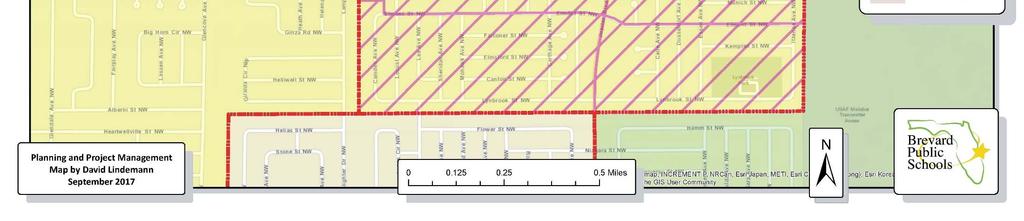
4 Transportation Evaluation Criteria Analysis Scenario: _A Croton to Longleaf Does the scenario increase or decrease or have no effect on the number of students within a 2 mile walking radius? The 6 students living on Tabitha Court will now walk to Longleaf Elementary instead of ride a bus to Croton. Are there special considerations relating to transportation that should be considered (like interchange crossing or railroad crossing type of issues)? No special considerations Does the proposal increase or decrease or have no effect on the number of student s bused pass another school? Instead of these students being bussed through Sable and Creel s attendance zones and south of those schools to get to Croton, they will now be directly into Longleaf s zone but will travel North past Sherwood. Does the scenario create, eliminate or have no effect on a bus ride that is longer than 45 minutes? No effect. 18


5 Staff Recommendation 19

6 Staff Recommendation 20
7 Transportation Evaluation Criteria Analysis Scenario: _B1 Kennedy to McNair Does the scenario increase or decrease or have no effect on the number of students within a 2 mile walking radius? No as the same 40 students that walk to Kennedy would now walk to McNair. Are there special considerations relating to transportation that should be considered (like interchange crossing or railroad crossing type of issues)? No special considerations Does the proposal increase or decrease or have no effect on the number of student s bused pass another school? No change Does the scenario create, eliminate or have no effect on a bus ride that is longer than 45 minutes? No effect. 21

8 25


9 26
10 Transportation Evaluation Criteria Analysis Scenario: _D Meadowlanes to Discovery Does the scenario increase or decrease or have no effect on the number of students within a 2 mile walking radius? There will be 85 more walking students for Discovery Elementary that used to ride a bus to Meadowlane. Are there special considerations relating to transportation that should be considered (like interchange crossing or railroad crossing type of issues)? No special considerations Does the proposal increase or decrease or have no effect on the number of student s bused pass another school? No change Does the scenario create, eliminate or have no effect on a bus ride that is longer than 45 minutes? No effect. 27


11 28
12 29
13 Transportation Evaluation Criteria Analysis Scenario: _E Cambridge and Endeavour to Saturn Does the scenario increase or decrease or have no effect on the number of students within a 2 mile walking radius? In the North section of the proposed change, all of the Cambridge and Endeavour students are in the walk zones for those schools, but they are outside the 2 mile limit for Saturn due to limitations in the road network and will need to be bussed. (104 Students). In the Southern portion of the proposed change 34 Endeavour students that ride the bus to Endeavour will become walking students for Saturn. The net change is an increase of 138 walking students Are there special considerations relating to transportation that should be considered (like interchange crossing or railroad crossing type of issues)? For some of the students south of 520 we may need to evaluate to add Walking Hazards on Range and Burnett roads. If those areas qualify for a hazard approximately 10 students would need bus transportation Does the proposal increase or decrease or have no effect on the number of student s bused pass another school? No change Does the scenario create, eliminate or have no effect on a bus ride that is longer than 45 minutes? No effect. 30


14 31


15 32
16 Transportation Evaluation Criteria Analysis Scenario: _F6 Melbourne High Boundary Change (with Grandfathered Current Students) Does the scenario increase or decrease or have no effect on the number of students within a 2 mile walking radius? No effect on the number of students within a 2 mile walking zone. Are there special considerations relating to transportation that should be considered (like interchange crossing or railroad crossing type of issues)? No special considerations. Does the proposal increase or decrease or have no effect on the number of student s bused pass another school? No change Does the scenario create, eliminate or have no effect on a bus ride that is longer than 45 minutes? One bus route over 45 minutes long would be reduced significantly in duration. 33


17 34

18 35
19 Transportation Evaluation Criteria Analysis Scenario: _G Central Middle School to Southwest Does the scenario increase or decrease or have no effect on the number of students within a 2 mile walking radius? Adds 11 students within the 2 mile walk zone. Are there special considerations relating to transportation that should be considered (like interchange crossing or railroad crossing type of issues)? No special considerations. Does the proposal increase or decrease or have no effect on the number of student s bused pass another school? No change. Does the scenario create, eliminate or have no effect on a bus ride that is longer than 45 minutes? No change. 36
Transportation Evaluation Criteria Analysis. Scenario: _A Croton to Longleaf. Does the proposal increase or decrease or have no effect on the
 15 16 17 Transportation Evaluation Criteria Analysis Scenario: _A Croton to Longleaf Does the scenario increase or decrease or have no effect on the number of students within a 2 mile walking radius? The
Facilities Services. School Board Workshop July 10, 2018
 Facilities Services School Board Workshop July 10, 2018 Outline Capacity Planning 2 Status of February 2017 Plan 2018-19 Student Accommodation Plan Elementary Secondary Vacant Properties Impact Fees Surtax
Vicinity Map. Proposed Roosevelt Street Sidewalk Project OVERLAND ROAD TO CASSIA STREET W ROSE HILL ST W ALBION ST S OWYHEE ST W CASSIA ST
 Vicinity Map W ROSE HILL ST Cassia Park W CAMAS ST LEGEND W ALBION ST S ROOSEVELT ST W CASSIA ST Sacred Heart W KOOTENAI ST Monroe Elementary S OWYHEE ST South Junior High S SHOSHONE ST Project area Bus
SUBJECT: Board Approval: 4/29/04
 1255 Imperial Avenue, Suite 1000 San Diego, CA 92101-7490 619/231-1466 FAX 619/234-3407 Policies and Procedures No. 38 SUBJECT: Board Approval: 4/29/04 OUT-OF-DIRECTION BUS ROUTINGS PURPOSE: To establish
Orange Center Elementary School
 Drag and drop pic and stretch/crop to the limits of the blue rectangle (delete this text box) Orange Center Elementary School Drag and drop pic and stretch/crop to the limits of the blue rectangle (delete
Safe Routes to School Travel Plan 2011
 Safe Routes to School Travel Plan 2011 Barley Sheaf Elementary School Barley Sheaf School 80 Barley Sheaf Road Flemington, NJ 08822 Grades: K-4 Introduction Barley Sheaf School is a K-4 elementary school
Approve the following nominations for reappointment on annual contract for the school year:
 NSTRUCTONAL PERSONNEL NOMNATONS All annual contract teacher nominations for appointment or reappointment for the 2010-11 school year are contingent upon completion of certification requirements including,
Ujari Mohite. Vijay Mahal and Vincent Sanders. Revised Ridership Forecasts for the Uptown DBL project. Date: August 17, 2015 INTRODUCTION/SUMMARY:
 To: From: Subject: Ujari Mohite Vijay Mahal and Vincent Sanders Revised Ridership Forecasts for the Uptown DBL project Date: August 17, 2015 INTRODUCTION/SUMMARY: This memorandum presents updated ridership
Traffic Impact Memorandum. May 22, 2018
 BISHOP PROFESSIONAL DEVELOPMENT BUILDING Proposed Land-use Change & Parking Modification 3601 SW 31st Street Topeka, Kansas 66614 CFS Project No. 185077 Traffic Impact Memorandum May 22, 2018 Prepared
Appendices. Atkins SBL Forecasting Report 54
 Appendices Atkins 5103087 SBL 54 Atkins 5103087 SBL 55 Appendix A. Local Trip End Generation Rates A.1. A.1.1. Trip Rates The trip rates calculated from TRICS v6.8.1 are presented below for each of the
CITY OF LOS ANGELES INTER-DEPARTMENTAL CORRESPONDENCE SUBJECT: UPDATE ON DODGER STADIUM SHUTTLE SERVICE FOR THE 2009 BASEBALL SEASON (CF )
") CITY OF LOS ANGELES INTER-DEPARTMENTAL CORRESPONDENCE Date: January 14, 2009 To: The Honorable City Council C/o City Clerk, Room 395, City Hall Attention: Wendy Greuel, Chair Transportation Committee From:
CITY OF LOS ANGELES INTER-DEPARTMENTAL CORRESPONDENCE Date: January 14, 2009 To: The Honorable City Council C/o City Clerk, Room 395, City Hall Attention: Wendy Greuel, Chair Transportation Committee From:
Drag and drop pic and stretch/crop to the limits of the blue rectangle (delete this text box) Maxey Elementary School
 Maxey Elementary School") Drag and drop pic and stretch/crop to the limits of the blue rectangle (delete this text box) Maxey Elementary School SCHOOL ROUTE PLAN For MAXEY ELEMENTARY SCHOOL LOCATION 33 ORANGE COUNTY Prepared for:
Drag and drop pic and stretch/crop to the limits of the blue rectangle (delete this text box) Maxey Elementary School SCHOOL ROUTE PLAN For MAXEY ELEMENTARY SCHOOL LOCATION 33 ORANGE COUNTY Prepared for:
ORDINANCE NO AN ORDINANCE MAKING CERTAIN FINDINGS AND ESTABLISHING THE MALL REDEVELOPMENT DISTRICT
 Introduced: January 20, 2015 Passed: January 20, 2015 Published: January 23, 2015 ORDINANCE NO. 2015-2 AN ORDINANCE MAKING CERTAIN FINDINGS AND ESTABLISHING THE MALL REDEVELOPMENT DISTRICT WHEREAS, K.S.A.
MORNING TRAFFIC (Wed, Fri, Sat, Sun) 2018 CrossFit Rusk Gate
 2018 CrossFit Rusk Gate") MORNING TRAFFIC (Wed, Fri, Sat, Sun) 2018 CrossFit Rusk Gate No fees are being collected at the parking booths. Vehicles will be able to free flow passed the booths. This should significantly decrease
MORNING TRAFFIC (Wed, Fri, Sat, Sun) 2018 CrossFit Rusk Gate No fees are being collected at the parking booths. Vehicles will be able to free flow passed the booths. This should significantly decrease
3.0 Future Conditions
 3.0 Future Conditions In order to be able to recommend appropriate improvements to the transportation system of the Town, it is important to first understand the nature and volume of traffic that is expected
Durrance Elementary School
 Durrance Elementary School SCHOOL ROUTE PLAN For DURRANCE ELEMENTARY SCHOOL LOCATION 9 ORANGE COUNTY Prepared for: ORANGE COUNTY SCHOOL ASSESSMENT PROGRAM ORANGE COUNTY PUBLIC WORKS Traffic Engineering
4. ENVIRONMENTAL IMPACT ANALYSIS 9. TRANSPORTATION AND TRAFFIC
 4. ENVIRONMENTAL IMPACT ANALYSIS 9. TRANSPORTATION AND TRAFFIC 4.9.1 INTRODUCTION The following section addresses the Proposed Project s impact on transportation and traffic based on the Traffic Study
Appendix C. NORTH METRO STATION AREA TRAFFIC IMPACT STATEMENT 88th Avenue Station
 Appendix C NORTH METRO STATION AREA TRAFFIC IMPACT STATEMENT 88th Avenue Station Prepared for: Regional Transportation Department and URS Corporation as part of the North Metro EIS David Evans and Associates,
4 DISRUPTION MANAGEMENT PLAN HIGHWAY 7 RAPIDWAY CONSTRUCTION BETWEEN BAYVIEW AVENUE AND WARDEN AVENUE TOWNS OF MARKHAM AND RICHMOND HILL
 4 DISRUPTION MANAGEMENT PLAN HIGHWAY 7 RAPIDWAY CONSTRUCTION BETWEEN BAYVIEW AVENUE AND WARDEN AVENUE TOWNS OF MARKHAM AND RICHMOND HILL The Transportation Services Committee recommends the adoption of
Lawrence Safe Routes to School. Community Meeting January 14, 2015
 Lawrence Safe Routes to School Community Meeting January 14, 2015 Safe Routes to School The 6 E s Education Encouragement Enforcement Engineering Evaluation Equity What are the elements of a SRTS plan?
September 20, 2016 L Taraval Rapid Project SFMTA Board of Directors Meeting
 September 20, 2016 L Taraval Rapid Project SFMTA Board of Directors Meeting WHY TARAVAL STREET L TARAVAL PROJECT GOALS 1. Improve state of good repair of our transit system Track and overhead replacement
Meadow Woods Elementary School
 Drag and drop pic and stretch/crop to the limits of the blue rectangle (delete this text box) Meadow Woods Elementary School Drag and drop pic and stretch/crop to the limits of the blue rectangle (delete
System Operating Limit Definition and Exceedance Clarification
 System Operating Limit Definition and Exceedance Clarification The NERC defined term System Operating Limit (SOL) is used extensively in the NERC Reliability Standards; however, there is much confusion
APPENDIXB. Traffic Operations Technical Memorandum
 APPENDIXB Traffic Operations Technical Memorandum Environmental Assessment - Lincoln County, SD 85 th Street: Sundowner Avenue to Louise Avenue November 2017 MEMORANDUM Transportation Jim Kollbaum, PE
Indiana Electricity Projections: The 2018 Forecast Update
 Indiana Electricity Projections: The 2018 Forecast Update State Utility Forecasting Group The Energy Center at Discovery Park Purdue University West Lafayette, Indiana October 2018 Summary This report
Bluffdale/ UDOT South High-T Intersection Project Type Operations
 Bluffdale/ UDOT 14600 South High-T Intersection Project Type Operations 14600 South and Redwood Road $ 600,000 $ 550,000 This project is to install a new High-T intersection at Redwood Road and 14600 South
TOWN OF CHAPEL HILL POLICY AND PROCEDURES FOR TRAFFIC CALMING MEASURES
 TOWN OF CHAPEL HILL POLICY AND PROCEDURES FOR TRAFFIC CALMING MEASURES (Adopted by the Town Council on June 30, 2004) (Revised December 6, 2010) (Revised February 8, 2016) POLICY AND PROCEDURES FOR TRAFFIC
REYKJAVÍK - NEW MOBILITY OPTIONS
 25. OKTÓBER 2017 REYKJAVÍK - NEW MOBILITY OPTIONS ÞORSTEINN R. HERMANNSSON City of Reykjavik Director of Transportation REYKJAVIK CAPITAL AREA EXPECTED GROWTH 2015-2040 70.000 How will we travel? How should
Subject: Solberg Avenue / I-229 Grade Separation: Traffic Analysis
 MEMORANDUM Transportation Bill Troe, AICP Jason Carbee, AICP 12120 Shamrock Plaza Suite 300 Omaha, NE 68154 (402) 334-8181 (402) 334-1984 (Fax) To: Project File Date: Subject: Solberg Avenue / I-229 Grade
Milton Road Bus Stop and Crossings Workshop WSP. 19th September 2017
 Bus Stop and Crossings Workshop WSP 19th September 2017 Workshop Aims Task 1: Identify preferences for bus stop designs relative to: (a) Ranking preference between 4 possible bus stop designs on the narrower
Frequently asked questions (FAQ) about a borough-wide 20 mph speed limit
 about a borough-wide 20 mph speed limit") Frequently asked questions (FAQ) about a borough-wide 20 mph speed limit February 2013 1. Is it safer to drive at 20 mph? Yes. According the Royal Society for Prevention of Accidents (RoSPA) if a pedestrian
Frequently asked questions (FAQ) about a borough-wide 20 mph speed limit February 2013 1. Is it safer to drive at 20 mph? Yes. According the Royal Society for Prevention of Accidents (RoSPA) if a pedestrian
Approve the following nominations for reappointment on annual contract for the school year:
 NSTRUCTONAL PERSONNEL NOMNATONS All annual contract teacher nominations for appointment or reappointment for the 2014-15 school year are contingent upon completion of certification requirements including,
Dutchess County Division of Mass Transit. Proposed LOOP Bus Service Changes. Public Information Meeting: January 8,
 Proposed LOOP Bus Service Changes Public Information Meeting: January 8, 2009 1 1 30 Fixed Routes Demand Response Services - Dial-A-Ride program - ADA complementary service Operating Budget - 2008: $7.7
Approve the following nominations for reappointment on annual contract for the school year:
 NSTRUCTONAL PERSONNEL NOMNATONS All annual contract teacher nominations for appointment or reappointment for the 2014-15 school year are contingent upon completion of certification requirements including,
APPENDIX I TRANSIT TRAVEL TIME SAVINGS
 APPENDIX I TRANSIT TRAVEL TIME SAVINGS McCORMICK RANKIN CORPORATION 1145 Hunt Club Road, suite 300 Ottawa, Ontario, K1V 0Y3 Tel: (613)736-7200 Fax: (613) 736-8710 E-mail: mrc@mrc.ca Website: www.mrc.ca
Trip Generation for an averaged sized elementary school in Provo, Utah
 Trip Generation for an averaged sized elementary school in Provo, Utah Brigham Young University s ITE student chapter conducted a Trip Generation Study to determine the number of trips generated by an
Public transport and town planning from a retroactive point of view C. Wallstrom, S. Johansson et al
 Public transport and town planning from a retroactive point of view C. Wallstrom, S. Johansson et al The aim of this project is to estimate the effect of town planning on traffic volumes and modal split
HIGHWAY 401 WIDENING SECOND LINE WEST STRUCTURE
 HIGHWAY 401 WIDENING SECOND LINE WEST STRUCTURE Public Meeting November 16, 2011 OVERVIEW BACKGROUND DISCUSSION ITEMS TRAFFIC ANALYSIS CYCLIST / PEDESTRIAN CONNECTION BACKGROUND February 1982 Ministry
CITY OF ELK GROVE CITY COUNCIL STAFF REPORT
 CITY OF ELK GROVE CITY COUNCIL STAFF REPORT AGENDA ITEM NO. 10.1 AGENDA TITLE: Provide Guidance on Proposed e-tran Service Modifications MEETING DATE: PREPARED BY: DEPARTMENT HEAD: Jean Foletta, Transit
BURGAS INTEGRATED PUBLIC TRANSPORT PROJECT. Information day, 5 th July 2011, Burgas
 BURGAS INTEGRATED PUBLIC TRANSPORT PROJECT Information day, 5 th July 2011, Burgas BRT TECHNICAL DESIGN TENDER Preliminary tender specifications and requirements Overview 1 Burgas BRT concept 2 Main outputs
 TRAFFIC IMPACT STUDY CANYON HILLS PROJECT LOS ANGELES, CALIFORNIA INTRODUCTION This traffic analysis has been conducted to identify and evaluate the potential traffic impacts of the proposed Canyon Hills
WHITE PAPER: TRANSIT SERVICE FOR SOUTH SHAGANAPPI
 9/27/2012 TRANSIT PLANNING WHITE PAPER: TRANSIT SERVICE FOR SOUTH SHAGANAPPI 2012 Calgary Transit 1 Table of Contents Purpose... 3 Area of Change... 3 Background... 3 Access to destinations... 5 Connecting
Contents. Champaign-Urbana Mass Transit District Stop Placement Guidelines
 Contents Champaign-Urbana Mass Transit District Introduction... 1 Stop Spacing... 2 Rural... 2 Low Density Suburban... 2 General Urban... 2 Urban Core... 2 Operational Safety... 3 Stop Placement... 4 Nearside
Eaton XC Invitational Coaches Update September 14, 2017 PARKING INFORMATION
 Eaton XC Invitational Coaches Update September 14, 2017 Please read prior to arriving at the Eaton Invitational on Saturday! PARKING INFORMATION Bus Driver Information 1.) All school busses must drop off
Traffic Circulation Study for Neighborhood Southwest of Mockingbird Lane and Airline Road, Highland Park, Texas
 ARIZONA TEXAS NEW MEXICO OKLAHOMA February 13, 2015 Mr. Meran Dadgostar P.E., R.S. Town of Highland Park 4700 Drexel Dr. Highland Park, Texas 75205 Re: Traffic Circulation Study for Neighborhood Southwest
Welcome to the Sellwood Bridge Project Open House!
 Welcome to the Sellwood Bridge Project Open House! 5:30 7:30 pm Please sign in here Information stations and project staff are located throughout the room. Goals for Tonight s Meeting: Learn how the Preferred
FEASIBLE SOLUTIONS FOR REDUCING TRAFFIC FROM MEERAMAKKAM MOSQUE JUNCTION TO THOPAWANA TEMPLE AREA IN KANDY
 FEASIBLE SOLUTIONS FOR REDUCING TRAFFIC FROM MEERAMAKKAM MOSQUE JUNCTION TO THOPAWANA TEMPLE AREA IN KANDY A.M.Z. Zimar 1*, P. Sanjeevan 2 1 South Eastern University of Srilanka, Srilanka 2 Central Engineering
Pattullo Bridge Replacement Project Community Connections Phase 2 Consultation. Appendix 3: Open House Display Boards
 Replacement Project Community Connections Phase 2 Consultation Appendix 3: Open House Display Boards November 2016 Welcome! Welcome to the Replacement Project Public Open House We Want to Hear from You
21. CHRISTCHURCH CYCLE LANES: PROPOSED COLOURED SURFACING CHANGE
 21. CHRISTCHURCH CYCLE LANES: PROPOSED COLOURED SURFACING CHANGE General Manager responsible: General Manager City Environment, DDI 941-8608 Officer responsible: Transport and Greenspace Manager Author:
Comments EXECUTIVE SUMMARY
 Comments 1. Under any Alternatives, MCDOT should provide better at-grade pedestrian crossing of Georgia Avenue and Forest Glen Road, including improved crosswalks with wider medians and adequate signal
MOUNTAIN HOUSE SPECIFIC PLAN I 9.1 INTRODUCTION ASSUMPTIONS TRANSPORTATION FACILITIES TRANSPORTATION IMPROVEMENTS PHASING 9.
 CHAPTER NINE: TRANSPORTATION AND CIRCULATION 9.1 INTRODUCTION 9.1 9.2 ASSUMPTIONS 9.1 9.3 TRANSPORTATION FACILITIES 9.1 9.4 TRANSPORTATION IMPROVEMENTS PHASING 9.3 LIST OF FIGURES LIST OF TABLES Figure
Students Travelling By Bus for 2017
 7 February 2017 Students Travelling By Bus for 2017 please return no later than Tuesday 13 th December 2016 to enable the 2017 Bus Lists to be prepared Tauriko School has a bus system that supports all
JONESBORO HIGHWAY 63 HIGHWAY 18 CONNECTOR STUDY
 JONESBORO HIGHWAY 63 HIGHWAY 18 CONNECTOR STUDY Craighead County May 2007 JONESBORO HIGHWAY 63 HIGHWAY 18 CONNECTOR STUDY Craighead County May 2007 Prepared by Planning and Research Division Arkansas State
University Hill Transportation Study Technical Memorandum Alternatives Modeling and Analysis May 2007
 Technical Memorandum May 2007 Syracuse Metropolitan Transportation Council Edwards and Kelcey with Wallace Roberts and Todd Alta Planning and Design CONTENTS SECTION ONE- INTRODUCTION...1 SECTION TWO-
SANTA CLARA COUNTYWIDE BICYCLE PLAN August 2008
 SANTA CLARA COUNTYWIDE BICYCLE PLAN August 2008 To assist VTA and Member Agencies in the planning, development and programming of bicycle improvements in Santa Clara County. Vision Statement To establish,
TRAFFIC ACTION PLAN. North Central Neighborhood CITY OF SAN MATEO
 TRAFFIC ACTION PLAN North Central Neighborhood CITY OF SAN MATEO Draft February 2017 Table of Contents Introduction... 1 The Traffic Forum Process... 4 Neighborhood Traffic Issues... 6 Neighborhood Recommendations
2015 MAJOR TRANSPORTATION CONSTRUCTION PROJECTS UPDATE
 2015 MAJOR TRANSPORTATION CONSTRUCTION PROJECTS UPDATE 2015 MAJOR TRANSPORTATION CONSTRUCTION PROJECTS HOLD HARD ROAD & SAWMILL ROAD INTERSECTION HARD ROAD WIDENING RIVERSIDE DRIVE REALIGNMENT I-270/US
Traffic Impact Study. Westlake Elementary School Westlake, Ohio. TMS Engineers, Inc. June 5, 2017
 TMS Engineers, Inc. Traffic Impact Study Westlake Elementary School Westlake, Ohio June 5, 2017 Prepared for: Westlake City Schools - Board of Education 27200 Hilliard Boulevard Westlake, OH 44145 TRAFFIC
FI-2 I-66 Between Route 29, Lee Highway and Route 15, James Madison Highway
 TRANSPORTATION PLAN INTENT Transportation is the key to the economic and social development of Prince William County and especially to the I 66/Route 29 Sector Plan area. This includes transportation for
Arlington Public Schools Abingdon Elementary School Site Evaluation Preliminary Transportation Findings
 Arlington Public Schools Abingdon Elementary School Site Evaluation Preliminary Transportation Findings Arlington County Public Facilities Review Committee (PFRC) November 19, 2014 SAN ANTONIO-BEXAR COUNTY
CAMBRIDGE SOUTH WEST PARK & RIDE
 CAMBRIDGE SOUTH WEST PARK & RIDE Have your say on: Extra Park & Ride spaces to the south west of Cambridge Bus priority measures into the city centre CREATING MORE PARK & RIDE SPACES The existing Park
Review of Glenamuck Local Area Plan. Traffic Modelling Report
 Review of Glenamuck Local Area Plan Review of Glenamuck LAP DOCUMENT CONTROL SHEET Client: Project Title: Document Title: Document No: This Document Comprises: Dun Laoghaire Rathdown County Council Review
ENFIELD BOARD OF EDUCATION ENFIELD, CONNECTICUT
 1 2 3 4 5 6 7 8 9 10 11 12 13 14 15 16 17 18 19 20 21 22 23 24 25 26 27 28 29 30 31 32 33 34 35 36 37 38 39 40 41 42 43 44 45 46 47 48 49 50 ENFIELD BOARD OF EDUCATION ENFIELD, CONNECTICUT TRANSPORTATION
SAFE ROUTES TO SCHOOL
 SAFE ROUTES TO SCHOOL Forest Ridge Elementary School Existing Conditions and ACTION PLAN > Oak Creek - Franklin Joint School District Table of Contents CONTEXT Enrollment Boundaries
Feasibility Study for Intermodal Facility in Anchorage, Alaska
 Feasibility Study for Intermodal Facility in Anchorage, Alaska Jeanne Bowie, Randy Kinney Abstract The Dimond Transit Center, operated by People Mover, is located in south Anchorage at the Dimond Center,
Arlington Public Schools Thomas Jefferson Site Evaluation Transportation Networks. Thomas Jefferson Working Group Meeting #6 November 10, 2014
 Arlington Public Schools Thomas Jefferson Site Evaluation Transportation Networks Thomas Jefferson Working Group Meeting #6 November 10, 2014 2 3 INTRODUCTION 4 Goal of our work: Identify and assess multi-modal
Approve the following nominations for reappointment on annual contract for the school year:
 NSTRUCTONAL PERSONNEL NOMNATONS All annual contract teacher nominations for appointment or reappointment for the 2007-08 school year are contingent upon completion of certification requirements including,
Chapter 4.3 Enterprise Elementary. Volusia County MPO. March Page 7.0
 Chapter 4.3 Enterprise Elementary Enterprise, FL Volusia County MPO March 2008 Page 7.0 Volusia County MPO Bicycle and Pedestrian School Safety Review Study Introduction Enterprise Elementary School is
Municipal and School PROUD TO SERVE. Transportation Assistance
 Municipal and School PROUD TO SERVE Transportation Assistance MSTA School Traffic Calculator To help insure school systems incorporate transportation safety in future designs, state law requires schools
6.0 PEDESTRIAN AND BICYCLE FACILITIES 6.1 INTRODUCTION 6.2 BICYCLE DEMAND AND SUITABILITY Bicycle Demand
 6.0 PEDESTRIAN AND BICYCLE FACILITIES 6.1 INTRODUCTION Bicycle and pedestrian travel along and in the vicinity of the corridor is part of the vision of Somerset and Hunterdon counties and the integrated
US 19 Pedestrian and Bicycle Safe Access to Transit Corridor Study
 US 19 Pedestrian and Bicycle Safe Access to Transit Corridor Study DRAFT Technical Memorandum #6 Cost and Benefit Evaluation Methodology August 2016 Prepared for: FLORIDA DEPARTMENT OF TRANSPORTATION DISTRICT
CITY OF KASSON TRANSPORTATION ALTERNATIVES KASSON SAFE ROUTES TO SCHOOL
 ve ha 8t G B A Mantorville Ave N 240th Ave 16th St NE 11th Ave NE K-M HIGH SCHOOL SUNRISE TRAIL TO MANTORVILLE MNTH 57 SUNSET TRAIL TO MANTORVILLE NE PARK 16TH ST NE TRAIL K-M ELEMENTARY SCHOOL K-M MIDDLE
MoPac South: Impact on Cesar Chavez Street and the Downtown Network
 MoPac South: Impact on Cesar Chavez Street and the Downtown Network Prepared by: The University of Texas at Austin Center for Transportation Research Prepared for: Central Texas Regional Mobility Authority
Lyons Avenue/Dockweiler Road Extension Project Draft Environmental Impact Report. Appendix I Traffic Impact Study
 Lyons Avenue/Dockweiler Road Extension Project Draft Environmental Impact Report Appendix I Traffic Impact Study Street 0 80-1947 500.4501 RITA ld Court 0 91355-1096 400.7401 LA n Avenue 0 590-3745 300-9301
Feasibility Study of Pedestrian Crossings Along Route 7, East of Cascades Parkway and West of Dranesville Road. October 3, 2017
 Feasibility Study of Pedestrian Crossings Along Route 7, East of Cascades Parkway and West of Dranesville Road October 3, 2017 Study Area (area within a ¼-mile radius of the study intersections) Route
South Albion-Bolton Community Plan North Hill Supermarket Transportation Study Part B: Evaluation of Alternatives
 Community Plan North Hill Supermarket Transportation Study Part B: Evaluation of Alternatives Prepared for: The Town of Caledon August 9 Transportation Solutions Ltd. 43 Forest Road Cambridge, ON N1S 3B4
RE: Minor Betterments Projects near William Walker Elementary
 Washington County Department of Land Use and Transportation Operations & Maintenance Division Attn: Minor Betterments Program Coordinator 1400 SW Walnut Street, MS 51 Hillsboro, OR 97123 lutops@co.washington.or.us
Determining bicycle infrastructure preferences A case study of Dublin
 *Manuscript Click here to view linked References 1 Determining bicycle infrastructure preferences A case study of Dublin Brian Caulfield 1, Elaine Brick 2, Orla Thérèse McCarthy 1 1 Department of Civil,
Arterial Transitway Corridors Study. Ave
 Arterial Transitway Corridors Study Ave January 2012 Arterial Transitway Corridors Study Overview Corridor Features and Demographics 11 study corridors, 95 route miles 86,000 daily rides and half of existing
Chapter 4 Traffic Analysis
 Chapter 4 Traffic Analysis PURPOSE The traffic analysis component of the K-68 Corridor Management Plan incorporates information on the existing transportation network, such as traffic volumes and intersection
1223 Michael Street, Suite 100, Ottawa, Ontario, K1J 7T2 P: l F: l
 1223 Michael Street, Suite 100, Ottawa, Ontario, K1J 7T2 P: +1 613.738.4160 l F: +1 613.739.7105 l www.parsons.com City of Ottawa 2017 TIA Guidelines Date July 3, 2018 TIA Screening Form Project 116 York
Wesbrook Place Traffic Analysis of Redistributed Dwelling Units
 Wesbrook Place Traffic Analysis of Redistributed Dwelling Units 1 Summary This report presents an analysis of the changes in traffic volumes in the Wesbrook Place neighbourhood associated with a redistribution
Preliminary Transportation Analysis
 Preliminary Transportation Analysis Goals of a Robust, Multimodal Transportation Network Safe Accessible/Connected Efficient Comfortable Context-Sensitive Motor Vehicle: Continue to analyze the data to
Windy Ridge Elementary School
 Windy Ridge Elementary School SCHOOL ROUTE PLAN For WINDY RIDGE ELEMENTARY SCHOOL LOCATION 54 ORANGE COUNTY Prepared for: ORANGE COUNTY SCHOOL ASSESSMENT PROGRAM ORANGE COUNTY PUBLIC WORKS Traffic Engineering
Hall of Fame Categories. 1. Player Category 2. Non-player Category. General Eligibility Requirements
 The USTA SAZ Hall of Fame was founded in 2013 to memorialize members, both players and non-players, whose exemplary character, achievement and contributions to tennis are worthy of the highest honor and
CHAPTER House Bill No. 1213
 CHAPTER 2015-198 House Bill No. 1213 An act relating to the West Palm Beach Water Catchment Area, Palm Beach County; amending chapter 67-2169, Laws of Florida, as amended; revising boundaries; providing
SCHOOL ROUTE PLAN. For HUNTER S CREEK ELEMENTARY SCHOOL LOCATION 14 ORANGE COUNTY. Prepared for:
 SCHOOL ROUTE PLAN For HUNTER S CREEK ELEMENTARY SCHOOL LOCATION 14 ORANGE COUNTY Prepared for: ORANGE COUNTY SCHOOL ASSESSMENT PROGRAM ORANGE COUNTY PUBLIC WORKS Traffic Engineering Division 42 South John
Basic Rules of Pedestrian Safety (Primary, Elementary)
") Basic Rules of Pedestrian Safety (Primary, Elementary) Grouping Individual Pair Small Group Whole Class Purpose To provide students with the basic knowledge and skill practice necessary to be safe pedestrians
Basic Rules of Pedestrian Safety (Primary, Elementary) Grouping Individual Pair Small Group Whole Class Purpose To provide students with the basic knowledge and skill practice necessary to be safe pedestrians
Roads and Vehicular Traffic Design Principles. Roads and Vehicular Traffic Recommendations
 CIRCULATION AND PARKING roads and vehicular traffic The Campus Master Plan updates the campus transportation network through a multi-modal approach that encourages walking and biking while improving vehicular
SD # 73 Sports Council Elementary Volleyball Rules
 SD # 73 Sports Council Elementary Volleyball Rules The following is the set of rules designed for Level I Elementary Volleyball play in School District # 73. The intent is that these rules be implemented
APPENDIX 2 LAKESHORE ROAD TRANSPORTATION REVIEW STUDY EXECUTIVE SUMMARY
 APPENDIX 2 LAKESHORE ROAD TRANSPORTATION REVIEW STUDY EXECUTIVE SUMMARY Appendix 2 City of Mississauga Lakeshore Road FINAL REPORT Transportation Review Study December 2010 EXECUTIVE SUMMARY Study Purpose
REDISTRICTING ADVISORY COMMITTEE September 22, 2015 Committee Meeting #7
 REDISTRICTING ADVISORY COMMITTEE 2015 September 22, 2015 Committee Meeting #7 TIMELINE/PROCESS Spring 2015 April 2 nd School Board Approves Objectives of Study April 28 th Committee Meeting #1 May 5 th
MEMORANDUM. Charlotte Fleetwood, Transportation Planner
 MEMORANDUM Date: Updated August 22, 2017 To: Organization: Charlotte Fleetwood, Transportation Planner Boston Transportation Department From: Jason DeGray, P.E., PTOE, Regional Director of Engineering
Cabrillo College Transportation Study
 Cabrillo College Transportation Study Planning and Research Office Terrence Willett, Research Analyst, Principle Author Jing Luan, Director of Planning and Research Judy Cassada, Research Specialist Shirley
Roundabouts in Australia: the state of the art on models and applications
 Roundabouts in Australia: the state of the art on models and applications Seminar Presentation One-day International Meeting on Roundabouts Università di Pisa - Corso di TECNICA del TRAFFICO, Livorno,
City of Wayzata Comprehensive Plan 2030 Transportation Chapter: Appendix A
 A1. Functional Classification Table A-1 illustrates the Metropolitan Council s detailed criteria established for the functional classification of roadways within the Twin Cities Metropolitan Area. Table
Better Bicycle, Pedestrian, and Complete Streets Planning Leading By Example in Southwest Florida
 Better Bicycle, Pedestrian, and Complete Streets Planning Leading By Example in Southwest Florida AMPO Conference 2017 Presenters Don Scott Lee County MPO Executive Director Brad Davis Alta Planning +
Transportation Master Plan Advisory Task Force
 Transportation Master Plan Advisory Task Force Network Alternatives & Phasing Strategy February 2016 BACKGROUND Table of Contents BACKGROUND Purpose & Introduction 2 Linking the TMP to Key Council Approved
2.0 Existing Conditions
 20 2.0 Existing Conditions 2.1 Land Use, Future Growth Patterns, Physical Barriers Geographic Overview Sutter County s land use pattern is characterized by extensive agricultural areas, significant natural