Executive Summary Introduction Methodology...3 Level of Service (LOS) Analysis...4. Study Location... 5
|
|
|
- Susan Rich
- 5 years ago
- Views:
Transcription
1
2
3


4 The Delaware Valley Regional Planning Commission is dedicated to uniting the region s elected officials, planning professionals, and the public with a common vision of making a great region even greater. Shaping the way we live, work, and play, DVRPC builds consensus on improving transportation, promoting smart growth, protecting the environment, and enhancing the economy. We serve a diverse region of nine counties: Bucks, Chester, Delaware, Montgomery, and Philadelphia in Pennsylvania; and Burlington, Camden, Gloucester, and Mercer in New Jersey. DVRPC is the federally designated Metropolitan Planning Organization for the Greater Philadelphia Region leading the way to a better future. The symbol in our logo is adapted from the official DVRPC seal and is designed as a stylized image of the Delaware Valley. The outer ring symbolizes the region as a whole while the diagonal bar signifies the Delaware River. The two adjoining crescents represent the Commonwealth of Pennsylvania and the State of New Jersey. DVRPC is funded by a variety of funding sources including federal grants from the U.S. Department of Transportation s Federal Highway Administration (FHWA) and Federal Transit Administration (FTA), the Pennsylvania and New Jersey departments of transportation, as well as by DVRPC s state and local member governments. The authors, however, are solely responsible for the findings and conclusions herein, which may not represent the official views or policies of the funding agencies. DVRPC fully complies with Title VI of the Civil Rights Act of 1964 and related statutes and regulations in all programs and activities. DVRPC s website ( may be translated into multiple languages. Publications and other public documents can be made available in alternative languages and formats, if requested. For more information, please call (215)
5 Table of Contents Executive Summary... 1 C H A P T E R 1 Introduction... 3 Methodology...3 Level of Service (LOS) Analysis...4 C H A P T E R 2 Study Location... 5 CR 648 and CR 532 Intersection...5 C H A P T E R 3 Existing Conditions... 7 Peak Hour Turning Movement Counts...8 Existing LOS...10 Land Use...10 Bicyclists and Pedestrians...12 C H A P T E R 4 Crash Analysis C H A P T E R 5 Issues and Potential Improvements C H A P T E R 6 Recommendations Figures and Tables Figure 1: Study Area...6 Figure 2: Peak Hour Turning Movement Counts...9 Figure 3: Analysis Area...11 Figure 4: Collision Diagram...14 Figure 5: Potential Improvements...18 Figure 6: Potential Improvements Roundabout...18 i
6 Table 1: LOS Designations and Associated Delays...4 Table 2: Existing LOS Analysis...10 Table 3: Crash Summary for CR 648 and CR 532 Intersection...13 Table 4: CR 648 and CR 532 Issues and Potential Strategies...15 Table 5: LOS Analysis Scenario Table 6: Short-term Recommended Improvements...21 Table 7: Long-term Recommended Improvements...21 Appendix Study Advisory Committee Members...A 1 ii
7 Executive Summary The goals of the Congestion and Crash Site Analysis Program (CCSAP) are to improve the access and efficiency of the region s transportation system, improve safety and air quality, and reduce congestion through analyses of specific highway locations with demonstrated problems in both New Jersey and Pennsylvania. Due to their many conflict points, intersections experience more crashes than midblock locations. In addition, the geometry of an intersection can present many issues for the road user. Assuring the efficient operation of intersections is an increasingly important issue as municipalities attempt to maximize roadway capacity to serve the growing demand for travel. The objective is to identify cost-effective improvements that will reduce crashes and congestion. The intent for the Fiscal Year 2011 CCSAP is to examine either a signalized or unsignalized intersection located on a High Risk Rural Road (HRRR). A range of appropriate intersections was developed through a data-driven process, and from those the Burlington County Engineering Department suggested the intersection of CR 648 (Carranza Road) and CR 532 (Medford Lakes Road/Chatsworth Road), in Tabernacle Township, New Jersey. With input from the advisory committee of local and county representatives, and the analyses performed by Delaware Valley Regional Planning Commission (DVRPC), some improvement strategies were developed that would increase the safety and mobility of all road users traveling through this intersection. The list of advisory committee participants is provided in Appendix A. The range of strategies included the following: adding signage, adding a dedicated right-turn lane, and constructing a roundabout. Many of the above-mentioned strategies were recommended and were immediately implemented by the county. The majority of these improvements were low-cost and short-term solutions to help improve the traffic flow and safety of all roadway users traveling through the intersection of CR 648 and CR
8
9 C H A P T E R 1 Introduction This technical report provides analysis and recommendations for the intersection of CR 648 (Carranza Road) and CR 532 (Medford Lakes Road/Chatsworth Road) in Tabernacle Township, New Jersey. The recommended strategies cover both safety and operational improvements. The safety improvements were developed based on professional knowledge and discussions with members of the study advisory committee. The resulting recommendations are in the final chapter of the report. Methodology As part of keeping the CCSAP effective in financially constrained times, the intent for this year s program was to examine an individual intersection located on a High Risk Rural Road (HRRR). The term HRRR refers to roadways functionally classified as rural major, minor collectors or rural local roads with a fatal and incapacitating injury crash rate above the statewide average for those functional classes of roadways, or likely to experience an increase in traffic volume that leads to a crash rate in excess of the average statewide rate. As a result of preliminary data analyses performed by DVRPC, 10 intersections were identified as eligible locations in Burlington County. After conferring with the Burlington County Engineering Department, the intersection of CR 648 and CR 532 was chosen as the location to study. The DVRPC study team conducted a field visit to observe the issues at this location. Data was then compiled and analyzed. This included crash records, Annual Average Daily Traffic (AADT) data, and turning movement counts. On June 8, 2011, a kick-off meeting was held among representatives from the following agencies: Burlington County Engineering Department, Tabernacle Township, and DVRPC. The kick-off meeting assisted in the identification of problems, with discussion of the advisory committee s observations and feedback. Subsequently, technical analysis was performed to better understand and quantify the identified transportation problem areas. This included the preparation of a collision diagram displaying crash patterns and creating maps that highlighted the proposed improvements. Based on the crash and Level of Service (LOS) analyses and kick-off meeting discussion, a set of potential improvements was developed that addressed the identified problems. Findings and preliminary recommendations were presented to the advisory committee at a followup meeting held at the Tabernacle Township Municipal Building on June 23, The purpose 3
10 of the meeting was to discuss the recommendations and to get the advisory committee s perspectives on the practicality of the recommendations. Level of Service (LOS) Analysis LOS analysis is a common tool for assessment of transportation facilities and was used extensively for this project. When applied as a measure of performance for an entire or a particular component of an intersection, LOS has a precise meaning: the average delay experienced by a vehicle traveling through the intersection or a specific component of it. The parameters of delay that determine the various LOS categories for an unsignalized intersection are displayed in Table 1. A review of the existing conditions and the various potential improvement scenarios for the study intersection was conducted using Synchro software. Necessary information for determining delay and LOS measures include turning movement counts, roadway geometry, signal timing, and signal actuation plans. The turning movement counts were gathered by DVRPC staff; no signal timing, actuation data, and roadway geometrics were necessary because the study intersection is unsignalized. For an unsignalized intersection, Synchro only utilizes control delay, for which it relies exclusively upon Highway Capacity Manual (HCM) methods. Table 1: LOS Designations and Associated Delays Unsignalized Intersection LOS Total Delay per Vehicle (seconds/vehicle) A - Desirable 10 B - Desirable > 10 and 15 C - Desirable > 15 and 25 D - Acceptable > 25 and 35 E - Undesirable > 35 and 50 F - Unsatisfactory > 50 Source: Highway Capacity Manual, Bucks County CCSAP
11 C H A P T E R 2 Study Location The focus of the study as shown in Figure 1 is the intersection of CR 648 and CR 532. CR 648 provides access to Wharton State Forest, connects directly to US 206, and serves as a coastal evacuation route. On a regional level, CR 532 provides access to Medford Lakes Borough and connects with several key roads, including CR 541, NJ 72, and US 206. During the summer months, CR 532 serves as a major thoroughfare for motorists heading to and from the Jersey Shore. CR 648 runs in a northwesterly and southeasterly direction. For the purposes of this document, the orientation of CR 648 will be referenced as north and south. CR 532 runs in an east-west direction. CR 648 and CR 532 Intersection Northbound CR 648 is classified as a rural local roadway. It contains one shared through and left-turn lane, and a channelized right-turn lane that provides access to eastbound CR 532. Southbound CR 648 is classified as an urban collector and contains one shared through, left-turn, and right-turn lane. Eastbound and westbound CR 532 is classified as a principal arterial. The lane configuration is the same in both directions, consisting of one shared through, left-turn, and right-turn lane. This intersection is four-way stop-controlled, with shoulders, and bike lanes along CR

12 Figure 1: Study Area 6 Bucks County CCSAP
13 C H A P T E R 3 Existing Conditions The study intersection serves local, commuter, and summer shore traffic. In the area east of the study intersection, older traffic counts taken in 1995 on CR 532 showed an AADT volume of 1,892 vehicles counts taken west of the intersection on CR 532 showed an AADT volume of over 2,000 vehicles in each direction. No AADT data was available for CR 648. The following bullets summarize some of the issues and comments made by the study advisory committee at the kick-off meeting concerning existing traffic conditions at the study intersection. General Comments This intersection is part of the Burlington County bicycle network. The intersection has a wide layout. Farm tractors and heavy vehicle trucks travel through the intersection. Although schools and a crosswalk are located in the vicinity of the intersection, township officials stated that they had seen no pedestrian traffic. This intersection performs at optimal conditions throughout the day. Given the current traffic volumes, this intersection does not meet the criteria for a traffic signal. Issues Discussed Motorists regularly fail to stop at the intersection. Several motorists speed through the intersection. The stop bar on the southbound CR 648 approach is located too far back from the intersection. The stop bar on the westbound CR 532 approach is located too far back from the intersection. The southbound CR 648 approach is wide enough for two separate approach lanes; however, it is currently striped as a single lane for all traffic movements. According to the county engineer, there is sufficient pavement between the curb and centerline to provide two 10 foot lanes and one 4 foot shoulder. There are heavy westbound right-turning movements during the morning peak period. The passing zone on CR 648 is located too close to the intersection (located approximately 150 feet north of the stop bar from the intersection). There are multiple driveway openings at Russo s Fruit and Vegetable Farm along CR 532, which may cause driver confusion. 7
14 Peak Hour Turning Movement Counts Manual turning movement counts at the intersection were taken on May 10, 2011, between the hours of 6:00 AM and 9:00 AM, and between 3:00 PM and 6:00 PM. A peak hour turning movement diagram is shown in Figure 2. The morning peak hour is 7:00 AM to 8:00 AM and the afternoon peak hour is 4:30 PM to 5:30 PM. During the morning peak hour, 1,068 vehicles traveled through this intersection. The dominant movements in the morning were the northbound through movement on CR 648 (208 vehicles) and westbound CR 532 traffic turning right (199 vehicles). There were also 144 vehicles turning left from eastbound CR 532. Vehicles traveling north on CR 648 may be going to Seneca High School just north of the intersection, or to US 206. These heavier movements represented nearly 52 percent of the intersection s volume. During the afternoon peak period, traffic flow in the area decreased slightly from traffic conditions in the morning. In the afternoon, 955 vehicles traveled through the intersection. The dominant movements were the eastbound (169 vehicles) and westbound (154 vehicles) through traffic along CR 532. Both movements represented 34 percent of the intersection s volume. The northbound right-turn and westbound left-turn movements were fairly even, with 103 and 100 vehicles, respectively. The eastbound right-turn and northbound left-turn movements were under 25 vehicles. 8 Bucks County CCSAP
15 Figure 2: Peak Hour Turning Movement Counts 9
16 Existing LOS LOS analysis was conducted for the study intersection in order to determine the operational quality in terms of vehicle delay. Table 2 summarizes the LOS of the intersection under existing conditions. As the table shows, during the morning and afternoon peak periods, the intersection is currently operating at desirable conditions of LOS B. The morning westbound approach experiences the greatest amount of delay at 17 seconds. The remaining approaches experience delays ranging between eight and 14 seconds. Table 2: Existing LOS Analysis CR 648 and CR 532 Intersection Morning Afternoon Direction Delay (s) LOS Delay (s) LOS Northbound CR B 8 A Southbound CR B 12 B Eastbound CR B 12 B Westbound CR C 14 B Total Intersection 14 B 12 B Source: DVRPC, 2011 Land Use The land use surrounding the immediate intersection is mixed use. As shown in Figure 3, the Tabernacle Municipal Complex and Tabernacle Memorial Cemetery are located north of the intersection. Russo s Fruit and Vegetable Farm and the Sequoia Alternative Program School are located south of the intersection. View of bicyclists traveling through the intersection (Source: DVRPC) View from Russo s Fruit and Vegetable Farm of Tabernacle Memorial Cemetery (Source: DVRPC) 10 Burlington County CCSAP

17 Figure 3: Analysis Area 11
18 Bicyclists and Pedestrians Bicyclist activity is evident in the study area. The eastbound and westbound CR 532 segments of the intersection are part of Burlington County s existing on-road bicycle network. Several bicyclists were observed traveling through the intersection during a field visit to the site location. Although schools are located in the vicinity of the intersection, and there is a crosswalk located approximately 350 feet east of the intersection, pedestrian activity in the area is reportedly nonexistent. According to township officials the crosswalk is underutilized because students in the area are currently bussed or driven to schools and the surrounding area isn t conducive to pedestrian traffic. While pedestrians may not travel through the area, provision for their safety should always be considered. 12 Burlington County CCSAP
19 C H A P T E R 4 Crash Analysis This analysis includes all crashes that occurred at the intersection of CR 648 and CR 532 from 2008 through The main goals of this analysis are to highlight crash trends and determine causal factors. The collision diagram (Figure 4) is a graphic representation of the location, collision type, and frequency of vehicular crashes within the study area. Data Description The crash summaries and collision diagram used in this analysis were derived from reportable crash records provided by the New Jersey State Police, Red Lion Station. In New Jersey, a crash is considered reportable if it results in an injury, fatality, or property damage of $500 or more as determined by the responding officer. Select statistics are summarized in Table 3. There were five reportable crashes recorded during the study period. There were no nonreportable crashes. Crash History Of the five reportable crashes recorded, there were no fatalities, one injury crash, and four property-damage-only crashes. During the study period, there were four crashes recorded in 2008 and one recorded in Crashes fell within the following four collision categories: hit fixed object (2); angle (1); sideswipe opposite direction (1); and hit animal (1). The two hit-fixed-object crashes reported involved hitting a tree. Three of the five crashes occurred in February. One crash involved the use of a cell phone. Three of the five crashes were single-vehicle incidents. None of the crashes involved the use of alcohol. Table 3: Crash Summary for CR 648 and CR 532 Intersection Collision Type Reportable Angle 1 Opposite Direction Sideswipe 1 Hit-Fixed-Object 2 Hit Animal 1 Total 5 Source: DVRPC,
20 Figure 4: Collision Diagram 14 Burlington County CCSAP
21 C H A P T E R 5 Issues and Potential Improvements Building on this analysis, a range of strategies was developed by the stakeholders for this study. The strategies developed fell within the following two categories: safety and operational. Safety strategies consist of improvements that enhance and promote safer conditions for all roadway users traveling in the area. Examples of safety strategies include installing signage and adding or modifying pavement markings. Operational strategies include geometric improvements (e.g., changes in lane designation) at the intersection of CR 648 and CR 532. Table 4 and the following sections describe the main issues and the corresponding strategies for alleviating these safety and operational concerns. Table 4: CR 648 and CR 532 Issues and Potential Strategies Issues 1. Motorists regularly fail to stop at the intersection. 2. Motorists regularly speed through the intersection. 3. The stop bar on the southbound CR 648 approach is located too far back from the intersection. 4. The stop bar on the westbound CR 532 approach is located too far back from the intersection. 5. The southbound CR 648 approach is wide enough for two separate approach lanes; however, it is currently striped as a single lane for all traffic movements. 6. There are heavy westbound right-turning movements during the morning peak period. 7. The passing zone on CR 648 is located too close to the intersection (located approximately 150 feet north of the stop bar from intersection). 8. There are multiple driveway openings at Russo s Fruit and Vegetable Farm along CR 532, which may cause driver confusion. Source: DVRPC, 2011 Potential Strategies 1A. Consider installing a roundabout. 1B. Install advance stop ahead warning signs. 1C. Consider installing a flashing beacon. 2. Consider installing a roundabout. 3. Move the stop bar closer to the intersection. 4. Move the stop bar closer to the intersection. 5. Restripe the lane configuration for one exclusive right-turn lane and one shared through and left-turn lane. 6. Add a dedicated right-turn lane at the westbound approach. 7. Extend the no passing zone by adding double lines. 8. Consider consolidating the driveways. Operational Strategies Two operational strategies were developed and discussed for this intersection. The first operational strategy was refined so it could be simulated using Synchro software. A summary 15
22 and table are provided for each scenario tested. The results are for comparison to the existing LOS conditions documented in Chapter 3. Scenario #1 Add a Dedicated Right-Turn Lane to Southbound CR 648 and Westbound CR 532 Approaches Characteristics Restripe the westbound CR 532 approach of the intersection to accommodate an exclusive right-turn lane. Restripe the southbound CR 648 approach of the intersection to accommodate an exclusive right-turn lane. The through and left-turning traffic on the southbound CR 648 and westbound CR 532 approaches will have a separate lane for dedicated movements. Advantage This option reduces delay on the westbound approach, especially during the morning peak period. This option slightly reduces delay on the southbound approach. The southbound CR 648 approach is wide enough for two separate approach lanes. According to the county engineer, there is sufficient pavement between the curb and centerline to provide two 10 foot lanes and one 4 foot shoulder. Disadvantage In order to accommodate the westbound CR 532 right-turn lane, right-of-way (ROW) would have to be acquired. ROW can not be acquired from the Tabernacle Memorial Cemetery, which is located north of the approach; however it could be purchased from the Sequoia Alternative Program School property, located south of the approach. If ROW is acquired from the Sequoia Alternative Program School property, the through lane on the eastside of the intersection will not line up properly with the through lane on the other side of the intersection. See Figure 5. LOS Analysis Under this scenario, the overall LOS and vehicle delay in the morning and afternoon peak period is nearly identical to results from existing conditions. Compared with the existing conditions, in the morning the westbound approach experiences a five-second reduction in delay. The delay along most of the remaining approaches during both peak periods remains the same. The eastbound approach experiences a slight increase in delay during both peak periods. These results are shown in Table 5 below. 16 Burlington County CCSAP
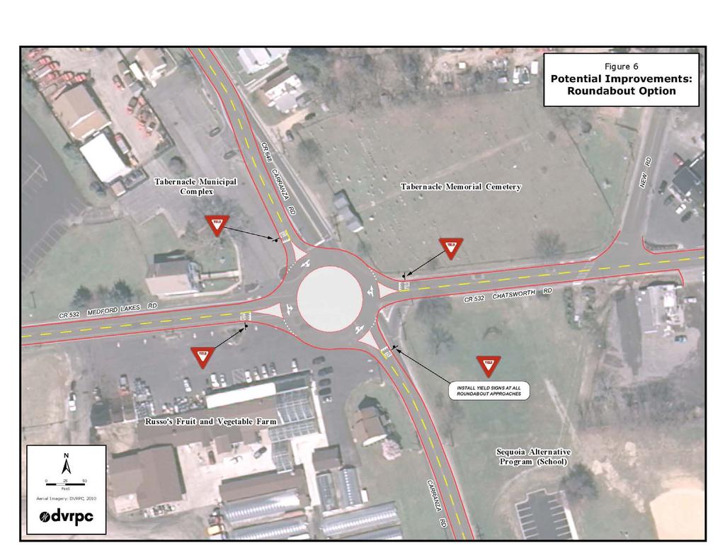
23 Table 5: LOS Analysis Scenario 1 Direction Delay (s) Existing Condition Scenario 1 AM PM AM PM LOS Delay (s) LOS Delay (s) LOS Delay (s) Northbound CR B 8 A 12 B 9 A Southbound CR B 12 B 11 B 10 B Eastbound CR B 12 B 17 C 13 B Westbound CR C 14 B 12 B 11 B Total Intersection 14 B 12 B 13 B 11 B Source: DVRPC, 2011 LOS Scenario #2 Construct a Roundabout Characteristic Construct a single-lane roundabout. Advantages Roundabouts reduce the chance and severity of crashes. Roundabouts force slower vehicle speeds. Roundabouts are more environmentally friendly (reduce pollution). Roundabouts are cheaper to maintain than a traffic signal. Drivers traveling through a roundabout experience less delay. Disadvantages Given the skew layout of the intersection, there are limited options of where to place the roundabout. In order accommodate a roundabout at this location; ROW would need to be acquired from the Tabernacle Municipal Complex and Russo s Fruit and Vegetable Farm. See Figure 6. Officials from Tabernacle Township do not support the construction of a roundabout at the study intersection. Conclusions from Scenarios The intersection of CR 648 and CR 532 currently operates at desirable levels. Both of the scenarios considered provide some benefit in improving the traffic and making the intersection safer. Scenario 2 would likely have the greatest impact and a significant cost; however, without the support from the municipality, this option is not worth considering. 17

24 Figure 5: Potential Improvements Figure 6: Potential Improvements Roundabout 18 Burlington County CCSAP
25 Option 19
26
27 C H A P T E R 6 Recommendations At the follow-up meeting held on June 23, 2011, representatives from the Burlington County Engineering Department, Tabernacle Township, and DVRPC worked together and developed a set of recommendations. The agreed-upon recommendations should provide safety and operational benefits for the intersection of CR 648 and CR 532. The short-term recommendations are listed in Table 6. The highlighted text in the table reflects the recommended improvements that the Burlington County Engineering Department has implemented. Table 6: Short-term Recommended Improvements Issues 1. Motorists fail to stop at the intersection. 2. The stop bar on the southbound CR 648 approach is located too far back from the intersection. 3. The southbound CR 648 approach is wide enough for two separate turn lanes; however, it is currently striped as a single lane for all traffic movements. 4. The passing zone on CR 648 is located too close to the intersection (located approximately 150 feet north of the stop bar from intersection). Source: DVRPC, 2011 Recommended Improvements 1. Install advance stop ahead warning signs. 2. Move the stop bar on the southbound CR 648 approach closer to the intersection. The county has implemented this improvement. 3. Restripe the lane configuration for one exclusive right-turn lane and one shared through and left-turn lane. The county has implemented this improvement. 4. Add double lines to indicate no passing zone. The county has implemented this improvement. Two long-term improvements were identified. The first long-term improvement is contingent upon the second recommendation being implemented. The long-term recommendations are listed in Table 7. Table 7: Long-term Recommended Improvements Issues 1. The stop bar on the westbound CR 532 approach is located too far back from the intersection. 2. There are heavy westbound right-turning movements during the morning peak period. Source: DVRPC, 2011 Recommended Improvements 1. The county will consider relocating the stop bar after determining whether to proceed with adding a right-turn lane. 2. The county will consider adding a dedicated right-turn lane at the westbound approach. 21
28

29 APPENDIX A
30
31 Study Advisory Committee Members Table A-1: Study Advisory Committee Members Name Organization Title Kim Brown Tabernacle Township Mayor Doug Cramer Tabernacle Township Administrator Marty Livingston Burlington County Engineering Department Traffic Engineer Jesse Buerk DVRPC Transportation Planner Regina Moore DVRPC Transportation Engineer Source: DVRPC, 2011 A 1
32
33 Publication Title: Congestion and Crash Site Analysis Program Tabernacle Township, Burlington County Publication Number: Date Published: October 2011 Geographic Area Covered: Key Words: Abstract: Tabernacle Township, Burlington County Carranza Road, Medford Lakes Road, CR 532, CR 648, high risk rural road, HRRR, level of service, LOS, intersection, safety, crashes, roadway, improvements, turning movements, peak hour, strategies This document represents the findings and recommendations for the Congestion and Crash Site Analysis Program study conducted in Burlington County in Fiscal Year This Program represents an effort to improve the mobility and safety on roadways in the DVRPC region. The goal of the program is to identify cost-effective improvement strategies that will reduce congestion and crashes and improve mobility and safety for all road users. Working with a data-driven process and the Burlington County Engineering Department, the intersection of CR 648 (Carranza Road) and CR 532 (Medford Lakes Road/Chatsworth Road) was chosen for analysis. In-depth crash and level of service analyses were performed to quantify and gain an understanding of the issues. With input from the advisory committee, improvement strategies were identified to address the issues. As appropriate, proposed improvement strategies were tested for level of effectiveness and recommended for improving safety at the intersection. Some of the recommendations were immediately implemented by the county. Staff Contact: Regina Moore Transportation Engineer (215) rmoore@dvrpc.org Delaware Valley Regional Planning Commission 190 N. Independence Mall West, 8th Floor Philadelphia PA Phone: (215) Fax: (215) Internet:
34
Burlington County Bicycle Level of Service Study
 Burlington County Bicycle Level of Service Study June 2013 The Delaware Valley Regional Planning Commission is dedicated to uniting the region s elected officials, planning professionals, and the public
State Street Transit Signal Priority Study
 State Street Transit Signal Priority Study April 2015 The Delaware Valley Regional Planning Commission is dedicated to uniting the region s elected officials, planning professionals, and the public with
TRAFFIC IMPACT ANALYSIS
 TRAFFIC IMPACT ANALYSIS FOR THE CHAMPAIGN UNIT#4 SCHOOL DISTRICT PROPOSED HIGH SCHOOL (SPALDING PARK SITE) IN THE CITY OF CHAMPAIGN Final Report Champaign Urbana Urbanized Area Transportation Study 6/24/2014
Existing Conditions. Date: April 16 th, Dan Holderness; Coralville City Engineer Scott Larson; Coralville Assistant City Engineer
 Date: April 16 th, 2015 To: From: Re: Dan Holderness; Coralville City Engineer Scott Larson; Coralville Assistant City Engineer Darian Nagle-Gamm, Traffic Engineering Planner Highway 6 (2 nd Street) /
Evaluation of M-99 (Broad Street) Road Diet and Intersection Operational Investigation
 Road Diet and Intersection Operational Investigation") Evaluation of M-99 (Broad Street) Road Diet and Intersection Operational Investigation City of Hillsdale, Hillsdale County, Michigan June 16, 2016 Final Report Prepared for City of Hillsdale 97 North Broad
Evaluation of M-99 (Broad Street) Road Diet and Intersection Operational Investigation City of Hillsdale, Hillsdale County, Michigan June 16, 2016 Final Report Prepared for City of Hillsdale 97 North Broad
DEPARTMENT OF ENVIRONMENTAL SERVICES. North Harrison Street (Lee Highway to Little Falls Road) Comparative Analysis. Prepared for:
 Comparative Analysis. Prepared for:") DEPARTMENT OF ENVIRONMENTAL SERVICES North Harrison Street (Lee Highway to Little Falls Road) Comparative Analysis Prepared for: Arlington County Department of Environmental Services 2100 Clarendon Boulevard,
DEPARTMENT OF ENVIRONMENTAL SERVICES North Harrison Street (Lee Highway to Little Falls Road) Comparative Analysis Prepared for: Arlington County Department of Environmental Services 2100 Clarendon Boulevard,
TRANSPORTATION ANALYSIS REPORT US Route 6 Huron, Erie County, Ohio
 TRANSPORTATION ANALYSIS REPORT US Route 6 Huron, Erie County, Ohio December 12, 2012 Prepared for: The City of Huron 417 Main Huron, OH 44839 Providing Practical Experience Technical Excellence and Client
BICYCLE FACILITIES INVENTORY: SUMMARY REPORT
 BICYCLE FACILITIES INVENTORY: SUMMARY REPORT Southern New Jersey September 2008 2002 D Lincoln Drive West Marlton, NJ 08053 (856) 596-8228 www.driveless.com BICYCLE FACILITIES INVENTORY SUMMARY REPORT
Chapter 4 Traffic Analysis
 Chapter 4 Traffic Analysis PURPOSE The traffic analysis component of the K-68 Corridor Management Plan incorporates information on the existing transportation network, such as traffic volumes and intersection
Project Report. South Kirkwood Road Traffic Study. Meadows Place, TX October 9, 2015
 Meadows Place, TX October 9, 2015 Contents 1 Introduction... 1 2 Data Collection... 1 3 Existing Roadway Network... 2 4 Traffic Volume Development... 2 5 Warrant Analysis... 3 6 Traffic Control Alternative
133 rd Street and 132 nd /Hemlock Street 132 nd Street and Foster Street MINI ROUNDABOUTS. Overland Park, Kansas
 133 rd Street and 132 nd /Hemlock Street 132 nd Street and Foster Street MINI ROUNDABOUTS Overland Park, Kansas September 1, 2017 TABLE OF CONTENTS 1. INTRODUCTION... 1 2. LITERATURE REVIEW... 1 3. CONCEPT
Introduction
 The Delaware Valley Regional Planning Commission is dedicated to uniting the region s elected officials, planning professionals and the public with a common vision of making a great region even greater.
Highway 111 Corridor Study
 Highway 111 Corridor Study June, 2009 LINCOLN CO. HWY 111 CORRIDOR STUDY Draft Study Tea, South Dakota Prepared for City of Tea Sioux Falls Metropolitan Planning Organization Prepared by HDR Engineering,
TRAFFIC IMPACT STUDY And A TRAFFIC SIGNAL WARRANT ANALYSIS FOR A SENIOR LIVING AND APARTMENT DEVELOPMENT
 TRAFFIC IMPACT STUDY And A TRAFFIC SIGNAL WARRANT ANALYSIS FOR A SENIOR LIVING AND APARTMENT DEVELOPMENT DEERFIELD TOWNSHIP, WARREN COUNTY, OHIO Nantucket Circle and Montgomery Road () Prepared for: ODLE
i TABLE OF CONTENTS Executive Summary 01 Chapter 1 Introduction 03 Chapter 2 Roadway and Traffic Characteristics 04 Chapter 3 Traffic Safety 09
 Created in 1965, the Delaware Valley Regional Planning Commission (DVRPC) is an interstate, intercounty and intercity agency that provides continuing, comprehensive and coordinated planning to shape a
Public Information Centre
 WELCOME Public Information Centre Father Tobin Road Lougheed Middle School - Library Wednesday November 7, 2012 7:00 p.m.to 9:00 p.m. Please sign in Neighbourhood Traffic Calming Guide Background The City
Traffic Impact Study. Westlake Elementary School Westlake, Ohio. TMS Engineers, Inc. June 5, 2017
 TMS Engineers, Inc. Traffic Impact Study Westlake Elementary School Westlake, Ohio June 5, 2017 Prepared for: Westlake City Schools - Board of Education 27200 Hilliard Boulevard Westlake, OH 44145 TRAFFIC
5858 N COLLEGE, LLC N College Avenue Traffic Impact Study
 5858 N COLLEGE, LLC nue Traffic Impact Study August 22, 2016 Contents Traffic Impact Study Page Preparer Qualifications... 1 Introduction... 2 Existing Roadway Conditions... 5 Existing Traffic Conditions...
DIMARCO CANANDAIGUA PROPERTIES HOUSING PROJECT CANANDAIGUA, ONTARIO COUNTY, NEW YORK
 TRAFFIC IMPACT STUDY FOR THE DIMARCO CANANDAIGUA PROPERTIES HOUSING PROJECT CANANDAIGUA, ONTARIO COUNTY, NEW YORK MARCH 14, 2017 PREPARED FOR: 1950 Brighton Henrietta Town Line Rd Rochester, NY 14623 PREPARED
Princeton Avenue and Spruce Street Transportation and Site Access Enhancements Project
 Princeton Avenue and Spruce Street Transportation and Site Access Enhancements Project Mercer County Planning Division AECOM Transportation (formerly DMJM Harris) January 29, 2009 Agenda Project Status
RSTF Measurements and Status
 RSTF Measurements and Status Items in green text are on or ahead of target. Items in red text need attention. Objective & Measures Status November, 2011 Winter, 3/8/12 Build, Maintain, & Leverage Partnerships
Transportation Impact Study for Abington Terrace
 Transportation Impact Study for Abington Terrace Abington Township, Montgomery County, PA Sandy A. Koza, P.E., PTOE PA PE License Number PE059911 Prepared by McMahon Associates, Inc. 425 Commerce Drive,
Summary: Mercer County Princeton Avenue & Spruce Street Study January 2009
 Summary: Several recent studies have assessed potential development and redevelopment opportunities in the Mercer Crossing area of Trenton, Ewing, and Lawrence. This Princeton Avenue and Spruce Street
Small Area Study U.S. Route 220 and VA Route 615 Intersection. Bath County, Virginia
 Small Area Study U.S. Route 220 and VA Route 615 Intersection Bath County, Virginia Prepared by the Central Shenandoah Planning District Commission Final Report February 2018 Table of Contents 1. INTRODUCTION...
ALLEY 24 TRAFFIC STUDY
 ALLEY 24 TRAFFIC STUDY in City of Frostburg, Maryland January 2013 3566 Teays Valley Road Hurricane, WV Office: (304) 397-5508 www.denniscorporation.com Alley 24 Traffic Study January 2013 Frostburg, Maryland
THIS PAGE LEFT BLANK INTENTIONALLY
 GA SR 25 Spur at Canal Road Transportation Impact Analysis PREPARED FOR GLYNN COUNTY, GEORGIA 1725 Reynolds Street, Suite 300 Brunswick, Georgia 31520 PREPARED BY 217 Arrowhead Boulevard Suite 26 Jonesboro,
Highway 49, Highway 351 and Highway 91 Improvements Feasibility Study Craighead County
 Highway 49, Highway 351 and Highway 91 Improvements Feasibility Study Craighead County Executive Summary March 2015 Highway 49, Highway 351 and Highway 91 Improvements Feasibility Study Craighead County
Military Road Safety Improvements
 Military Road Safety Improvements 26 th Road North to 31 st Street North SUMMARY OF DATA REVIEW AND PRELIMINARY RECOMMENDATIONS Prepared for: Department of Environmental Services Traffic Engineering and
MEMORANDUM. DATE March 1, 2012 TO Town of Milton Mark Abbott, Seth Asante, and Efi Pagitsas Boston Region MPO Staff
 MEMORANDUM DATE March 1, 212 TO Town of Milton FROM RE Mark Abbott, Seth Asante, and Efi Pagitsas Boston Region MPO Staff FFY 211 Safety and Operations Analyses at Selected Boston Region MPO Intersections:
Traffic Circulation Study for Neighborhood Southwest of Mockingbird Lane and Airline Road, Highland Park, Texas
 ARIZONA TEXAS NEW MEXICO OKLAHOMA February 13, 2015 Mr. Meran Dadgostar P.E., R.S. Town of Highland Park 4700 Drexel Dr. Highland Park, Texas 75205 Re: Traffic Circulation Study for Neighborhood Southwest
STILLWATER AVENUE CORRIDOR STUDY Old Town, Maine
 Draft Study STILLWATER AVENUE CORRIDOR STUDY Old Town, Maine SUBMITTED TO: BANGOR AREA COMPREHENSIVE TRANSPORTATION SYSTEM SUBMITTED BY: I MAY 23, 2017 DRAFT STILLWATER AVENUE STUDY FINAL REPORT Table
Route 28 (South Orleans Road)/Route 39 (Harwich Road)/Quanset Road Intersection
/Route 39 (Harwich Road)/Quanset Road Intersection") TRAFFIC FEASIBILITY STUDY Route 28 (South Orleans Road)/Route 39 (Harwich Road)/Quanset Road Intersection Orleans, Massachusetts Prepared for: Town of Orleans Prepared by: Fay, Spofford & Thorndike, LLC
TRAFFIC FEASIBILITY STUDY Route 28 (South Orleans Road)/Route 39 (Harwich Road)/Quanset Road Intersection Orleans, Massachusetts Prepared for: Town of Orleans Prepared by: Fay, Spofford & Thorndike, LLC
TRAFFIC ASSESSMENT River Edge Colorado
 TRAFFIC ASSESSMENT River Edge Colorado Submitted by: Fehr & Peers 621 17th Street, Ste. 231 Denver, CO 8293 (33) 296-43 December, 21 App. M-2 Traffic Assessment River Edge Colorado December 21 TABLE OF
Traffic Impact Analysis Chatham County Grocery Chatham County, NC
 Chatham County Grocery Chatham County, NC TABLE OF CONTENTS 1. INTRODUCTION... 1 1.1. Location and Study Area... 1 1.2. Proposed Land Use and Access... 2 1.3. Adjacent Land Uses... 2 1.4. Existing ways...
WELCOME Public Information Centre
 WELCOME Public Information Centre Fernforest Drive Brampton Soccer Centre Community Room #2 Tuesday January 19, 2016 6:30 p.m.to 9:00 p.m. Please sign in Neighbourhood Traffic Calming Guide Background
Troutbeck Farm Development
 Troutbeck Farm Development Willistown Township, Chester County PA For Submission To: Willistown Township Last Revised: October, 4 TPD# INLM.A. 5 E. High Street Suite 65 Pottstown, PA 9464 6.36.3 TPD@TrafficPD.com
DRAFT. Corridor study. Honeysuckle Road. October Prepared for the City of Dothan, AL. Prepared by Gresham, Smith and Partners
 DRAFT Corridor study Honeysuckle Road October 2017 Prepared for the City of Dothan, AL Prepared by TABLE OF CONTENTS SECTION I... 1 STUDY SUMMARY... 1 INTRODUCTION... 1 CONCLUSIONS... 5 SECTION II... 7
CAPE COD COMMISSION 3225 MAIN STREET P.O. BOX 226 BARNSTABLE, MA (508) Fax (508) Transportation Safety Report
 Fax (508) Transportation Safety Report") CAPE COD COMMISSION 3225 MAIN STREET P.O. BOX 226 BARNSTABLE, MA 02630 (508) 362-3828 Fax (508) 362-3136 2006 Transportation Safety Report Bourne: Otis Rotary Harwich: Route 137/Route 39 Orleans: Route
CAPE COD COMMISSION 3225 MAIN STREET P.O. BOX 226 BARNSTABLE, MA 02630 (508) 362-3828 Fax (508) 362-3136 2006 Transportation Safety Report Bourne: Otis Rotary Harwich: Route 137/Route 39 Orleans: Route
North Shore Transportation Improvement Strategy
 North Shore Transportation Improvement Strategy Preliminary, Near-term Recommendation 2016 April Transportation Improvement Strategy (TIS) Comprehensive and Analytical A multi-modal transportation strategy
Simulation Analysis of Intersection Treatments for Cycle Tracks
 Abstract Simulation Analysis of Intersection Treatments for Cycle Tracks The increased use of cycle tracks also known as protected bike lanes has led to investigations of how to accommodate them at intersections.
Traffic Study of Fuller Street, Cady Street, West Street and West Avenue. Final Report
 Traffic Study of Fuller Street, Cady Street, West Street and West Avenue Final Report July 2005 Prepared for: Town of Ludlow Prepared by: Pioneer Valley Planning Commission 26 Central Street West Springfield,
TRAFFIC IMPACT STUDY
 TRAFFIC IMPACT STUDY for the GLEN ELLEN COUNTRY CLUB SENIOR RESIDENTIAL REDEVELOPMENT 84 Millis, Massachusetts Prepared by: McMahon Associates, Inc. Prepared for: Toll Brothers, Inc. August 216 DRAFT
J Street and Folsom Boulevard Lane Conversion Project (T ) Before and After Traffic Evaluation
 Before and After Traffic Evaluation") J Street and Folsom Boulevard Lane Conversion Project (T15125400) Before and After Traffic Evaluation Prepared by Transportation Division June 2014 Executive Summary On February 12, 2013, the City of Sacramento
J Street and Folsom Boulevard Lane Conversion Project (T15125400) Before and After Traffic Evaluation Prepared by Transportation Division June 2014 Executive Summary On February 12, 2013, the City of Sacramento
Date: April 4, Project #: Re: A Street/Binford Street Traffic/Intersection Assessment
 To: Peter Cavanaugh General Electric From: David Bohn, PE Ryan White, PE Date: April 4, 217 Project #: 13421. Re: / Traffic/Intersection Assessment Consistent with the Cooperation Agreement between the
Taming Traffic: Bethlehem Pike Phase II - Road Diet Evaluation
 Taming Traffic: Bethlehem Pike Phase II - Road Diet Evaluation March 2012 i Taming Traffic: Bethlehem Pike Phase II - Road Diet Evaluation March 2012 i The Delaware Valley Regional Planning Commission
Date: 09/22/2016 Subject: To: From: PennDOT Engineering District 5-0. Dear Applicant,
 Date: 09/22/2016 Subject: Highway Occupancy Permit Application No. 112807 Returned For Revisions To: Wal-Mart Real Estate Business Trust 2001 SE 10th Street Bentonville, AR 72716 From: PennDOT Engineering
Dr. M.L. King, Jr. Street North Complete Streets Resurfacing Opportunities HOUSING, LAND USE, AND TRANSPORTATION COMMITTEE MARCH 22, 2018
 Dr. M.L. King, Jr. Street North Complete Streets Resurfacing Opportunities HOUSING, LAND USE, AND TRANSPORTATION COMMITTEE MARCH 22, 2018 What s Happening The City plans to mill and resurface Dr. M.L.
ENHANCED PARKWAY STUDY: PHASE 2 CONTINUOUS FLOW INTERSECTIONS. Final Report
 Preparedby: ENHANCED PARKWAY STUDY: PHASE 2 CONTINUOUS FLOW INTERSECTIONS Final Report Prepared for Maricopa County Department of Transportation Prepared by TABLE OF CONTENTS Page EXECUTIVE SUMMARY ES-1
CITY OF OAKLAND. 27th Street Bikeway Feasibility and Design. Final Report (v3) March 23, Kimley-Horn and Associates, Inc.
 March 23, Kimley-Horn and Associates, Inc.") CITY OF OAKLAND 27th Street Bikeway Feasibility and Design Final Report (v3) March 23, 2007 PREPARED BY: Kimley-Horn and Associates, Inc. Table of Contents 1. Introduction 3 2. 27 th Street/Bay Place Corridor
CITY OF OAKLAND 27th Street Bikeway Feasibility and Design Final Report (v3) March 23, 2007 PREPARED BY: Kimley-Horn and Associates, Inc. Table of Contents 1. Introduction 3 2. 27 th Street/Bay Place Corridor
Walmart (Store # ) 60 th Street North and Marion Road Sioux Falls, South Dakota
 60 th Street North and Marion Road Sioux Falls, South Dakota") Walmart (Store #4865-00) 60 th Street North and Marion Road Sioux Falls, South Dakota Prepared for: Wal-Mart Stores, Inc. Bentonville, Arkansas Prepared by: Kimley-Horn and Associates, Inc. ã2013 Kimley-Horn
Walmart (Store #4865-00) 60 th Street North and Marion Road Sioux Falls, South Dakota Prepared for: Wal-Mart Stores, Inc. Bentonville, Arkansas Prepared by: Kimley-Horn and Associates, Inc. ã2013 Kimley-Horn
Table of Contents FIGURES TABLES APPENDICES. Traffic Impact Study Hudson Street Parking Garage MC Project No.: A Table of Contents
 Traffic Impact Study Hudson Street Parking Garage MC Project No.: 151714A Table of Contents Table of Contents I. INTRODUCTION... 2 II. EXISTING CONDITIONS... 5 III. 215 EXISTING TRAFFIC CONDITIONS... 6
Traffic Circulation & Pedestrian Safety Study
 Lyons Township High School North Campus La Grange, Illinois Parking Lot Vaughan Building N Main Building Prepared for: Prepared by: July 23, 2015 Contents List of Figures, iii 1. Introduction...1 2. Existing
Balancing Operation & Safety for Motorized and Non-Motorized Traffic
 Balancing Operation & Safety for Motorized and Non-Motorized Traffic Brian Willham, PE, PTOE Iowa Director - MOVITE June 30, 2014 Learning Objectives: When & Why should we measure the performance of complete
4. ENVIRONMENTAL IMPACT ANALYSIS 9. TRANSPORTATION AND TRAFFIC
 4. ENVIRONMENTAL IMPACT ANALYSIS 9. TRANSPORTATION AND TRAFFIC 4.9.1 INTRODUCTION The following section addresses the Proposed Project s impact on transportation and traffic based on the Traffic Study
8 PROPOSED ROUNDABOUT DUFFERIN STREET AND KING VAUGHAN ROAD INTERSECTION CITY OF VAUGHAN
 8 PROPOSED ROUNDABOUT DUFFERIN STREET AND KING VAUGHAN ROAD INTERSECTION CITY OF VAUGHAN The Transportation Services Committee recommends the adoption of the recommendation contained in the following report
Chapter 2: Standards for Access, Non-Motorized, and Transit
 Standards for Access, Non-Motorized, and Transit Chapter 2: Standards for Access, Non-Motorized, and Transit The Washtenaw County Access Management Plan was developed based on the analysis of existing
Traffic Impact Study WestBranch Residential Development Davidson, NC March 2016
 Traffic Impact Study WestBranch Residential Development Davidson, NC March 216 TRAFFIC IMPACT STUDY FOR THE WestBranch Residential Development LOCATED IN DAVIDSON, NC Prepared For: Lennar Carolinas, LLC
Access Management Regulations and Standards
 Access Management Regulations and Standards Efficient highway operation Reasonable property access Concept of Access Management The way to manage access to land development while simultaneously preserving
Truck Climbing Lane Traffic Justification Report
 ROUTE 7 (HARRY BYRD HIGHWAY) WESTBOUND FROM WEST MARKET STREET TO ROUTE 9 (CHARLES TOWN PIKE) Truck Climbing Lane Traffic Justification Report Project No. 6007-053-133, P 101 Ι UPC No. 58599 Prepared by:
appendix b BLOS: Bicycle Level of Service B.1 Background B.2 Bicycle Level of Service Model Winston-Salem Urban Area
 appendix b BLOS: B.1 Background Winston-Salem Urban Area Bicycle Level of Service Level of Service (LOS) is a framework that transportation professionals use to describe existing conditions (or suitability)
CITY OF WEST LAKE HILLS. Forest View Neighborhood Traffic Calming Study
 CITY OF WEST LAKE HILLS 901 South Mopac Expressway Building V, Suite 220 Austin, Texas 78746 Texas P.E. Firm Registration No. F-929 Klotz Associates Final Report Submittal: March 20, 2015 Revised Final
Access Management in the Vicinity of Intersections
 Access Management in the Vicinity of Intersections FHWA-SA-10-002 Technical Summary Photo: Ralph Bentley (used with permission) 0 Access Management is: The design, implementation and management of entry
Executive Summary June 2015
 Executive Summary June 2015 Highway 112 Corridor Study Benton and Washington Counties Executive Summary June 2015 Prepared by Transportation Planning and Policy Division Arkansas State Highway and Transportation
M-58 HIGHWAY ACCESS MANAGEMENT STUDY Mullen Road to Bel-Ray Boulevard. Prepared for CITY OF BELTON. May 2016
 M-58 HIGHWAY ACCESS MANAGEMENT STUDY Prepared for CITY OF BELTON By May 2016 Introduction Missouri State Highway 58 (M-58 Highway) is a major commercial corridor in the City of Belton. As development has
BLOSSOM AT PICKENS SIGNALIZED INTERSECTION IMPROVEMENT STUDY
 BLOSSOM AT PICKENS SIGNALIZED INTERSECTION IMPROVEMENT STUDY Class Project Report for ECIV 542 Traffic Engineering Submitted by Omor Sharif Muchun Song Narges Kaveshgar Quyen Pham Chih-Yao Lin Submission
WEST AVENUE AND NEW ROAD TRAFFIC STUDY PART III WEST AVENUE CLOSURE ALTERNATIVES ANALYSIS
 WEST AVENUE AND NEW ROAD TRAFFIC STUDY PART III WEST AVENUE CLOSURE ALTERNATIVES ANALYSIS CITY OF LINWOOD ATLANTIC COUNTY, NEW JERSEY March 30, 2006 PREPARED FOR: City of Linwood 400 Poplar Avenue Linwood,
5.0 Roadway System Plan
 Southwest Boise Transportation Study Page 16 5.0 Roadway System Plan The Roadway System Plan outlines roadway improvements in the Initial Study Area. It forecasts future deficiencies on the arterial system,
DUNBOW ROAD FUNCTIONAL PLANNING
 DUNBOW ROAD FUNCTIONAL PLANNING Final Report August 3, 216 #31, 316 5th Avenue NE Calgary, AB T2A 6K4 Phone: 43.273.91 Fax: 43.273.344 wattconsultinggroup.com Dunbow Road Functional Planning Final Report
METHODOLOGY. Signalized Intersection Average Control Delay (sec/veh)
") Chapter 5 Traffic Analysis 5.1 SUMMARY US /West 6 th Street assumes a unique role in the Lawrence Douglas County transportation system. This principal arterial street currently conveys commuter traffic
Chapter 5 Traffic Analysis 5.1 SUMMARY US /West 6 th Street assumes a unique role in the Lawrence Douglas County transportation system. This principal arterial street currently conveys commuter traffic
Complete Street Analysis of a Road Diet: Orange Grove Boulevard, Pasadena, CA
 Complete Street Analysis of a Road Diet: Orange Grove Boulevard, Pasadena, CA Aaron Elias, Bill Cisco Abstract As part of evaluating the feasibility of a road diet on Orange Grove Boulevard in Pasadena,
Traffic Impact Analysis Walton Acres at Riverwood Athletic Club Clayton, NC
 Traffic Impact Analysis Walton Acres at Riverwood Athletic Club Clayton, NC 1. TABLE OF CONTENTS INTRODUCTION...1 1.1. Site Location and Study Area...1 1.2. Proposed Land Use and Site Access...2 1.3.
1609 E. FRANKLIN STREET HOTEL TRAFFIC IMPACT STUDY EXECUTIVE SUMMARY
 1609 E. FRANKLIN STREET HOTEL TRAFFIC IMPACT STUDY EXECUTIVE SUMMARY Prepared for: The Town of Chapel Hill Public Works Department Traffic Engineering Division Prepared by: HNTB North Carolina, PC 343
MUTCD Part 6G: Type of Temporary Traffic Control Zone Activities
 MUTCD Part 6G: Type of Temporary Traffic Control Zone Activities 6G.01 Typical Applications Each temporary traffic control (TTC) zone is different. Many variables, such as location of work, highway type,
STANLEY STREET December 19, 2017
 STANLEY STREET December 19, 2017 Welcome Mike Wiza, Mayor Scott Beduhn, Director of Public Works Agenda 1. Introduction 2. Existing Roadway Conditions 3. Current Alternative Improvements 4. Summary of
Capital Region Council of Governments
 March 23, 2018 Capital Region Council of Governments PROJECT CONCEPT REPORT Realignment of Swamp and Northfield Road s approaches to Route 44 (Boston Turnpike) Town of Coventry SUMMARY: The Town of Coventry
DOWNTOWN TUPELO MAIN STREET: ROAD DIET STUDY
 DOWNTOWN TUPELO MAIN STREET: ROAD DIET STUDY Since mid-2009, RPM Transportation Consultants (RPM) has worked with the Downtown Tupelo Main Street Association to evaluate traffic conditions and potential
Road Conversion Study Plumas Street
 Plumas Street Phase I Submitted to The Regional Transportation Commission of Washoe County Submitted by Zong Tian, Ph.D., P.E. Saeedeh Farivar Haiyuan Li, Ph.D. Center for Advanced Transportation Education
Parks Highway: MP Lucus Road to Big Lake Road
 2 Purpose and Need 2.1 Corridor History The Parks Highway is a 324-mile long Rural Interstate Highway that extends from its intersection with the Glenn Highway north to Fairbanks, Alaska. The Parks Highway
Low Level Road Improvements Traffic Analysis. Report
 Low Level Road Improvements Traffic Analysis Report June, 22 Table of Contents. INTRODUCTION.... LOW LEVEL ROAD PROJECT....2 STUDY AREA....2. West-End Corridor Improvements... 2.2.2 East-End Corridor Improvements...
INTERSECTION SAFETY STUDY State Route 57 / Seville Road
 INTERSECTION SAFETY STUDY State Route 57 / Seville Road City of Wadsworth, Medina County, Ohio Prepared For: City of Wadsworth Engineering Department 120 Maple Street Wadsworth, OH 44281 Prepared By: GPD
Chapter 16: Traffic and Parking A. INTRODUCTION
 Chapter 6: Traffic and Parking A. ITRODUCTIO This chapter examines the potential traffic and parking impacts of the proposed Fresh Kills Park roads. The analysis of transit and pedestrians is presented
Appendix B: Forecasting and Traffic Operations Analysis Framework Document
 Existing Conditions Report - Appendix Appendix B: Forecasting and Traffic Operations Analysis Framework Document This document defines the methodology and assumptions that will be used in the traffic forecasting
7 th Street Bike Lane Traffic Impact Study
 7 th Street Bike Lane Traffic Impact Study Submitted by: San Francisco Department of Parking and Traffic Michael Sallaberry June 11, 2001 EXECUTIVE SUMMARY This report presents the Department of Parking
Access Management Regulations and Standards
 Access Management Regulations and Standards January 2014 Efficient highway operation Reasonable property access Concept of Access Management The way to manage access to land development while preserving
Intersection Traffic Control Feasibility Study
 Intersection Traffic Control Feasibility Study CSAH 9 at CSAH 60 (185th Avenue) Prepared For: Dakota County Transportation Department Western Service Center 14955 Galaxie Avenue, 3rd Floor Apple Valley,
MEMORANDUM. Layout Of Study Intersections And Traffic Control
 BOSTON REGION METROPOLITAN PLANNING ORGANIZATION Richard A. Davey, MassDOT Secretary and CEO and MPO Chairman Karl H. Quackenbush, Executive Director, MPO Staff DATE November 15, 2012 TO FROM RE Town of
Recommended Roadway Plan Section 2 - Land Development and Roadway Access
 Recommended Roadway Plan Section 2 - Land Development and Roadway Access SECTION 2 Land Development and Roadway Access 2.1 Land Use and Access Management The Federal Highway Administration (FHWA) defines
3 TRAFFIC CONTROL SIGNAL TIMING AND SYNCHRONIZATION
 Report No. 8 of the Transportation Services Committee Regional Council Meeting of October 20, 2011 3 TRAFFIC CONTROL SIGNAL TIMING AND SYNCHRONIZATION The Transportation Services Committee recommends:
Toward Zero Deaths. Regional SHSP Road Show Meeting. Virginia Strategic Highway Safety Plan. presented by
 Toward Zero Deaths Regional SHSP Road Show Meeting presented by Virginia Strategic Highway Safety Plan December 1, 2016 1 Welcome & Introductions Purpose of the Meeting Objectives & Key Outcomes Agenda»
Road Safety Audit Course Participant Guidebook. August 22 & 23, Cleveland Avenue Columbus, Ohio
 Road Safety Audit Course Participant Guidebook August 22 & 23, 2017 Cleveland Avenue Columbus, Ohio 1 2 Table of Contents Executive Summary... 5 Cleveland Avenue City of Columbus... 6 Road Location Details...
Toolbox of Countermeasures and Their Potential Effectiveness to Make Intersections Safer
 8 Toolbox of Countermeasures and Their to Make Intersections Safer Introduction Studies included in the NCHRP 17-18 (3), Guidance for Implementation of the AASHTO Strategic Highway Safety Plan, as well
Clackamas County Comprehensive Plan
 ROADWAYS The County s road system permits the movement of goods and people between communities and regions, using any of a variety of modes of travel. Roads provide access to virtually all property. They
TRAFFIC IMPACT ANALYSIS OF PROPOSED CHESTNUT HILL COLLEGE MASTER PLAN DEVELOPMENT
 TRAFFIC IMPACT ANALYSIS OF PROPOSED CHESTNUT HILL COLLEGE MASTER PLAN DEVELOPMENT Prepared by Orth-Rodgers & Associates, Inc. December 14, 2009 Updated November 9, 2010 230 South Broad Street Philadelphia
INNOVATIVE INTERSECTION DESIGN
 INNOVATIVE INTERSECTION DESIGN J. Eddie Valtier, P.E. ELP TP&D Director Introduction Why Do We Need To Start Looking For Innovative Intersection Designs? Congestion is worsening and traffic volumes and
Closing Plenary Session
 TRAFFIC SAFETY CONFERENCE Closing Plenary Session June 9, 2017 Las Colinas, TX Order of Report Out June 9, 2017 Las Colinas, TX Distracted Driving Prioritized Countermeasures Countermeasure 4a Systemically
Lincoln Avenue Road Diet Trial
 Lincoln Avenue Road Diet Trial Data Collection Report June 1, 2015 Department of Transportation Table of Contents I. Introduction...... 3 II. Data Collection Methodology & Results...... 5 A. Traffic Volume
Edenbrook Hill Drive Traffic Calming Study
 WELCOME Public Information Centre Edenbrook Hill Drive Traffic Calming Study Fletchers Meadow Secondary School Wednesday January 20, 2016 6:30 p.m.to 9:00 p.m. Please sign in Neighbourhood Traffic Calming
CITY OF OTTAWA ROADWAY MODIFICATION APPROVAL UNDER DELEGATED AUTHORITY
 RMA-2015-ATM-038 CITY OF OTTAWA ROADWAY MODIFICATION APPROVAL UNDER DELEGATED AUTHORITY DATE: April 22, 2015 SUBJECT Approval of Roadway Modifications Recommended through an Area Traffic Management Study
Proposed Action, Purpose and Need Technical Memorandum
 Proposed Action, Purpose and Need Technical Memorandum MoPac (State Loop 1) Intersections, Austin District From North of Slaughter Lane to South of La Crosse Avenue CSJ: 3136-01-015 Travis County, Texas
PRELIMINARY DRAFT FIRST AMENDMENT TO VISION 2050: A REGIONAL LAND USE AND TRANSPORTATION PLAN FOR SOUTHEASTERN WISCONSIN
 PRELIMINARY DRAFT FIRST AMENDMENT TO VISION 2050: A REGIONAL LAND USE AND TRANSPORTATION PLAN FOR SOUTHEASTERN WISCONSIN ESTABLISHING TARGETS FOR FEDERAL PERFORMANCE MEASURES: HIGHWAY SAFETY SOUTHEASTERN