i TABLE OF CONTENTS Executive Summary 01 Chapter 1 Introduction 03 Chapter 2 Roadway and Traffic Characteristics 04 Chapter 3 Traffic Safety 09
|
|
|
- Ellen Caldwell
- 5 years ago
- Views:
Transcription

1
2
3 Created in 1965, the Delaware Valley Regional Planning Commission (DVRPC) is an interstate, intercounty and intercity agency that provides continuing, comprehensive and coordinated planning to shape a vision for the future growth of the Delaware Valley region. The region includes Bucks, Chester, Delaware, and Montgomery counties, as well as the City of Philadelphia, in Pennsylvania; and Burlington, Camden, Gloucester and Mercer counties in New Jersey. DVRPC provides technical assistance and services; conducts high priority studies that respond to the requests and demands of member state and local governments; fosters cooperation among various constituents to forge a consensus on diverse regional issues; determines and meets the needs of the private sector; and practices public outreach efforts to promote two-way communication and public awareness of regional issues and the Commission. Our logo is adapted from the official DVRPC seal, and is designed as a stylized image of the Delaware Valley. The outer ring symbolizes the region as a whole, while the diagonal bar signifies the Delaware River. The two adjoining crescents represent the Commonwealth of Pennsylvania and the State of New Jersey. DVRPC is funded by a variety of funding sources including federal grants from the U.S. Department of Transportation s Federal Highway Administration (FHWA) and Federal Transit Administration (FTA), the Pennsylvania and New Jersey departments of transportation, as well as by DVRPC s state and local member governments. The authors, however, are solely responsible for its findings and conclusions, which may not represent the official views or policies of the funding agencies.
4 Case Study Corridor: State Road, US 1 (Springfield and Marple Townships, Delaware County) i TABLE OF CONTENTS Executive Summary 01 Chapter 1 Introduction 03 Chapter 2 Roadway and Traffic Characteristics 04 Chapter 3 Traffic Safety 09 Chapter 4 Conceptual Plans 16 Chapter 5 Conclusions / Next Steps 32 Chapter 6 References 33 LIST OF FIGURES Figure 1 Location Map 02 Figure 2 Access Management with Respect to Roadway Classification 04 Figure 3 Traffic Volumes and Land Use 07 Figure 4 Traffic Accident Patterns 11 Figure 5 Effects of Speed Differential between Turning Vehicles and Through Traffic on Crash Potential 15 Figure 6 Traffic Signal Permit Plan Collins Drive \ Marple Shopping Center Drive and State Road US 1 19 Figure 7 Traffic Signal Permit Plan Meetinghouse Lane and State Road US 1 23 Figure 8 Traffic Signal Permit Plan Springfield Road and State Road US 1 27 Figure 9 Median Closure Typical Section 30 Figure 10 Conceptual Highway Access Management Plan Back Pocket
5 Case Study Corridor: State Road, US 1 (Springfield and Marple Townships, Delaware County) ii LIST OF TABLES Table 1 Accident Locations 09 Table 2 Accident Patterns 10 Table 3 Proposed Improvements State Road US 1 at Collins Drive \ Marple Shopping Center Drive 16 Table 4 Proposed Improvements State Road US 1 at Meetinghouse Lane 21 Table 5 Proposed Improvements State Road US 1 at Springfield Road 25 Table 6 Proposed Improvements State Road US 1 at Buttonwood Drive 29 Table 7 Preliminary Engineering & Construction Cost Estimate State Road US 1 Improvements 31
6 Case Study Corridor: State Road, US 1 (Springfield and Marple Townships, Delaware County) 1 EXECUTIVE SUMMARY This report provides an analysis for the improvement of safety and congestion along State Road US 1 between Collins Drive and Springfield Road. Access management principles are the basis of the analysis and the recommended improvements. The study effort supports PENNDOT s effort to implement model access management ordinances for state and local highways statewide. To that end, staff of the Delaware Valley Regional Planning Commission (DVRPC) used PENNDOT s Access Management Ordinances for Pennsylvania Municipalities Handbook as a core reference in this project. DVRPC s access management work program involved a steering committee comprised of regional and county transportation and community planners, and representatives from the City of Philadelphia s Streets Department, PENNDOT District 6-0 Traffic Engineering and Highway Permits units, and SEPTA Service Planning Department. Drawing from the long range plan, congestion management systems, and corridor studies, the steering committee helped DVRPC staff identify two corridors for case study evaluation: State Road US 1 (Collins Drive to Springfield Road), and John Fries Highway PA 663 (Krammes Road to PA 309). Each corridor illustrates an area at a different stage of development, and therefore, are good examples of access management implementation in diverse circumstances. This Technical Memorandum focuses on State Road US 1 between Collins Drive and Springfield Road (Figure 1). The study highway is a four through lane road with a frontage road serving fully developed commercial development abutting single family neighborhoods on both sides of the roadway. Improvements noted within this report focus on modification of existing facilities to improve safety (pedestrian and vehicular) and access \ traffic flow. DVRPC staff evaluated the corridor using PennDOT s model ordinances and related reference material. Proposed recommendations were prepared with municipal and PENNDOT staff participation and are noted using existing PENNDOT traffic signal permit plans and a conceptual corridor plan formulated from 2000 aerial photography. Details are provided within the text of this report, and cost estimates are provided to help foster implementation of the identified improvements. In summary, the conceptual plan recommends closure of the lone non-signalized median opening on State Road, improved signage and pavement markings at signalized intersections, and reestablishing coordinated traffic signalization to progress traffic through the corridor. The total project cost estimated for the identified improvements is $ 90,000.
7
8 Case Study Corridor: State Road, US 1 (Springfield and Marple Townships, Delaware County) 3 1 INTRODUCTION Access management is one of many strategies available to a municipality to improve the function of its roadways. The methods employed in access management seek to optimize and maintain the existing transportation system while preparing for its future growth. Access management can be a relatively low cost means of reducing congestion and increasing both the efficiency and safety of a roadway. It can be introduced on a case-by-case basis by retrofitting at individual parcels, or incrementally along growing corridors through the land development application process. When consistently implemented, access management can produce impressive results. National studies indicate that access management techniques can contribute to a 40 percent reduction in highway collisions and may increase vehicular mobility by 30 percent. The methodology behind DVRPC s work program emphasized the correct implementation of appropriate access management strategies in association with PENNDOT s Model Access Management Ordinances project to extend the serviceability and improve the traffic safety along state and local roads. DVRPC s methodology for access management planning draws from its regional Congestion Management Process (CMP) planning. The congestion management system aims to minimize congestion and enhance the mobility of both people and goods. Congestion management processes act as a connection between the region s Long Range Plan and the region s Transportation Improvement Program (TIP) to ensure that the appropriate regional transportation facilities are improved. An initial step of Congestion Management Process Planning was to define congested corridors and sub-corridors within the Delaware Valley. The plan then considered the characteristics of each sub-corridor and provided strategies for congestion mitigation at each location, including access management strategies. DVRPC s access management work program was created to support the effort of PENNDOT s Model Access Management Ordinance project. To do this, DVRPC s work program for this project focuses on case studies. As such, it was a logical step to use the Congestion Management Process Planning as a guiding philosophy for selecting case study areas. To help DVRPC narrow the candidate case study corridors, a steering committee was formed to contribute to the work and provide comments on the products. The steering committee was comprised of regional and county transportation and community planners, and representatives from the City of Philadelphia s Streets Department, PENNDOT District 6-0 Traffic Engineering and Highway Permits Units, and SEPTA Service Planning Department. The steering committee helped DVRPC staff identify the candidate case study corridors and municipal contacts. Additionally, the host steering committee member participated in working meetings with the local municipality. All steering committee and local municipal staff were provided the opportunity to review the draft report and its findings.
 and John Fries Highway - PA 663 (Krammes Road to PA 309).")


9 4 Case Study Corridor: State Road, US 1 (Springfield and Marple Townships, Delaware County) Two corridor studies were conducted during the FY 2006 work program year: State Road - US 1 (Collins Drive to Springfield Road) and John Fries Highway - PA 663 (Krammes Road to PA 309). Each corridor illustrates areas at different stages of development, and therefore are good examples of access management s application in diverse circumstances. This Technical Memorandum focuses on State Road US 1 between Collins Drive and Springfield Road. The study highway is a four through lane highway, with a frontage road, abutting fully developed commercial properties intermingled with mature developments of single family homes. Sidewalks are present the entire length of the project on both sides of the roadway. Therefore improvements noted within this report focus on modification of existing facilities to improve safety (pedestrian and vehicular) and access \ traffic flow. 2 ROADWAY and TRAFFIC CHARACTERISTICS Highway functional classification is a qualitative description for the balance between mobility and land access provided by a highway. The relevance of the aforementioned roadway classifications with respect to highway access management are graphically depicted in Figure 2. Figure 2 - Access Management with Respect to Roadway Classification
10 Case Study Corridor: State Road, US 1 (Springfield and Marple Townships, Delaware County) 5 The study corridor s roadways are classified as follows: State Road US 1 (S.R. 0001) is an Other Freeway and Expressway. Sproul Road PA 320 (S.R. 0320) is a Principal Arterial. Springfield Road (S.R. 2009) is a Principal Arterial. Collins Drive (Township Road) is a Local Road. Stratford Drive (Township Road) is a Local Road. Meetinghouse Lane (Township Road) is a Local Road. Buttonwood Drive (Township Road) is a Local Road. There are also a variety of commercial and residential driveways intersecting State Road US 1 in the study segment. State Road US 1 is a divided highway ( expressway ) with three lanes in both directions at the southern approach to the signalized Collins Drive \ Marple Shopping Center Driveway intersection. A diamond interchange with Sproul Road PA 320 starts at the aforementioned signalized intersection and ends at the signalized Meetinghouse Lane \ Meadowgreen Park Entrance intersection. The mainline, which goes under Sproul Road, through this area consists of two lanes in both directions and one to two lanes on the frontage roads. State Road US 1 between Meetinghouse Lane and the signalized Springfield Road intersection is two through lanes southbound and three lanes northbound converging to two lanes northbound and a right turn lane at Springfield Road. In this section, there is a median opening at \ for Buttonwood Drive. This is the only unsignalized median opening in the State Road US 1 case study segment. State Road US 1 on the northern approach to Springfield Road is two through lanes southbound and northbound. The posted speed for State Road US 1 within the study corridor varies from 45 MPH to 55 MPH. The Annual Average Daily Traffic (AADT) volume on State Road US 1 within the study corridor is 45,100 vehicles. North of Springfield Road, daily traffic levels approximate 34,400 vehicles (see Figure 3). Daily traffic levels on cross streets or nearby highways in the study corridor are also shown on Figure 3. SEPTA operates two bus routes along in the study area: Route 110 from 69 th Street Terminal to Penn State via Springfield Mall and Media and Route 111 from 69 th Street Terminal to Chadds Ford. Both routes provide service along State road and utilize the frontage road serving numerous commercial and shopping developments. Five bus stops provide access points for passengers and are marked at the following locations: Westbound: Springfield Road (FS), Meetinghouse Lane (NS) Sproul Road/Strafford Circle (MB). Eastbound: Sproul Road (FS), Springfield Road (FS)
11 Case Study Corridor: State Road, US 1 (Springfield and Marple Townships, Delaware County) 6 The Marple Crossroads Shopping Center is directly serviced by Route 110, while Route 111 continues on the limited access highway linking Springfield and Middletown Townships. As part of SEPTA s Fiscal Year 2007 Annual Service Plan, Route 107 now provides north/south transit service along PA Route 320 between Lawrence Park Shopping Center and Springfield Mall. Transfer opportunities are possible between Routes 107, 110 and 111 at State and Sproul Roads. Route 107 service was implemented on August 28, Land use within the corridor is also illustrated on Figure 3. North \ west of the study highway segment, commercial development dominates from the Marple Crossroads Shopping Center to Meetinghouse Lane, and a residential neighborhood (single family detached) occupies the land from Meetinghouse Lane to Springfield Road, on the north \ east. On the south \ west portion of the corridor, a neighborhood of single family detached homes (served by Collins Drive) lies adjacent to commercial development. A shopping center also occupies the south \ east quadrant, extending to Meadowgreen Park Entrance, with a residential neighborhood between it and Springfield Road.

12
13
14 Case Study Corridor: State Road, US 1 (Springfield and Marple Townships, Delaware County) 9 3 TRAFFIC SAFETY Access management aims to improve both the efficiency and safety of a given roadway or corridor. Increased safety is addressed through access management by eliminating turning movements, reducing through travel interruptions, and making vehicle entrances and exits to / from driveways and roadways as controlled as possible. To assess the current traffic safety conditions along State Road US 1, traffic accident information was obtained from PENNDOT (1997 through 2003, excluding 2002 which was not available from PENNDOT). PENNDOT crash data is available through a database of reportable accidents 1 occurring on state highways in the commonwealth. Organizing traffic accidents by location and type is a logical way of assessing traffic safety conditions in the corridor. In turn, number of accidents, general accident patterns and causation factors have been summarized and categorized. With general knowledge as to the contributing factors to the incidents, a focused group of possible access management related countermeasures were derived. Locations: The four intersections with median openings within the State Road US 1 study corridor where accident analysis was performed were: # Cross Street Location Signalized? 1 Collins Drive \ Marple Shopping Center Y 2 Meetinghouse Lane \ Meadowgreen Park Y 3 Buttonwood Drive N 4 Springfield Road Y Table 1 summarizes the traffic accident conditions at the four (4) intersections. TABLE 1 ACCIDENT LOCATIONS Accidents Injuries Fatalities Location ( , EXCL. 2002) % of ( , EXCL. 2002) ( , EXCL. 2002) # Total # # Collins Drive % 93 0 Meetinghouse Lane % 33 0 Buttonwood Drive % 9 0 Springfield Road % TOTAL % Source: PENNDOT (1997 through 2003, excluding 2002) 1 Reportable accidents in Pennsylvania are defined to be those resulting in injury or death and/or requiring a tow-away. These are the only accidents that are reported to PENNDOT and kept on file in their database.
15 10 Case Study Corridor: State Road, US 1 (Springfield and Marple Townships, Delaware County) Ninety six (96) percent of the accidents occurred at the signalized intersections. Most accidents (45.2 %) occurred at the Springfield Road intersection followed closely by the Collins Drive \ Marple Shopping Center intersection (37.3 %). Buttonwood Drive accounted for ten accidents or 4.4 percent of the total. Patterns: The pie charts in Figure 4 provide a comparison of the types of accidents that occurred at each analyzed location. The size of the pie chart is reflective of the number of accidents occurring at the intersection. As shown, the highest number of accidents occur at the Springfield Road intersection, followed by Collins Drive, Meetinghouse Lane and Buttonwood Drive. All locations (with the exception of Buttonwood Drive) show a majority of angle accidents (yellow) and a substantial number of rear-end accidents (blue). The remaining composition varies between sites. Table 2 corresponds to the pie charts in Figure 4 and enumerates the type of each accident. TABLE 2 ACCIDENT PATTERNS Collins Drive Meetinghouse Lane Buttonwood Drive Springfield Road TOTAL Accident Type % OF % OF % OF % OF % OF # Total # Total # Total # Total # Total Non - Collison 0 0.0% 0 0.0% 0 0.0% 0 0.0% 0 0.0% Rear - End % % % % % Head On 0 0.0% 0 0.0% % 2 1.9% 3 1.3% Angle % % % % % Sideswipe 4 5% 4 13% 1 10% 2 2% 11 5% Hit Fixed Object 5 6% 1 3% 0 0% 5 5% 11 5% Other 3 4% 1 3% 1 10% 0 0% 5 2% TOTAL % % % % 228 Source: PENNDOT (1997 through 2003, excluding 2002) 100.0%

16
17
18 Case Study Corridor: State Road, US 1 (Springfield and Marple Townships, Delaware County) 13 A description of the nature of each major pattern at each intersection is provided and where appropriate, general countermeasures to remediate the accident type are identified. This section is intended to provide a preliminary understanding of access management and traffic safety improvement techniques that can be implemented. Contributing Factors: For each location factors contributing to traffic accidents were judged based upon field views of the intersections. Accidents at Collins Drive and State Road US 1 Contributing factors leading to the preponderance of angle accidents were based upon field views and include: 1) US 1 SB traffic turning right across the US 1 SB Frontage Road into Marple Shopping Center. 2) the right turn yield movement from the Marple Shopping Center to US 1 SB, merging without clearance interval, exacerbated by the speed differential of the turning and through movements. 3) left turns cheating on the signal s clearance interval. Field observation indicates rear-end accident patterns maybe due to: 1) confusion regarding lane control and turning movements. 2) excessive travel speeds (especially US 1 SB on the downgrade). 3) the right turn yield movement from the Marple Shopping Center to US 1 SB (speed differential). 4) lack of demarcation of hazards (i.e. sudden stops due to end islands not being marked). Accidents at Meetinghouse Lane and State Road US 1 Contributing factors for angle accidents include: 1) US 1 NB traffic turning right across the US 1 NB Frontage Road into Meadowgreen Park \ shopping center. 2) left turns cheating on the signal s clearance interval. Rear-end accident contributing factors include: 1) confusion regarding US 1 NB turning movements. 2) poor alignment of the Meadowgreen Park leg of the intersection.
19 14 Case Study Corridor: State Road, US 1 (Springfield and Marple Townships, Delaware County) Accidents at Buttonwood Drive and State Road US 1 Based upon field observations of the intersection factors contributing to angle accidents at the intersection are: 1) speed differential between turning movements and through traffic. 2) the lack of gaps on US 1 for turns to / from Buttonwood traffic. Rear-end accidents contributing factors include: 1) insufficient deceleration lane length in the two-way left turn lane. 2) confusion regarding turning movements onto Buttonwood Drive. Accidents at Springfield Road and State Road US 1 Contributing factors leading to the preponderance of angle accidents were based upon field views and include: 1) poor level of service 2) left turns cheating on the signal s clearance interval. Field observation indicates rear-end accident patterns maybe due to: 1) missing signage leading to confusion regarding turning movements. 2) lack of demarcation of hazards.

. The second tier addresses techniques for roadways (i.")
20 Case Study Corridor: State Road, US 1 (Springfield and Marple Townships, Delaware County) 15 Countermeasures: PennDOT s publication: Access Management Model Ordinances for Pennsylvania Municipalities Handbook was the prime resource used in generating recommendations in the study corridor. These ordinances are separated into three tiers in which differing strategies are applied over different physical limits / geographic areas. The first tier focuses on access management techniques for individual parcels (i.e., number, placement and design of driveways serving a parcel). The second tier addresses techniques for roadways (i.e. provisions for separate turning lanes along, and driveway placement within a given roadway segment). The third tier reviews more complex and comprehensive traffic and land use planning practices (including: overlay districts, official maps, and continuous two-way left turn lanes versus non-traversable medians). Traffic safety countermeasures were identified through analyses of the accident patterns and field observation. In general, the applicable measures included proper lane control through pavement making and signing, hazard demarcation, nontraversable medians to reduce left turn conflicts, appropriate traffic control devices, and traffic signal progression. As an example, Figure 5 illustrates the benefits of installing a NO TURN ON RED sign at a signalized intersection experiencing angle accidents. Figure 5 Effects of Speed Differential between Turning Vehicles and Through Traffic on Crash Potential
21 16 Case Study Corridor: State Road, US 1 (Springfield and Marple Townships, Delaware County) 4 CONCEPTUAL PLANS Preliminary improvement schemes were formulated by DVRPC staff, and were reviewed with PENNDOT and municipal staff prior to recommending the corridor s conceptual plan. It was determined that the corridor was best analyzed at the four (4) intersections where there are median openings. Tables 3 through 6 detail the current conditions and proposed improvements along State Road US 1 at the study intersections. Visually augmenting theses tables are modified signal permit plans (Figures 6 through 8), photographs, a typical section (Figure 9), and the corridor s conceptual access management plan (Figure 10) located in the back pocket of this report. TABLE 3 PROPOSED IMPROVEMENTS STATE ROAD US 1 at COLLINS DRIVE \ MARPLE SHOPPING CENTER DRIVE (See Figure 6) Existing Conditions Proposed Improvements Signalized Intersection US 1 NB; 1 separate left turn lane, 2 through lanes, and 1 through \ right turn lane (frontage road) US 1 SB; 1 separate left turn lane, 2 through lanes, 1 through lane (frontage road) and 1 right turn lane (frontage road) Collins Drive WB; 1 left \ through \ right lane. Marple Center Shopping Drive EB; 1 right turn lane (yield movement), 1 through \ left lane and 1 separate left turn lane. Source: DVRPC, 2006 US 1 NB, add warning sign(s) to traffic island separating through movement from the frontage road \ right turn movement. US 1 NB, add warning sign(s) between the main line and the frontage road. US 1 SB, add a NO TURNS sign between the main line through movement and the frontage road through movement. US 1 SB, add skip mark lines between the main line through movement and the frontage road through movement. Marple Center Shopping Drive, make the right turn move onto US 1 SB a signal controlled, no turn on red movement by adding a stop bar and NO TURN ON RED sign and removing the yield sign. Add Tubular Markers on all Islands throughout the Intersection area. REINSTALL ALL MISSING PERMIT SIGNAGE. The posting of NO TURNS signs and skip mark lines (between the SB main line through movement and the frontage road through movement) should help reduce the occurrence of the illegal (and hazardous) right turn from the SB main line to the Marple Shopping Center. The changing of the yield controlled movement from Marple Shopping Center to US 1 S.B. to a signal controlled, no turn on red movement should reduce or eliminate the occurrence of accidents wherein dangerous speed differentials are identified as contributing factors. The replacement of missing signal permit signs and demarcation of islands with tubular markers should reduce confusion and island \ median related accidents. Implementation of these improvements should help reduce the angle, rear end, and hit fixed object accidents detailed in the traffic safety section of this report (Table 2 and Figure 4).
 17 Marple Shopping Center EB,")

22 Case Study Corridor: State Road, US 1 (Springfield and Marple Townships, Delaware County) 17 Marple Shopping Center EB, existing right turn lane yield movement proposed to be made a signal controlled, NO TURN ON RED movement Marple Shopping Center Drive EB at US 1


23 18 Case Study Corridor: State Road, US 1 (Springfield and Marple Townships, Delaware County) US 1 NB approaching Collins Drive with proposed demarcation of traffic island

24
25
 Existing Conditions Proposed Improvements Signalized Intersection US 1 NB; 2 through lanes and 1 through lane (frontage road), and 1 right turn lane (frontage road) US 1 SB; 2 through lanes and 1")
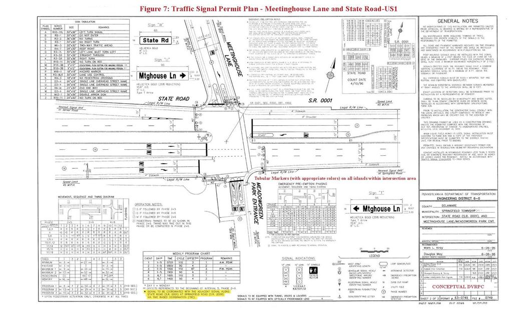
26 Case Study Corridor: State Road, US 1 (Springfield and Marple Townships, Delaware County) 21 TABLE 4 PROPOSED IMPROVEMENTS STATE ROAD US 1 at MEADOWGREEN PARK ENTRANCE \ MEETINGHOUSE LANE (See Figure 7) Existing Conditions Proposed Improvements Signalized Intersection US 1 NB; 2 through lanes and 1 through lane (frontage road), and 1 right turn lane (frontage road) US 1 SB; 2 through lanes and 1 separate left turn lane Meadowgreen Park Entrance; 1 left turn lane and 1 right turn lane. Meetinghouse Lane; 1 through \ right turn lane and 1 separate left turn lane. (One Way Street) Source: DVRPC, 2006 Reestablish signal coordination with the signal at Springfield Road Add Tubular Markers on all Islands throughout the Intersection area REINSTALL ALL MISSING PERMIT SIGNAGE The reestablishment of signal coordination offers the opportunity to moderate traffic speeds and improve level of service along US 1. More effective use of green time on US 1 may be apportioned to other phases / approaches at the intersection. Installation of tubular markers on islands and replacement of missing signal permit signs should help reduce island and confusion related accidents. These improvements should improve traffic flow and reduce the number of angle and rear end accidents. Other improvements related to the Meadowgreen Park Entrance approach to State Road US 1 were investigated and conceptually designed as part of this study, but were not acceptable to Springfield Township. US 1 looking SB at Meadowgreen Park Entrance \ Meetinghouse Lane
27
28
29

30 Case Study Corridor: State Road, US 1 (Springfield and Marple Townships, Delaware County) 25 TABLE 5 PROPOSED IMPROVEMENTS STATE ROAD US 1 at SPRINGFIELD ROAD (See Figure 8) Existing Conditions Proposed Improvements Signalized Intersection US 1 NB; 1 separate left turn lane, 2 through lanes, and 1 separate right turn lane US 1 SB; 1 separate left turn lane, 1 through lane, and 1 through \ right lane Springfield Road; 1 through \ right lane, and 1 separate left turn lane on both approaches Source: DVRPC, 2006 Reestablish signal coordination with the signal at Meetinghouse Lane Add Tubular Markers on all Islands throughout the Intersection area Close 1 of the gas station s access driveways on Springfield Road (Due to proximity to the intersection) REINSTALL ALL MISSING PERMIT SIGNAGE The reestablishment of signal coordination should improve traffic flow and thus reduce the need of drivers to cheat the clearance interval. This would directly help reduce the 67 percent rate of angle accidents. The removal of one gas station access point will reduce confusion and conflict movement at the intersection. The replacement of missing signal permit signs and demarcation of islands with tubular markers should reduce confusion and hit fixed object related accidents. These proposed improvements should improve traffic flow and reduce angle and rear end accidents. US 1 looking SB at Springfield Road
 Springfield Road WB at US 1 Gas Station entrance proposed for")
31 26 Case Study Corridor: State Road, US 1 (Springfield and Marple Townships, Delaware County) Springfield Road WB at US 1 Gas Station entrance proposed for closure

32
33
34 Case Study Corridor: State Road, US 1 (Springfield and Marple Townships, Delaware County) 29 TABLE 6 PROPOSED IMPROVEMENTS STATE ROAD US 1 at BUTTONWOOD DRIVE (See Figure 9) Existing Conditions Proposed Improvements Unsignalized Intersection US 1 NB; 3 through lanes, and a two-way left turn lane US 1 SB; 2 through lanes and a two-way left turn lane Buttonwood Drive; 1 left \ through \ right lane on each approach. Approach offset approximately 150 feet at US 1 State Road Source: DVRPC, 2006 US 1; remove the shared left turn lane by extending the concrete median from the Meetinghouse Lane intersection to the Springfield Road intersection. Add All Traffic Must Turn Right signs on both Buttonwood Drive approaches. These proposed improvements should eliminate the potential for head on accidents and significantly reduce rear end accidents. There is a 15 percent to 57 percent reduction in crashes on four lane roads when a two-way left turn lane is replaced with a nontraversable median (source, Access Management Manual, Transportation Research Board, 2003). In addition to safety considerations, this recommendation (median closure) is consistent with limiting local access to roadways classified as Other Freeways and Expressways. Strategies which reduce or eliminate the amount of turning vehicles (i.e., a nontraversable median on US 1) will reduce crash potential as well as severity.
")
 Figure 9 Median")


35 30 Case Study Corridor: State Road, US 1 (Springfield and Marple Townships, Delaware County) US 1 looking SB at Buttonwood Drive proposed median closure (inset: existing condition) Figure 9 Median Closure Typical Section 12' 16' 12' EXISTING THROUGH LANE EXISTING 2 WAY LEFT TURN LANE EXISTING THROUGH LANE PROPOSED CONCRETE MEDIAN WIDTH VARIES 4' TO 16' 1' 2' 2' 1' FULL DEPTH PAVEMENT BITUMINOUS WRG. CRSE. 4" PLAIN CEMENT CONCRETE PAVEMENT TYPICAL SECTION US BUTTONWOOD DRIVE (LOOKING SB) N.T.S. MOUNTABLE CURB
36 Case Study Corridor: State Road, US 1 (Springfield and Marple Townships, Delaware County) 31 The cost estimate for the entire set of State Road US 1 corridor improvements is detailed in Table 7. TABLE 7 - STATE ROAD (US 1) CORRIDOR IMPROVEMENTS ENGINEERING AND CONSTRUCTION PRELIMINARY COST ESTIMATE Item Description Unit Quantity Unit Cost Item Cost Excavation C.Y $ 4,375 4' Plain Cement Concrete Pavement S.Y $ 16,250 Curb (Plain or Mountable) L.F $ 13,500 *Bituminous Concrete Pavement L.S. $ 6,500 * Paving associated with the installation of the concrete median Post Mounted Signs S.F $ 3,850 Pavement Marking L.S. L.S. $ 1,500 Tubular Markers EA $ 3,325 Traffic Control L.S. L.S. $ 10,000 *Signal Coordination L.S. L.S. $ 6,000 *Meetinghouse Lane to Springfield Road, controller and gps device at each intersection Subtotal $ 65, % $ 9, % $ 13,060 Total $ 88,155 Source: DVRPC, 2006 The cost of the median Buttonwood Drive is estimated to be approximately $ 70,000.
37 Case Study Corridor: State Road, US 1 (Springfield and Marple Townships, Delaware County) 32 5 CONCLUSIONS / NEXT STEPS This case study addresses safety and mobility of US 1 State Road, a four lane expressway and principal arterial through a maturely developed suburban area. Recommendations have been developed based upon technical analyses and field observations. Specific improvements have been identified which focus upon strategies that control or define traffic movement at four median openings between Collins Drive and Springfield Road. The most significant improvement is a proposed median closure at the unsignalized Buttonwood Drive offset intersection. Costs for the complete improvement program are estimated at $ 90,000. $ 70,000 representing the estimated cost of the recommended median closure at Buttonwood Drive and $ 20,000 for the balance of the program which includes improved signage and pavement markings at signalized intersections, and reestablishing coordinated traffic signalization through the segment. The median closure probably (if implemented) would be best constructed by PennDOT under a maintenance contract while the balance of the program would fall within the scope of typical township maintenance. In addition, DVRPC in partnership with Delaware County Planning, PENNDOT, and the Federal Highway Administration will take steps to realign the highway functional classification of State Road between Collins Drive and Springfield Road from Expressway to Principal Arterial to more precisely describe the highway s character. The recommendations forwarded in the body of this report are not compromised by this action. With this report, DVRPC has identified and proposed improvement to the congested regional highway network emphasizing the principles of highway access management for state and local highways being promoted by PennDOT. The recommendations may require further study and coordination between the municipality and PennDOT before they can be implemented. The report, its recommendations and conceptual plans have been developed to foster those conversations and potential actions.
38 Case Study Corridor: State Road, US 1 (Springfield and Marple Townships, Delaware County) 33 6 REFERENCES Pennsylvania Department of Transportation, Access Management Model Ordinances For Pennsylvania Municipalities Handbook, April Federal Highway Administration, Manual of Uniform Traffic Control Devices, December Transportation Research Board, Access Management Manual, American Association of State Highway and Transportation Officials, Geometric Design of Highways and Streets, 2004.
39

40
41
42 DELAWARE VALLEY REGIONAL PLANNING COMMISSION Publication Abstract Title: Access Management Along Pennsylvania Highways in the Delaware Valley State Road US 1 Case Study Corridor Date Published: June 2006 Publication No: Geographic Area Covered: Springfield and Marple townships in Delaware County, Pennsylvania. Key Words: Access Management, congestion management, traffic safety, accident mitigation, corridor planning, model ordinance, growth management ABSTRACT This report was prepared in support of PENNDOT s effort to establish model access management ordinances for use by municipalities statewide. A case study of State Road US 1 between Collins Drive and Springfield Road was prepared to illustrate the tangible benefits of implementing access management strategies along state and local highways. The work was performed with the participation of member governments, regional transportation providers, PENNDOT, and the affected municipalities. The project began with the documentation of existing conditions along the State Road US 1 corridor. Access management related problem areas and specific issues were identified and studied in specific detail. Improvement recommendations addressing congestion and safety concerns along the corridor were formulated based on PENNDOT s Access Management Model Ordinances for Pennsylvania Municipalities Handbook, The Manual on Uniform Traffic Control Devices, the Transportation Research Board s Access Management Manual, and the American Association of State Highway and Transportation Officials Geometric Design of Highways and Streets. Improvement recommendations have been illustrated on traffic signal permit drawings and on a corridor conceptual plan; and preliminary cost estimates for the improvements are provided. For More Information Contact: Delaware Valley Regional Planning Commission 190 N. Independence Mall West, 8 th Floor Philadelphia PA Phone: Fax: Website: Staff Contacts: Direct Phone: Dennis Crosby, Project Engineer dcrosby@dvrpc.org Jerry Coyne, Project Manager jcoyne@dvrpc.org
43 190 N. Independence Mall West 8th Floor Philadelphia, PA
Executive Summary Introduction Methodology...3 Level of Service (LOS) Analysis...4. Study Location... 5
 Analysis...4. Study Location... 5") The Delaware Valley Regional Planning Commission is dedicated to uniting the region s elected officials, planning professionals, and the public with a common vision of making a great region even greater.
The Delaware Valley Regional Planning Commission is dedicated to uniting the region s elected officials, planning professionals, and the public with a common vision of making a great region even greater.
M-58 HIGHWAY ACCESS MANAGEMENT STUDY Mullen Road to Bel-Ray Boulevard. Prepared for CITY OF BELTON. May 2016
 M-58 HIGHWAY ACCESS MANAGEMENT STUDY Prepared for CITY OF BELTON By May 2016 Introduction Missouri State Highway 58 (M-58 Highway) is a major commercial corridor in the City of Belton. As development has
Chapter 4 Traffic Analysis
 Chapter 4 Traffic Analysis PURPOSE The traffic analysis component of the K-68 Corridor Management Plan incorporates information on the existing transportation network, such as traffic volumes and intersection
Transportation Impact Study for Abington Terrace
 Transportation Impact Study for Abington Terrace Abington Township, Montgomery County, PA Sandy A. Koza, P.E., PTOE PA PE License Number PE059911 Prepared by McMahon Associates, Inc. 425 Commerce Drive,
Burlington County Bicycle Level of Service Study
 Burlington County Bicycle Level of Service Study June 2013 The Delaware Valley Regional Planning Commission is dedicated to uniting the region s elected officials, planning professionals, and the public
Chapter 2: Standards for Access, Non-Motorized, and Transit
 Standards for Access, Non-Motorized, and Transit Chapter 2: Standards for Access, Non-Motorized, and Transit The Washtenaw County Access Management Plan was developed based on the analysis of existing
Traffic Impact Analysis Walton Acres at Riverwood Athletic Club Clayton, NC
 Traffic Impact Analysis Walton Acres at Riverwood Athletic Club Clayton, NC 1. TABLE OF CONTENTS INTRODUCTION...1 1.1. Site Location and Study Area...1 1.2. Proposed Land Use and Site Access...2 1.3.
CHAPTER 7 ACCESS MANAGEMENT. Background. Principles of Access Management. Hennepin County Transportation Systems Plan (HC-TSP)
") CHAPTER 7 ACCESS MANAGEMENT Background Principles of Access Management Hennepin County Transportation Systems Plan (HC-TSP) Chapter 7 Access Management 7.1 Background Access management has become an important
CHAPTER 7 ACCESS MANAGEMENT Background Principles of Access Management Hennepin County Transportation Systems Plan (HC-TSP) Chapter 7 Access Management 7.1 Background Access management has become an important
Evaluation of M-99 (Broad Street) Road Diet and Intersection Operational Investigation
 Road Diet and Intersection Operational Investigation") Evaluation of M-99 (Broad Street) Road Diet and Intersection Operational Investigation City of Hillsdale, Hillsdale County, Michigan June 16, 2016 Final Report Prepared for City of Hillsdale 97 North Broad
Evaluation of M-99 (Broad Street) Road Diet and Intersection Operational Investigation City of Hillsdale, Hillsdale County, Michigan June 16, 2016 Final Report Prepared for City of Hillsdale 97 North Broad
FINAL DESIGN TRAFFIC TECHNICAL MEMORANDUM
 FINAL DESIGN TRAFFIC TECHNICAL MEMORANDUM July 2014 FINAL (SR 43) Project Development and Environment Study From State Road 60 (Adamo Drive) to I-4 (SR 400) Hillsborough County, Florida Work Program Item
Glenn Avenue Corridor Traffic Operational Evaluation
 Glenn Avenue Corridor Traffic Operational Evaluation PREPARED FOR: THE CITY OF AUBURN PREPARED BY: DECEMBER 2007 Glenn Avenue Corridor Study--Auburn, Alabama TABLE OF CONTENTS Introduction... 1 Background
CITY OF WEST LAKE HILLS. Forest View Neighborhood Traffic Calming Study
 CITY OF WEST LAKE HILLS 901 South Mopac Expressway Building V, Suite 220 Austin, Texas 78746 Texas P.E. Firm Registration No. F-929 Klotz Associates Final Report Submittal: March 20, 2015 Revised Final
City of Homewood Transportation Plan
 City of Homewood Transportation Plan Prepared for: City of Homewood, Alabama Prepared by: Skipper Consulting, Inc. May 2007 TABLE OF CONTENTS INTRODUCTION... 1 BACKGROUND INFORMATION... 1 EXISTING TRANSPORTATION
Access Location, Spacing, Turn Lanes, and Medians
 Design Manual Chapter 5 - Roadway Design 5L - Access Management 5L-3 Access Location, Spacing, Turn Lanes, and Medians This section addresses access location, spacing, turn lane and median needs, including
Roundabout Feasibility Memorandum
 Roundabout Feasibility Memorandum To From Gwen Pipkin Bill Howell Date June 18, 2013 Subject Roundabout Feasibility Study SR 29 PD&E Study From Oil Well Road to SR 82 Collier County, FL FPID 417540-1-22-01
APPENDIX E: Transportation Technical Report
 New Jersey Pennsylvania Lackawanna Cut-Off Passenger Rail Service Reston Project Environmental Assessment APPENDIX E: Transportation Technical Report E.1 Introduction As part of the overall environmental
Traffic Circulation Study for Neighborhood Southwest of Mockingbird Lane and Airline Road, Highland Park, Texas
 ARIZONA TEXAS NEW MEXICO OKLAHOMA February 13, 2015 Mr. Meran Dadgostar P.E., R.S. Town of Highland Park 4700 Drexel Dr. Highland Park, Texas 75205 Re: Traffic Circulation Study for Neighborhood Southwest
3.0 PROJECT DESCRIPTION
 The following section of the Draft EIR contains a description of the proposed Elk Grove Boulevard/SR 99 Interchange Modification project, consistent with the requirements of CEQA Guidelines Section 15124.
Capital Region Council of Governments
 March 23, 2018 Capital Region Council of Governments PROJECT CONCEPT REPORT Realignment of Swamp and Northfield Road s approaches to Route 44 (Boston Turnpike) Town of Coventry SUMMARY: The Town of Coventry
PennDOT Access Management Model Ordinances Training
 PennDOT Access s Training Trainers: Chad Dixson, AICP, TPD Angela Watson, PB Objective of Today Assist Pennsylvania s municipalities and transportation professionals in better understanding the benefits
METHODOLOGY. Signalized Intersection Average Control Delay (sec/veh)
") Chapter 5 Traffic Analysis 5.1 SUMMARY US /West 6 th Street assumes a unique role in the Lawrence Douglas County transportation system. This principal arterial street currently conveys commuter traffic
Chapter 5 Traffic Analysis 5.1 SUMMARY US /West 6 th Street assumes a unique role in the Lawrence Douglas County transportation system. This principal arterial street currently conveys commuter traffic
A plan for improved motor vehicle access on Railroad Avenue in Provincetown
 A plan for improved motor vehicle access on Railroad Avenue in Provincetown February 2011 A plan for improved motor vehicle access on Railroad Avenue in Provincetown INTRODUCTION AND PROBLEM IDENTIFICATION
ADOT Statewide Bicycle and Pedestrian Program Summary of Phase IV Activities APPENDIX B PEDESTRIAN DEMAND INDEX
 ADOT Statewide Bicycle and Pedestrian Program Summary of Activities APPENDIX B PEDESTRIAN DEMAND INDEX May 24, 2009 Pedestrian Demand Index for State Highway Facilities Revised: May 29, 2007 Introduction
As the Toronto Transit Commission (TTC) operates a transit service on Avenue Road, City Council approval of this report is required.
 operates a transit service on Avenue Road, City Council approval of this report is required.") REPORT FOR ACTION Corridor Safety Review - Avenue Road Date: September 27, 2017 To: Toronto and East York Community Council From: Acting Director, Transportation Services, Toronto and East York District
REPORT FOR ACTION Corridor Safety Review - Avenue Road Date: September 27, 2017 To: Toronto and East York Community Council From: Acting Director, Transportation Services, Toronto and East York District
Highway 49, Highway 351 and Highway 91 Improvements Feasibility Study Craighead County
 Highway 49, Highway 351 and Highway 91 Improvements Feasibility Study Craighead County Executive Summary March 2015 Highway 49, Highway 351 and Highway 91 Improvements Feasibility Study Craighead County
Gwinnett County Department of Transportation SR 324 / Gravel Springs Road at I-85 / SR 403 Interchange Project Number F , PI No.
 June 4, 2015 Dear Resident: Thank you for attending this public information meeting for the proposed SR 324 / Gravel Springs Road at I-85 Interchange. The purpose of this meeting is two-fold: to provide
Truck Climbing Lane Traffic Justification Report
 ROUTE 7 (HARRY BYRD HIGHWAY) WESTBOUND FROM WEST MARKET STREET TO ROUTE 9 (CHARLES TOWN PIKE) Truck Climbing Lane Traffic Justification Report Project No. 6007-053-133, P 101 Ι UPC No. 58599 Prepared by:
5858 N COLLEGE, LLC N College Avenue Traffic Impact Study
 5858 N COLLEGE, LLC nue Traffic Impact Study August 22, 2016 Contents Traffic Impact Study Page Preparer Qualifications... 1 Introduction... 2 Existing Roadway Conditions... 5 Existing Traffic Conditions...
Troutbeck Farm Development
 Troutbeck Farm Development Willistown Township, Chester County PA For Submission To: Willistown Township Last Revised: October, 4 TPD# INLM.A. 5 E. High Street Suite 65 Pottstown, PA 9464 6.36.3 TPD@TrafficPD.com
TRAFFIC ACCIDENT ANALYSIS
 TRAFFIC ACCIDENT ANALYSIS Westheimer at Chimney Rock and Westheimer at Dunvale Prepared for Prepared by Klotz Associates, Inc. 1160 Dairy Ashford, Suite 500 Houston, Texas 77079 The preparation of this
City of Wayzata Comprehensive Plan 2030 Transportation Chapter: Appendix A
 A1. Functional Classification Table A-1 illustrates the Metropolitan Council s detailed criteria established for the functional classification of roadways within the Twin Cities Metropolitan Area. Table
BETHEL ROAD AND SEDGWICK ROAD CORRIDOR STUDY
 DRAFT PLAN City Council Meeting August 14, 2017 STUDY AREA Sedgwick Corridor State Route 160, principal arterial with Class 3 access management designation, commuter and freight route, connection to SR
Existing Conditions. Date: April 16 th, Dan Holderness; Coralville City Engineer Scott Larson; Coralville Assistant City Engineer
 Date: April 16 th, 2015 To: From: Re: Dan Holderness; Coralville City Engineer Scott Larson; Coralville Assistant City Engineer Darian Nagle-Gamm, Traffic Engineering Planner Highway 6 (2 nd Street) /
Recommended Roadway Plan Section 2 - Land Development and Roadway Access
 Recommended Roadway Plan Section 2 - Land Development and Roadway Access SECTION 2 Land Development and Roadway Access 2.1 Land Use and Access Management The Federal Highway Administration (FHWA) defines
Figure 1: Vicinity Map of the Study Area
 ARIZONA TEXAS NEW MEXICO OKLAHOMA May 5, 2016 Mr. Anthony Beach, P.E. BSP Engineers 4800 Lakewood Drive, Suite 4 Waco, Texas 76710 Re: Intersection and Access Analysis along Business 190 in Copperas Cove
State Street Transit Signal Priority Study
 State Street Transit Signal Priority Study April 2015 The Delaware Valley Regional Planning Commission is dedicated to uniting the region s elected officials, planning professionals, and the public with
Traffic Impact Analysis Chatham County Grocery Chatham County, NC
 Chatham County Grocery Chatham County, NC TABLE OF CONTENTS 1. INTRODUCTION... 1 1.1. Location and Study Area... 1 1.2. Proposed Land Use and Access... 2 1.3. Adjacent Land Uses... 2 1.4. Existing ways...
Route 29 Corridor Assessment Update. Development of Possible Solutions
 Route 29 Corridor Assessment Update Development of Possible Solutions Public Workshop #3 October 27, 2016 Purpose of Developing Possible Solutions Recap of where we ve been and timeline for moving forward
ENHANCED PARKWAY STUDY: PHASE 2 CONTINUOUS FLOW INTERSECTIONS. Final Report
 Preparedby: ENHANCED PARKWAY STUDY: PHASE 2 CONTINUOUS FLOW INTERSECTIONS Final Report Prepared for Maricopa County Department of Transportation Prepared by TABLE OF CONTENTS Page EXECUTIVE SUMMARY ES-1
WYDOT DESIGN GUIDES. Guide for. NHS Arterial (Non-Interstate)
") WYDOT DESIGN GUIDES Guide for NHS Arterial (Non-Interstate) 2014 GUIDE FOR NATIONAL HIGHWAY SYSTEM (NHS) HIGHWAYS (NHS ARTERIALS, Non-Interstate) PRESERVATION REHABILITATION RECONSTRUCTION INTRODUCTION
WYDOT DESIGN GUIDES Guide for NHS Arterial (Non-Interstate) 2014 GUIDE FOR NATIONAL HIGHWAY SYSTEM (NHS) HIGHWAYS (NHS ARTERIALS, Non-Interstate) PRESERVATION REHABILITATION RECONSTRUCTION INTRODUCTION
Executive Summary Route 30 Corridor Master Plan
 Route Corridor Master Plan Project Overview The Route Corridor Master Plan is a coordinated multimodal transportation and land use plan for the entire stretch of Route through East Whiteland Township,
CHAPTER 2G. PREFERENTIAL AND MANAGED LANE SIGNS
 2011 Edition - Revision 2 Page 275 Section 2G.01 Scope CHAPTER 2G. PREFERENTIAL AND MANAGED LANE SIGNS 01 Preferential lanes are lanes designated for special traffic uses such as high-occupancy vehicles
HIGHBURY AVENUE/HAMILTON ROAD INTERSECTION IMPROVEMENTS PUBLIC INFORMATION CENTRE 1 MAY 14, 2015
 HIGHBURY AVENUE/HAMILTON ROAD INTERSECTION IMPROVEMENTS Municipal Class Environmental Assessment PUBLIC INFORMATION CENTRE 1 MAY 14, 2015 ACCESSIBILITY Under the Accessibility Standards 2015 for Customer
Route 28 (South Orleans Road)/Route 39 (Harwich Road)/Quanset Road Intersection
/Route 39 (Harwich Road)/Quanset Road Intersection") TRAFFIC FEASIBILITY STUDY Route 28 (South Orleans Road)/Route 39 (Harwich Road)/Quanset Road Intersection Orleans, Massachusetts Prepared for: Town of Orleans Prepared by: Fay, Spofford & Thorndike, LLC
TRAFFIC FEASIBILITY STUDY Route 28 (South Orleans Road)/Route 39 (Harwich Road)/Quanset Road Intersection Orleans, Massachusetts Prepared for: Town of Orleans Prepared by: Fay, Spofford & Thorndike, LLC
Military Road Safety Improvements
 Military Road Safety Improvements 26 th Road North to 31 st Street North SUMMARY OF DATA REVIEW AND PRELIMINARY RECOMMENDATIONS Prepared for: Department of Environmental Services Traffic Engineering and
Donahue Drive Corridor Traffic Operational Evaluation
 Donahue Drive Corridor Traffic Operational Evaluation PREPARED FOR: THE CITY OF AUBURN PREPARED BY: JANUARY 2007 Donahue Drive Corridor Study--Auburn, Alabama TABLE OF CONTENTS Introduction... 1 Background
Shockoe Bottom Preliminary Traffic and Parking Analysis
 Shockoe Bottom Preliminary Traffic and Parking Analysis Richmond, Virginia August 14, 2013 Prepared For City of Richmond Department of Public Works Prepared By 1001 Boulders Pkwy Suite 300, Richmond, VA
Summary: Mercer County Princeton Avenue & Spruce Street Study January 2009
 Summary: Several recent studies have assessed potential development and redevelopment opportunities in the Mercer Crossing area of Trenton, Ewing, and Lawrence. This Princeton Avenue and Spruce Street
TRAFFIC ACTION PLAN. Laurie Meadows Neighborhood CITY OF SAN MATEO
 TRAFFIC ACTION PLAN Laurie Meadows Neighborhood CITY OF SAN MATEO Draft January 2017 Table of Contents Introduction... 2 The Traffic Forum Process... 5 Neighborhood Traffic Issues... 7 Neighborhood Recommendations
Route 7 Corridor Study
 Route 7 Corridor Study Executive Summary Study Area The following report analyzes a segment of the Virginia State Route 7 corridor. The corridor study area, spanning over 5 miles in length, is a multi
RSTF Measurements and Status
 RSTF Measurements and Status Items in green text are on or ahead of target. Items in red text need attention. Objective & Measures Status November, 2011 Winter, 3/8/12 Build, Maintain, & Leverage Partnerships
Request for Authorization to Open Public Comment Period
 Request for Authorization to Open Public Comment Period May 12, 2015 LRP, TIPs, and Conformity Reasons for Requested Action: LRP and TIP Amendment to Connections 2040 LRP, and Draft FY 2016 TIP for New
I-95 Northbound at US 1 (Exit 126) Design and Study Final Report
 Design and Study Final Report") I-95 Northbound at US 1 (Exit 126) Design and Study Final Report July 2018 Prepared by: Prepared for: TABLE OF CONTENTS 1 Introduction... 1 Study Area Limits... 1 Purpose and Need of the Study... 1 Safety
I-95 Northbound at US 1 (Exit 126) Design and Study Final Report July 2018 Prepared by: Prepared for: TABLE OF CONTENTS 1 Introduction... 1 Study Area Limits... 1 Purpose and Need of the Study... 1 Safety
Traffic Impact Study WestBranch Residential Development Davidson, NC March 2016
 Traffic Impact Study WestBranch Residential Development Davidson, NC March 216 TRAFFIC IMPACT STUDY FOR THE WestBranch Residential Development LOCATED IN DAVIDSON, NC Prepared For: Lennar Carolinas, LLC
Subject: Solberg Avenue / I-229 Grade Separation: Traffic Analysis
 MEMORANDUM Transportation Bill Troe, AICP Jason Carbee, AICP 12120 Shamrock Plaza Suite 300 Omaha, NE 68154 (402) 334-8181 (402) 334-1984 (Fax) To: Project File Date: Subject: Solberg Avenue / I-229 Grade
Brian McHugh, Buckhead Community Improvement District. SUBJECT: Wieuca Road at Phipps Boulevard Intersection Improvements Project
 MEMO TO: FROM: Brian McHugh, Buckhead Community Improvement District Jagan Kaja, AICP, WSP Parsons Brinckerhoff SUBJECT: Wieuca Road at Phipps Boulevard Intersection Improvements Project DATE: October
Taming Traffic: Bethlehem Pike Phase II - Road Diet Evaluation
 Taming Traffic: Bethlehem Pike Phase II - Road Diet Evaluation March 2012 i Taming Traffic: Bethlehem Pike Phase II - Road Diet Evaluation March 2012 i The Delaware Valley Regional Planning Commission
Appendix A: Safety Assessment
 Appendix A: Safety Assessment Safety Assessment Appendix A A Statement of Philosophy The efficient and responsible investment of resources in addressing safety problems is a difficult task. Since crashes
TRAFFIC IMPACT ANALYSIS
 TRAFFIC IMPACT ANALYSIS FOR THE CHAMPAIGN UNIT#4 SCHOOL DISTRICT PROPOSED HIGH SCHOOL (SPALDING PARK SITE) IN THE CITY OF CHAMPAIGN Final Report Champaign Urbana Urbanized Area Transportation Study 6/24/2014
TRANSPORTATION ANALYSIS REPORT US Route 6 Huron, Erie County, Ohio
 TRANSPORTATION ANALYSIS REPORT US Route 6 Huron, Erie County, Ohio December 12, 2012 Prepared for: The City of Huron 417 Main Huron, OH 44839 Providing Practical Experience Technical Excellence and Client
TRAFFIC IMPACT STUDY And A TRAFFIC SIGNAL WARRANT ANALYSIS FOR A SENIOR LIVING AND APARTMENT DEVELOPMENT
 TRAFFIC IMPACT STUDY And A TRAFFIC SIGNAL WARRANT ANALYSIS FOR A SENIOR LIVING AND APARTMENT DEVELOPMENT DEERFIELD TOWNSHIP, WARREN COUNTY, OHIO Nantucket Circle and Montgomery Road () Prepared for: ODLE
INTRODUCTION THOROUGHFARE SYSTEM CLASSIFICATIONS
 INTRODUCTION The thoroughfare plan will assist public officials in the development of a specialized system for efficient and safe movement of vehicular traffic while minimizing potential conflicts with
Traffic Study of Fuller Street, Cady Street, West Street and West Avenue. Final Report
 Traffic Study of Fuller Street, Cady Street, West Street and West Avenue Final Report July 2005 Prepared for: Town of Ludlow Prepared by: Pioneer Valley Planning Commission 26 Central Street West Springfield,
4. ENVIRONMENTAL IMPACT ANALYSIS 9. TRANSPORTATION AND TRAFFIC
 4. ENVIRONMENTAL IMPACT ANALYSIS 9. TRANSPORTATION AND TRAFFIC 4.9.1 INTRODUCTION The following section addresses the Proposed Project s impact on transportation and traffic based on the Traffic Study
#!! "$% ##! &! # '#! % $ #!
 Executive Summary US Highway 16 (US 16) is the primary corridor connecting Rapid City to the Black Hills region. It serves a growing population of commercial and residential traffic, as well as seasonal
WYDOT DESIGN GUIDES. Guide for. Non-NHS State Highways
 WYDOT DESIGN GUIDES Guide for Non-NHS State Highways 2014 GUIDE FOR Non-NATIONAL HIGHWAY SYSTEM (Non-NHS) STATE HIGHWAYS PRESERVATION REHABILITATION RECONSTRUCTION INTRODUCTION This Guide is directed to
MEMORANDUM. DATE March 1, 2012 TO Town of Milton Mark Abbott, Seth Asante, and Efi Pagitsas Boston Region MPO Staff
 MEMORANDUM DATE March 1, 212 TO Town of Milton FROM RE Mark Abbott, Seth Asante, and Efi Pagitsas Boston Region MPO Staff FFY 211 Safety and Operations Analyses at Selected Boston Region MPO Intersections:
ALLEY 24 TRAFFIC STUDY
 ALLEY 24 TRAFFIC STUDY in City of Frostburg, Maryland January 2013 3566 Teays Valley Road Hurricane, WV Office: (304) 397-5508 www.denniscorporation.com Alley 24 Traffic Study January 2013 Frostburg, Maryland
INDUSTRIAL BUILDING 3009 HAWTHORNE ROAD CITY OF OTTAWA TRANSPORTATION OVERVIEW REVISED. Prepared for: Canada Inc.
 INDUSTRIAL BUILDING 3009 HAWTHORNE ROAD CITY OF OTTAWA TRANSPORTATION OVERVIEW REVISED Prepared for: 7849648 Canada Inc. Octiober 1, 2015 114-598 Overview_2.doc D. J. Halpenny & Associates Ltd. Consulting
Access Management in the Vicinity of Intersections
 Access Management in the Vicinity of Intersections FHWA-SA-10-002 Technical Summary Photo: Ralph Bentley (used with permission) 0 Access Management is: The design, implementation and management of entry
FLORIDA DEPARTMENT OF TRANSPORTATION DISTRICT 7 DISTRICT WIDE BICYCLE/PEDESTRIAN ACCESS TO TRANSIT SAFETY ASSESSMENT AND IMPROVEMENT PLAN
 FLORIDA DEPARTMENT OF TRANSPORTATION DISTRICT 7 DISTRICT WIDE BICYCLE/PEDESTRIAN ACCESS TO TRANSIT SAFETY ASSESSMENT AND IMPROVEMENT PLAN TRANSIT SAFETY ASSESSMENT SR 55/US 19 AT 80 TH AVE N DRAFT JUNE
Intersection Traffic Control Feasibility Study
 Intersection Traffic Control Feasibility Study CSAH 9 at CSAH 60 (185th Avenue) Prepared For: Dakota County Transportation Department Western Service Center 14955 Galaxie Avenue, 3rd Floor Apple Valley,
MUTCD Part 6G: Type of Temporary Traffic Control Zone Activities
 MUTCD Part 6G: Type of Temporary Traffic Control Zone Activities 6G.01 Typical Applications Each temporary traffic control (TTC) zone is different. Many variables, such as location of work, highway type,
CITY OF SASKATOON COUNCIL POLICY
 ORIGIN/AUTHORITY Clause 1, Report No. 1-1980 and Clause 4, Report No. 22-1990 of the Works and Utilities Committee; Clause 6, Report No. 17-2004 of the Planning and Operations Committee; and Clause D5,
PRELIMINARY DRAFT WADDLE ROAD / I-99 INTERCHANGE PROJECT ALTERNATIVE ANALYSIS FINAL TRAFFIC SUMMARY REPORT
 PRELIMINARY DRAFT WADDLE ROAD / I-99 INTERCHANGE PROJECT ALTERNATIVE ANALYSIS FINAL TRAFFIC SUMMARY REPORT Prepared by: In Association with: November 2013 EXECUTIVE SUMMARY Patton Township, in partnership
7.0 FREEWAYS CONGESTION HOT SPOT PROBLEM & IMPROVEMENT PROJECT ANALYSIS & DEFINITION
 7.0 FREEWAYS CONGESTION HOT SPOT PROBLEM & IMPROVEMENT PROJECT ANALYSIS & DEFINITION 7.1 INTRODUCTION & METHODOLOGY FEASIBILITY REPORT Congestion hot spot problem locations have been assessed using the
DEPARTMENT OF ENVIRONMENTAL SERVICES. North Harrison Street (Lee Highway to Little Falls Road) Comparative Analysis. Prepared for:
 Comparative Analysis. Prepared for:") DEPARTMENT OF ENVIRONMENTAL SERVICES North Harrison Street (Lee Highway to Little Falls Road) Comparative Analysis Prepared for: Arlington County Department of Environmental Services 2100 Clarendon Boulevard,
DEPARTMENT OF ENVIRONMENTAL SERVICES North Harrison Street (Lee Highway to Little Falls Road) Comparative Analysis Prepared for: Arlington County Department of Environmental Services 2100 Clarendon Boulevard,
TOWN OF CHAPEL HILL POLICY AND PROCEDURES FOR TRAFFIC CALMING MEASURES
 TOWN OF CHAPEL HILL POLICY AND PROCEDURES FOR TRAFFIC CALMING MEASURES (Adopted by the Town Council on June 30, 2004) (Revised December 6, 2010) (Revised February 8, 2016) POLICY AND PROCEDURES FOR TRAFFIC
3.9 - Transportation and Traffic
 Transportation and Traffic 3.9 - Transportation and Traffic This section describes the potential transportation and traffic effects of project implementation on the project site and its surrounding area.
OFFICE/RETAIL DEVELOPMENT 1625 BANK STREET OTTAWA, ONTARIO TRANSPORTATION BRIEF. Prepared for: Canada Inc.
 OFFICE/RETAIL DEVELOPMENT 1625 BANK STREET OTTAWA, ONTARIO TRANSPORTATION BRIEF Prepared for: 9402209 Canada Inc. December 15, 2015 115-625 Report_2.doc D. J. Halpenny & Associates Ltd. Consulting Transportation
Arterial Management Plan for US Route 250 and State Route 623
 Arterial Management Plan for US Route 250 and State Route 623 June 25, 2014 Brad Shelton, AICP Access Management and Traffic Impact Analysis Programs Manager Transportation and Mobility Planning Division
CITY OF OAKLAND. 27th Street Bikeway Feasibility and Design. Final Report (v3) March 23, Kimley-Horn and Associates, Inc.
 March 23, Kimley-Horn and Associates, Inc.") CITY OF OAKLAND 27th Street Bikeway Feasibility and Design Final Report (v3) March 23, 2007 PREPARED BY: Kimley-Horn and Associates, Inc. Table of Contents 1. Introduction 3 2. 27 th Street/Bay Place Corridor
CITY OF OAKLAND 27th Street Bikeway Feasibility and Design Final Report (v3) March 23, 2007 PREPARED BY: Kimley-Horn and Associates, Inc. Table of Contents 1. Introduction 3 2. 27 th Street/Bay Place Corridor
Los Altos Hills Town Council - June 18, 2015 Palo Alto City Council June 22, AGENDA ITEM #2.B Presentation
 Los Altos Hills Town Council - June 18, 2015 Palo Alto City Council June 22, 2015 AGENDA ITEM #2.B Presentation Previous Presentations Los Altos Hills Town Council in May 2014 and February 2015 Palo Alto
Gateway Transportation Study
 Gateway Transportation Study Amherst, Massachusetts SUBMITTED TO University of Massachusetts Amherst Town of Amherst SUBMITTED BY Vanasse Hangen Brustlin, Inc. Watertown, Massachusetts March 213 Back of
3.0 ACCESS CONTROL PLAN - HARMONY ROAD (SH68)
") 3.0 ACCESS CONTROL PLAN - HARMONY ROAD (SH68) 3.1 Existing Conditions Roadway Physical Characteristics Typical Section The existing typical cross-section for SH68 is shown on Figure 3-1 and is comprised
3.0 ACCESS CONTROL PLAN - HARMONY ROAD (SH68) 3.1 Existing Conditions Roadway Physical Characteristics Typical Section The existing typical cross-section for SH68 is shown on Figure 3-1 and is comprised
THIS PAGE LEFT BLANK INTENTIONALLY
 GA SR 25 Spur at Canal Road Transportation Impact Analysis PREPARED FOR GLYNN COUNTY, GEORGIA 1725 Reynolds Street, Suite 300 Brunswick, Georgia 31520 PREPARED BY 217 Arrowhead Boulevard Suite 26 Jonesboro,
Project Description Form 8EE
 Project Description Form 8EE Basic Project Information Submitting Jurisdiction/Agency: Town of Dumfries Project Title: Route 1 (Fraley Blvd) Widening: Brady's Hill Road to Dumfries Road Project Location:
Town of Bethlehem. Planning Assessment. Bethlehem Town Board
 Town of Bethlehem US 9W Corridor Transportation Planning Assessment Presented e to: Bethlehem Town Board June 2009 Overview Study Background Route 9W Corridor Conditions and Improvements Selkirk Bypass
1.3.4 CHARACTERISTICS OF CLASSIFICATIONS
 Geometric Design Guide for Canadian Roads 1.3.4 CHARACTERISTICS OF CLASSIFICATIONS The principal characteristics of each of the six groups of road classifications are described by the following figure
Iowa Corridor Management Pilot Project Overview. Recommendations For A Corridor Management Program August 2004
 Iowa Corridor Management Pilot Project Overview Recommendations For A Corridor Management Program August 2004 Presentation Overview Project goals Pilot project selection process Analysis results Segment
CONTENTS EXECUTIVE SUMMARY 1
 CONTENTS CHAPTER PAGE EXECUTIVE SUMMARY 1 1 ISSUES AND PURPOSE OF THE ANALYSIS 2 1.1 Background 2 1.2 Analysis Area 2 1.3 Issues and Observations 3 1.4 Project and Public Meetings 3 2 LIST OF PREFERRED
PINESTONE TRAFFIC IMPACT STUDY Travelers Rest, South Carolina
 PINESTONE TRAFFIC IMPACT STUDY Travelers Rest, South Carolina Prepared for Longbranch Development Prepared by January 13, 219 ii Table of Contents Subject Page Signature Page... i Table of Contents...
TRANSPORTATION IMPACT STUDY PROPOSED RIVERFRONT 47 MIXED USE DEVELOPMENT
 November 2016 TRANSPORTATION IMPACT STUDY PROPOSED RIVERFRONT 47 MIXED USE DEVELOPMENT & Aspinwall Borough, Sharpsburg Borough & O Hara Township, Allegheny County, Pennsylvania Prepared for: Riverfront
CITY OF LOS ANGELES INTER-DEPARTMENTAL MEMORANDUM
 CITY OF LOS ANGELES INTER-DEPARTMENTAL MEMORANDUM Date: April 1, 219 To: Honorable City Council c/o City Clerk, Room 395, City Hall Attention: Honorable Mike Bonin, Chair, Transportation Committee From:
FAIRFIELD INN & SUITES HOTEL 135 THAD JOHNSON PRIVATE OTTAWA TRANSPORTATION BRIEF. Prepared for:
 FAIRFIELD INN & SUITES HOTEL 135 THAD JOHNSON PRIVATE OTTAWA TRANSPORTATION BRIEF Prepared for: Bona Building & Management Co. Ltd. Place Vanier, 333 North River Road Vanier, Ontario K1L 8B9 August 12,
OTTAWA TRAIN YARDS PHASE 3 DEVELOPMENT CITY OF OTTAWA TRANSPORTATION IMPACT STUDY. Prepared for:
 OTTAWA TRAIN YARDS PHASE 3 DEVELOPMENT CITY OF OTTAWA TRANSPORTATION IMPACT STUDY Prepared for: The Ottawa Train Yards Inc. 223 Colonnade Road South, Suite 212 Nepean, Ontario K2E 7K3 January 17, 2012
APPENDIX F SUPPLEMENTAL TRAFFIC DATA
 APPENDIX F SUPPLEMENTAL TRAFFIC DATA Environmental and Planning Consultants 440 Park Avenue South 7th Floor New York, NY 10016 tel: 212 696-0670 fax: 212 213-3191 www.akrf.com Draft Memorandum To: Michael
IMPLEMENTATION WORKBOOK
 Lawrence Township Bicycle and Pedestrian Planning Assistance Study IMPLEMENTATION WORKBOOK Final Action Plan - Part 2 April 2009 Prepared For: The Township of Lawrence and the New Jersey Department of
Traffic Impact Study. Westlake Elementary School Westlake, Ohio. TMS Engineers, Inc. June 5, 2017
 TMS Engineers, Inc. Traffic Impact Study Westlake Elementary School Westlake, Ohio June 5, 2017 Prepared for: Westlake City Schools - Board of Education 27200 Hilliard Boulevard Westlake, OH 44145 TRAFFIC
1 VicRoads Access Management Policies May 2006 Ver VicRoads Access Management Policies May 2006 Version 1.02
 1 VicRoads Access Management Policies May 2006 Ver 1.02 VicRoads Access Management Policies May 2006 Version 1.02 2 VicRoads Access Management Policies May 2006 Ver 1.02 FOREWORD FOR ACCESS MANAGEMENT