Gandy Connector: Travel Demand. Policy Committee August 2013
|
|
|
- Beverly Grant
- 5 years ago
- Views:
Transcription
1 Gandy Connector: Travel Demand Policy Committee August 2013
2 What options to the Gandy Elevated Lanes exist? What are the current conditions? Who s using Gandy Blvd? What s currently planned? What s been previously considered? What other options are there?


3 Existing Traffic Volumes 53, , ,500 34,000

4 Existing Traffic Volumes Gandy Blvd 43,000 Daily Trips LOS D Capacity 40,000 Westshore Blvd 15,000 Daily Trips LOS D Capacity 13,500 Dale Mabry 35,500 Daily Trips Bayshore Blvd 26,000 Daily Trips LOS D Capacity 29,000 Selmon Expressway 32,500 Daily Trips LOS D Capacity 74,000 32,500 35,500 15,000 43,000 26,000


5 Existing Traffic Pattern (2006 model) 12% 35% 20% 15% 13% 14% 19% 22%


6 Existing Traffic Pattern (2006 model) Model Based % = 1,850 Daily Trips Majority of trips using the Selmon Expressway for regional destinations 25% go beyond Downtown 12% 13% 35% 14%
7 What s Currently Planned 2035 Cost Affordable Plan Construction of Gandy Elevated Lanes Construction of I-4 Selmon Connector Widening of I-275 between Downtown and Westshore Widening of Selmon Expressway through Downtown Tampa Interchange improvements at I-275 & SR 60
8 2035 Cost Affordable Bridge Volumes 60, , ,500 51,500


9 2035 Cost Affordable Plan Traffic Pattern 12% 48% 18% 17% 10% 8% 11% 23%


10 2035 Cost Affordable Plan Traffic Pattern 5% = 2,600 Daily Trips 58% of traffic uses elevated lanes 25% take Selmon Expressway to 50 th Street and beyond 58% 12% 48% 8% 10%
11 What s Currently Planned 2035 Cost Affordable Plan Construction of Gandy Elevated Lanes Construction of I-4 Selmon Connector Widening of I-275 between Downtown and Westshore Widening of Selmon Expressway through Downtown Tampa Interchange improvements at I-275 & SR 60
12 2035 Cost Affordable Plan without Gandy Elevated Lanes 60, , ,500 47,000
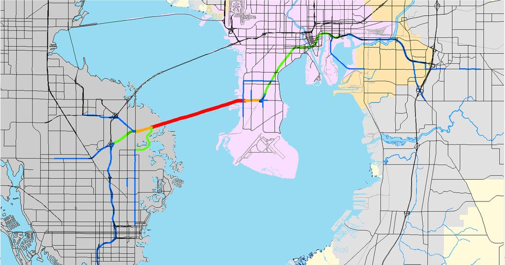


13 2035 Cost Affordable Plan without Gandy Elevated Lanes 13% 42% 13% 19% 12% 8% 19% 22%


14 2035 Cost Affordable Plan without Gandy Elevated Lanes 5% = 2,350 Daily Trips Drastic decrease in bridge traffic east of Selmon Expressway 25% take Selmon Expressway east of 22 nd Street 13% 12% 42% 8%
15 Existing and Future Volumes Segment 2006 Model Cost Affordable 2035 W/O Gandy Gandy Bridge 37,000 34,000 51,500 47,200 Gandy West of 46,000 43,000 37,700 55,900 Dale Mabry Gandy Elevated , Lanes Selmon 27,000 32,500 74,500 70,400 Expressway Westshore Blvd 16,000 15,000 15,500 19,000 north of Gandy Dale Mabry north of Gandy 29,800 35,500 38,200 33,500
16 What was Previously Considered?
17 Project Development & Environmental Study (early 1990s) Conducted by FDOT From 4 th St. (Pinellas) to Dale Mabry Hwy. Recommended: In Pinellas County: 6-lane controlled access road In Hillsborough: 4-lane controlled access road along CSX corridor south of Gandy Blvd. Not completed due to new Major Investment Study requirement
18 Major Investment Study ( ) Conducted by FDOT Many Alternatives considered Narrowed down to 3 options: 1. Elevated 4-lane controlled access road over Gandy Blvd. & re-construction of existing Blvd. as 4-lane divided road 2. At-grade 4-lane By-pass south of CSX rail line, plus enhancements to existing Gandy Blvd. 3. Widening Gandy to 6 lanes (insufficient capacity per FDOT traffic forecast) MPO endorsed moving ahead with options 1 & 2

19
20 PD&E Study Resumed ( ) Conducted by FDOT Alternatives Considered: Elevated 4-lane controlled access road over Gandy Blvd. 4-lane controlled access road along CSX right-of-way Tunnel (determined not viable due to cost) Dec. 2002: MPO motion to suspend study & enhance Gandy Blvd. instead
21 Gandy Area Transportation Study (2007) Conducted by City of Tampa Study area mostly south of Gandy Blvd. Assessed needs of pending new developments Recommended: Connecting Tyson Ave. from Westshore Blvd. to Manhattan Ave. Four-laning Westshore Blvd. from Tyson Ave. to Fair Oaks Ave. Adding a southbound lane on Manhattan Ave. from Gandy Blvd. to Tyson Ave. Other low-cost intersection and bicycle and pedestrian safety improvements.
22 Expressway Authority PD&E Study (2010) Conducted at request of City & FDOT Recommended 2-lane elevated toll way Elevated structure in median of Gandy Blvd. 30 foot height to allow visibility of businesses & landscaping State Environmental Impact Report prepared but not finalized by THEA
23 What Are Other Options I-275 Managed Lanes Water Taxi
24 I-275 Managed Lanes 2035 Traffic Volumes 58, , ,400 42,500
25 Existing and Future Volumes Segment Cost Affordable 2035 W/O Gandy 2035 I-275 Managed Gandy Bridge 34,000 51,500 47,200 42,500 Gandy West of 43,000 37,700 55,900 51,100 Dale Mabry Gandy Elevated -- 38, Lanes Selmon 32,500 74,500 70,400 34,500 Expressway Westshore Blvd 15,000 15,500 19,000 14,200 north of Gandy Dale Mabry north of Gandy 35,500 38,200 33,500 29,700
26 Public Investment Advantage HSF v. Roadways 2 x 250 Seat Ferries 750/peak 60 minutes; 1500 per peak 1 x 250, 1 x 500 Ferries 1250/peak 60 minutes; 2250 per peak 2 x 250, 1 x 500 Ferries 1500/peak 60 minutes, 2750 per peak. 1 Lane Interstate can carry 2,000 vehicles/hour. Adding one lane mile to major roadways = $20 million/mile. One lane mile addition for urban interstate = $50 to $100 million/mile.

27 Next Steps Textizen survey results next month
EXISTING PRIORITIES FUNDED FOR CONSTRUCTION LRTP
 EXISTING PRIORITIES FUNDED FOR CONSTRUCTION Limits Description Status 1 415489 3 H1865 US HWY 301 FROM SR 674 TO BALM RD Widen 2 lanes to 6 lanes divided County / Construction Programmed 2016 2 405492
REGIONAL PRIORITIES Presentation to the Tampa Bay Regional Collaboration Committee September 10, 2012
 WEST CENTRAL FLORIDA MPO CHAIRS COORDINATING COMMITTEE REGIONAL PRIORITIES Presentation to the Tampa Bay Regional Collaboration Committee September 10, 2012 TRANSPORTATION REGIONAL INCENTIVE PROGRAM (TRIP)
Reversible Elevated Express Lanes. A Solution for Urban Traffic Congestion
 Lee Roy Selmon Crosstown Expressway Reversible Elevated Express Lanes A Solution for Urban Traffic Congestion Martin Stone, Ph.D., AICP Director of Planning Tampa-Hillsborough Expressway Authority Pensacola
Turnpike Projects in Palm Beach County. Palm Beach TPA Update September 20, 2018
 Turnpike Projects in Palm Beach County Palm Beach TPA Update September 20, 2018 Agenda Background Funded Projects Future Project Status Widenings Interchanges Express Lanes Phasing 2 Background 45 Miles
Bay to Bay Boulevard Complete Streets Project
 Bay to Bay Boulevard Complete Streets Project Dale Mabry Highway to Bayshore Boulevard February 08, 2018 Photo Source: Tampa Bay Times Alessandra Da Pra Meeting Format Introduction Resurfacing Information
Creating the Future Bruce B Downs Blvd
 Creating the Future Bruce B Downs Blvd How things look today May not be how things look in the future. Bruce B Downs PD&E Study 2003 Construction programmed 2009, Palm Springs to Pebble Creek Tampa Rail
FINAL DESIGN TRAFFIC TECHNICAL MEMORANDUM
 FINAL DESIGN TRAFFIC TECHNICAL MEMORANDUM July 2014 FINAL (SR 43) Project Development and Environment Study From State Road 60 (Adamo Drive) to I-4 (SR 400) Hillsborough County, Florida Work Program Item
Congress Avenue. Palm Beach MPO Subcommittee Meetings December 2017
 1 Congress Avenue Palm Beach MPO Subcommittee Meetings December 2017 2 Agenda Study Purpose Study Process Multimodal Alternatives Development Next Steps *ACTION ITEM: CONFIRM ALTERNATIVES TO MOVE INTO
APPENDIX G: INTERSECTION NEEDS AT OKEECHOBEE BOULEVARD
 APPENDIX G: INTERSECTION NEEDS AT OKEECHOBEE BOULEVARD INTERSECTION NEEDS AT SR 7 and OKEECHOBEE BOULEVARD SR 7 Extension Project Development and Environment (PD&E) Study From Okeechobee Boulevard (SR
Hillsborough MPO List of Priority Projects 2016/2017 Transportation Improvement Program Table 1: EXISTING PRIORITIES FUNDED FOR CONSTRUCTION
 Hillsborough MPO List of s Table 1: EXISTING PRIORITIES FUNDED FOR CONSTRUCTION LRTP Number Limits Description Sponsor Status in /2016 TIP 415489 3 H1865 US HWY 301 FROM SR 674 TO BALM RD 405492 5 H300
State Road 54/56 Tampa Bay s Northern Loop. The Managed Lane Solution Linking I-75 to the Suncoast Parkway
 State Road 54/56 Tampa Bay s Northern Loop The Managed Lane Solution Linking I-75 to the Suncoast Parkway SUNCOAST PARKWAY Both I 75 and the Suncoast Parkway are planning, or in the process of constructing,
US 41 COMPLETE STREETS CORRIDOR PLANNING STUDY from University Parkway to Whitfield Avenue
 41 US 41 COMPLETE STREETS CORRIDOR PLANNING STUDY from University Parkway to Whitfield Avenue EXECUTIVE SUMMARY DRAFT FEBRUARY 2019 Project Overview The US 41 Complete Streets Corridor Planning Study,
Chapter 5 Future Transportation
 Chapter 5 Future Transportation The Future Land Use Plan identifies the desired land use designations. The land uses desired for Crozet depend, in large part, on the success of the transportation system,
APPENDIX L: COST ESTIMATING TOOLS
 APPENDIX L: COST ESTIMATING TOOLS Rural Arterial From LRE MOT * Mobilization * Subtotal Scope Contingency (25%) Total PE Design (15%) CEI (15%) Total Project ** New (2-Lane Roadway) with 5' Paved Shoulders
Financial Project ID No(s).: and ETDM No(s).: and 14181
.: and ETDM No(s).: and 14181") Palm Beach Metropolitan Planning Organization (MPO) Presentation I-95 at Boynton Beach Boulevard Interchange and I-95 at Gateway Boulevard Interchange Project Development and Environment Study Palm Beach
Palm Beach Metropolitan Planning Organization (MPO) Presentation I-95 at Boynton Beach Boulevard Interchange and I-95 at Gateway Boulevard Interchange Project Development and Environment Study Palm Beach
COWETA HIGH SCHOOL AND EAST HIGHWAY 51
 COWETA HIGH SCHOOL AND EAST HIGHWAY 51 Lack of sidewalks along Ben Lumpkin Rd. Lack of crosswalks and ramps at intersection. Hwy 51 is wide to cross as a pedestrian. No ADA compliance or connection to
BICYCLE/PEDESTRIAN ACCESS TO TRANSIT SAFETY ASSESSMENT FOR EXISTING AND PLANNED SECTIONS OF US 19
 BICYCLE/PEDESTRIAN ACCESS TO TRANSIT SAFETY ASSESSMENT FOR EXISTING AND PLANNED SECTIONS OF US 19 Project Advisory Committee Meeting December 2, 2015 A JOINT EFFORT OF THE PINELLAS METROPOLITAN PLANNING
Planning Study SR 976. Project Advisory Team Meeting May 24, 2017
 ` SR 976 BIRD ROAD/SW 40TH STREET FROM SR 821/HEFT TO SR 5/US-1 Miami-Dade County, Florida FPID No.: 434845-4-22-01 Planning Study Project Advisory Team Meeting May 24, 2017 1 Agenda Introductions Project
Transportation Investment Act Gwinnett County. Charlotte J. Nash, Chairman Gwinnett County Board of Commissioners
 Transportation Investment Act Gwinnett County Charlotte J. Nash, Chairman Gwinnett County Board of Commissioners April 25, 2012 Transportation Investment Act Gwinnett County Gwinnett County Transportation
Route 7 Corridor Study
 Route 7 Corridor Study Executive Summary Study Area The following report analyzes a segment of the Virginia State Route 7 corridor. The corridor study area, spanning over 5 miles in length, is a multi
Route 29 Solutions Projects
 Route 29 Solutions Route 29 Solutions Projects www.route29solutions.org October 10, 2014 Route 29 Widening to Six Lanes Albemarle County This project will widen a 1.8-mile segment of Route 29 from four
FINAL REPORT - Revised from original submittal -
 FINAL REPORT - Revised from original submittal - Comparing Street Lighting Levels with Nighttime Crash Histories -VOLUME I- Submitted to: Florida Department of Transportation District 7 11201 N Malcolm
CITY OF SPOKANE VALLEY Request for Council Action
 CITY OF SPOKANE VALLEY Request for Council Action Meeting Date: December 16, 2014 Department Director Approval: Check all that apply: consent old business new business public hearing information admin.
Foothill Expressway Improvements Between El Monte and San Antonio
 Foothill Expressway Improvements Between El Monte and San Antonio June 29, 2017 - Los Altos Community Meeting Introduction Project Background Agenda Visit Stations: Provide Input and Ask Questions Reconvene:
2035 Plan Post-Referendum Analysis
 2035 Plan Post-Referendum Analysis June 14, 2011 Prepared For: 601 East Kennedy Boulevard Tampa, FL 33602 www.hillsboroughmpo.org Prepared By: Introduction For this memorandum, research on cost reduction
JONESBORO HIGHWAY 63 HIGHWAY 18 CONNECTOR STUDY
 JONESBORO HIGHWAY 63 HIGHWAY 18 CONNECTOR STUDY Craighead County May 2007 JONESBORO HIGHWAY 63 HIGHWAY 18 CONNECTOR STUDY Craighead County May 2007 Prepared by Planning and Research Division Arkansas State
STREET AND HIGHWAY PLAN
 STREET AND HIGHWAY PLAN Introduction The street and highway system in the Winston-Salem Urban Area consists of thousands of miles of traffic carrying facilities, ranging from short local residential streets
Santa Clara I-280 CORRIDOR STUDY
 Santa Clara I-280 CORRIDOR STUDY OCTOBER 2017 PREPARED BY: 1.1 Background The I-280 Corridor Study within Santa Clara County is a high-level highway planning study led by the Santa Clara VTA, in partnership
SR 826/PALMETTO EXPRESSWAY EXPRESS LANES PD&E STUDY From US 1/SR 5/Dixie Highway to SR 836/Dolphin Expressway FPID No.: ETDM No.
 SR 826/PALMETTO EXPRESSWAY EXPRESS LANES PD&E STUDY From US 1/SR 5/Dixie Highway to SR 836/Dolphin Expressway FPID No.: 432639-1-22-02 ETDM No.: 14308 Newsletter 3 - March 2019 Incluye versión en español
2012 PRIORITY TRANSPORTATION PROJECTS
 0 PRIORITY TRANSPORTATION PROJECTS The 0 Priority Transportation Projects include candidate road, congestion management, multi-use trail, transit, transportation regional incentive program (TRIP), county
Project Description Form 8EE
 Project Description Form 8EE Basic Project Information Submitting Jurisdiction/Agency: Town of Dumfries Project Title: Route 1 (Fraley Blvd) Widening: Brady's Hill Road to Dumfries Road Project Location:
Description: Widen I-64 to 6 lanes from I-265 to the KY 53 interchange in Shelby County.
 I-64 KIPDA ID # 350 Project Type: ROADWAY CAPACITY Description: Widen I-64 to 6 lanes from I-265 to the KY 53 interchange in Shelby County. Purpose: Project will improve capacity and address safety concerns.
Central Avenue Corridor Study FPID Number:
 Central Avenue Corridor Study FPID Number: 437932-1-18-01 City Commission Presentation 1 March 27, 2018 Meeting Agenda 1. Introductions 2. Project Overview 3. Opportunity for Economic Development 4. Healthy
SR 693 (Pasadena Avenue) Corridor Study from Shore Drive South to 66 th Street
 Corridor Study from Shore Drive South to 66 th Street") Welcome and Introduction Sign-in and comment sheets Restrooms and exits Meeting agenda and timeline Meeting goals / expectations Provide input to guide study recommendations Actively participate throughout
Welcome and Introduction Sign-in and comment sheets Restrooms and exits Meeting agenda and timeline Meeting goals / expectations Provide input to guide study recommendations Actively participate throughout
US 19 PEDESTRIAN AND BICYCLE SAFE ACCESS
 US 19 PEDESTRIAN AND BICYCLE SAFE ACCESS TO TRANSIT CORRIDOR STUDY A JOINT EFFORT OF THE FLORIDA DEPARTMENT OF TRANSPORTATION AND FORWARD PINELLAS (F.K.A. PINELLAS COUNTY METROPOLITAN PLANNING ORGANIZATION)
Alternatives Public Workshop
 US 1 Express Lanes Project Development & Environment (PD&E) Study Alternatives Public Workshop August 2013 1 Today s Agenda Project Background and Overview Tier 1 Alternatives Development Tier 2 Decision-Making
Bluffdale South (SR140) Bicycle/Shoulder Lanes Project Type Bicycle
 Bicycle/Shoulder Lanes Project Type Bicycle") Bluffdale 14600 South (SR140) Bicycle/Shoulder Lanes Project Type Bicycle From Pony Express to UPRR Bridge over SR-140 $ 669,700 $ 624,361 To build bicycle/shoulder lanes on SR-140. SR-140 is an official
Bluffdale 14600 South (SR140) Bicycle/Shoulder Lanes Project Type Bicycle From Pony Express to UPRR Bridge over SR-140 $ 669,700 $ 624,361 To build bicycle/shoulder lanes on SR-140. SR-140 is an official
Hillsborough County 2035 Long Range Transportation Plan
 Hillsborough County 2035 Long Range Transportation Plan Adopted December 9, 2009 AMENDED August 3, 2010 MODIFIED September 1, 2010 AMENDED January 4, 2011 Hillsborough County Metropolitan Planning Organization
Pinellas County Metropolitan Planning Organization (MPO) 2014 Crash Data Report
 2014 Crash Data Report") Pinellas County Metropolitan Planning Organization (MPO) 2014 Crash Data Report MPO Board July 8, 2015 2 Crash Data Collection Motorcycle drove between stopped cars, ran a red light and collided with a
Pinellas County Metropolitan Planning Organization (MPO) 2014 Crash Data Report MPO Board July 8, 2015 2 Crash Data Collection Motorcycle drove between stopped cars, ran a red light and collided with a
Dr. M.L. King, Jr. Street North Complete Streets Resurfacing Opportunities HOUSING, LAND USE, AND TRANSPORTATION COMMITTEE MARCH 22, 2018
 Dr. M.L. King, Jr. Street North Complete Streets Resurfacing Opportunities HOUSING, LAND USE, AND TRANSPORTATION COMMITTEE MARCH 22, 2018 What s Happening The City plans to mill and resurface Dr. M.L.
TAMPA BAY EXPRESS (TBX)
") TAMPA BAY EXPRESS (TBX) Hank Schneider, P.E. FDOT- District 7 Consultant Project Manager Florida Department of TRANSPORTATION TAMPA BAY EXPRESS AGENDA What is TBX? What does TBX do? Why is TBX Important?
TAMPA BAY EXPRESS (TBX) Hank Schneider, P.E. FDOT- District 7 Consultant Project Manager Florida Department of TRANSPORTATION TAMPA BAY EXPRESS AGENDA What is TBX? What does TBX do? Why is TBX Important?
Hillsborough MPO List of Priority Projects 2018/2019 Transportation Improvement Program Table 1: EXISTING PRIORITIES FUNDED FOR CONSTRUCTION
 MPO List of s 2018/2019 Transportation Improvement Program Table 1: EXISTING PRIORITIES FUNDED FOR CONSTRUCTION Number Limits Sponsor Status in 2017/2018 TIP 415489 3 101 US 301 from SR 674 to Balm Rd
Los Altos Hills Town Council - June 18, 2015 Palo Alto City Council June 22, AGENDA ITEM #2.B Presentation
 Los Altos Hills Town Council - June 18, 2015 Palo Alto City Council June 22, 2015 AGENDA ITEM #2.B Presentation Previous Presentations Los Altos Hills Town Council in May 2014 and February 2015 Palo Alto
C C C
 C-012-001 Thank you for your support for the creation of new public space and nonmotorized access between downtown and the waterfront through the Overlook Walk, the East-West Connections, and the Promenade.
Performance Criteria for 2035 Long Range Transportation Plan
 Minimizing Impacts on Natural, Historic, Cultural or Archeological Resources 2035 LRTP Weighting Factor: 7% Objective 1.1: Use appropriate planning and design criteria to protect and enhance the built
Initial Alternatives Identification and Evaluation Report. November 2011 APPENDIX B. Summary of Stakeholder Single Mode Suggestions
 Initial Alternatives Identification and Evaluation Report ovember 2011 APPEDIX B Summary of Stakeholder Single Mode Suggestions 2011 Illinois Department of Transportation Summary of Stakeholder Alternatives
US HIGHWAY 19 CORRIDOR CONDITIONS, TRENDS, PLANNING ACTIVITIES. Pinellas County Metropolitan Planning Organization
 US HIGHWAY 19 CORRIDOR CONDITIONS, TRENDS, PLANNING ACTIVITIES Pinellas County Metropolitan Planning Organization September 9, 9 2015 US Highway 19 Conditions, i Trends, Planning Activities i i Traffic
Northbound San Jose Avenue & I-280 Off-Ramp Road Diet Pilot Project
 Project Overview Fed by a two-lane Interstate-280 (I-280) off-ramp, high vehicular volumes and speeds are longstanding issues along San Jose Avenue. Residents in the surrounding neighborhoods have expressed
DRAFT. Memo. Range of the Alternatives Considered in the EIS
 Memo Date: Friday, December 09, 2016 Project: To: From: Subject: State Route 30 EIS UDOT Vince Izzo This memorandum summarizes the draft State Route (S.R.) 30 Level 1 screening results. A more detailed
Safety Emphasis Areas & Safety Project Development Florida Department of Transportation District Seven Tampa Bay
 Safety Emphasis Areas & Safety Project Development Florida Department of Transportation District Seven Tampa Bay Stephen L. Benson, AICP, CNU-A FDOT District Seven Safety Office Presentation Overview Safety
Presentation Outline. PD&E Study Process Project Overview Proposed Alternatives & Evaluation Schedule Contact Information
 Volusia Transportation Planning Organization CAC / TCC Project Update Tuesday, May 21, 2013 1 Presentation Outline PD&E Study Process Project Overview Proposed Alternatives & Evaluation Schedule Contact
County of Fairfax, Virginia. Department of Transportation
 Fairfax County Parkway History 2 Planning began 50 years ago 1960s Washington s Regional Transportation Plan Recommends improved north/south travel Construct Capital Beltway and outer beltway Outer beltway
Staunton. Transportation Plan. Transportation Planning Division. Virginia Department of Transportation
 2020 Transportation Plan Developed for the Transportation Planning Division of the Virginia Department of Transportation in cooperation with the U.S. Department of Transportation, Federal Highway Administration
Project Fact Sheet. August 1,
 Fact Sheet City of Gainesville Transportation Master Plan In December 2012, the Mayor and City Council selected a consultant team of Pond & Company and Arcadis to prepare the City of Gainesville Transportation
Highway 49, Highway 351 and Highway 91 Improvements Feasibility Study Craighead County
 Highway 49, Highway 351 and Highway 91 Improvements Feasibility Study Craighead County Executive Summary March 2015 Highway 49, Highway 351 and Highway 91 Improvements Feasibility Study Craighead County
MoPac South: Impact on Cesar Chavez Street and the Downtown Network
 MoPac South: Impact on Cesar Chavez Street and the Downtown Network Prepared by: The University of Texas at Austin Center for Transportation Research Prepared for: Central Texas Regional Mobility Authority
Why is Access Management. Important? Can Improve Safety by Reducing Conflicts. Fewer conflicts means fewer crashes
 Why is Access Management 16 Important? Can Improve Safety by Reducing Conflicts Fewer conflicts means fewer crashes Driving Down Fatalities Through Knowledge Sharing FDOT References 16 Access Management/
FLORIDA DEPARTMENT OF TRANSPORTATION DISTRICT 7 DISTRICT WIDE BICYCLE/PEDESTRIAN ACCESS TO TRANSIT SAFETY ASSESSMENT AND IMPROVEMENT PLAN
 FLORIDA DEPARTMENT OF TRANSPORTATION DISTRICT 7 DISTRICT WIDE BICYCLE/PEDESTRIAN ACCESS TO TRANSIT SAFETY ASSESSMENT AND IMPROVEMENT PLAN TRANSIT SAFETY ASSESSMENT SR 55/US 19 AT 80 TH AVE N DRAFT JUNE
City of Wilsonville 5 th Street to Kinsman Road Extension Project
 City of Wilsonville 5 th Street to Kinsman Road Walking Tour & Neighborhood Workshop Summary Report Public Outreach Overview On July 18 th, 2017, the City of Wilsonville hosted a neighborhood walking tour
A Federal Perspective on Congestion Pricing. Wayne Berman Federal Highway Administration July 8, 2010
 A Federal Perspective on Congestion Pricing Wayne Berman Federal Highway Administration July 8, 2010 Overview Background on Congestion Pricing Benefits and Experiences of Pricing Case Study Miami I-95
El Camino Real Specific Plan. TAC/CAC Meeting #2 Aug 1, 2018
 El Camino Real Specific Plan TAC/CAC Meeting #2 Aug 1, 2018 Land Use Alternatives Goals and Tradeoffs Parks & open space Housing Retail & services Civic spaces Parking Community gathering spaces 3 Alternatives
EXECUTIVE SUMMARY... vii 1 STUDY OVERVIEW Study Scope Study Area Study Objectives
 Contents EXECUTIVE SUMMARY... vii 1 STUDY OVERVIEW... 1-1 1.1 Study Scope... 1-1 1.2 Study Area... 1-1 1.3 Study Objectives... 1-3 2 EXISTING CONDITIONS... 2-1 2.1 Existing Freeway Conditions... 2-4 2.1.1
US 19 Pedestrian and Bicycle Safe Access to Transit Corridor Study
 US 19 Pedestrian and Bicycle Safe Access to Transit Corridor Study Summary Report October 2016 Prepared for: FLORIDA DEPARTMENT OF TRANSPORTATION DISTRICT 7 (FDOT) Contract No: C 9B41, FAP No: 8886 318
3.0 Future Conditions
 3.0 Future Conditions In order to be able to recommend appropriate improvements to the transportation system of the Town, it is important to first understand the nature and volume of traffic that is expected
Rideau Canal Corridor Pedestrian Crossing Study. Queen Elizabeth Dr.: Preston St. to Laurier Ave. & Colonel By Drive: Hog s Back to Daly Ave.
 Rideau Canal Corridor Pedestrian Crossing Study Queen Elizabeth Dr.: Preston St. to Laurier Ave. & Colonel By Drive: Hog s Back to Daly Ave. Background: Canal parkways evolved over past 100 years Today
Sarasota/Manatee MPO Project Priorities 2016 Adopted April 25, 2016
 All projects on the following priority lists should be implemented in the priority sequence listed, as consistent with the fiscal constraints identified in the MPO s adopted Long Range Transportation Plan
Welcome to Laredo Metropolitan Transportation Plan First Public Meeting. February 27 th, :30 PM to 7:30 PM. We value your opinion!
 Welcome to Laredo 2015-2040 Metropolitan Transportation Plan First Public Meeting February 27 th, 2014-5:30 PM to 7:30 PM We value your opinion! Todays Objectives Initiate the planning exercise for the
Terwillegar Drive Expressway Draft Concept Plan
 Terwillegar Drive Expressway Draft Concept Plan Anthony Henday Drive to Whitemud Drive November 28 5:00-8:00 p.m. December 1 10:00 a.m. - 3:00 p.m. Let s Talk Today you can: Learn about the new direction
US 19 Pedestrian and Bicycle Safe Access to Transit Corridor Study
 US 19 Pedestrian and Bicycle Safe Access to Transit Corridor Study DRAFT Technical Memorandum #6 Cost and Benefit Evaluation Methodology August 2016 Prepared for: FLORIDA DEPARTMENT OF TRANSPORTATION DISTRICT
Comprehensive Collection of Stakeholder Alternatives by Mode
 2011 Illinois Department of Transportation Comprehensive Collection of Stakeholder Alternatives by Mode October 2009 January 2011 www.dot.il.gov www.eisenhowerexpressway.com FILEY RD FILEY RD IHB RR 2
West Shore Boulevard Complete Street Feasibility Evaluation. Summary Report. Prepared for: City of Tampa, Florida. Prepared by: May 8, 2014
 West Shore Boulevard Complete Street Feasibility Evaluation Summary Report Prepared for: City of Tampa, Florida Prepared by: May 8, 2014 ADEAS-Q Page 2 EXECUTIVE SUMMARY A complete-street feasibility evaluation
Modal Interrelationships: A bicycle lane is proposed between Harrington Ave and Swanns Station Rd.
 DRAFT PROJECT PAGE July 12, 2007 Main St / Broadway Rd (SR 1579) Project Statement Project Recommendation: From Avent Ferry Rd (NC 42) to the Harnett County line, Broadway Rd/Main St is recommended to
ROADSOADS CONGESTION HAMPTON SYSTEMYSTEM MANAGEMENT. Part II Roadway Congestion Analysis Mitigation Strategies and Evaluation
 HAMPTON ROADSOADS CONGESTION MANAGEMENT SYSTEMYSTEM Part II Roadway Congestion Analysis Mitigation Strategies and Evaluation Presented by: Dwight Farmer, PE Deputy Executive Director, Transportation April
Harrah s Station Square Casino
 Transportation Analysis Harrah s Station Square Casino Pittsburgh, Pennsylvania Submitted To: City of Pittsburgh and Pennsylvania Gaming Control Board Prepared By: DKS Associates GAI Consultants December
PUBLIC REALM MASTER PLAN
 WESTSHORE BUSINESS DISTRICT PUBLIC REALM MASTER PLAN MASTER PLAN COMMITTEE MEETING MARCH 20, 2013 WESTSHORE BUSINESS DISTRCT PUBLIC REALM MASTER PLAN MACRO-SCALE CONCEPT: A PUBLIC REALM FRAMEWORK DEFINED
Dr. Naveed Anwar Executive Director, AIT Consulting Affiliated Faculty, Structural Engineering Director, ACECOMS
 Dr. Naveed Anwar Executive Director, AIT Consulting Affiliated Faculty, Structural Engineering Director, ACECOMS Overview Highway Functions and Classifications Highway Design Components Design Control
City of Gainesville Transportation/Roadway Needs PROJECT SUMMARY
 A1 Roadway Resurfacing $23,846,000 TYPE: Preservation of existing system Roadway resurfacing A2 Signal Replacement $6,000,000 TYPE: Preservation of existing system Replace traffic signals. B1 W 6th St
Feasibility Study of Pedestrian Crossings Along Route 7, East of Cascades Parkway and West of Dranesville Road. October 3, 2017
 Feasibility Study of Pedestrian Crossings Along Route 7, East of Cascades Parkway and West of Dranesville Road October 3, 2017 Study Area (area within a ¼-mile radius of the study intersections) Route
Today s Agenda. Welcome & Introductions. I-526 Lowcountry Corridor Update. Table Discussions. Next Steps / Conclusion
 SCDOT Turns 100! SCDOT Turns 100! Today s Agenda Welcome & Introductions I-526 Lowcountry Corridor Update Table Discussions Next Steps / Conclusion Project Limits I-526 Lowcountry Corridor Project Description
Model Applications for Oakland Park Boulevard Transit Corridor Study
 Model Applications for Oakland Park Boulevard Transit Corridor Study Southeast Florida FSUTMS Users Group June 13, 2014 Vikas Jain, AICP, GISP FDOT District Four Auditorium 3400 West Commercial Boulevard,
Appendix C. NORTH METRO STATION AREA TRAFFIC IMPACT STATEMENT 88th Avenue Station
 Appendix C NORTH METRO STATION AREA TRAFFIC IMPACT STATEMENT 88th Avenue Station Prepared for: Regional Transportation Department and URS Corporation as part of the North Metro EIS David Evans and Associates,
CITY OF COCOA BEACH 2025 COMPREHENSIVE PLAN. Section VIII Mobility Element Goals, Objectives, and Policies
 CITY OF COCOA BEACH 2025 COMPREHENSIVE PLAN Section VIII Mobility Element Goals, Objectives, and Policies Adopted August 6, 2015 by Ordinance No. 1591 VIII MOBILITY ELEMENT Table of Contents Page Number
Transportation Planning Division
 Transportation Planning Division Presentation Outline Study Tasks Recap of Previous Meetings Data Collected Focus Areas within Study Limits Design Principles Tool Box Recommended Concepts Schedule Moving
Public Involvement Kickoff Meeting. April 29, 2015
 Public Involvement Kickoff Meeting April 29, 2015 Title VI Compliance The Florida Department of Transportation complies with various non-discrimination laws and regulations, including Title VI of the Civil
Twin Cities Bicycle Barriers Study Technical Advisory Work Group December 19, 2016
 Twin Cities Bicycle Barriers Study Technical Advisory Work Group December 19, 2016 Regional Bicycle Barriers Overall Study Area Parameters Specific Barrier Parameters Rivers & streams Rail corridors Overall
KEARNY MESA COMMUNITY PLAN UPDATE
 KEARNY MESA COMMUNITY PLAN UPDATE January 18, 2018 SUBCOMMITTEE MEETING Mobility Concepts and Urban Design Presentation Outline Mobility Concepts: Multimodal Planning Toolbox Presentation and Activities
Introduction. Project Need
 Introduction The purpose of Subtask 1 of the SR 54/56 Project Concept Development (PCD) Study is to identify and summarize the goals and proposed operations for transit corridor improvements as depicted
DES MOINES AREA MPO. Presentation to Iowa Commercial Real Estate Association. April 6, 2017
 DES MOINES AREA MPO Presentation to Iowa Commercial Real Estate Association April 6, 2017 Presentation Outline MPO Overview Trends We re Watching Plans, Projects, Initiatives, Regional Transportation Priorities
BETHEL ROAD AND SEDGWICK ROAD CORRIDOR STUDY
 DRAFT PLAN City Council Meeting August 14, 2017 STUDY AREA Sedgwick Corridor State Route 160, principal arterial with Class 3 access management designation, commuter and freight route, connection to SR
MPO Staff Report Technical Advisory Committee: May 10, 2017 MPO Executive Board: May 17, 2017
 MPO Staff Report Technical Advisory Committee: May 10, 2017 MPO Executive Board: May 17, 2017 RECOMMENDED ACTION: Update on the NDDOT US Business 2 Project Programmed for 2019 Matter of the NDDOT US Business
STUDY PROCESS & SCHEDULE
 STUDY PROCESS & SCHEDULE Route Centennial Bridge Study KDOT Project No. -52 KA-3229-01 STUDY OVERVIEW STUDY SCHEDULE The Kansas Department of Transportation (KDOT) has identified a future need to replace
MULTIMODAL NEEDS ASSESSMENT
 5. PORTS OF ENTRY INTRODUCTION The El Paso MPO region is one of the most significant border crossing regions in the United States. Known as the world s largest international border metroplex, traffic and
SECTION 2 ALTERNATIVES INCLUDING PROPOSED ACTION 2.0 ALTERNATIVES INCLUDING PROPOSED ACTION 2.1 INTRODUCTION 2.2 ALTERNATIVES CONSIDERED BUT REJECTED
 2.0 ALTERNATIVES INCLUDING PROPOSED ACTION 2.1 INTRODUCTION The City of Starke is currently a bottleneck for traffic traveling along U.S. 301 in Bradford County. Local urban traffic combined with increasing
Environmental Assessment Findings & Recommendations. Public Hearing November 13, 2014
 Environmental Assessment Findings & Recommendations Public Hearing November 13, 2014 Welcome! Welcome and Introductions Project and Environmental Assessment Overview Public Comments Adjourn Purpose of
ISSUE 1. Geography challenge. Geography funnels traffic from several key corridors onto I-5.
 ISSUE 1 Geography challenge Geography funnels traffic from several key corridors onto I-. ISSUE 2 Less redundancy Northern OC has a dense network of roadways for traffic to shift to during unexpected incidents.
BICYCLE/PEDESTRIAN ACCESS TO TRANSIT SAFETY ASSESSMENT FOR EXISTING AND PLANNED SECTIONS OF US 19
 BICYCLE/PEDESTRIAN ACCESS TO TRANSIT SAFETY ASSESSMENT FOR EXISTING AND PLANNED SECTIONS OF US 19 Project Advisory Committee Meeting January 27, 2016 A JOINT EFFORT OF THE PINELLAS METROPOLITAN PLANNING
HILLSBOROUGH COUNTY BICYCLE & PEDESTRIAN COUNTS
 Hillsborough County Metropolitan Planning Organization 61 E. Kennedy, 18th Floor Tampa, Florida 3361 111 813/272 594 FAX NO. 813/31 7172 HILLSBOROUGH COUNTY BICYCLE & PEDESTRIAN COUNTS 2 & 25 TABLE OF
University Hill Transportation Study Technical Memorandum Alternatives Modeling and Analysis May 2007
 Technical Memorandum May 2007 Syracuse Metropolitan Transportation Council Edwards and Kelcey with Wallace Roberts and Todd Alta Planning and Design CONTENTS SECTION ONE- INTRODUCTION...1 SECTION TWO-
Corridor Advisory Group and Task Force Meeting #10. July 27, 2011
 Corridor Advisory Group and Task Force Meeting #10 July 27, 2011 1 Agenda Recap CAG/TF #9 Public Meeting #2 Summary Single Mode Alternatives Evaluation Results Next Steps 2 3 CAG/TF #9 Recap CAG /TF #9
Legislative Update. Frederick County Fall Staunton District. Interstate 81 - Exit 300 at Interstate 66 Southbound Acceleration Lane Extension
 Interstate 81 - Exit 300 at Interstate 66 Southbound Acceleration Lane Extension Application ID 1643 Northern Shenandoah Valley Regional Commission (NSVRC) $3,437,423 This project extends the Interstate