Why is Access Management. Important? Can Improve Safety by Reducing Conflicts. Fewer conflicts means fewer crashes
|
|
|
- Dulcie Phillips
- 5 years ago
- Views:
Transcription
1 Why is Access Management 16 Important? Can Improve Safety by Reducing Conflicts Fewer conflicts means fewer crashes Driving Down Fatalities Through Knowledge Sharing
 Driveway Information Guide (8) http://www.dot.state.fl.us/planning/ systems/programs/sm/accman/default.")
2 FDOT References 16 Access Management/ Systems Planning Office FAC 14 96, State Highway System Connection Permit FAC 14 97, State Highway System Access Control Class. System and Access Management Standards The Median Handbook (14) Driveway Information Guide (8) systems/programs/sm/accman/default.shtm Driving Down Fatalities Through Knowledge Sharing


3 Fewer conflicts means fewer crashes 4 way Intersection T Intersection 16 4 way Intersection Bi Directional Median Opening T Intersection Directional Median Opening Driving Down Fatalities Through Knowledge Sharing


4 Medians Improve Safety 16 Fewer conflicts Simplifies driving tasks Pedestrian refuge Driving Down Fatalities Through Knowledge Sharing


5 Traffic Spillback 16 Driving Down Fatalities Through Knowledge Sharing


6 Crowded Opening 16 Driving Down Fatalities Through Knowledge Sharing

7 Lack of Storage 16 Driving Down Fatalities Through Knowledge Sharing

8 STATE ROAD 6 (KENNEDY BOULEVARD) ACCESS MANAGEMENT SAFETY STUDY From Westshore Boulevard to N. Brevard Avenue Hillsborough County, Florida SUBMITTED TO FLORIDA DEPARTMENT OF TRANSPORTATION DISTRICT 7 Contract Number C-9A41 Financial Project Number: Task Work Order 3 FINAL REPORT August 15
 - Unsignalized Directional Median Opening - (%) Segment Two 1.")


 - Unsignalized - 15 (63%) -")


9 NOT TO SCALE SEGMENT TWO MEDIAN OPENING LEGEND - Signalized Intersection - 5 (19%) - Unsignalized - (81%) - Unsignalized Directional Median Opening - (%) Segment Two 1.6 MILES Brevard Ave Fielding Ave Boulevard N Edison Ave S Edison Ave N Deleware Ave S Deleware Ave Newport Ave Willow Ave Orleans Ave Oregon Ave Dakota Ave Rome Ave Packwood Ave Freemont Ave Melville Ave Albany Ave Westland Ave Howard Ave Moody Ave Armenia Ave Figure -1 KENNEDY BOULEVARD STUDY AREA Tampania Ave 1.58 City of Tampa Arrawana Ave Habana Ave Bungalow Park Ave Gomez Ave New Jersey Ave MacDill Ave Woodlynne Ave Henderson Blvd Bradford Ave Lincoln Ave Beverly Ave Glen Ave Kennedy Boulevard Corridor 3.5 Miles Himes Ave.999 Sterling Ave.874 SEGMENT ONE MEDIAN OPENING LEGEND - Signalized Intersection - 6 (5%) - Unsignalized - 15 (63%) - Unsignalized Directional Median Opening - 3 (1%) Segment One 1.88 MILES Dale Mabry Hwy Church Ave Grady Ave Hale Ave Clark Ave Krental Ave Lois Ave Hubert Ave Manhattan Ave Lauber Way Hesperides St Cooper Pl Trask St Renelle Dr Westshore Blvd Miles 17 Median Openings KENNEDY BOULEVARD CORRIDOR LEGEND - Signalized Intersection - 11 Total (%) - Unsignalized - 37 Total (73%) - Unsignalized Directional Median Opening - 3 Total (6%)
10 PEDESTRIAN / BICYCLE SAFETY ASSESSMENT Westshore Himes 1 13 Travel Incapacitating Injury Crash Summary / Injury Severity Non Incapacitating Injury Possible Injury No Injury TOTAL Mode Fatal Pedestrian Bicycle 1 3 TOTAL Table 3 7: Pedestrian / Bicycle 4 Year Crash Summary / Injury Severity Crash Summary / Lighting Condition Travel Mode Daytime Night with Street Lights Night W/O Street Lights TOTAL Pedestrian Bicycle 1 3 TOTAL Table 3 8: Pedestrian / Bicycle 4 Year Crash Summary / Lighting Condition In X Walk Signalized Crash Summary / Crosswalk In X Walk Unsignalized Not in X walk Travel Mode TOTAL Pedestrian Bicycle 1 3 TOTAL Table 3 9: Pedestrian / Bicycle 4 Year Crash Summary / Crosswalk Related State Road 6 (Kennedy Boulevard) 18 Access Management Safety Study


11 C-
12 Median Four-Year Crash Experience (1-13) Median Opening Type (Full, Directional, Total Total Ped/Bike Four Year Crash Criterion (1 13) Total Collisions Total Collisions Total Correctable Collisions (Left Turn / Right Total Correctable Collisions Total Correctable Collisions ID Intersection Signal) M.P. Collisions Collisions With Injury With Fatal Angle) With Injury With Fatal 1 A Westshore Boulevard Signalized B S Renelle Drive Full C Trask Street Full D Cooper Place Full E Hesperides Street Full F Lauber Way W/B In E/B Out G Manhattan Avenue Full H Hubert Avenue Full I Lois Avenue Signalized J Krental Avenue Full K Clark Avenue Full L Hale Avenue Full M Grady Avenue Full N Church Avenue E/B Directional O Dale Mabry Highway Signalized P Sterling Avenue Full Q Himes Avenue Signalized R Glen Avenue Full S Beverly Avenue Full T Lincoln Avenue Full U Bradford Avenue Full V Henderson Boulevard Signalized W Woodlynne Avenue Full X MacDill Avenue Signalized


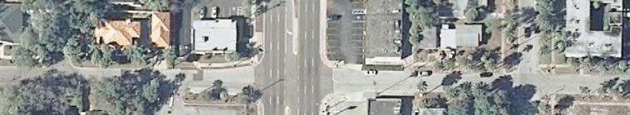
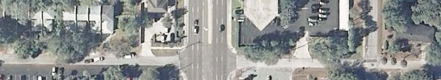
13 Kennedy Boulevard (SR 6) Access Management Safety Study Hillsborough County, Florida LOCATION ID: Median Opening 1-A MILEPOST: 1.68 CONDITION DIAGRAM CROSS STREET: Westshore Blvd. W N E Bank of America 56 3 Walgreens S 3 Kennedy Blvd. 5 TURN LANES STORAGE LENGTH (FT) APPROACH RIGHT LEFT STORAGE TAPER STORAGE TAPER SB NB EB WB Urban Plaza Business Center Westshore Blvd Chevron Town Square Plaza COLLISION DIAGRAM AM Peak Hour X X Mid-Day Peak Hour PM Peak Hour COLLISION SYMBOLS RIGHT ANGLE COLLISION LEFT TURN COLLISION OUT OF CONTROL SIDE SWIPE HEAD-ON COLLISION REAR END COLLISION FATAL CRASH INJURY CRASH COLLISION TYPE NUMBER OF COLLISIONS COLLISION COLLISION SEVERITY TOTALS LEFT-TURN / ANGLE SUMMARY TOTALS PDO INJURY FATALITY 4-YR TOTAL AVG / YEAR INJ / FATAL LEFT-TURN ANGLE PEDESTRIAN / BICYCLE 1 1 OTHER COLLISION TOTALS X BIKE PEDESTRIAN A-1


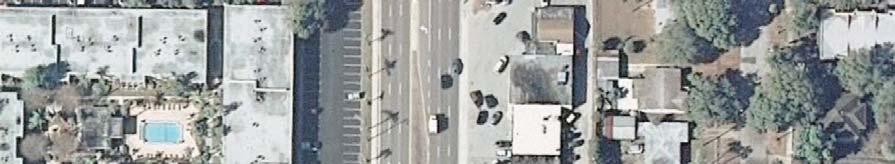
14 Kennedy Boulevard (SR 6) Access Management Safety Study Hillsborough County, Florida LOCATION ID: Median Opening 1-K MILEPOST:.359 CONDITION DIAGRAM CROSS STREET: Clark Ave. 7 Jimbo s Pit Bar B-Q 4 Uniform City 4 Kennedy Blvd TURN LANES STORAGE LENGTH {FT} APPROACH RIGHT LEFT STORAGE TAPER STORAGE TAPER SB NB EB WB TransWorld Center 36 Clark Ave Business Plaza W N S E COLLISION DIAGRAM AM Peak Hour Mid-Day Peak Hour PM Peak Hour COLLISION SYMBOLS RIGHT ANGLE COLLISION LEFT TURN COLLISION OUT OF CONTROL SIDE SWIPE HEAD-ON COLLISION REAR END COLLISION FATAL CRASH INJURY CRASH COLLISION TYPE NUMBER OF COLLISIONS COLLISION COLLISION SEVERITY TOTALS LEFT-TURN / ANGLE SUMMARY TOTALS PDO INJURY FATALITY 4-YR TOTAL AVG / YEAR INJ / FATAL LEFT-TURN ANGLE PEDESTRIAN / BICYCLE OTHER COLLISION TOTALS X BIKE PEDESTRIAN A-1


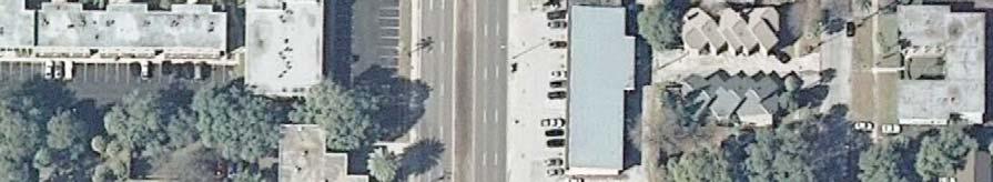
15 Kennedy Boulevard (SR 6) Access Management Safety Study Hillsborough County, Florida LOCATION ID: Median Opening 1-L MILEPOST:.4 CONDITION DIAGRAM CROSS STREET: Hale Ave. W N S E Medi Weight Loss Plaza 4 Hale Ave. 8 8 Radio Shack Plaza 6 Kennedy Blvd TURN LANES STORAGE LENGTH {FT} APPROACH RIGHT LEFT STORAGE TAPER STORAGE TAPER SB NB EB 65 9 Business Plaza 9 3 Retail Plaza 6 WB 65 1 COLLISION DIAGRAM AM Peak Hour Mid-Day Peak Hour PM Peak Hour COLLISION SYMBOLS RIGHT ANGLE COLLISION LEFT TURN COLLISION OUT OF CONTROL SIDE SWIPE HEAD-ON COLLISION REAR END COLLISION FATAL CRASH INJURY CRASH COLLISION TYPE NUMBER OF COLLISIONS COLLISION COLLISION SEVERITY TOTALS LEFT-TURN / ANGLE SUMMARY TOTALS PDO INJURY FATALITY 4-YR TOTAL AVG / YEAR INJ / FATAL LEFT-TURN ANGLE PEDESTRIAN / BICYCLE OTHER COLLISION TOTALS X BIKE PEDESTRIAN A-3


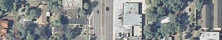
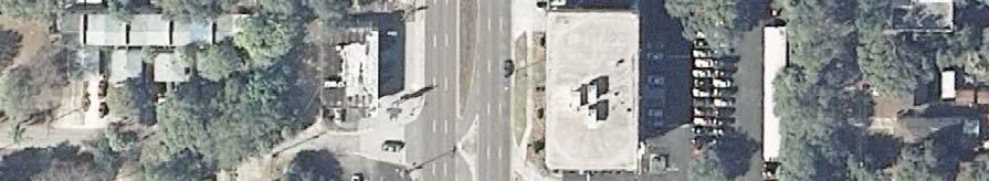
16 Kennedy Boulevard (SR 6) Access Management Safety Study Hillsborough County, Florida LOCATION ID: Median Opening 1-O MILEPOST:.748 CONDITION DIAGRAM CROSS STREET: Dale Mabry Highway Cash America Pawn 3 The Vitamin Shoppe Dale Mabry Highway TURN LANES STORAGE LENGTH {FT} APPROACH RIGHT LEFT STORAGE TAPER STORAGE TAPER SB NB EB WB Kennedy Blvd. 5 FedEx Office Plaza 3 44 CVS W N E S COLLISION DIAGRAM AM Peak Hour X Mid-Day Peak Hour X PM Peak Hour COLLISION SYMBOLS RIGHT ANGLE COLLISION LEFT TURN COLLISION OUT OF CONTROL SIDE SWIPE HEAD-ON COLLISION REAR END COLLISION FATAL CRASH INJURY CRASH BIKE PEDESTRIAN COLLISION TYPE NUMBER OF COLLISIONS COLLISION COLLISION SEVERITY TOTALS LEFT-TURN / ANGLE SUMMARY TOTALS PDO INJURY FATALITY 4-YR TOTAL AVG / YEAR INJ / FATAL LEFT-TURN ANGLE PEDESTRIAN / BICYCLE OTHER COLLISION TOTALS X A-9
17 Kennedy Boulevard Summary of Recommendations Bicycle and Pedestrian Safety Improvements Upgrade street lighting where needed. Provide a pedestrian crossing with raised median and RRFB control near Arawana Avenue. Provide high emphasis crosswalks and Yield to Pedestrians (R1-15) signs at all signalized intersections. At Willow Avenue, provide pedestrian features for the east/west pedestrian crossings. Install a new traffic signal at Rome Avenue with pedestrian crossing features. Access Management Safety Improvements to Reduce Conflicts (Westshore Himes 17 Median Openings) Close 5 existing median openings. Convert 3 existing full median openings to directional median openings. Lengthen left-turn lanes at 8 locations. Improvement Benefits Safer conditions for pedestrians and bicycles at signalized intersections (with high emphasis pavement markings and signs), Rome Avenue (with new traffic signal) and near Arawana Avenue (with new pedestrian crossing). Reduced right angle and left turn crashes along the corridor as a result fewer median openings and greater distance between median openings. Reduced rear-end and sideswipe crashes along the corridor as a result of longer storage areas in left turn lanes. Improved traffic flow conditions as a result of reduced conflicts and greater spacing between median opening intersections.

18 Westshore Blvd Walgreens 43 Taco Bell Chase Bank Trask St Burger King Mattress Firm Davids Bridal Lakeshore Learning Center Heperides St Continued Sheet McDonalds 85 Kennedy Blvd. Chevron Town Square Plaza FedEx Office GoGos Greek Grill Stonegate Bank Jimmy Johns Once Upon A Child Plaza Sports Retail Strip 85 ihospital Car Wash Median Opening 1-A Westshore Boulevard MP 1.68 Signalized Intersection 1. Lengthen W/B overall dual left-turn lane length to 76 feet in conjunction with proposed closure of Median Opening 1-B Median Opening 1-B Renellie Drive MP Close Median Opening Median Opening 1-C Trask Street MP Lengthen W/B left-turn lane to 85 feet in conjunction with proposed closure of Median Opening 1-D Median Opening 1-D Cooper Place MP Close Median Opening Median Opening 1-E Hesperides Street MP Convert to Bi-Directional Median Opening. Lengthen E/B left-turn lane to 85 feet in conjunction with proposed closure of Median Opening 1-D 3. Lengthen W/B left-turn lane to 85 feet in conjunction with proposed closure of Median Opening 1-F Concept Median Opening Plans for SR 6 (Kennedy Boulevard) From Westshore Blvd. to Brevard Ave. (NOT FOR CONSTRUCTION) Scale: 1 = 1 Kennedy Boulevard (SR 6) Access Management Safety Study Median Opening 1-A through 1-E Recommendations Sheet D-1
19 Continued Sheet 1 Fifth Third Bank Business Center Manhattan Ave Animal Clinic Plaza Mona s Florist Hubert Ave Continued Sheet Kennedy Blvd. Moore Clinical Research Plaza 18 Verizon Wireless Smoothie King 85 Regency at Westshore Apartment Homes 85 First Citrus Bank Dental Walk-In Clinic Median Opening 1-F Lauber Way MP 1.9 Directional Median Opening 1. Close Median Opening Median Opening 1-G Manhattan Avenue MP Lengthen E/B left-turn lane to 85 feet in conjunction with proposed closure of Median Opening 1-F. Lengthen W/B left-turn lane to 85 feet Median Opening 1-H Hubert Avenue MP Lengthen E/B left-turn lane to 85 feet. Lengthen W/B left-turn lane to 18 feet Concept Median Opening Plans for SR 6 (Kennedy Boulevard) From Westshore Blvd. to Brevard Ave. (NOT FOR CONSTRUCTION) Scale: 1 = 1 Kennedy Boulevard (SR 6) Access Management Safety Study Median Opening 1-F through 1-H Recommendations Sheet D-
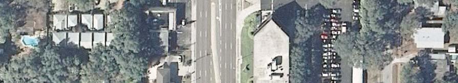
20 Continued Sheet Chevron Lois Ave BP 85 Cruises & More Sherwin-Willams Paints Jimbo s Pit Bar-B-Que Clark Ave Uniform City 5 Medi Weight Loss Plaza Hale Ave Radio Shack Plaza Kennedy Blvd. Continued Sheet 4 4 TD Bank Retail Plaza Regions Bank 5 Trans World Center Business Plaza Retail Plaza 85 Median Opening 1-I Lois Avenue MP Lengthen E/B left-turn lane to 4 feet. Lengthen W/B left-turn lane to 85 feet in conjunction with proposed closure of Median Opening 1-J Median Opening 1-J Krental Avenue MP Close Median Opening Median Opening 1-K Clark Avenue MP Convert to Bi-Directional Median Opening. Lengthen E/B left-turn lane to 5 feet in conjunction with proposed closure of Median Opening 1-J 3. Lengthen W/B left-turn lane to 5 feet in conjunction with proposed closure of Median Opening 1-L Median Opening 1-L Hale Avenue MP.4 1. Close Median Opening Business Plaza Concept Median Opening Plans for SR 6 (Kennedy Boulevard) From Westshore Blvd. to Brevard Ave. (NOT FOR CONSTRUCTION) Scale: 1 = 1 Kennedy Boulevard (SR 6) Access Management Safety Study Median Opening 1-I through 1-L Recommendations Sheet D-3
21 Continued Sheet 3 Grady Ave Mr. Empanada Plaza Fast Signs Plaza Church Ave Five Guys Plaza Calico Corners Cash America Pawn The Vitamin Shoppe Dale Mabry Highway Continued Sheet 5 Tampa Commons Business Park 39 Kennedy Blvd. Median Opening 1-M Grady Avenue MP Lengthen E/B left-turn lane to 85 feet in conjunction with proposed closure of Median Opening 1-L Kuhn Honda Dealership Median Opening 1-N Church Avenue MP 1.47 Directional Median Opening 1. NONE American Legion Cemetary American Legion FedEx Office Plaza Median Opening 1-O Dale Mabry Highway MP.748 Signalized Intersection 1. Lengthen W/B left-turn lane to 39 feet. CVS Concept Median Opening Plans for SR 6 (Kennedy Boulevard) From Westshore Blvd. to Brevard Ave. (NOT FOR CONSTRUCTION) Scale: 1 = 1 Kennedy Boulevard (SR 6) Access Management Safety Study Median Opening 1-M through 1-O Recommendations Sheet D-4
22 Sterling Ave Continued Sheet 4 Continued Sheet 6 Tampa Commons Business Park Sterling Plaza Retail Plaza Domino s Pizza Plaza Himes Ave Envy Nightclub Oregano Pizza 3 Papa Johns Pizza Kennedy Blvd. Church of Latter Day Saints Median Opening 1-P Sterling Avenue MP Convert to Bi-Directional Median Opening. Adjust E/B left-turn lane to feet 3. Adjust W/B left-turn lane to feet Renzo s Plaza 35 South Tampa Surgery Center Median Opening 1-Q Himes Avenue MP.999 Signalized Intersection 1. Lengthen E/B left-turn lane to 35 feet. Lengthen W/B left-turn lane to 3 feet Sprint Store Retail Plaza Concept Median Opening Plans for SR 6 (Kennedy Boulevard) From Westshore Blvd. to Brevard Ave. (NOT FOR CONSTRUCTION) Scale: 1 = 1 Kennedy Boulevard (SR 6) Access Management Safety Study Median Opening 1-P through 1-Q Recommendations Sheet D-5
Bay to Bay Boulevard Complete Streets Project
 Bay to Bay Boulevard Complete Streets Project Dale Mabry Highway to Bayshore Boulevard February 08, 2018 Photo Source: Tampa Bay Times Alessandra Da Pra Meeting Format Introduction Resurfacing Information
PEDESTRIAN SAFETY STUDY
 PEDESTRIAN SAFETY STUDY SR 699 (BLIND PASS RD/GULF BLVD) FROM 93 RD AVENUE TO PINELLAS BAYWAY PINELLAS COUNTY SECTION NO.: 15100 MILEPOST: 0.111 3.569 STUDY LIMITS Prepared For: Florida Department of Transportation
F L E T C H E R A V E N U E
 Jan. 29, 2014 Introduction F L E T C H E R A V E N U E FDOT Local Agency Program (LAP) Project FPN: 428214-1-58-01 CIP 63090 Hillsborough County, Traffic Engineering, PWD Stake holders and partners are
Financial Project ID No(s).: and ETDM No(s).: and 14181
.: and ETDM No(s).: and 14181") Palm Beach Metropolitan Planning Organization (MPO) Presentation I-95 at Boynton Beach Boulevard Interchange and I-95 at Gateway Boulevard Interchange Project Development and Environment Study Palm Beach
Palm Beach Metropolitan Planning Organization (MPO) Presentation I-95 at Boynton Beach Boulevard Interchange and I-95 at Gateway Boulevard Interchange Project Development and Environment Study Palm Beach
FINAL DESIGN TRAFFIC TECHNICAL MEMORANDUM
 FINAL DESIGN TRAFFIC TECHNICAL MEMORANDUM July 2014 FINAL (SR 43) Project Development and Environment Study From State Road 60 (Adamo Drive) to I-4 (SR 400) Hillsborough County, Florida Work Program Item
Gandy Connector: Travel Demand. Policy Committee August 2013
 Gandy Connector: Travel Demand Policy Committee August 2013 What options to the Gandy Elevated Lanes exist? What are the current conditions? Who s using Gandy Blvd? What s currently planned? What s been
About the study. North Milwaukee Ave. Key goals of this study are to: Achieve Vision Zero* by. Harmonize the space and improve walkability
 About the study Key goals of this study are to: North Milwaukee Avenue is a local and regional street for multiple modes of transportation. It is officially zoned and functions as a pedestrian street southeast
Dr. M.L. King, Jr. Street North Complete Streets Resurfacing Opportunities HOUSING, LAND USE, AND TRANSPORTATION COMMITTEE MARCH 22, 2018
 Dr. M.L. King, Jr. Street North Complete Streets Resurfacing Opportunities HOUSING, LAND USE, AND TRANSPORTATION COMMITTEE MARCH 22, 2018 What s Happening The City plans to mill and resurface Dr. M.L.
Station 1: Street & Sidewalk Upgrades
 Station 1: Street & Sidewalk Upgrades Existing no left turn; Potential left turn arrow, see Circulation Study boards for more information Thru-lane guidance Improved lead-in green bike lane 17TH ST CASTRO
Planning Study SR 976. Project Advisory Team Meeting May 24, 2017
 ` SR 976 BIRD ROAD/SW 40TH STREET FROM SR 821/HEFT TO SR 5/US-1 Miami-Dade County, Florida FPID No.: 434845-4-22-01 Planning Study Project Advisory Team Meeting May 24, 2017 1 Agenda Introductions Project
Safety Emphasis Areas & Safety Project Development Florida Department of Transportation District Seven Tampa Bay
 Safety Emphasis Areas & Safety Project Development Florida Department of Transportation District Seven Tampa Bay Stephen L. Benson, AICP, CNU-A FDOT District Seven Safety Office Presentation Overview Safety
Queensboro Bridge Bus Priority Study: Summary of Recommendations. Presentation to Manhattan Community Board 8 May 4, 2011
 : Summary of Recommendations Presentation to Manhattan Community Board 8 May 4, 2011 1 Overview Study Goal: Identify cost-effective ways to improve bus speed and reliability for local and express buses
FLORIDA DEPARTMENT OF TRANSPORTATION DISTRICT 7 DISTRICT WIDE BICYCLE/PEDESTRIAN ACCESS TO TRANSIT SAFETY ASSESSMENT AND IMPROVEMENT PLAN
 FLORIDA DEPARTMENT OF TRANSPORTATION DISTRICT 7 DISTRICT WIDE BICYCLE/PEDESTRIAN ACCESS TO TRANSIT SAFETY ASSESSMENT AND IMPROVEMENT PLAN TRANSIT SAFETY ASSESSMENT SR 55/US 19 AT 80 TH AVE N DRAFT JUNE
Implementation Plan and Design Guidelines. March 2009
 Implementation Plan and Design Guidelines March 2009 Table of Contents Chapter Page 1 INTRODUCTION...1-1 Framework...1-1 Guiding Principles...1-1 Study Area...1-2 Plan Components...1-2 2 IMPLEMENTATION
Poor pavement condition Substandard Intersections. / Substandard bike/pedestrian/transit accommodations. Driveway access Environmental concerns
 Public Informational Meeting University Avenue (Allen Boulevard Segoe Road) March 23, 2011 City of Madison City of Middleton Village of Shorewood Hills Dane County Existing Roadway Conditions Poor pavement
Joshua Saak, P.E., PTOE Traffic Design Engineer Ada County Highway District May 23, 2013
 Joshua Saak, P.E., PTOE Traffic Design Engineer Ada County Highway District May 23, 2013 Creating Great Streets Through Road Diets and Conversions The Charlotte Experience Topics to Discuss Charlotte s
US 41 (Tamiami Trail) Corridor Study. Roadway Safety Audit
 Corridor Study. Roadway Safety Audit") US 41 (Tamiami Trail) Corridor Study Roadway Safety Audit US 41 RSA June 14/15, 2017 Agenda Project Overview Schedule RSA Process Overview RSA Responsibilities Historical Crash Review 2 PROJECT OVERVIEW
US 41 (Tamiami Trail) Corridor Study Roadway Safety Audit US 41 RSA June 14/15, 2017 Agenda Project Overview Schedule RSA Process Overview RSA Responsibilities Historical Crash Review 2 PROJECT OVERVIEW
Glenn Avenue Corridor Traffic Operational Evaluation
 Glenn Avenue Corridor Traffic Operational Evaluation PREPARED FOR: THE CITY OF AUBURN PREPARED BY: DECEMBER 2007 Glenn Avenue Corridor Study--Auburn, Alabama TABLE OF CONTENTS Introduction... 1 Background
MAKE YOUR PLACE IN CHANNELSIDE
 MAKE YOUR PLACE IN CHANNELSIDE INTRODUCTION PROJECT LIMITS Channelside Drive from Cumberland Ave to Kennedy Boulevard EXISTING CONDITIONS EXISTING CONDITIONS CHANNELSIDE DRIVE FROM E. CUMBERLAND AVENUE
J Street and Folsom Boulevard Lane Conversion Project (T ) Before and After Traffic Evaluation
 Before and After Traffic Evaluation") J Street and Folsom Boulevard Lane Conversion Project (T15125400) Before and After Traffic Evaluation Prepared by Transportation Division June 2014 Executive Summary On February 12, 2013, the City of Sacramento
J Street and Folsom Boulevard Lane Conversion Project (T15125400) Before and After Traffic Evaluation Prepared by Transportation Division June 2014 Executive Summary On February 12, 2013, the City of Sacramento
Lincoln Avenue Road Diet Trial
 Lincoln Avenue Road Diet Trial Data Collection Report June 1, 2015 Department of Transportation Table of Contents I. Introduction...... 3 II. Data Collection Methodology & Results...... 5 A. Traffic Volume
FINAL REPORT - Revised from original submittal -
 FINAL REPORT - Revised from original submittal - Comparing Street Lighting Levels with Nighttime Crash Histories -VOLUME I- Submitted to: Florida Department of Transportation District 7 11201 N Malcolm
UPDATES, SUCCESSES, AND WHAT S AHEAD ON THE ROAD TO ZERO
 Vol. 1, Issue 1 I Spring 2018 www.planhillsborough.org/vision-zero S A F E S T R E E T S N O W H I L L S B O R O U G H UPDATES, SUCCESSES, AND WHAT S AHEAD ON THE ROAD TO ZERO TRACKING PROGRESS This is
BICYCLE/PEDESTRIAN ACCESS TO TRANSIT SAFETY ASSESSMENT FOR EXISTING AND PLANNED SECTIONS OF US 19
 BICYCLE/PEDESTRIAN ACCESS TO TRANSIT SAFETY ASSESSMENT FOR EXISTING AND PLANNED SECTIONS OF US 19 Project Advisory Committee Meeting December 2, 2015 A JOINT EFFORT OF THE PINELLAS METROPOLITAN PLANNING
SR 580/West Hillsborough Avenue Multimodal Improvements Feasibility and Cost Estimation
 SR 580/West Hillsborough Avenue Multimodal Improvements Feasibility and Cost Estimation April 2018 Completed For: In Coordination With: Hillsborough County Metropolitan Planning Organization 601 East West
Donahue Drive Corridor Traffic Operational Evaluation
 Donahue Drive Corridor Traffic Operational Evaluation PREPARED FOR: THE CITY OF AUBURN PREPARED BY: JANUARY 2007 Donahue Drive Corridor Study--Auburn, Alabama TABLE OF CONTENTS Introduction... 1 Background
THE NACTO MANUALS AND DESIGNING FOR VISION ZERO ZAKI MUSTAFA SHIRLEY ZAMORA
 THE NACTO MANUALS AND DESIGNING FOR VISION ZERO ZAKI MUSTAFA SHIRLEY ZAMORA NACTO Design Guides 2 City of Los Angeles Vision Zero 3 Vision Zero Roscoe Boulevard Corridor SHIRLEY ZAMORA TRANSPORTATION ENGINEERING
Emerging Methods for Evaluating Transportation Systems Multimodal LOS and Highway Safety Manual
 Emerging Methods for Evaluating Transportation Systems Multimodal LOS and Highway Safety Manual November 8, 2012 Lake Merritt Tower in Oakland Transportation Education Series 1 Presenters Mark Bowman,
Effects of Traffic Signal Retiming on Safety. Peter J. Yauch, P.E., PTOE Program Manager, TSM&O Albeck Gerken, Inc.
 Effects of Traffic Signal Retiming on Safety Peter J. Yauch, P.E., PTOE Program Manager, TSM&O Albeck Gerken, Inc. Introduction It has long been recognized that traffic signal timing can have an impact
Transportation Planning Division
 Transportation Planning Division Presentation Outline Study Tasks Recap of Previous Meetings Data Collected Focus Areas within Study Limits Design Principles Tool Box Recommended Concepts Schedule Moving
Pinellas County Metropolitan Planning Organization (MPO) 2014 Crash Data Report
 2014 Crash Data Report") Pinellas County Metropolitan Planning Organization (MPO) 2014 Crash Data Report MPO Board July 8, 2015 2 Crash Data Collection Motorcycle drove between stopped cars, ran a red light and collided with a
Pinellas County Metropolitan Planning Organization (MPO) 2014 Crash Data Report MPO Board July 8, 2015 2 Crash Data Collection Motorcycle drove between stopped cars, ran a red light and collided with a
Feasibility Study of Pedestrian Crossings Along Route 7, East of Cascades Parkway and West of Dranesville Road. October 3, 2017
 Feasibility Study of Pedestrian Crossings Along Route 7, East of Cascades Parkway and West of Dranesville Road October 3, 2017 Study Area (area within a ¼-mile radius of the study intersections) Route
Gateway Transportation Study
 Gateway Transportation Study Amherst, Massachusetts SUBMITTED TO University of Massachusetts Amherst Town of Amherst SUBMITTED BY Vanasse Hangen Brustlin, Inc. Watertown, Massachusetts March 213 Back of
Road Diets FDOT Process
 Florida Department of TRANSPORTATION Road Diets FDOT Process Humberto Castillero, PE, PTOE Roadway Design Office Purpose of Guide Develop a statewide lane elimination review process Balance state & local
Lakeland Area Alternatives Analysis
 Lakeland Area Alternatives Analysis DRAFT Preliminary Safety Assessment SR /Lakeland Hills Boulevard December 7 Project Limits: from US 9/Memorial Boulevard to North of Socrum Loop Road Polk County, Florida
FDOT Bicycle/Pedestrian Focused Initiative & Complete Streets
 Florida Department of TRANSPORTATION FDOT Bicycle/Pedestrian Focused Initiative & Complete Streets Billy L. Hattaway, PE District One Secretary Secretary s Pedestrian Safety Initiative Dangerous by Design
Access Management Benefits & Techniques. Access Management Workshop June 2, 2006
 Access Management Benefits & Techniques Access Management Workshop June 2, 2006 1 Benefits of Access Management Safety As access density increases, crash rates increase Increasing the density of access
Designing for Pedestrian Safety. Alabama Department of Transportation Pre-Construction Conference May 2016
 Designing for Pedestrian Safety Alabama Department of Transportation Pre-Construction Conference May 2016 1 Designing for Pedestrians Marking Crosswalks at Signalized intersections High Visibility Markings
Agenda. Overview PRINCE GEORGE S PLAZA METRO AREA PEDESTRIAN PLAN
 PRINCE GEORGE S PLAZA METRO AREA PEDESTRIAN PLAN May 28, 2008 Agenda Welcome and introductions Project overview and issue identification Planning context and strengths Design challenges and initial recommendations
Orange Center Elementary School
 Drag and drop pic and stretch/crop to the limits of the blue rectangle (delete this text box) Orange Center Elementary School Drag and drop pic and stretch/crop to the limits of the blue rectangle (delete
District Three Safety Office
 District Three Safety Office SR 363/S. Adams Street From SR 61/Paul Russell Road to SR 373/Orange Avenue Leon County Safety Study: Arterial (Pedestrian) Prepared by: Cardno Completion Date: July 2016 SR
Pinellas County Safety Initiatives
 Florida Department of TRANSPORTATION Pinellas County Safety Initiatives Whit Blanton, FAICP Pinellas County MPO A Distinctive County A unique geography Multi-jurisdictional Key demographics seniors and
PEDESTRIAN ACCOMMODATIONS DPS 201 AT INTERCHANGES
 PEDESTRIAN ACCOMMODATIONS DPS 201 AT INTERCHANGES UNDERSTANDING THE ISSUES Intersections of freeway ramp terminals at crossroads are the most critical components of an interchange Challenge: balance mobility
Road Diets and Roundabouts
 Road Diets and Roundabouts Paul Zykofsky, AICP Local Government Commission Sacramento, CA Classic Road Diet 4 to 3 lanes San Antonio TX On-street parking Median Bike Lanes Center Turn-Lane Seattle WA Road
MIT Kendall Square Initiative
 MIT Kendall Square Initiative Volume II: Technical Studies and Information (NoMa Project and SoMa Project) Final Development Plan Submission Cambridge Planning Board #302 and #303 November 5, Submitted
Pedestrian Safety at Roundabouts. Presentation to the Howard-Suamico School Board November 26, 2007
 Pedestrian Safety at Roundabouts Presentation to the Howard-Suamico School Board November 26, 2007 Roundabouts that have replaced stop signs and traffic signals have reduced the number and severity of
TRAFFIC IMPACT ANALYSIS
 TRAFFIC IMPACT ANALYSIS FOR THE CHAMPAIGN UNIT#4 SCHOOL DISTRICT PROPOSED HIGH SCHOOL (SPALDING PARK SITE) IN THE CITY OF CHAMPAIGN Final Report Champaign Urbana Urbanized Area Transportation Study 6/24/2014
Presentation Outline. Project/Study Purpose. Existing Conditions. Future Conditions. Understanding the Streetside. Similar Walkable Environments
 Presentation Outline Project/Study Purpose Study Area Map Existing Conditions Future Conditions Understanding the Streetside Similar Walkable Environments Conceptual Alternatives Magnolia/NE 1st Ave Block
LANE ELIMINATION PROJECTS
 PRESENTATION OUTLINE Lane Elimination Considerations Districts 4 & 7 Draft Lane Elimination Processes FDOT Lane Elimination Guidelines Example Projects D4 Case Study: SR A1A (Ft. Lauderdale) D7 Case Study:
List of Exhibits...ii
 One Brickell Traffic Study TABLE OF CONTENTS List of Exhibits...ii EXECUTIVE SUMMARY...1 1. INTRODUCTION...2 1.1 Study Area...2 1.2 Study Objective...5 2. EXISTING TRAFFIC CONDITIONS...6 2.1 Data Collection...6
MEMORANDUM. DATE March 1, 2012 TO Town of Milton Mark Abbott, Seth Asante, and Efi Pagitsas Boston Region MPO Staff
 MEMORANDUM DATE March 1, 212 TO Town of Milton FROM RE Mark Abbott, Seth Asante, and Efi Pagitsas Boston Region MPO Staff FFY 211 Safety and Operations Analyses at Selected Boston Region MPO Intersections:
Complete Street Analysis of a Road Diet: Orange Grove Boulevard, Pasadena, CA
 Complete Street Analysis of a Road Diet: Orange Grove Boulevard, Pasadena, CA Aaron Elias, Bill Cisco Abstract As part of evaluating the feasibility of a road diet on Orange Grove Boulevard in Pasadena,
Acknowledgements. Mr. David Nicol 3/23/2012. Daniel Camacho, P.E. Highway Engineer Federal Highway Administration Puerto Rico Division
 Daniel Camacho, P.E. Highway Engineer Federal Highway Administration Puerto Rico Division Acknowledgements Mr. David Nicol Director, FHWA Office of Safety FHWA Office of Safety http://safety.fhwa.dot.gov/provencountermeasures/
INTERSECTION CONTROL NOVEMBER 2018
 INTERSECTION CONTROL NOVEMBER 2018 ICE OVERVIEW AGENDA Why ICE? When ICE is Required? Applicability and Process 2 AVAILABLE RESOURCES http://www.fdot.gov/traffic/trafficservices/intersection_operations.shtm
EXISTING PRIORITIES FUNDED FOR CONSTRUCTION LRTP
 EXISTING PRIORITIES FUNDED FOR CONSTRUCTION Limits Description Status 1 415489 3 H1865 US HWY 301 FROM SR 674 TO BALM RD Widen 2 lanes to 6 lanes divided County / Construction Programmed 2016 2 405492
Toolbox of Countermeasures and Their Potential Effectiveness to Make Intersections Safer
 8 Toolbox of Countermeasures and Their to Make Intersections Safer Introduction Studies included in the NCHRP 17-18 (3), Guidance for Implementation of the AASHTO Strategic Highway Safety Plan, as well
Route 7 Corridor Study
 Route 7 Corridor Study Executive Summary Study Area The following report analyzes a segment of the Virginia State Route 7 corridor. The corridor study area, spanning over 5 miles in length, is a multi
TRAFFIC CONTROL DEVICES ON EDGEWATER BOULEVARD AT PORT ROYAL AVENUE (NORTH)
") Attachment 2 DATE: August 6, 2012 TO: VIA: FROM: SUBJECT: Mayor and Members of the City Council James C. Hardy, City Manager Ramon Towne, Director of Public Works Leah Edwards, Assistant Engineer TRAFFIC
Attachment 2 DATE: August 6, 2012 TO: VIA: FROM: SUBJECT: Mayor and Members of the City Council James C. Hardy, City Manager Ramon Towne, Director of Public Works Leah Edwards, Assistant Engineer TRAFFIC
M-58 HIGHWAY ACCESS MANAGEMENT STUDY Mullen Road to Bel-Ray Boulevard. Prepared for CITY OF BELTON. May 2016
 M-58 HIGHWAY ACCESS MANAGEMENT STUDY Prepared for CITY OF BELTON By May 2016 Introduction Missouri State Highway 58 (M-58 Highway) is a major commercial corridor in the City of Belton. As development has
FORM A PASCO COUNTY ACCESS CONNECTION PERMIT APPLICATION
 FORM 901.3.A PASCO COUNTY ACCESS CONNECTION PERMIT APPLICATION The following information is required from all applicants directly or indirectly accessing any collector or arterial road or as otherwise
Comments EXECUTIVE SUMMARY
 Comments 1. Under any Alternatives, MCDOT should provide better at-grade pedestrian crossing of Georgia Avenue and Forest Glen Road, including improved crosswalks with wider medians and adequate signal
Evaluation of M-99 (Broad Street) Road Diet and Intersection Operational Investigation
 Road Diet and Intersection Operational Investigation") Evaluation of M-99 (Broad Street) Road Diet and Intersection Operational Investigation City of Hillsdale, Hillsdale County, Michigan June 16, 2016 Final Report Prepared for City of Hillsdale 97 North Broad
Evaluation of M-99 (Broad Street) Road Diet and Intersection Operational Investigation City of Hillsdale, Hillsdale County, Michigan June 16, 2016 Final Report Prepared for City of Hillsdale 97 North Broad
Public Involvement Meeting Tuesday, June 13, Albany Shaker Road Corridor Study
 Public Involvement Meeting Tuesday, June 13, 2017 Albany Shaker Road Corridor Study Agenda / Meeting Outline 1. Introduce the project 2. Complete Streets 3. Share/confirm our findings 4. Your Opinion 5.
Pedestrian & Bicycle Safety Innovations & Applications
 Pedestrian & Bicycle Safety Innovations & Applications County Engineers Association of Maryland Spring, 2017 Conference May 25, 2017 George Branyan Pedestrian Program Coordinator District Department of
Ottawa Beach Road Study
 Ottawa Beach Road Study Prepared For: Park Township September 30, 2014 Project No. G140303 OTTAWA BEACH ROAD STUDY PREPARED FOR: PARK TOWNSHIP SEPTEMBER 30, 2014 PROJECT NO. G140303 TABLE OF CONTENTS 1.0
Waterford Lakes Small Area Study
 Waterford Lakes Small Area Study Existing Traffic Conditions PREPARED FOR: ORANGE COUNTY PUBLIC WORKS DEPARTMENT TRAFFIC ENGINEERING DIVISION ORLANDO, FLORIDA PREPARED WITH: INWOOD CONSULTING ENGINEERS
Boston Post Road Design Feasibility Study
 Boston Post Road Design Feasibility Study Prepared for the City of Rye Final Report July 18, 2007 Prepared by: Buckhurst Fish & Jacquemart (BFJ) 115 Fifth Avenue New York, NY 10003 www.bfjplanning.com
US 19 PEDESTRIAN AND BICYCLE SAFE ACCESS
 US 19 PEDESTRIAN AND BICYCLE SAFE ACCESS TO TRANSIT CORRIDOR STUDY A JOINT EFFORT OF THE FLORIDA DEPARTMENT OF TRANSPORTATION AND FORWARD PINELLAS (F.K.A. PINELLAS COUNTY METROPOLITAN PLANNING ORGANIZATION)
Date: April 4, Project #: Re: A Street/Binford Street Traffic/Intersection Assessment
 To: Peter Cavanaugh General Electric From: David Bohn, PE Ryan White, PE Date: April 4, 217 Project #: 13421. Re: / Traffic/Intersection Assessment Consistent with the Cooperation Agreement between the
SR 693 (Pasadena Avenue) Corridor Study from Shore Drive South to 66 th Street
 Corridor Study from Shore Drive South to 66 th Street") Welcome and Introduction Sign-in and comment sheets Restrooms and exits Meeting agenda and timeline Meeting goals / expectations Provide input to guide study recommendations Actively participate throughout
Welcome and Introduction Sign-in and comment sheets Restrooms and exits Meeting agenda and timeline Meeting goals / expectations Provide input to guide study recommendations Actively participate throughout
BOARD OF COUNTY COMMISSIONERS AGENDA ITEM SUMMARY
 7B BOARD OF COUNTY COMMISSIONERS AGENDA ITEM SUMMARY PLACEMENT: REQUESTS AND PRESENTATIONS PRESET: TITLE: FLORIDA DEPARTMENT OF TRANSPORTATION (FDOT) PRESENTATION RECONSTRUCTION OF SR-76 (SW KANNER HIGHWAY)
Overview of FDOT District 7 Safety Programs and Initiatives in Tampa Bay, FL
 Overview of FDOT District 7 Safety Programs and Initiatives in Tampa Bay, FL Executive Safety Summit Florida Department of Transportation District 7 June 8, 2011 Peter Hsu, P.E. District Safety & Special
Welcome and Introduction
 1 Welcome and Introduction Name and Title Organization One word that best describes Alternate US 19 today One word that best describes your vision for Alternate US 19 2 Today s Agenda Agenda Item From
SR 907 (Alton Road) between Barry Street and 41 st Street
 between Barry Street and 41 st Street") TWO 20 Pedestrian Safety Study SR 907 (Alton Road) between Barry Street and 41 st Street Miami Beach, Miami-Dade County DRAFT Florida Department of Transportation District VI June 2014 TWO 20 Pedestrian
TWO 20 Pedestrian Safety Study SR 907 (Alton Road) between Barry Street and 41 st Street Miami Beach, Miami-Dade County DRAFT Florida Department of Transportation District VI June 2014 TWO 20 Pedestrian
MOBILITY WORKSHOP. Joint City Council and Transportation Commission May 5, 2014
 MOBILITY WORKSHOP Joint City Council and Transportation Commission May 5, 2014 Review of General Plan M-1 Develop world-class transit system M-3 Maintain/enhance pedestrian-oriented City M-4 Create comprehensive
Street Design Workshop. Existing cross section Traffic volumes Examine adjacent land uses You design future improvements
 Street Design Workshop Existing cross section Traffic volumes Examine adjacent land uses You design future improvements Primary Tools for Street Redesign Road diets Bike lanes Cycle tracks Trails Crosswalks
Military Road Safety Improvements
 Military Road Safety Improvements 26 th Road North to 31 st Street North SUMMARY OF DATA REVIEW AND PRELIMINARY RECOMMENDATIONS Prepared for: Department of Environmental Services Traffic Engineering and
Brian McHugh, Buckhead Community Improvement District. SUBJECT: Wieuca Road at Phipps Boulevard Intersection Improvements Project
 MEMO TO: FROM: Brian McHugh, Buckhead Community Improvement District Jagan Kaja, AICP, WSP Parsons Brinckerhoff SUBJECT: Wieuca Road at Phipps Boulevard Intersection Improvements Project DATE: October
Access Management Regulations and Standards
 Access Management Regulations and Standards Efficient highway operation Reasonable property access Concept of Access Management The way to manage access to land development while simultaneously preserving
Citizen Advisory Group Meeting #8 May 5, Welcome. Today s meeting will focus on: Land Use & Transportation CHARLOTTEPLANNING.
 Citizen Advisory Group Meeting #8 May 5, 2010 Welcome. Today s meeting will focus on: Land Use & Transportation CHARLOTTEPLANNING.ORG Meeting Agenda Handouts: o Meeting Agenda o Summary of East Seventh
Innovative Intersections
 Innovative Intersections Things You Need to Know About FDOT D-7 Safety Academy October 19, 2016 Mark Doctor FHWA Resource Center Atlanta, GA HOW DO YOU FEEL??? about innovative intersections??? Why is
DEPARTMENT OF ENVIRONMENTAL SERVICES. North Harrison Street (Lee Highway to Little Falls Road) Comparative Analysis. Prepared for:
 Comparative Analysis. Prepared for:") DEPARTMENT OF ENVIRONMENTAL SERVICES North Harrison Street (Lee Highway to Little Falls Road) Comparative Analysis Prepared for: Arlington County Department of Environmental Services 2100 Clarendon Boulevard,
DEPARTMENT OF ENVIRONMENTAL SERVICES North Harrison Street (Lee Highway to Little Falls Road) Comparative Analysis Prepared for: Arlington County Department of Environmental Services 2100 Clarendon Boulevard,
CITY OF CASSELBERRY WINTER PARK DRIVE IMPROVEMENT STUDY
 CITY OF CASSELBERRY WINTER PARK DRIVE IMPROVEMENT STUDY Preliminary Recommendations October 2018 2014 HDR, Inc., all rights reserved. PROJECT BACKGROUND WALKING AUDIT FINDINGS PROPOSED IMPROVEMENT CONCEPTS
OCALA/MARION TPO CITY OF BELLEVIEW CORRIDOR PLAN STUDY PRESENTATION TO THE BELLEVIEW CITY COMMISSION JANUARY 25, :00 PM
 OCALA/MARION TPO CITY OF BELLEVIEW CORRIDOR PLAN STUDY PRESENTATION TO THE BELLEVIEW CITY COMMISSION JANUARY 25, 2016 6:00 PM STUDY AREA Ocala/Marion TPO US-441 Corridor Study 2 Ocala/Marion TPO US-441
PUBLIC REALM MASTER PLAN
 WESTSHORE BUSINESS DISTRICT PUBLIC REALM MASTER PLAN MASTER PLAN COMMITTEE MEETING MARCH 20, 2013 WESTSHORE BUSINESS DISTRCT PUBLIC REALM MASTER PLAN MACRO-SCALE CONCEPT: A PUBLIC REALM FRAMEWORK DEFINED
Project Goals and Objectives
 Project Goals and Objectives Goal 1: Goal 2: Goal 3: Transform Coast Highway into a Complete Street that accommodates all roadway users (pedestrians, bicyclists, and autos) Objectives: Improve the pedestrian
Town of Bethlehem. Planning Assessment. Bethlehem Town Board
 Town of Bethlehem US 9W Corridor Transportation Planning Assessment Presented e to: Bethlehem Town Board June 2009 Overview Study Background Route 9W Corridor Conditions and Improvements Selkirk Bypass
draft Benefit Cost Analysis Agassiz Rosedale Highway 9/Yale Road East Intersection Improvement Apex Engineering Limited Prepared for:
 draft Benefit Cost Analysis Agassiz Rosedale Highway 9/Yale Road East Intersection Improvement Prepared for: BC Ministry of Transportation South Coast Region Prepared by: Apex Engineering 4299 West 14
Bicycle Crashes. Number of Bike Crashes. Total Bike Crashes. are down 21% and severe bike crashes down 8% since 2013 (5 years).
.") Bicycle Crashes The City of Fort Collins is well known for its bike culture, and there is a strong focus on encouraging increased riding. Bike safety is an important component of supporting these efforts.
Bicycle Crashes The City of Fort Collins is well known for its bike culture, and there is a strong focus on encouraging increased riding. Bike safety is an important component of supporting these efforts.
By Dan Burden, Executive Director Walkable and Livable Communities Institute
 By Dan Burden, Executive Director Walkable and Livable Communities Institute Is this the landscape we want to leave our children? LaJolla Boulevard, Birdrock, San Diego, CA 78 Feet Speeds above
Crash Data Analysis for Converting 4-lane Roadway to 5-lane Roadway in Urban Areas
 Crash Data Analysis for Converting 4-lane Roadway to 5-lane Roadway in Urban Areas Xiaoduan Sun, University of Louisiana at Lafayette Nicholas P. Fruge, LADOTD District 3 Subasish Das, University of Louisiana
Traffic Signals at Bike Boulevards
 Traffic Signals at Bike Boulevards A Review of Eight Locations in Seattle Presented at ITE Western District Annual Meeting July 13 th, 2016 Introduction What? Analysis of eight intersections before and
DRAFT. Corridor study. Honeysuckle Road. October Prepared for the City of Dothan, AL. Prepared by Gresham, Smith and Partners
 DRAFT Corridor study Honeysuckle Road October 2017 Prepared for the City of Dothan, AL Prepared by TABLE OF CONTENTS SECTION I... 1 STUDY SUMMARY... 1 INTRODUCTION... 1 CONCLUSIONS... 5 SECTION II... 7
NY Route 5 Comprehensive Pedestrian Safety Study: A Corridor Perspective CDTC Planning Committee. January 7, 2015
 NY Route 5 Comprehensive Pedestrian Safety Study: A Corridor Perspective CDTC Planning Committee January 7, 2015 Project Objective Study Scope: Perform an analysis of pedestrian related accidents, An engineering
ALLEY 24 TRAFFIC STUDY
 ALLEY 24 TRAFFIC STUDY in City of Frostburg, Maryland January 2013 3566 Teays Valley Road Hurricane, WV Office: (304) 397-5508 www.denniscorporation.com Alley 24 Traffic Study January 2013 Frostburg, Maryland
US 278 Corridor Concept Presentation. Avondale Estates Intersection Improvement/Roundabout and Road Diet Feasibility Study March 19, 2015
 US 278 Corridor Concept Presentation Avondale Estates Intersection Improvement/Roundabout and Road Diet Feasibility Study March 19, 2015 Thanks to our Partners Atlanta Regional Commission Georgia Department
Columbia Pike Implementation Team (CPIT) Meeting
 Meeting") Columbia Pike Implementation Team (CPIT) Meeting November 30, 2010 Agenda Introductions / Purpose of Meeting Review of project goals Multimodal project: 10% street design between the curbs Discussion Multimodal
Columbia Pike Implementation Team (CPIT) Meeting November 30, 2010 Agenda Introductions / Purpose of Meeting Review of project goals Multimodal project: 10% street design between the curbs Discussion Multimodal
Downtown Naples Mobility and Connectivity Study. Naples City Council Presentation January 2017
 Downtown Naples Mobility and Connectivity Study Naples City Council Presentation January 2017 Agenda 1. Introduction 2. Scope Review 3. Project Schedule 4. Existing Conditions 5. Public Charrette 6. Mobility
February 11, 2016 TPO Board Presentation
 February 11, 2016 TPO Board Presentation SR A1A (Highway A1A) US 192 to SR 404 (Pineda Causeway), Brevard County, Florida Financial Project Number: 428753-1-32-01 Project Limits US 192 to SR 404 (428753-1)
Fundamentals of Traffic Control Devices
 Fundamentals of Traffic Control Devices Traffic Engineering & Operations October 8, 2014 Raj Ponnaluri, Angela Wilhelm, and Christopher Lewis Agenda Agenda Signs Pavement Markings Signals Traffic Operations