Capital Region Transportation Planning Agency ADOPTED RMP Roadways Priority Project List Fiscal Year Fiscal Year 2024
|
|
|
- Rodger Hall
- 5 years ago
- Views:
Transcription
1 Capital Region Transportation Planning Agency ADOPTED RMP Roadways Priority Project List Fiscal Year Fiscal Year 2024 Priority RMP ID# Project Name/Limits FDOT WPI# Programmed Funding Project/Strategy County SIS Length (miles) Funding Sought Woodville Highway 1 Phase (Capital Circle, SE to Gaile Ave) ROW $773,885 Widen to 4 lanes Leon 2.1 CST ($17.4M) 4 (Gaile Ave to Paul Russell Rd) ROW $4.9M $ 1.1M CST ($6.8M) Capital Circle, Southwest 2 Phase (Crawfordville Rd to Springhill Rd) ROW $4.7M $3M CST $32.6M Widen to 6 lanes Leon 2.34 FULLY FUNDED* Crawfordville Road Phase (N. of Alaska Way to Lost Creek Bridge) ROW $2.6M Widen to 4 lanes Wakulla 3.6 ROW ($34.1M) 4 CST ($27M) Crawfordville Road Phase (Lost Creek Bridge to East Ivan Rd) Widen to 4 lanes Wakulla 4.4 ROW ($30M) 4 CST ($41M) Orange Avenue 2 Phase (Capital Circle, SW to Monroe St) PD&E $1.5M Widen to 4 lanes Leon 4.3 Design 6 75 Thomasville Rd/Meridian Rd/7th Ave 3 Phase (Midtown Operational Improvements) - Intersection Improvements Leon - PD&E Mahan Dr and Capital Circle, NE Phase (Intersection Improvements) Intersection Improvements Leon Y - Feasibility Study Pensacola Street (West Side Student Phase Corridor Gateway 1 ) (Capital Circle, NW to Appleyard Dr) Widen to 4 lanes Leon 0.8 PD&E Reevaluation 9 Crawfordville Road Phase (LL Wallace Rd to beginning of 4-lane) Widen to 4 lanes Leon 1.7 PE ($2.09M) 4 (Wakulla County Line to LL Wallace Rd) PE ($1.8M) Lake Bradford Road/Springhill Road 1 Phase (Capital Circle, SW to Gaines Street) Corridor Improvements Leon 3.8 PD&E Tharpe Street 2 Phase (Capital Circle, NW to Ocala Rd) Widen to 4 lanes Leon 2.7 PD&E Reevaluation Bannerman Road 2 Phase (Tekesta Dr to Thomasville Rd) - Widen to 4 lanes Leon 1.7 PE
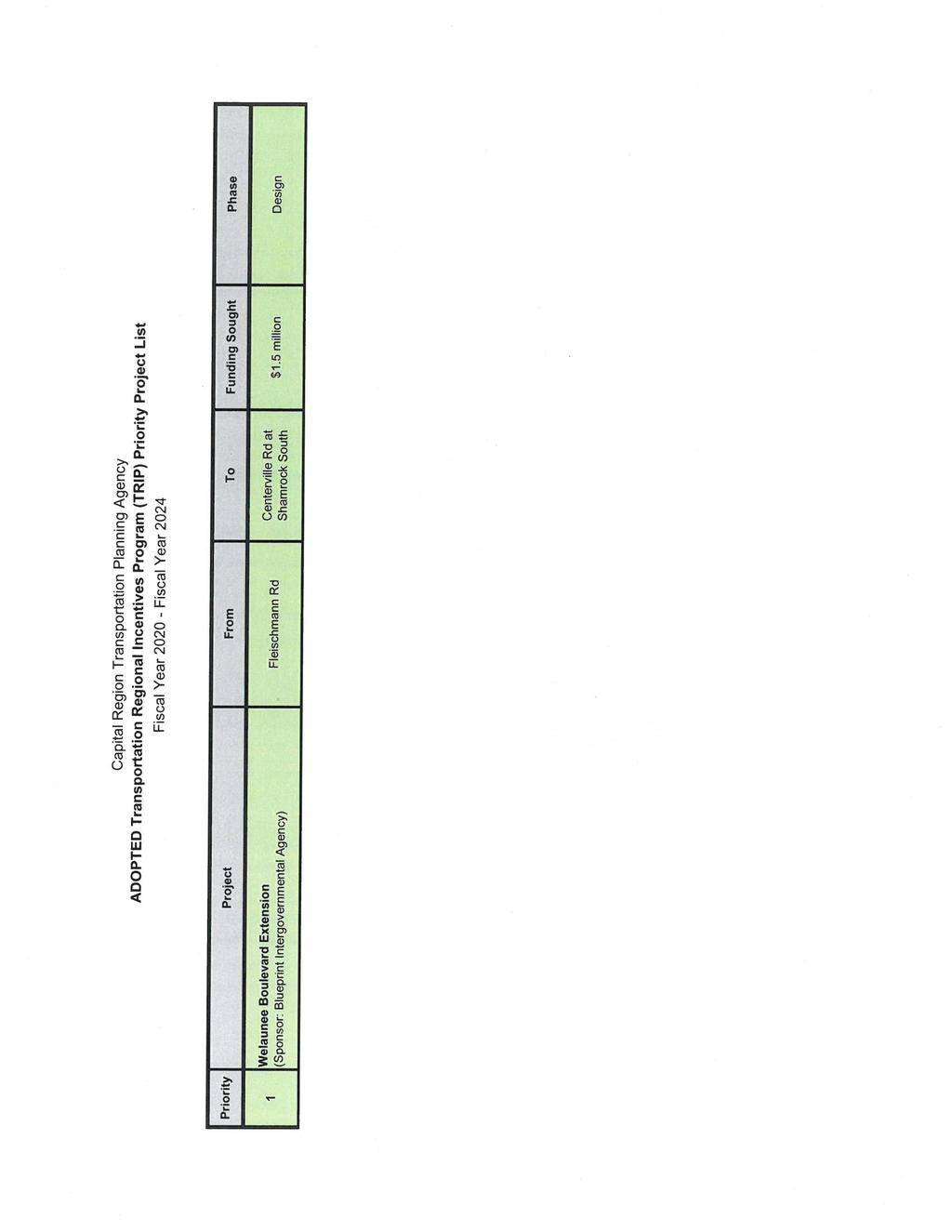
2 Capital Region Transportation Planning Agency ADOPTED RMP Roadways Priority Project List Fiscal Year Fiscal Year 2024 Priority RMP ID# Project Name/Limits FDOT WPI# Programmed Funding Project/Strategy County SIS Length (miles) Funding Sought Welaunee Blvd Extension 1 Phase (Fleischmann Rd to south of I-10) Blueprint PD&E $625,000 PE $250,000 $1M New 4 lane road Leon 2.25 CST Welaunee Blvd Extension 1 Phase (South of I-10 to Shamrock St) Blueprint PD&E $625,000 PE $250,000 $1M New 4 lane road Leon 2 ROW/CST Welaunee Blvd/I-10 Interchange Phase New Interchange Leon Y - PD&E 1 Blueprint Gateway Project ABBREVIATIONS: 2 Blueprint Regional Mobility Project PD&E - Project Development and Environment Study 3 Blueprint Community Enhancement District PE - Preliminary Engineering (Design) 4 FDOT Long Range Estimate (LRE) ROW - Right-of-Way * Fully Funded Projects are retained on the list above until such funding is within the first three (3) years of the TIP. CST - Construction SIS - Strategic Intermodal System (FDOT roadway designation) FULLY FUNDED PROJECTS (NOT YET CONSTRUCTED): 382 Capital Circle, Southwest 2 Phase (Springhill Rd to Orange Ave) CST $56.5M Widen to 6 lanes Leon Y 4.1 FULLY FUNDED
3 Capital Region Transportation Planning Agency ADOPTED RMP Bicycle and Pedestrian Priority Project List Fiscal Year Fiscal Year 2024 Priority RMP ID# Project Name/Limits FDOT WPI# Programmed Funding Project/Strategy County Monticello Bike Trail Extension Phase (Southern Terminus of Monticello to Jefferson Co Middle/High School) Shared Use Path Jefferson 2.4 Length (miles) Funding Sought ** PD&E/PE Wakulla Environmental Institute Phase (US 98 to WEI) Shared Use Path Wakulla 1.4 PD&E/PE Goose Pond Trail* Phase (Mahan Dr/Fort Knox to Weems Rd) Shared Use Path Leon 1.2 PD&E Florida Arts Trail Phase (N Corry St to Florida Georgia Hwy) Shared Use Path Gadsden 11 PE US 90 Trail Phase Shared Use Path Gadsden 10.7 PD&E (Madison St to Dover Rd) Martin Rd Trail Phase (Monticello Bike Trail to US 19) Shared Use Path Jefferson 0.3 PD&E Thomasville Rd Trail* Phase (Meridian Rd to Live Oak Plantation Rd) Shared Use Path Leon 3.7 PD&E * Also a Blueprint Intergovernmental Agency project ** ABBREVIATIONS: PD&E - Project Development and Environment Study PE - Preliminary Engineering CST - Construction ROW - Right-of-Way *** Note: Fully Funded Projects are retained on the list until such funding is within the first three (3) years of the TIP. FULLY FUNDED PROJECTS (NOT YET CONSTRUCTED): 422 Glenview Drive Phase (Meridian Rd to Thomasville Rd) CST $276,946 Sidewalk Leon 0.44 FULLY FUNDED
4 Capital Region Transportation Planning Agency ADOPTED Regional Trails Priority Project List Fiscal Year Fiscal Year 2024 Priority RMP ID# Project Name/Limits FDOT WPI# Programmed Funding Project/Strategy County Coastal Trail West - CC2ST Phase (s. of Tower Road to Wakulla High School) ROW $1.06M CST $9.05M Shared Use Path Wakulla 6.5 Length (miles) Funding Sought * FULLY FUNDED Coastal Trail East - CC2ST Phase (St. Marks Trail to Lighthouse Road) Shared Use Path Wakulla 2.8 ROW/CST Capital Cascades Trail (Segment 4)** Phase (Springhill Rd to Mill Street/St. Marks Trail) PD&E $1M PE $2M 4 Forest Trail North Phase (Trout Pond to Lake Henrietta) Bloxham Cutoff Rd Trail - CC2ST Phase (Springhill Rd to US 98) Shared Use Path Leon 1.2 PE Shared Use Path Leon 6.5 Feasibility Study Shared Use Path Wakulla 10.9 PD&E 6 Forest Trail South Phase (Ochlockonee Bay Trail to Trout Pond ) Shared Use Path Wakulla/ Leon 19.7 Feasibility Study 7 Nature Coast Trail Phase (Lighthouse Road to Taylor County Line) Shared Use Path Wakulla/ Jefferson 14 Feasibility Study 8 Nature Coast Regional Trail Connector Phase (Monticello to Jefferson County Line) Shared Use Path Jefferson 14 Feasibility Study 9 Nature Coast Regional Trail Connector Phase (Tallahassee to Monticello) Shared Use Path Jefferson 26 Feasibility Study * ABBREVIATIONS: PD&E - Project Development and Environment Study PE - Preliminary Engineering CST - Construction ROW - Right-of-Way ** Blueprint project
5 Capital Region Transportation Planning Agency ADOPTED Transportation Systems Management (TSM) Priority Project List Fiscal Year Fiscal Year 2024 Recommended 1 Previous Major Minor Proposed Improvements Study Cost Estimate Safety Information (from Traffic Study): Street Street Date 1 Thomasville Road (Midtown) (SR 63) Monroe St to Seventh Ave Install pedestrian refuge islands and a rectangular rapid flash beacon (RRFB) near Beard Street March bicyclist and 3 pedestrian crashes in the 6-year analysis period ( ) Mobility Information PROJECT INFORMATION: Safety Study identifies proposed improvements to address pedestrian and bicycle safety along the Midtown corridor of Thomasville Rd (Monroe Street to 7th Avenue). Study was conducted based upon a request by the CRTPA. Thomasville/Seventh/Meridian Intersection Level of Service (LOS): AM LOS C; PM LOS D. $170,000 Heavy Pedestrian Traffic Bus Service Recommended 2 Previous Major Minor Proposed Improvements Study Cost Estimate Safety Information (from Traffic Study): Street Street Date 2 Monroe Street (SR 61/US 27) 3rd Avenue to Seventh Avenue Upgrade signals and ITS hardware; add ADA features to sidewalks; examine corridor lighting 10/01/17 N/A Mobility Information Heavy Pedestrian Traffic Bus Service PROJECT INFORMATION: This project was added by the FDOT in colaboration with the CRTPA and its transportation partners. The project seeks to upgrade existing pedestrian features, ADA improvements, and the span wire signals at four intersections on SR 63 (Monroe Street). $1.5M Recommended 3 Previous Major Minor Proposed Improvements Study Cost Estimate Safety Information (from Traffic Study): Mobility Street Street Date Information Monroe Street Brevard Street Construct SBRT* Estimated cost: 52 collisions in 5 -year analysis period ( ); Moderate Pedestrian Traffic 3 (SR 61/US 27) (*South Bound Right Turn lane) June 2015 $950,440 (includes $822,800 in r-o-w) majority 'rear-end' crashes of which 13 occurred in southbound approach lanes. Bus service Signalized intersection PROJECT INFORMATION: Signalized Intersection Study identifies that a southbound right turn lane is warranted at this location, and would include a sufficient radius to accommodate the heavy vehicles that are currently driving over the curb. Monroe Intersection Level of Service (LOS): AM LOS A&B; PM LOS C. Brevard eastbound left: AM/PM LOS D. Project studied based upon request by City of Tallahassee. Recommended 4 Previous Major Minor Proposed Improvements Study Cost Estimate Safety Information (from Traffic Study): Street Street Date N/A Woodville Hwy/ Natural Bridge Rd (Intersection) Roundabout (Leon County) $828,900 (source: RMP) Study not performed Mobility Information Minimal Pedestrian Traffic; however, school/sidewalk located on northwest quadrant of intersection. No Bus Service Non signalized intersection PROJECT INFORMATION: This project was identified in the CRTPA's Regional Mobility Plan and proposes the construction of a roundabout at this intersection. The potential project was previously included on the RMP Roadway PPL. Recommended 5 Previous Major Minor Proposed Improvements Study Cost Estimate Safety Information (from Traffic Study): Street Street Date Old Lloyd Rd/ Roundabout (Jefferson County) Gamble Rd $216,128 N/A Study not performed (Intersection) (source: RMP) Minimal Pedestrian Traffic No bus service Mobility Information Non signalized intersection PROJECT INFORMATION: This project was identified in the CRTPA's Regional Mobility Plan and proposes the construction of a roundabout at this intersection. The potential project was previously included on the RMP Roadway PPL.
6
7
8 StarMetro ADOPTED Priority Project List Fiscal Year (FY) FY 2024 Priority Project Name/Limits FDOT WPI# Programmed Funding Project/Strategy* Funding Sought 1 Comprehensive Operational Analysis Phase Initiate a Comprehensive Operations Analysis (COA) for StarMetro. $500,000 2 Southside SuperStop Phase PE $ Construct multi-bay SuperStop in southeastern Tallahassee. PE ($525,000) 3 Bus Stop Upgrades Phase This project proposes ugrading at least 50 stops to include boarding and alighting areas for bus wheelchair ramps use $500,000 4 Bus Signal Prioritization Phase This project provides for the addition of global positioning system (GPS) based system devices on StarMetro buses to improve transit system performance. $250,000 5 Redevelopment of C.K. Steele Plaza Phase Planning Study Planning study of C.K. Steele Plaza identifying opportunities for redevelopment of the site. $200,000 ABBREVIATIONS: PE - Preliminary Engineering (Design) * - See other side for full project descriptions
9 Project Name Project Details Comprehensive Operational Analysis Southside SuperStop Initiate a Comprehensive Operations Analysis (COA) for StarMetro. The COA is a means of evaluating and adjusting current StarMetro operations to be more efficient while developing a framework to adapt the system to achieve the objectives of the Transit Development Plan (TDP), which itself is intended to lead toward implementation of the Long Range Plan. The goals of a COA are: 1. Establish a framework for making decisions about existing and future transit service, 2. Evaluate the effectiveness of current operational investments (routes), 3. Identify opportunities to improve system efficiency, 4. Develop recommendations to strengthen and effectively grow the StarMetro system, 5. Guide implementation of a system modifications to better serve StarMetro s partners and customers. Construction of multi-bay SuperStop in the South City area of Tallahassee. This SuperStop will provide an off-street location and possibly on street bus bays for customers to transfer between multiple routes, serve as a layover point for operators to improve system performance, public restrooms; possibly in coordination with the proposed Public Safety Campus. In addition, the SuperStop will allow StarMetro to develop neighborhood circulators to efficiently provide transportation options for disabled and low income individuals located in south Tallahassee and improve service to the Veteran s Administration Clinic. Bus Stop Upgrades StarMetro has just over 900 active stops. Many of these stops are not compliant with the Americans with Disabilities Act (ADA) and offer limited information to customers. While ADA compliance is only required when an amenity such as a bench or a shelter is added to the stop, StarMetro desires to make the system more accessible and safe for all of our customers. The funding will be used to upgrade at least 300 stops to include interactive solar smart stops to provide route information to our customers, boarding and alighting areas for bus wheelchair ramps to use, connect bus stops to sidewalks, and add shelter pads to prepare for the future placement of an amenity. Bus Signal Prioritization The City of Tallahassee is starting to replace the existing infrared based traffic signal preemption system for emergency vehicles with a more advanced global positioning system (GPS) based system. This system will allow for a much more efficient routing of emergency vehicles with less disruption to the traffic signal network. The GPS system also allows for adding signal prioritization to transit vehicles. Signal prioritization extends the green time or shortens the red time for approaching buses depending on the system parameters such as a bus running behind schedule. Signal prioritization is shown to improve overall transit system performance and efficiency by at least 10%. It costs approximately $3,000 per bus for the signal prioritization devices. Redevelopment of C.K. Steele Plaza Planning Study Initiate a planning study of C.K. Steele Plaza (Plaza) to identify the needs, challenges, opportunities, and funding options to transform the Plaza from a single-use transit facility into a mixed-use, multistory intermodal facility with opportunities for house StarMetro Administrative Staff; leasable space for office, restaurants, and retail activities; and connections to intercity transportation such as Amtrak, Greyhound, and/or Megabus.
10 TALLAHASSEE INTERNATIONAL AIRPORT Priority Project List ADOPTED FDOT Fiscal Year Fiscal Year 2024 FDOT FDOT FIN JACIP Current Future Priority Description Number Number FUNDING Prior Years Runway 18/36 Reconstruction PFL State/FDOT 3,000,000 2,250,000 Local/Debt 3,000,000 ** 2,750,000 2 International Passenger Processing Facility Pending 3DOT42 FAA/Entitlement ** 1,575,000 State/FDOT/SIS ** 5,500,000 Local/RR&I ** 325,000 Local/Sales Tax ** 5,175,000 3 Terminal PLB Acquisition and Installation PFL State/FDOT 400, ,000 ** 400,000 ** 400,000 * 600,000 Local/PFC 2,000, , , , ,000 4 Terminal Modernization TLH2 State/FDOT 1,600, ,000 * 400,000 ** 400,000 ** 400,000 ** 400,000 Local/PFC 1,600, , , , , ,000 Local/RR&I 100,000 Local/CFC 50,000 5 Hangar(s) Development and Modernization PFL State/FDOT 1,000,000 * 2,000,000 Local/Sales Tax ** 1,000,000 ** 2,000,000 6 Hangar Development PFL State/FDOT 500,000 Local/Private ** 500,000 7 Air Cargo Facility Expansion PFL State/FDOT 1,121,009 Local/RR&I ** 1,121,009 8 Air Cargo Facility Expansion PFL State/FDOT/SIS 1,112,500 Local/RR&I ** 1,112,500 9 Airfield Preservation PFL State/FDOT 100,000 Local/RR&I 100, Taxiway Alpha Rehabilitation Pending PFL State/FDOT ** 1,000,000 ** 10,000,000 Local/Debt ** 1,000,000 ** 10,000, Parking Area Improvements Pending PFL State/FDOT ** 500,000 Local/RR&I ** 500, Terminal Concessions Redevelopment Pending PFL State/FDOT ** 125,000 Local/Private ** 125, Taxiway Rehabilitation PFL FAA/Discretionary ** 1,710,000 ** 6,500,000 ** 6,300,000 FAA/Entitlement ** 2,500,000 ** 1,800,000 State/FDOT ** 95, , ,000 Local/PFC 95, , , Facilities Building (Maintenance Complex) PFL State/FDOT 225,000 Local/RR&I ** 225, Airport Operations Center Renovations and Upgrades PFL State/FDOT 200,000 Local/RR&I ** 200, Airport Emergency Power Improvements PFL FAA/Entitlement ** 675,000 State/FDOT 37,500 Local/PFC 37, Airport Information Technology Analysis PFL State/FDOT 75,000 Local/RR&I ** 75, Multimodal Transportation Center PFL State/FDOT 1,159, ,948 Local/RR&I ** 1,159,052 ** 340, Computerized Maintenance Management System (CMMS) Pending PFL State/FDOT ** 40,000 Local/RR&I ** 40, Computer Based Training Upgrades Pending PFL State/FDOT ** 50,000 Local/RR&I ** 50, Landside Signage Improvements Pending PFL State/FDOT ** 100,000 Local/RR&I ** 100, Security Fence and Gate Rehabilitation, Pending PFL FAA/Entitlement ** 45,000 ** 450,000 Updates and Improvements State/FDOT ** 2,500 ** 25,000 Local/RR&I ** 2,500 ** 25, Aircraft Maintenance and Storage Hangar Pending PFL State/FDOT ** 2,500,000 ** 5,000,000 and Related Taxilanes Local/Private ** 2,500,000 ** 5,000, Air Carrier Apron Improvements Pending TLH31 FAA/Entitlement ** 270,000 State/FDOT ** 15,000 Local/PFC ** 15,000 * = Project partially funded Total 11,750,000 22,375,000 13,717,018 27,948,104 17,931,896 20,600,000 ** = Project not funded FAA/Entitlement - 1,575, ,000 2,545,000 2,520,000 FAA/Discretionary ,710,000 6,500,000 6,300,000 State/FDOT 5,000,000 4,550,000 5,646,009 12,681,552 4,443,448 5,890,000 State/FDOT/SIS - 5,500,000 1,112, Local/CFC 50, Local/PFC 3,600,000 1,000,000 1,000,000 1,132,500 1,500, ,000 Local/RR&I 100, ,000 2,833,509 1,749, ,448 25,000 Local/Debt 3,000,000 2,750,000 1,000,000 10,000, Local/Sales Tax - 6,175,000 2,000, Local/Private - 500, ,000-2,500,000 5,000,000 Total 11,750,000 22,375,000 13,717,018 27,948,104 17,931,896 20,600,000
Capital Region Transportation Planning Agency ADOPTED RMP Roadways Priority Project List Fiscal Year Fiscal Year 2023
 ADOPTED RMP Roadways Project List RMP ID# Project Name/Limits FDOT WPI# Programmed Funding Project/Strategy County SIS Length (miles) Funding Sought 1 1026 Woodville Highway 1 Phase 2018 2019 2020 2021
FY 2017 FY 2021 PRIORITY PROJECT LIST ADOPTION. June 26, 2015
 FY 2017 FY 2021 PRIORITY PROJECT LIST ADOPTION June 26, 2015 s (PPLs) RMP Roadways PPL RMP Bicycle and Pedestrian PPL RMP Strategic Intermodal System (SIS) PPL Transportation Systems Management (TSM) PPL
CRTPA BOARD MEETING OF MONDAY, JUNE 18, 2018 AT 1:30 PM CITY OF TALLAHASSEE COMMISSION CHAMBERS 300 S. ADAMS STREET TALLAHASSEE, FL 32301
 CRTPA BOARD MEETING OF MONDAY, JUNE 18, 2018 AT 1:30 PM CITY OF TALLAHASSEE COMMISSION CHAMBERS 300 S. ADAMS STREET TALLAHASSEE, FL 32301 MISSION STATEMENT The mission of the CRTPA is to act as the principal
Chapter 5. Financial Analysis
 Chapter 5 Financial Analysis This page was left blank intentionally. financial analysis Introduction The Connections 2040 RMP serves as the region s long-range transportation strategy. However, the plan
RETREAT AGENDA ITEM MIDTOWN AREA TRANSPORTATION PLAN UPDATE
 October 17, 2017 RETREAT AGENDA ITEM MIDTOWN AREA TRANSPORTATION PLAN UPDATE STATEMENT OF ISSUE An update on the Midtown Area Transportation Plan will be provided including a discussion of preliminary
City of Gainesville Transportation/Roadway Needs PROJECT SUMMARY
 A1 Roadway Resurfacing $23,846,000 TYPE: Preservation of existing system Roadway resurfacing A2 Signal Replacement $6,000,000 TYPE: Preservation of existing system Replace traffic signals. B1 W 6th St
Sarasota/Manatee MPO Project Priorities 2016 Adopted April 25, 2016
 All projects on the following priority lists should be implemented in the priority sequence listed, as consistent with the fiscal constraints identified in the MPO s adopted Long Range Transportation Plan
Multi Modal Transit Access Plan KIPDA ID # 239. Project Type: STUDY
 Multi Modal Transit Access Plan KIPDA ID # 239 Project Type: STUDY Description: In conjunction with the results from Project Gobility and the Transit LOS Analysis, TARC seeks to examine the possibilities
State Road (S.R.) 61 (U.S. 319) FPID s and
 61 (U.S. 319) FPID s and") State Road (S.R.) 61 (U.S. 319) FPID s 220496 2 22 01 and 219747 2 22 01 Crawfordville Highway Conceptual Design and Environmental Reevaluation May 6, 2014 END PROJECT PROJECT LOCATION/LIMITS Project Limits:
State Road (S.R.) 61 (U.S. 319) FPID s 220496 2 22 01 and 219747 2 22 01 Crawfordville Highway Conceptual Design and Environmental Reevaluation May 6, 2014 END PROJECT PROJECT LOCATION/LIMITS Project Limits:
Project Development & Environment (PD&E) Study Public Hearing January 12 th, 2006
 Study Public Hearing January 12 th, 2006") Project Development & Environment (PD&E) Study Public Hearing January 12 th, 2006 Public Hearing Regulations Chapter 23 of United States Code 128 Title 40 of the Code of Federal Regulations Parts 1500
Project Development & Environment (PD&E) Study Public Hearing January 12 th, 2006 Public Hearing Regulations Chapter 23 of United States Code 128 Title 40 of the Code of Federal Regulations Parts 1500
2012 PRIORITY TRANSPORTATION PROJECTS
 0 PRIORITY TRANSPORTATION PROJECTS The 0 Priority Transportation Projects include candidate road, congestion management, multi-use trail, transit, transportation regional incentive program (TRIP), county
APPENDIX G: INTERSECTION NEEDS AT OKEECHOBEE BOULEVARD
 APPENDIX G: INTERSECTION NEEDS AT OKEECHOBEE BOULEVARD INTERSECTION NEEDS AT SR 7 and OKEECHOBEE BOULEVARD SR 7 Extension Project Development and Environment (PD&E) Study From Okeechobee Boulevard (SR
CITY OF COCOA BEACH 2025 COMPREHENSIVE PLAN. Section VIII Mobility Element Goals, Objectives, and Policies
 CITY OF COCOA BEACH 2025 COMPREHENSIVE PLAN Section VIII Mobility Element Goals, Objectives, and Policies Adopted August 6, 2015 by Ordinance No. 1591 VIII MOBILITY ELEMENT Table of Contents Page Number
1 PROJECT DESCRIPTION PROBLEM STATEMENT PROJECT PURPOSE AND NEED Study Purpose Study Need... 4
 January 2014 Table of Contents 1 PROJECT DESCRIPTION... 1 2 PROBLEM STATEMENT... 2 3 PROJECT PURPOSE AND NEED... 3 3.1 Study Purpose... 3 3.2 Study Need... 4 4 GOALS AND OBJECTIVES... 9 4.1 Short-term
APPENDIX D: SACRAMENTO URBAN AREA TRANSPORTATION PRIORITIES
 1 County County County County 2 Yolo Arterial Roadway Collector Roadway Urban Residential Street Rural Residential Roadway I-80 / U.S. 50 Bus/Carpool Lanes in both directions Richards Blvd PM Yol 80 0.237
Brooklyn Boulevard (County Road 152) Reconstruction Project Phase I. OPEN HOUSE June 20, 2017
 Reconstruction Project Phase I. OPEN HOUSE June 20, 2017") Brooklyn Boulevard (County Road 152) Reconstruction Project Phase I OPEN HOUSE June 20, 2017 Brooklyn Boulevard (County Road 152) Phase I Project Partners Project Lead Other Project Partners include Brooklyn
Brooklyn Boulevard (County Road 152) Reconstruction Project Phase I OPEN HOUSE June 20, 2017 Brooklyn Boulevard (County Road 152) Phase I Project Partners Project Lead Other Project Partners include Brooklyn
Project Development & Environment (PD&E) Study. November 17, SR 90 (SW 8th Street and SW 7th Street) SW 8 th Street/SW 7 th Street PD&E Study 1
 Study. November 17, SR 90 (SW 8th Street and SW 7th Street) SW 8 th Street/SW 7 th Street PD&E Study 1") Financial Management Number: 432639-6-22-01 Federal Aid Project Number: 0202-054-P Efficient Transportation Decision Making Number: 14230 Project Development & Environment (PD&E) Study SR 90 (SW 8th Street
Financial Management Number: 432639-6-22-01 Federal Aid Project Number: 0202-054-P Efficient Transportation Decision Making Number: 14230 Project Development & Environment (PD&E) Study SR 90 (SW 8th Street
F L E T C H E R A V E N U E
 Jan. 29, 2014 Introduction F L E T C H E R A V E N U E FDOT Local Agency Program (LAP) Project FPN: 428214-1-58-01 CIP 63090 Hillsborough County, Traffic Engineering, PWD Stake holders and partners are
APPENDIX A: Complete Streets Checklist DRAFT NOVEMBER 2016
 APPENDIX A: Complete Streets Checklist DRAFT NOVEMBER 2016 Complete Streets Checklist MetroPlan Orlando s Complete Streets Checklist is an internal planning tool for staff to further implementation of
Clackamas County Comprehensive Plan
 ROADWAYS The County s road system permits the movement of goods and people between communities and regions, using any of a variety of modes of travel. Roads provide access to virtually all property. They
BOARD OF COUNTY COMMISSIONERS AGENDA ITEM SUMMARY
 7B BOARD OF COUNTY COMMISSIONERS AGENDA ITEM SUMMARY PLACEMENT: REQUESTS AND PRESENTATIONS PRESET: TITLE: FLORIDA DEPARTMENT OF TRANSPORTATION (FDOT) PRESENTATION RECONSTRUCTION OF SR-76 (SW KANNER HIGHWAY)
Basalt Creek Transportation Refinement Plan Recommendations
 Basalt Creek Transportation Refinement Plan Recommendations Introduction The Basalt Creek transportation planning effort analyzed future transportation conditions and evaluated alternative strategies for
Complete Streets Needs. Complete Streets Project Origin (planning documentation or supporting analysis)
") Mobility MassDOT Program Project Prioritization Plan (Revised 3/31/16) Municipality Winchendon 7/25/2017 Location Needs Request Schedule 1 Development of roundabout at the intersection of Front Street
Mobility MassDOT Program Project Prioritization Plan (Revised 3/31/16) Municipality Winchendon 7/25/2017 Location Needs Request Schedule 1 Development of roundabout at the intersection of Front Street
Dr. M.L. King, Jr. Street North Complete Streets Resurfacing Opportunities HOUSING, LAND USE, AND TRANSPORTATION COMMITTEE MARCH 22, 2018
 Dr. M.L. King, Jr. Street North Complete Streets Resurfacing Opportunities HOUSING, LAND USE, AND TRANSPORTATION COMMITTEE MARCH 22, 2018 What s Happening The City plans to mill and resurface Dr. M.L.
CITY OF LANCASTER PROPOSED NEW PROJECTS
 CITY OF LANCASTER 2013-2014 PROPOSED NEW PROJECTS Project Code 11 Facilities and Fixtures Project Title 1 11BS018 Main. Yard Storage Bldg, Phase 2 2 11GS007 Parks Improvements 3 11GS008 Dog Park AHP 4
Feasibility Study of Pedestrian Crossings Along Route 7, East of Cascades Parkway and West of Dranesville Road. October 3, 2017
 Feasibility Study of Pedestrian Crossings Along Route 7, East of Cascades Parkway and West of Dranesville Road October 3, 2017 Study Area (area within a ¼-mile radius of the study intersections) Route
R2CTPO 2040 LRTP Draft Project List as Approved by the TPO Board (June 24, 2015) Strategic Intermodal System (SIS) Projects
 Strategic Intermodal System (SIS) Projects") Printed 6/9/15 Project I-4 - widen to 1 lanes (Managed Use Lanes) Part of the I-4 Beyond the Ultimate project SR 47 - widen from 4 to 6 lanes (including ramps) Saxon Blvd - ramp and roadway improvements
Printed 6/9/15 Project I-4 - widen to 1 lanes (Managed Use Lanes) Part of the I-4 Beyond the Ultimate project SR 47 - widen from 4 to 6 lanes (including ramps) Saxon Blvd - ramp and roadway improvements
Section 5: Bike and Pedestrian
 Section 5: Bike and Pedestrian Existing Conditions: One defining feature of Glynn County appreciated by both residents and visitors is the extensive sidewalk and bike path system. The City of Brunswick,
Route 29 Solutions Projects
 Route 29 Solutions Route 29 Solutions Projects www.route29solutions.org October 10, 2014 Route 29 Widening to Six Lanes Albemarle County This project will widen a 1.8-mile segment of Route 29 from four
Mandan Commission Meeting August 2, 2016 Mandan City Hall
 Mandan-Bismarck Corridor Improvement Study Mandan Commission Meeting August 2, 2016 Mandan City Hall 2014 HDR, Inc., all rights reserved. Mandan Corridors Study Schedule 2015 2016 Study Kick Off August
COMPLETE STREETS A STEP FORWARD ITE District 10/FSITE Annual Meeting November 3, 2015
 COMPLETE STREETS A STEP FORWARD 2015 ITE District 10/FSITE Annual Meeting November 3, 2015 About Lakeland Incorporated: 1885 Population: 100,728 Area: Approx. 75 sq. mi Major Employers: Publix, Lakeland
Most Important Part of any Plan
 Most Important Part of any Plan Objectives must be evaluated to determine if they have been achieved Achievement of Objectives: 10 of 13 Objectives Achieved 1 not achieved 2 not due yet Transportation
PRESS RELEASE San Joaquin Council of Governments
 PRESS RELEASE San Joaquin Council of Governments For Immediate Release February 23, 2018 Contact: Nicole Gorham, 235-0582 gorham@sjcog.org SJCOG Board Awards $19.63 Million in Measure K Bicycle, Pedestrian,
FLORIDA DEPARTMENT OF TRANSPORTATION DISTRICT 7 DISTRICT WIDE BICYCLE/PEDESTRIAN ACCESS TO TRANSIT SAFETY ASSESSMENT AND IMPROVEMENT PLAN
 FLORIDA DEPARTMENT OF TRANSPORTATION DISTRICT 7 DISTRICT WIDE BICYCLE/PEDESTRIAN ACCESS TO TRANSIT SAFETY ASSESSMENT AND IMPROVEMENT PLAN TRANSIT SAFETY ASSESSMENT SR 55/US 19 AT 80 TH AVE N DRAFT JUNE
ADA Transition Plan. City of Gainesville FY19-FY28. Date: November 5, Prepared by: City Of Gainesville Department of Mobility
 ADA Transition Plan FY19-FY28 Date: November 5, 2018 Prepared by: City Of Gainesville Department of Mobility 1.0 INTRODUCTION 1.1 BACKGROUND The federal statute known as the Americans with Disabilities
Southwest Bus Rapid Transit (SW BRT) Functional Planning Study - Executive Summary January 19 LPT ATTACHMENT 2.
 Functional Planning Study - Executive Summary January 19 LPT ATTACHMENT 2.") Southwest Bus Rapid Transit (SW BRT) Functional Planning Study - Executive Summary 2011 January 19 1 of 19 Introduction This executive summary presents the results of the Southwest Bus Rapid Transit (SW
Southwest Bus Rapid Transit (SW BRT) Functional Planning Study - Executive Summary 2011 January 19 1 of 19 Introduction This executive summary presents the results of the Southwest Bus Rapid Transit (SW
2011 Capital Projects University Area - Community Council Priority List Municipality of Anchorage
 2011 Capital Projects University Area - Community Council Priority List Municipality of Anchorage 2 Project Management and Engineering Projects on 40th Ave Extension - Lake Otis Pkwy to Dale St $18,103,000
ITEM NUMBER: PROJECT DESCRIPTION:SR 8 (I-10) FROM W OF SR 10 (US 90) TO OCHLOCKONEE RIVER BR. *SIS*
 FROM W OF SR 10 (US 90) TO OCHLOCKONEE RIVER BR. *SIS*") PAGE 1 FLORIDA DEPARTMENT OF TRANSPORTATION DATE RUN: 10/01/2014 ITEM NUMBER:218946 4 PROJECT DESCRIPTION:QUINCY LOOP NORTH FROM SR 12 TO CR268 SOLOMON DAIRY RD *NON-SIS* DISTRICT:03 COUNTY:GADSDEN TYPE
PAGE 1 FLORIDA DEPARTMENT OF TRANSPORTATION DATE RUN: 10/01/2014 ITEM NUMBER:218946 4 PROJECT DESCRIPTION:QUINCY LOOP NORTH FROM SR 12 TO CR268 SOLOMON DAIRY RD *NON-SIS* DISTRICT:03 COUNTY:GADSDEN TYPE
City of Bartow Comprehensive Plan. Transportation Element
 City of Bartow 2030 Comprehensive Plan Amended through January 7, 2013 TRANSPORTATION ELEMENT GOAL: IT SHALL BE A GOAL OF THE CITY OF BARTOW TO PROVIDE A SAFE AND EFFICIENT MULTI-MODAL TRANSPORTATION SYSTEM
SR-203 Sidewalks and Town-Wide Mobility Improvements. Town Council Presentation September 7, 2016
 SR-203 Sidewalks and Town-Wide Mobility Improvements Town Council Presentation September 7, 2016 SR-203 Sidewalks and Town- Wide Mobility Improvements SR-203 Sidewalks and Appurtenances Town-Wide Mobility
54 th Avenue North Complete Streets Concept Plan
 54 th Avenue North Complete Streets Concept Plan June 2018 TABLE OF CONTENTS Introduction and Purpose...1 Existing Conditions...5 Stakeholder and Public Outreach...15 Preferred Options West Segment...19
AMERICANS WITH DISABILITIES ACT TRANSITION PLAN LEON COUNTY FOR CURB RAMPS AND SIDEWALKS DEPARTMENT OF PUBLIC WORKS. 1 P age
 AMERICANS WITH DISABILITIES ACT TRANSITION PLAN FOR CURB RAMPS AND SIDEWALKS 2015 LEON COUNTY DEPARTMENT OF PUBLIC WORKS 1 P age INTRODUCTION The goal of the Americans with Disabilities Act (ADA) Transition
DRAFT FY 2017-FY 2021 FLORIDA-ALABAMA NON-SIS PROJECT PRIORITIES PROPOSED CHANGES BY ESCAMBIA AND SANTA ROSA COUNTIES
 DRAFT FY 2017-FY 2021 FLORIDA-ALABAMA NON-SIS PROJECT PRIORITIES PROPOSED CHANGES BY ESCAMBIA AND SANTA ROSA COUNTIES Table 2: Non-Strategic Intermodal System (Non-SIS) Project Priorities FDOT Item- Phases
APPENDIX D: Southwest Volusia Regional Transportation Study. Evaluation Criteria FINAL
 D: PROJECT PRIORITIZATION Prioritization of the improvements proposed in the Multimodal Improvement Plan is required in order to determine which projects should be funded first, where the transportation
2018 Transportation Alternatives Program (TAP) Application Presentation to Palm Beach TPA BRANT BRIDGE CONNECTION LOOP EXTENSION ON CARL BOLTER DR
 Application Presentation to Palm Beach TPA BRANT BRIDGE CONNECTION LOOP EXTENSION ON CARL BOLTER DR") 2018 Transportation Alternatives Program (TAP) Application Presentation to Palm Beach TPA BRANT BRIDGE CONNECTION LOOP EXTENSION ON CARL BOLTER DR Project Location N N Connecting South Delray Beach Existing
2018 Transportation Alternatives Program (TAP) Application Presentation to Palm Beach TPA BRANT BRIDGE CONNECTION LOOP EXTENSION ON CARL BOLTER DR Project Location N N Connecting South Delray Beach Existing
STATUS OF 2009 PEDESTRIAN MASTER PLAN (AS OF DECEMBER 2013)
") Appendix P.1 STATUS OF 2009 PEDESTRIAN MASTER PLAN (AS OF DECEMBER 2013) The 2009 Pedestrian Master Plan establishes 21 core recommendations in three goal areas to improve pedestrian transportation in
Appendix P.1 STATUS OF 2009 PEDESTRIAN MASTER PLAN (AS OF DECEMBER 2013) The 2009 Pedestrian Master Plan establishes 21 core recommendations in three goal areas to improve pedestrian transportation in
Corpus Christi Metropolitan Transportation Plan Fiscal Year Introduction:
 Introduction: The Safe, Accountable, Flexible, Efficient Transportation Equity Act: A Legacy for Users (SAFETEA-LU) has continued the efforts started through the Intermodal Surface Transportation Efficiency
San Jose Transportation Policy
 San Jose Transportation Policy Protected Intersections in LOS Policies to Support Smart Growth Presented by: Manuel Pineda City of San Jose Department of Transportation Bay Area Map San Francisco Oakland
Houma-Thibodaux Metropolitan Planning Organization STP<200K Funding Application APPLICATION
 APPLICATION HOUMA-THIBODAUX METROPOLITAN PLANNING ORGANIZATION (HTMPO) FOR SURFACE TRANSPORTATION PROGRAM (STP
Austell Road Access Management Plan Public Meeting February 17, 2009
 Austell Road Access Management Plan Public Meeting February 17, 2009 Laraine Vance: Dan Cohen: Cobb DOT Project Manager Pond & Company Planning Director 1 Access Management What is Access Management? The
FI N A N C I A L RESOURCER S REVIEW AND UPDATE M I A M I-DADE LO N G R A N G E TRANSPORT T ATION PLAN UPDATE TO THE YE
 Appendix B: Miami-Dade LRTP Cost Feasible Projects (Fully Funded and Partially Funded Projects) Fully Funded Projects Existing County roads O&M $317.9 $316.7 $811.5 Non Motorized set aside $27.9 $24.7
Watertown Complete Streets Prioritization Plan. Public Meeting #1 December 14, 2017
 Watertown Complete Streets Prioritization Plan Public Meeting #1 December 14, 2017 Goals for Public Meeting Overview of MassDOT Complete Streets Funding Program Educate the community on Complete Streets
Operations -- Transit From: N/A To: N/A. Improvement Type: Regionally Significant: No
 Central Puget Sound Regional 2017-2020 Transportation Improvement Program Amendments and Corrections to be included in the 2017-20 STIP PSRC's Amendment 2017-08 County: King List of 17-08 Amendment Projects:
Summary: Mercer County Princeton Avenue & Spruce Street Study January 2009
 Summary: Several recent studies have assessed potential development and redevelopment opportunities in the Mercer Crossing area of Trenton, Ewing, and Lawrence. This Princeton Avenue and Spruce Street
Agenda. Overview PRINCE GEORGE S PLAZA METRO AREA PEDESTRIAN PLAN
 PRINCE GEORGE S PLAZA METRO AREA PEDESTRIAN PLAN May 28, 2008 Agenda Welcome and introductions Project overview and issue identification Planning context and strengths Design challenges and initial recommendations
VIII. Project Prioritization & Implementation
 Transportation Plan 2030 July 2006 VIII. Project Prioritization & Implementation Public Transit Service Investigation into the development of a demand responsive service route system through a process
Bicycle and Pedestrian Advisory Committee (BPAC) November 21, 2013
 November 21, 2013") Bicycle and Pedestrian Advisory Committee (BPAC) November 21, 2013 OVERALL LAND USE CONCEPT Overall Broadway Valdez District: 95.5 acres (35.1 acres right-of ways + 60.4 acres developable land) Plan Subareas:
Bicycle and Pedestrian Advisory Committee (BPAC) November 21, 2013 OVERALL LAND USE CONCEPT Overall Broadway Valdez District: 95.5 acres (35.1 acres right-of ways + 60.4 acres developable land) Plan Subareas:
FM #: ETDM #: 11241
 SR 826/Palmetto Expressway PD&E Study From SR 93/I 75 to the Golden Glades Interchange FM #: 418423 1 22 01 ETDM #: 11241 Agency/ Kick Off Meeting October 27, 2011 2 Location Map From SR 93/I 75 to Golden
BICYCLE/PEDESTRIAN ACCESS TO TRANSIT SAFETY ASSESSMENT FOR EXISTING AND PLANNED SECTIONS OF US 19
 BICYCLE/PEDESTRIAN ACCESS TO TRANSIT SAFETY ASSESSMENT FOR EXISTING AND PLANNED SECTIONS OF US 19 Project Advisory Committee Meeting January 27, 2016 A JOINT EFFORT OF THE PINELLAS METROPOLITAN PLANNING
Portland International Airport Bicycle and Pedestrian Plan (October 2003) Staff Acknowledgements
 Staff Acknowledgements") Portland International Airport Bicycle and Pedestrian Plan (October 2003) Staff Acknowledgements Scott King, Senior Aviation Planner Jason Gately, Senior Aviation Planner Preston Beck, Associate Planner
Portland International Airport Bicycle and Pedestrian Plan (October 2003) Staff Acknowledgements Scott King, Senior Aviation Planner Jason Gately, Senior Aviation Planner Preston Beck, Associate Planner
5.0 Roadway System Plan
 Southwest Boise Transportation Study Page 16 5.0 Roadway System Plan The Roadway System Plan outlines roadway improvements in the Initial Study Area. It forecasts future deficiencies on the arterial system,
Tonight is for you. Learn everything you can. Share all your ideas.
 Strathcona Neighbourhood Renewal Draft Concept Design Tonight is for you. Learn everything you can. Share all your ideas. What is Neighbourhood Renewal? Creating a design with you for your neighbourhood.
City of Moorhead Committee of the Whole Meeting
 City of Moorhead Committee of the Whole Meeting Corridor Study Limits Center Avenue (Red River to 8th Street) TH 10 (Red River to TH 336) TH 75 (20th Ave S to Main Avenue) 2 Study Need: Project Overview
Route 79/Davol Street Corridor Study
 Route 79/Davol Street Corridor Study Fall River, MA Public Information Meeting #2 November 21, 2013 Fall River Heritage State Park Fall River, MA Agenda Welcome and Introductions Overview of Study Process
City of Atlanta-MARTA Sales Tax Referendum Draft Project List. Atlanta City Council Work Session May 19, 2016
 1 City of Atlanta-MARTA Sales Tax Referendum Draft Project List Atlanta City Council Work Session May 19, 2016 2 SB 369 - MARTA Sales tax for up to 0.50% is allowed in the City of Atlanta for MARTA Purpose
About the Wilmington Downtown Circulation Study
 About the Wilmington Downtown Circulation Study Part of the Wilmington i Initiatives partnership Wilmington Area Planning Council City of Wilmington Delaware Department of Transportation Delaware Transit
El Camino Real Specific Plan. TAC/CAC Meeting #2 Aug 1, 2018
 El Camino Real Specific Plan TAC/CAC Meeting #2 Aug 1, 2018 Land Use Alternatives Goals and Tradeoffs Parks & open space Housing Retail & services Civic spaces Parking Community gathering spaces 3 Alternatives
Planning Study SR 976. Project Advisory Team Meeting May 24, 2017
 ` SR 976 BIRD ROAD/SW 40TH STREET FROM SR 821/HEFT TO SR 5/US-1 Miami-Dade County, Florida FPID No.: 434845-4-22-01 Planning Study Project Advisory Team Meeting May 24, 2017 1 Agenda Introductions Project
Transportation Mobility Element
 Transportation Mobility Element Goals, OVERALL GOAL: ESTABLISH A TRANSPORTATION SYSTEM THAT ENHANCES COMPACT DEVELOPMENT, REDEVELOPMENT, AND QUALITY OF LIFE, THAT IS SENSITIVE TO CULTURAL AND ENVIRONMENTAL
TRANSPORTATION IMPROVEMENT STRATEGY
 TRANSPORTATION IMPROVEMENT STRATEGY A Vision for Staten Island North Shore November 2016 1 EXISTING CONDITIONS Transit Conditions MTA Bus Staten Island Railroad Peak Directional Traffic Volume (per hour)**:
San Francisco s Capital Plan & the Mayor s Transportation Task Force 2030: Funding the next steps for transportation
 San Francisco s Capital Plan & the Mayor s Transportation Task Force 2030: Funding the next steps for transportation San Francisco Capital Needs In 2006, the Mayor and Board of Supervisors approved San
Complete Streets Funding Program Project Prioritization Plan
 Funding Program Project Prioritization Plan Location and Type Needs South Street Crosswalk Installation Stripe a new formalized crosswalk across South Street at the Anne T. Dunphy School pedestrian path
NJDOT Complete Streets Checklist
 Background The New Jersey Department of Transportation s Complete Streets Policy promotes a comprehensive, integrated, connected multi-modal network by providing connections to bicycling and walking trip
Transportation Planning Division
 Transportation Planning Division Presentation Outline Study Tasks Recap of Previous Meetings Data Collected Focus Areas within Study Limits Design Principles Tool Box Recommended Concepts Schedule Moving
2018 Pedestrian and Bicycle and Safe Routes to School Application for Funding Page 1 of 31
 2018 Pedestrian and Bicycle and Safe Routes to School Application for Funding Page 1 of 31 2018 Pedestrian and Bicycle and Safe Routes to School Application for Funding Part 1: General Information Funding
Chapter 6 Transportation Plan
 Chapter 6 Transportation Plan Transportation Plan Introduction Chapter 6 Transportation Plan Transportation Plan Introduction This chapter describes the components of Arvada s transportation system, comprised
Guidance. ATTACHMENT F: Draft Additional Pages for Bicycle Facility Design Toolkit Separated Bike Lanes: Two-Way to One-Way Transitions
 ATTACHMENT F: Draft Additional Pages for Bicycle Facility Design Toolkit Separated Bike Lanes: Two-Way to One-Way Transitions This treatment provides a transition from two-way separated bike lanes to one-way
Arlington Public Schools New Elementary School at Thomas Jefferson Site Off-Site Transportation. Thomas Jefferson BLPC / PFRC Meeting July 27, 2016
 Arlington Public Schools New Elementary School at Thomas Jefferson Site Off-Site Transportation Thomas Jefferson BLPC / PFRC Meeting July 27, 2016 1.Review of Analysis 2.Key Transportation Issues 3.Recommendations
Proposed. City of Grand Junction Complete Streets Policy. Exhibit 10
 Proposed City of Grand Junction Complete Streets Policy Exhibit 10 1 City of Grand Junction Complete Streets Policy Vision: The Complete Streets Vision is to develop a safe, efficient, and reliable travel
Comments EXECUTIVE SUMMARY
 Comments 1. Under any Alternatives, MCDOT should provide better at-grade pedestrian crossing of Georgia Avenue and Forest Glen Road, including improved crosswalks with wider medians and adequate signal
FY 2005 TRANSPORTATION CAPITAL PROGRAM
 Avenue P Bridge 03315 This project will provide for the replacement of the existing two-track Conrail Railroad Bridge over Avenue P, a local urban street. The bridge and approaches will be built on the
ATTRIBUTABLE FUNDS COMMITTEE. Summary of Project Updates and New Funding Requests. September 5, 2018
 ATTRIBUTABLE FUNDS COMMITTEE Summary of Project Updates and New Funding Requests September 5, 2018 Funding Management Process Review & Update Policies Adopt Funding Commitments Public Comment Public Comment
Bay to Bay Boulevard Complete Streets Project
 Bay to Bay Boulevard Complete Streets Project Dale Mabry Highway to Bayshore Boulevard February 08, 2018 Photo Source: Tampa Bay Times Alessandra Da Pra Meeting Format Introduction Resurfacing Information
CITY OF PORTSMOUTH PLANNING DEPARTMENT
 CITY OF PORTSMOUTH PLANNING DEPARTMENT MEMORANDUM TO: JOHN P. BOHENKO, CITY MANAGER FROM: JULIET T.H. WALKER, PLANNING DIRECTOR SUBJECT: BICYCLE / PEDESTRIAN PLAN PROGRESS UPDATE DATE: 3/13/2018 Background
FY 2004 TRANSPORTATION CAPITAL PROGRAM New Jersey Department of Transportation Projects
 Avenue P Bridge 03315 This project will address potential construction in the vicinity of the Avenue P Bridge. SPONSOR: City of Newark Bridge Preservation - Local Bridges NJTPA 288 DES STATE $400,000 CARGOMATE
What Is a Complete Street?
 Session 5 Charleen Zimmer, AICP, Zan Associates May 5-7, 2010 What Is a Complete Street? May 2010 5-1 Not a Complete Street More of a Complete Street May 2010 5-2 Benefits of Complete Streets Safety for
CITY OF TAMARAC NOTICE OF WORKSHOP MEETING CITY COMMISSION OF TAMARAC, FL City Hall - Conference Room 105 June 20, 2016
 CITY OF TAMARAC NOTICE OF WORKSHOP MEETING CITY COMMISSION OF TAMARAC, FL City Hall - Conference Room 105 June 20, 2016 CALL TO ORDER: 9:30 a.m. ROLL CALL: PLEDGE OF ALLEGIANCE: Vice Mayor Diane Glasser
Road Diets FDOT Process
 Florida Department of TRANSPORTATION Road Diets FDOT Process Humberto Castillero, PE, PTOE Roadway Design Office Purpose of Guide Develop a statewide lane elimination review process Balance state & local
TRANSPORTATION TRAINING TOPICS. April 6, 2010
 TRANSPORTATION TRAINING TOPICS April 6, 2010 Roles of Transportation Providers Context and Policy Makers Division of Transportation and Traffic Other City Operations Other Transportation Operators CMA
This page intentionally left blank.
 This page intentionally left blank. COMMUNITY Glenpool Community Overview Glenpool Glenpool is a city of nearly 12,000 residents located in Tulsa County southwest of Tulsa and Jenks. The city is growing
West Dimond Blvd Upgrade Jodhpur Street to Sand Lake Road
 West Dimond Blvd Jodhpur St to Sand Lake CSS Transportation Project Summary Municipality of Anchorage Project # 05 005 Project Manager: John Smith, P.E. (MOA PM&E) Project Administrator: Julie Makela,
Washington St. Corridor Study
 FIGURE 7.17 Bridge Alternatives - Cross Sections 86 Discarded Alternative: Short-Term Bridge Repair Short-term repairs and west bridge span replacement were considered during analysis. Short-term repairs
VT15 / Allen Martin Drive Intersection Scoping Study
 VT15 / Allen Martin Drive Intersection Scoping Study ALTERNATIVES PRESENTATION MEETING DECEMBER 19, 2016 Agenda Study Area Project Background Existing Conditions Identified Issues Proposed Alternatives
PEDESTRIAN SAFETY ASSESSMENT SR 934/NORMANDY DRIVE AND 71 Street
 PEDESTRIAN SAFETY ASSESSMENT SR 934/NORMANDY DRIVE AND 71 Street PRESENTED BY MISLEIDYS LEON TRAFFIC SAFETY PROGRAM ENGINEER FLORIDA DEPARTMENT OF TRANSPORTATION (FDOT) BACKGROUND In response to citizen
Street Paving and Sidewalk Policy
 City Commission Policy 600 Street Paving and Sidewalk Policy DEPARTMENT: Public Works DATE ADOPTED: June 7, 1995 DATE OF LAST REVISION: December 10, 2014 Policy No. 600.01 AUTHORITY: PASS City of Tallahassee-Leon
Congress Avenue. Palm Beach MPO Subcommittee Meetings December 2017
 1 Congress Avenue Palm Beach MPO Subcommittee Meetings December 2017 2 Agenda Study Purpose Study Process Multimodal Alternatives Development Next Steps *ACTION ITEM: CONFIRM ALTERNATIVES TO MOVE INTO
RESOLUTION NO ?? A RESOLUTION OF THE CITY OF NEPTUNE BEACH ADOPTING A COMPLETE STREETS POLICY
 RESOLUTION NO. 2018-?? A RESOLUTION OF THE CITY OF NEPTUNE BEACH ADOPTING A COMPLETE STREETS POLICY WHEREAS, safe, convenient, and accessible transportation for all users is a priority of the City of Neptune
ACTIVE TRANSPORTATION
 ACTIVE TRANSPORTATION Mobility 2040 Supported Goals Improve the availability of transportation options for people and goods. Support travel efficiency measures and system enhancements targeted at congestion
COMPLETE STREETS FUNDING PROGRAM
 COMPLETE STREETS FUNDING PROGRAM Prepared by: MassDOT Highway Division & Office of Transportation Planning Leading the Na 1 Complete Streets Funding Program 1. Background Complete Streets Defined Complete
Terwillegar Drive Expressway Draft Concept Plan
 Terwillegar Drive Expressway Draft Concept Plan Anthony Henday Drive to Whitemud Drive November 28 5:00-8:00 p.m. December 1 10:00 a.m. - 3:00 p.m. Let s Talk Today you can: Learn about the new direction