Ocean Park Boulevard Green Streets Project
|
|
|
- Silvia Boyd
- 5 years ago
- Views:
Transcription
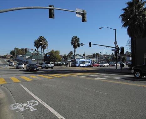
1 Ocean Park Boulevard Green Streets Project COMMENTS FROM COMMUNITY WORKSHOP 1: LISTENING / MARCH 3, 2008 I. SUMMARY OF COMMENTS This memorandum provides a summary and compilation of all the comments received at the March 3 Community Workshop. The order of the themes presented below is not prioritized but is simply a listing of clustered comments that provide a sense of the range of ideas expressed by the public on that Monday evening. The themes included those noted immediately below: 1. Enhance Walkability and Pedestrian Safety! 2. Emphasize Bikeability! 3. Slow Down Vehicular Traffic! 4. Improve Pedestrian Safety Around the School! 5. Address Traffic Issues at Highland Ave and Ocean Park Boulevard! 6. Address Traffic Issues at Lincoln Boulevard and Ocean Park Boulevard! 7. Address General Traffic Issues! 8. Redesign 4 th Street Overpass! 9. Emphasize the View from 4 th Street Overpass! 10. Provide Gateways, Landmarks, and Public Art! 11. Emphasize Environmental Sustainability! 12. Provide More and Better Greenery! 13. Beautify! 14. Enhance Bus Stops! 15. Address the Mural at Main Street and Ocean Park Boulevard! 16. Address Flooding at 5 th Street! Comments that did not fit the above themes or addressed areas of interest outside of a purely urban design scope are noted in an additional category presented below; Other General Comments. II. COMMENTS BY THEME 1. Enhance Walkability and Pedestrian Safety! Make the neighborhood for walking. Increase sidewalk width at strategic points along Ocean Park Blvd. Sidewalks along the ramps approaching 4 th Street are too narrow and impede walking. (David) Consider pedestrian bridges. (Dennis) Provide medians and green areas with crosswalks like in Portland. (Mary) Repair uneven sidewalk seams. Consider raised sidewalks. (Tony)
2 Ocean Park Boulevard Green Streets Project March 3, 2008 John Muir/SMASH The point along Ocean Park Boulevard where there are blinking lights to deter pedestrian crossing needs to be looked at from a safety perspective since people still cross there. (Hara) Widen sidewalks. They are too narrow for two-way pedestrian traffic! (2) Create more crosswalks designed like the one in front of City Hall that are safer for pedestrians. Put pedestrian striping at all crosswalks. A raised median would increase pedestrian safety, beautify the streetscape, and slow traffic speeds. Provide more crosswalk signage and flashing lights. Provide pedestrian bridges. (2) Provide pedestrian and bicycle crossing like at the beach (note: CAL Incline). 2. Emphasize Bikeability! Consider bicycle safety. (Frank) Bikes will become more and more prevalent. Build with bikes in mind. (Eric) The bike lanes along Ocean Park Boulevard are unsafe. Bike lanes physically separated from the road may not be the answer but the issue of bikes on Ocean Park Boulevard should be addressed. (Dennis) Talk to LA Bike Coalition and make it easier for traffic to coexist with cyclists. Bike lanes don t necessarily have to be separated from cars with green strip. Emphasize safety for bicycle travel! Separate bike lanes from cars for safety. Isolate bike lanes. Provide bike lanes and sidewalks as one not bike lanes on streets. Separate bike lanes with landscaped medians and integrate runoff mitigation measures. (3) 3. Slow Down Vehicular Traffic! Cars move too quickly along Ocean Park Boulevard. It s a neighborhood street! (Frank) Drivers heading westbound on Ocean Park Blvd make left turns onto 2 nd Street with too much speed. Drivers have run their cars into walls as well as a parked car at the intersection. (Tony) The intersection at Beverly Lane and Ocean Park Boulevard is dangerous. Westbound drivers approach at full speed. (Arthur) Vehicular speed and traffic volume are problematic. (Art) Provide a roundabout at Neilson Way. (Mary) Provide traffic circles. (Dennis) Slow traffic by integrating more curves and landscaping along the street. Chicane the street but perhaps not the bike lanes. Remember that this is a residential street and not a freeway. Provide a traffic circle at 3 rd Street and Ocean Park Boulevard. Increase enforcement of traffic laws. Stop or slow down or reduce overly fast turns from Ocean Park Boulevard onto southbound 2 nd Street and 3 rd Street. A narrower street section will slow down traffic. Slow traffic. 2
3 Ocean Park Boulevard Green Streets Project March 3, 2008 John Muir/SMASH 4. Improve Pedestrian Safety Around the School! Provide a pedestrian bridge at 5 th Street and Ocean Park Boulevard. Provide a crossing light at 5 th Street and Ocean Park Boulevard for children and pedestrians. Consider a traffic circle at 5 th and Ocean park Boulevard. The intersection is dangerous. Urgently install a pedestrian traffic signal at 5 th Street and Ocean Park Boulevard. Repeat urgently. Provide raised intersections at 5 th and 6 th Streets for pedestrian safety and to traffic calming. Provide safe crossing for school. Provide a pick-up and drop-off area at the school. (2) Add a four-way stop at 5 th Street and Ocean Park Boulevard. Provide a traffic circle at 5 th Street and Ocean Park Boulevard. Provide a traffic-calming roundabout at 5 th Street. Replace the signal at 6 th Street with a stop sign. 5. Address Traffic Issues at Highland Ave and Ocean Park Boulevard! Provide a crosswalk at Highland Ave. The intersection at Highland Ave is the highest point along Ocean Park Boulevard. Add a three-way stop sign there. Add a raised median/curb to prevent left turns at Ocean Park Boulevard and Highland Ave. 6. Address Traffic Issues at Lincoln Boulevard and Ocean Park Boulevard! Eastbound Ocean Park Boulevard as it approaches Lincoln Boulevard would work best if it were striped to allow a left turn lane, a through lane, and a right turn lane. The timing of the signal at Lincoln Boulevard and Ocean Park Boulevard sucks. The signal at Lincoln Boulevard requires a second wait. Provide a traffic light at 7 th street that is coordinated with Lincoln Boulevard to allow 7 th Street access. 7. Address General Traffic Issues! 3rd Street in the northbound direction at Ocean Park Blvd needs to be redesigned. Maintain Ocean Park Boulevard s ability to move traffic. Consider quiet asphalt along Ocean Park Blvd to reduce noise. (Jan) Density, traffic, and bigger cars are compromising neighborhood character. (Miriam) Provide a drop-off area at the school off Ocean Park Boulevard. Initiate a dialogue with the school soon. Take advantage of Prop BB. (Ted) Resolve access issues. Not being allowed to make left turns from Beverly Ave onto Ocean Park Boulevard is a huge inconvenience. (Marta) It is difficult to get to Lincoln Boulevard heading north from Beverly Ave. Drivers are required to make a left across Lincoln Boulevard traffic from Kensington or head towards the ocean on Ocean Park and make a U-turn t0 get back to Lincoln Boulevard. 3
4 Ocean Park Boulevard Green Streets Project March 3, 2008 John Muir/SMASH Restrict left turns to strategic points along Ocean Park Boulevard. 8. Redesign 4 th Street Overpass! Change the topography at 4 th Street to reduce slope. Close 4 th Street bridge. (Eric) Fill in the hill. (Dennis) The area over and under 4 th Street is awful and should be improved. Perhaps the underpass area can be lit up with solar powered lighting or receive other significant design treatment. (David) Getting onto Ocean Park Boulevard from side streets is dangerous. The ramps at 3 rd Street and 5 th Street are especially dangerous. (Judy) The layout of the west ramp from 4 th Street to 3 rd Street is awkward. (Tony) Left turns from the descending westbound ramp towards 3 rd Street at the westernmost stop sign is dangerous. (Tony) Provide sitting areas on the west side of 4 th Street. Provide lighting and sculpture under the 4 th Street bridge. Make the 4 th Street bridge wonderful. Turn the top of the 4 th Street overpass into a view point/vista point. Extend the structure on the west side to create additional space. Provide telescopes. Solar, back lighting on bridge. The murals have outlived their purpose. Preservation should not be a primary issue when deciding the final plan. 9. Emphasize the View from 4 th Street Overpass! Enhance access to ocean views. Celebrate our oceans. Provide viewing decks on 4 th Street overpass. Enhance access to the view from 4 th Street overpass. Beautify the overpass area. (Judy) Accentuate the view from the top of 4 th Street. (Dennis) The 4 th Street overpass feels blasted. Frame the ocean view as well as the view east. Provide benches. 10. Provide Gateways, Landmarks, and Public Art! Provide an iconic landmark in front of the school. (David) Gateway! Provide a gateway that announces that you ve entered Ocean Park. (Christine) Provide a welcoming sign to the Ocean Park District. (Tony) Emphasize historic nature of Ocean Park Blvd and Main Street intersection. (Roger) Provide better public art. (Jody) We should be utilizing the 1% developer fund to provide public art. (Roger) Create a gateway that welcomes people towards the sea. Provide a better school signage. Provide signage welcoming and pointing people to the beach. 11. Emphasize Environmental Sustainability! Provide drought tolerant plantings. 4
5 Ocean Park Boulevard Green Streets Project March 3, 2008 John Muir/SMASH The final Consensus Plan should reflect larger city policies and have a direct relationship to the city s sustainability goals. (Tracy) Provide community composting sites and/or community gardens. Specify which sustainable city plan goals this project will help meet. Turn 4 th Street bridge into a green bridge. Utilize permeable paving and/or recycled rubber sidewalks from Big Blue Bus tires. Provide native trees and sustainable landscaping and watering systems. Provide planted islands that serve as infiltration basins. 12. Provide More and Better Greenery! Don t cut down trees in the process. Provide edible gardens along Ocean Park Boulevard. (B.A) Reinforce the idea of having a signature street tree specie program to define the corridor. Palm trees can be iconic. (Scott) Provide real grass, not Astroturf. (Michael) Plant trees in empty tree wells. Provide medians with trees. Put in green center medians along Ocean Park Boulevard. Provide more trees along sidewalks. Green the medians along the entire boulevard. Provide more urban tree canopy. The ramps are awful! We need landscaping, new trees, and wide sidewalks. Provide center islands with landscaping. Provide street trees in the hatched areas of the street on the south side of Ocean Park Boulevard between 7 th Street and Highland Ave. Provide median strips with landscaping. Put in new trees. Provide more landscaping Canary Island Palms in medians as a gateway at Highland Ave. Create edible gardens. Turn parks along Ocean Park Boulevard into edible gardens. Use native and edible plants. Provide street trees in the hatched areas of the street on the south side of Ocean Park Boulevard between 7 th Street and Highland Ave. Consistent trees. Better trees. Close Ocean Park Boulevard and create a green space park. Acquire space at northwest corner at the intersection Main Street and Ocean Park Boulevard and create a park. The park at 6 th Street south of Ocean Park Boulevard can become an edible garden that provides for the school s salad bar. Turn parks along Ocean Park Boulevard into edible gardens. Provide median islands. 13. Beautify! Emphasize beauty when redesigning Ocean Park Boulevard. (Frank) Provide a street design that emphasizes a relationship with the ocean. (Mitchell) 5
6 Ocean Park Boulevard Green Streets Project March 3, 2008 John Muir/SMASH Ocean Park Boulevard is unusually ugly. We deserve better. (Mary) Provide streetlights that are beautiful as well as sustainable - solar-powered, with motion sensor. (Laura) The approach to Main Street should be made nicer. (Judy) Provide beautiful, solar-powered street lamps. 14. Enhance Bus Stops! Improve bus stops along Ocean Park Boulevard. (Jody) Improve the conditions around bus stops to enhance the waiting experience. (Frank) There are two major transit nodes along Ocean Park Boulevard: one at 2 nd Street and the other at 4 th Street. Buses that stop at 4 th Street can take you all the way to downtown. Take advantage of funds available for beautifying areas along transit corridors. (Frank) 15. Address the Mural at Main Street and Ocean Park Boulevard! Improve the mural at Ocean Park Boulevard and Main Street. (Hara) Force owners of mural wall at Main Street and Ocean Park Boulevard to restore or wipe-out that mural. Fix the mural at Main Street and Ocean Park Boulevard. Remove the mural at ZJ s. 16. Address Flooding at 5 th Street! Note that the area around the intersection at 5 th Street floods. The area was a pond in the past. Mitigate storm water runoff at 5 th Street and Ocean Park Boulevard. The property that the school sits on used to be a fishing pond. The structure is sinking due to this past. There is an ongoing lawsuit associated with this. Other General Comments: What is the difference between island and median? We need more police presence along Ocean Park Boulevard. (B.A) The park at the Public Library is substandard. It should be improved to enhance usability. (Scott) This project could bring the community together. Its cost is worth the improvement in the livability of the neighborhood and our quality of life. (David) City processes need to come to completion and be made more efficient. (Scott) JC Construction dumps left over cement from sidewalk work in tree soil and is killing and injuring trees. Replace the school with a gas station. Provide more places to sit. Keep two lanes and bike lanes. Synchronize traffic signals during high traffic times. Return Ocean Park Boulevard east of Lincoln Boulevard to four lanes. Relocate Angel s Attic. Try to remember that this is a residential street! There is no commercial here! Metro Bus now uses Ocean Park Boulevard between 2 nd Street and Main Street and no one to monitor. 6
7 Ocean Park Boulevard Green Streets Project March 3, 2008 John Muir/SMASH Use quieter buses/smaller buses. The park at 2 nd Street and Ocean Park Boulevard attracts homeless. Provide better lighting. Provide a monorail from Lincoln Blvd to Main Street. Traffic circles are dangerous. Note Strand and 4 th Street. Do not install medians along Ocean Park Boulevard as they slow emergency services. Add 24 hour parking along the entire length of Ocean Park Boulevard. The intersection of Beverly Ave and Hollister needs a stop sign. 7


8 LINCOLN BLVD Intersection at Ocean Park Boulevard and Main Street. HIGHLAND AVE BEVERLY LANE 04 View looking north towards 3rd and 4th Street. 03 View looking north at the overpass at 4th Street. 04 View looking south at the overpass at 4th Street. OCEAN PARK BLVD 4TH ST 4TH ST 05/06 3RD ST 3RD ST 03 2ND ST 2ND ST 05 View looking north from the top of the overpass at 4th Steet. MAIN ST MAIN ST NEILSON WAY NEILSON WAY 06 View looking east from the top of the overpass at 4th Street ft N PANORAMAS


9 LINCOLN BLVD View of SMASH/John Muir Elementary School at 5th Street. View of SMASH/John Muir Elementary School at 6th Street. 03 HIGHLAND AVE BEVERLY LANE View of linear park at Highland Ave & 6th Street. 04 View of linear park at Highland Ave & 6th Street. OCEAN PARK BLVD 4TH ST 4TH ST 3RD ST 3RD ST 2ND ST 2ND ST 05 View looking north towards Beverly Lane and Highland Avenue at 6th Street. 06 View looking south towards Highland Avenue and Beverly Lane at 7th Street MAIN ST MAIN ST NEILSON WAY NEILSON WAY 07 Intersection at Ocean Park Blvd and Lincoln Blvd ft N PANORAMAS


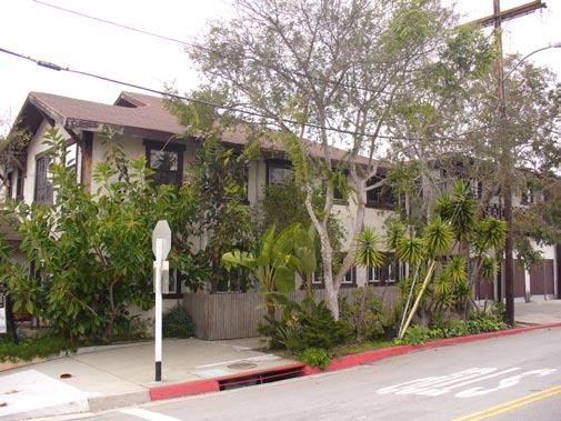
10 LINCOLN BLVD 14 Three-story commercial building on Main St and Ocean Park Blvd. Single-family residential building at 2nd Street. 03 Three-story multi-family residential building at 2nd Street. 04 Three-story multi-family residential building at 2nd Street. BEVERLY LANE HIGHLAND AVE Two-story multifamily residential building at 3rd Street. 06 Two-story multi-family residential building at 3rd Street. 07 Two-story multi-family residential building at 5th Street. 07 OCEAN PARK BLVD 4TH ST 4TH ST 06 3RD ST 3RD ST 05 03/04 2ND ST 2ND ST 08 SMASH Alternative School House at 5th Street. 09 Three-story multi-family residential building at Beverly Lane. 10 Three-story multi-family residential building at Highland Ave. 11 Two-story multifamliy residential building at 7th Street. MAIN ST MAIN ST NEILSON WAY NEILSON WAY 12 Two-story multi-family residential building at 7th Street. 13 Single-family residential building at 7th Street. 14 Commercial building at Lincoln Blvd ft N COMMUNITY CHARACTER


11 LINCOLN BLVD Crosswalk striping at east side of Main Street and Ocean Park Blvd. Crosswalk striping at north side of Main Street and Ocean Park Blvd. Crosswalk striping at south side of 3rd Street and Ocean 03 Park Blvd. 04 Crosswalk striping at southeast side of 3rd Street and Ocean Park Blvd. 13 HIGHLAND AVE BEVERLY LANE 05 Crosswalk striping at north side of 3rd Street and Ocean Park Blvd. 06 Crosswalk paving and stripes at west side of 4th Street and Ocean Park Blvd. 07 Crosswalk paving and stripes at south side of 4th Street and Ocean Park Blvd. 08 Crosswalk stripes at north side of 5th Street and Ocean Park Blvd. 08 OCEAN PARK BLVD 4TH ST 4TH ST /07 3RD ST 3RD ST 03 2ND ST 2ND ST 09 Crosswalk stripes at west side of 5th Street and Ocean Park Blvd. 10 Crosswalk stripes looking north at 5th Street and Ocean Park Blvd. 11 Crosswalk stripes looking west side at 6th Street and Ocean Park Blvd. 12 Crosswalk stripes at south side at 6th Street and Ocean Park Blvd. MAIN ST MAIN ST NEILSON WAY NEILSON WAY 13 Crosswalk stripes at north side at 7th Street and Ocean Park Blvd. 14 Crosswalk stripes looking northeast at Lincoln Blvd and Ocean Park Blvd. 15 Crosswalk stripes at west side of Lincoln Blvd and Ocean Park Blvd ft N CROSSWALKS


12 LINCOLN BLVD HIGHLAND A VE BEVERLY LANE TH ST 3RD ST 3RD ST 2ND ST ND ST MAIN ST 16 MAIN ST NEILSON WA Y CHARACTER NEILSON WA Y LANDSCAPE 4TH ST ft 500 N 07 OCEAN P ARK BLV D


13 LINCOLN BLVD BEVERLY LANE /04/06 12 HIGHLAND AVE 09/ OCEAN PARK BLVD 11 4TH ST 4TH ST 3RD ST 3RD ST ND ST 2ND ST MAIN ST MAIN ST NEILSON WAY NEILSON WAY ft N BUS / BIKE / OTHER


14 NEILSON WAY NEILSON WAY LINCOLN BLVD HIGHLAND AVE BEVERLY LANE OCEAN PARK BLVD 4TH ST 4TH ST 3RD ST 3RD ST 2ND ST 2ND ST MAIN ST MAIN ST Ocean Park Blvd. Task Force Consensus Plan

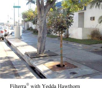

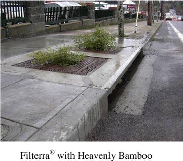
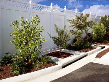
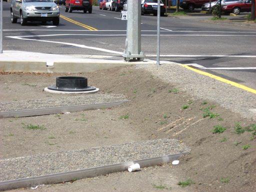
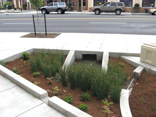
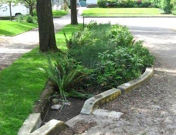
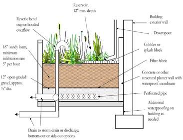
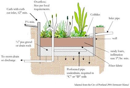
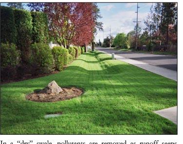
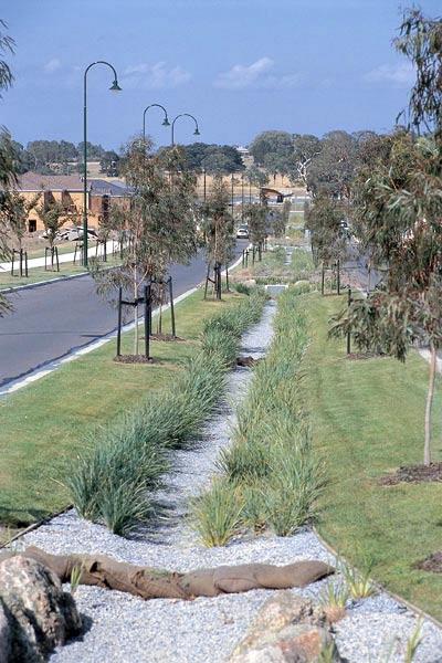
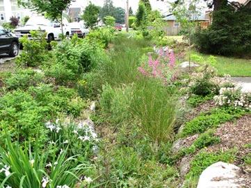
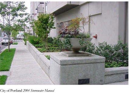
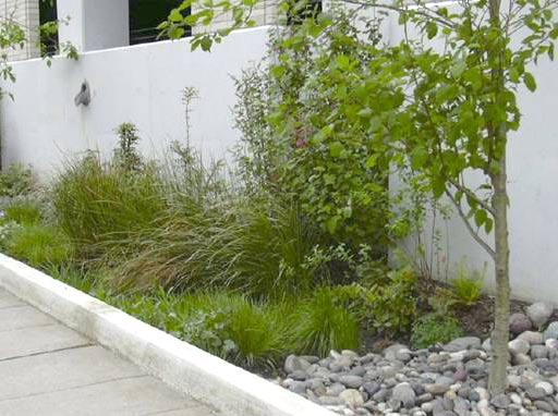
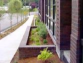
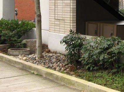
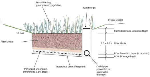
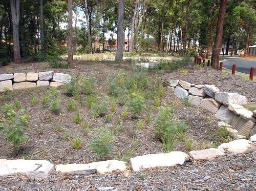
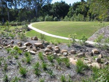
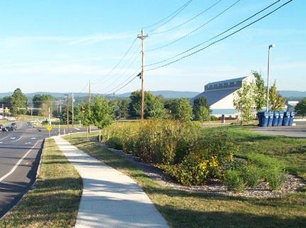

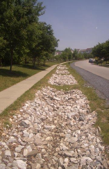
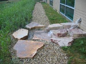
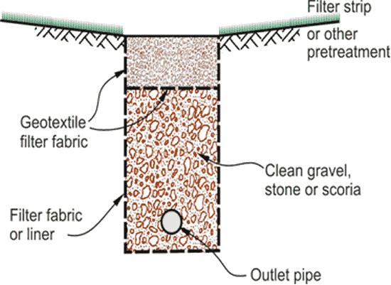
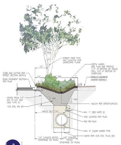
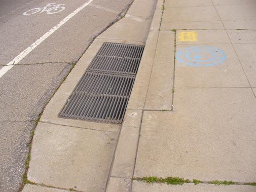
15 Filterra Stormwater Bioretention Filtration System Flow Through Planters In-Ground Planters Bioretention Basin Vegetated Swale Infiltration Trench 7.0 BEST MANAGEMENT PRACTICES
Ocean Park Boulevard Green Street Project Alternatives & Trade Offs
 Planning Commission March 4, 2009 Ocean Park Boulevard Green Street Project Alternatives & Trade Offs Purpose of Tonight s Meeting Review concept plans and options Provide input on alternatives and trade-offs
Ocean Park Boulevard Green Street Project Community Workshop
 Ocean Park Boulevard Green Street Project Community Workshop 2.2.10 Project Objectives Community Priority: reclaim OPB for public open space. Build upon LUCE principles; neighborhood enhancement, connectivity,
Ocean Park Boulevard Streetscape Improvement Project Alternatives & Trade Offs
 City Council Study Session January 27, 2009 Ocean Park Boulevard Streetscape Improvement Project Alternatives & Trade Offs Scope of Work Purpose of Tonight s Meeting Review work to date and direct staff
MARTIN LUTHER KING JR. WAY
 OCTOBER 2011 40 Vision and Goals The Martin Luther King, Jr. Way Illustrative Master Plan that follows has been developed through a process of community involvement. It expresses a long term vision for
City of Davis East Covell Corridor Plan
 Community Open House #2 January 22, 2014 6:00 8:00 p.m. Veterans Memorial Center, Club Room City of Davis Introduction The (ECCP) is a taking a comprehensive look at the existing transportation systems
Typical Cross Section: DOWNTOWN (Observer Highway - 8th Street)
") Typical Cross Section: DOWNTOWN (Observer Highway - 8th Street) DRAFT SEPTEMBER 23, 14 1 Washington Street Typical Block Downtown Typical Block: DOWNTOWN (Observer Highway - 8th Street) New crosswalks
Typical Cross Section: DOWNTOWN (Observer Highway - 8th Street) DRAFT SEPTEMBER 23, 14 1 Washington Street Typical Block Downtown Typical Block: DOWNTOWN (Observer Highway - 8th Street) New crosswalks
Lawrence Avenue Streetscape Concepts August 30, 2011
 Lawrence Avenue Streetscape Concepts August 30, 2011 Neighborhood Context Phase II: River to Western Ave. Phase I: Western Ave. to Clark St. Key Map Lawrence Ave. Existing Streetscape Conditions East of
MAKE YOUR PLACE IN CHANNELSIDE
 MAKE YOUR PLACE IN CHANNELSIDE INTRODUCTION PROJECT LIMITS Channelside Drive from Cumberland Ave to Kennedy Boulevard EXISTING CONDITIONS EXISTING CONDITIONS CHANNELSIDE DRIVE FROM E. CUMBERLAND AVENUE
5 CIRCULATION AND STREET DESIGN
 5 CIRCULATION AND STREET DESIGN This chapter describes circulation and streetscape improvements proposed for the Northwest Chico Specific Plan Area. It includes detailed design specifications for existing
FOCUS AREA 1 - Alberta Avenue Pocket Park 3 (121 Ave and 92 St)
") FOCUS AREA 1 - Alberta Avenue Pocket Park 3 (121 Ave and 92 St) New benches Plant evergreen trees Widen existing sidewalk from 1.5m to 1.8m Marked crosswalk 1.8m wide sidewalk Add pedestrian oriented lights
FOCUS AREA 1 - Alberta Avenue Pocket Park 3 (121 Ave and 92 St) New benches Plant evergreen trees Widen existing sidewalk from 1.5m to 1.8m Marked crosswalk 1.8m wide sidewalk Add pedestrian oriented lights
Appendix C. TRAFFIC CALMING PROGRAM TOOLBOX
 Appendix C. TRAFFIC CALMING PROGRAM TOOLBOX PHASE I...2 Do Not Enter Sign...3 One-Way Sign...4 Turn Prohibition...5 Pavement Markings...6 Speed Monitoring Trailer...7 Neighborhood Speed Watch...8 Police
Victoria Park Master Plan
 Victoria Park Master Plan Phase I Presented By: ARCHITECTURAL ALLIANCE & HUGHES HUGHES INC. History of Victoria Park Phase I Purpose Inventory of Existing Conditions Identification of Options by Type (for
Tonight is for you. Learn everything you can. Share all your ideas.
 Strathcona Neighbourhood Renewal Draft Concept Design Tonight is for you. Learn everything you can. Share all your ideas. What is Neighbourhood Renewal? Creating a design with you for your neighbourhood.
A CHANGING CITY. of Edmonton, it is essential that it reflects the long-term vision of the City.
 A CHANGING CITY By the year 2040, Edmonton will be home to more than 1 million people. To accommodate growth and support a healthy and compact city, we need a new approach to development/redevelopment
Safe Routes to School Action Plan Aberdeen, Idaho
 Background Aberdeen, Idaho is a largely agricultural community of nearly 2,000 people and is located in the southeast portion of the state on the western edge of American Falls Reservoir. The community
Design Guidelines. Overview. Design Vision for Yellow Brick Road
 Design Guidelines Overview This section presents the design vision for the Yellow Brick Road network. The Yellow Brick Road is envisioned to be an interconnected network of safe and secure roadways where
ROUTE 81 CORRIDOR STUDY DESIGN CONCEPTS
 RT 81 Corridor Study CLINTON ROUTE 81 CORRIDOR STUDY DESIGN CONCEPTS View north on High Street, with potential improvements to the streetscape Draft Recommendations November 8 th, 2018 TOWN OF CLINTON
COWETA HIGH SCHOOL AND EAST HIGHWAY 51
 COWETA HIGH SCHOOL AND EAST HIGHWAY 51 Lack of sidewalks along Ben Lumpkin Rd. Lack of crosswalks and ramps at intersection. Hwy 51 is wide to cross as a pedestrian. No ADA compliance or connection to
El Camino Real Specific Plan. TAC/CAC Meeting #2 Aug 1, 2018
 El Camino Real Specific Plan TAC/CAC Meeting #2 Aug 1, 2018 Land Use Alternatives Goals and Tradeoffs Parks & open space Housing Retail & services Civic spaces Parking Community gathering spaces 3 Alternatives
TRANSPORTATION STANDARDS
 INTRODUCTION LOCAL STREETS ON-STREET PARKING SIDEWALKS STREET LIGHTING STREET FURNISHINGS TRAFFIC CALMING STREET TREES MEDIAN PLANTING BOULEVARD LOCATIONS VILLAGE CENTER STREET LOCATIONS RESIDENTIAL STREET
Make Lincoln Highway an economically vibrant corridor that is safe, efficient, and beautiful for local residents and visitors.
 Lincoln Highway Streetscape Plan Stakeholder Workshop #2 Handout Contents Introduction and Project Vision Planning Principles Specific Recommendations including a Proposed Typical Roadway Section Renderings
Agenda. Overview PRINCE GEORGE S PLAZA METRO AREA PEDESTRIAN PLAN
 PRINCE GEORGE S PLAZA METRO AREA PEDESTRIAN PLAN May 28, 2008 Agenda Welcome and introductions Project overview and issue identification Planning context and strengths Design challenges and initial recommendations
Observations and Ideas: Toomer s Corner Streetscape Improvements
 Observations and Ideas: Toomer s Corner Streetscape Improvements AUBURN DOWNTOWN MASTER PLAN planning downtown s future August 26, 2013 Observations: Vertical Clutter at Corners 6 3 7 5 9 2 8 4 1 Excess
Bicycle and Pedestrian Advisory Committee (BPAC) November 21, 2013
 November 21, 2013") Bicycle and Pedestrian Advisory Committee (BPAC) November 21, 2013 OVERALL LAND USE CONCEPT Overall Broadway Valdez District: 95.5 acres (35.1 acres right-of ways + 60.4 acres developable land) Plan Subareas:
Bicycle and Pedestrian Advisory Committee (BPAC) November 21, 2013 OVERALL LAND USE CONCEPT Overall Broadway Valdez District: 95.5 acres (35.1 acres right-of ways + 60.4 acres developable land) Plan Subareas:
CAPITOL DRIVE & FOND DU LAC AVENUE INTERSECTION ANALYSIS. Urban Planning 772 SARAH BREGANT, RYAN PETERSON, & MATT WERDERITCH
 CAPITOL DRIVE & FOND DU LAC AVENUE INTERSECTION ANALYSIS Urban Planning 772 SARAH BREGANT, RYAN PETERSON, & MATT WERDERITCH OVERVIEW N 51 ST BOULEVARD N 51 ST BOULEVARD 12,100 44,700 W CAPITOL DRIVE 52,600
Complete Streets. Designing Streets for Everyone. Sarnia
 Complete Streets Designing Streets for Everyone Sarnia Complete Streets ~ Sarnia ~ 2018 Introduction Our City is made up of a network of streets that we use to go for a walk, cycle to work, drive to the
5. Automobile Circulation, Wayfinding and Signage
 5. Automobile Circulation, Wayfinding and Signage Policy: The City Center should have a balanced, safe, and interconnected circulation system that provides expanded travel opportunities for transit, pedestrian,
Transportation Planning Division
 Transportation Planning Division Presentation Outline Study Tasks Recap of Previous Meetings Data Collected Focus Areas within Study Limits Design Principles Tool Box Recommended Concepts Schedule Moving
UPTOWN REGIONAL BIKE CORRIDORS PROJECT SAN DIEGO ASSOCIATION OF GOVERNMENTS
 UPTOWN REGIONAL BIKE CORRIDORS PROJECT SAN DIEGO ASSOCIATION OF GOVERNMENTS SUMMARY REPORT: COMMUNITY UPDATE MEETING February 6, 2014 6 8:30 p.m. Roosevelt Middle School Library 3366 Park Blvd, San Diego
PUBLIC REALM MASTER PLAN
 WESTSHORE BUSINESS DISTRICT PUBLIC REALM MASTER PLAN MASTER PLAN COMMITTEE MEETING MARCH 20, 2013 WESTSHORE BUSINESS DISTRCT PUBLIC REALM MASTER PLAN MACRO-SCALE CONCEPT: A PUBLIC REALM FRAMEWORK DEFINED
Vision: Traditional hamlet with an attractive business/pedestrian friendly main street connected to adjacent walkable neighborhoods
 N D. Focus Area II Vision: Traditional hamlet with an attractive business/pedestrian friendly main street connected to adjacent walkable neighborhoods Transit Road Focus Area II is located in the Hamlet
PRINCE GEORGE S PLAZA METRO AREA PEDESTRIAN PLAN
 PRINCE GEORGE S PLAZA METRO AREA PEDESTRIAN PLAN May 28, 2008 Agenda Welcome and introductions Project overview and issue identification Planning context and strengths Design challenges and initial recommendations
Caltrans Sloat Boulevard Pedestrian Safety Project Response to Community Questions, Comments & Concerns
 Caltrans Sloat Boulevard Pedestrian Safety Project Response to Community Questions, Comments & Concerns Revised: May 10, 2016 The California Department of Transportation (Caltrans) is planning various
THE ALAMEDA CONCEPT DESIGN COMMUNITY MEETING 3. A Plan for The Beautiful Way JANUARY 28, 2010
 CONCEPT DESIGN COMMUNITY MEETING 3 JANUARY 28, 2010 AGENDA INTRODUCTION COMMUNITY INPUT ROADWAY STUDIES STREETSCAPE DESIGN STATIONS DISCUSSION SUMMARY AND DISCUSSION NEXT STEPS CLOSE INTRODUCTION SCHEDULE
Omaha s Complete Streets Policy
 Omaha s Complete Streets Policy (Adopted August 2015) VISION To create great places and enhance our quality of life, the City of Omaha will provide safe, accessible streets for all users. Complete Streets
Section 7 Complete Green Street Guidelines DRAFT
 Section 7 Complete Green Street Guidelines DRAFT 1 Section: 7.0 COMPLETE GREEN STREET GUIDELINES These guidelines serve as options to mitigate the environmental impact of a project as well as guide the
Community Transportation Plan
 Community Transportation Plan Appendix A: Traffic Calming CITY OF DECATUR COMMUNITY TRANSPORTATION PLAN Appendix A: City of Decatur City-wide Residential Traffic Calming Program Process & Procedures The
2014/2015 BIKE ROUTE PLAN 83 AVENUE PROTECTED BIKE LANE
 About the Project The City of Edmonton is planning a major bike route on the southside of Edmonton. The Strathcona Bike Route will connect the communities of Strathcona, Garneau and the University area,
Clarkson Walkability Audit: Results and Recommendations Summary
 Clarkson Walkability Audit: Results and Recommendations Summary The following document was prepared by the Region of Peel and includes a summary of comments made by participants during our breakout discussion
4 GENERIC COST ESTIMATING TOOL
 4 GENERIC COST ESTIMATING TOOL Table 4-1 presents a generic cost estimating tools that can serve as a conceptual planning tool for local jurisdictions to estimate the costs of pedestrian improvements.
Community Meeting February 27, 2007 Dorchester Avenue Transportation & Streetscape Improvements Action Plan February 27, 2007
 Community Meeting Tonight s Agenda 6:00 Introductions South Boston/Dot Ave Improvement Study Background 6:15 Consultant Introductions Review of Scope and Schedule Review of Proposed Corridor Wide Guidelines
2016 I-30 CROSSING ARKANSAS BOULEVARD KEY IDEAS OF PLAN B:
 KEY IDEAS OF PLAN B: Transportation shall support all parts of the cities and improve the quality of life downtown. There is no need to shorten commuting time at rush hour by a few minutes at the risk
STREETSCAPE CONCEPT PLAN
 03 STREETSCAPE CONCEPT PLAN Zone 1 This zone includes the gateway into both the downtown and the Village at Harlem. The gateway features are shown closer to the Harlem intersection to make them more prominent.
Miami Health District
 Miami Health District Streetscapes, Gateways, and Signage Basis of Design Report Study Miami Partnership Meeting July 21, 2008 Gannett Fleming EDAW The Corradino Group Sponsored by the Miami Partnership:
Welcome to the Quebec Alternatives Analysis Public Meeting
 Welcome to the Public Meeting Please sign in. Public Comment Please fill out a comment card and tell us what you think. Check back or comment any time at: www.quebecalternatives.com Project Area Technical
City of Seattle Edward B. Murray, Mayor
 City of Seattle Edward B. Murray, Mayor Department of Transportation Scott Kubly, Director Eastlake Community Council 117 E Louisa St. #1 Seattle, WA 98102-3278 January 28, 2016 RE: Roosevelt to Downtown
Mission-Geneva Transportation Study Community Workshop 2 July 8, 2006
 Community Workshop 2 July 8, 2006 Small Group Workbook 1 Basic Improvements on Mission Street Streetscape. Pedestrian-scale lighting; landscaping; community art on utility boxes; more (possibly unique)
Dec 2, Dear Tri Ong, Sam Woods, and Scott Kubly,
 Dec 2, 2014 Dear Tri Ong, Sam Woods, and Scott Kubly, Thank you for providing us with the 2015 Arterial Asphalt and Concrete (AAC) repaving project 60% plan for Roosevelt Way NE. It's exciting to see the
HARRISON STREET/OAKLAND AVENUE COMMUNITY TRANSPORTATION PLAN
 HARRISON STREET/OAKLAND AVENUE Community Workshop #4: Draft Plan Review December 3, 2009 D E S I G N, C O M M U N I T Y & E N V I R O N M E N T INTRODUCTIONS Key Project Staff: Alisa Shen, Project Manager,
Lincoln Neighborhood Corridor Plan The LiNC
 CITY OF SANTA MONICA Lincoln Neighborhood Corridor Plan The LiNC PLANNING COMMISSION September 2, 2015 COMMUNITY DESIGN + ARCHITECTURE TEAM: Community Design + Architecture Iteris Studio 111 Urban Place
Brooklyn Boulevard (County Road 152) Reconstruction Project Phase I. OPEN HOUSE June 20, 2017
 Reconstruction Project Phase I. OPEN HOUSE June 20, 2017") Brooklyn Boulevard (County Road 152) Reconstruction Project Phase I OPEN HOUSE June 20, 2017 Brooklyn Boulevard (County Road 152) Phase I Project Partners Project Lead Other Project Partners include Brooklyn
Brooklyn Boulevard (County Road 152) Reconstruction Project Phase I OPEN HOUSE June 20, 2017 Brooklyn Boulevard (County Road 152) Phase I Project Partners Project Lead Other Project Partners include Brooklyn
Austin Avenue Bridges Project. Public Meeting Summary
 Austin Avenue Bridges Project Public Meeting Summary June 29, 2016 Red Table Safety and Connectivity Notes: 1. Would like to see forensic report evaluations 2. What is the lifespan? 3. Extend safety considerations
Summary: Mercer County Princeton Avenue & Spruce Street Study January 2009
 Summary: Several recent studies have assessed potential development and redevelopment opportunities in the Mercer Crossing area of Trenton, Ewing, and Lawrence. This Princeton Avenue and Spruce Street
Broad Street Bicycle Boulevard Design Guidelines
 Broad Street Bicycle Boulevard Design Guidelines Building from the strategies introduced in the 2013 Bicycle Transportation Plan and community input received thus far, City Transportation Staff have identified
Traffic Signal Phasing Study Summary & Staff Recommendations
 Traffic Signal Phasing Study Summary & Staff Recommendations Consultant Study by Skipper Consulting, Inc. Staff Committee Recommendations by Randy Pewitt, Executive Director of Emergency Mgt. and Safety
Walkability Audit Cities of Olympia, Tumwater and Lacey, Washington. Next Steps Memorandum September FINAL
 Walkability Audit Cities of Olympia, Tumwater and Lacey, Washington Memorandum September 2012 - FINAL 1. INTRODUCTION The U.S. Environmental Protection Agency (EPA) selected the Thurston Regional Planning
TRAFFIC ACTION PLAN. Laurie Meadows Neighborhood CITY OF SAN MATEO
 TRAFFIC ACTION PLAN Laurie Meadows Neighborhood CITY OF SAN MATEO Draft January 2017 Table of Contents Introduction... 2 The Traffic Forum Process... 5 Neighborhood Traffic Issues... 7 Neighborhood Recommendations
CONNECTIVITY PLAN. Adopted December 5, 2017 City of Virginia Beach
 CONNECTIVITY PLAN Adopted December 5, 2017 City of Virginia Beach CONTENTS 1.0 Background & Purpose... 2 2.0 Existing Inventory & Analysis... 3 ViBe District Existing Walking Conditions... 4 3.0 ViBe District
Safe Routes to School: Munroe Elementary Walk Audit Report. Image: Drexel, Barrell & Co.
 Safe Routes to School: Munroe Elementary Walk Audit Report Image: Drexel, Barrell & Co. April 12, 2016 OVERVIEW As part of the 2014/2015 Denver Safe Routes to School (SRTS) Program, WalkDenver coordinated
2014/2015 BIKE ROUTE PLAN 83 AVENUE PROTECTED BIKE LANE
 About the Project 2014/2015 BIKE ROUTE PLAN The City of Edmonton is planning a major bike route on the south side of Edmonton. This bike route is one part of a plan to provide citizens with transportation
14 TH STREET TRANSPORTATION & STREETSCAPE DESIGN STUDY PLAN B PLAN B TRANSPORTATION & STREETSCAPE RECOMMENDATIONS
 14 TH STREET TRANSPORTATION & STREETSCAPE DESIGN STUDY PLAN B PLAN B TRANSPORTATION & STREETSCAPE RECOMMENDATIONS 141 Symbols Recommendations - Southern End of 14th Street Study Area Streetscape Each icon
COMMUNITY MEETING #1 Summary
 COMMUNITY MEETING #1 Summary October 26, 2016 LOCATION: TIME: ATTENDEES: Dr. Phillips High School Cafeteria 6500 Turkey Lake Road, Orlando, FL 32819 6:00 pm to 8:00 pm 79 citizens Commissioner Scott Boyd,
Draft North Industrial Area-Wide Traffic Plan
 Summary of North Industrial and Hudson Bay Industrial Recommended Improvements Table 1. Summary of s Item Location 1 2 3 4 5 6 7 8 9 10 11 12 Millar Ave north of 51st St Super 8 Motel back lane 400 Block
Report on Walkability Survey and Workshop for ZIP Code Hosted by the Oklahoma City-County Health Department April 13, 2013
 Report on Walkability Survey and Workshop for ZIP Code 73111 Hosted by the Oklahoma City-County Health Department April 13, 2013 On April 13th, the Oklahoma City-County Health Department hosted a community
Board-Approved Funding Awards for Cycle 4 Active Transportation Grant Program Projects (in Order of Project Rankings) Approved on
 Approved on") CAPITAL Large Category Projects Board-Approved Funding Awards for Cycle 4 Active Transportation Grant Program Projects (in Order of Project Rankings) Approved on 07-27-18 1 La Mesa University Ave Pedestrian
CAPITAL Large Category Projects Board-Approved Funding Awards for Cycle 4 Active Transportation Grant Program Projects (in Order of Project Rankings) Approved on 07-27-18 1 La Mesa University Ave Pedestrian
The Wiggle Route in Context
 The Wiggle Route in Context In a city of hills, the Wiggle is an important route because it winds its way along the flattest streets from Market to the Panhandle, bringing residents to local parks and
Display Boards Including Five Refined Design Concepts
 APPENDIX D Workshop Session 3 Sign-in sheets Agenda Booklet Display Boards Including Five Refined Design Concepts PowerPoint Presentation Questions Recorded Discussion of Preference Exercise AGENDA
Bicycle Boulevards and Neighborhood Greenways
 Bicycle Boulevards and Neighborhood Greenways Traffic Safety is Improving for Everyone 90 80 70 60 50 40 30 20 10 0 PORTLAND: TOTAL TRAFFIC FATALITIES 1986-2008 1986 1987 1988 1989 1990 1991 1992 1993
Safe Streets. City of Lake Forest Park. March 21, 2017
 Safe Streets City of Lake Forest Park March 21, 2017 1 01 WELCOME 2 Agenda WELCOME WHAT IS THIS PROJECT? CONTEXT DRAFT CITYWIDE PROJECTS EXERCISE INTRODUCTION 3 02 WHAT IS THIS PROJECT? 4 WHAT IS THIS
Bridges and Arizona Crossings
 Circulation and Transportation 5-11 Discovery Street/Barham Drive. Discovery Street is planned 5.4.3 Specific Plan Circulation Improvements to be extended eastward from its terminus at Craven Road Circulation
WELCOME. Thank you for joining us at the Second Public Workshop for the Carlsbad Pedestrian Master Plan. We look forward to receiving your feedback.
 City of Carlsbad Pedestrian Master Plan: WELCOME WELCOME Please Sign In Provide Input at Flip Charts Review Boards Presentation of Draft Plan Thank you for joining us at the Second Public Workshop for
Transportation Corridor Studies: Summary of Recommendations
 Transportation Corridor Studies: Summary of Recommendations Route 4 Corridor Study: Route 10 Corridor Study: Route 44 Corridor Study: Route 175 Corridor Study: Route 5/15 Corridor Study: Rentschler Field
WalkShop. Highland Creek Village
 On June 5, 2014, 15 people participated in a for the Transportation Master Plan. The purpose of the was to receive feedback from a diverse range of local stakeholders and document existing transportation
122 Avenue: 107 Street to Fort Road
 : 107 Street to Fort Road November 24, 2015 4:30 8:00 p.m. Meeting Purpose Summarize project work completed to date Share results of public input from Phase 1 Share the draft concept plan and proposed
Figure 4-10: Pedestrian Improvements Types of Potential Station Area Improvements - Place-Making Improvements
 INCORPORATE FEATURE PAVIN IN CROSSWALK AND INTERSECTION FIELDS Identifies high-priority pedestrian areas and create a station identity through colorful and interesting patterns ADD CURB EXTENSIONS Extending
Bikeway action plan. Bicycle Friendly Community Workshop March 5, 2007 Rochester, MN
 Bikeway action plan Summary The was held on March 5, 2007 at the Rochester Mayo Civic Center. The workshop was hosted by Rochester-Olmsted County Planning Department in collaboration with the League of
Paoli Road Improvement Feasibility Study
 Paoli Road Improvement Feasibility Study & Public Participation Project March 24, 2015 Prepared for: Tredyffrin Township Prepared by: McMahon Associates, Inc. with Town Planning Partnership, LLC Glackin
DEPARTMENT OF ENVIRONMENTAL SERVICES. North Harrison Street (Lee Highway to Little Falls Road) Comparative Analysis. Prepared for:
 Comparative Analysis. Prepared for:") DEPARTMENT OF ENVIRONMENTAL SERVICES North Harrison Street (Lee Highway to Little Falls Road) Comparative Analysis Prepared for: Arlington County Department of Environmental Services 2100 Clarendon Boulevard,
DEPARTMENT OF ENVIRONMENTAL SERVICES North Harrison Street (Lee Highway to Little Falls Road) Comparative Analysis Prepared for: Arlington County Department of Environmental Services 2100 Clarendon Boulevard,
Active Transportation Rail to River Corridor. Community Meeting - Segment A
 Active Transportation Rail to River Corridor Community Meeting - Segment A June 29, 2017 Tonight s Agenda > Open House (30 min) > Welcome / Project Overview > Presentation of 30% Design Refinements > Next
Lincoln Highway Streetscape Plan Concept Plan
 Lincoln Highway Streetscape Plan Concept Plan November 14, 2014 Introduction This report provides a summary of conceptual transportation, land use, and design recommendations in the Lincoln Highway Streetscape
The Leadville Bikeway Design Recommendations DRAFT January 2018
 The Leadville Bikeway Design Recommendations DRAFT January 2018 Overview The Leadville Bikeway project aims to create a bikeway that is compatible with and adds value to the neighborhood and surrounding
Chapter 3: Multi-Modal Circulation and Streetscapes
 CHAPTER 3: MULTI-MODAL CIRCULATION AND STREETSCAPES Chapter 3: Multi-Modal Circulation and Streetscapes Overview Streetscape improvements have already been completed for Depot Street between Main Avenue
Report. Typical Sections. City of Middleton, WI
 Report Typical Sections City of Middleton, WI December 2006 Report for City of Middleton, Wisconsin Typical Sections repared by: Traffic Associates LLC and STRAND ASSOCIATES, INC. 910 West Wingra Drive
COMMENT CARD SUMMARY
 NORTH PARK MID-CITY REGIONAL BIKE CORRIDORS PROJECT SAN DIEGO ASSOCIATION OF GOVERNMENTS COMMUNITY ADVISORY GROUP MEETING 1 January 30, 2013 6:00 p.m. 8:30 p.m. City Heights Wellness Center 4440 Wightman
MASONIC AVENUE STREET DESIGN STUDY Community Workshop 2. Masonic Ave Street Design Study Community Workshop 2 August 10, 2010
 Masonic Ave Street Design Study Community Workshop 2 August 10, 2010 Introduction MASONIC AVENUE STREET DESIGN STUDY Community Workshop 2 SF Municipal Transportation Agency Javad Mirabdal, Project Manager
Safe Routes to School: Valverde Elementary Walk Audit Report. Image: CPLIVE, SkyscraperPage.com
 Safe Routes to School: Valverde Elementary Walk Audit Report Image: CPLIVE, SkyscraperPage.com April 28, 2016 1 OVERVIEW As part of the 2014/2015 Denver Safe Routes to School (SRTS) Program, WalkDenver
SURVEY minutes to complete this questionnaire. Your feedback will help the City determine a future design for Ocean Avenue and Geneva Avenue. Thanks!
 OCEAN AVENUE CORRIDOR DESIGN ROJECT WORSHO #4 Thank you for your interest in the Ocean Avenue Corridor Design project. lease take a few SURVEY minutes to complete this questionnaire. Your feedback will
San Jose Transportation Policy
 San Jose Transportation Policy Protected Intersections in LOS Policies to Support Smart Growth Presented by: Manuel Pineda City of San Jose Department of Transportation Bay Area Map San Francisco Oakland
Southbend to Prima Vista. October 30, Floresta Corridor Master Plan
 Application of a Complete Street initiative and how it might function operationally 8 8 Southbend to Prima Vista October 30, 2017 Presentation Agenda 2 Perspective and History Traffic projections, Levels
Chicago Safe Routes to School Safe Routes to High School (SRTS/SRTHS)
") Chicago Safe Routes to School Safe Routes to High School (SRTS/SRTHS) Marshall Community High School and Faraday Elementary School Recommended Improvements Agenda Goals Related Programs Project Location/Area
Chicago Safe Routes to School Safe Routes to High School (SRTS/SRTHS) Marshall Community High School and Faraday Elementary School Recommended Improvements Agenda Goals Related Programs Project Location/Area
ALBERTA AVENUE WHAT WE HEARD REPORT BUILDING GREAT NEIGHBOURHOODS
 ALBERTA AVENUE WHAT WE HEARD REPORT BUILDING GREAT NEIGHBOURHOODS FEBRUARY 2019 EXECUTIVE SUMMARY Starting in 2019, Alberta Avenue will see the replacement and enhancement of its aging collector and local
NEWMARKET UPHAM S CORNER
 SOUTH STATION Planning Initiative NEWMARKET UPHAM S CORNER COLUMBIA ROAD (P) FOUR CORNERS/GENEVA Working Advisory Group (WAG) Meeting #5 TALBOT AVENUE MORTON STREET BLUE HILL AVE/CUMMINS HWY (P) RIVER
50 Avenue S.W. Corridor Study Glenmore Aquatic Centre Drop-In Event
 Project overview The City of Calgary is conducting a transportation corridor study of 5 Avenue S.W., between Crowchild Trail and 4A Street S.W. In 29, it was reclassified as a Parkway under the Calgary
25th Avenue Road Diet Project A One Year Evaluation. Transportation Fund for Clean Air Project #05R07
 25th Avenue Road Diet Project A One Year Evaluation Transportation Fund for Clean Air Project #05R07 Submitted by: The San Francisco Municipal Transportation Agency Dan Provence May 22, 2009 EXECUTIVE
Neighborhood Analysis & Improvement Ideas. El Montevideo Neighborhood
 Neighborhood Analysis & Improvement Ideas El Montevideo Neighborhood El Montevideo Neighborhood Neighborhood Analysis & Improvement Ideas Drachman Institute College of Architecture and Landscape Architecture
Introduction. North 12 th Complete Street Project Overview
 Introduction On Wednesday, March 1, 2017, the City of Sacramento, in partnership with Sacramento Regional Transit District and the Sacramento Housing and Redevelopment Agency, hosted a community outreach
Table #6 VISION CHARACTERISTICS
 Table #6 VISION White Flint is a place to live, work, play, shop, and walk with sufficient density to encourage quality redevelopment. Vibrant streets and consistent streetscapes are important. CHARACTERISTICS
APPENDIX A: Complete Streets Checklist DRAFT NOVEMBER 2016
 APPENDIX A: Complete Streets Checklist DRAFT NOVEMBER 2016 Complete Streets Checklist MetroPlan Orlando s Complete Streets Checklist is an internal planning tool for staff to further implementation of
STONY PLAIN ROAD STREETSCAPE
 Jasper Place Revitalization Strategy: Vision The people involved in the Jasper Place Revitalization Strategy envision: Goal 1: Feeling safe in our community Create a community where feeling safe is common--where
CRESTON ROAD COMPLETE AND SUSTAINABLE STREETS CORRIDOR PLAN
 CRESTON ROAD COMPLETE AND SUSTAINABLE STREETS CORRIDOR PLAN Preferred Plan Community Presentation September 27, 2017 City of El Paso de Robles in partnership with: Local Government Commission, W-Trans,