CITY OF LOS ANGELES INTER-DEPARTMENTAL CORRESPONDENCE
|
|
|
- Theodora Phelps
- 5 years ago
- Views:
Transcription
1 FORM GEN. 160A (Rev. 1/82) CITY OF LOS ANGELES INTER-DEPARTMENTAL CORRESPONDENCE 8150 W. Sunset Bl DOT Case No. CEN Date: July 26, 2016 To: Karen Hoo, City Planner Department of City Planning From: Subject: Wes Pringle, Transportation Engineer Department of Transportation UPDATED TRANSPORTATION ANALYSIS FOR THE PROPOSED MIXED- USE PROJECT LOCATED AT 8150 WEST SUNSET BOULEVARD On February 28, 2014, the Department of Transportation (DOT) issued a traffic assessment report to the Department of City Planning regarding a proposed mixed-use project located at 8150 West Sunset Boulevard. However, since the report was released, the project description has been modified and an updated traffic analysis was prepared that assesses the applicability of the results and findings of the original traffic impact analysis prepared in November Therefore, DOT has prepared this traffic impact assessment report and has updated the original project requirements to be consistent with current City and DOT policies. Please replace the previous DOT assessment with this report DOT has reviewed the updated traffic analysis included in the project s environmental documents for the project scenario referred to as Alternative 9. The analysis, dated December 10, 2015, was prepared by Hirsch/Green Transportation Consulting for the mixedused project proposed on the southwest corner of Crescent Heights Boulevard and Sunset Boulevard. The project was the subject of a traffic analysis dated November 2013 and of a DOT report dated February 28, The original study analyzed 15 intersections: four in the City of Los Angeles and 11 in the City of West Hollywood. The traffic study determined that none of the study intersections would be significantly impacted by project related traffic in the City of Los Angeles. The project would result in one potential significant impact at an unsignalized intersection in the City of West Hollywood. The revised project proposes the same number of residential units, a decrease in the size of the retail use, and the removal of the driveway on Sunset Boulevard. The revised project is not expected to result in any changes to the original significant traffic impacts. The purpose of the updated analysis is to assess the relevance of the original traffic study prepared in 2013 and to evaluate the effect that the changes in the proposed development would have on the findings of the original traffic study. The updated traffic analysis identifies the revised land use proposal, describes changes to the project s site access and circulation plan, and updates the project trip generation estimates. DOT concurs with the results of the updated analysis, which accounted for other known development projects in evaluating potential cumulative impacts, that the revised project would not result in any new significant traffic impacts. The results for the revised analysis are summarized in Attachment 1.
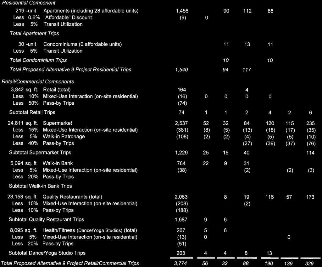
2 Karen Hoo -2- July 26, 2016 DISCUSSION AND FINDINGS A. Project Description The table below compares the land use descriptions between the original and revised project scopes. The revised project would increase the residential portion and decrease the retail space, as follows: Land Use Original Project Revised Project Residential 249 Apartment Units (including 28 affordable) Condominiums 0 Units 30 Units Retail 51,150 SF 3,842 SF Supermarket 24,811 SF 24,811 SF Walk-In Bank 5,094 SF 5,094 SF Restaurant 28,189 SF 23,158 SF Dance/Yoga Studio 249 Apartment Units (including 28 affordable) 8,095 SF 8,095 SF The original project indicated that vehicular access to the site would be provided by driveways on Crescent Heights Boulevard, Havenhurst Drive and Sunset Boulevard. The revised project would eliminate the driveway on Sunset Boulevard, provide commercial access via a two-way driveway on Crescent Heights Boulevard, and residential access via two two-way driveways on Havenhurst Drive that are restricted to left-turn/right-turn ingress and right-turn egress only. The project is expected to be complete by B. Trip Generation The revised project is estimated to generate a net increase of approximately 18 daily trips. This represents a decrease of 1,059 trips from the original project s 1,077 daily trips. The revised project would generate a net decrease of 108 trips in the a.m. peak hour. This represents a decrease of 28 from the original project s decrease of 82 a.m. peak hour trips. The revised project would also generate a net increase of 123 trips in the p.m. peak hour. This represents a decrease of 93 trips from the original project s 216 p.m. peak hour trips. These estimates were derived using trip generation rates from the Institute of Transportation Engineers (ITE) Trip Generation Handbook, 9 th Edition. A copy of the trip generation table from the traffic study can be found in Attachment 2. PROJECT REQUIREMENTS A. New Traffic Signal (City of Los Angeles Voluntary Measure) In the preparation of traffic studies, DOT guidelines indicate that unsignalized intersections should be evaluated solely to determine the need for the installation of a traffic signal or other traffic control device. Additionally, when choosing which unsignalized intersections to evaluate in the study, intersections that are adjacent to the project or that are integral to the project s site access and circulation plan should be identified. Based on the results of a traffic signal warrant analysis included in the traffic study, the applicant proposes to install a new traffic signal at the intersection of Sunset Boulevard and Havenhurst Drive. The traffic study indicates that this new signal would facilitate access between Sunset Boulevard and the project s driveway
3 Karen Hoo -3- July 26, 2016 on Havenhurst Drive. However, this requires further review by DOT as described below. The satisfaction of a traffic signal warrant does not in itself require the installation of a signal. Other factors relative to safety, traffic flow, signal spacing, coordination, etc. should be considered. The design and construction of this proposed traffic signal, if deemed warranted by DOT, would be required of the applicant. To process the request for a new traffic signal, the applicant should work with DOT s Hollywood/ Wilshire District Office. If the new signal is approved, this DOT office will issue a Traffic Control Report (TCR) authorizing the installation of the traffic signal. Then, it would be the responsibility of the applicant to design and construct the new signal through the Bureau of Engineering s B-permit process. B. New Traffic Signal (City of West Hollywood) The traffic study indicates that project-related traffic may result in a significant traffic impact at the unsignalized intersection of Fountain Avenue and Havenhurst Drive. This intersection is located south of the project site and within the City of West Hollywood. The traffic study proposes to install a new traffic signal at this intersection to off-set the potential impact. This proposal is subject to review and approval by the City of West Hollywood. Should this proposed mitigation not be accepted by the City of West Hollywood, then the applicant should work with that agency to evaluate other transportation mitigation options. If no other feasible measures are identified, then this significant impact would be considered unmitigated. C. Transportation Demand Management (TDM Program) The project proposes to implement a TDM plan to reduce the number of vehicle trips generated by the site. The purpose of a TDM plan should be to reduce the use of single occupant vehicles (SOV) by increasing the number of trips by walking, bicycle, carpool, vanpool and transit. The design of the development should contribute to minimizing traffic impacts by emphasizing non-auto modes of transportation. Also, a pedestrian-friendly project with safe and walkable sidewalks should be included in the overall design of this mixed-use project. A preliminary TDM program should be prepared and provided for DOT review prior to the issuance of the first building permit for this project and a final TDM program approved by DOT is required prior to the issuance of the first certificate of occupancy for the project. The TDM program should include, but not be limited to, the following strategies: On-site Transportation Coordinator; Carpool, Vanpool and Rideshare Matching; Preferential parking for rideshare parking; A one-time fixed-fee of $50,000 to be deposited into the City s Bicycle Plan Trust Fund to implement bicycle improvements within the area of the proposed project; Transit pass subsidies for eligible project tenants and employees; Parking management strategies like parking cash-out and unbundling of the residential parking; Loaner bicycles and/or flex-use vehicles on site; Guaranteed Ride Home Program; Bicycle racks, lockers and showers on site;
4 Karen Hoo -4- July 26, 2016 Encourage implementation of bus shelters in area of project; Flexible work hours and telecommute opportunities; Enhanced wayfinding information and signage. The study does not take into account the trip reduction credits that are expected from these proposed measures. Due to this conservative approach, the benefits related to these TDM strategies were not quantified; therefore, the reported traffic impacts are likely overstated. D. Intersection Improvement - Sunset Boulevard and Crescent Heights Boulevard (Voluntary) To enhance and activate the pedestrian environment adjacent to the project, the project proposes to reconfigure the southwest quadrant of the intersection of Sunset Boulevard and Crescent Heights Boulevard. The improvement would remove the current sweeping eastbound right-turn lane on Sunset Boulevard that is stopcontrolled before merging with southbound Crescent Heights Boulevard, and install a typical exclusive right-turn lane at the intersection. The unused triangle section would then be reconfigured to provide a new public plaza area adjacent to the northeast corner of the project site as illustrated in Attachment 3. To accommodate the exclusive eastbound right-turn lane, the south side of Sunset Boulevard would be widened and the west side of Crescent Heights Boulevard between Sunset Boulevard and the project s driveway would be reconstructed. Conceptually, this improvement is acceptable to DOT; however, to ensure optimal efficiency and safety of the intersection s operations for all modes, the existing bus stop on the eastbound approach should be relocated from the near-side and the traffic signal may need to be upgraded to install northbound left-turn phasing and concurrent eastbound right-turn phasing (subject to review by DOT s Hollywood/Wilshire District Office). These design issues should be discussed with DOT and Council District 4 prior to the commencement of the engineering plans for this improvement. This section of Sunset Boulevard has been identified as a roadway within the High Injury Network (HIN), which spotlights streets with a high concentration of traffic collisions that result in severe injuries and deaths, with an emphasis on those involving people walking and bicycling. The proposed improvement would result in enhanced safety by removing the sweeping eastbound right-turn lane, thus eliminating a pedestrian-vehicle conflict point. E. Construction Impacts DOT recommends that a construction work site traffic control plan be submitted to DOT for review and approval prior to the start of any construction work. The plan should show the location of any roadway or sidewalk closures, traffic detours, haul routes, hours of operation, protective devices, warning signs and access to abutting properties. DOT also recommends that all construction related traffic be restricted to off-peak hours. F. Highway Dedication And Street Widening Requirements The City Council recently adopted the Mobility Plan 2035 which represents the new Mobility Element of the General Plan. A key feature of the updated plan is to revise street standards in an effort to provide a more enhanced balance between traffic flow
5 Karen Hoo -5- July 26, 2016 and other important street functions including transit routes and stops, pedestrian environments, bicycle routes, building design and site access, etc. Per the new Mobility Element, Sunset Boulevard has been designated as an Avenue I (Secondary Highway) which would require a 35-foot half-width roadway within a 50- foot half-width right-of-way. Crescent Heights Boulevard has been designated an Avenue II (Secondary Highway) which would require a 28-foot half-width roadway within a 43-foot half-width right-of-way. Havenhurst Drive has been designated a Local Street which would require a 18-foot half-width roadway within a 30-foot halfwidth right-of-way. The applicant should check with BOE s Land Development Group to determine if there are any other applicable highway dedication, street widening and/or sidewalk requirements for this project. G. Implementation of Improvements The applicant should be responsible for the cost and implementation of any necessary traffic signal equipment modifications and bus stop relocations associated with the proposed transportation improvements described above. All improvements and associated traffic signal work within the City of Los Angeles must be guaranteed through BOE s B-Permit process, prior to the issuance of any building permits and completed prior to the issuance of any certificates of occupancy. Temporary certificates of occupancy may be granted in the event of any delay through no fault of the applicant, provided that, in each case, the applicant has demonstrated reasonable efforts and due diligence to the satisfaction of DOT. Prior to setting the bond amount, BOE shall require that the developer's engineer or contractor contact DOT's B-Permit Coordinator, at (213) , to arrange a pre-design meeting to finalize the proposed design needed for the project. H. Parking Requirements The updated analysis indicated that the revised project will provide a total of 820 vehicle parking spaces and 622 bicycle parking spaces for the residential and commercial uses. The applicant should check with the Department of Building and Safety on the number of Code-required parking spaces needed for the project. I. Driveway Access and Circulation The proposed project will provide vehicular access via three driveways: a driveway on Crescent Heights Boulevard (two-way full access) and two on Havenhurst Drive (both full service entry only driveways and right-turn only exit) as illustrated in Attachment 4. If the voluntary intersection improvement is not completed at Crescent Heights Boulevard and Sunset Boulevard, then driveway on Crescent Heights Boulevard should be restricted to right-turn ingress/egress only. The analysis studied this scenario and it did not change the results. Truck access to the on-site loading dock facilities is provided on Havenhurst Drive. The project also proposes a passenger pick-up/drop-off loading area onsite via the project driveways. Review of the study does not constitute approval of the driveway dimensions and internal circulation schemes. Those require separate review and approval and should be coordinated with DOT s Citywide Planning Coordination Section (201 N. Figueroa Street, 4th Floor, Station ). In order to minimize potential building design changes, the applicant should contact DOT for driveway width and internal circulation requirements so that such traffic flow considerations
6 Karen Hoo -6- July 26, 2016 are designed and incorporated early into the building and parking layout plans. All new driveways should be Case 2 driveways and any security gates should be a minimum 20 feet from the property line. All truck loading and unloading should take place on site with no vehicles backing into the project via any of the project driveways. J. Development Review Fees An ordinance adding Section to the Los Angeles Municipal Code relative to application fees paid to DOT for permit issuance activities was adopted by the Los Angeles City Council in 2009 and updated in This ordinance identifies specific fees for traffic study review, condition clearance, and permit issuance. The applicant shall comply with any applicable fees per this ordinance. If you have any questions, please contact me at (213) Attachments K:\Letters\2013\CEN _427 W 5th St mu_5th and Olive_rev ltr.doc c: Julia Duncan, Council District 4 Luci Ibarra, City Planning Taimour Tanavoli, Citywide Planning Coordination, DOT Carl Mills, Central District, BOE Jeannie Shen, Hollywood-Wilshire District, DOT Ron Hirsch, Hirsch/Green Transportation Consulting, Inc.
7 Attachment W. Sunset Bl Table A-1(a) Critical Movement Analysis ("CMA") Summary (City of Los Angeles Intersections Only) Existing (2013) and Future (2018) Without and With Alternative 9 Project Conditions Year 2013 Conditions Year 2018 Conditions Without Without Int. Peak Project With Alt. 9 Project Project With Alt. 9 Project No. Intersection Hour CMA LOS CMA LOS Impact CMA LOS CMA LOS Impact == ---- AM 1 Hollywood Blvd A A B B and Laurel Cyn. Blvd. PM A A B B Hollywood Blvd. AM D D E E and Fairfax Ave. PM C C D D Sunset Blvd. AM F r F [ Fr F l 1J and Crescent Hgts. Blvd. PM F[1J F [ F [ 1J F [1J Sunset Blvd. AM F r Fr F r F r and Fairfax Ave. PM F l 1J F F Fr [2] Intersection "existing" and "future" level of service manually adjusted to LOS F based on observations of existing conditions. "*" Significant impact per LADOT Traffic Study Policies and Procedures, August 2014 (if applicable).


8 Attachment W. Sunset Bl

9


10 N 7/26/2016 SUNSET-CRESCENT HEIGHTS \ PRES-IMP-SUNSET-CRESCENT HEIGHTS (ALT-4 & NO IMPROVEMENT) Attachment W. Sunset Bl ++FIGNO CONCEPTUAL INTERSECTION IMPROVEMENTS SUNSET BOULEVARD AND CRESCENT HEIGHTS BOULEVARD Hirsch/Green Transportation Consulting, Inc. ++PAGENO
 DRIVEWAY COMMERCIAL AND RESIDENTIAL LOADING ONLY DRIVEWAY RESIDENTIAL (APARTMENT AND CONDOMINIUM) AND COMMERCIAL DRIVEWAY RESIDENTIAL ONLY (CONDOMINIUM)")
11 SUNSET-CRESCENT HEIGHTS \ DRIVEWAY-LOCATIONS Attachment W. Sunset Bl N RESIDENTIAL ONLY (APARTMENT) DRIVEWAY COMMERCIAL AND RESIDENTIAL LOADING ONLY DRIVEWAY RESIDENTIAL (APARTMENT AND CONDOMINIUM) AND COMMERCIAL DRIVEWAY RESIDENTIAL ONLY (CONDOMINIUM) DRIVEWAY 7/21/2016 LEGEND INBOUND ++FIGNO OUTBOUND 8150 SUNSET - ALTERNATIVE 9 PROJECT PROPOSED PROJECT DRIVEWAY LOCATIONS AND OPERATIONS Hirsch/Green Transportation Consulting, Inc. ++PAGENO
K 2: Los Angeles Department of Transportation (LADOT) Approval Letter
 Approval Letter") K 2: Los Angeles Department of Transportation (LADOT) Approval Letter Luci Ibarra -2- October 10, 2014 DISCUSSION AND FINDINGS A. Project Description The proposed project would develop the northeast
K 2: Los Angeles Department of Transportation (LADOT) Approval Letter Luci Ibarra -2- October 10, 2014 DISCUSSION AND FINDINGS A. Project Description The proposed project would develop the northeast
TRAFFIC IMPACT STUDY CRITERIA
 Chapter 6 - TRAFFIC IMPACT STUDY CRITERIA 6.1 GENERAL PROVISIONS 6.1.1. Purpose: The purpose of this document is to outline a standard format for preparing a traffic impact study in the City of Steamboat
Appendix B. Environmental Resource Technical Memorandum. Assessment on Travel Pattern and Access Impacts
 Appendix B Environmental Resource Technical Memorandum Assessment on Travel Pattern and Access Impacts TECHNICAL MEMORANDUM ENVIRONMENTAL RE-EVALUATION FOR UNION STATION TO OAK CLIFF DALLAS STREETCAR To:
Traffic Impact Analysis Chatham County Grocery Chatham County, NC
 Chatham County Grocery Chatham County, NC TABLE OF CONTENTS 1. INTRODUCTION... 1 1.1. Location and Study Area... 1 1.2. Proposed Land Use and Access... 2 1.3. Adjacent Land Uses... 2 1.4. Existing ways...
5858 N COLLEGE, LLC N College Avenue Traffic Impact Study
 5858 N COLLEGE, LLC nue Traffic Impact Study August 22, 2016 Contents Traffic Impact Study Page Preparer Qualifications... 1 Introduction... 2 Existing Roadway Conditions... 5 Existing Traffic Conditions...
 TRAFFIC IMPACT STUDY CANYON HILLS PROJECT LOS ANGELES, CALIFORNIA INTRODUCTION This traffic analysis has been conducted to identify and evaluate the potential traffic impacts of the proposed Canyon Hills
4. ENVIRONMENTAL IMPACT ANALYSIS 9. TRANSPORTATION AND TRAFFIC
 4. ENVIRONMENTAL IMPACT ANALYSIS 9. TRANSPORTATION AND TRAFFIC 4.9.1 INTRODUCTION The following section addresses the Proposed Project s impact on transportation and traffic based on the Traffic Study
Appendix C. NORTH METRO STATION AREA TRAFFIC IMPACT STATEMENT 88th Avenue Station
 Appendix C NORTH METRO STATION AREA TRAFFIC IMPACT STATEMENT 88th Avenue Station Prepared for: Regional Transportation Department and URS Corporation as part of the North Metro EIS David Evans and Associates,
Magnolia Place. Traffic Impact Analysis. Prepared for: City of San Mateo. Prepared by: Hexagon Transportation Consultants, Inc.
 Magnolia Place Traffic Impact Analysis Prepared for: City of San Mateo Prepared by: Hexagon Transportation Consultants, Inc. Updated January 4, 2010 Table of Contents 1. Introduction...1 2. Existing Conditions...6
HIGHBURY AVENUE/HAMILTON ROAD INTERSECTION IMPROVEMENTS PUBLIC INFORMATION CENTRE 1 MAY 14, 2015
 HIGHBURY AVENUE/HAMILTON ROAD INTERSECTION IMPROVEMENTS Municipal Class Environmental Assessment PUBLIC INFORMATION CENTRE 1 MAY 14, 2015 ACCESSIBILITY Under the Accessibility Standards 2015 for Customer
CITY OF LOS ANGELES INTER-DEPARTMENTAL MEMORANDUM
 CITY OF LOS ANGELES INTER-DEPARTMENTAL MEMORANDUM Date: April 1, 219 To: Honorable City Council c/o City Clerk, Room 395, City Hall Attention: Honorable Mike Bonin, Chair, Transportation Committee From:
Co-ordinator Transportation Committee. Director, Mobility Services and Corporate Fleet Services Environment and Transportation Department
 28 REGIONAL MUNICIPALITY OF OTTAWA-CARLETON MUNICIPALITÉ RÉGIONALE D OTTAWA-CARLETON REPORT RAPPORT Our File/N/Réf. Your File/V/Réf. 25 23-97-R016 DATE 15 April 1997 TO/DEST. FROM/EXP. SUBJECT/OBJET Co-ordinator
9 Leeming Drive Redevelopment Ottawa, ON Transportation Brief. Prepared By: Stantec Consulting Ltd.
 9 Leeming Drive Redevelopment Ottawa, ON Transportation Brief Prepared By: Stantec Consulting Ltd. TIA GUIDELINES CHECKLIST Report Context Municipal Address Comment: Section 1.1 Location relative to major
Transportation, Parking & Roads
 Transportation, Parking & Roads Design Carolina North as a walkable community Design the transportation system and development patterns (i.e., urban design elements such as density, building design, mix
INTRODUCTION THOROUGHFARE SYSTEM CLASSIFICATIONS
 INTRODUCTION The thoroughfare plan will assist public officials in the development of a specialized system for efficient and safe movement of vehicular traffic while minimizing potential conflicts with
Shockoe Bottom Preliminary Traffic and Parking Analysis
 Shockoe Bottom Preliminary Traffic and Parking Analysis Richmond, Virginia August 14, 2013 Prepared For City of Richmond Department of Public Works Prepared By 1001 Boulders Pkwy Suite 300, Richmond, VA
Summary: Mercer County Princeton Avenue & Spruce Street Study January 2009
 Summary: Several recent studies have assessed potential development and redevelopment opportunities in the Mercer Crossing area of Trenton, Ewing, and Lawrence. This Princeton Avenue and Spruce Street
MOBILITY WORKSHOP. Joint City Council and Transportation Commission May 5, 2014
 MOBILITY WORKSHOP Joint City Council and Transportation Commission May 5, 2014 Review of General Plan M-1 Develop world-class transit system M-3 Maintain/enhance pedestrian-oriented City M-4 Create comprehensive
Transportation Impact Study for Abington Terrace
 Transportation Impact Study for Abington Terrace Abington Township, Montgomery County, PA Sandy A. Koza, P.E., PTOE PA PE License Number PE059911 Prepared by McMahon Associates, Inc. 425 Commerce Drive,
Chapter 8.0 Mitigation Monitoring and Reporting Program
 and Reporting Program CEQA requires agencies that adopt EIRs and mitigated negative declarations (MNDs) to take affirmative steps to determine that approved measures are implemented subsequent to approval.
Abrams Associates. Transportation Impact Analysis. City of Rocklin. Prepared for: David Mohlenbrok City of Rocklin 4081 Alvis Court Rocklin, CA 95677
 Transportation Impact Analysis Sierra College Boulevard Commercial Project City of Rocklin Prepared for: David Mohlenbrok City of Rocklin 081 Alvis Court Rocklin, CA 95677 Prepared by: 1875 Olympic Boulevard,
Scarlett Road Bridge & Road Improvements Lambton Park Community School - Gymnasium Tuesday November 28 th, 2017
 Scarlett Road Bridge & Road Improvements Lambton Park Community School - Gymnasium Tuesday November 28 th, 2017 PROJECT LOCATION 2 SCARLETT ROAD BRIDGE Constructed in 1912, the bridge carries 4 active
BUDGET FOR RESEDA BOULEVARD, STREET RECONSTRUCTION / VISION ZERO PROGRAM, REPORT BACK, COUNCIL FILE
 FORM GEN. 160 (Rev. 11-02) CITY OF LOS ANGELES INTERDEPARTMENTAL CORRESPONDENCE Date: To: Honorable City Council From: Gary Lee Moore, City Engineer Bureau of Engineering 7%mt /Electronically signed by
CHAPTER 3 TRANSPORTATION
 CHAPTER 3 TRANSPORTATION This chapter presents information on transportation impacts of Section 2 of the Project that have changed from those identified in the published Westside Subway Extension Final
2. NORTEL CARLING CAMPUS EXPANSION - PROPOSED MODIFICATIONS TO MOODIE DRIVE (REGIONAL ROAD 59) AND HIGHWAY 417 INTERCHANGE
 AND HIGHWAY 417 INTERCHANGE") 2. NORTEL CARLING CAMPUS EXPANSION - PROPOSED MODIFICATIONS TO MOODIE DRIVE (REGIONAL ROAD 59) AND HIGHWAY 417 INTERCHANGE COMMITTEE RECOMMENDATIONS AS AMENDED That Council approve: 1. The endorsement
2. NORTEL CARLING CAMPUS EXPANSION - PROPOSED MODIFICATIONS TO MOODIE DRIVE (REGIONAL ROAD 59) AND HIGHWAY 417 INTERCHANGE COMMITTEE RECOMMENDATIONS AS AMENDED That Council approve: 1. The endorsement
Evaluation of M-99 (Broad Street) Road Diet and Intersection Operational Investigation
 Road Diet and Intersection Operational Investigation") Evaluation of M-99 (Broad Street) Road Diet and Intersection Operational Investigation City of Hillsdale, Hillsdale County, Michigan June 16, 2016 Final Report Prepared for City of Hillsdale 97 North Broad
Evaluation of M-99 (Broad Street) Road Diet and Intersection Operational Investigation City of Hillsdale, Hillsdale County, Michigan June 16, 2016 Final Report Prepared for City of Hillsdale 97 North Broad
Marina Loft (DRC 51-R-12)
") Marina Loft (DRC 51-R-12) traffic study prepared for: Cymbal Development OCtober 2012 Traf Tech October 1, 2012 Mr. Asi Cymbal - President Cymbal Development 3470 North Miami Avenue Upper Suite Miami,
Marina Loft (DRC 51-R-12) traffic study prepared for: Cymbal Development OCtober 2012 Traf Tech October 1, 2012 Mr. Asi Cymbal - President Cymbal Development 3470 North Miami Avenue Upper Suite Miami,
Bicycle and Pedestrian Advisory Committee (BPAC) November 21, 2013
 November 21, 2013") Bicycle and Pedestrian Advisory Committee (BPAC) November 21, 2013 OVERALL LAND USE CONCEPT Overall Broadway Valdez District: 95.5 acres (35.1 acres right-of ways + 60.4 acres developable land) Plan Subareas:
Bicycle and Pedestrian Advisory Committee (BPAC) November 21, 2013 OVERALL LAND USE CONCEPT Overall Broadway Valdez District: 95.5 acres (35.1 acres right-of ways + 60.4 acres developable land) Plan Subareas:
TRAFFIC IMPACT ANALYSIS
 TRAFFIC IMPACT ANALYSIS FOR THE CHAMPAIGN UNIT#4 SCHOOL DISTRICT PROPOSED HIGH SCHOOL (SPALDING PARK SITE) IN THE CITY OF CHAMPAIGN Final Report Champaign Urbana Urbanized Area Transportation Study 6/24/2014
WELCOME TO OPEN HOUSE # 1 June 14, 2017
 Langstaff Road Weston Road to Highway 7 Class Environmental Assessment Study WELCOME TO OPEN HOUSE # 1 June 14, 2017 Please sign in and join our mailing list Purpose of Open House #1 & Study Area York
Harrah s Station Square Casino
 Transportation Analysis Harrah s Station Square Casino Pittsburgh, Pennsylvania Submitted To: City of Pittsburgh and Pennsylvania Gaming Control Board Prepared By: DKS Associates GAI Consultants December
TRAFFIC STUDY GUIDELINES Clarksville Street Department
 TRAFFIC STUDY GUIDELINES Clarksville Street Department 9/1/2009 Introduction Traffic studies are used to help the city determine potential impacts to the operation of the surrounding roadway network. Two
Orange Center Elementary School
 Drag and drop pic and stretch/crop to the limits of the blue rectangle (delete this text box) Orange Center Elementary School Drag and drop pic and stretch/crop to the limits of the blue rectangle (delete
b. executing legal agreements with respect to the above.
 4. MODIFICATIONS TO RIVERSIDE DRIVE BETWEEN UPLANDS DRIVE AND KIMBERWICK CRESCENT TO ACCOMMODATE COGNOS EXPANSION COMMITTEE RECOMMENDATION Having held a public hearing, that Council approve the construction
D.13 Transportation and Traffic
 This section addresses transportation and traffic issues and impacts related to the Proposed Project. Section D.13.1 provides a description of the affected environment for the Proposed Project. Applicable
King Soopers #116 Thornton, Colorado
 Traffic Impact Study King Soopers #116 Thornton, Colorado Prepared for: Galloway & Company, Inc. 1.0 EXECUTIVE SUMMARY King Soopers #116, a grocery marketplace anchored commercial development, is proposed
Bridge Street Corridor Study Report
 Bridge Street Corridor Study Report Prepared for: Prepared by: BRIDGE STREET CORRIDOR STUDY REPORT PREPARED FOR: CITY OF ARROYO GRANDE COMMUNITY DEVELOPMENT DEPARTMENT 300 EAST BRANCH STREET ARROYO GRANDE,
OFFICE/RETAIL DEVELOPMENT 1625 BANK STREET OTTAWA, ONTARIO TRANSPORTATION BRIEF. Prepared for: Canada Inc.
 OFFICE/RETAIL DEVELOPMENT 1625 BANK STREET OTTAWA, ONTARIO TRANSPORTATION BRIEF Prepared for: 9402209 Canada Inc. December 15, 2015 115-625 Report_2.doc D. J. Halpenny & Associates Ltd. Consulting Transportation
CHAPTER 3. Transportation and Circulation
 CHAPTER 3 Transportation and Circulation 3.0 TRANSPORTATION AND CIRCULATION This chapter evaluates traffic circulation, transit, parking, pedestrian, bicycle, and rail operational conditions in the Project
Traffic Impact Study WestBranch Residential Development Davidson, NC March 2016
 Traffic Impact Study WestBranch Residential Development Davidson, NC March 216 TRAFFIC IMPACT STUDY FOR THE WestBranch Residential Development LOCATED IN DAVIDSON, NC Prepared For: Lennar Carolinas, LLC
Chapter 3 BUS IMPROVEMENT CONCEPTS
 Chapter 3 BUS IMPROVEMENT CONCEPTS The purpose of this chapter is to describe potential bus improvement strategies and potential impacts or implications associated with BRT implementation within the existing
Addendum to Mitigated Negative Declaration
 Addendum Date: Case No.: 2014.1499E Project Title: (MDSP) - Mission Valencia Green Gateway Streetscape Project Original: 2008.1075, MDSP Mitigated Negative Declaration Project Sponsor: Charlie Ream, San
3.16 TRANSPORTATION, CIRCULATION, AND PARKING Regulatory Setting Environmental Setting ROADWAY SYSTEM
 3.16 TRANSPORTATION, CIRCULATION, AND PARKING This section assesses the potential for implementation of the Orchard Park Redevelopment component of the 2018 LRDP to result in impacts related to transportation,
TRAFFIC IMPACT STUDY COMPREHENSIVE UPDATE TOWN OF THOMPSON S STATION, TENNESSEE PREPARED FOR: THE TOWN OF THOMPSON S STATION
 TRAFFIC IMPACT STUDY COMPREHENSIVE UPDATE TOWN OF THOMPSON S STATION, TENNESSEE PREPARED FOR: THE TOWN OF THOMPSON S STATION Transportation Consultants, LLC 1101 17 TH AVENUE SOUTH NASHVILLE, TN 37212
Solana Beach Comprehensive Active Transportation Strategy (CATS)
") Solana Beach Comprehensive Active Transportation Strategy (CATS) 3.0 Goals & Policies The Solana Beach CATS goals and objectives outlined below were largely drawn from the Solana Beach Circulation Element
Solana Beach Comprehensive Active Transportation Strategy (CATS) 3.0 Goals & Policies The Solana Beach CATS goals and objectives outlined below were largely drawn from the Solana Beach Circulation Element
WELCOME Public Information Centre
 WELCOME Public Information Centre Fernforest Drive Brampton Soccer Centre Community Room #2 Tuesday January 19, 2016 6:30 p.m.to 9:00 p.m. Please sign in Neighbourhood Traffic Calming Guide Background
TRANSPORTATION IMPACT STUDY PROPOSED RIVERFRONT 47 MIXED USE DEVELOPMENT
 November 2016 TRANSPORTATION IMPACT STUDY PROPOSED RIVERFRONT 47 MIXED USE DEVELOPMENT & Aspinwall Borough, Sharpsburg Borough & O Hara Township, Allegheny County, Pennsylvania Prepared for: Riverfront
5. MODIFICATIONS AT JEANNE D ARC BOULEVARD/REGIONAL ROAD 174 INTERCHANGE INTERSECTION - PUBLIC HEARING COMMITTEE RECOMMENDATION
 5. MODIFICATIONS AT JEANNE D ARC BOULEVARD/REGIONAL ROAD 174 INTERCHANGE INTERSECTION - PUBLIC HEARING COMMITTEE RECOMMENDATION Having held a public hearing, that Council approve the preliminary designs
OTTAWA TRAIN YARDS PHASE 3 DEVELOPMENT CITY OF OTTAWA TRANSPORTATION IMPACT STUDY. Prepared for:
 OTTAWA TRAIN YARDS PHASE 3 DEVELOPMENT CITY OF OTTAWA TRANSPORTATION IMPACT STUDY Prepared for: The Ottawa Train Yards Inc. 223 Colonnade Road South, Suite 212 Nepean, Ontario K2E 7K3 January 17, 2012
Welcome! San Jose Avenue Open House August 25, 2015
 Welcome! San Jose Avenue Open House August 25, 2015 Vision Zero The City and County of San Francisco adopted Vision Zero San Francisco Vision Zero High Injury Network as a policy in 2014, committing an
 MEMORANDUM - CITY OF PASADENA Department Of Transportation DATE: OCTOBER 21, 2008 TO: ENVIRONMENTAL ADVISORY COMMISSION FROM: ~ FRED C. DOCK, DIRECTOR OF TRANSPORTATION SUBJECT: UPDATE ON DEPT. OF TRANSPORTATION
Traffic Impact Analysis
 Traffic Impact Analysis TRAFFIC IMPACT ANALYSIS FOR A PROPOSED NEIGHBORHOOD SHOPPING CENTER Civic Center Way and Cross Creek Road City of Malibu Prepared for: Goldman Firth Rossi Architects Prepared by:
Chapter 2: Standards for Access, Non-Motorized, and Transit
 Standards for Access, Non-Motorized, and Transit Chapter 2: Standards for Access, Non-Motorized, and Transit The Washtenaw County Access Management Plan was developed based on the analysis of existing
Roads and Vehicular Traffic Design Principles. Roads and Vehicular Traffic Recommendations
 CIRCULATION AND PARKING roads and vehicular traffic The Campus Master Plan updates the campus transportation network through a multi-modal approach that encourages walking and biking while improving vehicular
Paul VI Redevelopment. Traffic Impact Study
 ATTACHMENT 5 Paul VI Redevelopment Traffic Impact Study April 18, 2017 PAUL VI REDEVELOPMENT TRAFFIC IMPACT STUDY CITY OF FAIRFAX, VIRGINIA Prepared for: IDI GROUP COMPANIES Prepared by: Wells + Associates,
SAN FRANCISCO MUNICIPAL TRANSPORTATION AGENCY
 THIS PRINT COVERS CALENDAR ITEM NO.: 10.2 DIVISION: Sustainable Streets BRIEF DESCRIPTION: SAN FRANCISCO MUNICIPAL TRANSPORTATION AGENCY Approving various routine parking and traffic modifications. SUMMARY:
CDOT s Transportation Plan for the Obama Presidential Center in Jackson Park
 CDOT s Transportation lan for the Obama residential Center in Jackson ark May 10, 2018 repared for Jackson ark Watch JacksonarkWatch.org repared by at Hawley,.E. TOE rasmith 16745 West Bluemound Road Brookfield,
June 3, Attention: David Hogan City of San Mateo 330 W. 2oth Avenue San Mateo, CA 94403
 June 3, 2015 Attention: David Hogan City of San Mateo 330 W. 2oth Avenue San Mateo, CA 94403 Regarding: PA # 15-030, Bridgepointe Shopping Center 2202 Bridgepointe Parkway, APN 035-466-10 Dear David: Enclosed
Public Information Centre
 WELCOME Public Information Centre Father Tobin Road Lougheed Middle School - Library Wednesday November 7, 2012 7:00 p.m.to 9:00 p.m. Please sign in Neighbourhood Traffic Calming Guide Background The City
TRAFFIC IMPACT STUDY And A TRAFFIC SIGNAL WARRANT ANALYSIS FOR A SENIOR LIVING AND APARTMENT DEVELOPMENT
 TRAFFIC IMPACT STUDY And A TRAFFIC SIGNAL WARRANT ANALYSIS FOR A SENIOR LIVING AND APARTMENT DEVELOPMENT DEERFIELD TOWNSHIP, WARREN COUNTY, OHIO Nantucket Circle and Montgomery Road () Prepared for: ODLE
Mission Street Medical Office Development
 reet Medical Office Development Traffic Impact Analysis Prepared for: Palo Alto Medical Foundation February 23, 2012 Hexagon Office: 7888 Wren Avenue, Suite B121 Gilroy, CA 95020 Hexagon Job Number: 11RD11
C C C
 C-012-001 Thank you for your support for the creation of new public space and nonmotorized access between downtown and the waterfront through the Overlook Walk, the East-West Connections, and the Promenade.
INDUSTRIAL BUILDING 1660 COMSTOCK ROAD CITY OF OTTAWA TRANSPORTATION OVERVIEW. Prepared for:
 INDUSTRIAL BUILDING 1660 COMSTOCK ROAD CITY OF OTTAWA TRANSPORTATION OVERVIEW Prepared for: Simluc Contractors Limited 2550 Blackwell Street, Ottawa K1B 5R1 October 18, 2013 113-584 Overview_1.doc D. J.
Highway 111 Corridor Study
 Highway 111 Corridor Study June, 2009 LINCOLN CO. HWY 111 CORRIDOR STUDY Draft Study Tea, South Dakota Prepared for City of Tea Sioux Falls Metropolitan Planning Organization Prepared by HDR Engineering,
City of Beverly Hills North Santa Monica Blvd Reconstruction. Community Meeting Presentation September 30 and October 1, 2015
 City of Beverly Hills North Santa Monica Blvd Reconstruction Community Meeting Presentation September 30 and October 1, 2015 1 Project Description Complete reconstruction of boulevard (pavement, curbs,
Princeton Avenue and Spruce Street Transportation and Site Access Enhancements Project
 Princeton Avenue and Spruce Street Transportation and Site Access Enhancements Project Mercer County Planning Division AECOM Transportation (formerly DMJM Harris) January 29, 2009 Agenda Project Status
REPORT CONCURRENCE. City Manager. The General Manager concurs with the recommendation of this report.
 COUNCIL REPORT Report No. ENG 08-018 Executive Committee Date: May 0, 018 File No: 5400-1 To: From: Subject: Mayor and Council Purvez Irani, Senior Transportation Engineer Bluejay Street Road Improvements
HARRISON STREET/OAKLAND AVENUE COMMUNITY TRANSPORTATION PLAN
 HARRISON STREET/OAKLAND AVENUE Community Workshop #4: Draft Plan Review December 3, 2009 D E S I G N, C O M M U N I T Y & E N V I R O N M E N T INTRODUCTIONS Key Project Staff: Alisa Shen, Project Manager,
CITY OF LUCAS 2014 MASTER THOROUGHFARE PLAN
 INTRODUCTION CITY OF LUCAS 2014 MASTER THOROUGHFARE PLAN A thoroughfare system is intended to provide an effective means of moving vehicles within and through a city. The thoroughfare plan will assist
Recommended Roadway Plan Section 2 - Land Development and Roadway Access
 Recommended Roadway Plan Section 2 - Land Development and Roadway Access SECTION 2 Land Development and Roadway Access 2.1 Land Use and Access Management The Federal Highway Administration (FHWA) defines
MOUNTAIN HOUSE SPECIFIC PLAN I 9.1 INTRODUCTION ASSUMPTIONS TRANSPORTATION FACILITIES TRANSPORTATION IMPROVEMENTS PHASING 9.
 CHAPTER NINE: TRANSPORTATION AND CIRCULATION 9.1 INTRODUCTION 9.1 9.2 ASSUMPTIONS 9.1 9.3 TRANSPORTATION FACILITIES 9.1 9.4 TRANSPORTATION IMPROVEMENTS PHASING 9.3 LIST OF FIGURES LIST OF TABLES Figure
Mission Bay Loop (MBL) Public Meeting
 Public Meeting") Mission Bay Loop (MBL) Public Meeting La Scuola Internazionale di San Francisco, November 18, 2014 Frequently Asked Questions 1. When would construction have to start before the SFMTA loses TIGER funds?
Mission Bay Loop (MBL) Public Meeting La Scuola Internazionale di San Francisco, November 18, 2014 Frequently Asked Questions 1. When would construction have to start before the SFMTA loses TIGER funds?
Existing Transportation System
 < Open for Additional Text Transportation System Existing Transportation System This section describes vehicular transportation associated with Children s. transportation are described in a separate section
Bay to Bay Boulevard Complete Streets Project
 Bay to Bay Boulevard Complete Streets Project Dale Mabry Highway to Bayshore Boulevard February 08, 2018 Photo Source: Tampa Bay Times Alessandra Da Pra Meeting Format Introduction Resurfacing Information
ATTACHMENT 4 - TDM Checklist. TDM Checklist Overview
 ATTACHMENT 4 - TDM Checklist TDM Checklist Overview The proposed checklist rates developments on the degree to which they are TDM and transit supportive. Points are assigned based on the level of transit
1609 E. FRANKLIN STREET HOTEL TRAFFIC IMPACT STUDY EXECUTIVE SUMMARY
 1609 E. FRANKLIN STREET HOTEL TRAFFIC IMPACT STUDY EXECUTIVE SUMMARY Prepared for: The Town of Chapel Hill Public Works Department Traffic Engineering Division Prepared by: HNTB North Carolina, PC 343
P HA Transportation Consultants
 Attachment F P HA Transportation Consultants 2711 Stuart Street Berkeley CA 94705 Phone {510) 848-92.33 Web www.pangho.com September 8, 2017 Newell Arnerich AD Architects Via email:newell@adarch.com Dear
4.0 TRAFFIC IMPACT STUDIES
 SECTION 4 4.0 TRAFFIC IMPACT STUDIES 4.1 TRAFFIC IMPACT STUDY REQUIREMENTS The City has established Traffic Impact Study (TIS) requirements for the purpose of ensuring that both the quantitative and qualitative
Brian McHugh, Buckhead Community Improvement District. SUBJECT: Wieuca Road at Phipps Boulevard Intersection Improvements Project
 MEMO TO: FROM: Brian McHugh, Buckhead Community Improvement District Jagan Kaja, AICP, WSP Parsons Brinckerhoff SUBJECT: Wieuca Road at Phipps Boulevard Intersection Improvements Project DATE: October
East 12 th Street Bikeway Feasibility Study
 Final Report East 12 th Street Bikeway Feasibility Study Prepared for: City of Oakland Public Works Agency Submitted by: 180 Grand Avenue, Suite 250 Oakland, CA 94612 Phone: (510) 839-1742; Fax: (510)
Existing Conditions. Date: April 16 th, Dan Holderness; Coralville City Engineer Scott Larson; Coralville Assistant City Engineer
 Date: April 16 th, 2015 To: From: Re: Dan Holderness; Coralville City Engineer Scott Larson; Coralville Assistant City Engineer Darian Nagle-Gamm, Traffic Engineering Planner Highway 6 (2 nd Street) /
3.0 PROJECT DESCRIPTION
 The following section of the Draft EIR contains a description of the proposed Elk Grove Boulevard/SR 99 Interchange Modification project, consistent with the requirements of CEQA Guidelines Section 15124.
South Albion-Bolton Community Plan North Hill Supermarket Transportation Study Part B: Evaluation of Alternatives
 Community Plan North Hill Supermarket Transportation Study Part B: Evaluation of Alternatives Prepared for: The Town of Caledon August 9 Transportation Solutions Ltd. 43 Forest Road Cambridge, ON N1S 3B4
Having held a public hearing, that Council approve:
 3. MODIFICATIONS TO MERIVALE ROAD FROM FALLOWFIELD ROAD TO OLD HIGHWAY 16 TO ACCOMMODATE THE GROWTH WITHIN THE SOUTH MERIVALE BUSINESS PARK - PUBLIC HEARING COMMITTEE RECOMMENDATIONS Having held a public
INDUSTRIAL BUILDING 3009 HAWTHORNE ROAD CITY OF OTTAWA TRANSPORTATION OVERVIEW REVISED. Prepared for: Canada Inc.
 INDUSTRIAL BUILDING 3009 HAWTHORNE ROAD CITY OF OTTAWA TRANSPORTATION OVERVIEW REVISED Prepared for: 7849648 Canada Inc. Octiober 1, 2015 114-598 Overview_2.doc D. J. Halpenny & Associates Ltd. Consulting
Sixth Line Development - Transit Facilities Plan
 Memorandum Date: November 13, 2012 To: From: c.c. Subject: Rob Freeman (Freeman Planning) Kevin Phillips Sixth Line Development - Transit Facilities Plan 33016631 This memo was prepared to review the transit
Public Works Committee Meeting Richard E. Mastrangelo Council Chamber November 20, 2017
 Public Works Committee Meeting Richard E. Mastrangelo Council Chamber November 20, 2017 Purpose of Meeting Why are we here? Project Recap/Updates Project Limits/Segments Road Diet Concept Lessons Learned
ROADSOADS CONGESTION HAMPTON SYSTEMYSTEM MANAGEMENT. Part II Roadway Congestion Analysis Mitigation Strategies and Evaluation
 HAMPTON ROADSOADS CONGESTION MANAGEMENT SYSTEMYSTEM Part II Roadway Congestion Analysis Mitigation Strategies and Evaluation Presented by: Dwight Farmer, PE Deputy Executive Director, Transportation April
Richmond-Adelaide Cycle Tracks
 Public Drop-In Event Richmond-Adelaide Cycle Tracks June 25, 2018 12:00 p.m. 3:00 p.m. 4:30 p.m. 7:30 p.m. Metro Hall, Rotunda 55 John Street 1 Purpose of Event In Scope Communicate an update about the
CITY OF OTTAWA ROADWAY MODIFICATION APPROVAL UNDER DELEGATED AUTHORITY
 RMA-2015-ATM-038 CITY OF OTTAWA ROADWAY MODIFICATION APPROVAL UNDER DELEGATED AUTHORITY DATE: April 22, 2015 SUBJECT Approval of Roadway Modifications Recommended through an Area Traffic Management Study
List of Exhibits...ii
 One Brickell Traffic Study TABLE OF CONTENTS List of Exhibits...ii EXECUTIVE SUMMARY...1 1. INTRODUCTION...2 1.1 Study Area...2 1.2 Study Objective...5 2. EXISTING TRAFFIC CONDITIONS...6 2.1 Data Collection...6
5.3 TRAFFIC, CIRCULATION AND PARKING
 5.3 TRAFFIC, CIRCULATION AND PARKING This section is based upon the Downtown Lancaster Specific Plan Traffic Impact Analysis (April 2, 2008) and the Downtown Lancaster Specific Plan Parking Analysis (May
3.9 - Transportation and Traffic
 Transportation and Traffic 3.9 - Transportation and Traffic This section describes the potential transportation and traffic effects of project implementation on the project site and its surrounding area.
MEMORANDUM. Our project study area included the following locations:
 MEMORANDUM Date: To: From: Subject: Najib O. Habesch Nick M. Fomenko, PE, PTOE Bushnell Park North Traffic Assessment BETA Project #: 4461 As part of our contract to undertake the design of the Bushnell
4 DISRUPTION MANAGEMENT PLAN HIGHWAY 7 RAPIDWAY CONSTRUCTION BETWEEN BAYVIEW AVENUE AND WARDEN AVENUE TOWNS OF MARKHAM AND RICHMOND HILL
 4 DISRUPTION MANAGEMENT PLAN HIGHWAY 7 RAPIDWAY CONSTRUCTION BETWEEN BAYVIEW AVENUE AND WARDEN AVENUE TOWNS OF MARKHAM AND RICHMOND HILL The Transportation Services Committee recommends the adoption of
Section 3.5 Transportation and Traffic
 Section 3.5 Transportation and Traffic 3.5.1 Introduction This section presents the transportation and traffic analysis conducted for the proposed project. Pursuant to California Environmental Quality
Attachment 8: Fehr & Peers Supplemental Traffic Analysis (January 3, 2013)
") Attachment 8: Fehr & Peers Supplemental Traffic Analysis (January 3, 2013) FEHR~~ PEERS Date: January 3, 2013 MEMORANDUM To: From: Subject: Abe Leider, AICP CEP, Rincon Consultants, Inc. Tamar Fuhrer,
Attachment 8: Fehr & Peers Supplemental Traffic Analysis (January 3, 2013) FEHR~~ PEERS Date: January 3, 2013 MEMORANDUM To: From: Subject: Abe Leider, AICP CEP, Rincon Consultants, Inc. Tamar Fuhrer,
HENDERSON DEVELOPMENT 213, 217, 221, 221 ½, 223 HENDERSON AVENUE and 65 TEMPLETON STREET OTTAWA, ONTARIO TRANSPORTATION OVERVIEW.
 HENDERSON DEVELOPMENT 213, 217, 221, 221 ½, 223 HENDERSON AVENUE and 65 TEMPLETON STREET OTTAWA, ONTARIO TRANSPORTATION OVERVIEW Prepared for: 2294170 Ontario Inc. February 2, 2017 117-652 Report_1.doc
WELCOME. Stakeholder Involvement Group Meeting #2 Round Lake Public Works October 24, 2018
 WELCOME Stakeholder Involvement Group Meeting #2 Round Lake Public Works October 24, 2018 MEETING AGENDA 1. Welcome and Introductions 2. Study Progress Update 3. Problem Statement 4. Technical Analysis
TRAFFIC IMPACT STUDY. Creekside Thornton, Colorado. For. August 2015 November 2015 Revised: August Prepared for:
 TRAFFIC IMPACT STUDY For Creekside Thornton, Colorado August 215 November 215 Revised: August 216 Prepared for: Jansen Strawn Consulting Engineers 45 West 2 nd Avenue Denver, Colorado 8223 Prepared by: